archaeological assessment of the otago central rail trail
TRANSCRIPT

Archaeological
assessment of the Otago
Central rail trail : the
line today
CONSERVATION ADVISORY SCIENCE NOTES: 137

This report was commissioned by Otago Conservancy
ISSN 1171-9834
1996 Department of Conservation, P.O. Box 10-420, Wellington, New Zealand
Reference to material in this report should be cited thus:
Hamel, J., 1996.Archaeological assessment of the Otago Central rail trail : the line today.Conservation Advisory Science Notes No. 137, Department of Conservation, Wellington.
Keywords: rail trail, historic, archaeological, Otago, stations, bridges, tunnels, culverts

Archaeological assessment of theOtago Central rail trail: the linetoday
Jill Hamel
42 Ann StreetDunedin
Published byDepartment of Conservation
Head Office, PO Box 10-420,
Wellington, New Zealand

CONTENTS
Introduction 1
Station, sidings and their remnants 2
The status of bridges and tunnels in 1994 4
Culverts are not to be despised 13
Less common items along the line 18
Discussion 20
Acknowledgements 25
References 25
Introduction
In the first part of this assessment (Hamel 1994), a brief history of the Otago
Central railway line and the available documentation was used as a background
to an assessment of the physical evidence still on the ground for the section
to be used as a rail trail. A short section of the line (Middlemarch to Hyde)
was surveyed to indicate the value of the exercise, and in December 1994 the
rest of the line (Hyde to Clyde) was covered.The work has been funded by a
grant from Science and Research Division of the Department of Conserva-
tion.
The interim policy and development plan (1994) for the rail trail has been
incorporated into the draft Conservation Management Strategy (CMS) for the
Otago Conservancy. The rail trail becomes one of forty special places within
the CMS. Objective 3 (draft CMS, Chapter 10: 349) is to preserve and en-
hance where possible the historic and heritage attributes of the rail trail,
and historic site appreciation is listed as a potential use. The latter will re-
quire interpretation, which should focus on the physical evidence that the
public can actually see.This inventory and comments based on it provide a
basis for these objectives.
Though the railway should be viewed as a whole system and as part of the
social landscape, people do classify the things they see as they travel along it,
into such groupings as stations, bridges, culverts, tunnels, huts and houses,
loading platforms, sections of rails and sleepers, borrow pits, retaining walls
and marker posts. Some of these groupings have suffered more than others
from demolition, especially buildings and the rails. The bridges have been
affected by removal of decking and rails, but are otherwise intact.
In considering the survey evidence, as well as assessing the status of stations,
bridges and masonry culverts, I have sorted out some of the less common
items and listed them where they occur. I have also assessed management
problems such as broken copings of masonry bridge abutments, missing chim -
neys on huts and more obvious safety problems on bridges. Bridge decking is
described as it was at the time of surveys (May and December 1994), but
thefts of sleepers have affected some bridges in recent months. The exist-
ence of nearly all the masonry culverts as listed on the mileage sheets was
checked, and many were photographed. The annotated mileage sheets con-
tain more information than has been extracted for this report, and copies are
lodged with the Department of Conservation.
Mileage is given for most items, in the form 50.34, indicating 50 miles and 34
chains from the Wingatui start of the line. The mileages are shown for the
whole line on cadastral maps (Fig. 1). Culverts and bridges were built by im-
perial feet, and their sizes are given here in feet where relevant.
One mile = 80 chains = 1.6 km
One chain = 22 yards = about 20 metres
One foot = 30 cm
1

Stations, sidings, and theirremnants
Only Hyde and Ranfurly retain enough buildings to show how the stations
functioned. Others are skeletal, having only some concrete foundations or a
l oading platform, and others are mere ghosts - a flat place by the line.
Middlemarch Station is an intact functional station and though not legally
part of the rail trail the public could be directed to it as typical of the line.
Rail runs north from it to 500 m north of Dewar Stream.
Tisdalls Ballast pit was a siding into a gravel pit on the west side of the line
which is now full of water and gorse (42.19). It was not used after 1934.
Ngapuna Station (originally called Springs) is represented by a wooden-edged
loading bay (about 44.60).
Rock and Pillar Station is only a wide flat space by the line (47.66).To the
north of where the platform was, there is still a gate post and pedestrian
turnstile.
Hyde Station has been bought and developed privately (55.57). It not only
has its station building, but also about 300 metres of rail with some railway
trucks parked on it and on a siding. There is also a loading ramp, two signals
and a tablet arm. The station was built 1.5 k south of Hyde because this was
the only suitable piece of land for a siding and loading ramp. It is important
as the only intact small station on the trail.
Hyde Township station was only a passenger halt near the hotel and post of-
fice, because the station was so far away (56.51). It has been removed.
Hyde ballast pit (56.69) had its siding removed long ago, and it was not noted
during the survey.
Prices Creek (59.41) on the north side of the old bridge seems to have been
only a water tank. Capburn Station or Tiroiti (60.73) had only a siding shed,
urinals and a cottage. Nothing remains. Kokonga is only a skeleton. Coming
from the south, there are three sets of points with short sections of rail, two
of which include a lever, then a loading ramp and sleepers outlining the plat-
form, followed by a set of points at the north end of the station. Beyond
these again there are fence posts outlining some house sites and the remains
of a concrete path. There was a labour camp nearby when this part of the
line was being built (Dangerfield and Emerson 1967).
Taieri Lake (68.40) is just a flat area of ground marked on the mileage sheets
as an abandoned station site. It was established for the loading of basalt from
the Kokonga quarry, which was opened to provide stone for the Dunedin Rail-
way Station. The quarry is above the line.
2

Waipiata is partly visible (72.1). The goods shed has been shifted but stands
close to the line with the name painted on it. There is still a railway house at
the south end and a wooden tank stand without a tank at the north end. The
platform has vanished but a loading ramp is still in place.
Ranfurly Station is relatively intact and a private museum has been established
in the station building with a diesel engine parked beside it (minus motor).
There is a local story that the engine was acquired by concealing it in a shed
until too much of the line had been taken up for it to be retrieved. Other
buildings, of a wide range of ages, have been converted for back-packers' ac-
commodation and for a shop. There is a long length of intact rail with three
point levers, a turntable which still turns, a loading bank, a pedestrian
overbridge stored to one side on drums, and piles of bolts, nuts and plates
neatly stacked beside a goods shed. This station has to represent stations
between Middlemarch and Clyde, the rest being more or less skeletal. Even at
Clyde there is relatively little left.
Wedderburn has lost virtually all its buildings (85.18), though the small sta-
tion building is intact with its signs behind the Wedderburn hotel. The goods
shed made famous by Graham Sydney's painting has gone to a local coal pit,
and only the concrete edged platform marks the site of the station. Between
Wedderburn and Oturehua the line reaches its highest point at 612 m (88.40).
Oturehua was once called Rough Ridge. The formation has been obscured in
part by rubble heaps of concrete but there are still railway houses at both
ends of the station area (92.62). In between there is a concrete-edged load-
i ng ramp, but everything else has gone.
Ida Valley Station, once known as Blackstone Hill Station according to the
mileage sheet, has a skeleton left (97.53). The railway hotel on private land is
an attractive, sprawling, wooden villa, with side as well as front gables. Though
the goods sheds, platelayers' houses and station building are gone, there is a
short section of rail to the shunting yard, the pit for the turntable, the re-
mains of at least one of the cart bridges into the yard, various concrete foun-
dations, and at the west end of the station a magnificent arched culvert which
may be one of the largest on the line. This was once a large station, complete
with engine sheds. There was a large labour camp either here or at Auripo
when the Poolburn viaduct and this section of the line were being built.
Auripo (once known as Poolburn Station) is a ghost with no trace of the sta-
tion left (100.14).
Lauder Station has been wholly demolished and the formation much disturbed
(106.60). There is virtually no trace of the station left.
Omakau Station (once called Ophir) still has its goods shed and platform, as
well as various concrete slabs (111.0).
Chatto Creek ballast pit remained in use until 1960 but is now quite a large
wetland (118.21). It had a siding and bridge 76a in it.
3

Chatto Creek Station is one of the more interesting skeletal stations in that it
has two railway houses and a shed of a third still in place, as well as a con-
crete-edged loading platform and a long iron water trough (118.28). The
houses are in nice condition and still painted white with the correct double
hung windows of the period. Though unrelated to the railway, there is quite
a large collection of big irrigation pipes lying north of the loading bank.
Galloway Station is a ghost, with no trace of the buildings or siding (124.45).
Alexandra Railway Station is skeletal with numerous concrete foundations, a
loading platform, the main platform, and some houses built in the distinctive
railway style but camouflaged among the Alexandra suburban houses. Half
way between Alexandra and Clyde railway stations is a treasure, which should
be carefully marked-the only signal light recorded on the rail trail. It is at
132.32, 200 m west of the Muttontown Viaduct. It has a white metal standard
with a square black box containing the lights. There is a ladder up the back
of it, and the lens of the top light has been broken. Otherwise it is intact.
Clyde station is very difficult to interpret as the mileage sheets do not pro-
vide details of the new yard built when the terminus of the line was shifted
there from Cromwell.There are many concrete foundations and a relatively
new shed. The most interesting things are the station building and platform
and the turntable, both of which are relatively intact. The numerous cottages
are gone.
The status of bridges andtunnels in 1994
The following descriptions are taken from the May and December surveys
and focus on the relative importance of the structure, any obvious damage
seen, and the need for interpretation and safety railings. The term "brought to
course" is used to describe the masonry, and means that all the stones along
one line of masonry have been trimmed to the same height (Fig. 2).
Bridge 37 for Dewar Stream is the size of an open culvert, and has not only its
sleepers but also a continuous line of rails running south to Middlemarch
Station (40.63). It is a standard masonry culvert, fully brought to course, with
intact coping stones and wooden beams resting on wooden lintels. It does
not need safety railings and should be left exactly as it is.Though it is the first
of the masonry bridges and culverts north of Middlemarch Station and the
first that many people will see, it is relatively insignificant for interpretation.
Bridge 38 over Camlet Creek is another small masonry bridge like No 37
(41.77). It has lost its sleepers and being very short requires only decking
and no railing. It has had some unsympathetic pointing with cement mortar.
Bridge 39 at Five Mile Creek is an example of wrought iron girders over a
single span, set on timber sills with well-made schist abutments which will
4

be typical of the line north to the last small bridge before Alexandra (Bridge
84). Wrought iron was probably old-fashioned even at this stage. There is a
very similar open culvert only 250 m to the south. The culvert has lost its
decking, which is still present on the bridge. Neither need railings. Only 500
metres further north is the very handsome arched masonry culvert near some
Lombardy poplars used as an illustration on the previous report (Hamel 1994).
Bridges 40 and 41 are twins only 150 m apart (44.42 and 44.49). Except for a
small concrete slab at each end, some cement mortar work and the loss of
their main rails, they appear to be in the same state as when they were built.
The schist masonry is all brought to course and the courses are much the
same height. The capping stones are intact. These two bridges are well worth
some interpretation, possibly on a panel at Hyde, with only a clear number at
the bridges themselves (Fig. 3). The decking may need to be filled in between
the sleepers, but it would be desirable if railing could be dispensed with, or
else made up in a replica of the metal railings on the Six Mile Creek bridge
No. 50.
Bridge 42 over the Wandle Creek is a single span masonry bridge, similar to
Bridges 40 and 41, except that it has massive wooden beams instead of metal
girders (45.70).
Bridges 43 and 44 are twins and similar to bridges 40 and 41 (46.72 and 47.11).
The masonry work on each bridge supporting a single span metal girder is
i mpeccable. About 100 m south of bridge 43 there is a rectangular concrete
container which may have been a supplementary water trough.
OTAGO CENTRAL RAIL TRAIL
Bridge 45 over Last Creek is the same as bridges 40,41,43 and 44, with the
same neat masonry and metal girder (48.6). It is suffering from mud and
gravel falling down over a southern wing wall, and there is some threat from
the creek scouring its bed on the downstream side of the bridge.
Bridge 46 is built to the same pattern but one wing wall may have collapsed
long ago and been replaced with timber and stakes (48.58). It is otherwise
intact.
Bridge 47 at Heeney Creek breaks with the English masonry tradition and
introduces the American wooden trestle, which was to be used extensively
along the rest of the line (49.50). The whole bridge is wooden with slabs to
hold back the embankments at either end, wooden piers, caps and beams.
Though some piles have been replaced, some of the original silver pine piles
from the West Coast are still in place. The bridge still has its decking and
centre rails, and it would be desirable to leave it as it is. For safety a bypass
ford may be needed. Though modest, it would be an interesting bridge to
interpret (Fig. 4).
Bridge 48 over Gills Creek returns to traditional masonry and metal girder
(50.58). It is intact but sullied by a rough gate across the line at one end.
5

Bridge 49 is a twin of 48 (51.26). Neither should be modified by the addition
of railings.
Bridge 50 over Six Mile Creek is a classic of Victorian engineering-masonry
piers about 15 m high, two end spans of wrought iron plate girders and a 31
m central fancy lattice girder (52.46). The big central girder rests on massive
timber sills and has had a lot of welding repairs from 1937 onwards. The
masonry is schist blocks, all brought to course. There is a cantilevered walk-
way and metal railing on the eastern side, and the sleepers and central rail are
still intact. It would be desirable to avoid placing a railing on the other side,
or if safety requires one it should be similar to the metal one. There is an old
track down to the creek bed on the north side, which should be maintained
as a way of seeing the bridge side on (Fig. 4).
Bridge 51 over the Scrub Burn is a pair with Bridge 50 (54.30). Though it is
only a single span, it has a deep lattice work girder set on the usual masonry
piers with wing walls, made of perfectly brought to course schist blocks, all
trimmed to a standard height. The wing walls on the west side appear to have
been damaged by flooding as their copings are uneven. Though this bridge is
only half the height of the Six Mile it is still about 9.5 m above the river and
15 m long. It either needs railings (which should be metal) or an effective
bypass track and ford. At the time of the survey the Scrub Burn was easily
forded.
Bridge 52 over Three Mile Creek takes us back to the masonry abutments,
wing walls and single solid wrought iron girder of Bridges 43 to 45 (54.71). It
has the same impeccable masonry but one wing wall has cracked away from
its abutment at an early stage and is stable. The decking and centre rail are
intact. It is a short bridge and should not be modified with a railing. It looks
quite feasible to put a ford across the river for safety.
Bridge 53 over Coal Creek south of Hyde township is an unusual trestle bridge
with two heavy and complex wooden piers (56.8). On each pier, the piles are
doubled up with extra bracing legs out to the sides, called raker bracings.
The Hyde Township bridge and the old bridge at Prices Creek are similar, but
these are the only three on this section of the line. (Manuherikia No. 2 and
Muttontown bridges are similar.) They are unlike Bridge 47 at Heeneys Creek
which became the standard pattern further along the line, as at Eweburn or
Wetherburn (see Discussion). The Coal Creek bridge is intact with sleepers
and centre rails, and being 8.7 m high and 37.5 m long it will probably re-
quire safety railings. These should duplicate those on the Six Mile if economi-
cally possible.
Bridge 54 at Hyde township is a twin to Coal Creek with its doubled-up piers,
raker bracings, and wrought iron plate girders (56.62). It runs on a curve
from directly in front of the last store at Hyde. It has a cantilevered walkway
and white railing on one side. Since it has similar dimensions to Coal Creek
(9 m high and 43 m long), it will probably require a railing on both sides. It
would be desirable to duplicate the original railings. More work should be
done on 'hose two bridges to determine the significance of the double piers
(Fig. 4a).
6
Tunnel 11 south of Prices Creek is about 180 m long (59.00). Its portals are
built of basalt, which may have been derived from the bore of the tunnel
itself or nearby (Fig. 5).The large eastward loop of the railway south of the
tunnel skirts a large basalt dome of Waipiata volcanics. Curiously the ma-
sonry here is only partly brought to course with many small infill blocks. The
arch and interior is formed of bricks over the curve on a basalt base - "brick
lined above springing" as the mileage sheets put it. This is the furthest south
that basalt was used on the line.
Beyond tunnel 11 the line has been shifted to carry it over the new Prices
Creek bridge, and for the section from 59.13 to 60.20 there are two sets of
mileage sheets.
Bridge 55 at Prices Creek was built in 1961-63 to replace the older unstable
bridge of iron girders and massive double piers with raker bracings. This is
now an interesting ruin up the gully, and though sold in 1967 the buyer was
unable to remove the timber because of an access problem. Four piers are
intact, two fallen and two removed. These piers are massive objects about 3
m high. The metal girders, some 33 feet long, were removed by Railways for
use elsewhere. The new bridge is impressive rather than beautiful on its high
concrete piers which have no taper. The decking is intact with a cantilevered
walkway and hand railing on one side. The bridge is a standard Railways-
designed bridge, typical of the 1960s, fitted to its site but built of standard
components. It is a large bridge, and its technological interest should be evalu-
ated further.
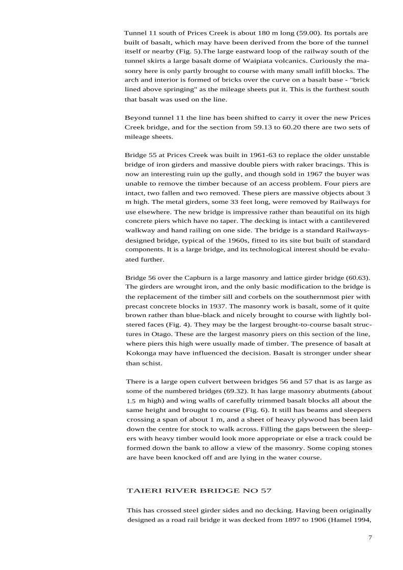
Bridge 56 over the Capburn is a large masonry and lattice girder bridge (60.63).
The girders are wrought iron, and the only basic modification to the bridge is
the replacement of the timber sill and corbels on the southernmost pier with
precast concrete blocks in 1937. The masonry work is basalt, some of it quite
brown rather than blue-black and nicely brought to course with lightly bol-
stered faces (Fig. 4). They may be the largest brought-to-course basalt struc-
tures in Otago. These are the largest masonry piers on this section of the line,
where piers this high were usually made of timber. The presence of basalt at
Kokonga may have influenced the decision. Basalt is stronger under shear
than schist.
There is a large open culvert between bridges 56 and 57 that is as large as
some of the numbered bridges (69.32). It has large masonry abutments (about
1.5 m high) and wing walls of carefully trimmed basalt blocks all about the
same height and brought to course (Fig. 6). It still has beams and sleepers
crossing a span of about 1 m, and a sheet of heavy plywood has been laid
down the centre for stock to walk across. Filling the gaps between the sleep-
ers with heavy timber would look more appropriate or else a track could be
formed down the bank to allow a view of the masonry. Some coping stones
are have been knocked off and are lying in the water course.
TAIERI RIVER BRIDGE NO 57
This has crossed steel girder sides and no decking. Having been originally
designed as a road rail bridge it was decked from 1897 to 1906 (Hamel 1994,
7

App 1:4). The girder work is interesting, and looking down on the tops of the
piers the original wrought iron cylinders for the concrete are still visible.
This system of pouring concrete into iron caissons is similar to the technique
used on the 1870s Balclutha bridge. This is probably the oldest concrete work
on the line still structurally important. It would be appropriate to replace
the wooden decking, but if possible the sides should be filled with netting
and an iron railing rather than with wood.
WAIPIATA BRIDGE NO. 58
Built in 1879 and extensively repaired in 1931, it is a "hybrid" trestle bridge
with some wooden beams and some steel. Its wooden abutments have been
replaced with massive concrete. It has no decking and no rails, and could be
decked and railed without affecting its historic integrity. It has local interest
in that a track to a commonage passed under one end of it.
Waipiata Over bridge No 59. This bridge still has standard wooden piers, set
on concrete bases, with simple wooden railings along the road edge. The
railings are nicely in keeping and should be maintained in this form. Presum-
ably the local authority is responsible for their upkeep.
Bridge 60.This small masonry and beam bridge is like many others and in its
original state. It still has sleepers and should be decked by filling between
the sleepers. If possible heavy wooden railing should be avoided. Half a
basalt coping stone is missing and there is a name painted on one wing wall
which should be cleaned off or smudged out with gray paint.
Bridge 61. This bridge is similar to Bridge 60, except that it lacks any sleep-
ers for decking. It should be treated in the same way as Bridge 60.
Bridge 62 (north of Ranfurly) is similar to Bridges 60 and 61, except that it
has small composite beams which are rotting. These three are small basalt,
single span bridges with the stones all brought to course, and the courses
much the same height. Three lots of capstones on Bridge 62 have been dam-
aged. It still has sleepers and some plywood has been laid down for decking.
Bridge 63 over the Eweburn is an intact trestle bridge with sleepers and cen-
tre rails. The simple three-pile wooden piers are essentially original with some
replacements of piles, but the RSJs may have replaced original timber beams.
The bridge was also reduced in length in 1977 by replacing the three spans at
the north end with an embankment. Its concrete water troughs at each end
have been toppled. The relatively shallow Eweburn would be relatively easy
for horses to cross and a single railing should be sufficient along this bridge.
It could be patterned on the piece of existing wooden railing or that on the
Hyde township bridge.
Bridge 64 is similar in construction to Bridges 60-63. Its orange brown stone
is probably basalt but this is not clear from the available photographs. It is
undamaged, with a deck of slee pers which only require infilling. Horses could
bypass it and only a single railing would be needed at most.
8

Bridge 65 over the Wetherburn is a large wooden trestle bridge with concrete
abutments, on which the wooden beams have not been replaced with girders.
It has been slightly modified in that one span has been filled in with an em-
bankment and the timber sills at each end replaced with concrete abutments,
one of which is obviously new. It still has its sleepers and central rails. One
of the concrete water tanks has been rolled down on to the stream bed. It is
the second most intact trestle bridge after the Gorge Creek bridge (No. 67). It
should also be treated with respect and not modified with wooden railings.
Bridge 66, the road overbridge for State Highway 85 north of Wedderburn, is a
1966 pre-stressed concrete bridge. The abutments of the 1900 bridge are still
visible, but are plain concrete foundations which probably held wooden piles.
It does not require any special historic consideration. The highest point of
the line (2029 feet, 612 m) is just north of this bridge.
Bridge 66a, a private concrete overbridge, is very similar to Bridge 66.
Bridge 67 over Gorge Creek is an long low trestle bridge (11 spans) of hard-
wood beams and piers, with its sleepers and centre rails still in place (Fig. 8).
Built in 1901, this is quite the most interesting bridge on the section of line
between Ranfurly and Ida Valley station and the best purely wooden trestle
bridge on the line. It is only 3.6 m above the ground at the highest point and
68 m long. It should not be modified with modern railing, and alternatives
such as a concrete ford for horses should be considered.
Bridge 67a is a maverick. It was built in 1919 after the main construction
phase of 1901 and crosses a shallow bog beside the Ida Dam. It is an intact
wooden beam and trestle bridge, described as 1.8 m above the water but with
infilling of the bog the grass is almost up to the decking. The sleepers and
centre rail are still in place, and this is another candidate for avoiding modern
railing if possible. The road is very close by.
Bridge 68 is very similar to the many structures described as open culverts
(94.64), built of large schist blocks, brought to course. It is in good condition
except that its sleepers are missing and one capstone has been moved out of
alignment and is likely therefore to be loose.
There is an interesting road bridge north of Ida Valley station for Klifden Road
(97.42). The bridge is in the rail corridor but carries the road across a creek
running beside the rail. It is built in railway style with heavy white painted
posts and four rails (Fig. 4a). It has masonry abutments and is labelled on the
mileage sheets as a cart bridge but has no number in the bridge files. It is a
useful example of a wooden railing in railways style.
Bridges 68a-c. There should have been three cart bridges in the Ida Valley
station yard but only one was identified with any certainty. Only the abut-
ments remain and its only value is as part of the pattern of the station.
Bridge 69 is the Poolburn viaduct, the highest on the line and the one with
the longest span (157 feet for one of the centre spans). It is second longest,
with the first bridge over the Manuherikia being longest at 363 feet. This is
the last of the big masonry bridges built on the line, and even in 1901 it was
9

something of an anomaly. The abutments, 36.8 m high, are made of beauti-
fully trimmed and bolstered stone, all brought perfectly to course (Fig. 2).
The decking is relatively intact with a walking plank and a hand rail on one
side. (There are some missing and broken planks on the walkway.)This rail-
ing is metal pipe and standards and, if necessary for safety, should be dupli-
cated on the other side of the bridge.
Tunnel 12 is the most eastern of the two in the Poolburn Gorge, with nicely
bolstered schist slab facings at the portals, with the arches outlined in brick
(Fig. 7). This is surprising considering how many arched culverts were out-
lined in schist. The interior of the tunnel is a simple brick arch and the floor
smooth gravel. Tunnel 13 to the west has similar portals of well trimmed
schist and the arch outlined in brick.
Bridge 70 (Manuherikia No 1) is the longest bridge on the rail trail and is the
first of the true concrete pier bridges (Fig. 4a). The Taieri Bridge treated con-
crete as something to fill iron cylinders with. The foundations of Bridge 70,
though, were built in the same way by sinking caissons supplied with com-
pressed air for the men to work in. When the caissons were sunk far enough,
the men were taken out and the concrete put in (J Dangerfield: pers. comm.).
The piers are built with a taper, though the taper is less than for the Poolburn
Viaduct piers.They are still more graceful than the sternly vertical piers of
the 1960s Prices Creek bridge. One of the water troughs is missing but the
sleepers and centre rail are intact. The walkway is dangerous as some planks
are missing. There is an iron rail along one side only. This bridge is of suffi-
cient historic importance that it would be worth duplicating the iron railing
on the other side of the bridge.
Bridge 71 over the Lauder Creek (106.0) has similar concrete piers to
Manuherikia No 1 but with large RSJs, rather than the lattice work girders. It
has lost all its decking and railings, though relatively broad tops to the joists
and the shallow drop of less than 3 m to the river bed make it possible for the
intrepid to cross its 31 metres. This is not a bridge of great distinction and a
plain decking and railings would be appropriate. Proportions and design
should be based on railings, such as those on the Hyde Township bridge. One
of its water troughs is missing.
Bridge 72 over Muddy Creek (107.25) is a very nice example of the trestle
and RSJ bridge of the Manuherikia Valley (Fig. 8). Like several of the nearby
bridges it was found that the hardwood beams did not stand up well to the
extremes of climate in the valley, and were replaced in 1933 after only 29
years. Since this is a bridge across a shallow sludge channel, it would be a
good candidate for historical veracity by leaving it as it is without railings
and providing a track alongside the bridge. It still has its sleepers and central
rail. One of the concrete water troughs is missing.
Bridge 73 is an overbridge for Muddy Creek Road which still has its old wooden
beams and trestles but the latter are on concrete bases. It has an appropriate
white railing, in slight disrepair, but other wise like the Waipiata overbridge it
is very much as it was originally built. It should be maintained in this form.
Presumably the local authority is responsible for its upkeep.
10

Bridge 74 is shown as crossing Spottis Creek, but definitely crosses Thomsons
Creek out of Thomsons Gorge. The bridge sheets recognise it as the Thomsons
Creek bridge. This is a relatively humble bridge of girders on concrete piers,
which do show some innovation in their fancy corniced tops. There is some
mystery about its piers which are shown on the mileage sheet as four, but
there are only two freestanding piers and the two ends of the bridge are on
concrete sills on solid rock outcrops. There is no indication that the bridge
has been shortened. One of its water butts has gone and the other is on its
side. It still has an intact decking and centre rail. Since Thomsons Creek drains
a large catchment, a ford it likely to be impractical and this bridge should
have appropriate railings, similar to those on the Hyde Township Bridge.
Bridge 74a is the Tiger Hill overbridge for Highway 85, a neat modern rein-
forced concrete bridge built in 1961. The railway was dropped into a sub-
stantial cutting to run under this bridge.
Bridge 75 is a standard single span masonry bridge for a farm access, made of
carefully trimmed and brought to course stones with neat wing walls and
coping stones intact. The farmer has filled and gravelled the decking for stock
access. This bridge should not have railings, and a track should be formed to
bypass it.
Bridge 76 north of Chatto Creek is really only an open culvert and almost
buried in long grass. It has lost its decking but otherwise is intact. It should
be treated with respect and not have railings put on it.
Bridge 77 is the second bridge over the Manuherikia and the third longest.
All the sleepers and any railings that it had were removed, leaving the bare
girders. At the time of the survey it had already been about one third redecked
and edged with relatively heavy and obtrusive railings. No attempt has been
made to imitate the standard railways design of railing. This is a fine example
of a wooden trestle bridge with doubled piers and raker braces, but like other
Manuherikia bridges its timber beams have been replaced by RSJs (Fig. 8). It
is surprising that its piers were not built in concrete like the other two bridges
over the Manuherikia. It is the highest of the wooden trestle bridges on the
rail trail, Muttontown Gully and Hyde township coming close to it. It is an
important bridge on this section of the line and should be given prominence
as the highest wooden trestle bridge. It is the most difficult of the big bridges
to get to from a public road.
Bridge 78 is an overbridge for farm access for Olrig . It is intact with sleepers
and centre rails on a single span of RSJs set on simple concrete abutments. It
is a very simple bridge only 3 rn off the ground and could be left exactly as it
is.
Bridge 79 is a low bridge over Moss or Dip Creek just north of Galloway (124.5).
It is another of the trestle bridges which had to have its beams replaced with
triple RSJs in 1949. An extra span was added at the north end in 1916, and
later it was reduced by three spans.Though it is still a respectable length, it
has neither grandeur nor historic interest. It is an average sort of bridge. It
has entirely lost its decking, and being only 2.6 m above the ground at most
it probably does not need a railing.
1 1

Bridge 80 is a sorry sight - it has become a small raupo swamp across the line
(126.29). Its beams have gone and its concrete abutments submerged in veg-
etation. Curiously the water course under it is marked on the mileage sheet
as Dredge Road and curves back across the line at 126.41 where there are
still two sign posts. It is difficult to know whether this is a road to a dredge
on the Manorburn or a track formed by a dredge working across dry land.
The problem was not sorted out during the survey.
Bridge 81 over the Manorburn is only half the bridge it was (126.58). It was
built as an 18 span trestle bridge to rival the one at Muttontown, but after 40
years of Central Otago weather the ironbark beams had split. Some of the
piers had been badly driven, and there is a hair-raising letter in the files from
an inspector, describing how he stood under the bridge and measured the dip
as an engine passed over it. The beams were replaced with RSJs and nine of
the spans filled in. The bridge has been completely redecked and wooden
railings put down both sides, with round tanalised posts at each end. Again
this would be a suitable bridge for interpretation with a track down the easy
slope of the bank to allow the public to view the impressive trestle-work
underneath.
Bridge 82 is a very shallow open culvert with its beams still in place only 60
cm above the ground (126.65). It barely needs redecking as it is so easy to
bypass. Its abutments appear to be a mix of masonry and concrete.
Bridge 83 was once a four-span bridge with concrete abutments (127.2). In
1936 it was partially filled in with spoil from a slip in the Cromwell Gorge
(which sounds familiar), and a very plain square concrete culvert put in place.
It has no frills such as a mock coping.
Bridge 84 is the familiar masonry open culvert only 3 m across and only about
a metre above the ground (127.29). The masonry is as lovingly brought to
course as ever, but only two cross beams remain with spikes sticking out. A
well-worn track bypasses it and like Bridge 82 it could remain as it is. (My
faith in the mileage sheets is somewhat shaken by this bridge being described
as an open concrete culvert.)
Bridge 85 is the extant road-rail bridge over the Manuherikia at Alexandra
(Manuherikia No 3 on the line at 128.46). The wide central span of 100 feet
was to allow dredges through, but it is not the longest span on the line. Its
concrete piers have a nice taper and a small coping at the top, which makes
them look more like the masonry piers of the Poolburn bridge than the mod-
ern vertical piers of the 1960s Prices Bridge. The rivetted plate girders at
each end and the big lattice steel girder in the middle give it a turn-of-the-
century industrial look. The white wooden railing (in the 1980 photo) looks
relatively modern, and with only two rails is relatively lightly built.
Bridge 86, the Muttontown viaduct, is the only bridge between Alexandra and
Clyde (132.48). It is the longest trestle bridge on the rail trail, but like so
many of the trestle bridges in Central Otago its hardwood beams have been
replaced with RSJs. (One of them is stamped Dorman Long and Co, Middles-
borough, England, an interesting contrast to the original wrought iron gird-
ers, manufactured by Andersons of Christchurch in a temporary foundry at
12

Wingatui.) It has raker braces but the piers are not doubled (Fig. 8). The only
signal on the trail stands 200 m east of the bridge and presumably was to
control movement across the bridge.There is a large pile of rails at the west
end of the bridge. The deck of the bridge has been rebuilt and unpainted
timber railings run down both sides with round tanalised posts at each end.
Culverts are not to be despised
The masonry culverts along the trail have been built in two basic forms. The
larger ones have arched profiles and the smaller ones are square with massive
lintel stones. The arches are invariably very well built, with the stones per-
fectly trimmed to form an even arch, and the surrounding stones brought to
course, i.e. trimmed to the same height. At least two built of basalt, one arched
and one square, have not been entirely built to course, which suggests that
the reasons for such careful work were not solely structural (Fig. 5). Many of
the grand stone buildings of the Strath Taieri, such as the Cottesbrook
woolshed, are random built and not brought to course. Most retaining walls,
around Dunedin, even some up to 3 m high are only partly brought to course.
(Fig. 2). It is quite surprising that so much trouble was taken with such small
structures as culverts and minor bridges.
Walking north from Middlemarch Station, small bridges and culverts of all
sizes are well made in schist blocks all brought to course, with the courses
mostly the same height and a neat row of shallow coping stones along the
parapets.
A small square culvert north of Dewar Stream (41.22) is blocked at one end.
The arched culvert (41.46) near a row of Lombardy poplars halfway between
Dewar Stream and Camltt Creek is the first of this handsome type of culvert
which visitors walking north from Middlemarch will see and is well worth
i nterpreting. There is a small area of erosion behind one of the parapets,
probably caused by stock, which needs to be filled in. The masonry culverts
over this section are in good repair, though there is one coping stone missing
from a wing wall of the arched culvert at 43.32. The mileage sheets do show
concrete and earthenware pipes as well, some of which probably date from
the time of the initial construction, but some will be modern.
The big open culvert 350 m south of Bridge 40 is a good substantial example
of schist masonry (44.24). It is only 2.5 m long and will not require railings.
It is intact with its wooden beams still in place and could be included in any
i nterpretation developed at the two bridges immediately to the north (Bridges
40 and 41).
Culverts are sparse between Bridges 40 and 45. A short open culvert north of
Bridge 45 has lost its beams and decking (48.51), but an arched culvert north
of Bridge 46 is in perfect condition (48.78). Between Bridges 47 and 48 there
is both a square and an arched masonry culvert in good condition (49.66 and
49.68). One of the larger arched masonry culverts is 320 m north of the
13

Boundary Creek bridge with an arch 10 feet high and 8 feet wide with a nicely
cobbled channel for the creek (51.42). There are three more intact masonry
culverts over the next 1.5 kilometres, the section which passes the memorial
to the Hyde train disaster. Between Six Mile Creek and the Scrub Burn ( about
3 k) there are seven masonry culverts, all intact except one which has its
portal replaced with concrete, and another seven between the Scrub Burn
and Hyde Station, all intact.
An irrigation pipe crosses the line about 750 m south of the Scrub Burn bridge
(53.72). It is carried on a slender wooden trestle so in keeping with other
trestle work that it may be original. Certainly the evidence from the mileage
sheets suggests that it was there when the line was built. The bank at the
eastern end is eroding and the main beam slumping. There is an identical one
north of Hyde station at 55.77.
Between Hyde railway station and Hyde the masonry culverts are in poor shape
and concrete abutments have been attached to earthenware pipes. North of
Hyde township the use of concrete abutments for pipes less than 40 cm in
diameter is a hesitant start on the use of concrete for small water courses.
The shapes imitate the masonry ones (58.20). In some cases the whole earth-
enware pipe and old concrete has been broken out, and new concrete pipes
put in (57.75). Masonry continues to be used for larger culverts but some
have been repaired or replaced with concrete (57.26). About 1 km south of
Tunnel 11, a masonry culvert has been broken up (58.28) and there is a slab
of masonry lying in the creek which could possibly be retrieved for repairing
less damaged culverts.
On the section north of Hyde there was a lot of use of timber boxed drains
which have been replaced with concrete piping, as well as numerous con-
crete pipes. There are almost no masonry culverts on the section from Hyde
to Tiroiti, but they come into use again north of Tiroiti ( three between 62.51
and 62.63). The last of these three has collapsed.
Around and north of Kokonga, schist is replaced by basalt, probably from a
series of small quarries in the Waipiata volcanics, which outcrop from Hyde
to Kokonga to just south of Waipiata. It is unlikely that the quarry for the
Dunedin Railway Station was used, as that quarry was specifically opened by
a group of engineers after a special field visit about 1903. Basalt is used from
Prices Tunnel to as far north as Bridge 62 (77.55) north of Ranfurly. The stones
have usually been just as neatly flaked to course as the schist of the other
bridges and culverts. North of Tiroiti, though, basalt rubble was used to form
what the mileage sheets call boulder drains. These probably had timber or
concrete pipes which where then filled over with basalt rubble as at 61.20.
Even though basalt was being obtained from Kokonga for this stretch of line,
schist was still used for the large culverts. Just south of where SH 87 crosses
the line at Daisybank, there are three large arched culverts ( 4 x 4 feet and 4
x 4.5 feet across) at 63.20, 63.39 and 63.5, and two to the north (6 x 5 feet
and 2 x 2.75 feet at 63.68 and 64.05). The first of these at 63.20 is notable for
an unusuall y long wing wall, all in well-trimmed schist. North of Daisybank
the line crosses a peculiar stretch of ground for about 250 metres which re-
quired about a dozen boulder drains and 12 inch diameter earthenware pipes
14

(64.10 -64.24). South of Kokonga there are two small intact masonry cul-
verts, built of basalt, one arched and the other square (65.32 and 65.44). The
arched one is interesting in that the stones are not all perfectly brought to
course and the courses vary greatly in depth. Likewise a square culvert just
north of Kokonga has irregularly shaped stones in it and various depths of
course (66.57). These were the only two seen with irregular courses.
An open culvert north of Kokonga is really a small bridge with basalt abut-
ments and wing walls (69.32). It is a handsome structure but some of the
parapet stones have been knocked off and are lying on a dry creek bed below
it. Another small culvert near Taieri Lake has had one or two basalt coping
stones knocked off the western parapet (70.1). This is the beginning of a trail
of minor vandalism, where it looks as if somebody has deliberately knocked a
few stones off each bridge or culvert parapet.
Many of the culverts have neatly cobble-laid floors such as the one at 74.67,
about 3.5 k south of Ranfurly, a large arched basalt culvert. There are at least
two basalt open-culverts (and possibly a filled-in third) about 1.5 k south of
Ranfurly, built like small bridges, with beams from which the sleepers have
been removed. One of them did not seem to have any flow of water and the
missing one was described as a flood opening. Two basalt coping stones have
been knocked off the southern one at 75.38. These should have simple
deckings and no railings, since otherwise they are in their original state.
Immediately north of Ranfurly Station (76.79), there is a nasty example of
what can happen to a masonry culvert.The basalt masonry has been partly
dismantled and a concrete pipe cemented in. To add insult to injury the flow
through the pipe seems to be polluted with tar or coal effluent. Since this
culvert is so close to Ranfurly station, there is a good argument to restore it to
its original state, as well as clean up the effluent which it is to be hoped was
temporary.
Another masonry culvert has been more massively replaced further north
(79.17) on the south side of the crossing for the Gimmerburn-Naseby Road.
Only the basalt masonry wing walls project from the concrete. It is probably
not practical to restore this culvert. It is the most northern of the basalt cul-
verts.
The first of the well-built schist culverts north of the basalt section is a hand-
some small domed culvert at 80.51, about 1.5 k south of where Brinsdon
Road crosses the line. There is an even more attractively designed one imme-
diately south of Wedderburn (85.7).
South of where Brinsdon Road crosses the line (81.42), another masonry cul-
vert has been heavily modified and a very ugly concrete culvert put in place
which has partly eroded. This probably needs functional repairs. Eden Creek
has caused serious slumping and the masonry culvert has vanished entirely.
It has been replaced by two concrete pipes with an ugly slurry of concrete
spreading up the bank above them.
North of the road crossing at Wedderburn (85.36) an open masonry culvert
has been replaced in concrete. South of the Wedderburn overbridge for State
1 5

Highway 85, an arched schist masonry culvert has been modified with a band
of concrete one course down from the top and out along the wing walls
(86.24). It appears to have been neatly done and to be less offensive than the
ones to the south. It may be worth investigating this as a compromise where
proper masonry repair is not feasible.
North of the Wedderburn road overbridge the schist culverts at 86.48 and
86.61 are unmodified though showing some tendency to block with fallen
ballast. Immediately west of the private overbridge where the line meets the
Idaburn, there is a row of three particularly nicely built schist culverts along
40 metres of line (89.26 to 89.28). They are all arched and most have short
wing walls which do not flare out sideways as much as usual. These wing
walls are finished with particularly large coping stones. The stone work is as
meticulous as ever. 240 metres further up the line an open masonry culvert,
i.e. small bridge, has lost several stones and needs repairing (89.40), as does
another similar culvert at 89.48. The schist capping stones have been knocked
off. 160 metres up the track there is a very small square culvert which has
been so heavily modified with concrete that it may be a reasonable compro-
mise to take the few schist slabs still lying near it to mend the other less
damaged structures.
Between 89.70 and 90.38, i.e. over the next kilometre there are five masonry
culverts, of which only the most eastern has been modified by inserting a
concrete pipe. West of mile 92, out of three masonry culverts only one, an
open culvert (92.1), is intact, the others having been infilled with concrete
pipes. Scattered stones from these may be a useful source for mending other
culverts. South of Oturehua the arched culvert on the north side of the Gorge
Creek bridge is intact, except for a missing coping stone.
On either side of where the Ida Valley road crosses the line beside the Ida
Dam, there are good examples of intact open culverts, built like small bridges
with undamaged coping stones (93.63, 94.17, 94.46). West of where Agnew
Road crosses in the Ida Valley, there are three masonry culverts of which only
the eastern one (95.55) is intact (one cap stone missing). The other two have
been badly damaged by infilling with concrete pipes and ballast (95.78 and
96.55).
South of Ida Valley Station the line runs along the edge of the hills and re-
quired numerous culverts. A different engineer compiled the mileage sheets
and has drawn profiles of the culverts with the size of the opening annotated
beside them. They are all arched and square culverts, none are open and
almost all are in good condition without any concrete pipes or damage to
copings. There are about 25 culverts spread out over four miles, and in all
except one that has been reduced to rubble (100.25) the schist slabs have all
been completely trimmed and brought to course. A few of this group are
tending to fill with ballast and sediment, such as the ones at 99.44 and 99.52.
Though the Poolburn Viaduct is the last of the big masonry bridges, masons
still trimmed stone for the portals of the two tunnels and continued building
culverts along the rest of the line. Of the two culverts between the tunnels,
one has been virtually demolished and replaced with a concrete pipe and the
other has had a concrete channel run down the hillside from it. West of the
1 6

tunnels the culverts have suffered (at 103.59 there is a concrete pipe buried
under rubble, at 103.63 the culvert is half blocked with rubbish and at 104.13
wholly blocked). There are four more intact masonry culverts over the next
mile (104.20 - 104.62) and immediately east of the first freestanding concrete
bridge, Manuherikia No. 1. West of this bridge there is a swampy section where
a culvert seems to have been removed (105.40). Masonry culverts continued
to be built near Lauder, one on either side of the bridge (105.56 and 106.31).
A change from masonry to boxed concrete culverts, made when the line was
first put in, begin to appear in the Manuherikia Valley. By looking at the con-
sistency of writing styles on the mileage sheets, it is possible to detect which
concrete culverts were installed at the time of initial construction and which
were put in later. Starting from Lauder station, open concrete culverts begin
to appear, the first immediately south of Lauder at 106.70, 107.5 and 107.15
and just north of Muddy Creek bridge. The last of these has lost its decking.
South of Muddy Creek overbridge the overlap in technology is nicely demon-
strated over a 400 metre length of the line (108.53 - 108.73). At the north end
of this section a race is carried under the line in a concrete siphon with quite
elaborate concrete abutments. In the middle (108.66) there is a nicely arched
schist culvert, all the stones brought to course, and at the south end there is
a square masonry culvert which has had its lintel stone replaced with a con-
crete beam. Concrete and masonry now alternate along the line to the south
to Huddleston Road and beyond. An open culvert about a kilometre north of
Omakau is a neat piece of masonry and still has its decking (110.24). South
of Omakau there is the remains of a masonry culvert at 111.26 that has been
replaced with modern concrete piping, but a drain further on (111.61) has
always been in a concrete channel.
The decision whether to use concrete or masonry in the lower Manuherikia
at first depended mostly on size. The large open culverts tended to be con-
crete. To the north of the Highway 85 overbridge, there are three masonry
culverts covering the whole range from a large open culvert to a small arched
one, but in among them are two large open ones in concrete (112.74 - 113.58).
The open masonry one has been filled in (113.32.). Then the attitude changed
back again. Masonry was the choice for all sizes over the next five miles
down to Chatto Creek, including the bridges. The easy availability of stone
from the numerous cuttings may have been a factor over this stretch of line.
For the first time on the whole survey some badly weathered masonry was
seen at a small square culvert north of Chatto Creek (116.8). Further south a
masonry culvert has had concrete wing walls added to it and a concrete pipe
i nserted relatively neatly (116.31). This is a good example of respectful treat-
ment of a masonry culvert if concrete has to be used to repair it.
Masonry culverts continue beyond Chatto Creek (nine between 118.68 and
Manuherikia No 2 bridge), with one small one at 118.68 which has been filled
with a concrete pipe and wing wall in quite a ticly manner but with an ugly
result. Another close to the bridge has been filled with ballast and one of its
coping stones knocked off (120.26). There is likely to be a drainage problem
here.
17

A small culvert which seems to have been concrete all its life appears imme-
diately south of Manuherikia No 2 bridge (12 1.11) with a neatly formed arch
and a parapet edge imitating coping stones. As far as 123.24, even where the
mileage sheet says masonry the culverts are concrete, from narrow drains
only a foot across to small bridges, such as the one at 122.49 two kilometres
north of Galloway which has been redecked by the Department of Conserva-
tion. This has only a two metre span and less than a two metre drop, and so
has not required railings. Its concrete abutments have also been finished
with a small coping to imitate the masonry abutments. The next one down
the line is similar but has only beams and no decking as yet (123.42). Con-
crete culverts, nicely arched and with imitation copings, dominate the rest of
the line to Alexandra, e.g. at 127.41 and 127.48, with only three masonry ones
out of about a dozen. Right to the end the quality of stonework is maintained,
e.g. 128.26 just north of the Manuherikia No 3 bridge.
There are only seven culverts marked between Clyde and Alexandra, most of
which have been filled in, and the remainder are concrete.
Though very repetitive, I hope that this description of the culverts provides
an impression of the dozens of beautifully made small stone structures along
the line and the threats to their continued existence. The details on location
should enable people to find particular culverts by using the mileage maps
(Fig. 1).
Less common items along theline
The position of each item is given relative to some geographic feature and its
mileage position.
LINESMEN'S HUTS
A corrugated iron but 300 m south of Wandle Creek is in good condition ex-
cept that the whole chimney has gone (45.55). Unlike many huts it still has
its door with a small window in it, tongue and groove flooring and ceiling, a
wooden beading around the square of tin where there was probably a pot-
belly stove, the remains of oiled paper lining on the walls and a wooden seat
against one wall. This would be a useful prototype for restoring shelter huts
on other sections of the line.
A weatherboard but with an intact door still stands at the junction of the old
and new pieces of line south of Prices Creek bridge (59.51). It also has an
intact door with a small window. Eroding ground around it is pressing against
its walls on two sides. This may be the only wooden but on the line and
should be kept well painted.
1 8

There are two crumpled tin chimneys near Taieri Lake (69.38). A corrugated
iron but north of Taieri River Bridge 57 is intact except for the top of the
chimney (71.60). A corrugated iron hilt 3 kilometres south of Ranfurly at 75.1,
has been shifted on to the formation and is about to lose its roof. Its chimney
is lying beside it but it could be readily restored.
A corrugated iron hut, about 2 km south of where the line crosses the Ida
Valley Road, is in better condition that the previous huts (95.20). Its chimney
is intact, though the door is missing.
A corrugated iron but further south appears to be in good condition with a
chimney made of stone and a concrete pipe (103.70).
A corrugated iron but at the east end of the Manuherikia No 1 Bridge has
collapsed entirely (105.10). Its iron could be used to repair other more in-
tact huts, such as the one south of Wandle Creek, and only its site marked.
About 1.5 km south of Omakau, the mileage sheets mark Corrigall's House off
to the west of the line.There is still a stone ruin among poplars on the site.
Corrigal Road crosses the line 3 km to the south of here. James Corrigal was
a local farmer in the 1890s and may have housed work gangs at his farm build-
i ngs.
There is another collapsed corrugated iron hilt south of Omakau against a
bluff (113.1). It also could be used to repair more intact huts and only its site
marked.
In the loop north of Chatto Creek there is a large flattened area that looks
like a small siding, but has only the remains of a tin chimney and some foun-
dation stones of a hilt (115.27). The site should be left as it is until more is
known about it.
About a kilometre north of Galloway there is a relatively intact corrugated
iron hilt which lacks only the top of its chimney which is lying nearby (122.77).
It has an earth floor and some broken benches inside. It looks as if it could
readily be restored to provide a good example of the working conditions of
the men who maintained the line.
RETAINING WALLS
Near Kokonga several cuttings have low retaining walls of basalt built along
the base, as at 64.47 and 66.38. South of Ida Valley station (100.2) there is a
low wall of sleepers held in place by lengths of rail hammered into the ground,
and similarly north of Chatto Creek pegged sleepers have been used to hold
the ballast on the outside of a curve (116.2).
There are other modest retaining walls here and there along the line, but
they are not a distinctive feature of the line.
1 9
RAILWAY GATES
These are very distinctive wooden gates, painted white and hung from heavy
squared posts which may be stayed with bent rails. Not all were not described
during the survey, but the following were noted.
One was seen in a neighbouring farmer's fence at 45.10 (north of where
Ngapuna Station is marked on the topographic maps), and there also is a pe-
destrian turnstile on the north side of Rock and Pillar Station site. There is a
pair of gates with bent rails for stays north of Last Creek at 48.36 for a private
level crossing. There is a similar pair immediately north of Bridge 46 over
House Creek. This section seems to be a good place to see ballast stores
made of old sleepers and a wide range of mileage posts. During the working
life of the line, the posts changed in style from wooden to concrete, and even
after the line was metricated the old familiar mileage posts were retained
because the linemen were more used to them. Bridge 47 can be photographed
with a typical railway gate in the foreground. There is a pair of gates for a
private level crossing south of Gills Creek (50.35) and another pair south of
Boundary Creek (50.13). Many of these gates are relatively new. Immediately
north of the Six Mile Creek bridge a railway gate has a well-worn "Trespassers
will be prosecuted" sign.
A gate is still in place south of the Ida Dam at 94.11, and another one east of
Ida Valley Station (97.1). Another had been shifted into a farmer's fence south
of Omakau (112.66).There is a good pair still in place for a private road south
of the Tiger Hill overbridge (114.40) and two sets north of Chatto Creek at
115.64. Another set where SH85 crosses the line 2 km north of Chatto Creek
have iron uprights and four wooden rails.
These gates are very distinctive and an integral part of the "railway look".
Farmers should be discouraged from removing them and they should be in-
cluded in a maintenance schedule for repair and painting.
Discussion
Without doubt the bridges and the numerous masonry culverts are the most
interesting historic features on the rail trail. Nowhere else in New Zealand
can one see such lovely stone work on a railway. It is likely that the culverts
and bridge abutments represent the largest single project in Otago (and pos-
sibly in New Zealand) in which perfectly brought-to-course masonry was used.
(The bridge abutments of the first section of the line in the Taieri Gorge are
similar.)The only brought-to-course masonry of stone that is chipped to shape,
rather than sawn, seen around to Dunedin is in the massive foundations of
some buildings which are made of Port Chalmers breccia. In Central Otago
there are other bridge abutments and buildings in schist which are also brought
to course, such as the Ophir post office, the old Alexandra bridge piers and
the Kawarau suspension bridge. These are all schist structures, and I have not
yet located a basalt structure brought to course.
20

On the rail trail, there is the added bonus that both basalt and schist work is
represented. As far as we know the builders were Polish, German and Italian
stonemasons who had emigrated to the gold fields. After the easily won gold
ran out in the 1880s, they reverted to their old trade and were employed on
the line (J Dangerfield: pers. comm.). Much of the line was built under a
system of work gangs appointing their own foreman who received instruc-
tions from the Railways engineer. One must assume that it was the engineer
who decided that the stone masonry should be brought to course for reasons
of strength.
STATIONS
The stations and sidings were more socially important, linking the commu-
nity to its lifeline. The groups of structures which were built at each station
varied widely, from a solitary loading platform to a small village of houses and
sheds. Most buildings have been sold and relocated, and those that are left are
all the more important. Only Hyde, Ranfurly and Clyde still have their station
buildings, though the Wedderburn one is still visible in the back garden of the
local hotel. Goods sheds are still in place at Ranfurly and Omakau, and the
one at Waipiata is still close to the line. (The Wedderburn one has gone to a
local coal pit.) There are several railway houses still in their original paint
work beside the corridor, as at Waipiata, Oturehua, Chatto Creek and Alexan-
dra. The railway hotel at Ida Valley Station is an impressive isolated building.
Loading ramps and station platforms are the commonest remaining structures,
and there are some point levers, road crossing signs, and one signal light
(Muttontown Bridge). The mileage sheets provide a means of reconstructing
the pattern of any given station where this might be wanted. (An interesting
variation recorded on the sheets is the function of the small building near the
station. Why did Tiroiti, Kokonga, Waipiata, Ranfurly, Lauder and Omakau have
urinals only, Wedderburn had urinals and privies (plural), Ida Valley and
Oturehua had privies only and Chatto Creek had a urinal and a WC? Unfortu-
nately none of these remain.)
It could be worth entering into arrangements, formal or informal, with own-
ers of buildings which were once part of the railway system, in order to main-
tain their visual integrity as seen from the trail. These might include paying
for a qualified sign writer to repaint the name on the Waipiata goods shed,
paying for the repair of old sash windows on ex-railway houses in preference
to their replacement with aluminium windows, and advice on paint schemes.
This level of community involvement could have other good effects. Where
land is sold off from around stations, any remnants such as the posts sur-
rounding the house sites at Kokonga and the concrete path and trees should
be covenanted and right of access retained. Railway gates leading into neigh-
bour's properties should be included such arrangements.
In considering the preservation of the line, the classificatory approach of this
report should be used cautiously. The positions of all stations should be
marked to indicate the importance of the line to the local communities, but
only the best remaining structures should be preserved. The Taieri Lake sid-
i ng in particular should be marked and its link to the Dunedin railway station
building commented on somewhere in the interpretive material.
21

BRIDGES
Some of the reasons for choosing different materials for the bridges had to do
with technological change, such as increasing use of concrete instead of ma-
sonry and the use of RSJs instead of wrought iron for plate and lattice girders.
The two years and five kilometres between the Poolburn bridge and
Manuherikia No 1 bridge marked a major change in technology. Masonry af-
ter this was used only for culverts and single span bridges. The big bridges
from now on were concrete, metal girders and massive timbers. The replace-
ment of wooden beams by RSJs in the Manuherikia was an effect of climate,
rather than a change in technology.
The reason for the difference in pier construction of the wooden bridges
lying between Six Mile Creek and Wether Burn is not so obvious. The Heeneys
Creek, Waipiata and Ewe Burn bridges have simple piers of three piles, but
Coal Creek, Hyde township and the old Prices Creek bridge in between have
doubled-up piles and raker braces.This strengthening was used where there
were longer spans or likely to be damage from large boulders during floods
(Robert Storm: pers. comm.). Heeneys Creek,Waipiata and Ewe Burn bridges
have spans of about 14 feet, 21 and 21 feet respectively, whereas Coal Creek,
Hyde Township and old Prices Creek bridges have spans of about 30 feet.
Judging by the topographic map, it looks as if both Heeneys and Coal Creek
coming down off the steep slopes of the Rock and Pillar Range could throw
boulders at the bridges with equal viciousness, but Coal Creek flows through
unstable Tertiary sediments. It and Prices Creek probably have a better sup-
ply of boulders than Heeneys Creek, and hence the greater strength in the
bridge piers. The Waipiata and Eweburn bridges are out on the gentler gradi-
ents of the Maniototo Plain. In the Manuherikia Valley it is only the two long
spans of Muttontown and Manuherikia No 2 bridges which have doubled up
piers and/or raker braces.
The two things that the public are most likely to want to know when they
visit the trail are distances/times and what there is to see. Bridges and tun-
nels fascinate most people, and the larger bridges are likely to attract the
first-time visitor. The Prices Creek tunnel could be used to explain about the
use of Waipiata basalt. A major bridge on each section of the trail should be
chosen for general interpretation, as well as the obvious sites at Middlemarch
and Clyde. (There is so little to see at Alexandra station that the DoC office
would be a better display site for the trail.)
The bridges could be interpreted in groups along each section of the line. On
the Strath Taieri section Bridges 37 to 46 have good masonry, especially Nos
40 and 41. At Hyde the township bridge is the obvious site for a panel about
trestle bridges with double piles and raker braces. In the Maniototo interpre-
tation should focus on the Wetherburn bridge as an intact example of a wooden
trestle. In the Ida Valley the Poolburn viaduct will attract most interest, and
the importance of the perfect masonry along the line could be discussed here.
At Manuherikia No 1 the focus could be on the evolution of the use of con-
crete for piers. To complete the series, it would be appropriate to have a
good photograph of the Leaning Rock Creek Bridge placed on an interpretive
panel at Alexandra or Clyde (Dangerfield and Emerson 1965:42). Built about
1916, it was one of the first concrete arch bridges in the South Island, but was
demolished by the Clyde Dam works.
2 2

Some of the bridges should be chosen as places for short walks and a casual
picnic site by the river. The largest tend to be high above the river and not so
suitable for picnicking. Long low bridges would be a better choice. On the
Strath Taieri, the modest but interesting trestle bridge over Heeneys Creek
(No 47) would be a suitable site if planted with a few willows for shelter. Six
Mile Bridge No. 50, with its masonry abutments and lattice girder, forms an
interesting pair with Heeneys Creek (Fig. 4). Bridge 67 about a kilometre
south of Oturehua is important as the best preserved long trestle bridge on
the line, and crosses a shallow creek. It is opposite the gate to the historic
buildings of Hayes Engineering, owned by the Historic Places Trust, and could
form a useful group with them for visitors interested in historic sites. The
Wether Burn Bridge is similar, a low trestle bridge over a shallow creek close
to access from Wedderburn township.
The presence of so much perfectly brought to course masonry on the bridges
and culverts warrants very careful treatment. Many bridges should not be
modified with wooden railings. A system of bypasses, using fords and wooden
foot bridges, which encourage walkers to look at the masonry would be de-
sirable. This would also overcome many safety problems.
Under the draft CMS, designs for bridge decking and hand rails should have
regard to the intended use, safety and historical integrity. When considering
historic integrity, bridge repairs and modifications should be according to
ICOMOS charter principles. Where the larger bridges must be provided with
decking and railings for safety and as the only feasible way of getting across a
river, short access tracks should be provided to an interpretation panel.The
track should lead people to a safe vantage point where they can see the origi-
nal lower part of the bridge, and the panel should identify the deck and
railing as modern, as well as provide a brief history.
There are several bridges with railings installed by the Railways Department.
The pipe and metal stanchion railing on the Six Mile Bridge has a good Victo-
rian appearance, but the one on the Hyde Township looks to be more recent.
The new bridge over Prices Creek has a wooden top rail, wire mesh sides
with metal stanchions which could be an economic alternative to the solid
Victorian design on the Six Mile Bridge. A simple wooden railing with square
and notched posts at each end is still in place on a road bridge with no number
north of Ida Valley station for Klifden Road (97.42). (The road has to cross a
creek which runs in the rail corridor parallel to the line.) It would be a much
more appropriate style than those built by Task Force Green with round
unpainted tanalised posts at each end. White paint for railings and dark red
for the tin sheds would give them an authentic railways look. The bare wooden
railings on Muttontown, Manorburn and Manuherikia No 2 bridges would all
look much more in keeping if painted, and if the round tanalised posts were
replaced with squared and notched wooden ones.
One interesting side line of research could be to compare the original heights
of bridges and culverts with the present heights above the water or ground.
Photographs of some of the smaller bridges and larger open culverts show
dramatic changes. These may also have safety implications.
23

CULVERTS
Two good sections of line for viewing masonry culverts are south of Hyde
station to bridge 45, over Last Creek and south of Ida Valley station to Poolburn
bridge. These are schist culverts. The basalt ones are best seen between
Kokonga and Ranfurly.
Some careful policy decisions need to be made on masonry culverts. Firstly,
they must be maintained as effective drains, but secondly the original stone
work or early concrete should be preserved wherever possible. Criteria should
be established to decide how to treat damaged culverts, based on the ICOMOS
charter principles. For example, no new stone should be added to broken
culverts. Where stones from breaks have disappeared and no suitable stone
can be obtained by 'cannibalising' other badly broken culverts, the break should
be stabilised but not `tidied up' with a layer of concrete, unless there are safety
reasons involved. There should be clear distinctions between old and new
work. Non-weight bearing damage should be repaired with stone wherever
possible. Coping stones should be replaced and the stonework made to look
neat and firm to deter further vandalism. (A recipe for an appropriate mortar
could be obtained from Ian Bowman.)
Where a culvert has to be repaired with concrete, the two or three neat ex-
amples described above should be used as models, e.g. one south of the Wed-
derburn overbridge (86.24). If there is an opportunity to repair a culvert that
has already been partly concreted, as many stones as possible should be re-
trieved and the whole culvert concreted, so as to remove the hybrid appear-
ance. It is desirable that the public should think that stone culverts are mostly
maintained in stone. A sense of respect for the stone work should be con-
veyed by the work done on the culverts. The culverts with concrete spread
in a formless mass on the surface, as at Eden Creek, should be scheduled for
remedial work when money is available. The concrete should be actually bro-
ken up and replaced with neatly boxed work which imitates the stone cul-
verts. My impression is that there are very few culverts that need this type of
work done to them.
Priorities should be established that combine maintaining the drainage capa-
bility of the culverts and the integrity of their historic stonework. Where two
culverts are equally clear of debris but need some remedial maintenance, the
one with the best stonework should be dealt with first. Keeping drains clear
of vegetation and debris requires regular maintenance, and it is surprising
how effective a man with a shovel can be at the right moment. If any neigh-
bouring farmer offers to keep an eye on his stretch of line, he should be en-
couraged with whatever perks the Department can provide (free hut passes?).
The linesman who knew which drains would give trouble after a particular
level of rainfall was a valuable asset which the Department cannot replace.
The smaller items along the trail should be given their place. The linesmen's
huts should be sufficiently repaired and painted dark red to extend their life,
and provide shelter for the trail users. They should be left though in their
simple state, as they were when used by the linemen. The one south of Wandle
Creek is probably the most intact and could be used as a prototype. The
typical white gates and bent railway line stays should be kept painted and
24

repaired as required. Since the gates usually give access into neighbouring
farmers' paddocks, agreement over their maintenance is an opportunity for
contact with neighbours. Marker posts should be discretely concreted into
place to preserve them from theft.
The main reason for setting up the rail trail was recreational-to provide a
low altitude walking, cycling and horse riding track..The scenery over much
of the trail is grand in scale and tends to lack detail to arrest the eye. There is
a good opportunity here to encourage an interest in the historic details of the
trail and to tell its users about the unique nature of the brought-to-course
masonry of the bridges and culverts.
Acknowledgements
I am most grateful to the people who painfully cycled the heavy ballast on
the line and photographed each bridge and many of the culverts. They have
provided an invaluable record. I am again grateful to Jim Dangerfield for shar-
ing his compendious knowledge of railway matters and for his enlightening
and stimulating discussion.
References
Hamel, J., 1994 Otago Central rail trail: an archaeological assessment. Conservation Advi-sory Science Notes No. 97, Department of Conservation, Wellington.
Dangerfield, J. and Emerson, G. 1967 Over the Garden Wall. NZ Railway and LocomotiveSociety, Dunedin.
2 5