completion report archaeological exploration of the inca trail, east
TRANSCRIPT

COMPLETION REPORTINSTITUTO NACIONAL DE CULTURA
ARCHAEOLOGICAL EXPLORATION OF THE
INCA TRAIL,EAST FLANK OF MACHU PICCHU & PALYNOLOGY
OF TERRACES
Wright Water Engineers, Inc.Wright Paleohydrological Institute
May 2000

COMPLETION REPORTINSTITUTO NACIONAL DE CULTURA
COMPLETION REPORTINSTITUTO NACIONAL DE CULTURA
ARCHAEOLOGICAL EXPLORATION OF THE
INCA TRAIL,EAST FLANK OF MACHU
PICCHU & PALYNOLOGY OF TERRACES
ARCHAEOLOGICAL EXPLORATION OF THE
INCA TRAIL,EAST FLANK OF MACHU
PICCHU & PALYNOLOGY OF TERRACES
Wright Water Engineers, Inc.Wright Paleohydrological Institute
May 2000
Wright Water Engineers, Inc.Wright Paleohydrological Institute
May 2000
Kenneth R. Wright, P.E.;Alfredo Valencia Zegarra, Ph.D.; Christopher M. Crowley
With: Ives Bejar Mendoza, Licenciado; Ruth M. Wright, J.D.; Scott A. Marshall, P.E.; .Linda Scott− Cummings, Ph.D.
Scientific Consultant: Dr. Gordon McEwan

Page i
This report has been registered with the United States Library of Congress for copyright purposes in May 2000. This report may be freely quoted and copied without permission but with credit to Wright Water Engineers, Inc. and Wright Paleohydrological Institute.
PRÓLOGO
Este informe de exploración arqueológico al Instituto Nacional de Cultura (INC) describe el camino Inca principal que va desde Machu Picchu hasta el Río Vilcanota. Este camino se considera como una extensión del camino Inca muy frequentada que va desde el kilómetro 88 hasta Machu Picchu.
Nuestra exploración arqueológica de septiembre de 1999 fue un seguimiento lógico a las excavaciones realizadas en las cinco fuentes inferiores del flanco oriental en 1998. En aquel entonces, nos dimos cuenta de que un camino ancho y construido de piedra de granito conectaba tres de las cinco fuentes y que ese camino tenía que ser un camino importante que bajaba de Machu Picchu debido a su gran carácter.
Durante la exploración arqueológico de Machu Picchu se impresionó muchisimo por la lejanía del flanco oriental a pesar de su cercanía al sitio principal que contaba con tanta gente. La abundancia de serpientes, aves, y todo tipo de insectos y además un bosque denso y el muy poco frequente Oso Manchado fue testimonio al estado virginal del flanco oriental.
A pesar de que este camino Inca sea una probable atracción turística en el futuro además de ser una potencial ruta alternativa para que los eco-turistas suban a Machu Picchu, parecería prudente mantener el habitat del flanco oriental como un sitio donde el Oso Manchado pueda vivir y prosperar.
Los autores de este reporte están endeudados con el INC por los permisos arqueológicos y su ayuda tan generosa a través de todas las investigaciones Paleohidrólicas iniciaron en 1994.
Se extiende un agradecimiento especial al Presidente Municipal Dr. José Soto de Aguas Calientes y El Vicepresidente Municipal Sr. Fermín Diaz que proporcionaron el apoyo y hospitalidad de Aguas Calientes que fue la base de nuestras operaciones.
Los autores también están endeudados con Wright Water Engineers Inc. y con Wright Paleohydrological Institute por las donaciones a la exploración arqueológica y por proporcionar tanto la ayuda técnica y el apoyo económico para este informe.
La bellaza y la fuerza de la arquitectura e ingeniería Inca que se encuentra en este camino del flanco oriental hacía el Río Vilcanota es una gran inspiración para todos nosotros hoy día.
Los Autores Mayo 2000
PREFACE
This archaeological exploration report to the Instituto Nacional de Cultura (INC) describes the primary Inca trail leading from Machu Picchu to the Vilcanota River. This trail is judged to be an extension of the well-traveled Inca trail from kilometer 88 to Machu Picchu.
Our archaeological exploration of September 1999 was a logical follow through to the excavations of five lower east flank fountains in 1998. At that time, we realized that a wide granite stone built trail connected three of the five fountains and that this trail had to be an important trail down from Machu Picchu because of its grand character.
During the archaeological exploration the Machu Picchu Paleohydrological Project Team was impressed by the apparent remoteness of the east flank of Machu Picchu even though it is so close to the main site with so many people. The abundance of snakes, birds and all sorts of insects, coupled with the dense forest and rare Bespectacled Bear was testimony to the wilderness-like nature of the east flank.
While this Inca trail is a likely future tourist attraction and a potential alternative route up to Machu Picchu for eco-tourists, it would seem prudent to maintain the east flank habitat as a place for the Bespectacled Bear to live and thrive.
The authors of this report are indebted to the INC for the issuance of archaeological permits and their unselfish and generous assistance throughout the entire Paleohydrological investigations, starting in 1994.
Appreciation is expressed to Mayor Dr. Jose Soto of Aguas Calientes and Vice Mayor Sr. Ferman Diaz who provided encouragement and the hospitality of Aguas Calientes that was the base of our operations.
The authors are also indebted to Wright Water Engineers, Inc. and the Wright Paleohydrological Institute for their funding of archeological exploration and for providing both technical assistance and financial support for this report.
The beauty and strength of Inca architecture and engineering on this east flank trail to the Vilcanota River is an inspiration to us today.
The Authors May 2000

Page ii
TABLE OF CONTENTS 1.0 INTRODUCTION _________________________________________________ 1
1.1 East Flank Inca Trail ___________________________________________________________ 1
1.2 Agricultural Terraces ___________________________________________________________ 2
1.3 Fountains____________________________________________________________________ 2
2.0 TRAIL EXPLORATION _____________________________________________ 3
2.1 Field Instrument Survey of Trail___________________________________________________ 3
2.2 Trail Views ___________________________________________________________________ 4
2.3 Trail Connections in Machu Picchu ________________________________________________ 5
2.4 Fountains____________________________________________________________________ 5 2.41 Excavation of Fountains 3, 4, and 5______________________________________________________ 5 2.42 Hydraulics __________________________________________________________________________ 9
2.5 Hydraulic Innovation ___________________________________________________________ 9
2.6 Water Quality_________________________________________________________________ 9
2.7 River Hydraulics at Landing______________________________________________________ 9
2.8 Trail Stability ________________________________________________________________ 10
2.9 Trail Summary Description _____________________________________________________ 10 2.91 The First Section (Qolqas at 14+50 to Inca House at 13+00) ________________________________ 11 2.92 The Second Section (13+00 to 10+88) __________________________________________________ 11 2.93 The Third Section (10+88 to 8+60)_____________________________________________________ 12 2.94 The Fourth Section (8+60 to 7+28)_____________________________________________________ 12 2.95 The Fifth Section (7+28 to 3+40) ______________________________________________________ 12 2.96 The Sixth Section (3+40 to 00+00) _____________________________________________________ 13
3.0 MANDOR PAMPA AND THE ARTEAGA DWELLING PLACE __________________ 14
4.0 SUMMARY OF THE MACHU PICCHU TRAILS ___________________________ 14
4.1 The Main Trail (“Hatan Ñan”) Cusco—Machu Picchu _________________________________ 14
4.2 The Inca Bridge Trail __________________________________________________________ 14
4.3 The San Miguel Bridge Trail ____________________________________________________ 14
4.4 Lower East Flank Trail_________________________________________________________ 14
4.5 Trail From the Left Bank of the Vilcanota River______________________________________ 15
4.6 Trail on the Right Bank of the Vilcanota River_______________________________________ 15
4.7 Trail To the Temple of the Moon _________________________________________________ 15
4.8 Trail to Huayna Picchu _________________________________________________________ 15
5.0 POLLEN SAMPLE COLLECTION PROGRAM FOR MACHU PICCHU AGRICULTURAL TERRACES _____________________________________________________15
5.1 1998 Pollen Samples __________________________________________________________ 15
5.2 1999 Pollen Samples __________________________________________________________ 15
6.0 POLLEN TESTING RESULTS ________________________________________16
7.0 FLORA OF MACHU PICCHU _________________________________________18
8.0 FAUNA ________________________________________________________21
9.0 FUNCTION OF THE INCA TRAIL ON THE EAST FLANK OF MACHU PICCHU _____21
10.0 AUTHORITY, PERSONNEL, AND PROCEDURE ___________________________21
10.1 Authority ____________________________________________________________________ 21
10.2 Personnel ___________________________________________________________________ 22
10.3 Procedure___________________________________________________________________ 22
11.0 RECOMMENDATIONS _____________________________________________22
12.0 ACKNOWLEDGEMENTS____________________________________________22
BIBLIOGRAPHY _________________________________________________________23
TABLES
Table 1 Inca Trail Measurements 3 Table 2 Water Quality Sample Results From September 26, 1998 7 Table 3 Pollen at Machu Picchu 19 Table 4 Plants Identified as Possible Species in Pollen Testing at Machu Picchu 20

Page iii
FIGURES
Figure 1—View of the east flank Inca Trail from the summit of Huayna Picchu. _________ 2
Figure 2—Section of east flank Inca Trail following the 1999 excavation. _____________ 2
Figure 4—New Inca Trail. U.S. Airforce photo of Machu Picchu showing locations of the Inca Trail on the east flank uncovered during the 1998-99 field trips. The Vilcanota River encircles the site flowing counterclockwise. _______________________ 4
Figure 5—Early Bingham map of Machu Picchu showing numerous tombs in the general vicinity of the east flank Inca Trail. Note the trail along the Vilcanota River, the Inca Trail to Intipunku on the ridge, and two trails leading down from Machu Picchu to the river. _______________________________________________ 4
Figure 6—Profile of Surveyed Trail. ___________________________________________ 5
Figure 7—Ruth Wright on staircase on east flank Inca Trail. Note high quality of stonework6
Figure 8—East flank Inca Trail showing terraces for stability to left of trail. ____________ 6
Figure 9—Long sloping stairway at Conjunto 13. Qolqas in Conjunto 11 are to the right and out of the photograph_____________________________________________ 6
Figure 10—Fountains 3 and 4 Plan and Profile. __________________________________ 7
Figure 11—Fountain 5 Plan and Profile. _______________________________________ 7
Figure 12—Fountain 4 was easily made functional after the 1998 excavation. The fountain was used as the crew’s water supply. Here, Wright fills his water bottle with the clear, fresh water.________________________________________________ 8
Figure 13—Fording the Vilcanota River to the east flank Inca Trail landing on the right side of the photograph. River fording is not recommended due to hazards. A series of cascades lies downstream. ________________________________________ 10
Figure 14—Stream cross section. ___________________________________________ 10
Figure 16—Crew at Inca Building below Conjunto 13 that served as a central wayrona (see Drawing 34).___________________________________________________ 11
Figure 17—Alfredo Valencia, Ken Wright and Ruth Wright on the S-staircase near Station 9+65. ________________________________________________________ 12
Figure 18—Curved retaining wall at Cave 3 near Station 3+14 (see Drawing 9). _______ 12
Figure 19—The 1999 Trail Exploration Team at Cave No. 3. _______________________ 13
Figure 20—Chris Crowley examining the remains of an Inca wall at the River Landing (see Drawing 2).____________________________________________________ 13
Figure 21—Floor plan of the old Arteaga dwelling place at Mandor Pampa situated on the right bank of the Vilcanota River across from the base of Huayna Picchu. ____ 13
Figure 22—Ruth Wright at Mandor Pampa with the wall of the Arteaga dwelling place. _ 14
Figure 23—Agricultural Terraces and the Guardhouse, The trail going to the left leads to the Intipunko and Cusco, the stairs on the right lead to the Inca Bridge. ________14
Figure 24—Sturdy and well-constructed stairways near the summit of Huayna Picchu.___15
Figure 25—Pollen Sample Locations collected in 1999 at four divergent locations representing a variety of terraces at Machu Picchu. The 1998 sample location was on a terrace in lower east flank Conjunto 1 near the outer wall. ____________16
Figure 26—Profile of Soil Samples. ___________________________________________17
Figure 27—Pollen diagram, soil samples collected by Wright Water Engineers, analyzed by Linda Scott Cummings.____________________________________________17
Figure 28—Modified pollen diagram, soil samples collected by Wright Water Engineers, analyzed by Linda Scott Cummings. __________________________________18
Figure 29—Flor del Inca (Polmoniacea)._______________________________________18
Figure 30. The rare Spectacled Bear photographed high above the Machu Picchu Tourist Train. _________________________________________________________19
Figure 31—Ceremony to the "Inca gods" at the conclusion of the exploration and mapping of the Zegarra-Wright Trail. __________________________________________21
DRAWINGS
Drawing No. 1 Map Legends Drawing No. 2 East Flank, Section 6, Stations 0+00 to 0+10 Drawing No. 3 East Flank, Section 6, Stations 0+10 to 0+39 Drawing No. 4 East Flank, Section 6, Stations 0+39 to 1+25 Drawing No. 5 East Flank, Section 6, Stations 1+25 to 1+64 Drawing No. 6 East Flank, Section 6, Stations 1+64 to 2+05 Drawing No. 7 East Flank, Section 6, Stations 2+05 to 2+52 Drawing No. 8 East Flank, Section 6, Stations 2+52 to 2+95 Drawing No. 9 East Flank, Section 6, Stations 2+95 to 3+46 Drawing No. 10 East Flank, Section 5, Stations 3+46 to 3+64 Drawing No. 11 East Flank, Section 5, Stations 3+64 to 3+86 Drawing No. 12 East Flank, Section 5, Stations 3+86 to 4+35 Drawing No. 13 East Flank, Section 5, Stations 4+35 to 4+81 Drawing No. 14 East Flank, Section 5, Stations 4+81 to 5+22

Page iv
Drawing No. 15 East Flank, Section 5, Stations 5+22 to 5+64 Drawing No. 16 East Flank, Section 5, Stations 5+64 to 6+05 Drawing No. 17 East Flank, Section 5, Stations 6+05 to 6+48 Drawing No. 18 East Flank, Section 5, Stations 6+48 to 6+88 Drawing No. 19 East Flank, Section 5, Stations 6+88 to 7+04 Drawing No. 20 East Flank, Section 5, Stations 7+04 to 7+38 Drawing No. 21 East Flank, Section 4, Stations 7+38 to 7+76 Drawing No. 22 East Flank, Section 4, Stations 7+76 to 8+10 Drawing No. 23 East Flank, Section 4, Stations 8+10 to 8+36 Drawing No. 24 East Flank, Section 4, Stations 8+36 to 8+73 Drawing No. 25 East Flank, Section 3, Stations 8+73 to 9+13 Drawing No. 26 East Flank, Section 3, Stations 9+13 to 9+50 Drawing No. 27 East Flank, Section 3, Stations 9+50 to 9+92 Drawing No. 28 East Flank, Section 3, Stations 9+92 to 10+27 Drawing No. 29 East Flank, Section 3, Stations 10+27 to 10+78 Drawing No. 30 East Flank, Section 2, Stations 10+78 to 11+48 Drawing No. 31 East Flank, Section 2, Stations 11+48 to 11+85 Drawing No. 32 East Flank, Section 2, Stations 11+85 to 12+36 Drawing No. 33 East Flank, Section 2, Stations 12+36 to 12+94 Drawing No. 34 East Flank, Section 1, Stations 12+94 to 13+53 Drawing No. 35 East Flank, Section 1, Stations 13+53 to 14+11 Drawing No. 36 East Flank, Section 1, Stations 14+11 to 14+50
APPENDICES Appendix A Instituto Nacional de Cultura Authority Documents Appendix B Archaeological Map of Machu Picchu Appendix C Archeological Map of the Inca Trail on the East Flank of Machu Picchu

Page 1
COMPLETION REPORT TO INSTITUTO NACIONAL DE CULTURA
ON ARCHAEOLOGICAL EXPLORATION OF THE INCA TRAIL ON THE EAST FLANK OF MACHU PICCHU
AND ON PALYNOLOGY OF TERRACES
By: Kenneth R. Wright1, P.E.; Alfredo Valencia Zegarra2, Ph.D.; and Christopher M. Crowley3
With: Ives Bejar Mendoza, Licenciado4; Ruth M. Wright5, J.D.; Scott A. Marshall6, P.E.;
And Linda Scott-Cummings7, Ph.D. Scientific Consultant: Dr. Gordon McEwan8
1 President, Wright Water Engineers, Inc., 2490 W. 26th Avenue, Suite 100A, Denver, CO 80211, (303) 480-1700, [email protected]. President, Wright Paleohydrological Institute, Boulder, CO 80304. Member, Institute for Andean Studies.
2 Universidad San Antonio Abad, Cusco, Peru. 3 Wright Water Engineers, Inc. 4 Archaeological Consultant, Urb. Miraflores B-1 Wanchaq-Cusco, Peru, [email protected]. 5 Vice President, Wright Paleohydrological Institute, 1440 High Street, Boulder, CO, 80304, [email protected]. Member, Institute for Andean Studies. 6 Wright Water Engineers, Inc. 7 PaleoResearch Laboratories, 15485 W. 44th Avenue, Suite A, Golden, CO, 80403, (303) 277-9848, [email protected]. 8 Wagner College, Staten Island; Member, Institute for Andean Studies; Director, Wright Paleohdrological Institute.
1.0 INTRODUCTION
Machu Picchu, the royal estate of the Inca Ruler Pachacuti (Rowe 1990), is a monument to the ancient engineering skills of the Inca people. Machu Picchu was started in 1450 A.D. and was finally abandoned in 1572 (Rowe 1990, 1997).
Exploration and scientific work at Machu Picchu since 1912 has tended to neglect the east flank of Machu Picchu, likely because of its thick forest and steepness. Nevertheless, the east flank became the focus of the Wright Water Engineers, Inc. (WWE) and Wright Paleohydrological Institute (WPI) efforts in 1998 and
1999. The new Inca Trail findings are presented in this paper along with a palynology report on the Machu Picchu terraces. The report summarizes the exploration that commenced in 1996 by Wright Water Engineers, Inc. and the Wright Paleohydrological Institute (Wright, 1999 and 2000).
1.1 East Flank Inca Trail
Far down the steeply sloping east face of the Machu Picchu ridge, five fountain sites were excavated in 1998 along with an adjacent Inca Trail that was common to three of the five fountains. This trail, long buried under thick rain forest, tended to be about 2 meters wide with granite stairways ranging to 3.3

Page 2
meters in width. (See Figures 1 and 2.) The detailed trail exploration was performed in 1999 that included field surveying and mapping. A complete description of the newly discovered east flank Inca Trail is provided on the 1:1000 drawing entitled “Archaeological Map” in the envelope at the rear of this report.
Figure 1—View of the east flank Inca Trail from the summit of Huayna Picchu.
The trail was well stabilized to forestall slippage and failure on the precipitous slopes hanging above near vertical cliffs that dropped down to the Vilcanota River (also known as the Urubamba River) valley below. This trail was judged to be the main trail from Machu Picchu to the Urubamba River and the fertile agricultural region lying further downstream.
Figure 2—Section of east flank Inca Trail following the 1999 excavation.
1.2 Agricultural Terraces
The agricultural terraces of Machu Picchu provided rich planting soils on otherwise impossibly steep slopes. Not only did the terraces provide flat ground surface for food production; they protected against erosion and landslides common in the area (Figure 3).
1.3 Fountains
The Inca Trail infrastructure includes four fountains (one found in 1999) were well located to provide drinking water for the Inca traveler and agricultural workers (Drawings 4, 20, and 23). Two were made functional in 1998, and the third was found flowing in 1999.

Page 3
E. Drainage holes in wall face direct runoff to stable outfall.D. Small "lip" on edge.
B. Well developed dark rich soil medium.
F. Rock fragments and local material on site used in fill.
C. Sloped from back to face of terrace.
A. Good stone work but not polished.
1 to
5m
tall
StonePlaced
GroundNatural
Rock Fill
1 to 3m Soil Fill
Soil Fill
Rock Fill
0.1 to 0.2m "Lip"not flush with topof wall.
0.1 to 0.2m "Lip"not flush with topof wall.
GroundNatural
H. Come in multiples not usually one terrace solo.G. Usually accompanied by storage buildings and a pueblo.
Figure 3—Agricultural Terrace Sketch, Typical Section of Terraces Below Machu Picchu.
2.0 TRAIL EXPLORATION
The Machu Picchu east flank trail was identified and mapped to a landing on the left bank of the Vilcanota River at a point immediately upstream of a series of cascades situated at the base of the Huayna Picchu cliff. The landing is 1.2 kilometers upstream of Mandor Pampa.
From the landing the trail follows a torturous zigzag route uphill over a distance of 1.85 kilometers and a rise of 525 meters to the qolqas (storehouses) of Machu Picchu in Conjunto No. 11. (A conjunto is an enclosure or group.) The trail is illustrated on the U.S. Air Force 1963 aerial photograph in Figure 4.
The east flank trail is a continuation of the Cusco–Machu Picchu Inca Trail. It led to Mandor Pampa and points downstream as well as providing direct access to the Vilcanota River’s right-bank trail from Ollantaytambo. Of all the other known trails out of Machu Picchu, this is the only one of such high
quality, directness, width, modest slope and infrastructure that would qualify as the extension of the Inca trail out of Machu Picchu.
During Inca times the trail also served as the main access to the numerous east flank tombs that were identified by Hiram Bingham in his 1912 exploratory work (1913, 1930) (Figure 5).
The ceremonial fountains, the extensive high quality terrace systems, the numerous wide granite staircases, the formalized rest stops with special views, the ability to provide line-of-sight security control from various control points and the abundance of tombs along its route all testify to the east flank trail being an important Inca trail.
2.1 Field Instrument Survey of Trail
The Brunton compass and measuring tape method of surveys was utilized in the field to map the Inca Trail from the left bank of the Vilcanota River to Conjunto 11 of the archeological site of Machu Picchu. The vertical elevation gain and horizontal distance of each segment was computed and recorded.
Due to the fact that the compass independently determined the azimuth of each segment, there are no accumulated angle errors in the resulting trail alignment. Furthermore, compass bearings to known independent points provided a procedure for checking locations at various intervals along the trail.
Results of the field instrument surveying of the trail are summarized in Table 1 and are presented in the drawing in the envelope at the rear of this report.
TABLE 1 Inca Trail Measurements
Slope length 1.80 km Horizontal length 1.45 km Point-to-point map distance 0.95 km Vertical rise 525 meters Average slope 35 percent (3:1)

Page 4
Figure 4—New Inca Trail. U.S. Airforce photo of Machu Picchu showing locations of the Inca Trail on the east flank uncovered during the 1998-99 field trips. The Vilcanota River encircles the site flowing counterclockwise.
Surveys and measurements were made for special features along the route of the trail (Figure 6). A hydrographic survey was also made at the Vilcanota River landing.
The trail width ranges from 1.0 to 3.3 meters with an average of about 1.8 meters. The larger width is found on special staircases (Figures 7 and 8). Inca Trail details are shown on Drawing 21.
Figure 5—Early Bingham map of Machu Picchu showing numerous tombs in the general vicinity of the east flank Inca Trail. Note the trail along the Vilcanota River, the Inca Trail to Intipunku on the ridge, and two trails leading down from Machu Picchu to the river.
2.2 Trail Views
Several viewing platforms are associated with the trail; however, one deserves special attention. It is located immediately above fountains 3 and 4 (see Drawing 23). The direction of the view is N20°E.
USAF
Aer
ial P
hoto
Cour
tesy
of U
S De
fens
e
Mapp
ing
Agen
cy
July
28, 1
963
AguasCalientes
VilcanotaRiver
MachuPicchu
Mountain
Putucusi
MachuPicchuRuins
HuaynaPicchuZegarra-Wright Trail
MandorPampa
HiramBinghamHighway
THE PERUVIAN EXPEDITION OF 1912UNDER THE AUSPICES OF
YALE UNIVERSITY & THE NATIONAL GEOGRAPHIC SOCIETYHIRAM BINGHAM, DIRECTOR
MACHU PICCHU & VICINITY
N
A Sacred PlazaB Camp of the ExpeditionC Alvarez HutD Richartes Hut26 Rock−Sheltered Terrace with
Locations 23, 24, 25, 26 & 2740 Also Locations 41, 42 & 4345 Also Location 46
Surveyed byRobert Stephenson
Ruins of Machu Picchu
Machu Picchu Mt.
Huayna Picchu
URUBAMBA
RIVER
Copied byA.B.C. Mott

Page 5
Figure 6—Profile of Surveyed Trail.
2.3 Trail Connections in Machu Picchu
There are three known points of access to the trail within Machu Picchu:
1. Via Intimachay.
2. Via Conjunto 13.
3. Via Conjuntos 10-11.
A steep granite staircase emerges from the forest just to the east of Building Nos. 8 and 9 of Conjunto No. 13, as shown in Figure 9. The staircase angles to its left to a rock ramp just below a path. To the north of the staircase is a series of terraces.
Along the rock ramp the path curves northwest to a very steep granite staircase, with terraces on both sides. This staircase leads to the base of Conjunto No. 11, the storehouses.
Conjunto No. 11 consists of six qolqas (storehouses), each two stories high. There are two entrances for each of the qolqas: one at the lower level and one at the upper level. There are horizontal paths between the qolqas for easy access. From the base of Conjunto No. 11, a long stairway between Conjunto Nos. 10 and 11 provides access to all of the qolqa entrance pathways, completing the connection between the qolqas and the east flank trail. Agricultural products grown on the east flank terraces could easily be transported to the qolqas without passing through other parts of Machu Picchu.
2.4 Fountains
Fountains 3 and 4 were discovered in 1996 and fountain 5 was discovered in 1997. All three were excavated under an archeological permit in September 1998. A description of the 1998 excavations of the three fountains is presented below in detail, and drawings are presented in Figures 10 and 11.
2.41 Excavation of Fountains 3, 4, and 5
Fountains 3, 4, and 5, as well as a lateral drainage channel, the section of the trail and the terrace, were covered with a thick layer of topsoil and dense vegetation along with a series of landslides coming from above. We cut the vegetation and cleared the surface of this area. Objectives were as follows:
a. To determine the architectural form of the structures, their relationships, and other associated elements.
b. To study the stratigraphy and pre-Hispanic cultural content.
c. To uncover structures that have been buried.
d. To determine the method of use of the water, through location of the spring and its channels and distribution of the fountains and their drainage routes.

Page 6
Figure 7—Ruth Wright on staircase on east flank Inca Trail. Note high quality of stonework
Figure 8—East flank Inca Trail showing terraces for stability to left of trail.
Figure 9—Long sloping stairway at Conjunto 13. Qolqas in Conjunto 11 are to the right and out of the photograph
Fountain 3. Fountain 3 is in the form of a cube surrounded by four walls, being accessible through a small opening located on the north side. The terminal of the small channel, through which the water flowed from above to the quadrangular base of the fountain, is made up of a monolithic carved granite stone, on the outside surface of which is a slight inward inclination, in such a manner that the water could fall freely from the sink or spillway without adhering to the surface of the stone—the free fall of the water in a thin stream allowing collection of the water in ceramic vessels.
In its south and east walls are small trapezoidal niches. The base of the fountain is quadrangular, bordered by three large stones placed on the level, with no stone base. The water was emptied through a corner of the base towards the exterior drainage channel. It was built entirely of carved granite stones, well fitted with a few wedges and a fine clay mortar. It is in an ordinary state of preservation, although the side walls have lost their original inclination and are in danger of collapse, for which reason it is urgent to carry out restoration. This fountain is adjacent to the main trail.
Fountain 4. Fountain 4 is located immediately above fountain 3. Both are linked through the flow of the water coming from a common spring (Figure 12).
This fountain is slightly larger than fountain 3. It is rectangular and bordered on its west side by a small terrace that is a viewing platform; on the south it has one wall with a small niche (about 28 centimeters [cm.]), which is above a drainage outlet. On the north is a doorway, and along the east is a small wall with two niches in trapezoidal form.
On the west is a large carved stone on the upper part of which a small channel has been carved through which the water falls to the quadrangular base, which is a receptacle. In the base of the fountain is a small channel, which conducts the water to fountain 3 on the level immediately below.

Page 7
Figure 10—Fountains 3 and 4 Plan and Profile.
Figure 11—Fountain 5 Plan and Profile.
PLAN
PROFILE
ViewingPlatform
IncaTrail to
VilcanotaRiver
Inca Trailfrom Machu
Picchu
Drainageway
Stairway
Water Conduit
4 3
2 MeterDrop-off
4
3 Inca Trail
Fountain Channel
AtFountain
Upstream Plan
ViewingPlatform
Reference Level 0.00
Spring
WalledCave
RockfallArea
IncaTrail to
VilcanotaRiver
PLAN
A
A
PROFILE
Water Tunnel
IncaTrail
RockfallArea
Reference Level 0.00
Page 8
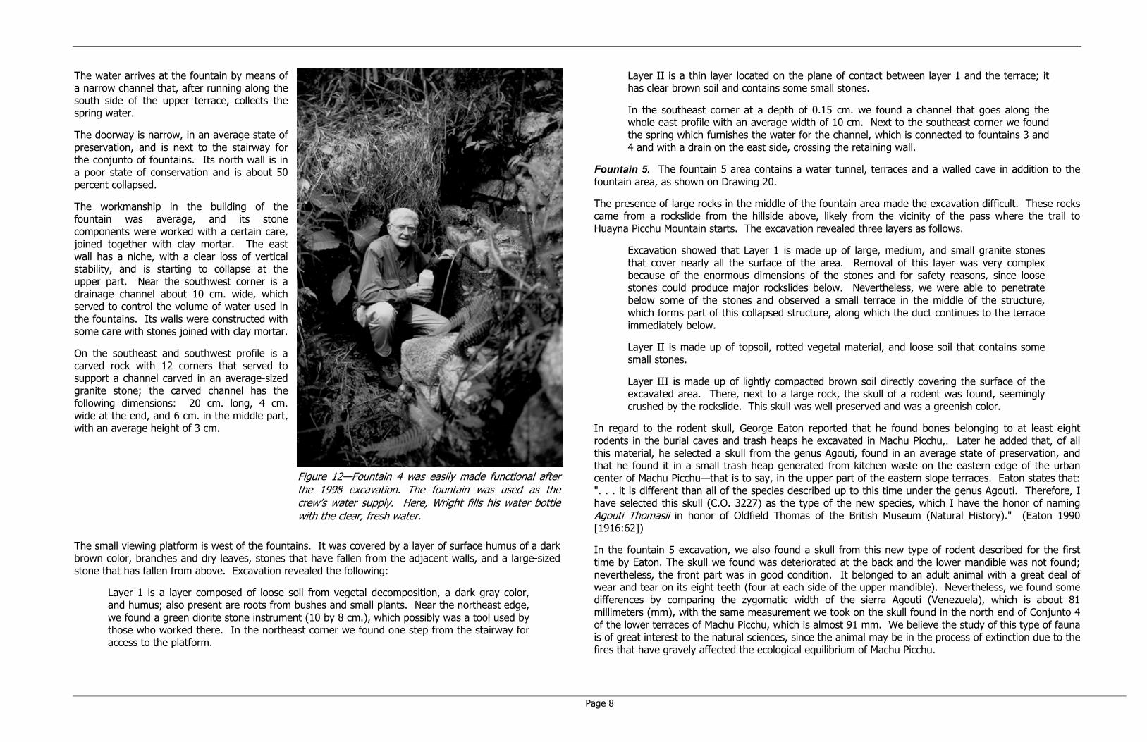
The water arrives at the fountain by means of a narrow channel that, after running along the south side of the upper terrace, collects the spring water.
The doorway is narrow, in an average state of preservation, and is next to the stairway for the conjunto of fountains. Its north wall is in a poor state of conservation and is about 50 percent collapsed.
The workmanship in the building of the fountain was average, and its stone components were worked with a certain care, joined together with clay mortar. The east wall has a niche, with a clear loss of vertical stability, and is starting to collapse at the upper part. Near the southwest corner is a drainage channel about 10 cm. wide, which served to control the volume of water used in the fountains. Its walls were constructed with some care with stones joined with clay mortar.
On the southeast and southwest profile is a carved rock with 12 corners that served to support a channel carved in an average-sized granite stone; the carved channel has the following dimensions: 20 cm. long, 4 cm. wide at the end, and 6 cm. in the middle part, with an average height of 3 cm.
Figure 12—Fountain 4 was easily made functional after the 1998 excavation. The fountain was used as the crew’s water supply. Here, Wright fills his water bottle with the clear, fresh water.
The small viewing platform is west of the fountains. It was covered by a layer of surface humus of a dark brown color, branches and dry leaves, stones that have fallen from the adjacent walls, and a large-sized stone that has fallen from above. Excavation revealed the following:
Layer 1 is a layer composed of loose soil from vegetal decomposition, a dark gray color, and humus; also present are roots from bushes and small plants. Near the northeast edge, we found a green diorite stone instrument (10 by 8 cm.), which possibly was a tool used by those who worked there. In the northeast corner we found one step from the stairway for access to the platform.
Layer II is a thin layer located on the plane of contact between layer 1 and the terrace; it has clear brown soil and contains some small stones.
In the southeast corner at a depth of 0.15 cm. we found a channel that goes along the whole east profile with an average width of 10 cm. Next to the southeast corner we found the spring which furnishes the water for the channel, which is connected to fountains 3 and 4 and with a drain on the east side, crossing the retaining wall.
Fountain 5. The fountain 5 area contains a water tunnel, terraces and a walled cave in addition to the fountain area, as shown on Drawing 20.
The presence of large rocks in the middle of the fountain area made the excavation difficult. These rocks came from a rockslide from the hillside above, likely from the vicinity of the pass where the trail to Huayna Picchu Mountain starts. The excavation revealed three layers as follows.
Excavation showed that Layer 1 is made up of large, medium, and small granite stones that cover nearly all the surface of the area. Removal of this layer was very complex because of the enormous dimensions of the stones and for safety reasons, since loose stones could produce major rockslides below. Nevertheless, we were able to penetrate below some of the stones and observed a small terrace in the middle of the structure, which forms part of this collapsed structure, along which the duct continues to the terrace immediately below.
Layer II is made up of topsoil, rotted vegetal material, and loose soil that contains some small stones.
Layer III is made up of lightly compacted brown soil directly covering the surface of the excavated area. There, next to a large rock, the skull of a rodent was found, seemingly crushed by the rockslide. This skull was well preserved and was a greenish color.
In regard to the rodent skull, George Eaton reported that he found bones belonging to at least eight rodents in the burial caves and trash heaps he excavated in Machu Picchu,. Later he added that, of all this material, he selected a skull from the genus Agouti, found in an average state of preservation, and that he found it in a small trash heap generated from kitchen waste on the eastern edge of the urban center of Machu Picchu—that is to say, in the upper part of the eastern slope terraces. Eaton states that: ". . . it is different than all of the species described up to this time under the genus Agouti. Therefore, I have selected this skull (C.O. 3227) as the type of the new species, which I have the honor of naming Agouti Thomasii in honor of Oldfield Thomas of the British Museum (Natural History)." (Eaton 1990 [1916:62])
In the fountain 5 excavation, we also found a skull from this new type of rodent described for the first time by Eaton. The skull we found was deteriorated at the back and the lower mandible was not found; nevertheless, the front part was in good condition. It belonged to an adult animal with a great deal of wear and tear on its eight teeth (four at each side of the upper mandible). Nevertheless, we found some differences by comparing the zygomatic width of the sierra Agouti (Venezuela), which is about 81 millimeters (mm), with the same measurement we took on the skull found in the north end of Conjunto 4 of the lower terraces of Machu Picchu, which is almost 91 mm. We believe the study of this type of fauna is of great interest to the natural sciences, since the animal may be in the process of extinction due to the fires that have gravely affected the ecological equilibrium of Machu Picchu.

Page 9
The water tunnel is large and was built beneath the terrace, reaching to the face of a large rock where the source of the spring water is located. It has a transversal quadrangular cross section and was built on a base of large stones, with enormous lintels in its upper part.
The water flow is irregular. In September 1999 the spring was completely dry, while in 1998 in the same season about 40 liters a minute of water were flowing. In 1998 water also poured out through a corner and upper part of the terrace located immediately below the water tunnel.
Immediately above the water tunnel and fountains is a small walled cave. Exploration allowed us to confirm that the rock serving as its base is the same as that found in the bottom of the water tunnel where the spring flows out. This cave is covered by a thick wall of granite stones with fitted joints and placed at the sides where the large rocks are located. These rocks are unstable; therefore, one of the reasons for building the masonry wall could have been to attain stability. This would have protected the spring located immediately below, the function of which was vital to the Incas. This assumption is reinforced by the fact that there is a backfill of gravel on the inside, which allowed filtration of rainwater.
Fountain 6. Fountain 6 is situated downhill at Station 0+75 on Drawing 4. It was not excavated. This fountain was flowing; the stonework has deteriorated. The fountain appeared to be a simple structure for use of a natural water source to provide a routine drinking water supply.
2.42 Hydraulics
Three notable features represent the hydraulic characteristics and care associated with the east flank Inca Trail:
1. Drainage channel and conduit for the Inca Trail located south of fountains 3 and 4.
2. Water tunnel of cut stones at fountain 5.
3. Channels of fountains 3 and 4.
The drainage channel and conduit south of fountains 3 and 4 represent special care taken to manage trail drainage near the midpoint of the Inca Trail.
The water tunnel at fountain 5 demonstrates the technology used in an effort to improve the reliability of the groundwater supply. This is exemplified with the presence of stone walls that form the tunnel with a flat cut slab roof. The height of the downstream portion of the water tunnel is estimated at 1.6 meters. Unfortunately, a rockfall has severely damaged the tunnel and has destroyed the fountain, leaving only a walled cave, tunnel remains, terraces and the damaged Inca Trail.
2.5 Hydraulic Innovation
Most notable are the two approach channels for fountains 3 and 4. Both approach channels were designed using the Venturi principle to improve flow characteristics of the water jet during low flow conditions. In fountain 4, the width of the channel decreases from 6.0 to 4.0 cm over a length of 20 cm, serving as a form of nozzle that causes the water velocity to increase, relating to a basic hydraulic formula of velocity = flow/area. Just upstream of the fountain 4 approach is a channel with a unique bifurcation built inside the wall so that excess flow is rejected to a wasteway that discharges into the adjacent drainage channel. During times of excess flow, the bifurcation allows the proper amount of water into the Venturi channel for optimum water jetting. The operating fountain is shown in Figure 12
2.6 Water Quality
The water quality of the fountains along the Inca Trail was determined to be good as shown in Table 2. The low dissolved solids that range from 36 to 56 mg/L represent the presence of only modest constituents, as would be expected close to the recharge area of the granite bedrock.
TABLE 2 East Flank Water Quality Sample Results from September 26, 1998
Parameters Tested Units Fountain 1 Fountains 3 &
4 Fountain 6
pH --- 7.0± 7.0± --- Flow L/min. 1-10 L/min. 8 L/min. 10 L/min. Inorganics Total Dissolved Solids mg/L 36.0 56.0 24 Total Alkalinity mg/L 9 16.2 NT1 Chloride mg/L <0.25 0.41 NT1 Sulfate mg/L <0.25 0.49 NT1 Dissolved Metals Sodium mg/L 2.6 3.1 NT1 Potassium mg/L U2 0.98 NT1 Calcium mg/L 1.4 3.0 NT1 Magnesium mg/L 0.35 1.3 NT1
1 NT = not tested. 2 U = not detected at the reporting limit.
2.7 River Hydraulics at Landing
The documented lower terminus of the Inca Trail shown on Drawing 2 is approximately 1.2 kilometers upstream of Mandor Pampa and about 1.5 kilometers downstream from the bridge at the abandoned Ruinas railroad station at a location where crossing on foot can be made during periods of low flow of the Vilcanota River (Figures 13 and 14).
The river discharge on September 26, 1999 was estimated to be 72 cms. The 1998-99 peak flow has been estimated at 230 cms. During the peak flow period of 1998-99, the original Inca protective wall was overtopped by the river water level by approximately 10 cm.

Page 10
Figure 13—Fording the Vilcanota River to the east flank Inca Trail landing on the right side of the photograph. River fording is not recommended due to hazards. A series of cascades lies downstream.
Figure 14—Stream cross section.
The primary natural features of the Inca river landing are as follows:
1. A large rock and earth debris deposit from the Huayna Picchu gully forms the left bank cove.
2. A boulder (0.6-meter-diameter) bar deposit at the base of the Inca Trail stairway provides flow protection to the landing during most of the year.
3. A steep river slope downstream terminating in several cascades creates supercritical flow velocities and a dampening of upstream water level functions, particularly during high flow periods.
4. The large rocks deposited at the base of the gully form a hydraulic control section immediately downstream of the landing. The control section provides benefits as follows:
- It limits the magnitude of river water level fluctuations.
- It creates a pooling phenomenon upstream.
5. A vertical wall cliff immediately upstream of the Inca landing helps to direct flow straight downstream by providing a deflection wall for the river currents. The vertical wall also provides for improved Inca Trail security control.
2.8 Trail Stability
The use of terraces for erosion protection and trail stability was evident in Conjunto 4 and Conjunto 6. The successful system of terracing at Conjunto 4 is illustrated in Figure 1, which is a view from the top of Huayna Picchu.
While not as concentrated as in Conjunto 4, terracing in Conjunto 6 is likely nearly continuous from the lowest gully to Cave 3. Here, the steep slope at the base of the Huayna Picchu cliff created a confined location for the trail with the cliff on the north and the steep drop-off to the river on the south.
2.9 Trail Summary Description
The Inca Trail is a magnificent work of engineering and old-fashioned workmanship performed with a high standard of care. It is a continuous whole; however, for presenting a trail summary description, it is divided into six parts as described below.

Page 11
wide 1 to 3 m wide1
to 3
m ta
ll±1m
NaturalGround
FillSoil
Small Rockfor Drainage
PlacedRocks
Trail Surface
A. Rough utilitarian stone work - not polished with tight fit.B. Mostly rock fill for bulk - chips of worked stone and material on hand.C. Fit landscape on probable foot paths - easiest route.D. Ramps, stairs and other pedestrian features used also.E. Wall or Revetment made up of stones 0.1 to 0.25m size typically.F. No weep drains - drainage through voids between stones.
SandGravel
For the purposes of this description, the reader should refer to the drawings attached that are at a scale of 1:100 and the large map at 1:1000 in the envelope at the rear of the report.
The reader should note that the description begins at Machu Picchu, although the survey starts at the river and proceeds uphill according to standard mapping practice. This is done to enable the reader to begin at a well-known point of reference. Therefore, the stationing for locations is from 14+50 at the qolqas to 0+00 at the river.
Figure 15—Typical section of Inca Trail on the East Flank of Machu Picchu..
2.91 The First Section (Qolqas at 14+50 to Inca House at 13+00)
Between 14+50 and 13+50 most of the trail is well known and long established as shown on the large map and on Drawings 34 to 36. The long and steep granite staircase is sturdy and well constructed. This first section goes to the Inca building at Station 13+00 (Control Wayrona) that is preserved only to a height of 0.5 meters.
This enclosure (Figure 16) has a somewhat irregular rectangular plan with a length of 5.0 meters and a width of 2.7 meters. The walls are 0.50 meters wide. It has a rock for support of its back wall, where there also is a cave. There is no evidence of a front wall, so likely it was a wayrona, such as those seen along all the Inca trails between Huayllabamba and Machu Picchu. There is no evidence of any niches or windows either—probably due to the poor state of preservation.
This small enclosure is adjacent to and above the Inca Trail. In 1998 we found a stone peg nearby as evidence of a double-sloped roof, as well as a short stretch of stairway, which indicates that the original trail passed below this building.
Figure 16—Crew at Inca Building below Conjunto 13 that served as a central wayrona (see Drawing 34).
The stone elements of the long granite staircase are granite blocks in an irregular parallelepiped form. Each step consists of three to five carefully placed stones—sometimes a large stone and another smaller one together. Steps vary in accordance with the slope of the terrain. There are wide ones from 35 to 40 cm with a similar height and with very narrow surfaces where, at times, one can only place a foot sideways. One also encounters short ramps or inclined planes.
The function of this section of the trail is to connect the main trail with the urban center of Machu Picchu and for control of access from the trail adjacent to the Inca building previously described.
2.92 The Second Section (13+00 to 10+88)
Between the Inca House and the stairway is the beginning of a short trail to a small conjunto of terraces, which we called 3A. This small conjunto of terraces consists of some 12 terraces connected by means of “sarutas” or long stones cantilevered out from the walls of each one of the terraces (sometimes called "flying stairways"). At the foot of the lower terrace is an old pathway that joins the exterior outer wall of the lower east flank Conjunto 1 with Conjuntos 3 and 4, which were explored in previous years.
Down the trail from the Inca House is a spiral staircase (12+75 to 12+50) with four turns. Then, at 11+50, there is a long rock paved ramp with a buttress wall on the north side. A Grand Staircase of 10 steps is located at 10+92 which is 4 meters long, 1.40 meters high, and 1.78 meters wide. The steps have an average height of 0.30 meters, and the stairway is made up entirely of large stone elements, nearly monolithic. The large blocks are well set, and it seems that the stones have been fitted using a clay mortar, which has almost disappeared through erosion. (See Drawings 30 to 34 for details and an overview on the large-scale map in the pocket.)

Page 12
2.93 The Third Section (10+88 to 8+60)
Section 3 of the Inca Trail goes from the Grand Staircase to Conjunto 4; it is shown on Drawings 24 to 30.
After coming down the Grand Staircase, one arrives at a large ramp at 10+47. It is constructed with a retaining wall with flat well-seated rocks. This inclined plane is in a good state of preservation and represents good Inca engineering.
In the lower part of the ramp there is an old rockfall which has caused serious destruction of part of the trail. One also sees enormous rocks covered with vegetation of lianas and evidence of broken trees, which indicate that this rockfall occurred some 10 to 20 years ago. A narrow gully follows the rockfall.
Then at 10+11 is a branch trail to the west that represents a possible connection to the area of the Sacred Rock; however, the branch trail remains unexplored.
At 9+72 begins a unique “S” staircase to 9+55 that seems to be laid out with engineered curves with individual steps carefully positioned to form smooth curves. From this point, the trail descends in a straight manner by a narrow stairway in a poor state of preservation until it arrives at the site of a group of enormous terraces that form the central part of Conjunto 4 at Station 8+61.
Figure 17—Alfredo Valencia, Ken Wright and Ruth Wright on the S-staircase near Station 9+65.
Some meters above Conjunto 4 (at 9+00) on the north side, there is an excavation 2.50 by 2.50 meters with a depth of 1 meter. It is difficult to pinpoint its cultural affiliation. It could be an incomplete Inca work or an excavation by the Bingham party from 1912.
2.94 The Fourth Section (8+60 to 7+28)
This fourth section extends between Station 8+60 at Conjunto 4, passing by Fountains 3 and 4 to Conjunto 5. This section is shown on Drawings 20 to 24. It is an extraordinary sample of Inca engineering and the best preserved of the whole trail. This trail extends along the upper west side of the terraces of this conjunto following a pathway approximately from east to west. The trail runs between two extensive terraces, with an average width of 2 meters and steps some 2.80 meters wide. It connects fountains 3 and 4 to fountain 5 found at the west end of Conjunto 4. The WWE Machu Picchu paleohydrological survey project described this area in detail in a report to the INC dated October 1998.
One of the stairways on this trail has nine steps—the upper one being 3.3 meters wide with a height of .25 cm. It is made of carefully placed stones. For example, the lower step has a tread of 0.40 cm, a height of 0.26 cm, and consists of five well-placed stones. This section of the trail can be described as magnificent with three fountains and a viewing platform with one of the finest views one could expect (see Frontispiece).
2.95 The Fifth Section (7+28 to 3+40)
This section extends between fountain 5 at the north end of Conjunto 4 at Station 7+28 to Cave 3 (Drawing 13) of Conjunto 5 at Station 3+40, as shown on Drawings 9 to 20. It connects Conjunto 4 with Conjunto 5. At Station 7+00, a double retaining wall some 19 meters long begins, followed by 93 meters of survey line where there was no evidence of the trail. Then, at Station 5+87, the trail is again evident with 10 staggered boulder steps, and at Station 5+76 a double retaining wall again appears above the trail. Seven meters further downhill commences a 38-meter-long section of random boulder placement at Station 5+60.
Figure 18—Curved retaining wall at Cave 3 near Station 3+14 (see Drawing 9).
Uphill of the survey line at Station 5+10 is a rockslide that is considered hazardous. Beyond the rockslide and after a 2-meter-high wall one comes to Cave Two at Station 4+60. This cave has a trapezoidal floor plan, and three of its interior sides have been almost entirely covered in fine masonry. One also sees small niches and several loose carved stones on the interior. Some sections of the wall have been destroyed. The details of Cave Two and its terraces are shown on Drawing 9.
From Cave Two the survey route descends the steep hillside north of the terrace Conjunto 5 that Dr. Valencia documented in 1969, which is partially shown on Drawing 11.
At Station 4+27, the survey route and the trail take a sharp right angle bend to the north, where they lead to the cathedral-like Cave Three at Station 3+40. Cave 3 has a rectangular floor plan and is limited along the east by means of some terraces and along the south by a conjunto of medium-sized rocks; along the north and west sides one sees the granite massif fissure, which seems to be a geologic fault. On its interior, there are two large carved rocks placed in a manner of large seats. One of them has a

Page 13
stepped form on one of its sides; the other is rectangular. From here one has a marvelous view of the narrow Vilcanota canyon, the base of Putucusi Mountain, and part of Mandor Pampa. A highlight of the Cave Three area is the curved wall that is 2 meters high with a near perfect radius of 21 meters. The wall was not completely cleared and, therefore, the survey and map do not show the curved wall in its entirety.
Figure 19—The 1999 Trail Exploration Team at Cave No. 3.
2.96 The Sixth Section (3+40 to 00+00)
Downhill from Cave Three are five terrace walls commencing at Station 2+80. The walls are well constructed and in good condition, as shown on Drawings 2 to 9. This is an impressive set of terraces that we named Conjunto 6. It is believed there are many terraces not yet cleared and surveyed that lie under the forest.
The trail lies at the base of the Huayna Picchu cliff for some 120 meters until Station 1+50 where there are additional terraces and a 15-meter-long earth ramp that leads to an elaborate area of construction south of a Huayna Picchu gully.
The complex of terraces, fountain 6, and an in-situ monolithic carved stairway lie between stations 1+30 and 0+50, as shown on Drawing 4. The monolithic stairway was completely covered with vegetation and soil. After clearing work, we verified that it has 14 steps. This portion of the trail is one of the most fascinating because of the challenges faced by the Inca engineers.
Finally, at the base of the trail (Station 0+00) are the remains of a stairway and wall that have been subject to the ravages of time and the forces of the Vilcanota River during periods of flood.
It is likely (but no evidence exists) that the trail continued downstream along the left bank of the Vilcanota River several hundred yards to a potential Inca bridge crossing.
Figure 20—Chris Crowley examining the remains of an Inca wall at the River Landing (see Drawing 2).
Figure 21—Floor plan of the old Arteaga dwelling place at Mandor Pampa situated on the right bank of the Vilcanota River across from the base of Huayna Picchu.

Page 14
3.0 MANDOR PAMPA AND THE ARTEAGA DWELLING PLACE
On September 11, 1999, the banks of the Vilcanota River were explored as far as Mandor Pampa, where Lorenzo Alagon Santos and his wife, Angelica Jauregui de Alagon, were interviewed. They asked one of the farm workers to take us to "Arteaga's house." Hiram Bingham indicated that he passed by the vicinity of a hut with a straw roof, whose owner was Melchor Arteaga. This hut, in its turn, was a kind of inn for the occasional travelers who passed by the site. Bingham indicates that “At dawn on July 24, 1911 there was an icy rain…when we asked him where the ruins were, he pointed directly toward the top of the mountain…I left the tent at 10:00 in the morning.” (Bingham, 1930)
The Arteaga dwelling place at present is in a state of ruin. Its floor plan is in the form of a rectangle with two doorways. It is 9.9 meters long and 5.2 meters wide with a preserved height of one meter. The wall has an average width of 70 cm and has sloped walls. The dimensions of the building, fragments of pre-Hispanic ceramics, finely worked and carved stones, and a stone mortar led to the exciting conclusion that Arteaga's house was an Inca building (Figures 21 and 22).
Figure 22—Ruth Wright at Mandor Pampa with the wall of the Arteaga dwelling place.
4.0 SUMMARY OF THE MACHU PICCHU TRAILS
The east flank Inca Trail of Machu Picchu is associated with a vast network of other Inca trails.
4.1 The Main Trail (“Hatan Ñan”) Cusco—Machu Picchu
The trail from Cusco to Machu Picchu went northwest past the Pampa de Anta and continued to the Qollpa sites, Huayllabamba, Runkuraqay, Phuyupatamarca, Sayacmarca, Wiñay Wayna, Intipunku and Machu Picchu. This main trail was the easiest and most direct route to Machu Picchu from Cusco.
4.2 The Inca Bridge Trail
The Inca Bridge Trail’s last section before Machu Picchu is along the precipices on the west side of Machu Picchu Mountain (Figure 23). There is a gap at the bridge. This trail joins with the main trail 90 meters from the main entrance to Machu Picchu and connects Machu Picchu with the Inca terraces found at the bottom of the river valley in the vicinity of San Miguel.
Figure 23—Agricultural Terraces and the Guardhouse, The trail going to the left leads to the Intipunko and Cusco, the stairs on the right lead to the Inca Bridge.
4.3 The San Miguel Bridge Trail
The trail arrives at Machu Picchu by means of narrow stairways southwest of the Temple of the Three Windows. Discovered after a forest fire some years ago, it joins the left bank of the Vilcanota River on the southwest flank of Machu Picchu. It is very steep, and along its path architectural evidence and burial goods have been found.
4.4 Lower East Flank Trail
The zigzagging city wall protects the main archaeological monument along its east side. It has two doorways: one in the vicinity of conjunto of enclosures “E” to the southwest of the lower agricultural sector and another in the vicinity of Conjunto No. 1 of the lower east flank terraces. This doorway permitted direct access from the lower terraces to the exterior part of Machu Picchu. It likely allowed pedestrian access to the river terraces, found on the banks of the Vilcanota River, as well as to the Inca Trail in this area.
The lower portion of the trail was nearly completely destroyed by the Hiram Bingham highway. (See Figure 4.)

Page 15
4.5 Trail From the Left Bank of the Vilcanota River
The trail is relatively short due to the topographical condition of the terrain since, at the foot of the mountain where Machu Picchu was built, there are nearly vertical precipices, mostly across from the present day town of Aguas Calientes as well as downstream from the present site museum. This trail was accessible from the right bank of the Vilcanota River by means of two Inca bridges.
One of these bridges was upstream from the present metal tourist bridge, and the other probably was further upriver.
The trail on the left bank of the Vilcanota River connects the agricultural terraces on this bank as well as those found in the vicinity of the present site museum. From here one has access to the upper part of Machu Picchu following the trail from the east flank previously discussed.
4.6 Trail on the Right Bank of the Vilcanota River
This pathway is one of the most important of the Machu Picchu trails. It is likely that it united Ollantaytambo and Machu Picchu, passing by Piscacucho, Salonniyoq, Kanabamba, etc. until it arrived at the terrain presently occupied by the Town of Aguas Calientes (ancient site of La Maquina). From there, it likely continued behind the rocky summit of Putucusi (Media Naranja) or along the bank of the river at least as far as Mandor Pampa. (See Figure 5.)
4.7 Trail To the Temple of the Moon
This trail begins in the conjunto of the Sacred Rock. Here two longitudinal trails join together: the trail from the west and one from the east.
The trail to the Temple of the Moon crosses a narrow ridge that separates the large rocky mass of granite. At a medium altitude, the trail bifurcates into two branches: one continues to the Temple of the Moon, and the other ascends by means of a narrow stairway to the summit of Huayna Picchu.
The trail is narrow and, due to the roughness of the rocky massif, crosses deep precipices past carved rock. This trail permits access to a large, cavernous enclosure, in whose interior fine expressions of Inca architecture have been constructed. Just beyond are a very tall double-jamb doorway and other structures. The trail may continue to other points before arriving on the left bank of the Vilcanota River.
4.8 Trail to Huayna Picchu
This trail is almost totally a large stairway with narrow, dangerous steps (Figure 24). After allowing passage through a small tunnel nearly at the summit, it permits access to the summit of this mountain. Here one sees several enclosures as well as passages and stone stairways.
From this point one sees a wonderful landscape. Toward the south one sees Machu Picchu Mountain. In the foreground the archaeological site of Machu Picchu is seen with its great plaza, different conjuntos and sectors. Toward the west one sees the deep San Miguel Valley. Toward the north appears the Vizcacha Mountain and, further off, the high mountain known as Apucatintin and several snowy peaks. To the northeast arises the rounded summit of Putucusi.
5.0 POLLEN SAMPLE COLLECTION PROGRAM FOR MACHU PICCHU AGRICULTURAL TERRACES
The pollen field-testing program at Machu Picchu was conducted in two phases: one in September 1998 and the second in September 1999. The 1998 phase occurred on the lower east flank terrace of Conjunto
No. 1 near Fountain 1. The 1999 phase was on the main agricultural terraces of Machu Picchu at four locations from south to north.
5.1 1998 Pollen Samples
Three soil samples were collected on September 26, 1998 at a single location (Test Site 1) on the third terrace above and 30 meters east of fountain 1 on the lower east flank about one-third the distance down to the river at an elevation of about 2,250 meters. The soil sample contained three parts: (a) surface to a depth of 5 cm, (b) 5 cm to 15 cm, and (c) 15 cm to 20 cm.
5.2 1999 Pollen Samples
Four pollen sample sites were selected on September 15, 1999 in conjunction with Instituto Nacional de Cultura (INC) personnel including Machu Picchu Manager Wilfredo Yeped Valdez (Figure 25).
The soil samples were from original Inca terrace surfaces as judged by INC personnel and Dr. Valencia. The sample locations represent widely divergent areas from south to north and from varying elevations ranging from about 2,520 meters at the south to 2,400 meters at the Site No. 5 location to the north.
The first 1999 samples (Site 2) were collected from a terrace located to the northeast and on the lower side of the main trail located in the high agricultural sector of the Machu Picchu. The second set of samples (Site 3) was collected from a terrace located in the middle of the lower agricultural sector. The third set of samples (Site 4) was extracted from a terrace located in the middle part of the lower agricultural sector. The fourth set of samples (Site 5) was from a short narrow terrace located at one side of the first stretch of the stairway that leads to the terraces on the east flank. For each sample location, the shallowest sample is designated as A and the deepest as C.
Figure 24—Sturdy and well-constructed stairways near the summit of Huayna Picchu.

Page 16
Site 2—Southerly sample near the Inca Site 3—Sixty meters northeast of the Guardhouse. Trail, 182 meters from the Guardhouse
Site 4—Eighty meters southeast of the Temple Site 5—Terraces 77 meters north of Intimachay. of the Sun.
Figure 25—Pollen Sample Locations collected in 1999 at four divergent locations representing a variety of terraces at Machu Picchu. The 1998 sample location was on a terrace in lower east flank Conjunto 1 near the outer wall.
6.0 POLLEN TESTING RESULTS
Dr. Linda Scott Cummings conducted the pollen analysis at the PaleoResearch Laboratory of Golden, Colorado (Wright, Wright & Cummings 2000).
Although the pollen record is complex with a wide variety of pollen types recovered from the soil samples (Figure 26), this report focuses on only a portion of the record. The dominant element of the pollen record is grass pollen, reflecting the modern growth of grasses on the agricultural terraces. An abundance of grass is substantiated by examination of these sediments for phytoliths. Phytoliths were extremely abundant and thoroughly dominated by silicified grass short and long cells (Figure 27).
Interpretation of the pollen record for evidence of typical trees, shrubs, herbs and lianas expected in the High Andes is left for later publication. Here we focus on evidence for agricultural crops along with plants that might have been harvested for medicinal use (Figure 28).
In the modified pollen diagram (Table 4), one can see evidence of a variety of plants that might have been grown as agricultural crops and others that might have been present either intentionally or as part of the weedy plant complex. An important assumption in interpreting this pollen record is that pollen recovered from these terraces represents plants grown on the terraces or pollen transported by the wind from surrounding vegetation. It is important to discard the potential for water transport of pollen from one terrace to another that would smear the pollen record from the top terraces along the lower terraces. WWE studied the terraces and determined that there was no irrigation and that infiltration capacity was so high that surface runoff was not significant (Wright, 1999).
The most important pollen type recovered in the samples is that of Zea mays, representing cultivated maize. Maize pollen was recovered in 14 of 15 samples examined and was absent in the uppermost sample (5A) from Site 5. It was least abundant in Hole 4, where it was recovered during the scan of each sample, but not in the count. Each sample was scanned at low power looking for evidence of maize, other larger pollen starch granules or other evidence of agriculture.
Recovery of maize pollen from all of the agricultural terraces examined supports the theory that maize was grown at Machu Picchu, likely for making chicha (the ceremonial beer). Recovery of maize pollen in these samples should propel field research into the storage of maize and examination of probable chicha vessels or vessel fragments for phytolith evidence of chicha production. As reference databases expand, we expect to use this technique to identify specific races of maize used at Machu Picchu.
Plants that might have been exploited for their medicinal properties, whether grown intentionally or used as part of the natural vegetation include walnut, Apiaceae, various members of the composite and mustard families, celedonia, paico or cañihua, pega pega, various members of the mint family, various grasses, sambo corota, members of the rose and scroph families, nettle (ortiga), and aloe (saliva).
Evidence for growth of other plants on the Machu Picchu agricultural terraces includes the presence of a legume in the lowest sample (1C) from Site 1. This hook-shaped hair might be from cultivated beans. In addition, potato-type starch granules were recovered from Site 1, suggesting that potatoes were grown on this particular remote terrace. Therefore, total evidence for agricultural plants on this terrace includes maize, potatoes and a legume, potentially cultivated beans. Members of the mint family also grew on this terrace, perhaps intentionally.

Page 17
1A
1B
1C
2A
2B
2C
3A
3B
3C
4A
4B
4C
5A
5B
5C
Hole 1
Hole 2
Hole 3
Hole 4
Hole 5
4479
550
11630
448
2280
25335
2871
12667
18275
13057
51171
10556
8529
3936
4557
51
101
51
102
100
99
101
100
116
100
100
100
SAM
PLE
NO
.
AR
BORE
AL
POLL
EN
Aln
usBO
RA
GIN
ACEA
Ecf
. Br
ouss
onet
ia (
dipo
rate
)Ju
glan
sM
ALPI
G D
inem
andr
a-ty
pePA
LMA
EPi
cea
Pinu
sO
rites
(PR
OTE
ACEA
E sp
iny)
RU
BIAC
EAE
cf. R
elbu
nium
cf.
Rubi
aR
UTA
CEA
E (r
ound
er)
Zant
hoxy
lulm
-typ
e
cf.
Xylo
sma
API
ACEA
EA
rtem
isia
HIG
H-S
PIN
E A
STER
ACEA
E
LOW
-SPI
NE
ASTE
RA
CEAE
BRA
SSIC
ACE
AEBR
ASS
ICA
CEAE
CLA
VATE
-TYP
E
Cal
andr
inia
-typ
eC
ARYO
PHYL
LACE
AEC
HEN
O-A
MA
ltern
anth
era-
type
Cle
ome-
type
CYP
ERAC
EAE
Des
font
aine
aEp
hedr
a to
rrey
ana-
type
FABA
CEAE
cf.
Des
mod
ium
(pe
ga p
ega)
Mim
osa
GU
NN
ERAC
EAE
Ipom
oea
LAM
IACE
AELA
MIA
CEAE
5 C
OLP
ILA
MIA
CEAE
Cum
inia
-typ
eLo
nice
ra-t
ype
(4c)
MAL
VAC
EAE
Myz
oden
dron
-typ
eO
NA
GR
ACEA
EPO
ACEA
E
POLE
MO
NIA
CEAE
CLA
VATE
Mon
nina
Poly
gala
RO
SAC
EAE
SCR
OPH
ULA
RIA
CEAE
Urt
ica-
type
Alo
eFA
BACE
AE (
3P)
FABA
CEAE
? W
/LIP
SFA
BACE
AE-T
YPE
HO
OK-
SHAP
ED H
AIR
cf.
Pers
eaPh
ysal
is/S
olan
umcf
. Ti
lland
sia
Zea
may
sIN
DET
ERM
INAT
EFi
ne r
etic
ulat
e 3T
?TC
P ro
und
pore
27
uTC
P Sm
all R
etic
ulat
eTC
P tin
y w
/ ro
und
pare
Tiny
TCP
sm
ooth
Uni
dent
ified
TP
psila
te c
a. 4
0 m
icro
nsD
ot s
tarc
hH
orde
um-t
ype
star
chSo
lanu
m-t
ype
star
chSt
arch
ang
ular
w/
hilu
m
STAR
CH H
OLL
OW
TOTA
L ST
ARCH
AST
ERAC
EAE
TISS
UE F
RAG
MEN
TPO
LLEN
SUM
TOTA
L PO
LLEN
CO
NCE
NTR
ATIO
N
HO
LE N
O.
101
100
104
RUTACEAE ASTERACEAE CHENO-AMS FABACEAE LAMIACEAE POLYGALACEAE cf. AGRICULTURAL STARCHES
Figure 26—Profile of Soil Samples.
Figure 27—Pollen diagram, soil samples collected by Wright Water Engineers, analyzed by Linda Scott Cummings.
SAMPLE 2-A SAMPLE 3-A
SAMPLE 5SAMPLE 4
DEPTH
0 - 5 cm
5 - 15 cm
15- 25 cm
0 - 5 cm
5 - 15 cm
15- 25 cm
HUMUS LAYER
LOOSE SOIL GRAVELS
COMPACTED SOIL
DEPTH

Page 18
Figure 28—Modified pollen diagram, soil samples collected by Wright Water Engineers, analyzed by Linda Scott Cummings.
Site 2 yielded evidence of cultivation of an unidentified legume (identified by comparison to a reference specimen collected in Peru, but identified only to the family level at this time) and maize. A member of the mint family was present, as was a plant known locally as pega pega (Desmodium).
Site 3 exhibits evidence of cultivation of maize. Again, members of the mint family and pega pega were present. This terrace yielded the most evidence for the mint family.
Site 4 yielded little evidence of agriculture. Maize was recorded only during the scan of the sample, and mint family pollen was present in small quantities.
Site 5 contained the most diversity in the pollen record of plants that might have been grown on the terraces sampled. In addition to maize, aloe, an unidentified member of the legume family, perhaps avocado, potatoes and qaqa suncja pollen suggest cultivation of these plants. Pega Pega also was present. The diversity of the pollen record suggesting agriculture in this area hints that a wide variety of plants may have been cultivated at Machu Picchu.
This first pollen record obtained from the agricultural terraces of Machu Picchu indicates that much of the terrace system could have been used to grow maize at any one time. Perhaps crops were rotated on some (or all) of the terraces, resulting in mixed pollen signals. Certainly this analysis points to growth of maize at Machu Picchu. We are now left with the task of identifying what varieties of maize were grown here by sampling chi cha vessels and maize cobs for phytoliths, as well as sampling additional terraces such as at the Intiwatana pyramid to identify other plants grown on the terraces, including those with medicinal uses.
7.0 FLORA OF MACHU PICCHU
In addition to agricultural products, the pollen samples from Machu Picchu represent many types of flora. However, the flora pollen of special interest found in the Machu Picchu soil samples are shown in Table 3.
From the original scan and study of pollen samples, 12 standout species known to inhabit Machu Picchu and known to possess special properties are identified with their uses (Table 4).
Many references were used to obtain the lists, nomenclature, and descriptions for Tables 3 and 4. These references are listed in the bibliography section by authors.
Figure 29—Flor del Inca (Polmoniacea).
1A
1B
1C
2A
2B
2C
3A
3B
3C
4A
4B
4C
5A
5B
5C
Hole 1
Hole 2
Hole 3
Hole 4
Hole 5
4479
550
11630
448
2280
25335
2871
12667
18275
13057
51171
10556
8529
3936
4557
51
101
51
102
100
99
101
100
116
100
100
100
101
100
104
SAM
PLE
NO
.Cf
. Bro
usso
netia
(di
pora
te)
Jugl
ans
APIA
CEAE
Arte
mis
ia
HIG
H-S
PINE
AST
ERAC
EAE
LOW
-SPI
NE
ASTE
RACE
AEBR
ASSI
CACE
AE
BRAS
SICA
CEAE
CLA
VATE
-TYP
E
CARY
OPH
YLLA
CEAE
CHEN
O-A
M
Cleo
me-
type
FABA
CEAE
cf. D
esm
odiu
m (
pega
peg
a)
GUN
NERA
CEAE
Ipom
oea
LAM
IACE
AE
LAM
IACE
AE 5
CO
LPI
LAM
IACE
AE C
umin
ia-t
ype
MAL
VACE
AE
POAC
EAE
Mon
nina
ROSA
CEAE
SCRO
PHUL
ARIA
CEAE
Urt
ica-
type
Aloe
FABA
CEAE
(3P
)
FABA
CEAE
? W
/LIP
S
FABA
CEAE
-TYP
E H
OO
D-S
HAP
ED H
AIR
cf. P
erse
a
Phys
alis
/Sol
anum
cf. T
illan
dsia
Zea
may
s
Hor
deum
-typ
e st
arch
Sola
num
-typ
e st
arch
Star
ch a
ngul
ar w
/hilu
m
POLL
EN S
UM
TOTA
L PO
LLEN
CON
CEN
TRAT
ION
HO
LE N
O.
ASTERACEAE LAMIACEAE cf. AGRICULTURAL

Page 19
TABLE 3 Pollen at Machu Picchu
TREE POLLEN SHRUB POLLEN BETULACEAE—Birch family RUBIACEAE—Madder family Alnus spp. Rubia spp. ANACARDIACEAE—Sumac family RUTACEAE—Citrus family Schinus molle Zanthoxylum spp. BORAGINACEAE—Borage family Xylosmia spp. Broussonetia spp. ASTERACEAE (Sage)—Sunflower family JUGLANACEAE—Hickory family Artemisia spp. Julglans spp. PROTEACEAE—Protea family Orites spp. PALMAE—Palm family PINACEAE—Pine family Picea spp. Pinus spp. APOCYNACEAE—Dogbane family Rauwolfia spp.
FLOWER POLLEN
ASTERACEAE—Sunflower family MALVACEAE—Mallow family High Sphaeralcea spp. Low LEGUMINOSAE—Pea family BRASSICACEAE—Mustard family Mimosa spp. Calandrimia spp. ONAGRACEAE—Evening primrose family CARYOPHYLLACEAE—Carnation family Fuchia spp. Alternanthera spp. POACEAE—Grass family CAPPARARIDAEA—Caper family Poa spp. Cleome spp. POLEMONIACEAE—Phlox family CYPERACEAE—Sedge family Cantua spp. Desfontainea spp. POLYGONACEAE—Knotweed family EQUISETACEAE—Horsetail family Monina spp. Equisetum spp. ROSACEAE—Rose family Ephedra spp. Kageneckia spp. FABACEAE—Pea family SCROPHULARIACEAE—Figwort family Desmodium spp. URTICACEAE—Nettle family Persea spp. Urtica Spp. GUNNERACEAE Aloe vera CONVOLVULACEAE—Morning glory SOLANACEAE—Nightshade family family lpomoea spp. Solanum spp. LAMIACEAE—Mint family BROMELIACEAE—Pineapple family Stachys spp. Tilladsia spp. CAPRIFOCIACEAE—Honeysuckle GRAMINAE family Loniceria spp. Zea mays APIACEAE—Parsley family Cuminium spp.
Figure 30. The rare Spectacled Bear photographed high above the Machu Picchu Tourist Train.

Page 20
TABLE 4 Plants Identified as Potential Species in Pollen Testing at Machu Picchu
Common English Name
Common Cheehua
Indian Name
Common Family Name
Scientific Name Scientific Family Name Special Properties and Uses
Wild potato Papa Nightshade family Solanum spp. SOLANACEAE Edible tuber; 138 genus in Peru --- Molle Sumac family Schinus molle ANACARDIACEAE Dark green dye; ingredient in checha beer; sweetener --- Monina and
Sambo Corota Knotweed family Monina crotal-
arioides POLYGONACEAE Dandruff control; grows hair; edible fruits; blue dye
Aster Flora buena Sunflower family Aster spp. ASTERACEAE Petals used as a laxative, dyes for skin painting (water soluble); petals used in adornment of hair and necklaces, flowers for rituals; most common cultivar in Peru
Groundsel Kinsa Kucho Sunflower family Baccharis genistelloides
ASTERACEAE Urinary tract infections; malaria; treatment for fever; rubbed as poultice for rheumatism
--- Lloque Rose family Kageneckia lanceolata
ROSACEAE Black dye; wood for tools; tans leather; antimalarial
Mint Hierba de Cancer
Mint family Stachys bogotensis LAMIACENE Anti-infection poultice applied to open wound; mint/herb
Primrose Fuxia Evening primrose family
Fuchia boliviana ONAGRACEAE Baths for skin irritation, mild burns, dermatitis
Inca flower Flor de Inca Phlox family Cantua buxifolia POLEMONIACEAE Frequently depicted in art; sacred flowers of the Inca God of the Sun; yellow dye; branches used to build baskets Bee plant --- Caper family Cleome spp. CAPPARARIDAEAE Used as a black pigment on pottery and cloth; tea used to relieve stomach disorders Scour rush Cola de
Caballo Horsetail family Equisetum
bogotensis EQUISETACEAE Scouring plant; scrubs skin smooth; smoothes wood and clay, urinary tract infection (also known as Ephedra
americana in Peruvian texts) Maize Choclo --- Zea mays GRAMINAE Vitamins for muscles; good for the brain and nervous systems; used to make checha beer

Page 21
8.0 FAUNA
Fauna of Machu Picchu include the Mayu Puma (river nutria), serpents, rock hens, hummingbirds, ground snails, bats, lizards, coleopteras (beetles), grasshoppers and dragonflies. During the Machu Picchu east flank trail exploration, vizcachas (Lagidium peruvianum), Spectacled bear (Figure 30), a large variety of butterflies, deer, mountain turkey and capizo were noted along with a large variety of birds, serpents, many ants and spiders.
Figure 31—Ceremony to the "Inca gods" at the conclusion of the exploration and mapping of the Zegarra-Wright Trail.
9.0 FUNCTION OF THE INCA TRAIL ON THE EAST FLANK OF MACHU PICCHU
The east flank Inca Trail of the 1998-99 archaeological exploration is the continuation of the main trail which joined Cusco with Machu Picchu and which continued to Mandor Pampa, joining with the Inca Trail on the right bank of the Vilcanota River in such a way that one could continue on downriver as far as the deepest part of the jungle. Likewise, one could return to the upper part of the valley as far as Cusichaca, Ollantaytambo or Cusco by another route.
The Inca Trail which joins Conjunto 11 (Qolqas) in Machu Picchu with the left bank of the Vilcanota River has several branches like the one leaving from Conjunto 4, which went toward Conjuntos 1, 2 and 3, and the entrance, which faced the trail on the east flank. One also sees other small branches that connected the main trail, by means of stairways, with several sectors of each of the conjuntos of terraces.
It also fulfilled a ceremonial and sacred role since it joined the Machu Picchu urban sector with two burial groups. The first group was located northeast of the point where the east flank trail begins at the stairway to the qolqas, where Hiram Bingham found tombs 1, 2, 3, 4, 5, 6, 7, 8, 13, 14, 15, 16, 45, 47 and 48. Mr. Bingham found the second group to the southeast of this same former point. The second group was made up of tombs 28 through 40 (Figure 5). The caves, which are found along the trail, may correspond to the structures of some of these tombs.
By way of example, Eaton indicates in regard to tomb 1: “The first burial site visited was an artificial cave below a large cliff, near the trail descending from the side of the mountain and to the northeast of the ruins. . . .” (Eaton, 1990 [1930]: 5.) This undoubtedly refers to the beginning of the trail which we have documented. The structure was a cave found below a large rock, whose entrance is in the form of a triangle, protected by means of a rock wall. The skeleton (found in a flexed position) was that of a woman approximately 35 years old. The associated burial goods consisted of two pots with pedestals that Mr. Bingham described as beaker shaped (Bingham, 1930: 119). The pots were stained with pot black—evidence of their use in cooking.
This trail filled an important economic function by connecting the six large conjuntos of agricultural terraces and other smaller ones, assuring the cultivation and harvest of useful food plants such as corn, potatoes, and likely beans. It also assured the provision of water by means of five springs along the main trail and its branch trails located in Conjuntos 1, 3, 4, and 6 and by providing easy direct access to the river below.
10.0 AUTHORITY, PERSONNEL, AND PROCEDURE
10.1 Authority
The authority for the archaeological exploration is represented by the four attached documents as follows:
1. 1994 Permit.
2. Letter from Gustavo Manrique Villalobos, Director General of the Instituto Nacional de Cultura.
3. 1998 Pollen Permit.
4. Opinion No. 129-99-INC-C/CTCPAA dated October 6, 1999.

Page 22
10.2 Personnel
Personnel included the following:
Kenneth R. Wright Director and Chief Engineer
Dr. Alfredo Valencia Zegarra Chief Archaeologist
Ives Bejar Mendoza Deputy Archaeologist
Christopher M. Crowley Engineering Surveyor
Scott A. Marshall Engineering Surveyor
Ruth M. Wright Historian and Photographer
Patricia A. Pinson Document Control
Dr. Gordon McEwan Scientific Advisor
10.3 Procedure
The methodology employed for the archaeological exploration included the systematic search for archaeological evidence through the study of aerial photographs and maps from the INC, examination of the specialized bibliography, physical exploration and confirmation on the ground from evidence presented by the Inca Trail. The written archaeological record consisted of graphics (sketches and survey maps), photography (color photographs and slides), and video. This group of techniques is included under the method of archaeological observation as well as the later analyses of the data, formulation of the results, and recommendations. Fifteen soil samples were collected from five sites. One site was on a lower east flank terrace. Four sites were on the Inca terraces in the urban center of Machu Picchu, including two from the high agricultural sector, one from the low agricultural sector, and one from a small terrace next to a stairway where the Inca Trail begins on the northeast flank of Machu Picchu.
The exploration was first carried out on the right bank of the Vilcanota River, with the object of locating remains of an Inca bridge that likely existed in Inca times. The exploration was near the point on the left bank of the river at the lower terminus of the eastern flank trail. There was no evidence of an Inca bridge, likely due to floods of the Vilcanota River.
The exploration work was comprehensive, consisting of archaeological exploration and topographic surveying of the trail. The Inca trail was explored and cleared from the stairway that begins in the qolqas sector in Machu Picchu descending to Conjunto 4 of the lower terraces of the east flank of Machu Picchu. Concurrently, similar work commenced from the left bank of the Vilcanota River and ascended to Conjunto 4 in the middle.
The archaeological exploration proceeded concurrently with engineering and surveying in a manner that produced synergistic benefits and thorough documentation. Such teamwork can be successfully used as a template for future archaeological exploration.
11.0 RECOMMENDATIONS
The recommendations of the Wright Paleohydrological Institute and Wright Water Engineers, along with Dr. Alfredo Valencia Zegarra and Licenciado Ives Bejar Mendoza, are as follows:
1. Consult with knowledgeable biologists and ecologists concerning the Spectacled bear (Andean bear) forest habitat on the east flank of Machu Picchu. It may be important to the wildlife officials of the Peruvian government that the Spectacled bear (that avoids people) population be protected. In that case, the 1999 Inca Trail should be kept closed to tourists, and access would be made available only to limited parties for scientific research.
2. Conduct additional archaeological research along and adjacent to the trail to define additional terraces, buildings, and hydraulic works.
3. Conduct botany, zoological, and ecological studies of the east flank.
4. Examine the geotechnical characteristics of the east flank Inca Trail and its terrace infrastructure.
5. Consider restoration of the Inca Trail and its fountains. The terrace walls, for the most part, are in good condition and would require little or only modest work in regard to restoration.
6. In the event that maintenance of the east flank Inca Trail environment in a continued pristine condition was not considered crucial to the wellbeing and preservation of the Spectacled bear and its habitat, the 1999 Inca Trail should be analyzed for the potential of a new tourist route and attraction at Machu Picchu.
The east flank Inca Trail is a pleasant walk with impressive vistas and sights from end to end. Potable water supplies exist along its route. It would be a significant attraction to many tourists.
7. Further field archaeological exploration should be conducted from the foot of the long granite staircase at Conjunto 13 to the zigzag outer wall below the row of qolqas and residences of the Lower Agricultural Sector. Historian Ruth Wright postulates that the long granite stairway is too narrow and steep for the upper end of the main Inca Trail of the east flank and that a yet unknown route from the base of the stairway to the outer wall is likely to connect into the wide stairway that exists near the base of the row of buildings in peripheral area E. The authors may submit an application to the INC Director General to perform supplemental archaeological explorations for this potential route along with that of the Sacred Rock area.
12.0 ACKNOWLEDGEMENTS
The INC of the Cusco department headed by Sr. Architect Gustavo Manrique Villalobos is responsible for this archaeological exploration via its assistance, cooperation, and general support. The authors express sincere appreciation to the entire INC staff and, in particular, the following people.
• Sr. Architect Gustavo Manrique Villalobos
• Sr. Wilfredo Yeped Valdez
• Sr. Ferdinand Astete
• Srta. Lorena Alvarez Saavedra
• Sr. Carlos Ivan Barrio Vargas
• Srta. Sabino Hancco
• Srta. Amelia Valencia
• Pedro Ortiz

Page 23
Appreciation is expressed to the remarkable couple (Lorenzo Alagon Santos and Angelica Jawregu de Alagon) of Mandor Pampa for their hospitality and assistance in finding the 1911 Arteaga dwelling place where Hiram Bingham learned of Machu Picchu. The authors are indebted to them for a fine lunch of avocado and bread, coupled with an informative discussion.
Special thanks are given to the elected officials of the Municipal District of Machu Picchu for their encouragement, hospitality, and assistance. In particular, we thank: Mayor Jose Soto Vera and Vice Mayor Fermin Diaz.
Special acknowledgement is made to Srta. Arminda Gibaja Oviedo of the INC for her long and unwavering support of the work of the Machu Picchu paleontological survey project and for sharing her vast knowledge of Machu Picchu and the Inca Empire.
We thank Sr. Carlos Milla of Milla Tourisma for his assistance on travel arrangements and accommodations.
Finally we thank the fine, capable, and energetic workers of Aguas Calientes who probed the floor of the forest with their machetes, cleared the forest, assisted us in all ways, and were primarily responsible for the success of this archaeological exploration. These people, listed below, are to be highly complimented:
• Daniel Huillca Huillca
• Freddy Carbajal Francisco
• Julio Huillca Huillca
• Angel Quispe Cruz
• Luis Quispe Salazar
• Teófilo Huaman
• Leónidas Huari Chuquisaca
• Epifanio Molina Cáceres.
Submitted by,
________________________________________ Kenneth R. Wright, P.E. Director, Machu Picchu Paleohydrological Project
________________________________________ Alfredo Valencia Zegarra Chief Archaeologist
BIBLIOGRAPHY
Balick, Michael J. and Paul A. Cox, 1999, Plants, People, and Culture—The Science of Ethnobotany Scientific American Library.
Bingham, Hiram, 1953, La ciudad Perdida de los Incas, La expedicion peruana de 1912. Universidad de Yale y la National Geographic Society, Editorial Zig-Zag: Santiago de Chile.
Bingham, Hiram, 1930, Machu Picchu, a citadel of the Incas. Report of the Explorations and Excavations Made in 1911, 1912 and 1915 Under the Auspices of Yale University and the National Geographic Society. New Haven, CT: Yale University Press.
De Esquirrel, Dina Pantigozo, 1995, Yachasun—Experienceas en Medicina Tradicional Andina. Cruz Rosa de Alemania
Duke, James A., 1997, The Green Pharmacy. Rodale Press.
Dunmire, William W. and Gail D. Tierney, 1995, Wild Plants of the Pueblo Province. Museum of New Mexico Press
Eaton, George F., 1916, The Collection of Osteological Material from Machu Picchu. Memoirs of the Connecticut Academy of Arts and Sciences, Volume V, May.
Herrera, Fortunato L., 1941, Sinopsis de la Flora del Cuzco, Tomo 1 Parte Sistematica. Peruano Gobierno Publicacion.
Joyce, David, 1998, The Perfect Plant. Stewart Tabori and Chang.
Kolff, Helen and Kees., 1997, Flores Silvestres de la Cordillera Blanca. The Mountain Institute.
Rowe, J.H., 1997. Personal Correspondence to the Authors, January 1997.
Rowe, J. H., 1990. “Machu Picchu a la luz de documentos de siglo XVI.” Historica, 14(1), pp. 139-154.
Smith, James Payne, Jr., 1997, Vascular Plant Families. Mad River Press Inc.
Squier, George, 1973, Un Viaje por Tierras Incaicas, Crónica de una expedicion arqueologica (1863-1865). Editorial Los Amigos de Libro: La Paz-Bolivia.
Valencia Zegarra, Alfredo and Arminda Gibaja Oviedo, 1992, Machu Picchu, La investigación y Conservación del Monumento Arqueológico despuès de Hiram Bingham, Municipalidad del Qosqo: Cusco, Perú
Weber, William A. and Ronald C. Wittmann, 1990, Colorado Flora—Eastern Slope. University of Colorado Press.
Wright, K.R., R.M. Wright, and L. Scott-Cummings, 2000, “Machu Picchu: Pollen Study and Update On the New Inca Trail” presented at The Institute of Andean Studies 40th annual meeting in Berkeley, California (January 7)

Page 24
Wright, K.R. 2000. “Inca Trail Discovery at Machu Picchu.” South American Explorer, Winter.
Wright, K.R., A. Valencia Zegarra. 1999. “Ancient Machu Picchu Drainage Engineering.” ASCE Irrigation and Drainage Journal, Vol. 125, No. 6, pp. 360-369.
Wright, K.R., K.A. Loptien. 1999. “Machu Picchu Soil Stewardship.” Erosion Control, Vol. 6, No. 2, March 1999, pp. 60-67.
Wright, K.R., R.M. Wright, M.E. Jensen, and A. Valencia Zegarra. 1997a. “Machu Picchu Ancient Agricultural Potential.” Applied Engineering in Agriculture, Vol. 13, No. 1, pp. 39-47.
Wright, K.R., G.D. Witt, and A. Valencia Zegarra. 1997b. “Hydrogeology and Paleohydrology of Ancient Machu Picchu.” Ground Water, vol. 35, No. 4, July-August, pp. 660-666.
Wright, K.R., J.M. Kelly, and A. Valencia Zegarra. 1997c. “Machu Picchu: Ancient Hydraulic Engineering.” Journal of Hydraulic Engineering, Vol. 123, No. 10, October, pp. 838-843.
F:\East Flank Report\EastFlank2.rpt 11X17a.doc

Wright Water Engineers, Inc.www.wrightwater.com
Denver, Colorado
Wright Paleohydrological InstituteBoulder, Colorado

DRAWINGS