appendix 3 green belt parcel proformas · bdc green belt purposes assessment strategic parcel ref:...
TRANSCRIPT

Green Belt Purposes Part OneAssessment
Appendix 3 Green Belt Parcel Proformas
Parcels NE1 - NE11

BDC Green Belt Purposes Assessment Strategic Parcel Ref: NE1
Part 1 – Strategic Assessment of the Green Belt Name of Parcel East of A441, North of M42 inc. Weatheroak Hill
Strategic Parcel Ref NE1
Name of Parcel East of A441, North of M42 inc. Weatheroak Hill
Parcel size (ha) 766
BDC Parish/es Alvechurch
Other LPA Area N/A
Description of Parcel
The land parcel is relatively large and is located immediately adjacent to the Birmingham conurbation, to the North East of Bromsgrove. To the North West the land parcel follows the A441 Birmingham Road until the road meets Redhill Road, which is followed until joining Brockhill Lane. The southern boundary follows Weatheroak Hill, which turns into Radford Road. The M42 forms the remaining southern boundary. At the M42 Junction 2 the boundary goes north at the A441 Birmingham Road.
The land parcel contains a range of different land uses, including residential properties, a hotel, football club, rugby club, cricket club, playing fields, public houses, a care home and motorway service station. The Worcester and Birmingham Canal (including the Wast Hill Tunnel) runs through the parcel. However as the land parcel is large its prevailing land use remains open green fields.
There are a number of roads that run through the parcel including Watery Lane running from Weatheroak Hill to Lea End. Lea End Lane which runs from the A441 (Westmead Hotel) across the centre of the parcel to Forhill. The parcel also includes the Roman Road - Icknield Street.
This parcel is dissected by a ridge line which runs from north west to south east through the parcel. North of the ridge line sees the highest points in the parcel, including High Hill (208m) and Wast Hill (206m). To the south of the ridge the land drops away to a plateau around Hopwood at heights of 120/130m.
Map of Parcel
© Crown copyright and database rights 2019
Ordnance Survey 100023519

BDC Green Belt Purposes Assessment Strategic Parcel Ref: NE1
Part 1 – Strategic Assessment of the Green Belt Name of Parcel East of A441, North of M42 inc. Weatheroak Hill
Purposes Assessment
Purpose Comments Strength of Contribution
1 To check the unrestricted sprawl of large built-up areas
The land parcel abuts the large built up area of Birmingham. The land parcel is mostly free from development; however there are clusters of development within the land parcel along the A441 Birmingham Road however as this development is not near the Birmingham conurbation, it does not constitute as sprawl. Development that does exist within the parcel in the vicinity of the Birmingham border was present in advance of the Green Belt designation in 1975.The boundary adjacent to Birmingham is strong, being the A441 in the north west portion and Redhill Road to the north east portion. Both of these roads appear to have contained Birmingham well as neither road has been breached.
Strong
2 To prevent neighbouring towns from merging
The land parcel constitutes almost half of the gap between Birmingham and Redditch. In conjunction with parcels SE5 and SE8, this parcel prevents the two settlements merging. Loss of openness in this parcel would substantially reduce the gap between these two areas. The land parcel (in conjunction with other parcels) also contributes to maintaining the gap between the settlements of Hollywood, Wythall, Barnt Green, Alvechurch, Cofton Hackett and Birmingham.
Development is present along the main road which links Birmingham and Redditch and therefore this element of this purpose means the land parcel is vulnerable to encouraging sprawl between the two areas.
Moderate
3 To assist in safeguarding the countryside from encroachment
The land parcel has an overriding very strong rural sense; it is largely open and exhibits many countryside characteristics. There are a number of urban features that affect its openness, such as clusters of residential properties and other uses such as the football clubs and the motorway service station, however they are very discrete in relation to the size of the parcel and do not detract from the overall strong rural sense.
Strong

BDC Green Belt Purposes Assessment Strategic Parcel Ref: NE2
Part 1 – Strategic Assessment of the Green Belt Name of Parcel South of Hawkesley, Headley Heath
Strategic Parcel Ref NE2
Name of Parcel South of Hawkesley, Headley Heath
Parcel size (ha) 318
Parish/es Wythall
Other LPA Area Birmingham City Council
Description of Parcel
This parcel is located to the south of the Birmingham conurbation. The parcel is rural in nature, with the northern boundary directly adjacent to the Birmingham conurbation. It is a large parcel with multiple roads dissecting it.
The Birmingham conurbation to the North is bounded by Bracken Way, Longdales Road and Icknield Street, the parcel boundary then continues into Gay Hill Lane to the East which turns into Middle lane, Clewshaw Lane to the south, turning into Redhill Road to the West. The parcel is bound by strong defensible boundaries on all sides.
The small hamlet of Headley Heath lies along the eastern boundary, with a number of properties of the settlement dispersed along Middle Lane. The parcel is mainly rural with very little development, the most significant development being several houses located along Goodrest Lane. Other that this there are a few examples of sporadic, isolated forms of development mostly agricultural with related dwellings. There is an employment development located on Headley Technology Park Middle Lane and an animal rescue centre (Wythall Animal Rescue) on Middle Lane. Kings Norton Cemetery is also located within the parcel but is contained within its own constrained area bounded by roads to the north of the parcel. The Chinn Brook River is within the parcel.
The highest point in this parcel is on the eastern boundary at Gay Hill Farm (197m). From here, the land falls away slightly in a northwards direction towards edge of the conurbation, to a height of around 160m.
Map of Parcel
© Crown copyright and database rights 2019
Ordnance Survey 100023519

BDC Green Belt Purposes Assessment Strategic Parcel Ref: NE2
Part 1 – Strategic Assessment of the Green Belt Name of Parcel South of Hawkesley, Headley Heath
Purposes Assessment
Purpose Comments Strength of Contribution
1 To check the unrestricted sprawl of large built-up areas
The parcel is immediately adjacent to the built up area of Birmingham. The urban area of Birmingham has a strong defensible boundary of Longdales Road which currently contains the urban area well as development has not breached this road. The only development which is across the boundary is Lilycroft Farm and Kings Norton Cemetery. Lilycroft farm was present in advance of the Green Belt designation in 1975. Kings Norton Cemetery is deemed to be an appropriate use in the Green Belt.
The land parcel is largely free from development, other than small examples of sporadic development. The most significant occurrence of development is several dwellings located along Goodrest Lane, which is not considered to be sprawl. Therefore the parcel does have a strong sense of openness.
Strong
2 To prevent neighbouring towns from merging
This parcel is adjacent to the large built-up area of Birmingham and is to the north of Redditch Town and to the west of Hollywood.
The parcel in conjunction with other parcels constitutes the majority of a gap between Birmingham and Hollywood. A loss of openness in this parcel would substantially reduce the existing gap.
Moderate
3 To assist in safeguarding the countryside from encroachment
This parcel has a strong rural sense and many countryside features, it contains very few dwellings and is mainly compromised of farmland. There are sporadic urban features such as the Headley Technology park but these are isolated and forms of development and do not appear to demonstrate encroachment.
Strong

BDC Green Belt Purposes Assessment Strategic Parcel Ref: NE3
Part 1 – Strategic Assessment of the Green Belt Name of Parcel South of Walker’s Heath, West of A435
Strategic Parcel Ref NE3
Name of Parcel South of Walker’s Heath, West of A435
Parcel size (ha) 266
Parish/es Wythall
Other LPA Area Birmingham City Council
Description of Parcel
Parcel NE3 is located in the north-east of the district, adjacent to the southern edge of Birmingham’s urban area within the West Midlands conurbation. It is rural in nature, contains a number of lanes across the centre and the Chinn Brook crosses in the north-west of the parcel. The parcel is largely open with a small number of farm buildings located throughout. A care home (Moundsley Hall) and park (Walkers Heath) are located in the north-west corner of the parcel and some localised residential development is located in the southern half of the parcel, along Dark Lane, Packhorse Lane and Middle Lane/Silver Street.
The boundaries of the parcel are made up of Druids Lane to the north (with a small section made up of Walkers Heath Road and the rear or properties off Chelworth Road in the north-west corner), the A435 to the east, a small section of Silver Street to the south, and Middle Lane/Gay Hill Lane to the west. The northern half (north of Dark Lane) of the parcel rises fairly steeply from north (160m close to Druid’s Heath) to south with a large mound around Crabmill Farm (off Crabmill Lane) representing the highest point at over 190m. The southern half (south of Dark Lane) of the parcel has a predominantly flat topography.
A very small area of the parcel in the extreme north-west, off Walkers Heath Road, lies within Birmingham City’s administrative area with the remainder of the parcel being within Bromsgrove District.
Map of Parcel
© Crown copyright and database rights 2019
Ordnance Survey 100023519

BDC Green Belt Purposes Assessment Strategic Parcel Ref: NE3
Part 1 – Strategic Assessment of the Green Belt Name of Parcel South of Walker’s Heath, West of A435
Purposes Assessment
Purpose Comments Strength of Contribution
1 To check the unrestricted sprawl of large built-up areas
The parcel, along its northern boundary, is adjacent to the large built up area of Birmingham with the residential areas of Walkers Heath and Druids Heath to the north. The vast majority of the boundary between the parcel and the built up area is Druids Lane, with a small part of the boundary in the north-west corner of the parcel being made up of Walkers Heath Road and the rear of properties off Chelworth Road. Whilst this area is a less strong section of the boundary, in its entirety the boundary can be considered to be strong and has prevented development sprawling to the south.
The area of the parcel adjacent to the large built up area is completely free from development that could constitute sprawl and exhibits a very strong level of openness, the only built development in the north of the parcel being the Moundsley Hall Care Home off Walkers Heath Road and farm buildings off Crabmill Lane.
Strong
2 To prevent neighbouring towns from merging
The parcel lies adjacent to the southern edge of Birmingham, with Hollywood and Wythall to the east of the parcel and Redditch much further to the south. In conjunction with Parcels NE4 and NE6, the parcel constitutes the entirety of the gap between Birmingham and Hollywood and Birmingham and Wythall respectively.
Despite the location of the A435 between Parcel NE3 and the settlements to the east, a loss of openness in this parcel would have a negative impact on the existing gap in physical and/or visual terms.
Moderate
3 To assist in safeguarding the countryside from encroachment
The parcel is very open and has a strong rural sense exhibiting many countryside characteristics, in particular through it largely comprising agricultural land and other areas of natural and semi-natural greenspace.
The parcel also has very little urbanising development. Whilst there is some localised residential development in the very southern tip of the parcel off Middle Lane/Silver Street and along Dark Lane and Packhorse Lane, these do not have a negative impact on the overall sense of openness across the parcel as a whole.
Strong

BDC Green Belt Purposes Assessment Strategic Parcel Ref: NE4
Part 1 – Strategic Assessment of the Green Belt Name of Parcel West of Hollywood, East of A435
Strategic Parcel Ref NE4
Name of Parcel West of Hollywood, East of A435
Parcel size (ha) 154
Parish/es Wythall
Other LPA Area N/A
Description of Parcel
Parcel NE4 is located in the north-east of the district, between Maypole on the southern edge of Birmingham, the settlement of Hollywood and the A435. The parcel is relatively open in nature and predominantly made up of agricultural land, although there is a higher concentration of urbanising features in the south of the parcel along Silver Street, Batemans Lane and Packhorse Lane.
The boundaries of the parcel are made up of Alcester Road to the north and east (where the parcel lies adjacent to Hollywood), Silver Street to the south, and the A435 to the west. The parcel is relatively flat at heights of 170-180m above sea level. There are some undulations in the centre, with lower lying ground between Dark Lane and Packhorse Lane and Packhorse Lane and Silver Street.
Map of Parcel
© Crown copyright and database rights 2019
Ordnance Survey 100023519

BDC Green Belt Purposes Assessment Strategic Parcel Ref: NE4
Part 1 – Strategic Assessment of the Green Belt Name of Parcel West of Hollywood, East of A435
Purposes Assessment
Purpose Comments Strength of Contribution
1 To check the unrestricted sprawl of large built-up areas
The parcel along its north-eastern boundary is adjacent to the large built up area of Birmingham, containing residential development to the south of Maypole Lane. The boundary between the large built up area and Parcel NE4 is made up of Alcester Road, which is considered to be a strong boundary along its entirety.
The parcel is free from development that could constitute sprawl, with the only built development in the north of the parcel in close proximity to the large built up area being the farmhouse and agricultural buildings associated with Blind House Farm. The parcel therefore exhibits a very strong level of openness in this area.
Strong
2 To prevent neighbouring towns from merging
Parcel NE4 lies adjacent to the urban area of Birmingham to the north, and the settlement of Hollywood to the east. The parcel, particularly in its northern half, constitutes the entire gap between these settlements.
A loss of openness in this parcel would cause both physical and visual merging and substantially reduce the existing gap between the two settlements.
Strong
3 To assist in safeguarding the countryside from encroachment
The parcel has a rural sense, particularly once away from the northern and eastern boundaries which border the built up areas of Birmingham and Hollywood, with the majority of the land within the parcel being in agricultural use.
There is however a range of urbanising development, particularly in the south of the parcel along Packhorse Lane and Silver Street. These features have an impact on openness and do detract from a very strong rural sense, however the parcel still exhibits some countryside characteristics and maintains an overall rural sense.
Moderate

BDC Green Belt Purposes Assessment Strategic Parcel Ref: NE5
Part 1 – Strategic Assessment of the Green Belt Name of Parcel North-east of Hollywood
Strategic Parcel Ref NE5
Name of Parcel North-east of Hollywood
Parcel size (ha) 204
BDC Parish/es Wythall
Other LPA Area N/A
Description of Parcel
Parcel NE5 is located in the north-east of the district, between the southern edge of the conurbation comprising parts of Birmingham City and Solihull Borough, and the settlements of Hollywood and Majors Green in Bromsgrove District. Whilst the parcel is generally surrounded by built development, it is relatively open itself and predominantly made up of agricultural land and natural/semi-natural greenspace. There are some scattered farm buildings in the parcel, particularly to the south, off Trumans Heath Lane. Hollywood Golf Club is a prominent feature in the south-west of the parcel and sports pitches are present in the far north-eastern corner.
The boundaries of the parcel are made up of Maypole Lane (including the rear of residential properties to the south of Maypole Lane) to the north/north-west, Peterbrook Road to the north and east (including along the built up edge of Majors Green), Trumans Heath Lane and the edge of the built up area of Hollywood (including along Hollywood Lane) to the south/south-west, and a small section of Alcester Road to the west. The north-eastern most part of the parcel (to the north and east of Majors Green) extends in an irregular shape beyond Peterbrook Road to the east of the canal, where the railway line forms the eastern boundary in this location.
The parcel’s topography is relatively flat (at heights of 170-180m) although generally falls in a north-west to south-east direction.
Map of Parcel
© Crown copyright and database rights 2019 Ordnance Survey 100023519

BDC Green Belt Purposes Assessment Strategic Parcel Ref: NE5
Part 1 – Strategic Assessment of the Green Belt Name of Parcel North-east of Hollywood
Purposes Assessment
Purpose Comments Strength of Contribution
1 To check the unrestricted sprawl of large built-up areas
The parcel lies adjacent to the large built up area of the West Midlands conurbation to the north, with residential development within Birmingham to the north-west and within Solihull Borough to the north-east. The majority of the boundary to the north of the parcel is made up of Peterbrook Road and Maypole Lane/High Street, with a small section of the boundary in the north-west corner being made up of the rear of residential properties on Links Road, Shenstone Road and properties to the south of Maypole Lane. Despite the boundary being more partial in nature in the north-west corner of the parcel, overall the boundary between the large built up area and the parcel is considered to be strong.
There is some sporadic development, off Peterbrook Road, in the north of the parcel however this development pre-dates the designation of the West Midlands Green Belt and cannot therefore be considered to be sprawl. The parcel is otherwise free from development that could constitute sprawl and therefore retains a strong level of openness.
Strong
2 To prevent neighbouring towns from merging
Parcel NE5 lies adjacent to and between a number of settlements in both Bromsgrove District and the neighbouring local authorities of Birmingham and Solihull. The western half of the parcel forms the entirety of the gap between the southern edge of Birmingham and the settlement of Hollywood, whilst the eastern half of the parcel forms the entirety of the gap between Solihull and Majors Green. The parcel also forms the entirety of the gap between Hollywood and Majors Green in an east-west direction.
A loss of openness in the parcel would cause both physical and visual merging and significantly reduce the existing gap between settlements.
Strong
3 To assist in safeguarding the countryside from encroachment
The parcel has a rural sense, particularly away from the boundaries of the parcel which are predominantly adjacent to surrounding built up areas, with the majority of the land within the parcel being open, agricultural land or natural/semi-natural greenspace. The golf course in the west of the parcel is a prominent feature and despite being an appropriate use in the Green Belt, it does have a slight impact on the sense of openness in the parcel.
Despite there being a relative lack of urbanising development in the parcel, the land is considered to only exhibit some countryside characteristics, as opposed to many, and therefore is only deemed to exhibit a moderate rural sense rather than a very strong rural sense.
Moderate

BDC Green Belt Purposes Assessment Strategic Parcel Ref: NE6
Part 1 – Strategic Assessment of the Green Belt Name of Parcel South of Hollywood, North of Wythall
Strategic Parcel Ref NE6
Name of Parcel South of Hollywood, North of Wythall
Parcel size (ha) 202
BDC Parish/es Wythall
Other LPA Area N/A
Description of Parcel
Parcel NE6 is located in the north-east of the district, lying predominantly between the settlements of Wythall and Hollywood but also stretching east to Majors Green. The parcel is relatively open and predominantly comprises agricultural land and natural/semi-natural greenspace. There are a number of farm buildings and isolated dwellings in the parcel, with a more defined collection of residential dwellings in the west of the parcel, off Silver Street. There are a range of other individual developments in the parcel, including a nursery/landscape centre, public house and commercial developments off Houndsfield Lane and Alcester Road.
The parcel is an irregular shape and the boundaries of the parcel are made up of Silver Street/Houndsfield Lane (along the built up edge of Hollywood) and Trumans Heath Lane to the north, the Birmingham-Stratford on Avon (‘Shakespeare Line’) railway line to the east, the built up edge of Wythall to the south and the A435 to the west.
The topography of the parcel rises and falls in a north-south direction along Alcester Road and Lea Green Lane, with lower lying land in the centre of the parcel where a brook/stream runs west to east and joins the River Cole in the east of the parcel. Land also falls from west to east in the north-east of the parcel towards the River Cole. The highest point of the parcel is 170m being at Wythall Nursery, off Wilmore Lane.
Map of Parcel
© Crown copyright and database rights 2019 Ordnance Survey 100023519

BDC Green Belt Purposes Assessment Strategic Parcel Ref: NE6
Part 1 – Strategic Assessment of the Green Belt Name of Parcel South of Hollywood, North of Wythall
Purposes Assessment
Purpose Comments Strength of Contribution
1 To check the unrestricted sprawl of large built-up areas
The parcel is not immediately adjacent to a large built up area and therefore plays no role in checking unrestricted sprawl.
No Contribution
2 To prevent neighbouring towns from merging
The western half of the parcel forms the entirety of the gap between Wythall and Hollywood, whilst the eastern/north-eastern half of the parcel forms the entire gap between Wythall and Majors Green, as well as the gap between Hollywood and Majors Green in conjunction with the adjacent Parcel NE5.
A loss of openness in this parcel would cause both physical and visual merging and significantly reduce the existing gap between settlements.
Strong
3 To assist in safeguarding the countryside from encroachment
The parcel has a rural sense, with land predominantly in agricultural use or natural/semi-natural greenspace and the parcel is largely open. There is however a range of urbanising development that detracts from the sense of openness across the parcel, including a small rural industrial estate and permanent gypsy and traveller site off Houndsfield Lane, a timber yard and Drakes Court office development off Alcester Road, and some development off Silver Street/Wilmore Lane in the very west of the parcel.
The parcel is considered to only exhibit some countryside characteristics, as opposed to many, and therefore is only deemed to exhibit a rural sense rather than a very strong rural sense.
Moderate

BDC Green Belt Purposes Assessment Strategic Parcel Ref: NE7
Part 1 – Strategic Assessment of the Green Belt Name of Parcel North of Wythall, East of railway line
Strategic Parcel Ref NE7
Name of Parcel North of Wythall, East of railway line
Parcel size (ha) 44
BDC Parish/es Wythall
Other LPA Area Solihull Metropolitan Borough Council
Description of Parcel
Parcel NE7 is located on the very north-eastern edge of Bromsgrove District, and is in fact predominantly within the neighbouring authority of Solihull. The parcel is predominantly open natural/semi-natural greenspace, particularly in the west of the parcel alongside the River Cole. The former White Lakes golf course previously occupied the north-east of the parcel, which retains openness in this part of the parcel. There are a large number of established trees and hedgerows which cross the parcel and the River Cole runs from south to north in the western half of the parcel and forms the administrative boundary between Bromsgrove District and Solihull Borough.
There are a number of large residential properties in the south-east of the parcel along Tilehouse Lane and Lowbrook Lane, in the settlement of Tidbury Green within Solihull Borough. A new residential development (currently under construction for 200 dwellings) off Lowbrook Lane in Solihull is excluded from the parcel due to its previous release from Green Belt designation.
The parcel is bounded by Houndsfield Lane to the north, Tilehouse Lane to the east, Lowbrook Lane and the rear of properties on Norton Lane to the south, and the Birmingham-Stratford on Avon (‘Shakespeare Line’) railway line to the west. Slightly higher ground exists in the north-east of the parcel with a gradual fall in a south-west direction, towards the River Cole. The land is generally at a height of 140m.
Map of Parcel
© Crown copyright and database rights 2019 Ordnance Survey 100023519

BDC Green Belt Purposes Assessment Strategic Parcel Ref: NE7
Part 1 – Strategic Assessment of the Green Belt Name of Parcel North of Wythall, East of railway line
Purposes Assessment
Purpose Comments Strength of Contribution
1 To check the unrestricted sprawl of large built-up areas
The parcel is not immediately adjacent to a large built up area and therefore plays no role in checking unrestricted sprawl.
No Contribution
2 To prevent neighbouring towns from merging
The parcel lies in between Wythall to the west and the settlement of Dickens Heath in Solihull to the east. In conjunction with Green Belt land to the east of Parcel NE7 within Solihull, the parcel forms the entirety of the gap.
Despite a railway line running between Wythall and the parcel, a loss of openness would lead to physical and visual merging and substantially reduce the existing gap between the settlements. This is particularly relevant in the north of the parcel where any loss of openness within the Solihull Green Belt would result in the potential for the two settlements to physically join due to their close proximity.
Moderate
3 To assist in safeguarding the countryside from encroachment
Whilst the parcel is relatively open, residential development in the south-east of the parcel at Tidbury Green (Solihull) does have an impact on the rural sense.
There is little in the way of urbanising development present within the parcel, especially as new (under construction at the time of writing) residential development off Lowbrook Lane is excluded from the parcel. However there are also few countryside characteristics exhibited and therefore the parcel is only considered to have a limited rural sense.
Weak

BDC Green Belt Purposes Assessment Strategic Parcel Ref: NE8
Part 1 – Strategic Assessment of the Green Belt Name of Parcel South of Wythall, East of railway line
Strategic Parcel Ref NE8
Name of Parcel South of Wythall, East of railway line
Parcel size (ha) 77
BDC Parish/es Wythall
Other LPA Area Solihull Metropolitan Borough Council
Description of Parcel
Parcel NE8 is located on the very north-eastern edge of Bromsgrove District, and is in fact predominantly within the neighbouring authority of Solihull. The parcel is very open and comprises agricultural land with very little development, only a farm/agricultural buildings and a few isolated dwellings off Fulford Hall Road and Rumbush Lane. The River Cole crosses the parcel in the north-west corner and forms the administrative boundary between Bromsgrove District and Solihull Borough. The parcel is bounded by Norton Lane (and the rear of several properties on Norton Lane) to the north, Fulford Hall Road to the east, Rumbush Lane to the south and the Birmingham-Stratford on Avon (‘Shakespeare Line’) railway line to the west. The topography of the parcel rises from the north-west corner of the parcel alongside the River Cole, however the remainder of the parcel is relatively flat and at a height of 150m.
Map of Parcel
© Crown copyright and database rights 2019 Ordnance Survey 100023519

BDC Green Belt Purposes Assessment Strategic Parcel Ref: NE8
Part 1 – Strategic Assessment of the Green Belt Name of Parcel South of Wythall, East of railway line
Purposes Assessment
Purpose Comments Strength of Contribution
1 To check the unrestricted sprawl of large built-up areas
The parcel is not immediately adjacent to a large built up area and therefore plays no role in checking unrestricted sprawl.
No Contribution
2 To prevent neighbouring towns from merging
The parcel, in its north-west corner, lies adjacent to the settlement of Wythall. In this respect it does lie between Wythall and Redditch some distance to the south/south-west of the parcel. However the parcel is not pivotal in providing a gap between these settlements and a loss of openness would not cause a physical or visual sense of merging.
Weak
3 To assist in safeguarding the countryside from encroachment
The parcel is very open with very little, if any, urbanising development within it. The only built development within the parcel is a farmhouse and agricultural buildings off Fulford Hall Road, with several further large, isolated residential dwellings along Fulford Hall Road and Rumbush Lane.
Once away from the northern boundary of the parcel, where some residential properties stretch east along Norton Lane, the parcel exhibits many countryside characteristics and has a very strong rural sense.
Strong

BDC Green Belt Purposes Assessment Strategic Parcel Ref: NE9
Part 1 – Strategic Assessment of the Green Belt Name of Parcel South of Wythall, East of A435
Strategic Parcel Ref NE9
Name of Parcel South of Wythall, East of A435
Parcel size (ha) 279
BDC Parish/es Wythall
Other LPA Area Solihull Metropolitan Borough Council and Stratford-on-Avon District Council
Description of Parcel
Parcel NE9 is located in the north-east of the district, between Wythall and the M42 motorway. The parcel is made up of land predominantly within Bromsgrove District and neighbouring Stratford on Avon District, with a small portion of land north of Tanners Green Lane within Solihull Borough.
The parcel is largely open agricultural land, with some development in the west of the parcel off the A435 and Barkers Lane, as well as several dwellings in the hamlet of Tanners Green in the centre of the parcel. Fulford Heath Golf Club occupies a large portion of land to the north-east of the parcel. The River Cole crosses the parcel from west to east and forms the administrative boundary between Bromsgrove and Stratford on Avon/Solihull.
The parcel is bounded by the built up edge of the settlement of Wythall to the north, the Birmingham-Stratford on Avon (‘Shakespeare Line’) railway line to the east, Forshaw Heath Road and Forshaw Heath Lane to the south and the A435 to the west. Lower lying land exists in the parcel alongside the River Cole, otherwise the topography of the parcel is relatively flat and at heights of 150-160m.
Map of Parcel
© Crown copyright and database rights 2019 Ordnance Survey 100023519
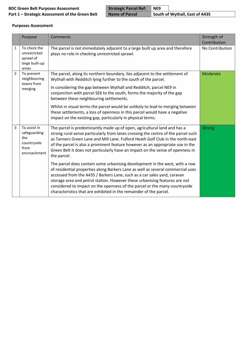
BDC Green Belt Purposes Assessment Strategic Parcel Ref: NE9
Part 1 – Strategic Assessment of the Green Belt Name of Parcel South of Wythall, East of A435
Purposes Assessment
Purpose Comments Strength of Contribution
1 To check the unrestricted sprawl of large built-up areas
The parcel is not immediately adjacent to a large built up area and therefore plays no role in checking unrestricted sprawl.
No Contribution
2 To prevent neighbouring towns from merging
The parcel, along its northern boundary, lies adjacent to the settlement of Wythall with Redditch lying further to the south of the parcel.
In considering the gap between Wythall and Redditch, parcel NE9 in conjunction with parcel SE6 to the south, forms the majority of the gap between these neighbouring settlements.
Whilst in visual terms the parcel would be unlikely to lead to merging between these settlements, a loss of openness in this parcel would have a negative impact on the existing gap, particularly in physical terms.
Moderate
3 To assist in safeguarding the countryside from encroachment
The parcel is predominantly made up of open, agricultural land and has a strong rural sense particularly from lanes crossing the centre of the parcel such as Tanners Green Lane and Mill Lane. Fulford Heath Golf Club in the north-east of the parcel is also a prominent feature however as an appropriate use in the Green Belt it does not particularly have an impact on the sense of openness in the parcel.
The parcel does contain some urbanising development in the west, with a row of residential properties along Barkers Lane as well as several commercial uses accessed from the A435 / Barkers Lane, such as a car sales yard, caravan storage area and petrol station. However these urbanising features are not considered to impact on the openness of the parcel or the many countryside characteristics that are exhibited in the remainder of the parcel.
Strong

BDC Green Belt Purposes Assessment Strategic Parcel Ref: NE10
Part 1 – Strategic Assessment of the Green Belt Name of Parcel Wythall Green, West of A435
Strategic Parcel Ref NE10
Name of Parcel Wythall Green, West of A435
Parcel size (ha) 381
BDC Parish/es Wythall
Other LPA Area N/A
Description of Parcel
Parcel NE10 is located in the east of the district and surrounds the large development of Wythall Green Business Park, which is inset from the Green Belt and therefore excluded from the parcel. The parcel is very open and predominantly made up of agricultural land, although Kings Norton Golf Club occupies a large portion of land in the west of the parcel.
In addition to a small number of isolated rural dwellings and farm buildings across the parcel, some development is located in the east of the parcel in the form of the Becketts Farm commercial development off the A435 and the Wythall Transport Museum, a caravan and motorhome park and St Mary’s Park residential/retirement village located off Chapel Lane. The River Cole runs through the centre of the parcel from north to south.
The parcel is bounded by Clewshaw Lane and Silver Street to the north, the A435 to the east, Watery Lane to the south and Brockhill Lane to the west. Land within the parcel generally falls in a north-west to south-east direction, albeit in a relatively gradual manner to a low point of 160m. The highest point in the parcel is by Kings Norton Golf Course (190m) on the western boundary.
Map of Parcel
© Crown copyright and database rights 2019
Ordnance Survey 100023519

BDC Green Belt Purposes Assessment Strategic Parcel Ref: NE10
Part 1 – Strategic Assessment of the Green Belt Name of Parcel Wythall Green, West of A435
Purposes Assessment
Purpose Comments Strength of Contribution
1 To check the unrestricted sprawl of large built-up areas
The parcel is not immediately adjacent to a large built up area and therefore plays no role in checking unrestricted sprawl.
No Contribution
2 To prevent neighbouring towns from merging
Parcel NE10 is located to the west of Wythall and lies between Wythall and Alvechurch in an east – west direction. The parcel also lies between Birmingham and Redditch in a north-south direction, albeit some distance from the edge of both of these settlements.
In considering the gap between Wythall and Alvechurch, parcel NE10 in conjunction with NE1 (in particular the southern section of the parcel) to the west, forms the majority of the gap between these neighbouring settlements.
Whilst in visual terms the parcel would be unlikely to lead to merging between these settlements, a loss of openness in this parcel would have a negative impact on the existing gap, particularly in physical terms.
Moderate
3 To assist in safeguarding the countryside from encroachment
The parcel is predominantly made up of open, agricultural land and has a strong rural sense particularly on land around Clewshaw Lane, Hill Lane and Watery Lane. Kings Norton Golf Club in the west of the parcel is a prominent feature however as an appropriate use in the Green Belt it does not particularly have an impact on the sense of openness in the parcel.
The parcel does contain some urbanising development in the east at Becketts Farm and off Chapel Lane, in the form of the Wythall Transport Museum and a retirement residential development. However these urbanising features are not considered to impact on the openness of the parcel or the many countryside characteristics that are exhibited.
Strong

BDC Green Belt Purposes Assessment Strategic Parcel Ref: NE11
Part 1 – Strategic Assessment of the Green Belt Name of Parcel South of Weatheroak Hill, North of M42
Strategic Parcel Ref NE11
Name of Parcel South of Weatheroak Hill, North of M42
Parcel size (ha) 237
Parish/es Alvechurch, Beoley
Other LPA Area N/A
Description of Parcel
The parcel is located between Birmingham and Redditch. The land parcel is located to the east of Bromsgrove District, to the north of the M42 motorway between Junctions 2 and 3.
The land parcel is bound to the north by Radford Road, Weatheroak Hill and Watery Lane, and to the east by the A345 Alcester Road. The parcel is bounded to the south entirely by the M42 Motorway and continues until meeting Radford Road.
The parcel is mainly green fields, with a limited number of residential dwellings, including the small settlement of Weatheroak Hill which is partially within this parcel. A small number of employment uses and Hillcrest Static Caravan Park are located off the A435.
There are three key roads which run through the land parcel including Dumble Pit Lane, Liley Green Road and Icknield Street, which cross the parcel north to south.
This parcel is dominated by a high mound of 177m in the west, before the land drops down in the middle of the parcel. It rises up again in the north towards the crossroads at Weatheroak Hill and a height of 180m.
Map of Parcel
© Crown copyright and database rights 2019 Ordnance Survey 100023519

BDC Green Belt Purposes Assessment Strategic Parcel Ref: NE11
Part 1 – Strategic Assessment of the Green Belt Name of Parcel South of Weatheroak Hill, North of M42
Purposes Assessment
Purpose Comments Strength of Contribution
1 To check the unrestricted sprawl of large built-up areas
The land parcel is not adjacent to a large built up area and therefore plays no role in checking unrestricted sprawl.
No Contribution
2 To prevent neighbouring towns from merging
The parcel is located between Birmingham and Redditch and also between Wythall and Redditch. The parcel, in conjunction with other land parcels constitutes the majority of a gap between Birmingham and Redditch, Alvechurch and Wythall and Wythall and Redditch. There is a static caravan park within the parcel and part of a Weatheroak Hill within the parcel; however this urbanising development would not mean this land is vulnerable due to the high level of openness in the majority of the parcel.
Moderate
3 To assist in safeguarding the countryside from encroachment
The land parcel has a rural sense and exhibits countryside characteristics but there are some urbanising features along the A345 Alcester Road of the static caravan park and garage which include street lighting and hard standing. There are some urbanising features in the vicinity of Weatheroak Hill which is within the parcel.
Moderate