analyzing the potential of geofencing for electric
TRANSCRIPT
Preliminary Investigation (PI-0246)
Caltrans Division of Research, Innovation and System Information
Analyzing the Potential of Geofencing for
Electric Bicycles and Scooters in the Public Right of Way
Requested by Seth Cutter, District 11 Planning Division
January 17, 2020
The Caltrans Division of Research, Innovation and System Information (DRISI) receives and evaluates numerous research problem statements for funding every year. DRISI conducts Preliminary Investigations on these problem statements to better scope and prioritize the proposed research in light of existing credible work on the topics nationally and internationally. Online and print sources for Preliminary Investigations include the National Cooperative Highway Research Program (NCHRP) and other Transportation Research Board (TRB) programs, the American Association of State Highway and Transportation Officials (AASHTO), the research and practices of other transportation agencies, and related academic and industry research. The views and conclusions in cited works, while generally peer reviewed or published by authoritative sources, may not be accepted without qualification by all experts in the field. The contents of this document reflect the views of the authors, who are responsible for the facts and accuracy of the data presented herein. The contents do not necessarily reflect the official views or policies of the California Department of Transportation, the State of California, or the Federal Highway Administration. This document does not constitute a standard, specification, or regulation. No part of this publication should be construed as an endorsement for a commercial product, manufacturer, contractor, or consultant. Any trade names or photos of commercial products appearing in this publication are for clarity only.
Table of Contents
Executive Summary ................................................................................................................. 2 Background ............................................................................................................................ 2 Summary of Findings .............................................................................................................. 2 Gaps in Findings ..................................................................................................................... 7 Next Steps .............................................................................................................................10
Detailed Findings ....................................................................................................................12 Background ............................................................................................................................12 Survey of Practice ..................................................................................................................13 Consultation With Experts ......................................................................................................19 Local Practices and Regulations ............................................................................................24 Related Research and Resources ..........................................................................................40
Contacts ..................................................................................................................................43 Appendix A: Survey Questions ..............................................................................................45

Produced by CTC & Associates LLC 2
Executive Summary
Background In cities and metropolitan areas across the country, electric bicycles (e-bikes) and electric scooters (e-scooters) are an inexpensive transportation alternative for transit users needing “last mile” travel options, as well as for tourists and those who have difficulty walking or biking long distances. However, e-bikes and e-scooters can create a safety hazard if they are operated in restricted areas such as access-controlled highways. In some cities, rental companies are required to use geofencing, which creates virtual geographic boundaries that restrict e-bikes and e-scooters from operating in specific areas and also limit their speed. The California Department of Transportation (Caltrans) is investigating whether geofencing could be used to:
• Prevent e-bikes and e-scooters from entering access-controlled highways and other specified locations.
• Limit the devices’ maximum speed in certain areas, allowing access to some bike paths and cycle tracks where they typically would not be allowed.
• Provide designated parking areas for scooters so they are less likely to be left in the public right of way.
To assist Caltrans in this investigation, CTC & Associates conducted an online survey of state departments of transportation (DOTs) and selected local jurisdictions in California and other states that examined these agencies’ experience with using geofencing for e-bikes and e-scooters. Consultations with selected vendors and a rider advocacy group gathered additional information about this geofencing application. A literature search supplemented the findings from the survey and consultations by identifying recent and relevant publications related to geofencing implementation for e-bikes and e-scooters.
Summary of Findings This Preliminary Investigation presents information in four areas:
• Survey of practice. • Consultation with experts. • Local practices and regulations. • Related research and resources.
Survey of Practice An online survey was distributed to members of the American Association of State Highway and Transportation Officials (AASHTO) Council on Active Transportation and selected local jurisdictions in California, Colorado and Texas to inquire about agency experience with geofencing to control the use of e-bikes and e-scooters. Eight state DOTs and eight local jurisdictions responded to the survey. Five local jurisdictions reported having experience with geofencing to control e-bike and e-scooter use. None of the eight state DOTs responding to the survey and the three remaining local jurisdictions require vendors of shared or rental e-bikes or e-scooters to use geofencing.

Produced by CTC & Associates LLC 3
Agencies With Geofencing Experience Five local jurisdictions reported having experience with geofencing to control e-bike and e-scooter use:
California • City of San Diego. • Los Angeles Department of Transportation.
Colorado • Denver Public Works. • City of Fort Collins.
Oregon • Portland Bureau of Transportation. (Note: While not included in the survey's
distribution list, this agency and another local agency in Oregon (City of Eugene) completed the survey.)
Survey results from these jurisdictions are summarized below in the following topic areas:
• Vehicle types and vendors.
• Geofencing applications.
• Facilities using geofencing.
• Geofencing performance.
• Other geofencing technologies.
• Challenges and lessons learned. Vehicle Types and Vendors
Geofencing requirements are applied to both e-bikes and e-scooters by three agencies (Los Angeles Department of Transportation, City of San Diego and Denver Public Works). Two agencies (City of Fort Collins and Portland Bureau of Transportation) apply geofencing requirements to e-scooters only. All five agencies have had geofencing requirements in place for less than six months. Four agencies (Los Angeles Department of Transportation, City of San Diego, Denver Public Works and Portland Bureau of Transportation) are working with multiple vendors to implement geofencing requirements. The City of Fort Collins is working with a single vendor (Bird Rides, Inc.). Table ES1 summarizes the vehicle types and vendors providing geofencing for the responding agencies.
Table ES1. Vehicle Types and Vendors Used By Respondents
State Agency Vehicle Type Vendor(s)
California Los Angeles Department of Transportation
E-bikes and e-scooters
Bird, Bolt, Jump, Lime, Lyft, Sherpa, Spin, Wheels
City of San Diego E-bikes and e-scooters
Bird, Juno, Lime, Lyft, Skip, Spin, Wheels

Produced by CTC & Associates LLC 4
State Agency Vehicle Type Vendor(s)
Colorado Denver Public Works1 E-bikes and e-scooters
Bird, Jump, Lime, Lyft, Razor, Spin
City of Fort Collins E-scooters only Bird
Oregon Portland Bureau of Transportation2 E-scooters only Bird, Bolt, Lime, Razor, Shared, Spin
1 A November 2019 online notice indicates that a competitive-bid contract will replace Denver’s current permitting system. Permittees will continue to operate through the pilot program until the city’s contracted vendor(s) begin operating, which is anticipated in summer 2020. See page 34 for more information.
2 All permitted e-scooter companies in Portland were subject to requirements beginning November 1, 2019. See page 37 for more information.
Geofencing Applications
All of the agencies use geofencing requirements to prevent access to specific roadways, trails or geographic areas. Geofencing requirements are used by four agencies to limit device speed in specific areas (Los Angeles Department of Transportation, City of San Diego, City of Fort Collins and Portland Bureau of Transportation), and by four agencies to designate approved or prohibited parking areas (Los Angeles Department of Transportation, Denver Public Works, City of Fort Collins and Portland Bureau of Transportation). Three agencies use geofencing requirements to delineate operational boundaries for a pilot program (Los Angeles Department of Transportation, City of San Diego and City of Fort Collins). Only the City of Fort Collins uses geofencing requirements to reduce riding on sidewalks. Facilities Using Geofencing
None of the agencies uses geofencing to restrict access or limit speed on bridges or access-controlled highways. Only Los Angeles Department of Transportation uses geofencing on local roadways. Three agencies use geofencing on trails or paths (Los Angeles Department of Transportation, City of Fort Collins and Portland Bureau of Transportation). Other facilities where geofencing is used to restrict access or limit speed include parks (Portland Bureau of Transportation), boardwalks and shared-use paths (City of San Diego), and pedestrian malls and plazas (Denver Public Works). Geofencing Performance
The Denver Public Works and City of San Diego respondents reported that geofenced boundaries generally work as expected and consistently across all vendors. However, respondents from Los Angeles Department of Transportation, City of Fort Collins and Portland Bureau of Transportation reported varying performance. In Los Angeles, the geofencing boundaries generally all work the same, depending on the e-bike’s or e-scooter’s ping rate (the e-bike or e-scooter location information that is automatically and consistently sent to the vendor’s servers). But the time it takes for the vehicle to recognize it is within a geofenced area will vary, causing some vehicles to take longer to decelerate. In Fort Collins, where a single vendor (Bird) is used, geofencing operation is inconsistent because of GPS limitations. In Portland, geofencing technology functions inconsistently, even within a single company. Within a single vendor’s fleet of vehicles, Los Angeles Department of Transportation and the City of San Diego reported no problems with consistent application of geofencing requirements. The remaining three respondents noted varying application of geofencing within a single vendor,
Produced by CTC & Associates LLC 5
such as inconsistent rider notification (Denver Public Works and Portland Bureau of Transportation) and GPS limitations (City of Fort Collins). These inconsistencies may be related to the ability to draw geofence boundaries given relatively low or variable geographic information system (GIS) accuracy. Other Geofencing Technologies
All of the responding agencies except the City of San Diego are investigating or have used geofencing that uses a GPS-enabled device embedded in the e-bike or e-scooter. Only two agencies—Los Angeles Department of Transportation and the City of San Diego—are investigating or have used geofencing that uses location data from the rider’s cellphone. None of the responding agencies has investigated or used Bluetooth beacons embedded in the sidewalk or right of way to delineate boundaries. Challenges and Lessons Learned
Several responding agencies noted challenges their agencies have identified with using geofencing, primarily related to the limitations of GPS and to cellphone issues. GPS inaccuracies allow some riders in Fort Collins to travel past a geofenced zone into prohibited areas while riders in Los Angeles report that vehicles register that they are within a geofenced area when they are actually traveling alongside or near a geofenced area. The latter circumstance may result in a change in vehicle speed. Yet the respondent from Denver Public Works noted that geofencing has been especially effective on the city’s 16th Street transit/pedestrian mall. Cellphones present challenges in San Diego when riders switch their phones to Airplane Mode to prevent being detected in geofenced areas. Agencies Reporting No Geofencing Experience None of the eight state DOTs responding to the survey requires vendors of shared or rental e-bikes or e-scooters to use geofencing. Three local jurisdictions responding to the survey—the cities of Austin, Texas, Beverly Hills, California, and Eugene, Oregon—also reported no current experience with geofencing. Two agencies—the City of Eugene and Rhode Island DOT—either have issued or have plans to issue requests for proposal (RFPs) for these devices. In Rhode Island, the City of Providence has issued an RFP and permits for shared e-bikes and e-scooters. In Oregon, the City of Eugene plans to issue an RFP in early 2020 for shared e-scooters and is considering using geofencing to lower speeds on city paths and to restrict parking in specified areas. An e-scooter community engagement process is underway in Eugene, and the proposed e-scooter pilot program is expected to launch in spring or summer 2020. In Texas and Wisconsin, e-bikes and e-scooters are subject to local regulation and oversight. North Carolina DOT does not contract directly with any providers, but communities in the state “have effectively used geofencing to limit access and speed.”
Consultations With Experts Representatives from two e-bike and e-scooter vendors, Bird Rides, Inc. and Spin, discussed their experience with geofencing and e-bikes and e-scooters. All five agencies responding to the survey work with Bird; four agencies work with Spin (Los Angeles Department of Transportation, City of San Diego, Denver Public Works and Portland Bureau of Transportation.) A representative from Santa Monica Spoke, a nonprofit organization dedicated to improving
Produced by CTC & Associates LLC 6
walking, biking and healthy active transportation in Santa Monica, California, also contributed to this discussion. Vendors Representatives from both vendors were interested in working with Caltrans on geofencing, though the Spin representative noted that any additional geofencing boundaries would likely also need to be coordinated with the cities that issue the scooter permits. Below are key topics discussed:
Technology. Both scooter vendors interact with geofencing boundaries via GPS devices in the scooters. Bird does not interact through a rider’s cellphone app; the Spin representative was uncertain whether the rider’s cellphone location is used and suggested that most larger vendors likely do not rely solely on cellphone locations as this would not meet cities’ permit requirements. Challenges and limitations of geofencing. The representatives from both vendors commented on the lack of precision with GPS technology. Bird noted that because GPS is a two-dimensional system, a geofencing boundary designed to prevent scooter riding on a highway overpass would also affect streets, bike lanes, trails or other facilities located beneath the highway. Both vendors also noted that GPS accuracy is affected by obstructions such as tall buildings; Bird has effectively applied geofencing boundaries to bridges and trails, as these facilities tend to be located in areas with fewer obstructions. In a Portland parks project, Spin trimmed the geofencing boundaries in a park to prevent “false positives” where scooters riding legally would be mistakenly slowed or stopped. Sidewalk riding. Bird and Spin are among the scooter providers that are partnering with the City of San Jose to develop innovative methods of preventing scooter riding on sidewalks. Providers are exploring the use of evolving technologies (such as Bluetooth beacons and cameras) along with nontechnical means (such as educational outreach) to address this issue. Sharing shapefiles. Encouraging cities to provide shapefiles of their desired boundaries to vendors could increase consistency across vendors and provide clear direction on precise boundary placement. Both vendors noted that there is value in having a city work with a vendor to ensure that the city’s desired boundaries reflect the limitations of GPS technology. Portland’s recent effort to share Spin shapefiles with other vendors was seen as a positive step.
Advocacy Groups The Santa Monica Spoke representative, who supports geofencing, recommended that Caltrans coordinate with local jurisdictions to avoid conflicts between local and state efforts and to ensure that all affected vendors are included in updates to geofencing boundaries within a municipality. Agencies should also be prepared to incorporate emerging technologies that will allow them to better integrate e-bikes and e-scooters into future regulations. When geofencing is used to regulate the speed of both e-bikes and e-scooters, it may be appropriate to set a lower speed for e-scooters because of operational differences between e-bikes and e-scooters. She also suggested that there may be paths or other areas where e-bikes would be appropriate, but e-scooters would not.

Produced by CTC & Associates LLC 7
Vendors initially were concerned about using geofencing to lower the speed of an e-scooter that entered a prohibited area. The representative from Santa Monica Spoke noted that in practice, the e-scooter decelerates gradually and this application has not created a safety issue. However, zero mph boundaries can create a challenge for riders if there is a delay in an e-scooter recognizing the geofence; riders who are not aware of the boundary may find themselves farther into the prohibited area than desirable. An audible warning on the e-scooters could alert riders that they are near a boundary.
Local Practices and Regulations Table ES2 summarizes information about the use of geofencing with e-bikes and e-scooters in local jurisdictions and universities in five states: California, Colorado, Florida, Oregon and Texas.
Table ES2. Local Practices and Regulations of Selected Agencies
State Agency Vehicle Type Vendor(s) Highlights of Agency Experience/Practices
California City of Beverly Hills N/A N/A
Temporary prohibition of shared mobility devices (specifically e-scooters) adopted July 24, 2018. One-year extension of the ban approved at December 2018 meeting. Council cited lack of cooperation from scooter companies. No indication on the city’s web site as to whether the ban will be continued or lifted.
City of San Diego E-bikes and e-scooters
Bird, Juno, Lime, Lyft, Skip, Spin, Wheels
One-year pilot. Geofenced facilities: Boardwalks and shared-use paths. Geofencing used to/for:
• Prevent access to specific areas. • Pilot program delineation. • Limit device speed. • Prevent vehicle from being locked, parked or
ending a ride at specific locations. • Designate parking zones; limit number and
location of vehicles parked together downtown.
• Reduce speed from 15 mph to 8 mph or 3 mph at specified locations.
City of San Jose E-bikes and e-scooters
Bird, Lime, Lyft, Spin
Permit program launched February 2019. Operators required to demonstrate compliance with the sidewalk prevention requirement in designated areas by January 31, 2020. Maximum speed limit of 12 mph.
City of Santa Monica
E-bikes and e-scooters
Bird, Jump, Lime, Lyft
Pilot program launched September 2018, initially for 16 months. City recently extended the pilot to May 2020 to develop a “Pilot 2.0” to explore enhanced regulations and street improvements. Geofenced facilities: Local roadways, trails or paths.

Produced by CTC & Associates LLC 8
State Agency Vehicle Type Vendor(s) Highlights of Agency Experience/Practices
California (continued)
City of Santa Monica (continued)
E-bikes and e-scooters
Bird, Jump, Lime, Lyft
Geofencing used to/for: • Remedy parking, safety and oversaturation
problems. • Reduce speed to zero mph around the beach
area (initial speed reduction then gradual stop).
Considering: • Expanding availability of drop zones. • Integrating in-app solutions to encourage
parking in geofenced drop zones.
Los Angeles Department of Transportation
E-bikes and e-scooters
Bird, Bolt, Jump, Lime, Lyft, Sherpa, Spin, Wheels
Geofenced facilities: Local roadways, trails or paths. Users can ride on surface streets and are encouraged to ride in bike lanes where available. Geofencing used to:
• Prevent access to specific areas. • Pilot program delineation. • Limit device speed. • Designate/prohibit parking areas.
Los Angeles City Council requires a cap on how many vehicles a company can operate inside city boundaries; liability coverage; community outreach and education; and data sharing. Currently developing a protocol and policy for using geofencing with e-bikes or e-scooters.
San Francisco Municipal Transportation Agency
E-scooters Jump, Lime, Scoot, Spin
Powered Scooter Share Permit Program launched July 2019. Four permits for a total of 4,000 scooters is the optimal allocation for the first round of the 12-month permanent program.
University of California, Los Angeles
E-bikes and e-scooters
Bird, Lyft, Wheels
Full pilot launched fall 2019. Pedestrian dismount zones limited to 1 mph; dismount zones delineated.
Colorado Denver Public Works
E-bikes and e-scooters
Bird, Jump, Lime, Lyft, Razor, Spin
Pilot permit program will continue to operate until the city’s contracted vendor(s) begin operating, which is anticipated in summer 2020. Geofenced facilities: Pedestrian mall, other specific locations. Geofencing used to:
• Prevent access to specific areas. • Designate/prohibit parking areas.
Produced by CTC & Associates LLC 9
State Agency Vehicle Type Vendor(s) Highlights of Agency Experience/Practices
Colorado (continued)
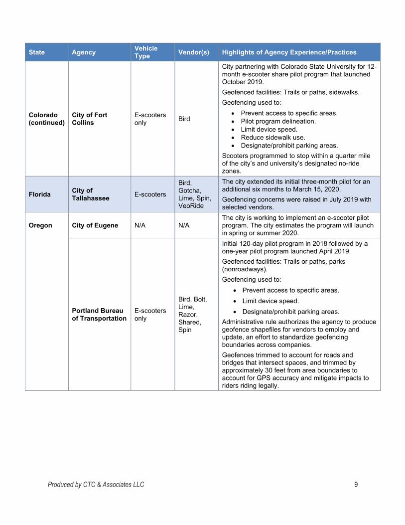
City of Fort Collins
E-scooters only Bird
City partnering with Colorado State University for 12-month e-scooter share pilot program that launched October 2019. Geofenced facilities: Trails or paths, sidewalks. Geofencing used to:
• Prevent access to specific areas. • Pilot program delineation. • Limit device speed. • Reduce sidewalk use. • Designate/prohibit parking areas.
Scooters programmed to stop within a quarter mile of the city’s and university’s designated no-ride zones.
Florida City of Tallahassee E-scooters
Bird, Gotcha, Lime, Spin, VeoRide
The city extended its initial three-month pilot for an additional six months to March 15, 2020. Geofencing concerns were raised in July 2019 with selected vendors.
Oregon City of Eugene N/A N/A The city is working to implement an e-scooter pilot program. The city estimates the program will launch in spring or summer 2020.
Portland Bureau of Transportation
E-scooters only
Bird, Bolt, Lime, Razor, Shared, Spin
Initial 120-day pilot program in 2018 followed by a one-year pilot program launched April 2019. Geofenced facilities: Trails or paths, parks (nonroadways). Geofencing used to:
• Prevent access to specific areas. • Limit device speed. • Designate/prohibit parking areas.
Administrative rule authorizes the agency to produce geofence shapefiles for vendors to employ and update, an effort to standardize geofencing boundaries across companies. Geofences trimmed to account for roads and bridges that intersect spaces, and trimmed by approximately 30 feet from area boundaries to account for GPS accuracy and mitigate impacts to riders riding legally.

Produced by CTC & Associates LLC 10
State Agency Vehicle Type Vendor(s) Highlights of Agency Experience/Practices
Texas City of Austin E-bikes and e-scooters N/A
The survey respondent indicated that geofencing was not employed by the city. However, news reports indicate that a pilot program that was expected to end in late September used geofencing to keep e-scooters off nonpaved trails (e-scooters are allowed on certain paved trails). A report on the pilot program is expected in early 2020.
The University of Texas at Austin E-scooters Bird, Jump,
Lime, Lyft
Geofencing initiated in March 2019 implemented a maximum acceleration of 8 mph in defined areas. Signage at major campus entry points alerts riders to a speed zone location. Standard speeds up to 15 mph in other zones.
Related Research and Resources Web sites of selected e-scooter vendors used by the local jurisdictions are highlighted. A sampling of publications address alternative technologies, including a 2019 article about the development of techniques to limit micromobility and a 2018 interview with a Bird policy expert who discusses using technologies such as Bluetooth beacons to create parking zones. Inconsistent throttling, a technology-related challenge associated with geofencing, is explained in two 2019 consumer publications.
Gaps in Findings The results of the survey and interviews with experts indicate that some e-scooters interact with geofencing boundaries via GPS receivers within the scooters while others rely on the rider’s cellphone app. Additional research is needed to determine which technology is more prevalent or effective. Also, e-scooters appear to be the subject of more recent research, ongoing pilot programs and other initiatives than e-bikes. Finally, a limited number of state DOTs and local agencies responded to the survey. Further attempts to engage with agencies not responding to the survey could produce useful guidance about geofencing for e-bikes and e-scooters.
Next Steps Moving forward, Caltrans could consider:
• Contacting the City of San Jose, California, about the results of its Sidewalk Riding Prohibition Technology program, including new or innovative approaches developed through the city’s partnership with vendors.
• Contacting vendors directly to learn more about geofencing technologies as they continue to evolve, including emerging approaches such as Bluetooth beacons embedded in infrastructure or cameras that use artificial intelligence to detect when a device is being operated on the sidewalk.

Produced by CTC & Associates LLC 11
• Following up with the City of Portland about the results of its recent effort to provide geofencing shapefiles developed by one vendor to all other vendors.
• Reaching out to additional agencies and local jurisdictions to learn about their experience and practices with using geofencing for e-bikes and e-scooters. (See page 17 for Other Contacts.)

Produced by CTC & Associates LLC 12
Detailed Findings
Background Electric bicycles (e-bikes) and electric scooters (e-scooters) have emerged as an alternative transportation mode in cities across the country, including several metropolitan areas in California. Bike-share and scooter-share services can provide an inexpensive option for “last mile” travel, connecting riders to transit services that might otherwise be unreachable. The devices are popular with tourists, and they offer another alternative to those who have difficulty walking or biking longer distances. However, the California Department of Transportation (Caltrans) has observed that e-bikes and e-scooters are sometimes operated in areas where they are not allowed and where they create a safety hazard to their riders or to bicyclists and pedestrians. Despite having a typical top speed of about 15 mph, e-scooters have been spotted on access-controlled freeways and expressways, and on San Diego’s Coronado Bay Bridge, which does not have a shoulder or pedestrian railing. Some cities require rental companies to use geofencing to control where and how fast e-bikes and e-scooters can be operated. Geofencing uses GPS or radio frequency identification (RFID) to create virtual geographic boundaries that trigger a response when a device enters or leaves a particular area. Caltrans is investigating the use of geofencing as a potential solution to recent challenges associated with e-bike and e-scooter sharing services. Caltrans is examining whether geofencing could be used to:
• Prevent the devices from entering access-controlled highways and other specified locations.
• Limit the devices’ maximum speed in certain areas, which could allow them to ride on certain bike paths and cycle tracks where they would not otherwise be allowed.
• Provide designated parking areas for scooters so they are less likely to be left in the public right of way.
To assist Caltrans in this information-gathering effort, CTC & Associates conducted an online survey of state departments of transportation (DOTs) and selected local jurisdictions in California and other states that examined these agencies’ experience with geofencing for e-bikes and e-scooters. Consultations with selected vendors and a rider advocacy group gathered additional information. Finally, a literature search identified recent and relevant publications related to implementing geofencing for e-bikes and e-scooters. Findings from these efforts are presented in this Preliminary Investigation in four topic areas:
• Survey of practice.
• Consultation with experts.
• Local practices and regulations.
• Related research and resources.
Produced by CTC & Associates LLC 13
Survey of Practice An online survey was distributed to members of the American Association of State Highway and Transportation Officials (AASHTO) Council on Active Transportation and appropriate contacts in the following local jurisdictions to inquire about agency experience with geofencing to control the use of e-bikes and e-scooters:
• Beverly Hills, California. • Los Angeles, California. • San Diego, California. • San Francisco, California. • San Jose, California. • Santa Monica, California. • University of California, Los Angeles. • Denver, Colorado. • Austin, Texas.
Survey questions are provided in Appendix A. The full text of survey responses is presented in a supplement to this report.
Summary of Survey Results Respondents from eight state DOTs and eight local jurisdictions responded to the survey:
State DOTs • Connecticut. • Georgia. • Idaho. • North Carolina.
• Rhode Island. • Texas. • Wisconsin. • Wyoming.
Local Jurisdictions California
• City of Beverly Hills. • City of San Diego. • Los Angeles Department of
Transportation. Colorado
• Denver Public Works. • City of Fort Collins.
Oregon • City of Eugene. • Portland Bureau of
Transportation. Texas
• City of Austin (incomplete response).
Of these, only five local jurisdictions reported on experience with geofencing to control the use of e-bikes and e-scooters.

Produced by CTC & Associates LLC 14
Survey findings are presented below in two categories: • Agencies with geofencing experience.
• Agencies reporting no geofencing experience.
Agencies With Geofencing Experience Respondents from five local jurisdictions reported on their agencies’ experience with geofencing:
• Los Angeles Department of Transportation. • City of San Diego. • Denver Public Works. • City of Fort Collins. • Portland Bureau of Transportation.
Geofencing Applications The cities of Fort Collins and Portland apply geofencing to restrict the operation of e-scooters only. The other three cities apply geofencing to both e-bikes and e-scooters. Three cities—Los Angeles, San Diego and Fort Collins—are using geofencing in connection with a pilot program. All five agencies have had geofencing requirements in place for less than six months. Table 1 identifies the type of vehicle subject to geofencing requirements and how each agency has used geofencing with e-bikes and/or e-scooters.
Table 1. Respondents’ Application of Geofencing Requirements
State Agency Vehicle Type
Prevent Access to Specific
Roadways, Trails or
Geographic Areas
Delineate Operational Boundaries for a Pilot Program
Limit Device
Speed in Geographic
Areas, Roadways or Trails
Reduce Riding on Sidewalks
Designate Approved
or Prohibited
Parking Areas
California Los Angeles Department of Transportation
E-bikes and e-scooters X X X X
City of San Diego
E-bikes and e-scooters X X X
Colorado Denver Public Works
E-bikes and e-scooters X X
City of Fort Collins
E-scooters only X X X X X
Oregon Portland Bureau of Transportation
E-scooters only X X X
Total 5 3 4 1 4

Produced by CTC & Associates LLC 15
Vendors Providing Geofencing All responding agencies except the City of Fort Collins are working with multiple vendors to implement geofencing requirements. All five agencies are working with at least one of the two vendors interviewed for this Preliminary Investigation (Bird Rides, Inc. and Spin). See Consultation With Experts, beginning on page 19, for a summary of our discussions with these vendors. Table 2 identifies the vendors providing geofencing for the responding agencies.
Table 2. Vendors Providing Geofencing
State Agency Geofencing Applied to E-Bikes/E-Scooters Vendor(s)
California Los Angeles Department of Transportation E-bikes and e-scooters Bird, Bolt, Jump, Lime, Lyft, Sherpa, Spin, Wheels
City of San Diego E-bikes and e-scooters Bird, Juno, Lime, Lyft, Skip, Spin, Wheels Colorado Denver Public Works1 E-bikes and e-scooters Bird, Jump, Lime, Lyft, Razor, Spin City of Fort Collins E-scooters only Bird
Oregon Portland Bureau of Transportation2 E-scooters only Bird, Bolt, Lime, Razor, Shared, Spin
1 A November 2019 online notice indicates that a competitive-bid contract will replace Denver’s current permitting system. Permittees will continue to operate through the pilot program until the city’s contracted vendor(s) begin operating, which is anticipated in summer 2020. See page 34 for more information.
2 All permitted e-scooter companies in Portland were subject to requirements beginning November 1, 2019. See page 37 for more information.
Facilities Using Geofencing None of the agencies use geofencing to restrict access or limit speed on bridges or access-controlled highways; only Los Angeles uses geofencing on local roadways. Table 3 describes the types of facilities on which respondents are using geofencing to restrict rider behavior.
Table 3. Facilities Using Geofencing to Restrict Access or Limit Speed
State Agency Local Roadways
Trails or Paths (Bike
Paths, Multiuse Trails)
Other Facilities
California Los Angeles Department of Transportation X X N/A
City of San Diego Boardwalks and shared-use paths
Colorado Denver Public Works Pedestrian mall, Union Station plaza, Major League Baseball stadium home games
City of Fort Collins X Sidewalks
Oregon Portland Bureau of Transportation
X Parks (not on a roadway)
Total 1 3

Produced by CTC & Associates LLC 16
Geofencing Performance Respondents reported on the performance of geofencing across vendors and within a single vendor’s fleet of vehicles. Across Vendors
The Denver Public Works and City of San Diego respondents reported that geofenced boundaries generally work as expected and consistently across all vendors. The other three responding agencies reported some degree of variability:
• Los Angeles Department of Transportation. While the geofencing boundaries generally all work the same, depending on the e-bike’s or e-scooter’s ping rate, the time it takes for the vehicle to recognize it is within a geofenced area will vary. Therefore, some vehicles may take longer to decelerate, depending on the vendor. (Note: Ping rate refers to a message the e-bike or e-scooter automatically and consistently sends to the vendor’s servers with the vehicle’s location information.)
• City of Fort Collins. The respondent noted that geofencing is not working consistently with its single vendor (Bird) and associates the problem with the limits of GPS.
• Portland Bureau of Transportation. The city’s geofencing requirements went into effect November 1, 2019, but some companies had voluntarily used geofencing to reduce speed, give audible warnings and/or prevent users from ending a trip in certain areas (for example, the city’s waterfront paths). Anecdotal and observational data suggest that even within a single company, the geofencing technology functions inconsistently.
Within a Single Vendor
Respondents from Los Angeles Department of Transportation and City of San Diego reported no problems with consistent application of geofencing requirements within a single vendor. The other three respondents highlighted varying degrees of inconsistent application of geofencing:
• Denver Public Works. Some vehicles provide rider notifications; others do not.
• City of Fort Collins. The respondent noted again that geofencing is not working consistently with its single vendor (Bird) and associates the problem with the limits of GPS.
• Portland Bureau of Transportation. Anecdotal evidence suggests that within a company, some e-scooters give audible warnings to users and slow down when entering geofenced areas while others do not. The cause of this is unknown, but one technological challenge the respondent noted is the ability to draw geofence boundaries given relatively low or variable geographic information system (GIS) accuracy at such a granular scale.
Other Geofencing Technologies Respondents were asked about geofencing approaches or technologies their agencies have investigated, used or discussed with vendors. All of the responding agencies except the City of San Diego are investigating or have used geofencing that uses a GPS-enabled device embedded in the e-bike or e-scooter. Only two agencies—Los Angeles Department of Transportation and the City of San Diego—are investigating or have used geofencing that uses

Produced by CTC & Associates LLC 17
location data from the rider’s cellphone. None of the responding agencies has investigated or used Bluetooth beacons embedded in the sidewalk or right of way to delineate boundaries. Challenges and Lessons Learned Respondents highlighted challenges their agencies have identified during the relatively short time geofencing has been in place:
GPS-Related Limitations
• Los Angeles Department of Transportation. The agency has received user complaints related to vehicle GPS errors or inaccurate reporting. Some vehicles register that they are within a geofenced area when actually the vehicles are traveling alongside or near a geofenced area. In these circumstances, the speed of the vehicle may change, and riders will not understand why. Reliability can vary by provider depending on the GPS of the vehicles. In Venice, California, the agency implemented a geofenced area where speeds would be throttled to zero mph for vehicles on the Venice Boardwalk area. Some providers’ vehicles took longer than others to recognize that they were within the zone and to reduce speeds. To address issues with vehicles that may take longer to stop, some providers implemented a buffer zone and pushed the boundaries of their geofence slightly.
• Denver Public Works. While geofencing is imperfect, especially in downtown areas and near tall buildings, it has been especially effective on the city’s 16th Street transit/pedestrian mall.
• City of Fort Collins. Limitations of GPS allow riders to sometimes ride past a geofenced zone into prohibited areas.
Cellphone-Related Issues
• City of San Diego. Providers faced challenges with riders using Airplane Mode on their phones to prevent being detected in the geofenced areas.
Other Contacts Survey respondents recommended the following cities, organizations or individuals as potential resources for additional information about geofencing. The limited scope of this Preliminary Investigation did not allow for expanded outreach efforts to include these contacts.
• California. Kyle Kozar, Mobility Division, City of Santa Monica, 310-458-8341, [email protected]. (Note: We contacted Kozar in connection with the survey but did not receive a response.)
• Colorado. Cindy Patton, Interim Director, Public Works, Transportation Operations, City and County of Denver, 720-865-3157, [email protected].
• Idaho. City of Boise.
• North Carolina: o City of Charlotte. o City of Durham. o City of Greensboro.

Produced by CTC & Associates LLC 18
o City of Raleigh. o North Carolina State University.
• Rhode Island: o Martina Haggerty, Department of Planning and Development, City of Providence,
[email protected]. o Alex Ellis, Department of Planning and Development, City of Providence,
Agencies Reporting No Geofencing Experience None of the eight state DOTs responding to the survey require vendors of shared or rental e-bikes or e-scooters to use geofencing. Three of the local jurisdictions responding to the survey—the cities of Austin, Beverly Hills and Eugene—also reported no current experience with geofencing. Some of these respondents offered additional comments:
• In Oregon, the City of Eugene does not have experience with shared e-bikes or e-scooters but does offer semidockless bike share. The city plans to issue a request for proposal in early 2020 for shared e-scooters and is considering using geofencing to lower speeds on city paths and restrict parking, especially near the Willamette River, to prevent scooters from being dumped in the river. Also, a community engagement process with regard to e-scooters is underway. Information about the proposed e-scooter pilot program in Eugene, predicted to launch in spring or summer 2020, is available on page 35 of this Preliminary Investigation.
• While Rhode Island DOT has not procured any venders for shared e-bikes and/or e-scooters, the respondent noted that the City of Providence has issued a request for proposal and permits for shared e-bikes and e-scooters. (See Other Contacts above.)
• While North Carolina DOT does not contract directly with any providers, communities in the state “have effectively used geofencing to limit access and speed.”
• In Texas and Wisconsin, e-bikes and e-scooters are subject to local regulation and oversight.
• Connecticut DOT does not currently operate any kind of geofencing on state property, and no e-bike or e-scooter vendors are currently operating in Wyoming.

Produced by CTC & Associates LLC 19
Consultation With Experts We contacted the following vendor and advocacy group representatives known to have experience with e-bikes and e-scooters:
Vendors • Bird Rides, Inc. • Spin.
Rider Advocacy Group • Santa Monica Spoke.
Below are summaries of email exchanges or phone conversations with each organization.
Vendors
Bird Rides, Inc. Contacts: Lys Mendez, Government Partnerships, Bird Rides, Inc., [email protected]; Tom
Santinelli, Product Operations, Bird Rides, Inc., [email protected]. Bird e-scooters are deployed in several California cities, including Long Beach, Los Angeles, Oakland, San Diego, San Jose and Santa Monica. We spoke with two Bird representatives: Lys Mendez, Government Partnerships, and Tom Santinelli, Product Operations. Mendez and Santinelli indicated that Bird is very interested in working directly with Caltrans to discuss Caltrans’ goals and identify the best ways to achieve them. Below are the key topics we discussed.
• Partnering with cities and other agencies: From a policy perspective, Bird takes a big-picture approach, with a focus on enhancing mobility and providing alternatives to automobile travel. While geofencing is a valuable tool, Mendez noted that it can lead to undesired impacts, such as decreased ridership (limiting mobility) or riders abandoning scooters at the edge of the geofenced boundary.
o In the case of scooter riding on highways and bridges, Mendez said Bird is interested in working with agencies to understand how often this occurs, identify why riders may be choosing these routes and discuss appropriate solutions.
• Technology: Bird scooters interact with geofencing boundaries via GPS devices in the scooters themselves (using proprietary hardware and firmware), not through a rider’s cellphone app. Bird receives location data on its scooters every few seconds.
• Challenges and limitations of geofencing: o Santinelli noted that the U.S. government owns the GPS navigation system, and
locations are assumed to be accurate to within 15 to 40 meters. This means that GPS technology is not currently able to establish very precise boundaries, such as outlining a sidewalk that may be 2 to 3 meters wide.
o Because GPS is set up as a two-dimensional system, a geofencing boundary designed to prevent scooter riding on a highway overpass would also affect

Produced by CTC & Associates LLC 20
streets, bike lanes, trails or other facilities located beneath the highway, Santinelli said.
o GPS accuracy is affected by obstructions such as tall buildings. Santinelli noted that Bird is able to effectively apply geofencing boundaries to facilities such as bridges and trails, as these facilities tend to be located in areas with fewer obstructions.
• Alternatives: In light of the challenges inherent to GPS technology, Santinelli suggested that alternative solutions may be appropriate in some areas. In the case of people riding scooters on highways, for example, signs may help educate riders that scooters are prohibited on these facilities. Santinelli also suggested that expanding the responsibilities of law enforcement to include ticketing scooter riders may be an effective deterrent.
• Sidewalk riding: Bird is among the scooter providers that are partnering with the City of San Jose to develop innovative methods of preventing scooter riding on sidewalks. Mendez said that Bird appreciates the opportunity to innovate alongside the city and other providers in exploring how to use evolving technologies along with nontechnical means such as educational outreach to meet the city’s needs.
• Sharing shapefiles: Mendez supported the City of Portland’s recent effort to share geofencing shapefiles developed by one provider with other providers. She noted that it is helpful when an agency is able to provide map files that outline desired boundaries rather than having providers interpret where boundaries should be placed.
For additional information on the capabilities and limitations of geofencing, Santinelli recommended the following article:
“Using Location Data for Guiding Micromobility Outcomes,” Morgan Herlocker, Blog Post, SharedStreets, March 2019. https://sharedstreets.io/using-location-data-for-guiding-micromobility-outcomes/ From the article: Scooter and bike share services present cities an opportunity to move more people in less space while providing more equitable transportation options. Most cities expect private mobility companies to further policy goals around safety, equity and sustainability in return for their use of public infrastructure. Location data—information about where things are in the world, such as phones or scooters—is ubiquitous today, and can help monitor how micromobility services interact with street infrastructure. This post will explore the capabilities of this data, as well as the hardware limitations.
Related Resource:
Bird Rides, Inc., Bird Rides, Inc., 2019. https://www.bird.co/ Based in Santa Monica, Bird Rides provides e-scooter rental services in both domestic and international communities, including 56 cities and 24 college campuses in North America. A map at the vendor web site (https://www.bird.co/map/) shows the current availability of Bird scooters.

Produced by CTC & Associates LLC 21
Spin Contact: Kyle Rowe, Head of Government Partnerships, Spin, 206-965-5258, [email protected]. Spin scooters are available in 62 cities, including seven in California: Isla Vista, Long Beach, Los Angeles, Oakland, San Diego, San Francisco and San Jose. We spoke with Kyle Rowe, head of government partnerships at Spin. Rowe said Spin would be interested in talking with Caltrans about geofencing, though he noted that any additional geofencing boundaries would likely need to be coordinated with the cities that issue the scooter permits as well. Rowe felt it would typically be clear which cities to coordinate with, as Spin’s service areas do not generally overlap. Below are the key topics we discussed.
• Technology: Spin scooters interact with geofencing boundaries via GPS devices in the scooters; Rowe was uncertain about whether the rider’s cellphone location is used as well. He suggested that most larger vendors likely do not rely solely on cellphone locations, as this would not meet cities’ permit requirements.
• Challenges and limitations of geofencing: Rowe echoed Bird representatives’ comments regarding the precision of the GPS system; he said coordinates are presumed to be accurate to within 50 feet. He noted that the system is less accurate in areas where buildings obstruct the GPS signal.
o As noted by the representatives from Bird, GPS is a two-dimensional system. Rowe gave an example of an altitude-related conflict in Portland, where he worked with the Portland Bureau of Transportation and Portland Parks and Recreation to create geofencing boundaries around the city’s parks. In and around the city’s Waterfront Park, multiuse bridges (where scooter riding is permitted) pass over park areas where scooters are prohibited or speeds are limited. In this case, geofencing boundaries were trimmed to prevent “false positives” where scooters riding legally would be mistakenly slowed or stopped.
o Rowe noted that geofencing does not affect privately owned scooters.
• Sidewalk riding: Like Bird, Spin is among the scooter companies involved in San Jose’s Sidewalk Riding Prohibition Technology Program. Rowe said Spin has investigated several alternative technologies, including the use of Bluetooth beacons and cameras to detect when a scooter is on the sidewalk, but that none has proved workable yet.
• Sharing shapefiles: Rowe described Spin’s experience with developing geofencing boundaries around parks in Portland and then allowing those shapefiles to be shared with other vendors. Although Spin invested time working with two agencies to develop the boundaries, Rowe noted: “It’s mostly about the safety of people in Portland, so it’s OK to share with everyone.” He concurred with Bird’s representatives that having cities provide shapefiles of their desired boundaries to vendors is a good approach.
Related Resource:
Spin, Skinny Labs Inc., 2019. http://spin.app Spin currently provides shared e-scooters in 62 cities and 16 campuses throughout the United States (scroll down the homepage to view a map of current locations).
Produced by CTC & Associates LLC 22
Rider Advocacy Group
Santa Monica Spoke Contact: Cynthia Rose, Director, Santa Monica Spoke, [email protected]. Santa Monica Spoke is a nonprofit organization dedicated to improving walking, biking and healthy active transportation in Santa Monica. The organization is a local affiliate of the Los Angeles County Bicycle Coalition and the California Bicycle Coalition. We spoke with Cynthia Rose, director of Santa Monica Spoke and a member of the board of directors of the California Bicycle Coalition. Rose served on an advisory committee that helped write Santa Monica’s scooter rules. Below are the key topics we discussed.
• Coordination between Caltrans and local jurisdictions: Rose is supportive of geofencing. She noted that geofencing boundaries outlining prohibited areas or speed restrictions are currently set by the municipalities that issue permits to vendors. If Caltrans decides to pursue geofencing, Rose recommended that Caltrans coordinate with local jurisdictions in the area to avoid conflicts between local and state efforts. In some areas, especially near the border between two municipalities, it may be necessary to contact more than one municipality to ensure that all affected vendors are included in any updates to geofencing boundaries.
• Emerging technologies: Rose also recommended that Caltrans look to “regulate with an eye on the future,” and said agencies should be ready to incorporate emerging technologies that will allow them to better integrate e-bikes and e-scooters into any regulations being developed.
• Differences between e-bikes and e-scooters: Rose noted that e-scooters are fundamentally different from e-bikes in terms of maneuverability (scooters are able to nimbly weave around pedestrians in a way that can create conflicts). She suggested that in an area where geofencing is used to regulate the speed of both e-bikes and e-scooters, it may be appropriate to set a lower speed for e-scooters than for e-bikes. She also suggested that there may be paths or other areas where e-bikes would be appropriate, but e-scooters would not.
o Regarding e-bikes, Rose noted that there are two kinds of e-bikes: pedal-assist e-bikes, which require the rider to pedal in order to engage the motor, and throttle e-bikes, which do not. Rose said shared mobility bikes are typically pedal-assist, which means that a rider could pedal faster than the top speed set by a geofence.
• Rider experience with crossing into a prohibited area: Rose said that some e-scooter vendors initially raised concerns that using geofencing to slow a scooter to zero mph (as in an area where scooters are prohibited) would present a safety hazard, leading to riders falling off the devices. She said that in practice, however, the e-scooter decelerates gradually, and using zero mph boundaries has not created a safety issue.
o Rose noted that zero mph boundaries can create a challenge for riders when there is a delay in an e-scooter recognizing the geofence (potentially due to a ping rate that is slower than expected). Riders who are not aware of the

Produced by CTC & Associates LLC 23
boundary may find themselves farther into the prohibited area than is desirable when the e-scooter stops.
o Rose suggested that this could be helped by having an audible warning on the e-scooters, similar to the beep that scooters emit when they fall over, that would alert riders that the boundary is approaching.
Related Resource:
Santa Monica Spoke, Santa Monica Spoke, undated. https://smspoke.org/about/ From the web site:
Santa Monica Spoke [i]s a 501(c)3 organization dedicated to improving walking, biking and healthy active transportation in the City of Santa Monica. We are a community based nonprofit working to make Santa Monica more sustainable, and a better place to live, walk, bike, work and play. [The organization advocates] the implementation of Complete Streets Policies that support and protect all users, (pedestrians and people on bikes) and the use of public transit and shared mobility options to promote fewer single car trips for a healthier, safer, more sustainable environment for the community at large.

Produced by CTC & Associates LLC 24
Local Practices and Regulations The citations below provide information about the use of geofencing with e-bikes and e-scooters in local jurisdictions and by universities in five states: California, Colorado, Florida, Oregon and Texas. Contact information, either from survey responses or identified using the resources cited, is included for many of the agencies and organizations addressed below. Note: This is an emerging topic that has yet to be thoroughly studied through formal research
projects. To provide a fuller picture of agencies’ experience in this area, the citations that follow include supplementary information from media outlets.
California
State and Local Practices and Regulations Project in Progress: Curbside Management: Understanding Impacts of On-Demand Mobility on Public Transit Use and Vulnerable Road Users, California Department of Transportation, start date: April 2019; expected completion date: June 2020. Project description at https://transweb.sjsu.edu/mctm/research/utc/Curbside-Management-Understanding-Impacts-Demand-Mobility-Public-Transit-Use-and-Vulnerable-Road-Users From the description: The goal of this project is to develop recommended best practices of curb management for an array of innovative transportation modes (e.g., carsharing, bikesharing, scooter sharing, ridesourcing/transportation network companies (TNCs), etc.). Such practices may include mechanisms such as: (1) fees for access and use; (2) prioritizing access for public transportation, cyclists, pedestrians, elderly, youth, and disabled populations; (3) geofencing to limit curb access; and (4) pricing to reflect key priorities (e.g., high-occupancy vehicles, walking and cycling, clean vehicles, etc.). AB-1112 Shared Mobility Devices: Local Regulation, California Assembly Bill 1112 (2019-2020), June 2019. https://leginfo.legislature.ca.gov/faces/billTextClient.xhtml?bill_id=201920200AB1112 This California Assembly bill, most recently amended and re-referred to the Committee on Transportation on June 19, 2019, reads in part:
The bill would allow a local authority to enact reasonable regulations on shared mobility devices and providers within its jurisdiction, including, but not limited to, requiring a shared mobility service provider to obtain a permit. The bill would allow a local authority to ban persons from deploying and offering shared mobility devices for hire on its public right of way, subject to the California Environmental Quality Act.

Produced by CTC & Associates LLC 25
Related Resource: “State Bill Taking Aim at City Bikeshare, Scooter Regulations Stalls in Senate,” Joe Fitzgerald Rodriguez, San Francisco Examiner, July 2019. https://www.sfexaminer.com/the-city/state-bill-taking-aim-at-city-bikeshare-scooter-regulations-stalls-in-senate/ From the article:
Assembly Bill 1112 [AB 1112], authored by Assembly member Laura Friedman (D-Glendale), has sputtered to a stop in the state Senate along with some other shared mobility-related bills after it met with growing opposition from California cities. …. Some parties besides shared mobility operators had problems with California cities’ opposition. The Electronic Frontier Foundation [EFF], a nonprofit aiming to protect civil liberties, hoped the bill would prevent cities from disclosing personal trip data of e-scooter and e-bike renters. Even without names attached, EFF argued, it is easy to identify who took individual trips and track a person’s movements. But in June, the state Senate Committee on Transportation voiced its own concerns with AB 1112. In particular, the committee questioned AB 1112’s restrictions on cities’ ability to require shared mobility companies operate in what are called “communities of concern.” Essentially, this is a requirement cities use to ensure poor people and minorities have access to services. As written, AB 1112 would have removed this option. The committee also expressed concern AB 1112 would undermine local authorities’ ability to regulate speed limits for shared mobility services. “It is unclear why these two specific aspects of shared mobility device regulation should be singled out for state regulation while all other specifics are left up to local authorities,” the senate transportation committee wrote in its evaluation of the bill.
“Scooter Wars: Local Approaches to Regulating Shared Mobility Devices,” Zachary M. Heinselman, Emily B. Milder and Laurence S. Weiner, League of California Cities 2019 Spring Conference, May 2019. https://www.cacities.org/Resources-Documents/Member-Engagement/Professional-Departments/City-Attorneys/Library/2019/Spring-2019/5-2019-Spring;-Heinselman-Scooter-Wars-Challenges.aspx From the conference paper: In late 2017, seemingly overnight, electric scooters appeared on the streets and sidewalks of the City of Santa Monica, and soon became ubiquitous throughout several Los Angeles neighborhoods and the Bay Area. The scooters—dockless, accessed via a smartphone app, able to reach speeds of fifteen miles per hour, usually operated on the sidewalk by riders without helmets, and often haphazardly parked or tossed in the public right-of-way—are despised by some and loved by others. Cities, concerned that the scooters pose safety hazards to pedestrians, riders and drivers, and frustrated by the unsightly scattering of vehicles not in use, have taken various approaches toward regulating these new “shared mobility devices.” This paper will explore several of those specific approaches and address the most significant challenges faced by cities in designing and implementing shared mobility device (“SMD”) regulation, namely, potential conflicts with the California Vehicle Code, enforcement capability, compliance with the California Environmental Quality Act (“CEQA”), liability for personal injuries, and compliance with the Americans with Disabilities Act (“ADA”).

Produced by CTC & Associates LLC 26
Motorized Scooter, State of California Department of Motor Vehicles, 2019. https://www.dmv.ca.gov/portal/dmv/detail/vr/scooters From the web site:
A motorized scooter may be operated on a bicycle path, trail or bikeway, but not on a sidewalk. An individual shall not operate a motorized scooter: ….
• On a highway with a posted speed limit greater than 25 miles per hour (mph) unless it is within a Class II or IV bikeway. However, a local authority may adopt an ordinance or resolution authorizing operation of a motorized scooter on a highway with a posted speed limit of up to 35 mph.
A Class II bikeway provides a striped lane for one-way bike travel on a street or highway. A Class IV bikeway, often referred to as a cycle track or protected bike lane, is for the exclusive use of bicycles, physically separated from motor traffic with a vertical feature. The separation may include, but is not limited to, grade separation, flexible posts, inflexible barriers, or on-street parking. Separated bikeways can provide for one-way or two-way travel. A motorized scooter may not be operated at a speed in excess of 15 mph on all highways, including bikeways, regardless of a higher speed limit applicable to the highway.
Beverly Hills Contact: Christian Vasquez, Transportation Planning, City of Beverly Hills, 310-285-1161,
[email protected]. Scooters, City of Beverly Hills, 2019. http://www.beverlyhills.org/departments/policedepartment/policedivisions/traffic/scooters/ This web site includes the following scooter advisory:
The Beverly Hills Police Department will continue to enforce regulations on the use of motorized scooters throughout the City of Beverly Hills. This will include impounding shared mobility devices and issuing citations related to vehicle code violations resulting in fines. The City Council adopted an urgency ordinance on July 24, 2018, to temporarily prohibit shared mobility devices, specifically motorized scooters, within Beverly Hills [c]ity limits. The ordinance prohibits the shared devices from being placed in any public right-of-way or on public property, operated in any public right-of-way or on public [property].
Related Resource:
“Beverly Hills Extends Electric Scooter Ban By One Year,” Luke Harold, Park Labrea News/Beverly Press, December 13, 2018. https://beverlypress.com/2018/12/beverly-hills-extends-electric-scooter-ban-by-one-year/ From the article: The six month ban on shared mobility devices in Beverly Hills, mainly aimed at Bird and Lime saturating local streets with scooters, expired this month without a new ordinance council members were hoping for to regulate the devices. Riders zipping past pedestrians on sidewalks at speeds up to 15 mph and scooters left in public rights of way contributed to the Beverly Hills City Council’s decision to ban the

Produced by CTC & Associates LLC 27
devices, unless the city and the shared mobility companies can agree on a regulatory framework. Citing a lack of cooperation from the scooter companies over the past six months, the City Council approved a one-year extension to its shared mobility device ban at its Dec. 11 meeting. The ban could be shortened if council members establish a pilot program.
Los Angeles Contacts: Jose Elias, Bureau of Transportation Technology, Los Angeles Department of
Transportation, 213-972-4944, [email protected]; Alison Hewitt, University of California, Los Angeles, [email protected].
Dockless Mobility Program: More Choices + Better Mobility, Los Angeles Department of Transportation, undated. https://ladot.io/programs/dockless/ From the web site: People in Los Angeles deserve safe and comfortable transportation choices to get around this great city. That’s why LADOT [Los Angeles Department of Transportation] created a pilot [o]ne-[y]ear permit to regulate and manage dockless scooters and bicycles. LADOT will work to ensure safety, comfort and equity for all who wish to use dockless scooters and bikes. …. Who is enforcing State and City rules? LADOT will ensure that [d]ockless [m]obility [p]roviders follow regulations outlined in the [o]ne-[y]ear permit. LAPD [Los Angeles Police Department] will ticket anyone they find riding an e-scooter on the sidewalk. Any vehicle parked in any one location for more than 5 consecutive days without moving is subject to removal by LA Sanitation. LAPD traffic divisions are responsible for ticketing sidewalk riding. For concerns about sid[e]walk riding, community members may contact LAPD division captains. Related Resource:
“LA Leaders Say Scooter Companies Must ‘Step Up and Do Better,’” Elijah Chiland, Curbed Los Angeles, June 14, 2019. https://la.curbed.com/2019/6/14/18679094/los-angeles-scooters-rules-pilot From the article:
Three months into a new permitting program regulating dockless bikes and scooters on the streets of Los Angeles, city leaders expressed frustration Wednesday with the results of the one-year pilot so far. …. Under the terms of LA’s yearlong pilot, which began in March, eight companies have been authorized to deploy a combined 36,170 devices (a mix of scooters and electric bikes) throughout the city. A report from the city’s transportation department shows the vehicles have gotten a fair amount of use. Between December 31 and April 15 (when companies only had conditional permits and could deploy fewer vehicles), users took nearly 1.9 million rides on the devices.
Produced by CTC & Associates LLC 28
Electric Scooter Policy, UCLA Transportation, University of California, Los Angeles, 2019. https://www.transportation.ucla.edu/getting-around-campus/electric-scooter-policy From the web site: UCLA [University of California, Los Angeles] prioritizes the safety of the campus community. UCLA Transportation would like to highlight the importance of campus road safety and provide an overview of state laws regarding electric scooters. Related Resources:
“UCLA Transportation Agreement With E-Scooter Companies to Impose New Restrictions,” Stephen Wyer, Daily Bruin, September 15, 2019. https://dailybruin.com/2019/09/15/ucla-transportation-agreement-with-e-scooter-companies-to-impose-new-restrictions/ From the article: UCLA said its goal is to minimize the impact on pedestrians, improve safety and benefit students. To this end, UCLA has made infrastructure improvements on campus such as introducing new protected bike lanes, as well as repairing and repaving campus streets to create better riding conditions. In conjunction with such efforts, the e-scooter vendors are implementing more sophisticated geofence software on their apps, which will prevent students from parking in restricted areas and keep e-scooters off sidewalks and pedestrian areas. A geofence is a virtual parameter in a physical area that, when crossed, will send a message to the user. “UCLA Reaches Agreement With Three E-Scooter and E-Bike Companies,” Karen Hallisey and Alison Hewitt, Press Release, University of California, Los Angeles, August 2019. http://newsroom.ucla.edu/stories/ucla-reaches-agreement-with-three-e-scooter-and-e-bike-companies From the press release:
As part of a shared mobility strategy, UCLA has signed a provisional contract with Lyft, Bird and Wheels to provide electric scooters and bikes to the campus community. According to the agreement, shared e-scooters and e-bikes from unapproved vendors can continue to ride through campus roads, but they will be impounded if parked on campus. For pedestrian safety, e-bikes and e-scooters are prohibited on campus sidewalks and pathways. …. The arrangement soft-launched Aug. 1; a full pilot program will roll out this fall. …. Geofencing will limit motors to 1 mile per hour in UCLA’s pedestrian dismount zones, such as Bruin Walk, and help riders find approved parking zones. … Dismount zones have also been delineated in campus areas with high foot traffic to minimize impacts on pedestrian walkways.

Produced by CTC & Associates LLC 29
San Diego Contact: Ahmad Erikat, Traffic Operations, City of San Diego, 619-533-3045,
[email protected]. Motorized Bicycle and Scooter Sharing, Bicycling, City of San Diego, 2019. https://www.sandiego.gov/bicycling/bicycle-and-scooter-sharing From the web site:
There are several bicycle and scooter sharing companies currently operating in the City of San Diego. The [c]ity has shared applicable rules and regulations and safety guidelines with the bike and scooter sharing companies and is monitoring the operations to ensure the companies and their customers are aware of these rules.
Speed and parking are restricted for dockless bikes and scooters in areas of the city. A map of restricted areas is available at https://sandiego.maps.arcgis.com/apps/webappviewer/index.html?id=c342a8e0c9354323b8210dab0e930bc9. Related Resources:
§83.0308 Geofencing Speed and Operating Restrictions, Chapter 8: Traffic and Vehicles, San Diego Municipal Code, June 2019. https://docs.sandiego.gov/municode/MuniCodeChapter08/Ch08Art03Division03.pdf From page 6 of the PDF:
(a) Through geofencing or similar technology, an operator shall reduce the speed of any motorized scooters and motorized bicycles in the operator’s fleet to eight miles per hour or less at [specified locations.] …. (b) Through geofencing or similar technology, an operator shall prevent any motorized scooters and motorized bicycles in the operator’s fleet from being locked, parked or ending a ride, and shall reduce the speed of its motorized scooters and motorized bicycles to eight miles per hour at [specified locations.] …. (c) Through geofencing or similar technology, an operator shall prevent any motorized scooters and motorized bicycles in the operator’s fleet from being locked, parked or ending a ride, and shall reduce the speed of any motorized scooters and motorized bicycles in its fleet to three miles per hour at [specified locations.]
“New Regulations for Dockless Scooters, Bikes Take Effect,” FOX 5 Digital Team and Andrew Nomura, KSWB (FOX 5), July 1, 2019. https://fox5sandiego.com/2019/07/01/new-regulations-for-dockless-scooter-bikes-take-affect/ From the article: The package of regulations, which was passed by the City Council in April, limits the speed of dockless scooters from 15 mph to 8 mph in high-traffic areas like Spanish landing and near Petco [P]ark, and as low as 3 mph along the Embarcadero, the Martin Luther King Jr. Promenade and the boardwalk in Mission and Pacific Beach.

Produced by CTC & Associates LLC 30
Scooter companies like Bird, Lime and Razor will now [be] required to use geofencing technology on their scooters to limit speeds and parking abilities in designated areas around the city. Bird already uses geofencing to reduce scooter speeds in areas like the Santa Monica Beach Bike Path. Scooter riders are banned from parking the devices near hospitals, schools, beach area boardwalks, the Petco Park perimeter and the north and south legs of the Embarcadero. The city is designating scooter parking zones along city streets to decrease the number of scooters parked on sidewalks. In downtown, scooter riders and companies are only able to park devices in groups of four, with at least 40 feet between groups. “Deadline Reached for San Diego Mayor Kevin Faulconer’s Scooter Company Ultimatum,” Mackenzie Maynard, KGTV (ABC 10 News San Diego), July 30, 2019. https://www.10news.com/news/local-news/mayor-faulconers-deadline-for-scooter-company-ultimatum From the article: The city is cracking down on its scooter regulations and making sure riders are not able to go above certain speed limits and are parking in the proper areas. …. In a statement Monday evening, the mayor’s office said: “All [s]hared [m]obility [d]evice [o]perators that received a [n]otice of [v]iolation have responded that they are in compliance. [c]ity staff will be monitoring and testing geofenced areas throughout the week to ensure compliance is occurring. If the [c]ity finds that one or more operators are not in compliance, staff has been directed to revoke permits per the [m]unicipal [c]ode.”
San Francisco Contact: Adrian Leung, Transportation Planner, Livable Streets, San Francisco Municipal
Transportation Agency, [email protected]. Powered Scooter Share Permit and Pilot Program, San Francisco Municipal Transportation Agency, 2019. https://www.sfmta.com/projects/powered-scooter-share-permit-and-pilot-program From the web site: The SFMTA [San Francisco Municipal Transportation Agency] released the application for its Powered Scooter Share Permit Program in July 2019, which will take the place of its current [p]ilot [p]rogram set to wrap this coming fall. This program is aligned with our city’s goal to provide numerous reliable transportation choices to move in San Francisco. The newly adopted Powered Scooter Share Permit Program incorporates lessons learned from the 12-month Powered Scooter Share Pilot as well as the City’s 18-month Stationless Bikeshare Permit Program to create a more useful, safe and equitable citywide program. The application is also accompanied by a series of supporting documents which seek to establish stronger guidance and clearer requirements around key issues such as the distribution of devices, operational sustainability, community engagement processes, and data sharing and accountability standards. 2019-2020 Powered Scooter Share Permit Program—Revised, San Francisco Municipal Transportation Agency, September 27, 2019. https://www.sfmta.com/sites/default/files/reports-and-documents/2019/10/9-27-19_powered_scooter_share_policy_directive-revised-signed.pdf From the memorandum: This memorandum provides direction to SFMTA Scooter Share Program staff regarding the issuance of permits for powered scooter share operations in San

Produced by CTC & Associates LLC 31
Francisco. This directive reflects due consideration of the public interest and safety of the transportation system and is based on findings and analysis by the SFMTA. In accordance with San Francisco Transportation Code Sec. 916, SFMTA scooter share program staff [is] directed to:
• Issue 12-month permits to Jump, Lime, Scoot and Spin, with a start date no later than October 15, 2019. Each permit will allow 1,000 scooters, with the potential for the permittees to increase the number of scooters to a maximum of 2,500 scooters each during the term of the permit.
San Jose Contact: Shireen Santosham, Chief Innovation Officer, City of San Jose,
[email protected]. Micro Mobility: E-Scooters, Bike Share and More, City of San Jose, undated. https://www.sanjoseca.gov/your-government/departments-offices/transportation/micro-mobility From the web site: E-scooters began appearing in San Jose in March of 2018, with multiple companies now operating e-scooter sharing programs on our streets. The City has developed regulations to ensure these systems are operated safely and responsibly and a permit program will go into effect in February 2019. Shared Micro-Mobility Permit Administrative Regulations, Department of Transportation, City of San Jose, undated. https://www.sanjoseca.gov/home/showdocument?id=38091 This document “sets forth the requirements and procedures for permits issued for the operation of Shared Micro-Mobility Device Systems in the City of San Jose.” Sidewalk Riding Prohibition Technology: Sidewalk Riding Prevention Technology Requirement and Evaluation Schedule, City of San Jose, undated. https://www.sanjoseca.gov/your-government/departments-offices/transportation/micro-mobility/sidewalk-riding-prohibition-technology From the web site: All e-scooter operators that have obtained a Shared Micro-Mobility Permit with the City of San Jose must participate in an evaluation process to demonstrate the effectiveness of the technology they will rely upon to prevent the use of shared e-scooters on public sidewalks by July 1st 2019. … Operators shall demonstrate the technology applications proposed are effectively preventing sidewalk riding in the [d]esignated [a]rea by January 31, 2020.
Santa Monica Contact: Kyle Kozar, Mobility Division, City of Santa Monica, 310-458-8341,
[email protected]. Shared Mobility Pilot Program Summary Report, City of Santa Monica, November 2019. https://www.smgov.net/uploadedFiles/Departments/PCD/Transportation/SantaMonicaSharedMobilityEvaluation_Final_110419.pdf Highlighted below are selected excerpts of this report that summarizes results of Santa Monica’s shared mobility pilot during the period October 2018 through September 2019:
• Impacts of the pilot program are examined on page 6 of the executive summary (page 6 of the PDF):

Produced by CTC & Associates LLC 32
Santa Monica was one of the first cities to enforce geofencing and digital policy tools to remedy parking, safety and oversaturation problems. For example, the City and service providers implemented a deactivation zone around the beach area, which brought devices to [zero] mph, largely eliminated conflicts, safety issues and number of devices along the beach path.
• Improved device technology is addressed on page 41 of the report (page 51 of the PDF): The City instituted creative digital policy solutions like “geofencing” to mitigate parking issues and conflicts between scooters and pedestrians on Santa Monica’s beach bike path. A geofence was created around the entire beach area. At first, the geofence simply reduced device speeds, but ongoing conflicts resulted in the need to establish a geofence that brought electric scooters to a gradual stop. Bringing scooters to a stop largely eliminated conflicts and safety issues along the beach path, as fewer users brought shared electric scooters or bikes to the beach path and trips on the beach path reduced by 70 [percent]. Sidewalk riding and drop-zone parking compliance are potential future use cases that could be tested and refined as GPS technology and environmental detection become more reliable.
• The need for improved product resilience is addressed on page 44 of the report (page 54 of the PDF):
In general, devices were ridable and geofencing tools were working effectively to keep users from encroaching on restricted areas such as the beach path. While field tests were qualitative scans of devices and not full fleet inspections, they enabled Santa Monica staff to give service providers feedback on product issues such as stopping distances, remaining tire treads, lights, exposed cables, and other general maintenance issues. It was the operators[’] responsibility to test and ensure the safety of the service provider.
• Public management of the right of way is addressed on page 56 of the report (page 66 of the PDF):
The City can continue to expand the availability of drop zones and companies can integrate in-app solutions to encourage riders to park in geofenced drop zones. Santa Monica should continue to work on tools and data systems for efficient and effective PROW [public right of way] management for mobility service like MDS [mobility data specification].
“How Santa Monica Established Order From Scooter Chaos (And What It Can Teach LA),” Ryan Fonseca, News Post, LAist, Southern California Public Radio, November 22, 2019. https://laist.com/2019/11/22/santa_monica_scooter_program_mobility_future.php From the news post: “Like everywhere else in Southern California, the highest percentage of trips are under two miles. ... [T]here are lots of other ways to get around,” said Francie Stefan, acting chief mobility officer and assistant director of planning for the city of Santa Monica. “That was sort of the mindset ... we don’t know, but we won't know if we don’t try.” And scooters were a way to try. In September 2018, the city launched a pilot program, embracing scooters and e-bikes as a viable transportation method, and studying how they were being used in Santa Monica. The city issued permits to four companies and set a vehicle cap for each, but allowed for fleet sizes to fluctuate based on the popularity of the devices. Here’s the most recent fleet size:

Produced by CTC & Associates LLC 33
• Bird: 750 electric scooters. • Lime: 750 electric scooters. • Lyft: 750 electric scooters. • Jump: 250 electric scooters, 750 e-bikes.
That adds up to 3,250 devices, though on an average day, about 2,250 are available across Santa Monica, city officials said. The 16-month pilot was set to expire on Dec. 30, but the Santa Monica City Council voted last week to extend it through May 2020. With that added time, city staff “will be developing a pilot 2.0,” Stefan said, to explore enhanced regulations and improvements to streets. Scooter and Bike Share Services, Planning and Community Development, City of Santa Monica, 2019. https://www.smgov.net/Departments/PCD/Transportation/Shared-Mobility-Services/ From the web site: To expand the diversity of transportation options in Santa Monica, and address the challenges introduced by new technologies, the Santa Monica City Council approved a 16-month Shared Mobility Pilot Program that launched in September 2018, allowing four private companies (Bird, Jump, Lime and Lyft) to provide shared mobility services in the public right-of-way. The program enabled the City to:
• Develop a new area of policy, regulation and enforcement through firsthand experience.
• Move quickly to adapt to a rapidly changing industry, but leave room to learn and adjust as appropriate.
• Test new device and service providers in a growing industry.
• Explore partnership models with private companies.
• Explore possibilities for data capture, structures and utilization.
• Allow the City time to experiment with different management tools like “[g]eo-fencing” and creation of shared mobility device drop zones.
On November 12, 2019, Council voted to extend the [p]ilot [p]rogram through May 2020, allowing time to pave the way for a second pilot program with intensified regulations that facilitates greater customer reliability and affordability, and more effectively achieves safety and public outcomes.

Produced by CTC & Associates LLC 34
Colorado
Denver Contact: Nicholas Williams, Deputy Chief of Staff, Department of Public Works, City of
Denver, 720-865-8709, [email protected]. Denver Will Go Out to Bid for Bike Share and Scooter Operator(s), City and County of Denver, November 2019. https://www.denvergov.org/content/denvergov/en/denver-department-of-public-works/newsroom/2019/bike-scooter-operators.html From the web site: Denver Public Works has announced it will go out to bid for one or more companies to operate shared bike and scooter services in Denver. A contract will replace the current system by which scooter, e-bike and dockless bike companies operate in Denver, which is by permit. The announcement of the competitive bidding process approach comes on the heels of Denver Bike Sharing’s announcement that it will cease the operation of Denver B-cycle on January 30, 2020. …. Scooter and e-bike companies currently permitted to operate in Denver will continue to operate through Denver’s Dockless Mobility Pilot Permit Program until the city’s contracted vendor(s) begin operating, which is anticipated in summer 2020.
Fort Collins Contact: Amanda Mansfield, Transportation Planner, FC Moves, City of Fort Collins,
503-536-3103, [email protected]. Electric Scooters are Here!, FC Moves (Transportation Planning), City of Fort Collins, undated. https://www.fcgov.com/escooters/ From the web site:
The City of Fort Collins and Colorado State University (CSU) are proud to announce that we are partnering with Bird for a 12-month e-scooter share pilot program. Bird, the founder of shared e-scooters, began offering its safety-focused, environmentally friendly service via the Bird app to Fort Collins and the CSU campus on October 23, 2019. Bird, the City and CSU will lead an ongoing e-scooter safety education campaign to familiarize the community with the rules of the road and best practices for responsible use of Bird.
The web site offers a list of frequently asked questions, including this discussion of geofencing requirements:
Bird’s technology complies with the City’s geofence requirements, and all scooters operating in Fort Collins will be programmed to decelerate to a stop within a quarter mile of the City’s and University’s designated no-ride zones, or other areas that City and/or University officials will define at a later date. Riders will receive an in-app notification informing them that they are in a no-ride zone and redirecting them to permitted areas to ride.

Produced by CTC & Associates LLC 35
Florida
Tallahassee E-Scooter Pilot Project, City of Tallahassee, 2019. https://www.talgov.com/place/pln-scoot.aspx From the web site: The City Commission has extended the initial three-month pilot period for an additional six months. This means scooters will be on the streets until March 15, 2020. During this time, citizens will have the opportunity to ride electric scooters, or e-scooters as they are commonly known, and provide feedback. Five rideshare companies (Bird, Lime, Spin, VeoRide, and one as of yet unknown vendor) will provide up to 1,000 e-scooters for use until the pilot project’s conclusion on March 15, 2020. Related Resource:
“Tallahassee Requires Bird and Gotcha to Remove Scooters After Geofence Issues,” Monica Casey, WCTV Eyewitness News, July 2019. https://www.wctv.tv/content/news/Tallahassee-requires-Bird-and-Gotcha-to-remove-scooters-after-geo-fence-issues-513263571.html From the article: Bird and Gotcha have been required to suspend all operations in Tallahassee as of Friday night until the issues [with geofences around college campuses] are resolved. Scooters are not allowed on FSU [Florida State University], FAMU [Florida Agricultural and Mechanical University] or TCC [Tallahassee Community College] campuses as part of the City of Tallahassee’s three-month pilot program. In an email to Gotcha, a senior city planner explains that yesterday when the City tested the geofence, Gotcha scooters were not functioning. Members of the Gotcha team had to unlock the scooters for the City, after which the City learned that the scooters were going through the geofence, and therefore violating the agreement with the City. …. Both companies are also warned that if scooters are redeployed before the issue is resolved, they will be kicked out of the pilot program. Bird and Gotcha will need to prove that their scooters slow down and stop in the no-ride zone, and then seek authorization from the City to be re-tested and ultimately re-deploy.
Oregon
Eugene Contact: Rob Inerfeld, Public Works Engineering, City of Eugene, 541-682-5343,
[email protected]. E-Scooter Pilot Program, Engage Eugene, City of Eugene, undated. https://engage.eugene-or.gov/escooters From the web site: The City of Eugene is working to create and implement an [e]-[s]cooter [p]ilot [p]rogram. There are several things that need to happen first before the program can officially

Produced by CTC & Associates LLC 36
launch. This includes potentially making changes to city code, establishing criteria for selecting e-scooter companies, and creating regulations to govern how and where e-scooters may operate. Currently, the program is predicted to launch in spring or summer 2020.
Portland Contact: Love Jonson, Active Transportation and Safety Operations/E-Scooter Program
Assistant, Portland Bureau of Transportation, 503-823-6114, [email protected].
Portland’s ongoing e-scooter pilot program, which began in April 2019 and continues through April 2020, includes geofencing requirements. In October, the Portland Bureau of Transportation provided all permitted scooter companies with digital copies of the geofences successfully implemented by Spin. Love Jonson, e-scooter program assistant at Portland Bureau of Transportation, explained the agency’s action:
Our [a]dministrative [r]ule, which regulates e-scooter operations in Portland, gives PBOT [Portland Bureau of Transportation] the authority to produce geofence shapefiles and requires companies to employ them and update as needed. … The intent behind this was to standardize the specific boundaries across companies.
(Note: See TRN-15.01–New Mobility–Shared Electric Scooters in Related Resources below for Portland Bureau of Transportation’s administrative rule. Section 8.E provides information about geofencing, beginning on page 18 of the report.) When asked whether other companies have been able to use Spin’s shapefiles easily, Jonson noted that Portland Bureau of Transportation’s “enforcement staff is currently auditing geofencing across companies and should have some results [in late November].” Among the documents cited below are two that Jonson provided: a policy notice Portland Bureau of Transportation recently sent to permitted e-scooter companies (Attachment A) and a document listing research that Jonson compiled about geofencing/speed governing in other cities (Attachment B). Related Resources:
Shared Electric Scooter Pilot, PDX On the Go, Portland Bureau of Transportation, City of Portland, 2019. https://www.portlandoregon.gov/transportation/77294 From the web site:
E-Scooter Pilot Program Responding to input from thousands of Portlanders, the Portland Bureau of Transportation has announced new measures to improve public safety and protect [c]ity parks as part of this one-year pilot program. The E-Scooter Pilot Program starts April 26 and lasts until April 26, 2020. It follows a 120-day pilot program in 2018 that showed e-scooters have the potential to help reduce congestion and pollution. But the 2018 pilot also raised concerns about people riding e-

Produced by CTC & Associates LLC 37
scooter[s] on sidewalks, in violation of state traffic laws, creating conflict with people walking and people with disabilities. Following the pilot, PBOT [Portland Bureau of Transportation] will evaluate the program and engage the public to develop recommendations for permanent rules for shared e-scooter use for the City Council to consider.
TRN-15.01—New Mobility—Shared Electric Scooters, Portland Bureau of Transportation, undated. https://www.portlandoregon.gov/citycode/article/690212 This administrative rule describes the bureau’s shared electric scooter policy, regulations and permit requirements. See page 18 of the report for geofencing-related requirements. Speed Governing Policy Notice—Portland, Portland Bureau of Transportation, October 2019. See Attachment A. This notice, sent to all permittees participating in the 2019-2020 Shared Electric Scooter Pilot Program, addresses ongoing efforts to test speed governing as a condition of the permit. The letter also informs permittees that effective November 1, 2019, the agency is requiring all e-scooter companies to implement speed governing in specified areas. The policy letter also notes that one company, Spin, has already voluntarily implemented speed governing according to the terms described in the letter. A digital copy of Spin’s geofences was provided to other permittees, with the note that Spin’s “geofences have been trimmed to account for roads and bridges that intersect these spaces. They have also been trimmed by approximately 30 feet from area boundaries to account for GPS accuracy and to mitigate against adverse impacts for e-scooter users riding legally on immediately adjacent facilities.”
Speed Governing in Other Cities, Love Jonson, Portland Bureau of Transportation, undated. See Attachment B. This document, prepared by Jonson, highlights geofencing and speed governing requirements in four California cities (Los Angeles, San Diego, San Jose and Santa Monica); Hoboken, New Jersey; Chicago; Detroit; and the University of Texas at Austin.

Produced by CTC & Associates LLC 38
Texas
Austin Contacts: Jason Redfern, Parking Enterprise Manager, City of Austin, 512-974-7020,
[email protected]; Justin Schneider, Community Engagement Specialist, City of Austin Parks and Recreation Department, 512-974-6572, [email protected].
E-Bikes and E-Scooters on Austin Trails Pilot Program, Speakup Austin!, City of Austin, 2019. https://www.speakupaustin.org/e-trails From the web page: The goal of this pilot is to understand whether Austin trails might be suitable for electric-assist bikes and electric scooters. This [p]ilot [p]rogram will examine how these vehicles impact the comfort, mobility and safety of trail users as well as trail integrity. Related Resource:
“Geofencing Aims to Stop People Riding Scooters in Austin Parkland,” Kate Winkle, KXAN, September 4, 2019. https://www.kxan.com/news/geofencing-aims-to-stop-people-riding-scooters-in-austin-parkland/ From the article: Scooter riders who try to hop onto the Hike-and-Bike Trail will find themselves slowing down and get an alert that they’re not supposed to be there. The change using geofencing technology is part of a partnership between scooter companies and Austin’s Parks and Recreation and Transportation [d]epartments. Scooter users aren’t supposed to ride on non-paved trails and only electric bikes are allowed right now on the Hike-and-Bike Trail. …. Currently, a pilot program is in place where scooters are allowed on certain trails and the city is asking for feedback. It’s expected to end in late September, and initial findings will be shared this fall. (Note: The web site indicates that a report will be prepared for presentation to the Urban Transportation Commission during the period from September to December 2019. The report will be shared with the community.)
“Geofencing to Govern Scooter Accelerations on Campus Begins March 26,” Press Release, Parking and Transportation Services, The University of Texas at Austin, March 25, 2019. https://parking.utexas.edu/news/geofencing-govern-scooter-accelerations-campus-begins-march-26 From the press release: Beginning tomorrow, Bird, Jump, Lime and Lyft will use geofencing to implement a maximum acceleration of 8 mph on their scooters in defined areas of campus. … Signage at major campus entry points will alert riders approaching a speed zone location.

Produced by CTC & Associates LLC 39
Electric Scooters, Parking and Transportation Services, University of Texas at Austin, 2019. https://parking.utexas.edu/electric-scooters-0 From the web site:
Scooter Parking Locations and Speed Governed Zones Click on a scooter icon in the map to see a photo of the location and the type of scooter parking provided there. The red zones represent speed governed zones in which you should expect your rented scooter to slow down (8 mph). The blue and yellow zones represent zones where standard scooter speeds of up to 15 mph can be expected. Click the panel icon in the top left of the embedded map to customize your current view.

Produced by CTC & Associates LLC 40
Related Research and Resources Below are links to the web sites of selected e-scooter vendors used by the local jurisdictions highlighted in this Preliminary Investigation. Following the vendor list is a sampling of publications that address alternative technologies and inconsistent throttling (a technology-related challenge associated with geofencing).
Vendors
Lime, 2019. https://www.li.me/en-us/home Map of locations: https://www.li.me/locations Lime lists a presence in 92 cities and 22 college campuses in the United States. Lyft, Inc., 2019. https://www.lyft.com/ Map of locations: https://www.lyft.com/scooters#cities Lyft scooters are available in 21 cities in North America. Skip, undated. https://skipscooters.com/ The Skip web site indicates the availability of its e-scooters in the Washington, D.C., area but does not appear to provide a current, comprehensive list of cities where the e-scooters are available. The City of San Diego survey respondent also noted that Skip e-scooters are among those available through the city’s one-year pilot program.
Alternative Technologies
“In Some New Cars and E-Scooters, It Isn’t Up to You How Fast You Drive,” Matt McFarland, CNN Business, April 2, 2019. https://www.cnn.com/2019/04/02/tech/speed-cars-scooters-bikes/index.html From the article: The [University of Texas at Austin’s] approach relies on geofencing, in which computerized location technologies, such as GPS and Bluetooth beacons, are used to identify a scooter’s location and adjust its maximum speed. Other techniques to limit micromobil[i]ty speeds are being developed. At least one Silicon Valley startup, lvl5, is experimenting with using cameras mounted on the devices to identify sidewalks or roads with artificial intelligence, and adjust speeds accordingly. Onboard Maps and Geofencing, Superpedestrian, Inc., October 2, 2019. Video at https://www.youtube.com/watch?v=7e8ezs5b28I From the description: The Superpedestrian scooter stores the maps for geofencing onboard our vehicles, avoiding the need for commands to arrive from the cloud. Operators can apply rules including speed and parking limits and the vehicle enforces them within 1 second—or 7 meters in full speed—an order of magnitude better than current industry standards.
Produced by CTC & Associates LLC 41
Related Resource:
Intelligent Operating System for Fleets, Superpedestrian, Inc., 2019. https://www.superpedestrian.com/en/software From the web site: Onboard geofencing improves speed, power and parking compliance.
“Scooters Are Suddenly Everywhere. What Should Cities Be Doing About It?” Daniel C. Vock, Governing, November 27, 2018. https://www.governing.com/topics/transportation-infrastructure/gov-electric-scooters-bird.html Note: The following is from an interview with David Estrada, policy expert at Bird Rides, Inc. From the article:
Can you use geo-fencing to limit where people can park their scooters? The geo-fencing can be tough if you’re just using GPS, but what we can do—and we are doing this—is to create parking zones: If you park within 15 feet of this, we’ll [mark you as] having parked there. If you try to park 100 feet away, we may not let you end the ride. We’re also partnering with cities in actual infrastructure that they put in. There are these little Bluetooth beacons. They’re small and they interact with the vehicle, and they can tell much more detail where the vehicle is, whether it’s six inches or a foot away. We can create parking zones by putting these beacons in cities. We can even put them along sidewalks to determine if people are riding on sidewalks.
“Bird Works on Tech Fixes to Complaints About How Rental Electric Scooters Are Used,” Edward Niedermeyer, Automotive News, August 22, 2018. https://www.autonews.com/article/20180822/MOBILITY/180829886/bird-works-on-tech-fixes-to-complaints-about-how-rental-electric-scooters-are-used From the article: Electric-scooter startup Bird on Wednesday said it’s exploring several new technological tools aimed at eliminating common complaints from riders and the cities where the company operates. …. Bird is working to stop users from dumping scooters throughout the city, and said it could expand the use of the geofencing, which currently stops riders from going into prohibited areas. That geofence could be extended to alert riders to use designated parking spaces, which Bird is working with [the City of Santa Monica] to establish. Scooters will also be equipped with a tip-over sensor to alert the company to a scooter that may be taking up unnecessary curb or parking area space, and a lock would secure scooters to one of the new designated parking zones. But the company is still trying to figure out how to get people to stop riding on the sidewalk, which Bird calls an “extremely difficult issue.” “Given the current limitations of GPS to pinpoint locations of individual riders within a few feet, we are developing other complex technological solutions that would enable us to identify when Birds are ridden on sidewalks,” the company report states. These might include monitoring speed and brake telematics, establishing beacons or sensors around the city, floorboard cameras, sensors to measure the passage of scooters over sidewalk contraction joints, and even cameras that apply machine learning to determine the difference between pedestrians and other objects surrounding the scooter.

Produced by CTC & Associates LLC 42
Inconsistent Throttling
“Did Your Rented E-Scooter Suddenly Shut Down? Blame the Invisible Geofence,” Sonja Sharp, Los Angeles Times, September 17, 2019. https://www.latimes.com/california/story/2019-09-16/geofencing-scooters-westside-bird-lime From the article: A Jump rider crossing Whitworth Drive at full throttle on Robertson Boulevard will find the scooter slowing to the Beverly Hills speed limit of 5 mph from the L.A. city limit of 15, while a Bird will stop completely at the border. A Lime can cruise through the city at 15 mph, though, like the others, it won’t be able to end the trip there. Those who abandon their still-active scooters inside city limits can face fines. “Safety Glitch Lets Some Shared Electric Scooters Exceed Local Speed Limits,” Ryan Felton, Consumer Reports, June 7, 2019. https://www.consumerreports.org/product-safety/safety-glitch-lets-some-electric-scooters-exceed-local-speed-limits/ From the article: An apparent glitch can cause an electric scooter model available for rent from major companies like Bird and Lyft to experience a sudden burst of speed that exceeds limits set by cities, Consumer Reports has confirmed. The issue affects an e-scooter model manufactured by Segway, called the Ninebot KickScooter, users on the forum ScooterTalk first said this week. The model is used by many shared e-scooter companies.

Produced by CTC & Associates LLC 43
Contacts CTC contacted the individuals below to gather information for this investigation.
State and Local Agencies
California Jose Elias Bureau of Transportation Technology Los Angeles Department of Transportation 213-972-4944, [email protected] Ahmad Erikat Traffic Operations City of San Diego 619-533-3045, [email protected] Christian Vasquez Transportation Planning City of Beverly Hills 310-285-1161, [email protected]
Colorado Amanda Mansfield Transportation Planner, FC Moves City of Fort Collins 503-536-3103,
[email protected] Nicholas Williams Deputy Chief of Staff Denver Public Works 720-865-8709,
Connecticut Marlon Pena Intermodal Planning Connecticut Department of Transportation 860-594-2039, [email protected]
Georgia Hiral Patel Director of Engineering Georgia Department of Transportation 404-631-1519, [email protected]
Idaho Ken Kanownik Division of Highways/Planning Services
Manager Idaho Transportation Department 208-332-7823, [email protected]
North Carolina Hanna Cockburn Integrated Mobility North Carolina Department of
Transportation 919-707-2601, [email protected]
Oregon Rob Inerfeld Public Works Engineering City of Eugene 541-682-5343,
[email protected] Love Jonson E-Scooter Program Assistant, Active
Transportation and Safety Operations Portland Bureau of Transportation 503-823-6114,
Rhode Island Steve Church Bicycle and Pedestrian Coordinator Rhode Island Department of Transportation 401-222-6940, [email protected]
Texas Jason Redfern Parking Enterprise Manager City of Austin 512-974-7020,

Produced by CTC & Associates LLC 44
Bonnie Sherman Bicycle and Pedestrian Program Manager,
Public Transportation Division Texas Department of Transportation 512-486-5972, [email protected]
Wisconsin Jill Mrotek Glenzinski State Bike/Pedestrian Coordinator Wisconsin Department of Transportation 608-267-7757,
Wyoming Keith Fulton Assistant Chief Engineer Wyoming Department of Transportation 307-777-4484, [email protected]
Vendors
Bird Rides, Inc. Lys Mendez Government Partnerships [email protected] Tom Santinelli Product Operations [email protected]
Spin Kyle Rowe Head of Government Partnerships 206-965-5258, [email protected]
Advocacy Groups
Santa Monica Spoke Cynthia Rose Director [email protected]

Produced by CTC & Associates LLC 45
Appendix A: Survey Questions The following survey was distributed to members of the AASHTO Council on Active Transportation and selected local jurisdictions in California and other states to gather information about agency experience with the use of geofencing to limit the speed or prevent the operation of e-bikes and e-scooters.
Agency Experience With Geofencing for E-Bikes and E-Scooters
Note: The response to the question below determines how a respondent is directed through
the survey. (Required) Does your agency require vendors of shared/rental e-bikes or e-scooters to use geofencing technology to prevent access to certain areas, limit device speed or designate parking areas?
• No (directs the respondent to Agencies Not Requiring Geofencing for E-Bikes or E-Scooters)
• Yes (directs the respondent to Details of Geofencing Requirements) Agencies Not Requiring Geofencing for E-Bikes or E-Scooters 1. Has your agency considered requiring vendors of shared/rental e-bikes or e-scooters to
use geofencing technology to prevent access to certain areas, limit device speed or designate parking areas?
• No • Yes (Please briefly describe your situation and the factors in your decision process.)
2. Are you aware of municipalities, colleges or other jurisdictions in your state that have implemented geofencing requirements for e-bikes or e-scooters for the purposes described above?
• No • Yes (Please briefly describe. If available, please provide contact information for key
personnel involved in geofencing efforts at these agencies.) Note: After responding to the questions above, the respondent is directed to the Wrap-Up
section of the survey. Details of Geofencing Requirements 1. What types of vehicles or devices has your agency restricted via geofencing requirements?
Select all that apply. • E-bikes • E-scooters • Other (please describe)
Produced by CTC & Associates LLC 46
2. How has your agency used geofencing requirements with e-bikes or e-scooters? Select all that apply.
• Prevent access to specific roadways, trails or geographic areas • Delineate operational boundaries for a pilot program • Limit device speed in specific geographic areas or on certain roadways or trails • Reduce riding on sidewalks • Designate approved or prohibited parking areas • Other (please describe)
3. On what types of facilities have you used geofencing to restrict access or limit speed? Select all that apply.
• Access-controlled highways • Local roadways • Bridges • Trails or paths (such as bike paths or multiuse trails) • Other roadways (please describe)
4. How long have your agency’s geofencing requirements been in place? • Less than 6 months • 6 months to 1 year • More than 1 year • Other (please describe)
5. Do the geofenced boundaries generally work as expected, consistently across all vendors? • Yes • No (please explain)
6. Within a single vendor’s fleet, do all devices generally behave identically when encountering a geofenced boundary?
• Yes • No (please describe, including causes if known)
7. Which vendors of e-bikes or e-scooters has your agency worked with to implement geofencing requirements? Please provide contact information if possible.
8. Which geofencing approaches or related technologies have you investigated, used or discussed with vendors? Select all that apply.
• Geofencing using a GPS-enabled device embedded in the e-bike or e-scooter • Geofencing using location data from the rider’s cellphone • Bluetooth beacons embedded in the sidewalk or right of way to delineate boundaries • Other (please describe)
9. Please provide any other details about your experience, including challenges, solutions, lessons learned and experiences with vendors.

Produced by CTC & Associates LLC 47
10. If available, please provide links to documentation related to your agency’s use of geofencing for e-bikes or e-scooters. Send any files not available online to [email protected].
11. Please provide contact information for the staff member(s) we can contact to obtain more information about your agency’s use of geofencing for e-bikes or e-scooters.
12. Are you aware of municipalities, colleges or other jurisdictions in your state that have implemented geofencing requirements for e-bikes or e-scooters to prevent access to certain areas, limit device speed or designate parking areas?
• No • Yes (Please briefly describe. If available, please provide contact information for key
personnel involved in geofencing efforts at these agencies.)
Wrap-Up Please use this space to provide any comments or additional information about your previous responses.

Dear Permittee, October 15, 2019 As the 2019-2020 Shared Electric Scooter Pilot Program continues, the Portland Bureau of Transportation (PBOT) desires to work collaboratively with e-scooter companies to test speed governing in order to slow speeds in certain geofenced areas. The goal of testing speed governing is to determine whether and how this technology can be used to deter improper riding in areas where e-scooter riding may conflict with other modes of travel and recreation. PBOT seeks to work with companies to determine the effectiveness of this technology, as well as how it can help improve safety for e-scooter riders and others. As a reminder, all current permittees are required to work with PBOT to test speed governing as a condition of your permit. Requirements for company collaboration in speed governing are outlined in Administrative Rule TRN-15.01 – New Mobility – Shared Electric Scooters section 8.E. as follows:
3. Permittees must coordinate with PBOT to test the efficacy and safety of governing speeds to less than 15 MPH in areas specified by PBOT. 5. The City reserves the right to determine where the speed of Shared Scooters will be governed to lower speed limits. The City will make this information available to all Permittees.
This letter is to inform you that, effective 12:01am on November 1, 2019, PBOT is requiring all e-scooter companies to implement speed governing in each of the following areas, as outlined below:
1. Waterfront Park: Max vehicle speed of 12 miles per hour
2. Eastbank Esplanade: Max vehicle speed of 12 miles per hour
3. Springwater Corridor: Max vehicle speed of 12 miles per hour
4. Select parks and natural areas: Slow vehicle speed to zero miles per hour
5. Any park facility with a playground: Slow vehicle speed to zero miles per hour
6. Lloyd Center Mall: Slow vehicle speed to zero miles per hour
7. North Park Blocks: Slow vehicle speed to zero miles per hour
8. South Park Blocks: Slow vehicle speed to zero miles per hour
One company, Spin, has already voluntarily implemented speed governing in accordance with the above terms. PBOT applauds Spin’s successful implementation of these geofences, in close collaboration with Portland Parks and
Recreation, to help improve safety. The requirement that all e-scooter companies reduce vehicle speeds in these areas will advance our shared safety goals by reducing conflicts between scooter users and other modes of travel and recreation. To aid in your successful implementation of this policy, PBOT is providing all permitted e-scooter companies with digital copies of the geofences developed by Spin. In many instances, these geofences have been trimmed to

account for roads and bridges that intersect these spaces. They have also been trimmed by approximately 30 feet from area boundaries to account for GPS accuracy and to mitigate against adverse impacts for e-scooter users riding legally on immediately adjacent facilities. Please coordinate with PBOT should your company seek to further refine these geofences to account for your unique technologies. Starting on November 1, 2019, PBOT will begin to audit e-scooter speeds in these areas to ensure compliance. If companies are not in compliance with this request and with continuing Administrative Rule requirements, then PBOT may take corrective action, which may result in warnings, penalties, disqualification for receiving fleet incentives, and/or permit suspension. PBOT appreciates your company’s continued willingness to collaborate with the City to ensure the success of PBOT’s 2019-2020 Shared Electric Scooter Pilot Program. If you have any questions, please feel free to contact me at: [email protected]. Thank you. Sincerely, /s/ Jacob Sherman New Mobility Program Manager & E-Scooter Pilot Project Manager Portland Bureau of Transportation 1001 SW 5th Avenue, Suite 500 Portland, OR 97204 Phone: 503-865-6062 Enclosures: Zip file package titled “NRZ_Spin_PDX”

Speed Governing in Other Cities
San Diego Municipal Code:
• 8 mph in public walkways in Balboa Park, Liberty Station NTC Park, Spanish Landing Park and Trail, Ocean Front Walk in Mission Beach, Mission Bay Park (east and west sides); on one boardwalk; and in Petco Ballpark Zone
• 3 mph at MLK Promenade, North and South Embarcadero pedestrian walk, and Piazza della Famiglia pedestrian area
Los Angeles
• As of last year, L.A. was not considering speed governing because of safety issues • Speed governing is not mentioned specifically in their Rules and Guidelines (see “Service
Area and Geo-Fencing, p. 33) • Companies use geofencing to slow or stop scooters at the border with Beverly Hills,
where they are banned (Jump slows to 5 mph; Bird stops; Lime does not slow or stop but riders cannot end trip there).
• Challenges: no signage or information on company websites to inform riders about where geofences are and what they do (even if the areas are mapped in app, people don’t know whether to expect to stop or slow)
See also https://www.govtech.com/transportation/Cities-Use-Invisible-Geofencing-to-Control-Use-of-E-Scooters.html
Santa Monica
• Motors stop on Santa Monica pier (for some companies?) • Challenges: signage along beach bike path tells riders e-vehicles are illegal but does not
tell them if they will slow/stop • Speed reduction areas from Administrative Regulations:
o 1 mph on the Beach Path, Promenade, Ocean Front Walk, Pier and Pier Bridge, and all City public parks
o Operators must include areas in maps, notify users of the prohibition, and encourage compliance
o Speed reduction and deactivation in other areas might be required for special events like COAST and LA Marathon.

https://www.govtech.com/transportation/Cities-Use-Invisible-Geofencing-to-Control-Use-of-E-Scooters.html
San Jose
• The Administrative Rules seem to create an opening for speed governing but do not mandate anything specific: “Operators must ensure that all electric scooters deployed can be limited to a maximum speed in areas of the City’s public right-of-way determined by the Director.”
• The City has a system for requiring operators to propose, test, implement, and evaluate sidewalk riding prohibition technology with the goal of reducing speeds to 5 mph on sidewalks in order to prevent sidewalk riding in designated areas downtown (1st, 2nd, 3rd, and 4th Street between San Carlos Street and St. John Street and San Fernando Street between Cahill and 10th Street), with potential expansion to other areas
o Timeline: Operators tested their technology in a smaller pilot area and have until October 1 to present their evaluation to City staff; after, they must fully deploy the technology in the designated areas

Hoboken, New Jersey
• The City has required one company to speed govern to 8mph (from 18 mph) on the waterfront, but it did not set out a universal speed governing requirement for all companies even as it amended its code to ban scooters on the waterfront
• Ojo, which had its contract cancelled, wants to re-enter the market with a promise of speed governing down to zero
From Greg Francese ([email protected], Hoboken NJ) (NACTO) <[email protected]>
Our lone multi-use path with speed restrictions is our Waterfront Walkway, where we’ve reduced speeds to 8 MPH. This isn’t a statutory speed (citywide limit is 18) – Lime has done this at our request. We chose this speed because it was about the same speed as someone who is jogging, and isn’t too slow where it could cause someone to feel unbalanced. The Walkway is adjacent to a roadway with a 25 mph speed limit, so we tried to geofence enough of the path without excluding the road, but due to the accuracy of the GPS, there are some instances where a rider accelerates from 8 to 15 and it can feel a little bit unnerving, but we’re not aware of it causing any safety issues. One of our operators doesn’t currently have the technology to geofence speeds, so their scooters are banned from our Waterfront Walkway.
Chicago
• Pilot program exists in a delineated area outside of downtown; scooters will stop within ¼ mile if they leave that boundary
https://www.chicago.gov/content/dam/city/depts/cdot/Misc/EScooters/EScootersPilotProgramTerms_06-07-19.pdf See also: https://chi.streetsblog.org/2019/05/15/geofencing-will-stop-scooters-if-they-leave-the-chicago-pilot-zone/
UT Austin
• 8 mph limit in inner campus; 15 mph limit across rest of campus (from 20 mph citywide)
Detroit
• 5 mph along Riverfront

From Justin Snowden Justin Snowden, City of Detroit (NACTO) <[email protected]>
All of Detroit's major scooter operators (Bird, Lime, and Spin) geofence to 5 mph along the Detroit Riverfront. We selected 5 mph because it best balanced the need for city-wide scooter use with the need to minimize the likelihood of vehicle-pedestrian conflicts in that area.
To my knowledge, there haven't been issues with the scooters acceleration/deceleration as they approach the area bounded by the geofence. However, we recently encountered an issue where individuals where recorded throwing Spin scooters in the Detroit River. I'd suspect that this is due to Spin's geofence, which is larger than Bird's and Lime's.
If there's one thing I've learned from this project, its to specify the geofence's footprint for all operators by way of a map file. Geofences that vary in overall area could result in the public perception of some operators being unfairly, negatively impacted.