analysis of selected development projects realized … · 1 analysis of selected development...
TRANSCRIPT

1
Analysis of selected development projects realized by the Czech Geological Survey in Central America region with respect to utilization of outputs by th e beneficiaries
Supported by a grant from Iceland, Liechtenstein and Norway through the EEA Financial Mechanism and the Norwegian Financial Mechanism

2
Contents: 1 Introduction......................................................................................................................... 4
2 Overview of realised projects .............................................................................................. 5
2.1 Project of development assistance cooperation of the Czech Republic RP/6/2007 “Regional geological investigation on the definition and prediction of natural hazards in central part of Central America” ......................................................................................................... 5
2.1.1 Nicaragua, central and northern sectors of the country. Pacific region was investigated in the frame of initial projects undertaken in the country. ................................. 5
2.1.2 Costa Rica, Cordillera Tilarán (Cerranías de Abangares, Montes de Oro). Miramar, Chapernal, Juntas (3 map sheets of 1:50 000 scale, total extent of the area investigated 1500 km2)........................................................................................................ 7
2.1.3 El Salvador, nation’s capital of San Salvador........................................................ 8
2.2 Project of development assistance cooperation of the Czech Republic RP/5/2007 “Investigation and exploration of geomorphological and hydrogeological conditions of the Piura and Chira river basins, Peru, aimed at mitigation of environmental impacts hampering social and economic development of the region” ...................................................................10
2.2.1 Peru, northern sector of the country - Región Piura .............................................10
2.3 Table of projects in Nicaragua and Costa Rica ...........................................................13
3 Workshop I.........................................................................................................................15
3.1 Schedule – Workshop I...............................................................................................15
3.2 Technical note NGI – Material for 1st workshop in Prague...........................................16
3.2.1 Introduction..........................................................................................................16
3.2.2 Key aspects for discussion during the workshop..................................................16
3.2. List of presentations - Workshop I...............................................................................19
4. Workshop II........................................................................................................................20
4.2. Schedule of Workshop II .............................................................................................20
4.3. List of presentations - Workshop II..............................................................................22
4.4. List of contacts at institutions visited during Workshop II in Central America (20 May – 5 June 2010) .........................................................................................................................23
Lists of persons who answered questionnaires......................................................................28

3
4.5. Example of questionnaires..........................................................................................28
5. Workshop III.......................................................................................................................36
6. Evaluation..........................................................................................................................37
6.2. Methodology of evaluations ........................................................................................37
6.3. Main results of evaluations..........................................................................................37
7. Annex I - photos.................................................................................................................39
4
1 Introduction
This analysis has been prepared in the framework of the project “Transfer of know-how
to secure efficient exploitation of results of geological studies aimed at prediction of natural
geohazards (undertaken within the projects of foreign development co-operation) by
governmental organisations of a beneficiary”, supported by a grant from Iceland, Liechtenstein
and Norway through the EEA Financial Mechanism and the Norwegian Financial Mechanism.
The aim of the project is to transfer know-how from the Norwegian partner institution -
International Centre for Geohazards / Norwegian Geotechnical Institute (ICG/NGI) - to the
experts of the Czech Geological Survey (CGS) so that the results of cooperative development
aid programs can be implemented with maximum efficiency and have direct practical benefits to
the communities affected.
The analysis has been based on a joint assessment of a selected sample of CGS
development projects in the field of natural hazards including consultations with selected
organizations in the recipient countries. The analysis provides a fundamental input for design of
a methodology on procedures aiming at a more efficient exploitation of results of geological
studies aimed at the prediction of natural geohazards by beneficiary organisations.
In the initial phase of the project and during the Joint Workshop I, the overview of
selected projects realized by CGS was elaborated and problematic issues were identified and
discussed. Two types of questionnaires for consultations with selected organizations in the
recipient countries were prepared: one for counterpart institutions and a second one for end
users.
A list of relevant organizations in the beneficiary countries was prepared and meetings
with their representatives were organized. Consequently, interviews with 48 contacts in
Nicaragua and Costa Rica were carried out as a part of the Joint Workshop II. All the gathered
information was jointly assessed and summarized in this analysis.

5
2 Overview of realised projects
2.1 Project of development assistance cooperation o f the Czech Republic
RP/6/2007 “Regional geological investigation on the definition and
prediction of natural hazards in central part of Ce ntral America”
2.1.1 Nicaragua, central and northern sectors of th e country. Pacific region was investigated in the frame of initial projects under taken in the country.
Period of project(s) implementation
1997 – 2001 projects undertaken in the Pacific region, 2002-2006 and 2007-2009 –
projects carried out in central and northern sectors of the country were aimed at the definition of
geohazards in the vicinities of larger cities.
Project objectives and methods of investigation
The investigation was chiefly focused on identification, localization, specification and
description of geohazards derived from geological structures in the given region and/or on
proposals of appropriate measures to mitigate impacts due to natural hazards. Relevant reports
and maps were based on newly undertaken geological surveys, geomorphological and
structural analysis, and/or engineering-geological studies.
Characteristics of the recipient
Instituto Nicaragüense de Estudios Territoriales, Managua, (Department of Geophysics,
Ms. Angélica Muñoz, M.Sc., Director). The partner organisation is the major recipient of the
project outputs. The Institute is the mediator that conveys project data, in original or simplified
form to local authorities, municipalities and public administrations of the given cities or regions.
The final end-users of project results are people living in the project area.
Project outputs
Series of maps of 1:50 000 scale were the main project output: The following maps were
prepared: map of geohazards and/or slope instabilities, geological map, map of documented

6
points, and map of structural geology. All maps are accompanied by explanatory texts and
summaries of analytical data and their interpretation. Field records in digital form are also an
integral part of the project outputs.
Method of handover of project results to the recipi ent
Project outputs were handed over to the counterpart organization as soon as the project
was completed and through their presentation to professionals from relevant Nicaraguan
institutions and also to foreign experts. The results of the initial projects used to be presented
and handed over to representatives of municipalities, mayors of the given cities and
commissioners of districts, regions and/or provinces, Civil defence, Military, etc. Presentations
were also organized in the capital of Nicaragua, specifically at the Ministry of Foreign Affairs,
Office of the President, Ministry of Environment and Natural Resources – MARENA, SINAPRED
– the organization engaged in identification and inventory of natural hazards, and at other
institutions. At all these presentations, there was always the presence of the media.
Other presentations of project results
In addition to the abovementioned local presentations, project results were also
introduced at international geological and volcanological congresses in Mexico (Colima
conferences in 2000, 2002, 2004), in Ecuador (congress at Quito in 2006), in Nicaragua
(congresses in 1997, 2005), in Chile (congresses at Pucón in 2005 and at Puerto Varas in
2002), in Germany (conference at Kiel in 2006) and in Costa Rica (congress at San José in
2008).
Survey of the efficiency of implementation of proje ct results
There have been limited opportunities for surveying the implementation of the project
results handed over to Nicaraguan recipients. One-year projects are always terminated by
simple transfer of results to relevant recipients. Occasionally information on exploitation of the
project results was mentioned or highlighted in the media (e.g., investigations related to
hurricane Mitch and its impacts in 1998, prediction of earthquake dislocations along faults
related to the Apoyo volcano in 1999, aspects related to the discovery of the Somoto canyon,
etc.). The project results, maps in particular, are occasionally modified by the counterpart
organisation and also presented as results of the research done by local experts. A continuous

7
survey from the Czech part is virtually impossible because of the absence of a project manager
once the one-year projects are terminated and results handed over to the recipient.
2.1.2 Costa Rica, Cordillera Tilarán (Cerranías de Abangares, Montes de Oro). Miramar, Chapernal, Juntas (3 map sheets of 1:50 00 0 scale, total extent of the area investigated 1500 km 2).
Period of the project implementation
2006 – field reconnaissance in the Miramar area (Jabonal). 2007 – map sheet Miramar.
2008 – map sheet Chapernal. 2009 – map sheet Juntas.
Project intentions and objectives
The project was designed to contribute to the mitigation of impacts of natural disasters
causing or resulting in casualties, property and economic losses, damage on social structure
and ecology of affected regions. Acquisition of data for short- or intermediate range prognosis of
hazardous events. The project objectives were in harmony with long-term development
programs of the given regions.
Methods of investigations
Field operations were based on interpreted data of remote sensing (satellite imagery and
aerial photographs). Individual thematic information layers included geology, structural geology,
petrology and geochemistry of rocks, hydrochemical and hydrogeological overview of the
subject area, identification of natural hazards (landslides, floods, erosion and sediments
aggradation, contamination, undermining), geochemical studies of mineral indications.
Characteristics of the recipient
MINAET – Department of Geology and Mines (Dirección de Geología y Minas), San
José, represented by Mr. José Francisco Castro M., director, and Ms. Marlene Salazar, deputy
director.
Projects outputs
8
Final Report - description of remote sensing methods, tectonics, geology, lithology and
stratigraphy of local rocks, hydrological assessment of the area, geohazards, mineral deposits,
methods of GIS data processing.
The following maps at a scale of 1:50 000 were prepared: Geological map, map of
documented points, map of geohazards (susceptibility to landslides, inundations, contamination
of waters), inventory map of slope deformations at 1:25 000 scale, map of mineral indications
(selected area of ca 500 km2)
Method of handover of project results to the recipi ent
Official handover of all maps, the Final Report and all databases to MINAET San José
took place in April 2010. At MINAET, there were two brief presentations of achieved results took
place. Experts from UCR, ICE, MINAET, and other institutions were present.
Other presentations of project results
Preliminary results were presented at the IXth Central American Geological Congress
and the IVth National Geological Congress held in San José in 2008, (in form of oral
presentations and posters).
Survey of efficiency of implementation of project r esults
None, because the project has just been completed.
2.1.3 El Salvador, nation’s capital of San Salvador Period of project implementation
2007 - 2009
Project intentions and objectives
Implementation of thematic studies aimed at the creation of databases to serve for the
definition, prognosis and possible mitigation of impacts of natural hazards within the
metropolitan area of the capital of San Salvador.

9
Methods of investigation
Exodynamic analysis of relief development, geomorphological, geological and
engineering geology surveys, geostatistical analysis of acquired data accompanied with
explanatory text and comprehensive database in GIS format.
Characteristics of the recipient
Two recipient organizations include the Office for Urban Planning of the Metropolitan
Area of San Salvador - OPAMSS (Oficina de Planificación de Área Metropolitana de San
Salvador) and the Geological Survey within the SNET (Servicio Nacional de Estudios
Territoriales).
Project outputs
Project outputs include a series of thematic maps at a scale of 1:25 000, accompanied
by explanatory notes and digitized databases: Geomorphological map of the capital of San
Salvador (compiled in cooperation with the European project FORGAES), map of susceptibility
to slope deformations within the metropolitan area of San Salvador, map of major morphological
structures in the capital, basic geological survey of the southern side of the capital in the area of
the Cordillera del Balsamo, and geostatistical analysis.
Method of handover of project results to the recipi ent
Project outputs were prepared in cooperation with relevant recipients and each output
was presented to the public. Fundamental results were handed over both in written and digital
form. The main collaborators of the recipient institutions included Ing. José Alexánder Chávez
Hernandez of OPAMSS and MSc. Walter Hernandez of SNET.
Other presentations of project results
Project results were also presented to mayors of the municipalities gathered at the city
council – COAMSS (Consejo de Alcaldes del Área Metropolitana de San Salvador), at the
University of El Salvador, and at the Salvadoran Association of Engineers and Architects - ASIA
(Asociación Salvadoreña de Ingenieros y Arquitectos).
10
Survey of efficiency of implementation of project r esults
As an initiative from OPAMSS, three map sheets became part of Decree No 4 –
Reformas al Reglamento a la Ley de Desarrollo y Ordenamiento territorial del Área
Metropolitana de San Salvador y de los Municipios Aledaños“, issued by the COAMSS.
2.2 Project of development assistance cooperation o f the Czech Republic
RP/5/2007 “Investigation and exploration of geomorp hological and
hydrogeological conditions of the Piura and Chira r iver basins, Peru, aimed
at mitigation of environmental impacts hampering so cial and economic
development of the region”
2.2.1 Peru, northern sector of the country - Región Piura
Period of project implementation
2007 - 2010
Project intentions and objectives
The project is designed and intended to take precautions against natural hazards that
may hinder the development of the region. Project sub-targets include:
• Assessment of susceptibility of the middle and low reaches of the rivers Piura ad Chira to
hazards related to El Niño phenomenon.
• Elaboration of a proposal for reduction of impacts due to natural hazards and assessment of
possible utilisation of flood waters.
• Assessment of hydrogeological conditions of the subject area and to elaborate a proposal
for more efficient exploitation of existing groundwater resources and to search for new water
resources.
• Implementation of special studies intended to create a basic geoscientific database for
definition of geohazards, their prognosis and/or mitigation of impacts of natural dangers of
areas close to lower reaches of the rivers Chira and Piura in the Sechur desert.
11
Methods of investigation
Application of a variety of methods enabling to work out geomorphological, geological,
hydrogeological and engineering-geological studies; geostatistical analysis of wide spectrum of
data accompanied by explanatory texts and fundamental database in GIS format.
Characteristics of the recipient
Regional administration of the Piura Region represented by the Department of
Environment and Natural Resources (Gerencia de Medio Ambiente y Recursos Naturales) that
is in charge of documentation and inventory of geohazards and protection of natural resources.
Project outputs
Series of thematic maps accompanied by explanatory texts, special investigations
supplemented with digitized database are the project output. The outputs include:
• Geomorphological map of the Lower Piura and Chira rivers at a scale of 1:100 000,
• Map of engineering-geological zoning of the Lower Piura and Chira rivers at a scale of 1:100
000,
• Map depicting efficient exploitation of the subject area and demarcation of areas at risk.
• Definition of both rivers catchments and characteristics of the main hazardous processes
that may occur in the area,
• Analysis of hydrogeological extremes,
• Draft/Concept of flood- protection measures to be taken,
• Hydrogeological study of the area,
• Geostatistical analysis of a broad spectrum of data,
• GIS database.
Method of handover of project results to the recipi ent
Project outputs are elaborated in cooperation with relevant recipients and each output is
introduced to the public. The main results are handed over both in written and digital form.
Preliminary or partial results are being transferred continuously in order to serve for decision
12
making of administrations at all levels. Ing.Augusto Zegarra Peralta and Ing. Lorenzo Salazar
Chavesta.are the main collaborators of the recipient.
Other presentations of the project results
The project results are continuously presented to the mayors of towns and cities or
municipalities or district commissioners and also introduced at the Universidad Nacional de
Piura, Universidad de Piura, and Asociación de Ingenieros Peruanos. Aspects of the project
were also presented at the XIIIth Latin-American Geological Congress and at the XIVth
Peruvian Geological Congress.
Survey of efficiency of implementation of project r esults
The project outputs should be continuously utilized by public and state administrations at
all levels in decision making and land-use planning within the region or even within smaller units
and in implementation of projects of road network construction, etc.
13
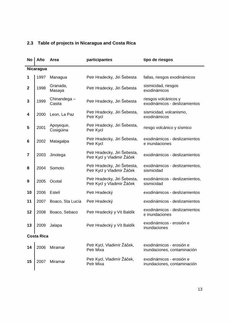
2.3 Table of projects in Nicaragua and Costa Rica
No Año Area participantes tipo de riesgos
Nicaragua
1 1997 Managua Petr Hradecky, Jiri Šebesta fallas, riesgos exodinámicos
2 1998 Granada, Masaya
Petr Hradecky, Jiri Šebesta sismicidad, riesgos exodinámicos
3 1999 Chinandega – Casita
Petr Hradecky, Jiri Šebesta riesgos volcánicos y exodinámicos - deslizamientos
4 2000 Leon, La Paz Petr Hradecky, Jiri Šebesta, Petr Kycl
sismicidad, volcanismo, exodinámicos
5 2001 Apoyeque, Cosigüina
Petr Hradecky, Jiri Šebesta, Petr Kycl
riesgo volcánico y sísmico
6 2002 Matagalpa Petr Hradecky, Jiri Šebesta, Petr Kycl
exodinámicos - deslizamientos e inundaciones
7 2003 Jinotega Petr Hradecky, Jiri Šebesta, Petr Kycl y Vladimir Žáček
exodinámicos - deslizamientos
8 2004 Somoto Petr Hradecky, Jiri Šebesta, Petr Kycl y Vladimir Žáček
exodinámicos - deslizamientos, sismicidad
9 2005 Ocotal Petr Hradecky, Jiri Šebesta, Petr Kycl y Vladimir Žáček
exodinámicos - deslizamientos, sismicidad
10 2006 Estelí Petr Hradecký exodinámicos - deslizamientos
11 2007 Boaco, Sta Lucía Petr Hradecký exodinámicos - deslizamientos
12 2008 Boaco, Sebaco Petr Hradecký y Vít Baldík exodinámicos - deslizamientos e inundaciones
13 2009 Jalapa Petr Hradecký y Vít Baldík exodinámicos - erosión e inundaciones
Costa Rica
14 2006 Miramar Petr Kycl, Vladimír Žáček, Petr Mixa
exodinámicos - erosión e inundaciones, contaminación
15 2007 Miramar Petr Kycl, Vladimír Žáček, Petr Mixa
exodinámicos - erosión e inundaciones, contaminación

14
16 2008 Chapernal Petr Kycl, Vladimír Žáček, Petr Mixa
exodinámicos - erosión e inundaciones, contaminación
17 2009 Juntas Petr Kycl, Vladimír Žáček, Petr Mixa
exodinámicos - erosión e inundaciones, contaminación
15
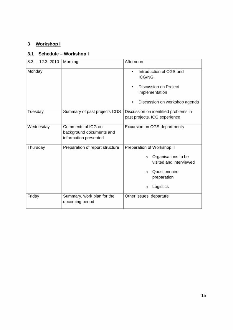
3 Workshop I
3.1 Schedule – Workshop I
8.3. – 12.3. 2010 Morning Afternoon
Monday • Introduction of CGS and ICG/NGI
• Discussion on Project implementation
• Discussion on workshop agenda
Tuesday Summary of past projects CGS Discussion on identified problems in past projects, ICG experience
Wednesday Comments of ICG on background documents and information presented
Excursion on CGS departments
Thursday Preparation of report structure Preparation of Workshop II
o Organisations to be visited and interviewed
o Questionnaire preparation
o Logistics
Friday Summary, work plan for the upcoming period
Other issues, departure

16
3.2 Technical note NGI – Material for 1 st workshop in Prague
3.2.1 Introduction This technical note is a compilation of material that may be useful during the 1st workshop in Prague during week 10, 2010.
A list of key aspects that may be useful to discuss is presented as well as a list of articles prepared by the International Centre for Geohazards (ICG) and relevant to the type of cooperation activities of the present project.
3.2.2 Key aspects for discussion during the worksho p
1. What drives the interest for cooperation?
a. Helping others?
b. Learning from others?
c. Learning from others by helping others?
d. Etc.
2. Scales of cooperation:
a. Institutional scale: one recipient partner or many recipient partners (independent or as a network).
b. Geographical scale of the target location: local, municipal, region (in one country), national, regional (many neighbouring countries).
c. Disciplinary scale: one discipline or multi-disciplinary.
d. Time scale: event-based or continuous.
3. Type of results:
a. Measurable (material): technical, databases, maps, etc.
b. Non-measurable (non-material): improving organizational capacity in partner(s) (routines for communications, decision-making, etc.), creating organizational units for dealing with problems
4. How can we identify the needs in the target location?
17
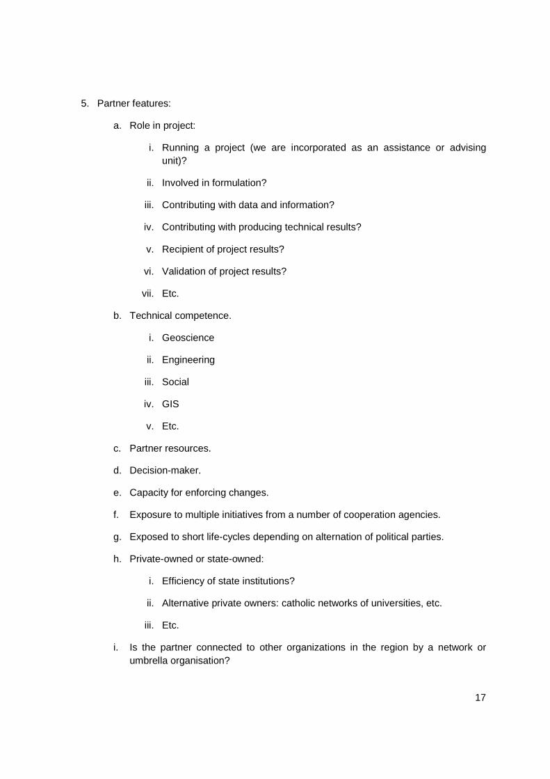
5. Partner features:
a. Role in project:
i. Running a project (we are incorporated as an assistance or advising unit)?
ii. Involved in formulation?
iii. Contributing with data and information?
iv. Contributing with producing technical results?
v. Recipient of project results?
vi. Validation of project results?
vii. Etc.
b. Technical competence.
i. Geoscience
ii. Engineering
iii. Social
iv. GIS
v. Etc.
c. Partner resources.
d. Decision-maker.
e. Capacity for enforcing changes.
f. Exposure to multiple initiatives from a number of cooperation agencies.
g. Exposed to short life-cycles depending on alternation of political parties.
h. Private-owned or state-owned:
i. Efficiency of state institutions?
ii. Alternative private owners: catholic networks of universities, etc.
iii. Etc.
i. Is the partner connected to other organizations in the region by a network or umbrella organisation?

18
6. Administration of project (assuming funding from a cooperation agency):
a. Bilateral: partner-us (JICA, USAID)
b. Multilateral: partner-bureaucratic agency at target location-us (others through CEPREDENAC)
c. Etc.
7. Modes of dissemination of results.
a. Journal papers
b. Conference papers
c. Workshops
d. Maps
e. Institutional reports
f. Guidelines
g. Website
h. Etc.
8. Sustainability of results:
a. Ensure adequate dissemination
b. Empowerment of results by partner (linked to the role of the partner)
c. Use/create international repositories of data and information (CRID: http://www.crid.or.cr/crid/ing/index_ing.html)
d. Etc.
9. Spin-off relations: with UN, EU organisations, World Bank, etc.
10. Present details of ICG experience in a selection of cases:
a. Use RECLAIMM combined with work in Graziella Devoli and JMC theses to illustrate Central American experience.
b. Use a South-east Asian project also (possibly one including multi-hazards: tsunami, landslides, etc.)
c. Others

19
3.2. List of presentations - Workshop I
NGI offers optimum solutions for industry and society Jose Cepeda
ICG – International Centre for Geohazards - overview Jose Cepeda, Bjorn Kalsnes
Investigación geológica de riesgos en un área de la cordillera Tilarán
Petr Kycl
Projects in Nicaragua – 1997-2009, cooperation with INETER Petr Hradecký
Characterisation and risk management of rainfall-induced landslides
José Cepeda
Project activities of the CGS in Central America 1997-2010 Petr Hradecký
Vulnerabilidad a los desastres de origen natural y estrategias de adaptación en la parte alta de las cuencas de los ríos Chira y Piura
Jiří Šebesta, Tomáš Hroch
Czech Cooperation in El Salvador Jiří Šebesta
Results of project “Building of capacity in landslide risk management in Central America” RECLAIM
Jose Cepeda, Bjorn Kalsnes
Metamorphic evolution rocks in the contact aureole of the Dipilto batholith
David Buriánek

20
4. Workshop II
4.2. Schedule of Workshop II
day date time organization addressed
coordinator contact place theme, details
day 1 23.5. Sun
20:00 arrival of ICG and CGS experts
day 2 24.5. Mon
8:00-16:00 INETER Antonio Álvarez [email protected]
INETER Managua Posibilidades de continuar el Proyecto, con ayuda de Noruegos. El problema mayor es financimiento.
day 3 25.5. Tue
8:00-16:00 INETER Antonio Álvarez [email protected]
INETER Managua implementación de datos conseguidos de proyectos ya realizados, en este caso, aprovechar la cooperación y experiencia de Noruegos
day 4 26.5. Wed
7:00-18:00 Municipalities Eduardo Escobar García
[email protected] Matagalpa Alcaldía de Matagalpa, donde se utilizan mapas de CGS del Proyecto etapa 2002
day 5 27.5. Thu
8:00-12:00 SINAPRED J. Ramon Arnesto Sota
[email protected] Managua
day 6 28.5. Fri
8:00-16:00 working session ČGS-ICG Managua
day 7 29.5. Sat
8:35 morning transfer to San Jose 11:00 Elections for the Parliament of CZ on Embassy of Czech Republic
day 8 30.5. Sun
7:00-18:00 free time -
day 9 31.5. Mon
9:00-16:00 DGM, CNE Francisco Castro M., Sofía Huapaya, Yoanna Mendez,
[email protected] office of DGM San Pedro, San Jose, Apartado
The main partner for CGS projects. Open discussion
day 10
1.6. Tue
9:00-12:00 UCR Rolando Mora University UCR, San Pedro
Involvement of students on projects
14:00-17:00
Embassy of Czech Republic
Jirina Sykorova Ivan Dubovický
[email protected] Embassy of Czech Rep.
Role of Embassy in the international projects
day 11
2.6. Wed
6:00-20:00 ICE Alberto Vásquez [email protected] Miravalles Proyecto geotérmico - improvement of geological data for energy balance of Costa Rica.
day 12
3.6. Thu
7:00-12:00 12:00-16:00
Municipalities José Miguel Díaz [email protected] Municipality Miramar, Juntas??
Implementation of geological results in mapping area. Map sheet Miramar and Juntas. Compatibility of systems GIS. Land-use planning.
day 13
4.6. Fri
12:00 departure - Jose Cepeda
day 14
5.6. Sat
8:00-15:00 departure Czech

21
Workshop II – detailed schedule for Nicaragua
lunes martes miercoles jueves
Grupo A
9:00 Visita GEONICA
Guillermo Chávez
Grupo B
9:00
EU
a.m. Introducción
Planificación de semana
11:00 Oficina SIG – experiencia con datos (Alex)
Evaluación y discusión de proyectos
Grupo A
7:00 – 9:00
viaje a Matagalpa
11:00 Recorrido a sitios identificados por Alcaldía
Introducción
INETER
8:00-10:00
Resumen del día anterior
10:00-12:00
Presentación de resumenes (AM, FS, AA)
Grupo A
Listado de proyectos
Evalución,
discusión
Grupo B
2:00
DIPECHO
PM, PH, IS
2:00
SINAPRED
Félix Hernández
Resumen de evaluación
Proyectos 2002, 2008
Discutir proyectos
Cuestionario
Discusión final
15-17:00 viaje
Grupo B
5:00-11:00
Honduras COPECO
DEFOMIN
PK, VZ, PM
Alcaldía San Marcos
p.m.
Aspectos logísticos para toda la semana
PK, JS, AA
AA va a contactar Invitar a Alcalde a discusión final
Confirmar la cita con Iván Guerrero
2:00 – 4:00
Discusión de futuros proyectos
Varios
22
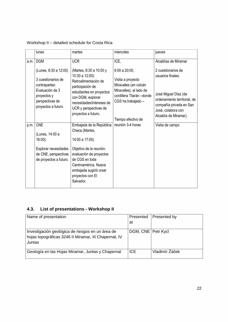
Workshop II – detailed schedule for Costa Rica
lunes martes miercoles jueves
a.m. DGM
(Lunes, 8:30 a 12:00)
3 cuestionarios de
contrapartes:
Evaluación de 3
proyectos y
perspectivas de
proyectos a futuro
UCR
(Martes, 8:30 a 10:00 y
10:30 a 12:00):
Retroalimentación de
participación de
estudiantes en proyectos
con DGM, explorar
necesidades/intereses de
UCR y perspectivas de
proyectos a futuro.
Alcaldías de Miramar
2 cuestionarios de
usuarios finales.
José Miguel Díaz (de
ordenamiento territorial, de
compañía privada en San
José, colabora con
Alcaldía de Miramar).
p.m. CNE
(Lunes, 14:00 a
16:00):
Explorar necesidades
de CNE, perspectivas
de proyectos a futuro.
Embajada de la República
Checa (Martes,
14:00 a 17:00).
Objetivo de la reunión:
evaluación de proyectos
de CGS en toda
Centroamérica. Nueva
embajada sugirió crear
proyectos con El
Salvador.
ICE,
6:00 a 20:00,
Visita a proyecto
Miravalles (en volcán
Miravalles), al lado de
cordillera Tilarán –donde
CGS ha trabajado –
Tiempo efectivo de
reunión 3-4 horas Visita de campo
4.3. List of presentations - Workshop II
Name of presentation Presented at
Presented by
Investigación geológica de riesgos en un área de hojas topográficas 3246 II Miramar, III Chapernal, IV Juntas
DGM, CNE Petr Kycl
Geología en las Hojas Miramar, Juntas y Chapernal ICE Vladimír Žáček

23
4.4. List of contacts at institutions visited durin g Workshop II in Central
America (20 May – 5 June 2010)
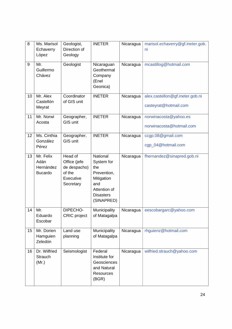
No.
Name Position Institution Country Email
1 Mr. Herman Rosa Chávez
Minister Ministry of Environment and Natural Resources (MARN)
El Salvador
2 Ms. Ana Deisy López Ramos
Director National Service of Territorial Studies (SNET)
El Salvador
3 Mr. Manuel Díaz
Director of Geology
SNET El Salvador
4 Ms. Margarita Minero
CEO Office for Urban Planning of the Metropolitan Area of San Salvador (OPAMSS)
El Salvador
5 Ms. Celina Cruz
Assistant Manager (subdirectora) of Control
(OPAMSS El Salvador
6 Ms. Angélica Muñoz, MSc
General manager (directora general) of Geophysics
Nicaraguan Institute of Territorial Studies (INETER)
Nicaragua [email protected]
7 Mr. Antonio Álvarez, MSc
Coordinator of Geology
INETER Nicaragua [email protected]
24
8 Ms. Marisol Echaverry López
Geologist, Direction of Geology
INETER Nicaragua [email protected]
9 Mr. Guillermo Chávez
Geologist Nicaraguan Geothermal Company (Enel Geonica)
Nicaragua [email protected]
10 Mr. Alex Castellón Meyrat
Coordinator of GIS unit
INETER Nicaragua [email protected]
11 Mr. Norwi Acosta
Geographer, GIS unit
INETER Nicaragua [email protected]
12 Ms. Cinthia González Pérez
Geographer, GIS unit
INETER Nicaragua [email protected]
13 Mr. Felix Adán Hernández Bucardo
Head of Office (jefe de despacho) of the Executive Secretary
National System for the Prevention, Mitigation and Attention of Disasters (SINAPRED)
Nicaragua [email protected]
14 Mr. Eduardo Escobar
DIPECHO-CRIC project
Municipality of Matagalpa
Nicaragua [email protected]
15 Mr. Dorien Hamguien Zeledón
Land use planning
Municipality of Matagalpa
Nicaragua [email protected]
16 Dr. Wilfried Strauch (Mr.)
Seismologist Federal Institute for Geosciences and Natural Resources (BGR)
Nicaragua [email protected]

25
17 Mr. José Francisco Castro Muñoz
Director Direction of Geology and Mines (DGM)
Costa Rica
18 Ms. Marlene Salazar Alvarado, MSc
Assistant manager (subdirectora)
DGM Costa Rica
19 Ms. Ana Sofía Huapaya
Coordinator of Mining
DGM Costa Rica
20 Mr. Óscar A. Lücke
Head of Department of Prevention and Mitigation
National Commision of Risk Prevention and Attention of Emergencies (CNE)
Costa Rica
21 Ms. Joanna Méndez Herrera
Geologist CNE Costa Rica
22 Ms. Daniela Herra Herrera
Geologist CNE Costa Rica
23 Mr. Ignacio Chaves Sala
Geologist CNE Costa Rica
24 Mr. Sergio Sánchez C.
- CNE Costa Rica
25 Mr. Hugo A. Sánchez S.
- CNE Costa Rica
26 Mr. Guido Matamoros
- CNE Costa Rica
27 Mr. Rolando Mora
Director School of
University of Costa Rica
Costa Rica
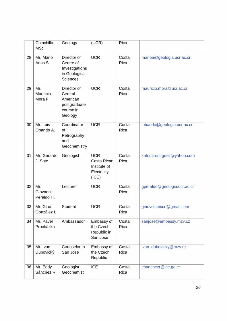
26
Chinchilla, MSc
Geology (UCR) Rica
28 Mr. Mario Arias S.
Director of Centre of Investigations in Geological Sciences
UCR Costa Rica
29 Mr. Mauricio Mora F.
Director of Central American postgraduate course in Geology
UCR Costa Rica
30 Mr. Luis Obando A.
Coordinator of Petrography and Geochemistry
UCR Costa Rica
31 Mr. Gerardo J. Soto
Geologist UCR – Costa Rican Institute of Electricity (ICE)
Costa Rica
32 Mr. Giovanni Peraldo H.
Lecturer UCR Costa Rica
33 Mr. Gino González I.
Student UCR Costa Rica
34 Mr. Pavel Procházka
Ambassador Embassy of the Czech Republic in San José
Costa Rica
35 Mr. Ivan Dubovický
Counselor in San José
Embassy of the Czech Republic
Costa Rica
36 Mr. Eddy Sánchez R.
Geologist-Geochemist
ICE Costa Rica

27
37 Mr. Fernando Molina Z.
Geologist ICE Costa Rica
38 Mr. Leonardo Solís S.
Geologist, Geochemistry area
ICE Costa Rica
39 Mr. Hugo Fajardo T.
Geologist ICE Costa Rica
40 Mr. Dagoberto Herrera C
Geologist-Geophysicist
ICE Costa Rica
41 Mr.Eduardo Vega
Geologist ICE Costa Rica
42 Mr. Álvaro Jiménez Cruz
Major Municipality of Montes de Oro
Costa Rica
43 Ms. Andrea Bolaños Calderón
Architect Municipality of Montes de Oro
Costa Rica
44 Ms. Floribeth Rojas Campos
Engineer Municipality of Montes de Oro
Costa Rica
45 Mr. Gustavo Torres Fernández
Informatics Municipality of Montes de Oro
Costa Rica
46 Mr. Víctor Cortés V.
Inspection Municipality of Montes de Oro
Costa Rica
-
47 Mr. José Miguel Díaz Miranda
Geologist GAPRO S.A. Costa Rica
48 Mr. Rolando Marín Monge
GIS GAPRO S.A. Costa Rica

28
Lists of persons who answered questionnaires.
Name Institution
Type (see note below)
Antonio Álvarez INETER CP
Marisol Echaverry INETER CP
Marta Navarro INETER CP
Wilfried Strauch INETER from 1992 to 2008 CP
Graziella Devoli INETER from 1999 to 2003 CP
Graziella Devoli 2003 – 2008: PhD student, University of Oslo; 2008-2009: NGI, Norway
EU
Guillermo Chávez GeoNica EU
Sofía Huapaya DGM - MINAET CP
Gino González Ilama University of Costa Rica CP
José Miguel Díaz Miranda
GAPRO, S.A. EU
Note:
CP – counterpart
EU – end user
4.5. Example of questionnaires.
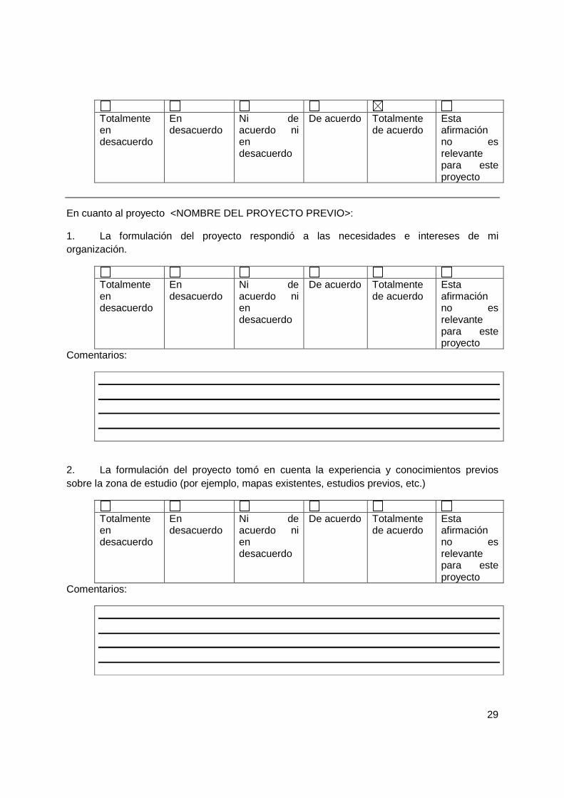
Counterpart questionnaire:
Sondeo de opinión para organizaciones centroamerica nas que han estado involucradas con proyectos del Servicio Geológico Checo (SGC)
Indicaciones: por favor complete este sondeo de opinión seleccionando una de las 6 opciones a cada afirmación y dando comentarios a su respuesta cuando lo considere necesario.
Ejemplo:
29
Totalmente en desacuerdo
En desacuerdo
Ni de acuerdo ni en desacuerdo
De acuerdo Totalmente de acuerdo
Esta afirmación no es relevante para este proyecto
En cuanto al proyecto <NOMBRE DEL PROYECTO PREVIO>:
1. La formulación del proyecto respondió a las necesidades e intereses de mi organización.
Totalmente en desacuerdo
En desacuerdo
Ni de acuerdo ni en desacuerdo
De acuerdo Totalmente de acuerdo
Esta afirmación no es relevante para este proyecto
Comentarios:
2. La formulación del proyecto tomó en cuenta la experiencia y conocimientos previos sobre la zona de estudio (por ejemplo, mapas existentes, estudios previos, etc.)
Totalmente en desacuerdo
En desacuerdo
Ni de acuerdo ni en desacuerdo
De acuerdo Totalmente de acuerdo
Esta afirmación no es relevante para este proyecto
Comentarios:
30
3. Personal técnico (geólogos, ingenieros, etc.) de mi organización estuvo activamente involucrado en aspectos técnicos de la formulación del proyecto.
Totalmente en desacuerdo
En desacuerdo
Ni de acuerdo ni en desacuerdo
De acuerdo Totalmente de acuerdo
Esta afirmación no es relevante para este proyecto
Comentarios:
4. La ejecución del proyecto estuvo armonizada con otros proyectos similares y/o complementarios realizados en forma simultánea en mi organización.
Totalmente en desacuerdo
En desacuerdo
Ni de acuerdo ni en desacuerdo
De acuerdo Totalmente de acuerdo
Esta afirmación no es relevante para este proyecto
Comentarios:
5. Personal técnico (geólogos, ingenieros, etc.) de mi organización estuvo activamente involucrado en aspectos técnicos de la ejecución del proyecto.
Totalmente en desacuerdo
En desacuerdo
Ni de acuerdo ni en desacuerdo
De acuerdo Totalmente de acuerdo
Esta afirmación no es relevante para este proyecto

31
Comentarios:
6. El proyecto ha producido un crecimiento en la capacidad técnica de mi organización a nivel institucional.
Totalmente en desacuerdo
En desacuerdo
Ni de acuerdo ni en desacuerdo
De acuerdo Totalmente de acuerdo
Esta afirmación no es relevante para este proyecto
Comentarios:
7. Actualmente en mi organización existe al menos un técnico (geólogo, ingeniero, etc.) con conocimiento de las técnicas usadas en el proyecto y de los productos del mismo.
Totalmente en desacuerdo
En desacuerdo
Ni de acuerdo ni en desacuerdo
De acuerdo Totalmente de acuerdo
Esta afirmación no es relevante para este proyecto
Comentarios:
32
8. En mi organización, los productos del proyecto están disponibles en forma impresa y/o en forma electrónica para los técnicos de mi organización.
Totalmente en desacuerdo
En desacuerdo
Ni de acuerdo ni en desacuerdo
De acuerdo Totalmente de acuerdo
Esta afirmación no es relevante para este proyecto
Comentarios:
9. En mi organización, los productos del proyecto están disponibles en forma impresa y/o en forma electrónica para usuarios finales fuera de mi organización (consultores, ONGs, otras organizaciones, público en general).
Totalmente en desacuerdo
En desacuerdo
Ni de acuerdo ni en desacuerdo
De acuerdo Totalmente de acuerdo
Esta afirmación no es relevante para este proyecto
Comentarios:
10. Los productos del proyecto son usados por técnicos de mi organización.
Totalmente en desacuerdo
En desacuerdo
Ni de acuerdo ni en desacuerdo
De acuerdo Totalmente de acuerdo
Esta afirmación no es relevante para este proyecto

33
Comentarios:
11. Los productos del proyecto son usados por usuarios finales fuera de mi organización (consultores, ONGs, otras organizaciones, público en general).
Totalmente en desacuerdo
En desacuerdo
Ni de acuerdo ni en desacuerdo
De acuerdo Totalmente de acuerdo
Esta afirmación no es relevante para este proyecto
Comentarios:
12. Por favor comente otros aspectos que usted considere importantes de cara a la experiencia de su organización con este proyecto del SGC.
End user questionnaire:
Sondeo de opinión para usuarios finales de producto s de proyectos del Servicio Geológico Checo (SGC).
Indicaciones: por favor complete este sondeo de opinión seleccionando una de las 6 opciones a cada afirmación y dando comentarios a su respuesta cuando lo considere necesario.

34
Ejemplo:
Totalmente en desacuerdo
En desacuerdo
Ni de acuerdo ni en desacuerdo
De acuerdo Totalmente de acuerdo
Esta afirmación no es relevante para este proyecto
En cuanto al producto <NOMBRE DEL PRODUCTO (MAPA, INFORME, REPORT, ETC.)>:
1. El producto usa convenciones de nombres, terminología, simbología, etc. adaptados a la práctica profesional.
Totalmente en desacuerdo
En desacuerdo
Ni de acuerdo ni en desacuerdo
De acuerdo Totalmente de acuerdo
Esta afirmación no es relevante para este proyecto
Comentarios:
2. El producto está disponible/accesible en forma adecuada.
Totalmente en desacuerdo
En desacuerdo
Ni de acuerdo ni en desacuerdo
De acuerdo Totalmente de acuerdo
Esta afirmación no es relevante para este proyecto
Comentarios:
35
3. El contenido del producto está armonizado con otros productos cartográficos o estudios disponibles para la misma región en lo que respecta a proyección, escala, simbología, terminología, etc.
Totalmente en desacuerdo
En desacuerdo
Ni de acuerdo ni en desacuerdo
De acuerdo Totalmente de acuerdo
Esta afirmación no es relevante para este proyecto
Comentarios:
4. Toda la información proporcionada por el producto es útil para mi práctica profesional.
Totalmente en desacuerdo
En desacuerdo
Ni de acuerdo ni en desacuerdo
De acuerdo Totalmente de acuerdo
Esta afirmación no es relevante para este proyecto
Comentarios:
5. Por favor comente otros aspectos que usted considere importantes de cara a su experiencia con este producto del SGC.
36
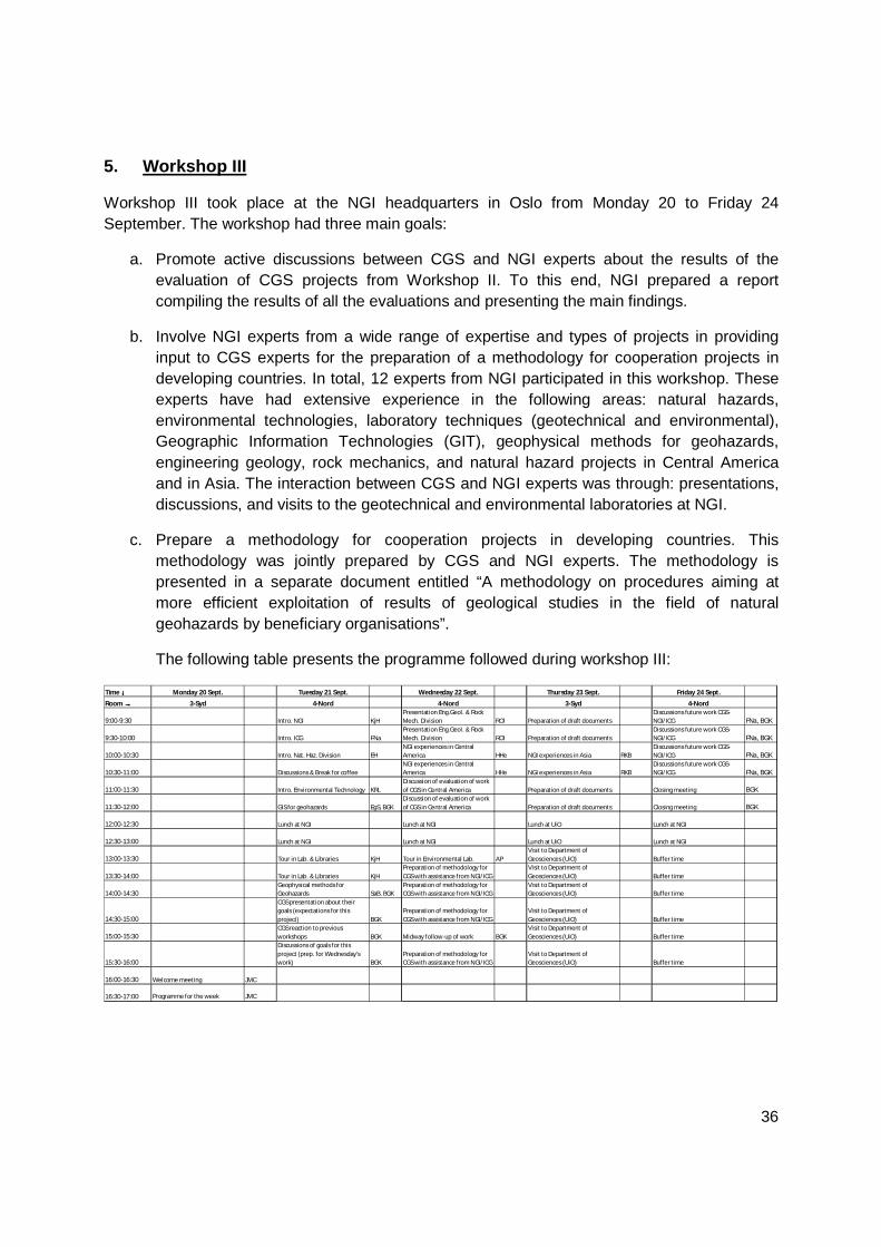
5. Workshop III
Workshop III took place at the NGI headquarters in Oslo from Monday 20 to Friday 24 September. The workshop had three main goals:
a. Promote active discussions between CGS and NGI experts about the results of the evaluation of CGS projects from Workshop II. To this end, NGI prepared a report compiling the results of all the evaluations and presenting the main findings.
b. Involve NGI experts from a wide range of expertise and types of projects in providing input to CGS experts for the preparation of a methodology for cooperation projects in developing countries. In total, 12 experts from NGI participated in this workshop. These experts have had extensive experience in the following areas: natural hazards, environmental technologies, laboratory techniques (geotechnical and environmental), Geographic Information Technologies (GIT), geophysical methods for geohazards, engineering geology, rock mechanics, and natural hazard projects in Central America and in Asia. The interaction between CGS and NGI experts was through: presentations, discussions, and visits to the geotechnical and environmental laboratories at NGI.
c. Prepare a methodology for cooperation projects in developing countries. This methodology was jointly prepared by CGS and NGI experts. The methodology is presented in a separate document entitled “A methodology on procedures aiming at more efficient exploitation of results of geological studies in the field of natural geohazards by beneficiary organisations”.
The following table presents the programme followed during workshop III:
Time ↓↓↓↓ Monday 20 Sept. Tuesday 21 Sept. Wednesday 22 Sept. Th ursday 23 Sept. Friday 24 Sept.
Room →→→→ 3-Syd 4-Nord 4-Nord 3-Syd 4-Nord
9:00-9:30 Intro. NGI KjHPresentation Eng.Geol. & Rock Mech. Division ROl Preparation of draft documents
Discussions future work CGS-NGI/ ICG FNa, BGK
9:30-10:00 Intro. ICG FNaPresentation Eng.Geol. & Rock Mech. Division ROl Preparation of draft documents
Discussions future work CGS-NGI/ ICG FNa, BGK
10:00-10:30 Intro. Nat. Haz. Division EHNGI experiences in Central America HHe NGI experiences in Asia RKB
Discussions future work CGS-NGI/ ICG FNa, BGK
10:30-11:00 Discussions & Break for coffeeNGI experiences in Central America HHe NGI experiences in Asia RKB
Discussions future work CGS-NGI/ ICG FNa, BGK
11:00-11:30 Intro. Environmental Technology KRLDiscussion of evaluation of work of CGS in Central America Preparation of draft documents Closing meeting BGK
11:30-12:00 GIS for geohazards EgS, BGKDiscussion of evaluation of work of CGS in Central America Preparation of draft documents Closing meeting BGK
12:00-12:30 Lunch at NGI Lunch at NGI Lunch at UiO Lunch at NGI
12:30-13:00 Lunch at NGI Lunch at NGI Lunch at UiO Lunch at NGI
13:00-13:30 Tour in Lab. & Libraries KjH Tour in Environmental Lab. APVisit to Department of Geosciences (UiO) Buffer time
13:30-14:00 Tour in Lab. & Libraries KjHPreparation of methodology for CGS with assistance from NGI/ ICG
Visit to Department of Geosciences (UiO) Buffer time
14:00-14:30Geophysical methods for Geohazards SaB, BGK
Preparation of methodology for CGS with assistance from NGI/ ICG
Visit to Department of Geosciences (UiO) Buffer time
14:30-15:00
CGS presentation about their goals (expectations for this project) BGK
Preparation of methodology for CGS with assistance from NGI/ ICG
Visit to Department of Geosciences (UiO) Buffer time
15:00-15:30CGS reaction to previous workshops BGK Midway follow-up of work BGK
Visit to Department of Geosciences (UiO) Buffer time
15:30-16:00
Discussions of goals for this project (prep. for Wednesday's work) BGK
Preparation of methodology for CGS with assistance from NGI/ ICG
Visit to Department of Geosciences (UiO) Buffer time
16:00-16:30 Welcome meeting JMC
16:30-17:00 Programme for the week JMC
37
6. Evaluation
6.2. Methodology of evaluations
The Norwegian Geotechnical Institute (NGI) prepared two types of questionnaires: one
for counterpart institutions and a second one for end users. Each item in the questionnaires
consisted of a sentence which had a closed-type of answer ranging from “Fully agree” to “Fully
disagree” (5 levels in total) and an answer of “Non applicable”. Additionally, the person
answering the questionnaire had the possibility to give comments to each item, and an open
question at the end of the questionnaire for providing comments in other aspects not mentioned
in the evaluation. The questionnaires were handed out to the persons at the institutions visited
during Workshop II and also sent by email.
It should be noted that these evaluations are essentially measuring perceptions of the
interviewed persons about CGS projects and their products.
The questionnaire for counterpart institutions was evaluating three aspects of the
projects: formulation, execution and dissemination.
The end user questionnaire was addressing three main aspects of the results of the
projects: the compatibility with existing conventions and data, the practical use of the results,
and the availability of products.
6.3. Main results of evaluations
An important aspect to remark is that the answers to these questionnaires should be
interpreted with caution due to the following:
• The persons answering these questionnaires had varying degrees of involvement
and knowledge in the CGS projects (i.e., some persons had been very actively
and continuously involved in the projects, while others had been working only
sporadically).
• While some persons had a complete perspective of the 13 years of cooperation
of CGS in the region, others had a perspective of only a few years of project
activity.
• The differences in background and experience of the interviewed persons
seemed to influence their perceptions of the projects. NGI could notice that

38
persons with a solid background in Geosciences and with several years of
experience had an overall positive perception of the CGS projects.
The following main aspects were extracted by NGI from an interpretation of the
evaluations:
a) The overall perception is that the CGS projects have produced very useful results
for the counterpart institutions and end users in the recipient countries. The basic
and thematic maps produced during the projects contain significant data and
information for practitioners.
b) The formulation stage of the projects has adequately taken into account the
interests and needs of the counterparts institutions.
c) A minimum basic technical competence and experience of the technicians from
the counterpart institutions seems to be a key aspect for ensuring a thorough and
active involvement of these technicians during the execution of the projects.
d) The building of capacity at the counterpart institutions seems to be hindered
when the mobility of their technicians is high.
e) The dissemination of map products from counterparts to end users should
consider not only hardcopies and figure formats, but also vector or raster formats
that can be directly used by GIS software. Of course, this aspect is strongly
dependant on the dissemination policies at the counterpart institution.
f) Involvement of more than one counterpart institution seems to be desirable in
order to ensure sustainability, continuity and extended dissemination of products
and technical capacity.
g) Both the counterpart and end user institutions agreed on the interest and
necessity of new projects for producing basic and thematic maps for other parts
of the countries or at different scales.
h) National and institutional policies for international cooperation at the recipient
countries have evolved over the years towards capacity-building and equal-to-
equal styles. These styles need to be taken into account in the formulation of
new projects.

39
7. Annex I - photos
Workshop I – Prague
Czech Embassy – with ambassador Mr. P. Procházka

40
ICE – geothermal project
San Marcos de Colón – consultations on continuation of project