an integrated habitat classification and map of the lake...
TRANSCRIPT

An Integrated Habitat Classification and An Integrated Habitat Classification and Map of the Lake Erie BasinMap of the Lake Erie Basin
Building Expertise and CooperationBuilding Expertise and Cooperation
L.B. Johnson, S.D. Mackey, T. Hollenhorst, J.J.H. L.B. Johnson, S.D. Mackey, T. Hollenhorst, J.J.H. Ciborowski, D.T. Button, R. GauthierCiborowski, D.T. Button, R. Gauthier
Project Funded by the Project Funded by the U.S. EPA Great Lakes National Program OfficeU.S. EPA Great Lakes National Program Office

ObjectivesObjectives
Provide a framework for mapping and tracking Provide a framework for mapping and tracking habitat changes in the Lake Erie basin.habitat changes in the Lake Erie basin.Develop a unified, integrated habitat Develop a unified, integrated habitat classification system for Lake Erie.classification system for Lake Erie.Apply a common set of geospatial tools that Apply a common set of geospatial tools that integrate physical, chemical, and biological integrate physical, chemical, and biological environmental characteristics at multiple scales.environmental characteristics at multiple scales.Produce dynamic habitat maps as a function of Produce dynamic habitat maps as a function of the species, community, of ecological processes the species, community, of ecological processes of interest.of interest.

StrategyStrategy
Bring together a group of Experts with a diverse Bring together a group of Experts with a diverse range of backgrounds and expertise from range of backgrounds and expertise from agencies, academia, NGO’s, and private sector to:agencies, academia, NGO’s, and private sector to:
Identify and reach consensus on environmental zonesIdentify and reach consensus on environmental zonesIdentify critical “super variables” that are applicable Identify critical “super variables” that are applicable across multiple environmental zones.across multiple environmental zones.Identify and reach consensus on existing classification Identify and reach consensus on existing classification schemes and associated datasets that can be integrated schemes and associated datasets that can be integrated into a unified classification scheme for the basin.into a unified classification scheme for the basin.Assist with the development of geospatial tools that can Assist with the development of geospatial tools that can be applied to document ecosystem changes in the basinbe applied to document ecosystem changes in the basin

Environmental ZonesEnvironmental ZonesLand Data LayersLand Data Layers Water Data LayersWater Data Layers
••Terrestrial Terrestrial (forests, woodlots, (forests, woodlots, grasslands, palustrine grasslands, palustrine wetlands, and agricultural wetlands, and agricultural fields)fields)
••Coastal MarginCoastal Margin (shoreline, (shoreline, water column and substrate in water column and substrate in embayments embayments -- water depths 3 water depths 3 m or less)m or less)
••Inland Lakes and TributariesInland Lakes and Tributaries (streams, rivers, palustrine (streams, rivers, palustrine wetlands, and inland lakes)wetlands, and inland lakes)
••Nearshore OpenNearshore Open--WaterWater (water (water column and substrate column and substrate -- water water depths 3 m to 15 m)depths 3 m to 15 m)
••Wetlands Wetlands (coastal, riparian, (coastal, riparian, and palustrine wetlands)and palustrine wetlands)
••OpenOpen--Lake OffshoreLake Offshore (water (water column and substrate column and substrate -- water water depths 15 m and greater) depths 15 m and greater)
Hydrogeomorphic Characteristics and Dominant Physical ProcessesHydrogeomorphic Characteristics and Dominant Physical Processes

Land Data LayersLand Data Layers Water Data LayersWater Data Layers
““Super VariablesSuper Variables”” TerrestrialTerrestrial Inland Lakes &Inland Lakes &TribsTribs WetlandsWetlands Coastal MarginCoastal Margin NearshoreNearshore OffshoreOffshore
ElevationElevation TopographyTopography BathymetryBathymetry BathymetryBathymetry BathymetryBathymetry BathymetryBathymetry BathymetryBathymetry
SlopeSlope Land SurfaceLand Surface Water SurfaceWater Surface Bottom SlopeBottom Slope Bottom SlopeBottom Slope Bottom SlopeBottom Slope Bottom SlopeBottom Slope
EnergyEnergy Stream PowerStream Power Wave/CurrentsWave/Currents Wave/CurrentsWave/Currents Wave/CurrentsWave/Currents Wave/CurrentsWave/Currents
ClimateClimate Degree DaysDegree Days TemperatureTemperature TemperatureTemperature ThermalThermalStratificationStratification
ThermalThermalStratificationStratification
ThermalThermalStratificationStratification
Hydrography/Hydrography/GeomorphologyGeomorphology Drainage NetworkDrainage Network Drainage NetworkDrainage Network Wetland/Wetland/
ShorelineShoreline ShorelineShoreline LakebedLakebedStructureStructure
LakebedLakebedStructureStructure
Hydrology/Hydrology/HydraulicsHydraulics
PrecipitationPrecipitationRunoffRunoff
InfiltrationInfiltration
Flow Regime/Flow Regime/Water SourceWater Source
Water Levels/ Water Levels/ FlowFlow
Regime/ WaterRegime/ WaterSourceSource
Water Levels/Water Levels/Circulation/Circulation/OutwellingOutwelling
Water Levels/Water Levels/Circulation/Circulation/OutwellingOutwelling
Water Levels/Water Levels/Circulation/Circulation/OutwellingOutwelling
GeologyGeologySoils/SurficialSoils/Surficial
Materials/Materials/BedrockBedrock
Substrate/Substrate/Stability/Stability/BedrockBedrock
Substrate/Substrate/BedrockBedrock
Substrate/Substrate/Stability/Stability/BedrockBedrock
Substrate/Substrate/Stability/Stability/BedrockBedrock
Substrate/ Substrate/ Stability/Stability/BedrockBedrock
TurbidityTurbidityPoint and Point and NonNon--PointPointSourcesSources
SuspendedSuspendedSediment Load/Sediment Load/
TurbidityTurbidity
Turbidity/LightTurbidity/LightAttenuationAttenuation
Turbidity/LightTurbidity/LightAttenuationAttenuation
Turbidity/LightTurbidity/LightAttenuationAttenuation
Turbidity/LightTurbidity/LightAttenuationAttenuation
Water ChemistryWater ChemistryPoint and Point and NonNon--PointPointSourcesSources
Nutrients/Nutrients/ContaminantsContaminants
Nutrients/Nutrients/ContaminantsContaminants
Nutrients/Nutrients/ContaminantsContaminants
Nutrients/Nutrients/ContaminantsContaminants
Nutrients/Nutrients/ContaminantsContaminants
VegetationVegetation Land CoverLand Cover Submergent/Submergent/EmergentEmergent
Submergent/Submergent/EmergentEmergent
Submergent/Submergent/EmergentEmergent SubmergentSubmergent SubmergentSubmergent
Land CoverLand Cover AllAll Riparian/Riparian/UpstreamUpstream
Riparian/Riparian/UpstreamUpstream
Riparian/Riparian/Shoreline TypeShoreline Type
Common Environmental AttributesCommon Environmental Attributes

Lake Erie Basin
TerrestrialInland Lakes and TributariesWetlands
Offshore

Complexity within Environmental ZonesComplexity within Environmental Zones (Contentious Environmental Zones)(Contentious Environmental Zones)
EnvironmentalEnvironmentalZoneZone
Low Energy AreaLow Energy Area High Energy AreaHigh Energy Area
Coastal MarginCoastal Margin< 3 m< 3 m
Embayments, tributary Embayments, tributary mouths, coastal wetland mouths, coastal wetland
habitatshabitats
Open Coasts, island Open Coasts, island fringesfringes
Nearshore Open Nearshore Open WaterWater
3m 3m –– 15 m15 m
Open water area Open water area -- water water depths greater than 10 mdepths greater than 10 m
Open water area Open water area -- water water depth less than 10 m, depth less than 10 m,
shallow reef complexesshallow reef complexes
Limited ExposureLimited ExposureShort Fetch DistanceShort Fetch Distance
FineFine--grained, soft grained, soft substratessubstrates
Open ExposureOpen ExposureLong Fetch DistanceLong Fetch DistanceCoarseCoarse--grained, hard grained, hard substrates, bedrocksubstrates, bedrock
Hydrogeomorphic Characteristics and Dominant Physical ProcessesHydrogeomorphic Characteristics and Dominant Physical Processes

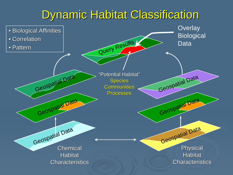
Dynamic Habitat Classification applied to Dynamic Habitat Classification applied to Environmental ZonesEnvironmental Zones
SpeciesSpecies--specific habitatsspecific habitatsare identified and delimited are identified and delimited by the intersection of by the intersection of particular range of physical, particular range of physical, chemical and biological chemical and biological attributes.attributes.
Considers both the Considers both the threethree--dimensional and dynamicdimensional and dynamicnature of aquatic habitats.nature of aquatic habitats.
PPreserves the original reserves the original geospatial data layersgeospatial data layers and and allows for periodic updates allows for periodic updates as new data become as new data become available. available.
EnergyEnergy
SubstrateSubstrate WaterWater MassMass
““HabitatHabitat””
((ClimateClimate))
((GeologyGeology)) ((HydrologyHydrology))
PhysicalPhysicalHabitatHabitat
CharacteristicsCharacteristics
ChemicalChemicalHabitatHabitat
CharacteristicsCharacteristics
““Potential Habitat”Potential Habitat”SpeciesSpecies
CommunitiesCommunitiesProcessesProcesses
Dynamic Habitat ClassificationDynamic Habitat Classification•• Biological Biological AffinitiesAffinities•• CorrelationCorrelation•• PatternPattern
Geospatial Data
Geospatial Data
Geospatial Data
Geospatial Data
Geospatial Data
Geospatial Data
OverlayBiologicalData
Query Results

Integrated Land Cover Integrated Land Cover –– Lake ErieLake Erie
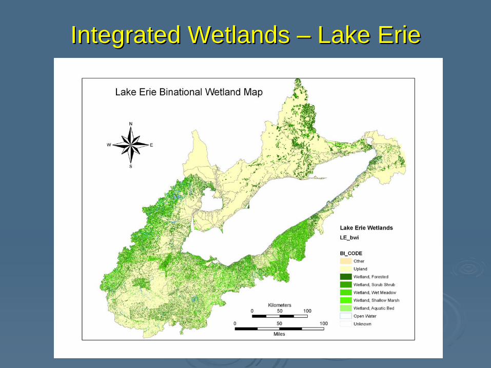
Integrated Wetlands Integrated Wetlands –– Lake ErieLake Erie

Integrated Substrate Integrated Substrate –– Lake ErieLake Erie

Fish Habitat Characteristics Fish Habitat Characteristics –– Lake ErieLake ErieWater DepthSlopeSubstrateCirculationTemperature (warm, cool)Proximity to Tributary Mouth

SummarySummaryInitial classification based on physical and chemical Initial classification based on physical and chemical attributes that regulate habitatattributes that regulate habitatSix major environmental zones with key environmental Six major environmental zones with key environmental attributesattributesIdentified “Super Variables” that are applicable to more Identified “Super Variables” that are applicable to more than one environmental zonethan one environmental zoneIdentified data gaps, dataset integration, and crossIdentified data gaps, dataset integration, and cross--walking needswalking needsDiscovered that data sharing policies need to be revised Discovered that data sharing policies need to be revised –– open source data access is requiredopen source data access is requiredUtilized a dynamic habitat classification approachUtilized a dynamic habitat classification approachProducts Products -- geospatially based dynamic classification geospatially based dynamic classification system, crosswalk tables, suite of derivative map system, crosswalk tables, suite of derivative map products to illustrate power of dynamic classification products to illustrate power of dynamic classification system approach system approach –– Maumee River, Ohio and Grand Maumee River, Ohio and Grand River OntarioRiver Ontario

Collaborative EffortCollaborative Effort30+ experts reached consensus on habitat 30+ experts reached consensus on habitat framework and classification for Lake Erie framework and classification for Lake Erie habitats.habitats.Avoided major conflicts by developing habitat Avoided major conflicts by developing habitat framework based on fundamental integrity framework based on fundamental integrity elements in the GLWQA.elements in the GLWQA.Minimized speciesMinimized species--specific competition by specific competition by developing dynamic classification scheme based developing dynamic classification scheme based on species, community, or ecological function of on species, community, or ecological function of interest interest –– made all species “equal”.made all species “equal”.Participants had equal standing, rank left at the Participants had equal standing, rank left at the door.door.Sharp objects not allowed into the conference Sharp objects not allowed into the conference room. room.

The Names have been Removed to The Names have been Removed to Protect the Innocent!Protect the Innocent!
http://http://www.lemn.orgwww.lemn.orghttp://http://www.glc.org/eriehabitatwww.glc.org/eriehabitat//