sediment oxygen demand in the central basin of lake erieweb2.uwindsor.ca/lemn/lemn2008_files/lemn...
TRANSCRIPT
Lake Erie
Great Lakes Regional Research Information Network Lake Erie Millennium Network Binational Research and Monitoring for the Millennium http://www.LEMN.org
THE FIFTH BIENNIAL CONFERENCE OF THE
LAKE ERIE MILLENNIUM NETWORK
29 April – 1 May 2008 University of Windsor
Windsor, Ontario, Canada
Convened by
Great Lakes Institute for Environmental Research, University of Windsor National Water Research Institute, Environment Canada
Ohio Sea Grant - F.T. Stone Laboratory, Ohio State University Great Lakes Research Station, U.S. Environmental Protection Agency at Grosse Ile
Program and Events

CONFERENCE ORGANIZING COMMITTEES
LAKE ERIE MILLENNIUM NETWORK Natalie Carreau Convener, University of Windsor Jan Ciborowski Convener, University of Windsor Russell Kreis Convener, Large Lakes Research Laboratory, US EPA, Grosse Ile Chris Marvin Convener, National Water Research Institute, Environment Canada Jeffrey Reutter Convener, Ohio Sea Grant & F. T. Stone Laboratory, Ohio State
University We gratefully acknowledge the following University of Windsor offices for hosting the Conference social events: President - Dr. Ross Paul Provost & Vice-President, Academic – Dr. Neil Gold Research - Dr. Ranjana Bird, Vice-president Faculty of Science - Dr. Richard Caron, Dean Great Lakes Institute for Environmental Research – Dr. Brian Fryer, Director

CONFERENCE PROGRAM THE FIFTH BIENNIAL CONFERENCE OF THE LAKE ERIE MILLENNIUM NETWORK Ambassador Auditorium, CAW Student Centre University of Windsor 29 April - 1 May 2008 MONDAY APRIL 28 5:00 - 6:00 p.m. Poster Set-up - CAW Student Centre, Commons Area 6:00 - 7:30 p.m. WELCOMING SOCIAL- CAW Student Centre, Commons Area Registration and informal mixer TUESDAY APRIL 29 8:00 a.m. Poster Set-up - CAW Student Centre, Commons Area 8:30 a.m. Welcoming Remarks and Introduction Richard J. Caron - Dean of Science J. Brian Fryer - Director, Great Lakes Institute for Environmental Research Jan J.H. Ciborowski - Co-convenor, Lake Erie Millennium Network Theme #1 - Trophic status of Lake Erie: nutrients, food web components; conditions of the
offshore zone Chris Marvin, National Water Research Institute, Environment Canada, Moderator 8:40 DAVID C. ROCKWELL, US EPA, GLNPO, R.P. Barbiero, Computer Sciences
Corporation, K. Schmude, M. Balcer, University of Wisconsin Superior, E. Reavie University of Minnesota Duluth
GLNPO Biology Program Lake Erie 1998-2007. 9:00 PAUL BERTRAM and J. May, EPA, GLNPO, Lake Erie dissolved oxygen - recent conditions. 9:15 SUE WATSON, NWRI, Environment Canada
Planktonic and benthic water quality and current issues 9:30 RAM R. YERUBANDI, NWRI, Environment Canada, N. Hawley, D. W. Schertzer,
NWRI, Environment Canada, Circulation, thermal structure and dissolved oxygen concentration in Lake Erie. 9:45 MICHAEL R. TWISS, Clarkson University, R.A. Bourbonniere, Environment
Canada/WSTD/AEIRD, G.S. Bullerjahn, Bowling Green State University, H.J. Carrick, Pennsylvania State University, N. D’Souza, P.C. Furey, R.M.L. McKay, Bowling Green State University, N.E. Ostrom, Michigan State University, M. Saxton, University of Tennessee, R.E.H. Smith, University of Waterloo and S.W. Wilhelm, University of Tennessee.
Winter assessment of microbial biomass and metabolism: February 2007 & 2008. 10:00 BREAK

10:15 KENNETH A. KRIEGER. National Center for Water Quality Research, Heidelberg
College The benthos of Lake Erie: current research directions and research needs. 10:30 NATHAN HAWLEY, NOAA/Great Lakes Environmental Research Laboratory.
Sediment transport observations in Lake Erie. 10:45 STEVEN A. RUBERG, R.W. Muzzi, S.B. Brandt, and N. Hawley, NOAA / Great
Lakes Environmental Research Laboratory, Research application and societal benefits of the real-time coastal observation network (ReCON).
11:00 THOMAS BRIDGEMAN & J. Chaffin Lake Erie Center, University of Toledo. Microcystis blooms in western Lake Erie 2002-2007
11:15 JEFFREY T. TYSON, Ohio Dept. of Natural Resources & T. MacDougall, Ontario Ministry of Natural Resources.
Status of the Lake Erie fish community, 2008. 11:30 LYNDA D. CORKUM. S.N. Dopazo, University of Windsor, N.E. Mandrak, & S.M.
Reid, Fisheries & Oceans Canada Fish assemblages in nearshore beaches of the Huron-Erie corridor and the north shore of Lake Erie. 11:45 Discussion and Comments 12:00 LUNCH Theme 2 - Linking land and lake in the Lake Erie basin: materials from the landscape;
condition of the coastal margin and nearshore; indicators and the status of habitat zones of the Lake Erie basin
Jeff Reutter, F.T. Stone Lab & Ohio State University, Moderator 1:00 SCUDDER D. MACKEY, University of Windsor Physical changes in nearshore habitat 1:15 SUSAN E. DOKA, Fisheries & Oceans Canada, L.D. Mortsch, University of Waterloo,
Environment Canada and A.J. Hebb University of Waterloo Vulnerability of lower great lakes coastal wetland communities to climate change. 1:30 HARVEY BOOTSMA, Great Lakes Water Institute
Benthic carbon and nutrient cycling at coastal margins. 1:45 R. PETER RICHARDS, D.B. Baker, and J.P. Crumrine, National Center for Water Quality Research, Heidelberg College
Trends in dissolved reactive phosphorus in Lake Erie tributaries. 2:00 CRAIG F. DRURY, J.Y. Yang, R. De Jong, Xueming M. Yang, E.C. Huffman,
Agriculture & Agri-Food Canada, and Keith Reid, Ontario Ministry of Agriculture, Food & Rural Affairs.
The development of the environmental indicators for nitrogen (residual soil nitrogen and the indicator of risk of water contamination of nitrate-N) and management practices which reduce nitrate losses
2:15 PATRICIA A. CHAMBERS, C. Vis, R.B. Brua, M. Guy, Environment Canada J.M. Culp, University of New Brunswick and G. Benoy, Agriculture & Agri-Food Canada
Water quality of Ontario agricultural streams: defining nutrient concentrations to prevent eutrophication

Fifth Biennial Lake Erie Millennium Network Conference April 29 – May 1, 2008
2:30 L.B. Johnson, TOM HOLLENHORST, G. Host, Natural Resources Research Institute, University of Minnesota Duluth, J.J.H. Ciborowski, University of Windsor, G.Niemi, and N. Danz, Natural Resources Research Institute, University of Minnesota Duluth
Multivariate summaries of great lake stressor loadings using watershed delineations at multiple scales
2:45 Jack Kelly, P. Yurista, J. and G. Peterson, Mid-Continent Ecology Division, U.S. EPA, Duluth
Finding signals of the landscape in coastal environments 3:00 BREAK
3:15 MURRAY N. CHARLTON, Burlington, ON Status of nutrients in Lake Erie 3:30 MARY ELLEN SCANLON, Ontario MOE – West Central Region, for the Lake Erie
LaMP Working Group Lake Erie LaMP’s binational nutrient management plan 3:45 Discussion and Comments Theme 3 - New and continuing research opportunities: Planning for the 2009 Intensive
Monitoring Year 4:00 PAMELA JOOSSE, Great Lakes Environmental Management Branch, Ontario Ministry
of Agriculture, Food and Rural Affairs Agri-environmental research and programs linking the land to the lake
4:15 VI RICHARDSON, Water Quality Monitoring & Surveillance, Environment Canada, and G. Warren, Great Lakes National Program Office, USEPA
Improving binational coordination of monitoring in the Great Lakes 4:30 PAUL HORVATIN, Great Lakes National Program Office, USEPA US EPA Research plans and opportunities 4:45 Close for the day 5:00-6:30 SOCIAL AND POSTER VIEWING Location: CAW Student Centre, Commons Area Supper on peoples' own
5

Fifth Biennial Lake Erie Millennium Network Conference April 29 – May 1, 2008
WEDNESDAY APRIL 30 Theme 4 - Biological and chemical contaminants: legacy and emerging issues: status and
understanding of persistent chemicals, pharmaceuticals, pathogens, invaders Russ Kreis, US EPA Large Lakes Research Lab, Moderator 8:45 JOSEPH F. KOONCE, Case Western Reserve University Why is it so difficult to couple landscape and nearshore processes? 9:00 ALICE DOVE, Environment Canada, Burlington Organic contaminants in Lake Erie offshore waters 9:15 DOUGLAS D. KANE, Defiance College, J.D. Conroy, D.A. Culver, Ohio State
University, R.P. Richards, and D.B. Baker, Heidelberg College Correlations between soluble reactive phosphorus (SRP) loading and phytoplankton biomass in the western basin of Lake Erie
9:30 KEN G. DROUILLARD, Great Lakes Institute for Environmental Research, University of Windsor
Recent trends in PCBs in western Lake Erie fish and wildlife 9:45 DEBBIE BURNISTON, C. Marvin, and J. Waltho, Environment Canada, Burlington,
ON New and emerging contaminants in lake Erie: tributary and open water sediment.
10:00 BREAK 10:30 J. Struger, DEBBIE BURNISTON, and C. Marvin, Environment Canada, Burlington,
ON Pesticide loadings from land 10:45 Mark A. Breederland, Michigan Sea Grant Extension, Traverse City
Type E Botulism: Issues & Impacts in Michigan 2006-2007. 11:00 BRENDA KOENIG, C. Brousseau, S. Kerr and E. Wright, Ontario Minstry of
Natural Resources, Peterborough, ON Baitfish and VHS in Ontario 11:15 FRANCISCO SYLVESTER, Great Lakes Institute for Environmental Research,
University of Windsor Hull fouling and its role as a vector for invasions in the Great Lakes 11:30 Discussion and Comments
11:45 LUNCH 12:55 Chip Weseloh, Canadian Wildlife Service (CWS), F. Cuthbert, University of
Minnesota, D.J. Moore, CWS, Linda Wires, University of Minnesota, M. Shieldcastle, Ohio DNR, C. Adams, New York State Dept. Environ. Conservation, and T. Dobbie, Parks Canada, Leamington
Colonial waterbirds in western Lake Erie: Recent numbers, contaminant levels and what’s happening with double-crested cormorants.
6

Fifth Biennial Lake Erie Millennium Network Conference April 29 – May 1, 2008
1:15 SAAD Y. JASIM, Walkerton Clean Water Centre, Walkerton, ON
The presence of pharmaceuticals, personal care products, and other contaminants in source water.
Theme 5 - Building expertise and cooperation: Lake Erie's research centres, facilities, and
opportunities for collaboration Jan Ciborowski, University of Windsor, Moderator
1:30 L.B. Johnson, Natural Resources Research Institute (NRRI), University of Minnesota
Duluth, SCUDDER D. MACKEY, University of Windsor T. Hollenhorst, NRRI, University of Minnesota Duluth, J.J.H. Ciborowski, University of Windsor, D.T. Button, US Geological Survey, Columbus, and R. Gauthier, Great Lakes Commission, Ann Arbor
An Integrated Habitat Classification and Map of the Lake Erie Basin 1:45 KAREN VIGMOSTAD, International Joint Commission, Windsor Regional Office.
Review of the GLWQA: Implications for Lake Erie 2:00 BRIAN J. FRYER, Great Lakes Institute for Environmental Research, University of
Windsor The Great Lakes Institute for Environmental Research (GLIER): Focused on Environmental Tracers
2:15 CAROL A. STEPIEN, Lake Erie Center, University of Toledo 2:30 JEFFREY M. REUTTER, F.T. Stone Lab & Ohio State University Stone Laboratory, the Ohio State University 2:45 ERIC OBERT and J. Covert, Regional Science Consortium, Erie, Pennsylvania, USA
An overview of the regional science consortium and facilities at the Tom Ridge Environmental Center at Presque Isle State Park, Erie, Pennsylvania
3:00 ALEXANDER KARATAYEV, C. Basiliko, L. Burlakova, M. Clapsadl, S. Christopher, S. Kumar, J. Mukherjee, C. Pennuto, and A. Perez-Fuentatja, Great Lakes Center, Buffalo State College,
Great Lakes Center at Buffalo State College: Mission, performance, facilities 3:15 BREAK 3:30 STEVEN A. RUBERG, Great Lakes Environmental Research Laboratory, NOAA, Ann
Arbor. Lake Erie Research at the Great Lakes Environmental Research Laboratory
3:45 JACI SAVINO, L. Carl, S. Morrison, and M. Bur, USGS Great Lakes Science Center, Ann Arbor,
USGS Great Lakes Science Center: Biological research in the Great Lakes Basin 4:00 CHRIS MARVIN, National Water Research Institute, Environment Canada NWRI Research programs, collaboration and Great Lakes vessels 4:15 GLENN WARREN, Great Lakes National Program Office, US EPA, Chicago. US EPA research programs, collaboration, and the Lake Guardian 4:30 Alice Grgicak-Mannion, PAUL GRZESZCZAK and J.J.H. Ciborowski, University
of Windsor
7
Fifth Biennial Lake Erie Millennium Network Conference April 29 – May 1, 2008
Windsor-Essex Environmental Metadata System (WEEMS): a local approach to making research based data and metadata available for collaboration
4:45 Discussion and Comments 5:00 Close for the Day 5:00-6:30 SOCIAL AND POSTER VIEWING Location: CAW Student Centre, Commons Area Supper on peoples' own
8

Fifth Biennial Lake Erie Millennium Network Conference April 29 – May 1, 2008
THURSDAY MAY 1 Theme 6: Continuing trends, new directions, next steps: integration of findings, research, &
new management needs Russ Kreis, Large Lakes Research Station – Grosse Ile, moderator
9:00 JOSEPH C. MAKAREWICZ and T. Lewis, SUNY Brockport
Nutrient chemistry of streams and biota of nearshore regions improve with implementation on total farm planning in the Finger Lakes of New York
9:15 BOB HECKY, University of Minnesota, Duluth, Can dreissenid mussels eutrophy the coastal zones of the Great Lakes? 9:30 JOSEPH V. DEPINTO, LimnoTech, Inc., D. Scavia, J.D. Allan, School of Natural
Resources, University of Michigan, T. Hook, CILER, GLERL, & University of Michigan.
ECOFORE: a research program to synthesize Lake Erie data and to develop a hypoxia forecasting modeling framework
Lake Erie Research Synthesis and Needs: Preparing for the 2009 Intensive Collaborative Monitoring Year. 9:45 JAN J.H. CIBOROWSKI, University of Windsor Charge to the conference - Research Needs for the Lake Erie Ecosystem 9:50-11:00 Lake Erie Research Synthesis and Needs - Working in breakout groups A. Delivery of Materials from the Landscape to Lake Erie:
How, and over what intervals do contributions from the land regulate timing and degree of loadings of nutrients and sediment, ultimately affecting primary and secondary production, and the distribution of organisms in the nearshore zone?
What variables and processes do we need to measure to improve our understanding of these interactions?
What sorts of tools do we need? How do we coordinate land-based measurements with timing and location of aquatic sampling?
B. Margin, Nearshore, Open Water, and Lakewide Processes:
How, and over what scale do local and regional aquatic features (water level, nutrient/sediment loadings, temperature, storm timing and frequency, colonizers) regulate the character, oxygen regime, & production of Lake Erie waters & biota? What variables and processes do we need to measure to improve our understanding of these interactions? What sorts of tools do we need?
9
Fifth Biennial Lake Erie Millennium Network Conference April 29 – May 1, 2008
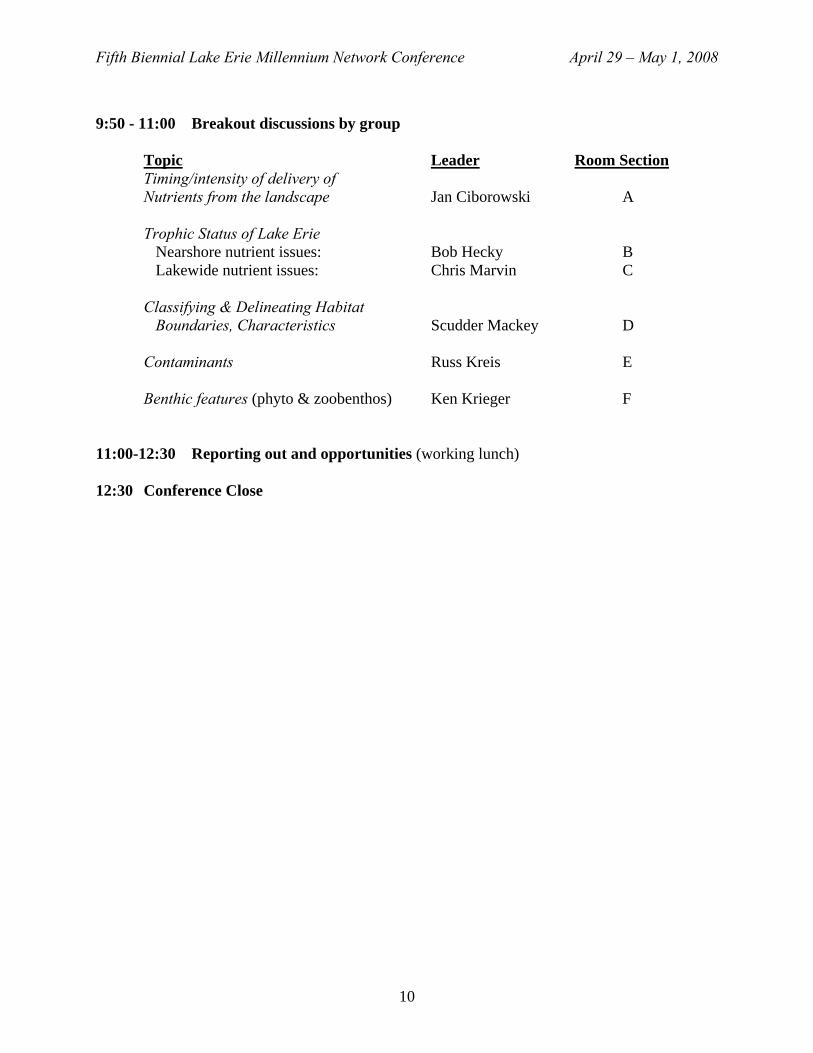
9:50 - 11:00 Breakout discussions by group Topic Leader Room Section Timing/intensity of delivery of Nutrients from the landscape Jan Ciborowski A Trophic Status of Lake Erie Nearshore nutrient issues: Bob Hecky B Lakewide nutrient issues: Chris Marvin C Classifying & Delineating Habitat Boundaries, Characteristics Scudder Mackey D Contaminants Russ Kreis E Benthic features (phyto & zoobenthos) Ken Krieger F 11:00-12:30 Reporting out and opportunities (working lunch) 12:30 Conference Close
10

LAKE ERIE DISSOLVED OXYGEN RECENT CONDITIONS
Paul Bertram1 and J. May2
1. U.S. EPA Great Lakes National Program Office, Chicago, Illinois, USA 2. Contractor to U.S. Public Health Service, Chicago, Illinois, USA
Anoxic hypolimnetic waters in the Central Basin of Lake Erie continue to be observed annually in late summer in at least some locations. For the period 1997-2007, 110 station-years (10 stations X 11 years) of data were screened for the minimum dissolved oxygen concentrations. Anoxic conditions (less than 1 mg/l) were observed 75 times, and hypoxic conditions (12 mg/l) were observed another 22 times. Therefore, oxygen concentrations reached at least an hypoxic state 88% of the time. The total area experiencing anoxia for at least part of the summer season varies annually both in location and extent, with no apparent trend observed. Measured dissolved oxygen concentrations were statistically adjusted to normalize annual differences in hypolimnion thickness and temperature. From 1970 through 1989, the annual normalized rates of oxygen depletion declined. From 1990 through 2007, however, the normalized depletion rates remained nearly steady.
LINKING CLADOPHORA GROWTH TO MUSSEL METABOLISM AND NEARSHORE HYDRODYNAMICS
Harvey A. Bootsma1, Stacey A. Faude1,2, Brian T. Maybruck1, Martin T. Auer3,
and Lisa M. Tomlinson3,4
1. University of Wisconsin-Milwaukee, Great Lakes WATER Institute, 2. Des Moines University
3. Michigan Technological University 4. Arcadis G&M of Michigan
The resurgence of Cladophora in Lake Michigan has coincided with the establishment of
dreissenid mussels in the lake, and it has been hypothesized that mussels have been instrumental in promoting Cladophora growth. We evaluate this hypothesis by using a numerical model to simulate Cladophora growth under pre- and post-mussel conditions. Model simulations suggest that the primary cause of increased algal production is the increase in water clarity resulting from filtration by dreissenids. However, Cladophora are only able to take advantage of increased water clarity because of the supply of dissolved P from mussels. To better understand the relationship between mussels and Cladophora, we have developed a mussel model that simulates P excretion as a function of food supply, mussel population structure, and temperature. Simulations with the linked Cladophora and mussel models indicate that mussel P excretion results in a higher optimal growth temperature for Cladophora. Ultimately, mussel P excretion is limited by food supply, which is driven to a large extent by nearshore-offshore mixing. Better measurements of horizontal mixing are required to assess the impact of mussels on Cladophora growth in the nearshore zone and plankton abundance in offshore waters.

Fifth Biennial Lake Erie Millennium Network Conference April 29 – May 1, 2008
TYPE E BOTULISM: ISSUES & IMPACTS IN MICHIGAN 2006-2007
Mark A. Breederland Michigan Sea Grant Extension, Traverse City, Michigan, USA
Type E botulism mortalities occurred along the shoreline of northern Lake Michigan in 2006 and 2007, impacting a variety of birds including endangered and threatened species such as piping plovers, loons, and fish-eating waterfowl along with some fish including lake sturgeon. This die-off was the first recorded on Lake Michigan since 1983 (pre-Dreissenid). A botulism coordination workshop for Michigan was held in February 2008 with federal, state, local and non-government agency personnel in order to share information, plan for research and coordinate plans in anticipation of an annual summer and fall impact season in 2008 and beyond. Results of this workshop will be shared in order to contribute toward a goal of better Great Lakes basin-wide research, coordination and monitoring of type E botulism impacts.
MICROCYSTIS BLOOMS IN WESTERN LAKE ERIE 2002-2007
Thomas Bridgeman and J. Chaffin Dept. of Environmental Sciences& Lake Erie Center, University of Toledo, Oregon, Ohio, USA Large blooms of the cyanobacteria, Microcystis aeruginosa, have become a re-occurring problem in the Maumee Bay region of western Lake Erie since the mid-1990s. In this study, we used archived zooplankton tows collected in this region from 2002-2007 (n = 343) to quantify annual summer blooms. We developed a density method that permitted relatively rapid separation of Microcystis from other algae and determination of biovolume in the tows. Patterns of bloom development and annual biovolume were then compared to USGS flow data from the Maumee River, which is suspected of playing a role in bloom development by delivering phosphorus and nitrogen to Lake Erie. Highest summer bloom volumes occurred in years with highest summer river flow (2003, 2004), while the lowest Microcystis volume occurred in the driest summer (2002). Winter-spring river discharge was not correlated with summer blooms, suggesting that summer storms and subsequent river discharge may be more important in the development of summer near-shore blooms than annual river discharge.
12
Fifth Biennial Lake Erie Millennium Network Conference April 29 – May 1, 2008
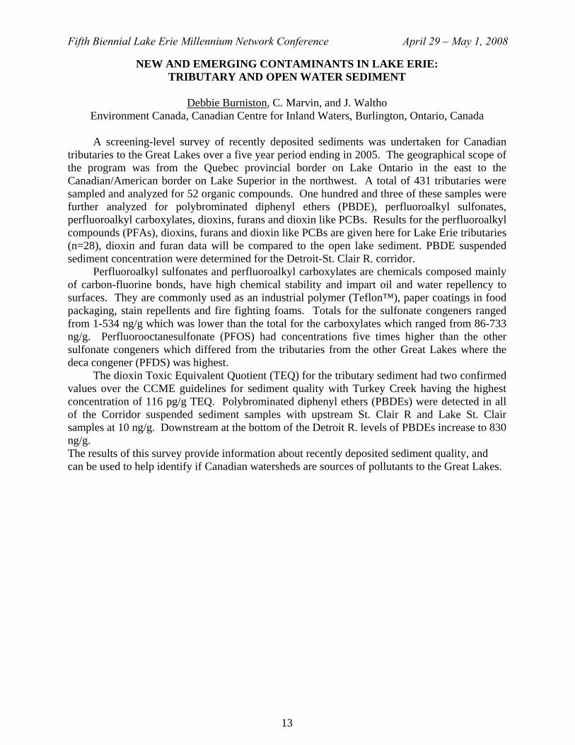
NEW AND EMERGING CONTAMINANTS IN LAKE ERIE: TRIBUTARY AND OPEN WATER SEDIMENT
Debbie Burniston, C. Marvin, and J. Waltho
Environment Canada, Canadian Centre for Inland Waters, Burlington, Ontario, Canada A screening-level survey of recently deposited sediments was undertaken for Canadian tributaries to the Great Lakes over a five year period ending in 2005. The geographical scope of the program was from the Quebec provincial border on Lake Ontario in the east to the Canadian/American border on Lake Superior in the northwest. A total of 431 tributaries were sampled and analyzed for 52 organic compounds. One hundred and three of these samples were further analyzed for polybrominated diphenyl ethers (PBDE), perfluoroalkyl sulfonates, perfluoroalkyl carboxylates, dioxins, furans and dioxin like PCBs. Results for the perfluoroalkyl compounds (PFAs), dioxins, furans and dioxin like PCBs are given here for Lake Erie tributaries (n=28), dioxin and furan data will be compared to the open lake sediment. PBDE suspended sediment concentration were determined for the Detroit-St. Clair R. corridor. Perfluoroalkyl sulfonates and perfluoroalkyl carboxylates are chemicals composed mainly of carbon-fluorine bonds, have high chemical stability and impart oil and water repellency to surfaces. They are commonly used as an industrial polymer (Teflon™), paper coatings in food packaging, stain repellents and fire fighting foams. Totals for the sulfonate congeners ranged from 1-534 ng/g which was lower than the total for the carboxylates which ranged from 86-733 ng/g. Perfluorooctanesulfonate (PFOS) had concentrations five times higher than the other sulfonate congeners which differed from the tributaries from the other Great Lakes where the deca congener (PFDS) was highest. The dioxin Toxic Equivalent Quotient (TEQ) for the tributary sediment had two confirmed values over the CCME guidelines for sediment quality with Turkey Creek having the highest concentration of 116 pg/g TEQ. Polybrominated diphenyl ethers (PBDEs) were detected in all of the Corridor suspended sediment samples with upstream St. Clair R and Lake St. Clair samples at 10 ng/g. Downstream at the bottom of the Detroit R. levels of PBDEs increase to 830 ng/g. The results of this survey provide information about recently deposited sediment quality, and can be used to help identify if Canadian watersheds are sources of pollutants to the Great Lakes.
13

Fifth Biennial Lake Erie Millennium Network Conference April 29 – May 1, 2008
STATUS OF NUTRIENTS IN LAKE ERIE
Murray N. Charlton
There is evidence of offshore and near shore algal problems. These are related to elevated nutrient concentrations, mainly phosphorus. Some agricultural rivers have very high P concentrations while some loads are very low and un-damaging concentrations. A list of mitigation measures will be discussed.
WATER QUALITY OF ONTARIO AGRICULTURAL STREAMS: DEFINING NUTRIENT CONCENTRATIONS TO PREVENT EUTROPHICATION
Patricia A. Chambers1, C. Vis1, R.B. Brua2, M. Guy1, J.M. Culp3, and G. Benoy4 1. Environment Canada, 867 Lakeshore Rd., Burlington, ON, L7R 4A6 Canada 2. Environment Canada, 11 Innovation Blvd., Saskatoon, SK, S7N 3H5 Canada
3. University of New Brunswick, Department of Biology, Fredericton, NB, E3B 5A3 Canada 4. Agriculture & Agri-Food Canada, 850 Lincoln Rd., Fredericton, NB, E3B 4Z7 Canada
Inputs of nutrients (phosphorus, P, and nitrogen, N) to fresh waters can cause excessive aquatic plant growth, depletion of oxygen, and deleterious changes in abundance and diversity of aquatic invertebrates and fish. As part of a “National Agri-Environmental Standards Initiative”, the Government of Canada committed to development of non-regulatory environmental performance standards that establish nutrient concentrations to protect ecological condition of agricultural streams. Analysis of data from long-term provincial monitoring programs and experimental studies in networks of 10-15 streams showed that agricultural land use increased nutrient concentrations in southern Ontario streams, resulting in increased sestonic and benthic algal abundance, loss of sensitive benthic macroinvertebrate taxa, and an increase in benthic diatom taxa indicative of eutrophication. Calculation of provisional standards for total P or total N using three empirical methods followed by cross-calibration of these chemical standards with information on biological condition resulted in recommendations for total P and total N standards for agricultural streams in southern Ontario. These recommended standards should result in good ecological condition with respect to benthic algal abundance, benthic diatom composition and benthic macroinvertebrate composition. Research is continuing to determine whether these standards are protective of downstream receiving waters and to evaluate interactions of nutrients with other stressors (e.g., suspended sediments, pesticides), specifically their combined effects on aquatic food webs.
14

Fifth Biennial Lake Erie Millennium Network Conference April 29 – May 1, 2008
FISH ASSEMBLAGES IN NEARSHORE BEACHES OF THE HURON-ERIE CORRIDOR AND THE NORTH SHORE OF LAKE ERIE
Lynda D. Corkum1, S.N. Dopazo1, N.E. Mandrak2, S.M. Reid2
1. Department of Biological Sciences, University of Windsor, Windsor, Ontario, Canada 2. Great Lakes Laboratory for Fisheries and Aquatic Sciences, Fisheries and Oceans
Canada, Burlington, Ontario, Canada In two independent, but complementary studies, we investigated fish-habitat associations in Canadian waters, extending from the southern end of the St. Clair River to the eastern end of Lake Erie. We measured a suite of environmental variables and used 3 to 5 seine hauls per site to sample fishes. Thirty sites were sampled in the day and a subset (n=14) at night from the St, Clair River to central Lake Erie in summer (2006) and 24 sites (day/night samples) in the spring and fall along the entire north shore of Lake Erie (2005 and 2006). Dominant fishes were the benthic round goby and pelagic schooling fishes (emerald shiner, spottail shiner, mimic shiner, brook silverside, white perch), as well as insectivorous and planktivorous fishes. Rarefaction analysis showed that overall species richness was greater in the day than night for the western sites, but greater in the night than day for the Lake Erie beaches. Nevertheless, round goby abundance was significantly greater at night than day. Round gobies were positively associated with water temperatures up to 24°C, but there was no relationship between round goby abundance and warmer temperatures. Season had a larger and more consistent effect on beach fish assemblages than diel period. One third of fishes known from the Lake Erie basin were captured at nearshore beaches, indicating the importance of this habitat. Future studies should examine the loss and modification of shoreline protection structures on fish assemblages in beach habitats.
15
Fifth Biennial Lake Erie Millennium Network Conference April 29 – May 1, 2008
ECOFORE: A RESEARCH PROGRAM TO SYNTHESIZE LAKE ERIE DATA AND TO DEVELOP A HYPOXIA FORECASTING MODELING FRAMEWORK
Joseph V. DePinto1, Don Scavia2, David Allan2, Tomas Hook3
1. LimnoTech, Ann Arbor, Michigan, USA 2. School of Natural Resources and Environment, University of Michigan, Ann Arbor, MI 3. Cooperative Institute for Limnological and Ecological Research, NOAA-GLERL and
University of Michigan, Ann Arbor, MI In the past several years, considerable field observation and process research has been conducted on Lake Erie to try to understand the apparent re-occurrence of significant hypoxia events in the central basin of the lake. Even more recently, significant nearshore nuisance attached algal growth has begun to plague the lake again. A team of researchers, funded by a NOAA-CSCOR Ecosystem Forecasting grant, is about one year into a five year research program with the overall goal to create, test, and apply models to forecast how anthropogenic (land use, invasive species) and natural (climatic variability) stresses influence hypoxia formation in Lake Erie and it ecological impacts, with an emphasis on fish production potential. The project has three components: 1) forecasting changes in nutrient loads (watershed modeling), forecasting responses of central basin hypoxia to those changes (Lake Erie water quality modeling), and forecasting potential ecological responses to changes in hypoxia (fish bioenergetics and production modeling). All three components will use multiple models and generate ensemble forecasts that explicitly recognize the range of uncertainties in model drivers and models. In addition, assessment of the variations in model output will help identify key uncertainties in the forecasted scenarios. These forecasts will be conducted within an Integrated Assessment framework that provides legitimate, useful, and timely information and advice over time and space scales relevant for land-use, water quality, and fisheries management. This talk will present an overview of this modeling research project and accomplishments during the first year.
16

Fifth Biennial Lake Erie Millennium Network Conference April 29 – May 1, 2008
VULNERABILITY OF LOWER GREAT LAKES COASTAL WETLAND COMMUNITIES TO CLIMATE CHANGE
Susan E. Doka, L.D. Mortsch, J. Ingram, and A.J. Hebb
Fisheries and Oceans Canada, Environment Canada, and University of Waterloo The objectives of this project were two-fold. One, to predict the biotic response of fish guilds to wetland habitat changes that result from anticipated water levels and temperatures after 50 years of climate change. Two, to assess the sensitivity of fish species to projected coastal changes. We assessed probable changes in fish habitat availability and suitability, including changes in wetland vegetation, for nearshore fish assemblages under different climate change scenarios. A fish habitat supply analysis for different thermal guilds was conducted that suggested different guilds may be limited in the future. In addition, the vulnerability of current fish assemblages in coastal wetlands was assessed. Results indicated that site-specific responses can vary but productive coastal habitats will decrease under possible very low water level conditions. Proactive adaptation strategies will be discussed in light of projected nearshore changes and vulnerabilities of species.
ORGANIC CONTAMINANTS IN LAKE ERIE OFFSHORE WATERS
Alice Dove Environment Canada, Burlington, Ontario, Canada
As part of its Great Lakes Surveillance Program, Environment Canada conducts water quality monitoring in Lake Erie. The Surveillance Program produces long-term trend information for the measured parameters as well as information about their spatial distributions, within each lake and across the Great Lakes basin as a whole. Since 1986, the Surveillance Program has included organic contaminants in its analytical suite. This is a relatively difficult task since concentrations can be very low. In 2004, new field and analytical methodologies were introduced to help improve results. In this presentation, the most recent organic contaminants data will be presented for Lake Erie.
17
Fifth Biennial Lake Erie Millennium Network Conference April 29 – May 1, 2008
RECENT TRENDS IN PCBS IN WESTERN LAKE ERIE FISH AND WILDLIFE
Ken G. Drouillard Great Lakes Institute for Environmental Research, University of Windsor,
Windsor, Ontario, Canada
Fish advisories are issued to warn the public, and sensitive human sub-groups, about health issues related to the consumption of contaminated fish flesh. The presence of fish advisories in Lake Erie and its connecting channels has also been used as a regulatory tool and surrogate measurement for evaluating improvements in ecosystem contamination. Yet, despite noted improvements in sediment chemistry for many legacy contaminants such as PCBs and mercury, the number of fish advisories issued within Lake Erie has increased through time. This apparent contradiction results from several complicating factors including: 1) regulatory bodies have decreased the minimum concentrations that trigger the issuing of fish consumption advisories and expanded the number of contaminants which are considered for issuing of fish advisories; 2) physical, chemical and ecological conditions within Lake Erie have changed and have potentially altered chemical exposure dynamics in aquatic food webs and 3) monitoring programs designed to develop fish consumption advisories are not necessarily the best types of programs needed to evaluate ecosystem improvements in contamination. In this talk, I will examine available data sets documenting contaminant trends in sport fish and wildlife and focus on temporal trends determined in indicator species over the past decade. Models and available experiments that address the bioaccumulation implications of multiple stressors (species invasions, habitat alterations and climate change) in monitored fish and wildlife species will be considered as alternative explanations for increasing trends in fish advisories issued in this system.
18

Fifth Biennial Lake Erie Millennium Network Conference April 29 – May 1, 2008
THE DEVELOPMENT OF THE ENVIRONMENTAL INDICATORS FOR NITROGEN (RESIDUAL SOIL NITROGEN AND THE INDICATOR OF RISK OF WATER
CONTAMINATION OF NITRATE-N) AND MANAGEMENT PRACTICES WHICH REDUCE NITRATE LOSS
Craig F. Drury1, Jingyi .Y. Yang1, Reinder De Jong2, Xueming M. Yang1, E. (Ted) C. Huffman2
and Keith Reid3
1. Agriculture & Agri-Food Canada, Harrow, Ontario, Canada 2. Agriculture & Agri-Food Canada, Ottawa, Ontario, Canada
3. Ontario Ministry of Agriculture Food and Rural Affairs, Stratford, Ontario, Canada
Nitrate leached from agricultural soils can be both an environmental concern when it enters rivers and lakes, and a human health concern when it enters aquifers used for potable water. Residual soil nitrogen (RSN) is the amount of inorganic nitrogen that remains in the soil at the end of the growing season after crops have been harvested. RSN can be estimated as the difference between all N inputs (fertilizer, manure-N, biological fixation, and atmospheric deposition) and all N outputs (N removed in crop harvest, N lost from ammonia volatilization and N lost from denitrification). RSN was calculated on a regional scale as well as on a provincial and national level from 1981 to 2006. The Canadian average RSN values steadily increased steadily from 9.3 to 15.5 kg N/ha (67 % increase) from 1981 until 1996 and then to 25.0 kg N/ha (61% increase) by 2001. The RSN values decreased to 17.7 kg N/ha in 2006. The spike in RSN values in 2001 was due to a combination of factors including low crop yields as a result of drought conditions in many parts of Canada in the summer of 2001 as well as an increase in legume crop acreages which contributed to large N inputs (fixation of atmospheric N) without a corresponding decrease in either fertilizer or manure inputs. In Ontario, the RSN estimate was greater than all other provinces in 1981 at 42.2 kg N/ha which was over 4 times the Canadian average (9.3 kg N/ha). These levels were high as a result of the increased amount of N added to Ontario soils through fertilizer, manure and nitrogen fixation in the highly productive regions in Eastern Canada. RSN levels remained fairly steady over the 6 census years except for 2001 when the RSN level reached 59.9 kg N/ha due to low N uptake under drought conditions and an increase in legume acreage. The amount and concentration of N lost through leaching (IROWC-N) after harvest is dependent upon the RSN levels and the water budget (antecedent soil moisture content, precipitation, evaporation and surface runoff). In Ontario, the amount of N lost remained fairly constant with a range of 14.4 kg N/ha in 1981 to 17.6 kg N/ha in 1991, while N concentration in the drainage water ranged from 8.4 mg N/L in 1981 to 9.6 mg N/L in 2001. Management practices such as cover crops and controlled tile drainage – subirrigation (CDS) have been identified as possible ways to reduce nitrate losses.
19
Fifth Biennial Lake Erie Millennium Network Conference April 29 – May 1, 2008
THE GREAT LAKES INSTITUTE FOR ENVIRONMENTAL RESEARCH (GLIER): FOCUSED ON ENVIRONMENTAL TRACERS
Brian J. Fryer
Director, Great Lakes Institute for Environmental Research, Windsor, Ontario, Canada
GLIER is a multidisciplinary research institute housed in a 5200 square-metre, tri-level facility on the Detroit River. It includes over 25 extensively equipped laboratories, offices for researchers, post-doctoral fellows and graduate students, and conference and meeting rooms. GLIER maintains a private boat launch on the Detroit River and has dedicated research vessels, the largest of which is docked at Colchester, Lake Erie.
The physical infrastructure of GLIER is focused around open access multi-user central research facilities. The backbone of the chemistry laboratories are CAEAL certified organic and metal contaminant analytical capabilities that are complimented by research laboratories conducting both analytical development and aquatic environmental applications in organic, metal and isotope (C, N, Fe, Sr) chemistry including in-situ microanalysis (LA-(MC)ICP-MS and ESEM). Combined with our extensive environmental genomics capabilities the GLIER facilities allow for comprehensive studies on the impact of multiple stressors on large aquatic ecosystems. GLIER also hosts CAISIN, the Canadian Aquatic Invasive Species Network.
Current and future GLIER research programs on the Lake Erie ecosystem are focused on invasive species (e.g. MacIsaac-CAISIN), Lake Erie food webs (e.g. Haffner, Fisk, Drouillard and partners) and fish population dynamics (e.g. role of river plumes in percid recruitment, Fryer and Heath from GLIER, NOAA GLERL, OSU, Ontario and State agencies). Research activities are typically collaborative and training opportunities focus on multidisciplinary approaches.
20
Fifth Biennial Lake Erie Millennium Network Conference April 29 – May 1, 2008
WINDSOR-ESSEX ENVIRONMENTAL METADATA SYSTEM (WEEMS): A LOCAL APPROACH TO MAKING RESEARCH BASED DATA AND METADATA
AVAILABLE FOR COLLABORATION
Alice Grgicak-Mannion1, P. Grzeszczak1, J. Ciborowski2
1. Department of Earth and Environmental Sciences, University of Windsor, Windsor, Ontario, Canada
2. Department of Biological Sciences, University of Windsor, Windsor, Ontario, Canada
Over the past three years, the University of Windsor’s Geographic Information Systems (GIS) and Biological Sciences teams have partnered with the Ontario Ministry of the Environment’s Canada–Ontario Agreement (COA) group to develop an online repository of local geospatial and biological metadata which was named the Windsor–Essex Environmental Metadata System (WEEMS). This tool fulfilled the main objectives of Annex IV of the COA, which were to establish systems that incorporate specific vocabularies, standards and protocols designed to track environmental change and progress in the Great Lakes Basin. WEEMS’ key objectives were to be: (a) accessible to the public via the internet, (b) compatible with other information management systems and (c) facilitate interoperability and data portability. We propose taking these key objectives to the next level by encouraging development of other local systems (nodes) situated around the Great Lakes Basin. Ultimately, this would result in the self-assembled formation of a research based network that would provide researchers remote access capabilities to other data catalogs and datasets, thus promoting collaboration amongst peers.
SEDIMENT TRANSPORT OBSERVATIONS IN LAKE ERIE
Nathan Hawley Great Lakes Environmental Research Laboratory, Ann Arbor, Michigan, USA
Time series observations of water temperature, turbidity, current velocity, and wave action were made in the central (max depth 25 m) and eastern (max depth 55 m) basins of Lake Erie from September 2004 through October 2005. During the fall and early winter (Oct-Jan) increased turbidity in the central basin is correlated with wave and current activity, so most of the increases were due to local resuspension of bottom material. There is no evidence that resuspension occurred in the eastern basin. Instead, increased turbidity appears to be due primarily to advection of material resuspended elsewhere. Wave action stopped after the lake became covered by ice in early February and did not occur again until the ice melted in April. No sediment resuspension, and little advection of suspended material, was recorded while ice covered the lake. After the ice melted, smaller resuspension events were observed in the central basin until the water became stratified in mid June. After that time, no resuspension was observed until the lake re-mixed in late September.
21

Fifth Biennial Lake Erie Millennium Network Conference April 29 – May 1, 2008
CAN DREISSENID MUSSELS EUTROPHY THE COASTAL ZONES OF THE GREAT LAKES?
Bob Hecky
Department of Biology, University of Minnesota, Duluth, Minnesota, USA
Cladophora glomerata and cyanobacterial blooms were the highly visible signs of eutrophication of the lower Great Lakes in the 1960's and 70's. Algal beach fouling complaints and observations of blooms declined with the imposition of the Great Lakes Water Quality Agreement and imposition of P management at point sources and in detergents across the lakes. Recent resurgence of Cladophora and Microcystis blooms have renewed concerns that coastal areas may again be suffering increased P inputs related to urban growth and intensifying agricultural land use. Direct evidence of either higher loading of P from catchment streams or increased P in coastal areas is lacking in at least some areas suffering increasing algal bloom complaints. Also during the Cladophora growth season coastal P concentrations are not demonstrably higher than offshore concentrations and are certainly lower than in the bad old days. However, dreissenids represent a new benthic littoral source of dissolved P from their consumption of pelagic phytoplankton and particulate matter and subsequent excretion and defecation. This new source of recycled P concentrated in the coastal areas is most likely responsible for the resurgence of nuisance algal growths along many coastlines, both urban and rural, in the lower lakes.
THE PRESENCE OF PHARMACEUTICALS, PERSONAL CARE PRODUCTS, AND OTHER CONTAMINANTS IN SOURCE WATER
Dr. Saad Jasim
CEO, Walkerton Clean Water Centre, Walkerton, Ontario, Canada Reports by different scientific groups indicate concern about traces of drugs that could make their way into tap water. Studies indicate that activated carbon and ozone are promising treatment methods to remove traces of pharmaceuticals and pesticides. Studies were conducted to evaluate the occurrence of pharmaceuticals and endocrine disrupting chemicals in source water supply, and the effectiveness of ozone in removing these compounds. The analysis indicated that trace levels of compounds such as carbamazepine, caffeine, cotinine, and atrazine were detected in raw water and that treatment with ozone resulted in a greater removal versus conventional treatment. Antibiotic resistance is the issue receiving the most attention of all the PPCPs, especially since a large portion of antibiotics leave the body and end up in receiving waters. EDCs may cause adverse effects including hormone dependent cancers, reproductive tract disorders, and reduction in reproductive fitness. Effects on wildlife have been documented from PPCPs in surface waters. Studies in the United Kingdom and United States in the 1990s indicated reproductive abnormalities in fish living below wastewater treatment plants.
22
Fifth Biennial Lake Erie Millennium Network Conference April 29 – May 1, 2008
MULTIVARIATE SUMMARIES OF GREAT LAKE STRESSOR LOADINGS USING WATERSHED DELINEATIONS AT MULTIPLE SCALES
L. Johnson1, Tom Hollenhorst1, G. Host1, J. Ciborowski2, G. Niemi1, and N. Danz1
1. Natural Resources Research Institute, University of Minnesota Duluth, Duluth, MN, USA 2. Department of Biological Sciences, University of Windsor, Windsor, ON, Canada
We have used watershed delineations at a variety of scales as summary units for
quantifying anthropogenic stress existing in the Great Lakes. We have also developed two approaches for integrating the many different variables representing different types of anthropogenic stress found throughout the Great Lakes basin. More recently, we have developed a multi-scale watershed model in which the contributions from specific sub-catchment, watersheds can be summed as one progresses from point to point down the hydrologic networks. This allows one to customize the scale of existing stressor summaries for specific portions of the Great Lakes Coastline, rivers and estuaries. Understanding these stressor loadings at multiple scales allows us to identify benchmarks of reference and degraded condition specific to lakes, individual states or ecoregions. These stressor summaries also provide a framework for developing sampling designs for deriving and validating indicators of ecological condition for Great Lakes coastal ecosystems.
23

Fifth Biennial Lake Erie Millennium Network Conference April 29 – May 1, 2008
AN INTEGRATED HABITAT CLASSIFICATION AND MAP OF THE LAKE ERIE BASIN
L. B. Johnson1, Scudder D. Mackey2, T. Hollenhorst1, J.J.H. Ciborowski2, D.T. Button3,
and R. Gauthier4
1. Natural Resources Research Institute, University of Minnesota Duluth, Duluth, MN, USA 2. Department of Biological Sciences, University of Windsor, Windsor, ON, Canada
3. US Geological Survey, Columbus, OH, USA 4. Great Lakes Commission, Ann Arbor, MI, USA
The Lake Erie Binational Habitat Classification project was designed to provide a
framework for mapping and tracking changes in the condition of Lake Erie’s natural and developed lands. This is an essential element of the Lake Erie LAMP’s habitat vision. ‘Dynamic habitat’ is defined as an area in which an essential suite of environmental and biological conditions overlap to produce conditions suitable for an organism or community of interest. Physical, chemical, and biological environmental characteristics are integrated and classified using statistical and/or geospatial analyses to generate dynamic habitat maps (or polygons) as a function of the species, community, or ecological function of interest.
Six natural habitat zones were classified and delineated at common scales across the entire Lake Erie basin: 1) terrestrial, 2) inland aquatic, 3) coastal wetland, 4) coastal margin, 5) nearshore open-water, and 6) offshore open-water. To examine scale-dependencies and to integrate diverse classification methods, common high resolution classification and mapping was performed for the Grand River, ON and the Maumee River, OH. The classification systems used for each habitat zone were derived from existing templates, modified to permit evaluation across the entire Lake Erie basin. These classification systems form the framework for the Lake Erie LAMP’s ecosystem indicator system (presently under development). A suite of 12 ‘master variables’ that pertain across all 6 habitat zones has been mapped for the entire Lake Erie basin (http://www.glc.org/erhabitat/catalog.html). Ongoing work continues to refine the spatial resolution of these variables. A common set of geospatial tools can be applied to these variables to document ecosystem changes in the basin.
24

Fifth Biennial Lake Erie Millennium Network Conference April 29 – May 1, 2008
AGRI-ENVIRONMENTAL RESEARCH AND PROGRAMS LINKING THE LAND TO THE LAKE
Pamela Joosse
Great Lakes Environmental Management Branch, Ontario Ministry of Agriculture, Food and Rural Affairs, Guelph, Ontario, Canada
The Ontario Ministry of Agriculture, Food and Rural Affairs has a long history of funding
nutrient management and other agri-environmental research and programs in the province. Evolving provincial priorities and regulations have spurred further investigations and activities. This presentation will highlight various agri-environmental research and stewardship programs and point to where future opportunities for linking the land to the lake may lie.
CORRELATIONS BETWEEN SOLUBLE REACTIVE PHOSPHORUS (SRP) LOADING AND PHYTOPLANKTON BIOMASS IN THE WESTERN BASIN OF LAKE
ERIE
Douglas D. Kane1, J. D. Conroy1, D.A. Culver2, R.P. Richards2, D. B. Baker3 1. Defiance College, Definace, Ohio, USA
2. The Ohio State University, Columbus, Ohio, USA 3. Heidelberg College, Tiffin, Ohio, USA
Many hypotheses have been advanced to explain recurrent algal blooms in the western basin of Lake Erie, including abiotic (e.g., total phosphorus load) and biotic (e.g., dreissenid mussel excretion) explanations. We used two long-term (10 + year) datasets to test whether total phytoplankton biomass and cyanobacterial biomass correlated with soluble reactive phosphorus (SRP) loading from agriculturally-influenced tributaries (Maumee and Sandusky rivers) to the western basin of Lake Erie. We constructed linear regression models to determine if total phytoplankton biomass (and cyanobacterial biomass, individually) increased with recent SRP-load increases. Both total phytoplankton and cyanobacterial seasonal (May-October) average (arithmetic mean) wet-weight biomasses significantly increased with increased water-year total SRP load for the Maumee River (both total phytoplankton and cyanobacteria biomass vs. SRP load) and the sum of SRP load for the Maumee and Sandusky rivers (total phytoplankton biomass vs. SRP load; cyanobacteria biomass vs. SRP load), but not for the Sandusky River. However, when using seasonal median total phytoplankton and cyanobacterial biomasses as response variables to remove the influence of bloom events and the Beale Ratio Estimator to account for missing SRP data, only the relationship between median cyanobacterial biomass and Beale-ratio estimated SRP load were significant. In conclusion, recent increased western basin tributary SRP loads likely contribute to increases in phytoplankton biomass and more frequent algal blooms, especially cyanobacteria, in the western basin of Lake Erie.
25

Fifth Biennial Lake Erie Millennium Network Conference April 29 – May 1, 2008
GREAT LAKES CENTER AT BUFFALO STATE COLLEGE: MISSION, PERFORMANCE, FACILITIES
Alexander Karatayev, C. Basiliko, L. Burlakova, M. Clapsadl, S. Christopher, S. Kumar, J.
Mukherjee, C. Pennuto, and A. Perez-Fuentatja Great Lakes Center, Buffalo State College, Buffalo, USA
E-mail: [email protected]
The Great Lakes Center is a multidisciplinary research, education, and service institute with a primary focus on the Great Lakes. The Center is committed to providing the best possible science for understanding the physical, chemical, biological, and social dimensions of the Great Lakes and their watersheds. Research expertise within the Center includes: fisheries, plankton, and benthic ecology; understanding the effects of invasive species in aquatic systems; understanding land-use impacts on surface water quality; the transformation, movement, and health effects of environmental contaminants, and lake and watershed carbon and nitrogen dynamics.
The Great Lakes Center mission is to improve the quality of the environment by providing the best possible science to decision-makers concerned with the health and sustainability of resources, with a primary focus within the Great Lakes and their watersheds. This is accomplished through high quality research, informed and current graduate and undergraduate education, and dissemination of information to the public through outreach. The Center is committed to improving human-environment interactions in the Great Lakes ecosystem guided, in part, by an understanding of the evolutionary and ecological processes and patterns acting on the system. Center personnel are engaged in scholarly research activities promoting greater understanding of the biological, chemical, and physical dynamics of the environment, but especially concerning processes, contaminants, and structure of the Great Lakes and their watersheds. Over the last four years, the Center: published 56 papers, presented 55 conference talks, submitted 93 grants, received a total of $3,328,732 in funding.
Great Lakes Center facilities include state-of-the-art laboratories at its Field Station on Lake Erie, a fleet of research vessels capable of operating in the open Great Lakes (40-foot Aquarius, and the 26-foot Seneca) and their contributing waters, a demonstration watershed for research and teaching, an Environmental Toxicology Laboratory on the Buffalo State College campus, and a variety of sampling and analytical equipment to support the research and educational missions.
26

Fifth Biennial Lake Erie Millennium Network Conference April 29 – May 1, 2008
FINDING SIGNALS OF THE LANDSCAPE IN COASTAL ENVIRONMENTS
Jack Kelly, P. Yurista, J. Morrice, and G. Peterson Mid-Continent Ecology Division, Office of Research and Development, U.S. EPA, Duluth MN Our studies in the past ~7 years have explored connections between coastal watersheds and coastal aquatic ecosystems across the Great Lakes. Landscape disturbance gradients identified by the Great Lakes Environmental Indicators (GLEI) Project (Danz et al. 2007, Niemi and Kelly, 2007) have provided a basis for experimental study designs to identify signals of landscape loading and coastal responses. We have demonstrated that water quality traces of the landscape character are detectable in coastal tributaries, coastal wetlands, semi-enclosed embayments, and even out into the open nearshore. One finding is that landscape signals are diluted across a hydrological continuum from ecosystems that are more firmly embedded in the landscape (tributaries and some coastal wetlands) to those that are more at the receiving edge of the watershed and strongly influenced by various lake processes (other coastal wetlands, embayments, and the nearshore). Recognizing the faint landscape signal and a generally high variability in the open nearshore, we have employed powerful high-resolution, continuous sampling technology successfully to identify landscape-nearshore connections in water quality and plankton responses. This presentation provides several examples highlighting landscape reflections observed within different coastal ecosystems. This abstract does not necessarily reflect EPA policy. Danz, N., G.J. Niemi, R.R. Regal, T. Hollenhorst, L. Johnson, J. Hanowski, R.P. Axler, J.
Ciborowski, T. Hrabik, V.J. Brady, J.R. Kelly, J.A. Morrice, J.C. Brazner, R. Howe, C.A. Johnson, and G.E. Host. 2007. Integrated measures of anthropogenic stress in the U.S. Great Lakes Basin. Environmental Management 39:631-647.
Niemi, G. J. and J.R. Kelly (Eds.). 2007. Coastal Indicators. Journal of Great Lakes Research 33 (Special Issue 3).
27
Fifth Biennial Lake Erie Millennium Network Conference April 29 – May 1, 2008
BAITFISH AND VHS IN ONTARIO
Brenda Koenig1, C. Brousseau1, S. Kerr1, and E. Wright2 1. Fisheries Section, Ontario Ministry of Natural Resources, Peterborough, ON, Canada 2. Fish Health and Aquaculture, Ontario Ministry of Natural Resources, Peterborough,
ON,Canada
Viral hemorrhagic septicemia (VHS) was first identified in Ontario during 2005 after a die-off of fish in the Bay of Quinte, Lake Ontario. The virus has now been found in more than 25 species of fish in the Great Lakes, including walleye, yellow perch, small-mouth and large-mouth bass, muskellunge and several species of baitfish. In January 2007, interim measures to control the harvest and transport of live baitfish were invoked. This involved the designation of management zones across the province; an infected zone, a buffer zone and a virus-free zone. Baitfish harvest from an area encompassing the lower Great Lakes was prohibited. These measures were designed to slow the spread of VHS from the Great Lakes to inland waters and had significant impacts on baitfish harvesters within the VHS infected and buffer zones. Following this, the Ontario Ministry of Natural Resources (OMNR) met with several stakeholders to share information and gather feedback on potential management approaches for the future. A revised one-year interim management strategy was announced in March 2007 and included a broader definition of virus-positive waters and a VHS Management Zone, The operation of fishways and existing manual transfers of fish over barriers did not change, however restrictions were placed on the use of fish, eggs and spawn collected from the VHS Management Zone. The new strategy allowed baitfish harvesters and dealers in the VHS Management Zone to resume limited operation but restricted movement of live baitfish out of the zone, helping to slow the spread of the virus. Challenges existed because other movements of fish such as anglers moving baitfish were not restricted. The OMNR initiated an education and awareness campaign to share information about the VHS virus and potential impacts on fish and preventative actions that the public and stakeholders could take to help slow the spread. This initiative included the development of fact sheets, a website, and slide presentations. Another aspect of the management response included monitoring through the collection of fish for VHS testing in the spring and fall of 2007.
28
Fifth Biennial Lake Erie Millennium Network Conference April 29 – May 1, 2008
THE BENTHOS OF LAKE ERIE: CURRENT RESEARCH DIRECTIONS AND RESEARCH NEEDS
Kenneth A. Krieger
National Center for Water Quality Research, Heidelberg College, Tiffin, Ohio, USA
The zoobenthos of all three basins of Lake Erie continues to be dominated numerically by an oligochaete community generally reflective of enriched conditions, while burrowing mayflies (Hexagenia) are restricted mostly to the western basin. Dreissenid (zebra and quagga) mussels appear to be declining in abundance in many areas of the lake, and zebra mussels have largely been replaced by quagga mussels. Several themes dominate current benthological research in Lake Erie: (1) Role of physical processes and trophic dynamics, including sediment oxygen demand (SOD), on the development, severity, and extent of hypoxia in the central basin, its concomitant effects on fish and invertebrate ecology (e.g., availability of benthic prey) and life histories, and conversely, the impact of the zoobenthos on SOD and dissolved oxygen at the sediment-water interface. (2) Interactions between species of Hexagenia (burrowing mayflies) and Dreissena (zebra and quagga mussels), and the importance of shifts in distributions and abundances of individual species. (3) Population dynamics and ecosystem impacts of keystone and invasive species (e.g., Hexagenia, Dreissena, Lyngbya), including life histories, population regulatory mechanisms, and their roles as nutrient sinks and shunts. (4) Zoobenthic species distributions and biomass as indicators of trophic status. More research should be devoted to (1) physical, chemical and biological linkages of offshore and nearshore processes, e.g., the extent and impact of offshore transport of nutrients, algae, and sediments; (2) sublethal impacts of phytotoxins and persistent toxic organics in sediments on the zoobenthos and higher trophic levels; (3) factors determining the success and ecosystem impacts of new invasive zoobenthic and phytobenthic species.
29
Fifth Biennial Lake Erie Millennium Network Conference April 29 – May 1, 2008
PHYSICAL CHANGES IN NEARSHORE HABITAT
Scudder D. Mackey Department of Biological Sciences, University of Windsor, Windsor, ON
Nearshore aquatic habitat requirements vary and depend on the species and life stage of the biological community under consideration. These communities have adapted to a range of habitat conditions that are controlled, in part, by physical processes acting in the nearshore. In Lake Erie, anthropogenic activities have altered coastal processes causing the Lake to pass through several major habitat “tipping “points many decades ago. Present-day management strategies are now attempting to manage remaining nearshore habitats in what are severely altered and degraded coastal systems.
Anthropogenic alterations to river mouths and the “armoring” of shorelines modify flow paths and disrupt nearshore coastal processes that create and maintain coastal margin and nearshore habitats. Reductions in the volume of available littoral sand has lead to the “coarsening” of nearshore substrates and the gradual replacement of mobile sand sheets with stable heterogeneous lag deposits resting on bedrock or cohesive clay substrates. Recent sidescan sonar and underwater video data demonstrate that the loss of protective sand sheets has significantly altered the pattern and distribution of nearshore aquatic habitats and formed an armored pavement on the lakebed. These lag deposits create ideal conditions for colonization by Dreissenids, round gobies, and other non-native species that use coarse-grained substrates as habitat. Interestingly, underwater video data reveals that cohesive clays are not colonized by either Dreissenids or Cladophora.
Irrespective of cause, anticipated lower Lake water levels over the long term may affect nearshore coastal processes, nearshore sediment dynamics, and alter hydraulic connectivity between coastal margin systems and open-Lake environments. Tributary flow regimes may also be altered resulting in changed nutrient and sediment loads into nearshore waters. Continued coastal development, claiming of submerged lands, and subsequent armoring of these submerged lands do not bode well for natural ecosystem adjustments in response to long-term changes in Lake Erie water levels.
30
Fifth Biennial Lake Erie Millennium Network Conference April 29 – May 1, 2008
NUTRIENT CHEMISTRY OF STREAMS AND BIOTA OF NEARSHORE REGIONS IMPROVE WITH IMPLEMENTATION ON TOTAL FARM PLANNING IN
THE FINGER LAKE OF NEW YORK
J.C. Makarewicz and T. Lewis Department of Environmental Science and Biology, State University of New York at Brockport,
Brockport, NY, USA
Research in the Finger Lakes has demonstrated that loss of nutrients and soils from some watersheds in agriculture are comparatively high relative to other areas with less agriculture in their watersheds. We tested the hypothesis that Management Practices, specifically targeted to reduce nutrient and soil loss, implemented in an experimental watershed would lead to reductions in nutrient chemistry in streams and improvement in metaphyton, macrophytes and bacteria in the nearshore of a lake. Several general management practices were implemented beginning in 2003 and continue to date based on the total farm planning approach. Management practices included reduction of fertilizer (N and P), reduction of winter manuring practices, bunker storage and milk wastes were directed to grass filter strips, cover crops planted, etc. Impacts on stream chemistry were monitored by weekly baseline and event sampling using automated sampling equipment. There has been a steady downward trend in stream nutrient chemistry from 2002 to 2007. Major reductions in concentrations of soluble reactive phosphorus, nitrate, total suspended solids and total Kjeldahl nitrogen were observed.
AN OVERVIEW OF THE REGIONAL SCIENCE CONSORTIUM AND FACILITIES AT THE TOM RIDGE ENVIRONMENTAL CENTER AT PRESQUE
ISLE STATE PARK, ERIE, PENNSYLVANIA
Eric Obert1 and Jerry Covert2 1. Associate Director of Pennsylavnia Sea Grant and Vice President or the Regional
Science Consortium, Erie, Pennsylvania, USA 2. Executive Director, Regional Science Consortium, Erie, Pennsylvania, USA
The Regional Science Consortium is a collaborative, non-profit organization that focuses on and coordinates educational and research projects for Lake Erie and the upper Ohio River Basin. It currently has a membership of over 30 members including 15 universities and Colleges. The mission of the Regional Science Consortium is to promote research and education related to Lake Erie and the Upper Ohio River Basin, facilitate collaboration among college and university researchers and educators, provide centralized facilities and equipment which facilitate education and research, promote the exchange of information through regular conferences, workshops and other formal and informal education programs and promote an increased understanding of watershed related issues among pre-college teachers and students.
31

Fifth Biennial Lake Erie Millennium Network Conference April 29 – May 1, 2008
STONE LABORATORY, THE OHIO STATE UNIVERSITY
Jeffrey M. Reutter, Ph.D. Ohio Sea Grant College Program and Stone Laboratory,
The Ohio State University, Columbus, Ohio, USA
Stone Laboratory, Ohio's Lake Erie Laboratory since 1895, is the oldest freshwater biological field station in the country and part of the Ohio Sea Grant College Program at The Ohio State University. Each summer approximately 30 college courses are taught at the Laboratory. Courses are offered at three levels: one-week introductory courses, one-week courses for teachers, and 4.5-week courses for upper level undergraduate and graduate students. Since 1990, students in these courses have come from 101 different colleges and universities and 360 high schools (superior high school students are allowed to participate in the introductory courses and receive college credit while they are still in high school). During the spring and the fall the Laboratory offers field trips, workshops and conferences for grades 4 through adults with about 6,000 participants annually. Research goes on year-round with 20-30 projects addressing a variety of critical Lake Erie issues. Visit scientists are welcome and assistance with sample collection is also available to non-resident scientists. The Laboratory is supported from a variety of sources including 16 endowments and the Friends of Stone Laboratory, and annually awards approximately 40 scholarships and 10 Research Experiences for Undergraduates.
TRENDS IN DISSOLVED REACTIVE PHOSPHORUS IN LAKE ERIE TRIBUTARIES
R. Peter Richards, D.B. Baker, and J.P. Crumrine
National Center for Water Quality Research, Heidelberg College, Tiffin, Ohio, USA
Management of eutrophication in Lake Erie is based on controlling phosphorus loading to the lake from point and non-point sources. Practices designed to reduce erosion from farmland, notably conservation tillage, have succeeded in reducing sediment and particulate phosphorus loading over the last 30 years. Dissolved reactive phosphorus (DRP), which is highly bioavailable, decreased rapidly between the 1970s and about 1990 but has increased rapidly since about 1995. Loads of DRP from the Maumee and Sandusky Rivers in water year 2007 were the highest observed in 33 years of monitoring. The value of nutrients (N and P) lost from the Maumee watershed in 2007 is estimated at $66,000,000. Possible causes of the increase in DRP loads include increased phosphorus concentrations in soils, stratification of phosphorus with higher concentrations in the surface layer of soils, application of fertilizer and manure on the surface rather than with incorporation into the soil, and spreading of fertilizer and manure in the fall and on frozen ground in the winter rather than at planting time. Research is ongoing to determine the relative importance of these factors and to identify and implement management practices to reduce the losses of DRP from agricultural fields.
32

Fifth Biennial Lake Erie Millennium Network Conference April 29 – May 1, 2008
IMPROVING BINATIONAL COORDINATION OF MONITORING IN THE GREAT LAKES
Vi Richardson1 and G. Warren2
1. Water Quality Monitoring and Surveillance, Environment Canada, Burlington, Ontario 2. Great Lakes National Program Office, USEPA, Chicago, Illinois
The Cooperative Monitoring Initiative (CMI) was initiated on the Great Lakes in 2003 in
Lake Ontario. It is an approach that attempts to address a few key information needs, as identified by the Lakewide Management Plan working groups, through new monitoring and research on the lake. This is accomplished by actively seeking the expertise and participation of agency staff and academia in designing a program to address that need; coordinating these new activities to the extent possible with ongoing programs; providing seed money and, in some cases, grants to conduct the work; arranging for technology transfer and sharing of equipment and expertise; and, as necessary, arranging for data sharing agreements. The Initiative focuses on one lake at a time, according to a Binational Executive Committee’s endorsed rotational cycle. The Cooperative Monitoring Initiative’s activities in 2004 focused on changes to Lake Erie’s ecosystem since the invasion of the zebra mussel; mussel distribution and density; and, changes in lake physics and nutrient content since their invasion. The focus for 2009 is once again Lake Erie and we anticipate an interesting year!
33

Fifth Biennial Lake Erie Millennium Network Conference April 29 – May 1, 2008
GLNPO BIOLOGY PROGRAM – LAKE ERIE 1998-2006
David C. Rockwell1, R.P. Barbiero2, K. Schmude3, and M. Balcer3 1. Great Lakes National Program Office, United States Environmental Protection Agency, 77
West Jackson Blvd, Chicago, Illinois 60604 2. Computer Sciences Corporation, 1359 W. Elmdale Ave. Suite 2, Chicago, IL 60660
3. University of Wisconsin Superior, P.O. Box 2000, Superior, WI 54880
The U.S. EPA Great Lakes National Program Office (GLNPO), based on disturbing trends observed in the GLNPO long-term monitoring data, provided grants in 2002 to 41 principle investigators for collaborative efforts to understand the changes observed in Lake Erie. The intensive studies of Lake Erie are continuing with planning for the 2009 Bi-National focus underway. GLNPO’s benthic studies show increasing numbers of oligochaetes. Unlike the upper lakes, Lake Erie’s benthic invertebrate community is dominated by oligochaete worms, with highest densities occurring in the Eastern Basin. Increased densities of tolerant oligochaete species has led to the trophic classification of most sites in Lake Erie as eutrophic or highly eutrophic during the study period. Hexagenia limbata is particularly sensitive to oxygen depletion and is found at only our Western Lake Erie Basin benthic stations near the mouth of the Detroit River and in the center of the basin. Distinct changes in the mix of spring pennate and large centric diatoms with low silica requirements have occurred with shifts in spring dominance to three centric diatoms with high silica requirements in the mid-1990’s. Preliminary spring 2007 data indicates dominance of centric diatoms with Aulacoseira islandica the dominant phytoplankton at the Central and Eastern basin master stations. Spring silica concentrations are highly variable in recent years in the Central Basin, but are approximately double historical winter maxima since the dreissenid invasion in the Eastern Basin. Dissolved reactive silica increases in the eastern basin appear to be in conjunction with the Dreissena grazing of phytoplankton which had reduced biovolume by 80% in the late 1990s and altered the silica uptake by the diatoms in the spring shifting silica utilization to latter in the year. Significant declines in the overall diversity and species richness of the spring phytoplankton community have occurred.
34

Fifth Biennial Lake Erie Millennium Network Conference April 29 – May 1, 2008
RESEARCH APPLICATION AND SOCIETAL BENEFITS OF THE REALT-TIME COASTAL OBSERVATION NETWORK (ReCON)
Steven A. Ruberg, R.W. Muzzi, S.B. Brandt, and N. Hawley
NOAA / Great Lakes Environmental Research Laboratory, Ann Arbor, Michigan, USA
Environmental conditions on Lake Erie in summer 2006 produced hypoxic waters (1.2 mg/l), with characteristic low pH (7.2), low temperature (18°C) and high manganese levels, negatively impacting water processing at the Cleveland Water Department. A ReCON system deployed in 2005 recorded the onset of similar conditions and is used to explain the episodic nature of the event. Internal waves initiated by winds can propagate around the central basin of Lake Erie for several days explaining the cyclical nature of the event. A ReCON buoy system providing real-time observations of temperature and dissolved oxygen was again deployed in summer 2007. The system now functions as an early warning system for the detection of low oxygen and the onset of internal waves responsible for delivering hypoxic waters to water intakes thus ensuring the safety of drinking water for approximately 1.5 million residents at Cleveland, OH.
USGS GREAT LAKES SCIENCE CENTER: BIOLOGICAL RESEARCH IN THE GREAT LAKES BASIN
Jaci Savino, L. Carl, S. Morrison, and M. Bur
USGS Great Lakes Science Center, Ann Arbor, Michigan, USA
The Great Lakes Science Center (GLSC) is a biological research center of the U.S. Geological Survey (USGS). The GLSC mission is to advance scientific knowledge and provide scientific information for restoring, enhancing, managing, and protecting the living resources and their habitats in the Great Lakes basin ecosystem. Research programs include Deepwater Fisheries Science, Restoration Ecology, Invasive Species, Wetlands and Coastal Ecosystems, and Aquatic Ecosystem Health. This presentation will provide an overview of GLSC research, highlighting fisheries research at the Lake Erie Biological Station in Sandusky, Ohio.
35
Fifth Biennial Lake Erie Millennium Network Conference April 29 – May 1, 2008
LAKE ERIE LaMP’s BINATIONAL NUTRIENT MANAGEMENT PLAN
Mary Ellen Scanlon for the Lake Erie LaMP Working Group Ontario Ministry of the Environment - West Central Region, Hamilton, Ontario, Canada
In response to the renewed concerns about nutrients the Lake Erie Lakewide Management Plan (LELaMP) is developing an updated nutrient management strategy for the lake. This basin-wide initiative is the top priority for the LaMP and will eventually engage a wide range of implementers working at the lake and watershed scale. Its primary purpose will be to identify management actions that support achievement of the LaMP nutrient management objectives. The initial phase of the nutrient strategy is the preparation of a science synthesis paper summarizing current research findings about nutrient processes in the lake with a particular focus on emerging knowledge about phosphorus. A review of existing nutrient management programs in other jurisdictions has also been initiated in order to identify any program elements that have relevance for the Lake Erie basin. LaMP partners will undertake a high level inventory of ongoing nutrient management programs in the basin in order to identify gaps and flag potential “no regrets” actions that can be taken in relatively short time periods. Implementation of the strategy will require the support of existing and new LaMP partners. Consequently outreach and engagement activities will be a key component of the nutrient management strategy.
36
Fifth Biennial Lake Erie Millennium Network Conference April 29 – May 1, 2008
RESEARCH AND EDUCATION PROGRAMS AT THE UNIVERSITY OF TOLEDO’S LAKE ERIE CENTER
Carol A. Stepien
Lake Erie Center, University of Toledo, Oregon, Ohio, USA
The University of Toledo's Lake Erie Center (LEC) is a 30,000 ft2 interdisciplinary research and education center dedicated to solving environmental problems at the land-water interface and bay-lake exchanges at the gateway to the upper and lower Great Lakes. Our location on the shores of western Lake Erie next to Maumee Bay State Park provides direct access to lake, agricultural, and wetland habitats. LEC research focuses on linkages among land use, aquatic resources, ecosystem function and services, and public health – using the Maumee River/Bay watershed and western Lake Erie Basin land-lake continuum as a model of Laurentian Great Lakes ecosystems. The LEC has beautiful classrooms, research laboratories, a library and conference room; along with research vessels, wet lab with running lake water, molecular genetics laboratory with capillary DNA sequencer, water quality monitoring equipment, GIS satellite imagery, and databases. We house one of the longest-running NSF-sponsored REU Research Experiences for Undergraduates summer research programs, and have superb growing graduate programs. Our newest is the $2.4 US million NSF-sponsored GK-12 program, “Graduate fellows in high school STEM education: An environmental science learning community at the land-lake ecosystem interface”, in which 8 of our Ph.D. students mentor high school watershed projects each year and we partner with the University of Windsor. The Lake Erie Center welcomes visiting researchers and students, and you may use our labs, boats, and meeting rooms. The LEC and University will sponsor the May 2009 International Association for Great Lakes Research (IAGLR) conference and we look forward to seeing you all! Please stop by to visit us anytime in person or at http://www.lakeerie.utoledo.edu.
37
Fifth Biennial Lake Erie Millennium Network Conference April 29 – May 1, 2008
WINTER ASSESSMENT OF MICROBIAL BIOMASS AND METABOLISM: FEBRUARY 2007 & 2008
Michael R. Twiss1, R.A. Bourbonniere2, G.S. Bullerjahn3, H.J. Carrick4, N. D’Souza3, P.C.
Furey3, R.M.L. McKay3, N.E. Ostrom5, M. Saxton6, R.E.H. Smith7, and S.W. Wilhelm6
1. Department of Biology, Clarkson University, Potsdam, NY, USA 2. Environment Canada/WSTD/AEIRD, Canada Centre for Inland Waters, Burlington, ON,
Canada 3. Department of Biological Sciences, Bowling Green State University, Bowling Green, OH,
USA 4. School of Forest Resources, Pennsylvania State University, University Park, PA, USA 5. Department of Zoology, Michigan State University, East Lansing MI, USA 6. Department of Microbiology, The University of Tennessee, Knoxville, TN, USA 7. Biology Department, University of Waterloo, Waterloo, ON, Canada
Most of what we know about the limnology of the Great Lakes is based on studies in the early spring to late summer period. In contrast, few studies have been carried out in other seasons, particularly winter. In response, we carried out investigative surveys on Lake Erie in February 2007 and 2008. One remarkable discovery was the documentation of high phytoplankton biomass dominated by filamentous centric diatoms, Aulacoseira spp. and discrete areas of high biomass and productivity (termed CACHEs, Concentrated Algal Community and Heterotrophic Ecosystems). Phytoplankton biomass in the water column in some ice-free regions was at levels far exceeding (up to 10-fold) chl-a levels normally found during spring and summer. Primary and secondary productivity, morphological and molecular taxonomic examinations, sediment trap results and water column chemistry will be presented to demonstrate the importance of winter production in the overall scheme of total lake productivity. The results are presented in light of the effects that changing ice cover may have on seasonal summer time hypoxia.
38
Fifth Biennial Lake Erie Millennium Network Conference April 29 – May 1, 2008
STATUS OF THE LAKE ERIE FISH COMMUNITY, 2008
Jeff Tyson1 and T. MacDougall2 1. Ohio Department of Natural Resources, Division of Wildlife
2. Ontario Ministry of Natural Resources, Lake Erie Management Unit Over the past two decades, the Lake Erie fish community has undergone significant changes associated with changes in the lower trophic level, habitat changes, exotic species introductions, and fisheries management practices. The Lake Erie Fish Community Goals and Objectives outline desirable fish community composition and environmental conditions to support these fish communities. In the western, central, and nearshore waters of the eastern basin, the FCOs specify a balanced, predominantly coolwater fish community with walleye as a key predator, with sustainable harvest of walleye, yellow perch, smallmouth bass, and other desirable fishes. This fish community should be maintained through maintenance of mesotrophic conditions in these areas. In the deep, cold waters of the eastern basin, the FCOs specify a predominately cold-water fish community with lake trout and burbot as key predators. Many of the changes to the fish community have been positive (increases in walleye and yellow perch abundance, increased forage diversity), relative to the early-1980s. Recently, after increases in abundance of walleye, Sander vitreus, owing to a large 2003 year class, recruitment has been below average. Walleye abundance continues to decline, with populations similar to those seen in the late-1990s, and early-1980s. Yellow perch, Perca flavescens, a generalist more capable of capitalizing on changes in habitat quality and forage base, have seen recent declines in abundance, however, population levels remain well above lows seen in the late-1980s. However, due to continued habitat limitations and recent changes in water quality, instability in the percid communities of Lake Erie continues to be pervasive. In the offshore waters of the eastern basin, instability is also prevelant. In spite of efforts to restore naturally reproducing lake trout populations over the past three decades, success has been limited. Factors limiting this rehabilitation effort include 1) limited spawner biomass associated reduced stocking and sea lamprey predation, 2) stocking limitation (i.e. limited stocking locations and variable strain success), 3) invasive species (egg predation and habitat alteration), and 4) habitat related issues. Positive trends in the eastern basin fish community include a recovery of the burbot and lake whitefish populations. Many impediments to attainment of the Fish Community Goals and Objectives exist. Changes in trophic state and the continued introduction of exotic speices to the forage base were not anticipated when the Goals and Objectives were developed. Implications of changes to the forage base, associated with the exotic round goby (Neogobius melanostomus; incorporated into the diet of many predator species), and the bloody-red shrimp (Hemimysis anomala; recently found in juvenile percids), is not known. Currently, mesotrophic conditions do not exist in many locations in the western and central basin (eutrophy imposed by tributary outwelling zones) or eastern basin (nearshore oligotrophy). Additionally, exotic species and climate change continue to create instability in the fish community and compromise our ability to predict the trajectory of the fish communities. High priority research needs include 1) hydrodynamic modeling to understand the impacts of tributaries on fish community productivity and the impacts that changing land-use patterns and climate change will have on attainment of Fish Community Objectives, 2) impacts that changing water quality and trophic interactions will have on attainment of Fish Community Objectives, and 3) the impacts that large-scale habitat alterations (dredging, shoreline alteration, and wind power) will have on our ability to achieve Fish Community Objectives.
39
Fifth Biennial Lake Erie Millennium Network Conference April 29 – May 1, 2008
COLONIAL WATERBIRDS IN WESTERN LAKE ERIE: RECENT NUMBERS, CONTAMINANT LEVELS AND WHAT’S HAPPENING WITH DOUBLE-CRESTED
CORMORANTS
Chip Weseloh1, F. Cuthbert2, D.J. Moore1, L. Wires2,M. Shieldcastle3,C. Adams4 1. Canadian Wildlife Service (CWS), 4905 Dufferin St. Toronto, Ontario, Canada
2. University of Minnesota, Minneapolis, Minnesota, USA 3. Ohio Department of Natural Resources, Sandusky, Ohio, USA
4. New York State Dept. of Environmental Conservation, Albany, New York, USA
Since 2005, the Canadian Wildlife Service (CWS) has led or been a participant in the continuation of three long-term studies involving colonial waterbirds on Lake Erie (LE): the annual Herring Gull (HERG) egg contaminants monitoring program, the annual lower Great Lakes cormorant nest census and the decadal Great Lakes-wide colonial waterbird breeding survey. Two HERG nesting sites are monitored in LE: egg contaminant levels were significantly greater at Middle Island (western LE) than they were at Port Colborne (eastern LE). Most contaminants have declined by more than 90% since the program began in 1974. Unfortunately, in the last two years, concentrations of PCBs, DDE and Hg at Middle Island have increased 2.22 to 7.73-fold. Concentrations in eggs there in 2007 were: Sum PCBs – 17.96 ug/g (wet weight), DDE – 1.47, Hg – 1.20, TCDD = 5.9 pg/g (2005) and Sum PBDEs – 203.8 ng/g.
Annual nest counts at most colonies of Double-crested Cormorants (DCCOs) on Lake Erie are available from at least 1978. Nest numbers increased steadily up to 2004s. Most cormorant nests (86.9% in 2007) and colonies (66.7% in 2007) were located in the Western Basin. From 2004 to 2007, nest numbers declined each year: from 19,307 nests at 10 colonies in 2004 to 16,050 on 9 colonies in 2007. This is an annual decline of 6.0% and a 16.9% overall decline. A total of 9,509 cormorants was culled from Lake Erie colonies during the period 2005-2007; this undoubtedly contributed to the decline. Culling of cormorants has been an active management strategy on US colonies since 2005 and is planned to continue in 2008; application has been made to conduct cormorant culling on Middle Island, in Canada, in 2008.
Decadal surveys of all nesting colonial waterbirds has been conducted on the Great Lakes each decade since the 1970s by the CWS and the U.S. Fish and Wildlife Service; in 2007 the 4th decadal survey was held on LE. Preliminary results show that DCCO, Black-crowned Night-Herons, Great Egrets, and Common and Caspian Terns showed an increase since the survey in the 1990s while Great Blue Herons, Cattle Egrets and Herring and Ring-billed Gulls showed a decline. Numbers of Snowy Egrets, Little Blue Herons and Great Black-backed Gulls were too few to confirm a trend.
40

Fifth Biennial Lake Erie Millennium Network Conference April 29 – May 1, 2008
CIRCULATION, THERMAL STRUCTURE AND DISSOLVED OXYGEN CONCENTRATION IN LAKE ERIE
Ram Yerubandi1, Nathan Hawley2 and William M. Schertzer1
1. Environment Canada, National Water Research Institute, Burlington, Ontario, Canada 2. NOAA-Great Lakes Environmental Laboratory, Ann Arbor, Michigan, USA.
During 2004 and 2005 currents, water temperature, winds, solar radiation, waves and
dissolved oxygen were recorded at several fixed moorings in Lake Erie. Significant variability of currents and temperature was observed between the years because of differences in the forcing conditions during these years. The short-term oxygen depletion rates varied considerably between +0.87 mg L-1 d-1 and -1.16 mg L-1 d-1 mainly due to physical processes in the central basin. When the hypolimnion depth is sufficiently thick (4 m), short-term changes in dissolved oxygen concentrations were partly due to vertical mixing and partly due to horizontal transport and mixing. Water exchanges between the basins are also studied from these deployments. Transport occurs in all three layers in both eastward and westward directions across the basins. From late June to mid-September, the boundary between the eastern and central basins is strongly stratified. During this period, net hypolimnetic water transport through this boundary was towards the west. Stratification is seldom observed between west and central basins; consequently, hypolimnetic water transport occurred only during favorable wind events.
41

Fifth Biennial Lake Erie Millennium Network Conference April 29 – May 1, 2008
POSTER SESSION
42

Fifth Biennial Lake Erie Millennium Network Conference April 29 – May 1, 2008
AFTER THE STORM: SATELLITE IMAGES OF WESTERN LAKE ERIE IN RELATION TO TRIBUTARY LOADING
D. B. Baker, J. W. Kramer, R. Peter Richards, and J. P. Crumrine
National Center for Water Quality Research, Heidelberg College, Tiffin, Ohio, USA
Rainfall and/or snow melt events within the agricultural watersheds draining into the Western Basin of Lake Erie and into Sandusky Bay generate pulses of storm runoff water (flood water) containing elevated concentrations of suspended sediments and associated particulate and dissolved nutrients. The combination of USGS stream discharge measurements and Heidelberg College’s nutrient and sediment monitoring program provides quantitative information on the concentrations and loads of sediments and nutrients moving down the Maumee and Sandusky rivers, two major U.S tributaries to Lake Erie. These pulses of storm water displace water into the nearshore zones of Lake Erie that had previously resided the lower channels of rivers or their bays. If the floods are large enough, the flood water itself may be pushed directly into these nearshore areas. Satellite images and aerial photography provide “snapshots” of both nearshore and offshore waters of Lake Erie taken at various times in relation to tributary flood events. This poster provides a “sampler” of satellite images and corresponding storm hydrographs and sedigraphs. Comparing the locations of sediment plumes and algal blooms in the Lake with flood event sizes, nutrient and sediment loads, and timing does not, in itself, prove causal links between tributary nutrient inputs and harmful algal blooms. However, these comparisons may be useful in scoping the temporal and spatial scales for research and monitoring programs necessary to improve understanding of these relationships. Such research and monitoring programs may be necessary to test various eutrophication models currently under development for Lake Erie. Also, such research may help determine the significance of recent major increases in dissolved reactive phosphorus loading into western Lake Erie from its agricultural watersheds.
43

Fifth Biennial Lake Erie Millennium Network Conference April 29 – May 1, 2008
A TEMPORAL ANALYSIS OF WALLEYE GENETIC STOCK STRUCTURE IN LAKE ERIE
J.A. Banda and Carol A. Stepien
Great Lakes Genetics Laboratory, Lake Erie Center and Department of Environmental Sciences, University of Toledo, Toledo, OH, USA
Walleye Sander vitreus is the most important exploited fish in Lake Erie, which is
regarded as “the walleye capital of the world”. The Great Lakes Fishery Commission states that preserving walleye populations in the Great Lakes is a primary management objective and that identifying walleye stock structure in Lake Erie is a top priority. Research in our laboratory and others to date using nuclear DNA microsatellite loci and mtDNA sequences have shown that many spawning groups of walleye genetically differ due to natal site fidelity by both males and females. This study is the first investigation to test whether the genetic composition of these groups is temporally stable, and is the first to go beyond providing a genetic “snapshot” approach. Results will assist managers in maintaining genetically distinctive walleye spawning groups that are adaptable to a variety of environmental conditions. We analyzed variation at 9 nuclear microsatellite loci to compare the genetic composition of walleye spawning in the Maumee River (the largest Lake Erie spawning group) across 12 years and tested the Sandusky River spawning group across 9 years. We then made statistical comparisons with our 2003 database from Grand River (Ohio), Van Buren Bay, Grand River (Ontario), Huron River, and Hen Island. Relationships among sites and years will be examined using pairwise FST analogs and chi-squared tests, AMOVA partitioning, neighbor-joining trees, Mantel isolation by geographic distance, 3-dimensinal factorial component analysis, and Bayesian assignment tests. Results show consistency among the 1995, 1998, and 2006 walleye runs in the Maumee River, with the 2003 run being significantly different and exchanging more genes along the southern Lake Erie shoreline. Similarly, the Sandusky River runs in 1995 and 1998 were similar to each other and different than the high gene flow run of 2003. The 2003 year class was the most successful in decades, and its relation to this high gene flow is being further investigated.
44
Fifth Biennial Lake Erie Millennium Network Conference April 29 – May 1, 2008
GENETIC STRUCTURE OF NORTH AMERICAN ROUND GOBY POPULATIONS
J. E. Brown and Carol A. Stepien
Great Lakes Genetics Laboratory, Lake Erie Center and Department of Environmental Sciences, University of Toledo, Toledo, OH, USA
The Eurasian round goby Apollonia melanostoma (= Neogobius melanostomus) invaded
the North American Great Lakes in 1990 through ballast water and now is widely distributed. Population genetic theory hypothesizes that most exotic introductions undergo a founder effect. Our study evaluates this hypothesis for the round goby invasion, identifies its founding source(s), and tests whether its new distribution is heterogeneous or homogenous. Genetic diversity and divergence patterns are analyzed among 47 North American (N = 25) and Eurasian (N = 22) locations and 1158 individuals using mitochondrial cytochrome b gene sequences and 7 nuclear microsatellite loci. Phylogeographic patterns among source and colony populations are evaluated using FST analogs, neighbor-joining trees, barrier analysis, and 3-dimensional factorial component analysis. Key findings are: (1) the southern Dnieper River port of Kherson, Ukraine was the primary population source area for the North American round goby introduction with smaller contributions of propagules from other sources, (2) the invasion has high genetic diversity and underwent no apparent founder effect, (3) the new exotic range exhibits significant genetic structuring, and (4) round goby expansion within the Great Lakes fits a “leading edge” model of genetic structure, with peripheral population areas having less genetic variability. The genetic factors of substantial genetic variation, multiple founding sources, large number of propagules, and genetic structure likely augmented the ecological success of the round goby invasion.
IMPACTS OF HYPOXIA AND FISH PREDATION ON HEXAGENIA USE OF DREISSENA-COLONIZED HABITAT
Kristen M. DeVanna and C.M. Mayer
University of Toledo Lake Erie Center and the Department of Environmental Sciences, Toledo, Ohio, USA
Dreissena affect the distribution and abundance of benthic invertebrates and the flow of benthic energy to fish. It is not clear how the current spread of Dreissena onto soft sediment will affect invertebrates such as Hexagenia. Preliminary experiments show that Hexagenia select for habitat with live Dreissena over bare sediment in normoxic water. The goal of this study was to examine two distinct mechanisms, one biotic and one abiotic that may affect whether or not Hexagenia select Dreissena-colonized habitat. We hypothesized that 1) risk of predation by fish may promote selection of Dreissena habitat, whereas 2) hypoxia may discourage use of Dreissena habitat because of already low oxygen levels. Laboratory experiments show that Hexagenia derive no protection from yellow perch or round goby predation due to the presence of Dreissena. Conversely, we found that under low oxygen conditions Hexagenia show equal selection for Dreissena-covered and bare sediment. Hexagenia were also found to leave their burrows during hypoxia no effects of a perceived predation threat were found. Therefore, short-term periods of hypoxia may increase availability of Hexagenia to fish by forcing mayflies to leave their burrows to seek normoxic water.
45
Fifth Biennial Lake Erie Millennium Network Conference April 29 – May 1, 2008
AN ALTERNATIVE HYPOTHESIS FOR INVASIONAL MELTDOWN: GENERAL FACILITATION BY DREISSENA
K. DeVanna, Betsy Bodamer, E. Hammer, C.Wellington, J. M. Bossenbroek, C. M. Mayer
University of Toledo Lake Erie Center, Dept. of Environmental Sciences, Oregon, Ohio, USA Biological invasions occur naturally, but the rate has been rapidly increasing, leading to the collapse of biogeographical barriers and a loss of regional biotic distinctiveness. One proposed reason is that early invaders alter environmental conditions in a way that makes the environment more suitable for later species to establish and grow. The idea of facilitation has been expanded to the concept of ‘invasional meltdown’, where an animal modifies the habitat to favor non-native over native species. The Great Lakes have been used as an example of invasion meltdown; however, we suggest an alternative explanation for the observed trend. We hypothesized that strong interactors, such as non-native Dreissena modify the environment, resulting in population level changes in both native and non-native species. Literature reviews were conducted on native and non-native species of benthic invertebrates, fish, macrophytes, and phytoplankton that have known interactions with Dreissena and determined if the interactions were positive, negative, or no effect. There was little conclusive evidence that Dreissena are strong facilitators of fish or are strongly facilitated by non-native phytoplankton. Dreissena strongly facilitated macrophytes and benthic invertebrates; however there was no difference between native and non-native species. Additionally, we examined the timing of the introduction of facilitating species and the species that were being facilitated. No relationship was found between the time of introduction of facilitating and facilitated species. This analysis further suggested that true ‘invasional meltdown’ interactions are possible in only about ~50% of the cases analyzed. Although Dreissena do facilitate the population growth and expansion of non-native species, we have shown that Dreissena proportionally facilitate as many native species as non-native species. We suggest that Dreissena cause strong interactions and have been able to change the benthos in a way that facilitates many organisms, spanning multiple trophic levels, of both non-native and native species.
46
Fifth Biennial Lake Erie Millennium Network Conference April 29 – May 1, 2008
SPATIAL AND TEMPORAL VARIATION IN BURROWING MAYFLY NYMPHS (EPHEMEROPTERA: HEXAGENIA LIMBATA & H. RIGIDA) AFTER
RECOLONIZATION OF WESTERN BASIN OF LAKE ERIE
Ellen Green, Lynda D. Corkum, and Jan J.H. Ciborowski Department of Biological Sciences, University of Windsor, Windsor, Ontario, Canada
Burrowing mayfly species recolonized the western basin of Lake Erie after the lake’s recovery of hypoxia at the sediment-water interface. Our long-term adult monitoring program conducted at shoreline areas showed that Hexagenia rigida was more successful than H. limbata during the initial recolonization period, but has been replaced by H. limbata. Using pigmented patterns on nymphs that characterized each species (confirmed using genetic techniques), we hypothesized that the temporal shift in dominance from H. rigida to H. limbata would be confirmed in the nymph stage. We also hypothesized that H. rigida, the original colonizer, occupied shoreline areas and H. limbata (the historically dominant species) would eventually colonize all areas. We tested these hypotheses by identifying nymphs collected each spring using ponar grabs at 39 sites (5 replicates per site) distributed throughout western Lake Erie from 1997 to 2004. Our results supported the hypothesis that the relative abundance of H. rigida and H. limbata of nymphs reflected the same temporal pattern of adults. Although there were no significant differences in mean body size between species within years, but mean body sizes differed significantly among years (a reflection of sampling date). In 1997 and 1998, H. rigida nymphs were most abundant. In 1999, both species were equal in abundance. Since then, H. limbata has become increasing more dominant. In 2004, H. limbata represented 90% of all nymphs collected. Sites characterized by H. rigida alone were at the entrance of the Detroit River and at the eastern edge of the western basin (facilitating distribution among islands). Both locations represent sources of recolonization. Over time, H. limbata dominated the central region of the basin. The predominance of H. limbata nymphs in the centre of the western basin suggests that it may be able to withstand hypoxia better than H. rigida.
47

Fifth Biennial Lake Erie Millennium Network Conference April 29 – May 1, 2008
PALEOECOLOGICAL RECORD OF THE CHANGING LAKE ERIE COASTLINE
Francine M.G. McCarthy1, S.M. Blasco2, and D. Keyes3
1. Department of Earth Sciences, Brock University, St. Catharines, Ontario, Canada 2. Geological Survey of Canada- Atlantic, Dartmouth, Nova Scotia, Canada 3. ASI Group Ltd., Canada Headquarters, St. Catherines, Ontario, Canada
The Lake Erie coastline has evolved continuously with variations in lake level, primarily in
response to 1) isostatic rebound of the crust since the retreat the Laurentide ice sheet, and 2) climate change, affecting the water budget in the Great Lakes catchment. Minor changes have also accompanied changes in the St. Clair and Detroit rivers, through natural erosion of the channels, as well as dredging. Paleobotanical and microfossil evidence records changes in shoreline communities accompanying both rapid and gradual lake level fluctuations over the last 12,000 years, with the most dramatic changes occurring during the Nipissing Flood, ~4200 radiocarbon years ago, when drainage from the Upper Great Lakes was transferred to Lake Erie. Recently discovered drowned tree stumps appear to record a substantial rise in water level just prior to European settlement, possibly due to erosion of the sill at Port Huron/Sarnia.
48

Fifth Biennial Lake Erie Millennium Network Conference April 29 – May 1, 2008
CHANGES IN THE SPATIAL DISTRIBUTION OF SESTON AND NUTRIENT CONCENTRATIONS IN THE EASTERN BASIN OF LAKE ERIE
Rebecca L. North1, R.E.H. Smith1, R.E. Hecky2, D.C. Depew1, L.F. León1,
M.N. Charlton3, and S.J. Guildford2 1. Department of Biology, University of Waterloo, Waterloo, Ontario, Canada
2. Department of Biology and Large Lakes Observatory, University of Minnesota Duluth, Duluth, Minnesota, USA
3. Aquatic Ecosystem Management Research Branch, National Water Research Institute, Burlington, Ontario, Canada
In the eastern basin of Lake Erie in 1973, chlorophyll a (chla) and nutrient concentrations
were higher nearshore resulting in an improved light environment offshore. With increased population growth, phosphorus (P) loading controls, and the invasion of dreissenids, the relationship between nearshore and offshore seston and nutrient concentrations has changed. The changes in spatial distribution in the eastern basin of Lake Erie was assessed by comparing seston and nutrient concentrations in pre-dreissenid (1973-1985) versus post-dreissenid (1990-2003) years in both the nearshore and offshore. This is the first basin-scale analysis of changes in chla concentrations, light conditions, and nutrient chemistry including P, nitrogen (N) and silica (Si); as well as phytoplankton P limitation. We conclude that dreissenid grazing is affecting the seston and nutrient concentrations in the nearshore. This was evidenced by lower chla concentrations, which are most likely due to a combination of photoacclimation by the phytoplankton and dreissenid grazing. Dissolved nutrient concentrations were higher in the nearshore post-dreissenids, with a higher dissolved N:P ratio. This suggests a combination of nutrient excretion by dreissenids as well as diminished nutrient demand by phytoplankton, which is counterbalanced by the nutritional needs of benthic macrophytes in the nearshore. We emphasize that nearshore regions of large lakes are very different from the offshore and, due to the fact that most water quality problems occur in the nearshore, this has implications for the conventional offshore monitoring of water quality.
49

Fifth Biennial Lake Erie Millennium Network Conference April 29 – May 1, 2008
GENETIC STOCK STRUCTURE OF LAKE ERIE YELLOW PERCH SPAWNING GROUPS
O. J. Sepulveda Villet and Carol A. Stepien
Great Lakes Genetics Laboratory, Lake Erie Center, University of Toledo, Toledo, OH, USA
Yellow perch, Perca flavescens, populations have fluctuated historically due to unstable recruitment patterns and exploitation. Our study analyzed population genetic structure across spawning groups of Lake Erie as a tool for management and to interpret its phylogeographic and recent history. We analyzed population genetic structure using mitochondrial control regions sequences and 14 nuclear microsatellite loci from 441 spawning Yellow Perch individuals and 15 Lake Erie spawning sites throughout its four management units. Analyses include FST analogs, AMOVA partitioning, Mantel regression, Bayesian assignment, and Monmonier geographic networks. Genetic diversity of populations was relatively low, with significant divergence among all sampling locations. Our results also indicate the presence of a strong barrier to genetic continuity, separating the eastern basin from the remainder of the Lake, with further subdivisions along the northern and southern shores of west and central basins of Lake Erie. Bayesian assignment supports these findings, with inferred clusters grouping sites along the Canadian shore of the west and central basins, the Canadian shores of the eastern basin, and a unique cluster for the southeastern shore of the central basin (MU 3). Although current delineations for Management Units 3 and 4 have a genetic structure correspondence, our findings suggest site preference differences among spawning groups of the western basin management units (1 and 2) to northern and southern shore locations. Preliminary results also indicate significant differences in genetic assemblage throughout collection years. Thus, conservation management practices should evaluate genetic identity.
50
Fifth Biennial Lake Erie Millennium Network Conference April 29 – May 1, 2008
SEDIMENT OXYGEN DEMAND IN THE CENTRAL BASIN OF LAKE ERIE
D.A. Smith1 and Gerald Matisoff2 1. Department of Earth Sciences, Dartmouth College, Hanover, New Hampshire, USA
2. Department of Geological Sciences, Case Western Reserve University, Cleveland, Ohio, USA
Three separate procedures were used to estimate the sediment oxygen demand (SOD) in the central basin of Lake Erie and were compared with other estimates determined previously and with historical data. First, whole core incubations involved sealing sediment cores at 12°C to ensure no interaction between the overlying water and the atmosphere and monitoring continuously to define the linear disappearance of oxygen. Second, sediment plugs were placed inside flow-through reactors and the influent and effluent concentrations were monitored to obtain steady-state reaction rates. Third, an extensive data set for the central basin of Lake Erie was collected for input into the diagenetic BRNS model, and the SOD was calculated assuming all primary redox reactions, but no secondary reactions. All three procedures produced estimates of SOD that were in reasonable agreement with each other. Whole core incubations yield an average SOD of 7.40 x 10⁻¹² moles/cm2/sec, the flow-through experiments had an average SOD of 4.04 x 10⁻¹² moles/cm2/sec, and the BRNS model predicts an SOD of 7.87 x 10⁻¹² moles/cm2/sec over the top 10 cm of sediment and appears to be calibrated reasonably well to the conditions of the central basin of Lake Erie. In comparison, the O2 diffusion model reported previously by Matisoff and Neeson (2005) results in an average SOD for the central basin of 8.29 x 10⁻¹² moles/cm2/sec. These findings suggest that the SOD of the central basin has decreased over the last 35 years, presumably, in response to the decrease in phosphorus loadings to Lake Erie. However, since hypoxia in the hypolimnion persists these results suggest that improvement in hypolimnetic oxygen concentrations may lag decreases in loadings or that the hypolimnion in the Central Basin of Lake Erie is simply too thin to avoid summer hypoxia during most years.
51
Fifth Biennial Lake Erie Millennium Network Conference April 29 – May 1, 2008
TEMPORAL AND SPATIAL POPULATION GENETIC STRUCTURE OF THE ROUND GOBY INVASION
E. A. Sopkovich, J.E. Brown, and Carol A. Stepien
Great Lakes Genetics Laboratory, Lake Erie Center and The Department of Environmental Sciences, University of Toledo, 6200 Bayshore Rd., Toledo, OH 43618 USA
The genetic composition and diversity of an exotic introduction are regarded as critically important to its success in new habitats. The Eurasian round goby Apollonia melanostoma (=Neogobius melanostomus) invaded the Lake St. Clair region of the Great Lakes in 1990 via ballast water. It quickly spread and now is one of the most abundant benthic fishes in the lower Great Lakes. This study tests whether the population genetic composition of the exotic round goby has changed over the invasion’s time course. We sequenced the mitochondrial cytochrome b gene and analyze eight newly developed nuclear microsatellite loci to test for temporal and spatial patterns among 408 round goby individuals from 2-3 time periods (1993-2007) at 5 locations in Lakes St. Clair (the original introduction site) and Lakes Erie and Michigan (later spread areas). Results using the cytochrome b gene show some temporal change in genetic composition and spatial divergences (θST = 0.000-0.172). Higher-resolution microsatellite analyses reveal significant genetic temporal changes in all sampled locations, with greater change in the Lake Michigan and Lake Erie sites (θST = 0.106; 0.021-0.048) than those at and near the original introduction site in Lake St. Clair (θST = 0.009-0.017). Therefore, the genetic structure of peripheral population sites changed over the time course of the invasion and the central sites remained more genetically consistent. There was an overall gain in alleles over time at all locations, likely due to multiple, more recent introductions from overseas. In conclusion, the exotic Round Goby population is significantly genetically structured across the Great Lakes, and shows considerable spatial and temporal divergence. This variability in population structure likely contributed to the invasion success.
52
Fifth Biennial Lake Erie Millennium Network Conference April 29 – May 1, 2008
PHYSICAL AND BIOLOGICAL FACTORS INFLUENCING FORAGING SUCCESS OF AGE-0 YELLOW PERCH
Colleen G. Wellington, C.M. Mayer, and J.M. Bossenbroek
Department of Environmental Science, University of Toledo, Toledo, Ohio, USA Previous studies on yellow perch foraging indicate that increased turbidity can impair foraging success, and that phytoplankton turbidity may reduce prey consumption more than sediment turbidity. Field data from Western Lake Erie suggest that turbidity may co-vary with prey density. Prey consumption usually increases with prey density, but fish foraging in highly turbid areas may have a modified functional response and therefore not forage at the expected rate. We conducted laboratory experiments to determine how larval and juvenile yellow perch respond to changes in prey density when exposed to different levels and types of turbidity. Consumption increased with prey density, and was greatest for low (phytoplankton) turbidity levels, and sediment rather than phytoplankton turbidity. Slopes of the consumption-prey density relationships differed among turbidity types for juvenile yellow perch, indicating that turbidity type does influence the functional response. These results suggest that phytoplankton turbidity reduces juvenile yellow perch foraging and that increasing prey density does not negate these effects. Moreover, these results reinforce the need to control factors leading to excessive phytoplankton blooms in Western Lake Erie.
ZOOBENTHIC COMMUNITY INDICATORS OF SEDIMENT CONTAMINATION IN THE LAKE HURON-LAKE ERIE CORRIDOR: APPLICATION OF THE
REFERENCE-DEGRADED CONTINUUM MULTIVARIATE APPROACH
Jian Zhang, J.J.H. Ciborowski, K.G. Drouillard, and G.D. Haffner Department of Biological Sciences, University of Windsor and Great Lakes Institute for
Environmental Research, Windsor, ON, Canada
We investigated macroinvertebrate community composition and sediment contamination using data collected from 311 sites in 1991, 1998, and 2004. Multivariate analysis was used to develop Zoobenthic Condition Indices (ZCI) of sediment quality. Sites representing least and most contaminated 20th percentiles of a contaminant gradient were designated ‘reference’ and ‘degraded’, respectively. Cluster analyses identified 2 groups of reference sites (soft substrate; hard substrate), each with characteristic relative abundances of zoobenthos and associated habitat features. A ZCI was derived for each group, and a ZCI score assigned to each site, summarizing its biological quality given local habitat attributes. For each group, ZCI score declined with increasing sediment contamination. Hard substrate reference areas were dominated by Chironomidae, Hydropsychidae, and Dreissena mussels; soft-substrate reference areas supported Chironomidae and (occasionally) Hexagenia. Degraded sites were dominated by Oligochaeta regardless of substrate texture. For both indices, ZCI threshold scores could be identified describing reference/nonreference biological boundaries and degraded/nondegraded boundaries. Detroit River sediment quality improved significantly between 1991 & 2004 but improvements in zoobenthic community condition were not statistically significant.
53

Fifth Biennial Lake Erie Millennium Network Conference April 29 – May 1, 2008
54
PHOSPHORUS LOSSES IN TILE DRAINAGE FROM A CLAY LOAM SOIL UNDER CONSISTENT LONG-TERM (43 YEARS AND OVER) CROP ROTATION
AND FERTILIZATION
Tiequan Q. Zhang, Q.C. Hu, C.S. Tan, C.F. Drury, and W.D. Reynolds Greenhouse and Processing Crops Research Centre, Agriculture and Agri-Food Canada, Harrow,
ON, Canada
There is increasing suspicion that phosphorus (P) losses in tile drainage water are an important mechanism by which soil P is lost from the root zone and enters the off-field environment. We evaluated the effects of consistent long-term (43 years and over) crop production on soil P losses via tile drainage from a Brookston clay loam soil. Treatments included two fertilization regimes, including no fertilization and fertilization, and three cropping systems, including continuous corn (CC), continuous bluegrass sod (BC), and rotation corn (RC) with crop sequence of corn-oat-alfalfa-alfalfa. The tiles were monitored continuously from May 2001 to Nov. 2004 for discharge volume and concentrations of dissolved inorganic P (DIP), dissolved organic P (DOP) and particulate P (PP) in tile water. Unfertilized CC (0.054 mg P L-1) had similar flow-weighted mean DIP concentrations (FWM-DIP) to the unfertilized CB (0.050 mg P L-1), while the unfertilized RC had lower FWM-DIP by 21%. Flow-weighted mean PP concentrations (FWM-PP) followed the order of CC>RC>CB, so did the flow-weighted mean TP concentration (FWM-TP). Fertilization increased P contents in tile water by an average of 297% for DIP, 139 % for DOP, 20% for PP and 75 % for TP, relative to no fertilization. With fertilization, FWM-DIP and FWM-DOP followed the order CB >> RC > CC, while the reverse order occurred for FWM-PP. The total annual soil P losses in tile water were 252-738 g P ha-1 for the non-unfertilized treatments, and 35-161% greater for the fertilized treatments. Total annual P loss followed the order of RC > CB > CC without fertilization, and CB > RC > CC with fertilization. The tile drainage losses of soil P can consequently be substantial, and strongly influenced by crop type, fertilization and crop rotation. The long-term roles of grass sod, equivalent to buffer strip, and crop rotation in prevention of soil P losses should be re-evaluated.
The Lake Erie Millennium Network - Member Organizations
The Lake Erie Millennium Network is a series of events dealing with Lake Erie environmental issues. The objectives are threefold: - to summarize the status of Lake Erie - to collectively document the research and management needs of users and agencies; and
- to develop a framework for a binational research network to ensure co-ordinated collection and dissemination of data to address the research and management needs.
The Fifth Biennial Conference of the Lake Erie Millennium Network is the fifth binational conference in the series. The goals of the conference are to: 1. exchange information; 2. generate plans for studying/implementing solutions; and,
3. build on our initiative to implement binational research strategies to ensure co-ordinated collection and dissemination of data to address the continuing research and management needs.
Conveners: The conveners are research institutions whose members actively interact and collaborate with the broader Lake Erie community of researchers, managers, and public groups. They represent 4 nodes of the binational research network. The parent organization of each convener is also a sponsor of the Millennium Network. The Conveners are: - Great Lakes Institute for Environmental Research, University of Windsor - Large Lakes Research Station, US Environmental Protection Agency, Grosse Ile - National Water Research Institute, Environment Canada - Ohio Sea Grant - F.T. Stone Laboratory, Ohio State University Sponsors: Funding for activities is solicited from organizations who have a responsibility or mandate related to the status of Lake Erie. Agencies that have elected to formally participate and contribute financial support are acknowledged as sponsors. The participation of sponsors’ representatives at workshops and meetings is fundamental to identifying management and research issues that guide the direction of the Millennium Network. Current sponsors include: - Campbell Scientific - Canadian Consulate: Government of Canada - Corporation of the City of Windsor - DTE Energy Company - Essex Region Conservation Authority - Great Lakes Fishery Commission - Great Lakes Science Center - USGS - Hoskin Scientific - L. Erie LaMP through Environment Canada & US EPA
- Lake Erie Protection Fund - Michigan Sea Grant - New York Sea Grant - Ohio Sea Grant - Ontario Ministry of Agriculture, Food & Rural Affairs - Ontario Ministry of Natural Resources - Ontario Ministry of the Environment - Pennsylvania Sea Grant
Collaborators: Collaborating agencies are organizations who are active participants in the planning, information transfer, or research aspects of the Millennium Network. Collaborators provide in-kind and/or technical support that furthers the goals of the Network. The Collaborators include: Citizens Environment Alliance of Southwestern Ontario Cornell University Biological Field Station Ducks Unlimited Canada Essex County Stewardship Network Great Lakes Commission Great Lakes Environmental Research Laboratory - NOAA Great Lakes Fishery Commission Great Lakes Program - SUNY Buffalo Great Lakes
Research Consortium
Greater Detroit American Heritage River Initiative Lake Erie Center, University of Toledo Large Lakes Lab. for Fisheries & Aquatic Science - DFO Ohio Department of Natural Resources Ohio Environmental Protection Agency Ontario Commercial Fisheries’ Association Pennsylvania Dept. of Environmental Protection Regional Science Consortium Water Environment Federation W. L. Erie & Detroit R. International Wildlife Refuge


NOTES