an electronic journal of the earth sciences published …
TRANSCRIPT

Reconstruction of the flanks of the Mid-Atlantic Ridge,28!! to 29!!N: Implications for evolution of young oceaniclithosphere at slow-spreading centers
Heather SloanLehman College, City University of New York, 250 Bedford Park Boulevard West, Bronx, New York 10468, USA([email protected])
Philippe PatriatInstitut de Physique du Globe, Boıte 89, 4 Place Jussieu, 75252 Paris Cedex 05, France
[1] We reconstruct the flanks of the Mid-Atlantic Ridge (MAR) between 28! and 29!N from 1 to 10 Ma atintervals of 1 Myr for the purpose of investigating evolution of young oceanic lithosphere morphology andits variation through time using an innovative method that combines seafloor subsidence correction withinterpolated isochrons and rotation poles. Reconstruction results are consistent with formation of abyssalhills every 1 to 2 Myr in 2–3 Myr old lithosphere at the outer edge of the ridge mountains as a result oftransition from dynamic regime near the axis to isostatic regime of the flanks. The oblique passage ofstructures formed at the axial valley walls through this transition zone may play a role in the developmentof inside corner high bathymetry. Asymmetric juxtaposition of abyssal hill morphology in reconstruction isindicative of independent formation and evolution of the morphotectonic fabric on opposing flanks. Thetwo major factors affecting asymmetric ridge flank morphology are found to be sense of axial offset andfluctuation of magmatic activity at the segment scale. Sense of axial offset determines the relativedistribution of inside and outside corner bathymetry on the flanks. Enhanced magma supply and associatedsegment propagation may contribute to half-spreading rate asymmetry, accretion of thicker crust, andformation of larger abyssal hills on the faster spreading flank. Consistent alignment in reconstruction of thebase of the steep walls bounding inside corner bathymetry confirms that they mark the boundaries betweensegments on the flanks and that the deep sediment-filled basins, typically identified as discordant zones,are attributable to outside corner bathymetry.
Components: 9341 words, 13 figures, 3 tables.
Keywords: Abyssal Hill; mid-ocean ridge; reconstructions; seafloor morphology.
Index Terms: 3035 Marine Geology and Geophysics: Midocean ridge processes; 3040 Marine Geology and Geophysics:Plate tectonics (8150, 8155, 8157, 8158); 8158 Tectonophysics: Plate motions—present and recent (3040).
Received 16 March 2004; Revised 22 July 2004; Accepted 5 August 2004; Published 24 September 2004.
Sloan, H., and P. Patriat (2004), Reconstruction of the flanks of the Mid-Atlantic Ridge, 28! to 29!N: Implications forevolution of young oceanic lithosphere at slow-spreading centers, Geochem. Geophys. Geosyst., 5, Q09006,doi:10.1029/2004GC000727.
1. Introduction
[2] Investigations into the mechanism of abyssalhill formation have long been seen as key tounderstanding the processes of accretion and evo-
lution of the seafloor, processes that shape roughly70% of Earth’s surface. The morphology of abyssalhills and discordant zones and their spatial distri-bution are related to such factors as spreading rate,axial segmentation, tectonic extension, and crustal
G3G3GeochemistryGeophysics
GeosystemsPublished by AGU and the Geochemical Society
AN ELECTRONIC JOURNAL OF THE EARTH SCIENCES
GeochemistryGeophysics
Geosystems
Article
Volume 5, Number 9
24 September 2004
Q09006, doi:10.1029/2004GC000727
ISSN: 1525-2027
Copyright 2004 by the American Geophysical Union 1 of 24

thickness. These relationships may provide insightinto the interaction of magmatic and tectonicactivity.
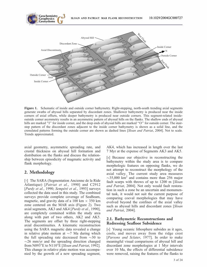
[3] Axial segmentation plays an important role inshaping the abyssal hills of the ridge flanks.Segmentation is thought to be linked to boththermal structure and lithospheric thickness varia-tion, which in turn determines fault orientation,style, and spacing [Shaw and Lin, 1996; Sloan andPatriat, 2004]. At slow-spreading ridges abyssalhill morphology is largely shaped by segment-parallel faulting and by the occurrence of insideand outside corner bathymetry, inherent features ofaxial segmentation. Inside and outside corners referto the sense of segment offset (Figure 1). Atsegment ends shallower bathymetry is producedon the flank facing the axial region of the adjacentsegment, the inside corner, and on the opposing,the outside corner, flank deeper bathymetry isproduced. Mechanical uplift associated with thegeometry of en echelon segmentation in obliquetension contributes to this relief, as does thethermal effect of the adjacent segment. Insidecorner bathymetric highs form as lithosphere islifted from the axial valley floor, past the warmerend of the adjacent segment, and into the ridgemountains. At outside corners, lithosphere beinglifted from the axial valley floor into the ridgemountains is next to slightly older, cooler litho-sphere formed at the adjacent segment and as aresult tends to reside deeper. Inside-outside cornerbathymetry is enhanced as the lithosphere passesfrom the ridge mountains to the flanks [Sloan andPatriat, 2004]. Where the sense of axial offset isconsistent for several segments, the bathymetry ofthe flanks will exhibit systematic asymmetry. In thecase of the study area, three axial discontinuitiesoffset the axial segments to right so that the on theeast flank the northern ends of the segment-definedabyssal hills are shallower than southern ends.Similarly, on the west flank the southern ends ofabyssal hills are shallower than the northern ends.
[4] Abyssal hill distribution and gravity data sug-gest different durations for magmatic episodes.There is some lack of coherence between theepisodicity of abyssal hills and the episodicity ofresidual gravity anomalies and derived crustalthickness variation from coincident and proximalstudies at the MAR. Estimates of abyssal hillepisodicity range from !2 to 7 Myr [e.g., Tucholkeet al., 1997; Maia and Gente, 1998], while therange of residual gravity anomalies and calculatedcrustal thickness episodicity is estimated to be
!3–4 Myr [e.g., Rommevaux et al., 1994]. Whileoverlap exists between the estimates based uponthese two different data types, the discrepancybetween them and the broad range of the formeris enough to warrant further investigation. Inaddition, both negative [Goff et al., 1995; Tucholkeet al., 1997] and positive [Mendel et al., 2003]correlations have been made between abyssal hillsize and crustal thickness at slow-spreading ridges.What is the relationship between abyssal hill for-mation and crustal thickness, if any? Can thisrelationship be used to infer episodicity of mag-matic activity?
[5] The notion of a broad zone of active tectonicdeformation at slow spreading ridges is supportedby modification of crustal structure interpretedfrom gravity [e.g., Rommevaux et al., 1994;Escartın and Lin, 1995; Maia and Gente, 1998]and seismic data [Mutter and Karson, 1992;Canales et al., 2000]. In a study of the CentralIndian Ridge, Sauter et al. [1996] concluded thatabyssal hill formation is not complete until!1.5 Ma at a distance of 20–40 km from the axis.The temporal/spatial extent of active modificationalong the MAR has been linked to the width of thedynamically supported regime estimated to extendto !2–3 Ma/25–30 km off-axis [Sloan andPatriat, 2004]. If seafloor morphology continuesto evolve to the edges of a zone of active defor-mation 50–80 km wide, then are the processes thatcontribute to abyssal hill and discordant zonemorphology operating asynchronously on oppos-ing flanks? What effect does passage from thedynamic regime to the isostatic regime of theflanks have on abyssal hill morphology?
[6] With these issues in mind we reconstructedseafloor bathymetry at 1 Myr intervals for the last10 Ma using gridded SeaBeam bathymetry data(Figure 2), an age grid derived from magneticdata, and rotation poles and angles resulting froma kinematic reconstruction (Table 1) [Sloan andPatriat, 1992]. The relative crustal thicknesswas reconstructed using a similar technique withvalues calculated from residual gravity anomaliesby Rommevaux et al. [1994]. The resulting recon-structions allow us to explore the evolution ofabyssal hill and discordant zone morphologyand its relationship to crustal thickness, spreadingrate, and segmentation. We examine the rolethat passage from the dynamic regime near theaxis to the isostatic regime of the flanks playsin shaping the morphology of abyssal hills anddiscordant zones. We also examine the effects of
GeochemistryGeophysicsGeosystems G3G3 sloan and patriat: mar flank reconstruction 10.1029/2004GC000727
2 of 24
axial geometry, asymmetric spreading rate, andcrustal thickness on abyssal hill formation anddistribution on the flanks and discuss the relation-ship between episodicity of magmatic activity andflank morphology.
2. Methodology
[7] The SARA (Segmentation Ancienne de la RideAtlantique) [Patriat et al., 1990] and C2912[Purdy et al., 1990; Sempere et al., 1993] surveyscollected the data used in this study. The combinedsurveys provide complete coverage of SeaBeam,magnetic, and gravity data of a 100 km " 350 kmzone centered on the MAR axis (Figure 2). Twoaxial segments, AK3 and AK4 [Purdy et al., 1990],are completely contained within the study areaalong with part of two others, AK2 and AK5.The segments are offset by three right-steppingaxial discontinuities. A kinematic reconstructionusing the SARA magnetic data revealed a changein relative plate motion at !7 Ma during whichthe full spreading rate decreased from !30 to!26 mm/yr and the spreading direction changedfrom N093!E to N110!E [Sloan and Patriat, 1992].This change in relative plate motion was accompa-nied by the growth of a new spreading segment,
AK4, which has increased in length over the last7 Myr at the expense of Segments AK3 and AK5.
[8] Because our objective in reconstructing thebathymetry within the study area is to comparemorphologic features on opposing flanks, we donot attempt to reconstruct the morphology of theaxial valley. The current study area measures!35,000 km2 and contains more than 256 majorfault scarps with throws of up to 1200 m [Sloanand Patriat, 2004]. Not only would fault restora-tion in such a zone be an uncertain and monumen-tal task, it would not suit the current purpose ofcomparing coeval morphologies that may haveevolved beyond the confines of the axial valleysuch as abyssal hills and discordant zones [Sloanand Patriat, 2004].
2.1. Bathymetric Reconstructions andRedressing Seafloor Subsidence
[9] Young oceanic lithosphere subsides as it ages,cools, and moves away from the ridge crest[Parsons and Sclater, 1977]. In order to makemeaningful visual comparisons of abyssal hill anddiscordant zone morphologies at 1 Myr intervalsover 10 Ma, the effects of differential subsidencewere removed, raising the features of the flanks to
Figure 1. Schematic of inside and outside corner bathymetry. Right-stepping, north-south trending axial segmentsgenerate swaths of abyssal hills separated by discordant zones. Shallower bathymetry is produced near the insidecorners of axial offsets, while deeper bathymetry is produced near outside corners. This segment-related inside-outside corner asymmetry results in an asymmetric pattern of abyssal hills on the flanks. The shallow ends of abyssalhills are marked ‘‘I’’ for inside corner, and the deep ends of abyssal hills are marked ‘‘O’’ for outside corner. The stair-step pattern of the discordant zones adjacent to the inside corner bathymetry is shown as a solid line, and thecrenulated patterns forming the outside corner are shown as dashed lines [Sloan and Patriat, 2004]. Not to scale.Trends approximated.
GeochemistryGeophysicsGeosystems G3G3 sloan and patriat: mar flank reconstruction 10.1029/2004GC000727sloan and patriat: mar flank reconstruction 10.1029/2004GC000727
3 of 24

the approximate height of the outer ridge moun-tains. Subsidence correction has the benefit ofproducing reconstructed bathymetry images inwhich juxtaposed morphologic features arepresented within the color-depth range of thepresent-day ridge mountains, the proposed zoneof abyssal hill formation.
[10] Parsons and Sclater [1977] arrived at thefollowing theoretical expression for seafloor depthas a function of age:
D tð Þ ¼ D t0ð Þ þ 350 m*t1=2;
where D(t) is depth in meters, D(t0) is depth at theridge crest, estimated at an average of 2500 m[Parsons and Sclater, 1977], and t is seafloor age(Figure 3a). Several other investigators haveproposed revisions to this model based uponthermal considerations [e.g., Abbott et al., 1992;Stein and Stein, 1992; Cochran and Buck, 2001],depth to mid-ocean ridge basalt basement
[Johnson and Carlson, 1992], and dynamic-rheological consideration [Phipps Morgan andSmith, 1992]. These models provide an improvedfit to observed subsidence in lithosphere older than80 Ma, but do not vary significantly from theParsons and Sclater [1977] model for lithosphere0–10 Ma.
[11] Reconstruction of seafloor requires that asubsidence correction be applied to the bathymetry.At age t, the seafloor would have subsided by(Figure 3b):
Dd ¼ 350 m*t1=2:
Subtracting Dd from the bathymetry elevatesseafloor to the initial depth of the ridge crest atwhich it was formed while maintaining the relief ofthe abyssal hills (Figure 3c). This correction doesnot take into account the differential subsidence ofthe lithosphere as a function of age. In order torestore this subsidence curve to seafloor older than
Figure 2. Bathymetry and location map. The SARA survey area is located at 28!–29!N along the MAR Kane-Atlantis supersegment. The survey mapped two full axial segments, AK3 and AK4, and part of AK2 and AK5.Swaths of rugged abyssal hills separated by deeper discordant zones characterize the flanks. Arrows on inset mapindicate present spreading direction of N101!E [Sloan and Patriat, 1992]. Inside corners are labeled I in white;outside corners are labeled O.
GeochemistryGeophysicsGeosystems G3G3 sloan and patriat: mar flank reconstruction 10.1029/2004GC000727
4 of 24

the reconstruction age, tx, a second correction, Ds,is applied (Figure 3d):
Ds ¼ 350 m* t' txð Þ1=2:
Thus the corrected depth of the seafloor for areconstruction at age tx may be expressed as(Figure 3e):
D ¼ D tð Þ ' Ddþ Ds ¼ D tð Þ þ 350 m* t' txð Þ1=2' t1=2h i
:
[12] The gridded bathymetry data provides thevalues for D(t) in which depth values are positivenumbers. The corresponding grid of age valuesneeded to calculate the subsidence corrections canbe derived from magnetic data.
2.2. Age Grid Calculation
[13] The exceptionally closely spaced (!1.5 kmcompared to a typical track spacing of 10–20 km)ship tracks of the SARA survey, required forcomplete SeaBeam swath bathymetry data cover-
Table 1. Rotation Poles Calculated From MagneticAnomaliesa
Anomaly Age, myr Latitude Longitude Angle
2 1.86 80.10! 53.10! 0.48!3 3.85 77.70! 67.70! 0.92!3a 5.69 77.20! 76.30! 1.29!4 7.01 77.50! 52.00! 1.65!4a 8.69 78.50! 23.80! 2.29!5 10.10 80.30! 36.10! 2.67!
aSloan and Patriat [1992].
Figure 3. Subsidence correction. (a) Depth age curve resulting from thermal subsidence of the seafloor derived byParsons and Sclater [1977] shown as heavy gray line; seafloor shown as black line. (b) Subsidence correction.(c) Subsidence-corrected seafloor. (d) Reconstruction of subsidence-corrected seafloor and differential subsidencecorrection for reconstruction time tx. (e) Reconstructed seafloor restored to time tx depth-age curve. See text fordetails.
GeochemistryGeophysicsGeosystems G3G3 sloan and patriat: mar flank reconstruction 10.1029/2004GC000727
5 of 24
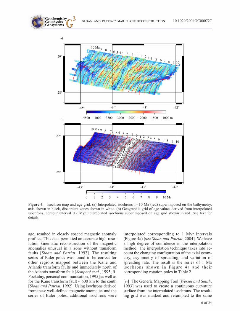
age, resulted in closely spaced magnetic anomalyprofiles. This data permitted an accurate high-reso-lution kinematic reconstruction of the magneticanomalies unusual in a zone without transformfaults [Sloan and Patriat, 1992]. The resultingseries of Euler poles was found to be correct forother regions mapped between the Kane andAtlantis transform faults and immediately north ofthe Atlantis transform fault [Sempere et al., 1995; R.Pockalny, personal communication, 1995] as well asfor the Kane transform fault !600 km to the south[Sloan and Patriat, 1992]. Using isochrons derivedfrom these well-defined magnetic anomalies and theseries of Euler poles, additional isochrons were
interpolated corresponding to 1 Myr intervals(Figure 4a) [see Sloan and Patriat, 2004]. We havea high degree of confidence in the interpolationmethod. The interpolation technique takes into ac-count the changing configuration of the axial geom-etry, asymmetry of spreading, and variation ofspreading rate. The result is the series of 1 Maisochrons shown in Figure 4a and theircorresponding rotation poles in Table 2.
[14] The Generic Mapping Tool [Wessel and Smith,1993] was used to create a continuous curvaturesurface from the interpolated isochrons. The result-ing grid was masked and resampled to the same
Figure 4. Isochron map and age grid. (a) Interpolated isochrons 1–10 Ma (red) superimposed on the bathymetry,axis shown in black, discordant zones shown in white. (b) Geographic grid of age values derived from interpolatedisochrons, contour interval 0.2 Myr. Interpolated isochrons superimposed on age grid shown in red. See text fordetails.
GeochemistryGeophysicsGeosystems G3G3 sloan and patriat: mar flank reconstruction 10.1029/2004GC000727
6 of 24

node spacing as the gridded bathymetry. The maskconfiguration corresponds to the northern andsouthern limits of bathymetry data coverage andthe 10Ma isochrons on the east and west flanks. Thecontoured age grid is shown in Figure 4b with theinterpolated isochrons superimposed upon it.
2.3. Subsidence Correction
[15] The age grid was used to calculate subsidencecorrection grids for ages 0–9 Ma that were appliedto the gridded bathymetry. Examples of the subsi-dence correction grids Dd and Ds for tx = 5 Ma areshown in Figures 5a and 5b. The correction torestore the bathymetry surface to the depth-agecurve, Ds = 350 m*(t ' tx)
1/2, results in null values
Table 2. Rotation Poles Interpolated for 1 MyrIsochrons
Isochron Age, myr Latitude Longitude Angle
1 1 82.5! 53.1! 0.26!2 2 80.5! 55.3! 0.51!3 3 78.5! 64.3! 0.73!4 4 77.6! 68.7! 0.95!5 5 77.0! 74.1! 1.15!6 6 77.6! 69.7! 1.37!7 7 77.5! 52.4! 1.65!8 8 78.5! 33.5! 2.02!9 9 79.0! 26.4! 2.37!10 10 80.2! 35.1! 2.64!
Figure 5. Subsidence correction grids for reconstruction age tx = 5 Ma derived from gridded age values. (a) Griddedthermal subsidence depth correction values. (b) Gridded subsidence restoration curve values. Contour interval 200 m.
GeochemistryGeophysicsGeosystems G3G3 sloan and patriat: mar flank reconstruction 10.1029/2004GC000727
7 of 24

being assigned to nodes with age values less than tx(Figure 5b).
2.4. Bathymetry Reconstruction
[16] The morphologies of the opposing flanks werejuxtaposed by translating the subsidence-correctedbathymetry grid from spherical Mercator to obliqueMercator projection using the interpolated rotationpole corresponding to the reconstruction isochron(Table 2). The corrected bathymetry grid is thenrotated about the corresponding pole twice: onceclockwise by half the rotation angle and thencounter-clockwise by half the rotation angle. Therotated grids are superimposed and clipped alongthe reconstruction isochron. This technique posi-tions the reconstruction isochron at the approxi-mate location of the contemporary spreading axis,allowing us to present the reconstructed bathyme-try with geographic coordinates for reference andscale (Figures 6a–6i). Subsidence-corrected recon-structions corresponding to the magnetic anomalies2, 3, 3a, 4, and 4a as identified directly frommagnetic data by Sloan and Patriat [1992] werecarried out as verification of method accuracy(Figure 7).
[17] A series of profiles was plotted from thesubsidence-corrected bathymetry along conjugateisochrons for each 1 Myr reconstruction to pro-vide additional insight into comparison of juxta-posed flank morphologies (Figure 8). Depthvalues were extracted every 200 m. Distancebetween the first data point of the profiles ofthe west flank (red) and east flank (blue) wasdetermined by calculating the relative distances tothe rotation pole. Discordant zone locations weretranslated from discordant zone traces in mapview (Figure 4a) identified as the base of discor-dant zone walls defining high inside corners.They were plotted profile to profile in Figure 8to delimit segment boundaries on west (red) andeast (blue) flank.
[18] The positions the discordant zones (Figures 4and 6a–6i–12) are derived from the bathymetryand the 1 Myr isochrons are interpolated fromthe magnetic anomalies. Because they are inde-pendent interpretations, it is not unexpected thatthey do not match exactly for every 1 Myrinterval. Overall there is moderate to excellentcoherence between the location of discontinuitiesinterpreted from the bathymetry and the offsetsin interpolated isochrons. Tectonic deformationbeyond the axial valley may contribute to mis-alignment of the traces of the discontinuities and
interpolated isochron offsets or, as in the case ofthe 9 Ma isochron (Figure 6i), it may be anartifact of the interpolation process. The config-uration of magnetic anomaly 5 (10.10 Ma) isconsistent with an axial geometry of two seg-ments, AK3 and AK5, offset by a transform faultnear the middle of the mapped zone [Sloan andPatriat, 1992]. The configuration of magneticanomaly 4 (7.01 Ma) clearly indicates a differentaxial geometry. Between anomaly 5 time andanomaly 4 time the axial geometry transitionsfrom two segments offset by a transform fault tothree segments offset by two non-transform dis-continuities. The initiation and/or rapid growth ofsegment AK4 took place over approximately3 Myr in response to a change in relative platemotion [Sloan and Patriat, 1992]. Althoughanomaly 4a (8.69 Ma) was mapped, it does notgive a clear indication of the geometry of theaxial offset during this transition. In the processof interpolation of 1 Myr isochrons a segment-transform-segment configuration of the interpo-lated 9 Ma isochron was imposed in the absenceof constraining data because it produced a betterfit with the configuration of anomaly 5 than anoblique non-transform discontinuity.
2.5. Relative Crustal ThicknessReconstruction
[19] The reconstruction method (without subsi-dence correction) was applied to a map of relativecrustal thickness derived from the residual mantleBouguer anomaly [Rommevaux et al., 1994](Figure 9). Their model takes into account seafloorbathymetry and thermal subsidence and assumes areference crustal thickness of 5 km. Crustal thick-ness profiles were extracted along 1 Myr isochronsand plotted with corresponding subsidence-corrected depth profiles (Figure 10).
3. Reconstruction Results
[20] Our interpretation of the reconstruction resultsis mindful of the fact that the interpolated isochronsare independent of structural trends to a certaindegree. Magnetic anomalies from which isochronsare derived are a residual expression of thermalconditions at the axis. It is assumed that magneticanomalies are fixed within the crust before brittledeformation ceases such that isochrons and struc-tural trend may intersect. The 1.5 km spacing ofship tracks led to an unusually large number ofidentifications for each magnetic anomaly andresulted in well-defined isochrons, often distinctly
GeochemistryGeophysicsGeosystems G3G3 sloan and patriat: mar flank reconstruction 10.1029/2004GC000727
8 of 24

Figure 6. Subsidence-corrected bathymetry reconstructions, 1–9 Ma. The reconstruction technique positions thereconstructed isochron at the approximate location of the contemporary axis, allowing the reconstruction to bepresented with geographic coordinates for reference and scale. The gridlines that appear within the geographic framecorrespond to the corrected bathymetry grid before rotation. Contour interval 200 m, traces of discordant zonesshown in white, reconstruction isochron shown in gray, 1 Myr isochrons older than the reconstruction are shown infine white lines. Inside corners are labeled ‘‘I’’ in white; outside corners are labeled ‘‘O’’.
GeochemistryGeophysicsGeosystems G3G3 sloan and patriat: mar flank reconstruction 10.1029/2004GC000727
9 of 24

sigmoid, that permitted accurate isochron superpo-sition without the constraint of fracture zones.
3.1. Bathymetric Reconstruction andAbyssal Hills
[21] Abyssal hills and discordant zones are themajor morphologic features at the segment scale.
For the purpose of identification and distributionanalysis, we use a widely accepted definition ofabyssal hills as bathymetric highs elongate parallelto the spreading segment, bound by fault scarpsand separated by intervening lows that are alsoelongate parallel to the spreading segment. Inter-vening lows tend to be narrower than abyssal hillsand both are limited in the axis-parallel direction
Figure 6. (continued)
GeochemistryGeophysicsGeosystems G3G3 sloan and patriat: mar flank reconstruction 10.1029/2004GC000727
10 of 24

by discordant zones. The shallowest points ofabyssal hills tend to be associated with insidecorners of axial discontinuities. Along the crest ofmost abyssal hills, bathymetry slopes away fromthe inside corner high toward deeper bathymetryassociated with outside corners. The interpolatedisochrons lie parallel or moderately oblique to allof the different components of abyssal hill mor-
phology including hill crests, inward and outwardfacing slopes, and intervening lows.
[22] The 1 Ma and 2 Ma reconstructions juxtaposerugged terrain that shows narrow deeper discordantzones and little clear evidence of distinct inside oroutside corner bathymetry (Figures 6a and 6b).Inside and outside corner bathymetry becomes
Figure 6. (continued)
GeochemistryGeophysicsGeosystems G3G3 sloan and patriat: mar flank reconstruction 10.1029/2004GC000727
11 of 24

more apparent at 3 Ma as do discordant zones(Figure 6c). From 4 Ma on, the isochrons regularlyrun along both inside and outside corner bathym-etry and roughly 1/3 of the segments’ length ischaracterized by the sediment-filled deeps associ-ated with discordant zones (Figures 6d–6i). Seg-ment AK4 deviates from this trend for the 6 Maand 7 Ma reconstructions probably due to local
reorganization in response to changes in relativeplate motion at about this time [Sloan and Patriat,1992].
[23] Reconstruction juxtaposes a range of morphol-ogies from abyssal hill crest with abyssal hill crestto abyssal hill crest with intervening low. Recon-struction of Segments AK3 at 4 Ma, 6 Ma, and 7
Figure 6. (continued)
GeochemistryGeophysicsGeosystems G3G3 sloan and patriat: mar flank reconstruction 10.1029/2004GC000727
12 of 24

Ma and Segment AK4 at 3 Ma, 6 Ma, and 8 Majuxtapose conjugate abyssal hill crests or conjugateintervening lows indicating relatively symmetricabyssal hill distribution for those particular agesand segments (Figures 6 and 8, Table 3). Otherreconstructions, such as Segment AK3 at 3 Ma,5Ma, and 8Ma and Segment AK4 at 5Ma and 7Ma,juxtapose an intervening low with an abyssal hillcrest. Approximately half of reconstructions 3 Maand older juxtapose abyssal hills or intervening lowswith corresponding morphology. The other halfjuxtapose abyssal hills with intervening lows orsome other combination indicative of asymmetricdistribution of abyssal hills on the flanks.
[24] Depth profiles extracted along east (blue) andwest (red) 1 Myr isochrons (Figure 8) furtherillustrate the range of morphologies juxtaposedby reconstruction. Abyssal hills exhibiting highinside corner relief are juxtaposed with interveninglows as in the 7 Ma reconstruction of SegmentAK5. The alignment of inside and outside cornerbathymetry on opposing flanks can be seen in thejuxtaposition conjugate abyssal hill crests in the7 Ma reconstruction of Segment AK3.
[25] The high percentage of asymmetry in inter-polated isochrons is not an artifact of interpolation,as evidenced by the comparable level of asymme-try obtained for reconstruction of isochronsderived directly from observed magnetic anoma-
lies (Figure 7). Approximately 64% of anomaly-isochrons reconstructions juxtapose abyssal hillsor intervening lows symmetrically and 36% resultin asymmetric juxtapositions. This comparisondoes not rule out error in interpolating the 1 Myrisochrons, but it does confirm that asymmetricjuxtaposition of abyssal hills and intervening lowsoccurs frequently within the study area and pro-vides a certain confidence in the interpretation ofasymmetric abyssal hill formation.
[26] As a means of identifying individual abyssalhills we have traced the 2100 m contour on a mapof the subsidence-corrected bathymetry (Figure 11).The mean depth of the subsidence-correctedbathymetry is !2400 m and the 2100 m contourwas chosen to distinguish tectonic-derived bathym-etry from volcanic-derived bathymetry (300 m isthe maximum height of volcanic features on thevalley floor in the study area [Briais et al., 2000]).Thus the choice of the 2100 m contour, althoughsomewhat arbitrary since it does not delimit theabyssal hills along their fault scarp boundary,provides an approximation of the abyssal hilldistribution in time and space. Abyssal hills ofSegment AK3 occur at a spacing of !1 Myr exceptat !6–7 Ma on the west flank and at !5–6 Maon the east flank. Although their distribution isspatially asymmetric, the number of Segment AK3abyssal hills formed during the last 10 Ma is the
Figure 6. (continued)
GeochemistryGeophysicsGeosystems G3G3 sloan and patriat: mar flank reconstruction 10.1029/2004GC000727
13 of 24

same on both flanks. Segment AK4 abyssal hillsoccur every !2 Myr and are asymmetricallydistributed with respect to the isochrons. From0 Ma to 3 Ma too little of Segment AK5 iscontained within the study area to identify abyssalhills with confidence. From 3 Ma to 10 Ma,Segment AK5 abyssal hills occur every !1–2 Myr, distributed asymmetrically on the flanks.
3.2. Discordant Zone Alignment
[27] At slow-spreading ridges, discordant zonesare generally regarded as aligned series of deep,irregular, elliptical basins forming troughs thatmarks the traces of axial discontinuities and sepa-
rate high inside corner bathymetry of one segmentfrom low outside corner bathymetry of the next.The long axis of the elliptical basins tends to beparallel to the spreading axis. Discordant zonewalls that form the edge of high inside cornerbathymetry tend to display a blocky stair-stepconfiguration while the walls along outside cornerbathymetry tend to have a crenulated configuration(Figure 1) [Sloan, 1993; Sloan and Patriat, 2004].The floor of the discordant zones appears relativelysmooth suggesting the role of catchment basin formass-wasted sediments. The base of the steep wallforming the edge of the high inside corner bathym-etry has been delineated as the location of thediscordant zones. Juxtaposition of the flanks shows
Figure 7. Subsidence-corrected bathymetry reconstructions, anomaly 2 through anomaly 4a. The reconstructiontechnique positions the reconstructed isochron at the approximate location of the contemporary axis, allowing thereconstruction to be presented with geographic coordinates for reference and scale. The gridlines that appear withinthe geographic frame correspond to the corrected bathymetry grid before rotation. Traces of discordant zones shownin white, reconstruction isochron in gray.
GeochemistryGeophysicsGeosystems G3G3 sloan and patriat: mar flank reconstruction 10.1029/2004GC000727
14 of 24

that the steep walls defining the high insidecorner rather than the middle of the sediment-filled basins or the crenulated walls of thediscordant zones tend to be aligned by recon-struction (Figures 6a–6i and 7).
3.3. Crustal Thickness Reconstruction andAbyssal Hills
[28] Reconstruction of crustal thickness variationcalculated from gravity data by Rommevaux et al.
[1994] often shows juxtaposition of relatively thickcrust from one flank with relatively thin crust of theopposing flank (Figure 9). Examining crustal thick-ness along strike of reconstructed isochrons wenote that at 9 Ma, when Segment AK4 is presumedto have zero length, the crust is thinnest at whatappears to be an axial discontinuity between Seg-ments AK3 and AK5 and thickens along the axis ofthese segments. From 8 Ma to 5 Ma, Segment AK4lengthens while generating a zone of relativelythick crust near its center. During this same period
Figure 8. Subsidence-corrected, along-isochron depth profiles. Depth profiles of subsidence-corrected bathymetryjuxtaposed by reconstruction extracted along isochrons on the west (red) and east (blue) flank. Traces of discordantzones on the west (red) and east (blue) flank are shown as dashed lines. Reference depth line at 2500 m; V.E. = 1:100.
GeochemistryGeophysicsGeosystems G3G3 sloan and patriat: mar flank reconstruction 10.1029/2004GC000727
15 of 24

Figure 9. Crustal thickness reconstruction 1–9 Ma. Contour interval 0.5 km, discordant zones shown in black. Thereconstruction technique positions the reconstructed isochron at the approximate location of the contemporary axis,allowing the reconstruction to be presented with geographic coordinates for reference and scale. The gridlines thatappear within the geographic frame correspond to the original crustal thickness grid before rotation. Crustal thicknessmap calculated from gravity data by Rommevaux et al. [1994], with interpolated isochrons in gray, lower right.
GeochemistryGeophysicsGeosystems G3G3 sloan and patriat: mar flank reconstruction 10.1029/2004GC000727
16 of 24

Segments AK3 and AK5 display thicker crust atoutside corners and thinner crust at inside corners.From 5 Ma until 1 Ma Segment AK4 also displaysthicker crust at outside corners and thinner crust atinside corners.
[29] In addition to crustal thickness variationalong isochrons, variation of crustal thicknessthrough time is apparent along flow lines. Crustal
thickness of Segment AK3 varies by about 1 kmroughly every !2–4 Myr and Segment AK4every !2–3 Myr. Given the extent of data cover-age, it is difficult to resolve the periodicity ofcrustal thickness fluctuations; however, it is clearthat the fluctuations of one segment are not inphase with those of adjacent segments. Crustalthickness variation appears to be associated withchanging segment length. During periods of gen-
Figure 10. Subsidence-corrected depth profiles plotted along isochrons with corresponding crustal thicknessprofiles, 0–9 Ma. Depth and crustal thickness vertical scales are arbitrarily aligned. Dashed vertical lines markdiscordant zone locations.
GeochemistryGeophysicsGeosystems G3G3 sloan and patriat: mar flank reconstruction 10.1029/2004GC000727
17 of 24

eration of thicker crust, Segments AK3 and AK4lengthened or advanced at one or both ends.During periods of generation of thinner crust bothsegments retreated.
[30] Crustal thickness values plotted along iso-chrons with corresponding subsidence-correctedbathymetry (Figure 10) present a consistent patternwith respect to segmentation. The calculated crustal
Figure 11. Abyssal hill identification. Bathymetry corrected for thermal subsidence only. Trace of 2100 m contouris used as an approximation for abyssal hill identification. Interpolated isochrons shown in red, traces of discordantzones shown in white.
Figure 12. Abyssal hills and crustal thickness. Abyssal hill identifications superimposed on calculated crustalthickness map. Contour interval 0.5 km.
GeochemistryGeophysicsGeosystems G3G3 sloan and patriat: mar flank reconstruction 10.1029/2004GC000727
18 of 24

thickness varies approximately ±1.5 km from thereference thickness of 5 km. The profile plottedalong the axis (0 Ma) reveals variable but relativelythick crust beneath the central part of SegmentAK4. The crust thins toward both segment endsfrom !5.5 km to !4.5 km. The axial profile passesover the saddle at the discontinuity between AK4and AK5. This relative bathymetric high corre-sponds to slightly thicker crust. The pattern ofcrustal thickness beneath the segment centers atthe axis has changed by 2 Ma. From 2 to 10 Ma thethickest crust tends to occur beneath the outsidecorner bathymetry and the thinnest crust beneaththe inside corner bathymetry. Discordant zonestend to be associated with areas of steepest gradientof crustal thickness.
[31] When abyssal hill distribution based onbathymetry is superposed onto a map of crustalthickness (Figure 12) we observe that along flowlines broader, more robust abyssal hills correspondto areas of thicker crust while narrower abyssalhills tend to correspond to areas of thinner crust.Also apparent in Figure 12 is that the wavelengthof abyssal hill relief along flow lines is shorter thanthat of crustal thickness variation. The greatestrelief and shallowest bathymetry along isochrons,which occurs at the inside corner highs, correspondto thinner and occasionally thinnest crust while theinverse is true for outside corners.
3.4. Abyssal Hill Morphology, RelativePlate Motion, and Segmentation
[32] Due to reorganization of relative plate motionat !7–8 Ma, the spreading rate dropped from30 mm/yr to 23 mm/yr and then graduallyincreased to the present-day rate of 26 mm/yr[Sloan and Patriat, 1992]. Spreading directionchanged from N093!E to N110!E at !7 Ma andthen changed gradually to the present-day directionof N101!E. Coincident with the change in relativeplate motion at !7–8 Ma, Segment AK4 began togrow while Segments AK5 to the south and AK 3to the north retreated. The southern end of Segment
AK4 made a steady advance toward the southwhile the northern end alternately advanced andretreated (Figures 6a–6i). The present-day lengthof Segment AK4 is greater than it has been at anytime during the last 10 Ma. The rapid growth ofSegment AK4 at !7–5 Ma corresponds withthickening crust and slightly precedes formationof the broadest and most robust AK4 abyssal hills.Retreat of Segment AK3 is associated with gener-ation of thinner crust and formation of somewhatless robust abyssal hills.
4. Discussion
4.1. Stages of Evolution
[33] Distinct stages of evolution are apparent inthe 1 Myr reconstruction of the bathymetry(Figures 6a–6i). Contrasts between reconstructionsof the 1 Ma and 2 Ma isochrons and reconstruc-tions of isochrons 3 Ma and older highlight differ-ences between the morphology of the ridgemountains and that of the flanks. The inside andoutside corner asymmetry and discordant zonesassociated with axial segmentation at slow-spreading ridges are present at 1 Ma and 2 Mabut not to the degree that is characteristic of ridgeflank morphotectonic fabric (4 Ma. This is con-sistent with the suggestion that flank morphologycontinues to evolve to an age of !2–3 Ma or!30–40 km off-axis [Sloan and Patriat, 2004]. Itis evident that this evolution of morphology occursalong the entire segment length; i.e., shallowing ofinside corner bathymetry and deepening of outsidecorner bathymetry as abyssal hills form at the outeredge of the ridge mountains.
[34] Continued evolution of the crust to an age of!2 Ma is also evident in patterns of calculatedcrustal thickness. Crustal thickness for the present(0 Ma) and the 1 Ma and 2 Ma reconstructionsshows a circular pattern of thicker crust at thecenter of Segment AK4 that thins symmetricallyalong the axis toward the segment ends (Figure 9).Reconstructions of crustal thickness for isochrons
Table 3. Morphologies Juxtaposed by Reconstruction of 3 Ma to 9 Ma Isochronsa
3 Ma 4 Ma 5 Ma 6 Ma 7 Ma 8 Ma 9 Ma
East West East West East West East West East West East West East West
AK3 L-H L-L H-L L-L H-H L-H H-HAK4 H-H L-L L-H L-L H-L L-L -AK5 - H-L L-H L-H H-L H-L L-L
aH represents abyssal hills, and L represents intervening lows.
GeochemistryGeophysicsGeosystems G3G3 sloan and patriat: mar flank reconstruction 10.1029/2004GC000727
19 of 24

3 Ma and older display an asymmetric pattern withrespect to segmentation in which thicker crustoccurs toward the outside corner and thinner crusttoward the inside corner. Crustal thickness profilesalong the axis and 1 Ma isochron show character-istics distinct from those along the 3 Ma isochron.Indeed along the 3 Ma isochron the pattern ofthicker crust beneath deep outside corner bathym-etry and thin crust beneath shallow high insidecorner bathymetry typical of the flanks is estab-lished. This shift has been noted by several inves-tigators both in the study area and at other locationson the flanks of slow-spreading ridges [e.g.,Rommevaux et al., 1994; Escartın and Lin, 1995;Maia and Gente, 1998]. Escartın and Lin [1995] ina study of axial segments along the MAR founda sudden drop in coherence between gravity andbathymetry data at !2.5 Ma and interpreted this asmodification of the crust by normal faulting. Theirinterpretation of normal faulting is consistent withthe results of the reconstruction and with an anal-ysis of fault scarps conducted in the study areawhere the faulting in crust !2.5 Ma occurs at theouter edge of the ridge mountains [Sloan andPatriat, 2004].
4.2. Obliquity of Abyssal Hills to the RidgeTrend
[35] In previous work we have suggested thatabyssal hills form as young lithosphere passesout of the near-axis dynamic regime into theisostatic regime of the flanks [Sloan and Patriat,2004]. We assume that the thermally supporteddynamic regime is aligned with the general trendof the ridge crest, !N035!E (Figure 13a) and thetrend of the segmented axial valley and walls is!N011!E. Abyssal hill trends are largely definedby faults trending parallel to the axial valley walls.Thus, as the N011!E structural trend of the ridgemountain lithosphere passes through the N035!Etrending transition from dynamic to isostaticregime, they do so obliquely (Figure 13b). Theoutside corner passes into the transition zonebefore the inside corner which is left within thethermally supported, dynamic regime longer. Thismay enhance elevation of inside corners and ac-tively depress outside corners. Within the crust andupper mantle, the response to oblique passagethrough the transition zone may be accommodatedby development or reactivation of normal faults. Atdepth, the lithosphere may respond to this transi-tion by flow or aseismic slip. In order to accom-modate oblique passage through the transition fromdynamic to isostatic regime individual blocks of
lithosphere must respond independently. Maia andGente [1998] suggested that throughgoing faultsexist at axial discontinuities and Sempere et al.[1995] proposed that lithosphere generated atadjacent segments may be decoupled to the extentthat it can respond individually to local and per-haps distal stress fields over several million years.Thus segment-defined abyssal hill blocks could besufficiently decoupled to respond independently indirections both across and along the ridge.
4.3. Asymmetric Flank Morphology,Crustal Thickness, Spreading Rate, andMagmatic Activity
[36] If abyssal hill distribution were symmetricabout the spreading axis, reconstruction alongisochrons would reassemble abyssal hills on theeast flank with corresponding abyssal hills onthe west flank. The same would be true forcorresponding lows between abyssal hills. Instead,the reconstructions present a more complex rangeof juxtapositions. The combination of abyssal hillcrest to abyssal hill crest as well as abyssal hillcrest to intervening low and everything in betweensuggests an essentially asymmetric nature foryoung oceanic lithosphere evolution. Even thoughanomalies and isochrons are generally oblique toabyssal hill trends, the angle between these trendsis not large enough to cause the observed asym-metry in reconstructions. This asymmetry mayhave a variety of sources, including variations incrustal thickness, spreading rate asymmetry, andgeometry of the plate boundary leading to inde-pendent history of tectonic evolution of each flank.
[37] A variety of relationships between crustalthickness and abyssal hill size and periodicity hasbeen proposed [e.g., Goff et al., 1995; Tucholke etal., 1997; Mendel et al., 2003]. Temporal crustalthickness variation along flow lines is thought to bethe result of fluctuation in magmatic activity andvolume of crustal accretion [e.g., Rommevaux etal., 1994; Tucholke and Lin, 1994; Mendel et al.,2003]. Various frequencies have been proposed foroscillations in magmatic activity at slow-spreadingridges on the basis of abyssal hill periodicity: e.g.,!2 Myr [Lin et al., 1990; Tucholke and Lin, 1994],3–4 Myr [Bonatti et al., 2003], !0.4 Myr [Mendelet al., 2003]. The periodicity of fluctuations inrelative crustal thickness within the study areacan be estimated at !2–4 Myr for Segment AK3and !2–3 Myr for Segment AK4. The periodicityof abyssal hill formation at Segment AK3 is!1 Myr and at Segment AK4 is !2 Myr. These
GeochemistryGeophysicsGeosystems G3G3 sloan and patriat: mar flank reconstruction 10.1029/2004GC000727
20 of 24

two segments appear to have independent histo-ries with regard to abyssal hill formation andcrustal thickness variation. Although the nature ofthe relationship between crustal thickness andabyssal hill formation is unclear, we do observethat the largest, most robust abyssal hills occurwhere the crust is relatively thick (Figure 12).This may be in part due to the tendency of faultsthat bound abyssal hills to form at greaterintervals in thicker crust [Shaw and Lin, 1993]
resulting in abyssal hills with greater relief and alarger ‘‘footprint.’’
[38] Spreading rate has been found to vary onopposing flanks of the MAR by as much as 21%as well as from segment to segment over the last10 Ma [Sloan and Patriat, 1992; Sempere et al.,1995]. From anomaly 5 (10.10 Ma) to anomaly 3(3.85 Ma) spreading rate was faster to the west andfrom anomaly 2 (1.86 Ma) to the present spreading
Figure 13. Schematic of oblique passage of abyssal hills. (a) Relative trends of the major features of the MARwithin the study area: Axial valley trend N011!E, spreading direction N101!E, and trend of the ridge crest andthermally supported dynamic regime N035!E. (b) The thermally supported dynamic regime near the spreading axis isshown parallel to the trend of the ridge crest. Red to gray gradational shading indicates dynamic-transition-isostaticregimes of the plate boundary in map. Abyssal hill trends (dashed black lines) tend to be parallel to the axial valleywalls (blue lines). As the abyssal hills pass through the transition from dynamic to isostatic regime, they do soobliquely, their outside corner passing into the transition zone before the inside corner. The inside corner remainswithin the thermally supported dynamic regime longer, which may enhance elevation of inside corners anddepression of outside corners. Not to scale. Trends approximated in the block diagram. Inside corner bathymetry ismarked with ‘‘I,’’ and outside corner bathymetry marked with ‘‘O’’ as for Figure 1.
GeochemistryGeophysicsGeosystems G3G3 sloan and patriat: mar flank reconstruction 10.1029/2004GC000727
21 of 24

has been faster to the east. This reversal of spread-ing rate asymmetry occurred at approximatelyanomaly 3 (3.85 Ma). The asymmetric pattern ofcrustal thickness on opposing flanks corresponds tothis spreading rate asymmetry. Crust accreted onthe west flank from anomaly 5 (10.10 Ma) toanomaly 3 (3.85 Ma) time is thicker than thataccreted on the east flank during this period. Thereversal of spreading rate asymmetry at anomaly 2(1.86 Ma) to the present is matched by accretion ofthicker crust on the east flank.
[39] This pattern of spreading rate asymmetry andcrustal thickness corresponds with episodes ofsegment propagation and retreat. From anomaly4a through anomaly 3, Segment AK4 appears ofhave propagated steadily at its southern end andfluctuated between propagation and retreat at itsnorthern end (Figure 7). This southward propaga-tion of Segment AK4 corresponds to faster spread-ing and accretion of thicker crust to the west.Propagation of Segment AK4 northward fromanomaly 2 to present while its southern endremained relatively stationary corresponds to fasterspreading to the east for this time. Since propagat-ing segments are likely to be magmatically robustand transfer crust from one flank to another, prop-agation may thus contribute to accretion of thickercrust and spreading asymmetry. In addition, thistransfer of crust may account to some degree for thesinuosity of magnetic anomalies and the occasionalincoherence of magnetic data near discordant zoneremarked upon by Sloan and Patriat [1992].
[40] Segment propagation is generally thought tobe associated with enhanced magmatic activity.Enhanced magma supply to the axis near 28!300Nmay be the cause of initiation and/or propagation ofSegment AK4 along with the elimination of the!23 km long transform fault that appears to haveexisted there 10 Ma. Propagation of Segment AK4may have contributed to spreading asymmetry andaccretion of thicker crust and thereby formationof larger abyssal hills. While Segment AK4 prop-agated steadily southward, the west flank spreadfaster, accreted thicker crust, and formed largerabyssal hills than the east flank. When SegmentK4 began to propagate northward, spreadingasymmetry reversed and the east flanks beganlarger abyssal hills than the west flank. On the basisof these observations we propose that enhancedmagmatic activity and associated segment propaga-tion contributes to formation of larger abyssal hillson one flank than on the other, contributing toasymmetric ridge flank morphology.
[41] The large percentage of asymmetric juxtapo-sitions of abyssal hills in reconstruction may alsobe attributed in part to variation of coeval abyssalhill size on opposing flanks. Juxtaposition of anabyssal hill crest to the side of an abyssal hill oreven an intervening low on the opposing flank ismore probable if the reconstruction juxtaposed alarger, more robust abyssal hill with one that isnarrower and less robust. However, the spreadingrate of each of the segments within the study area isalmost constantly asymmetric while 53% of recon-structions of abyssal hills juxtapose asymmetricmorphologies and 47% juxtapose symmetric mor-phologies. The roughly fifty-fifty distribution insymmetric/asymmetric juxtaposition is a randomdistribution. This constitutes a strong argument insupport of development of abyssal hills outside theaxial zone and independently on opposing flanks.
4.4. Discordant Zone Alignment
[42] The sediment-filled basins, typically associatedwith discordant zones, tend to be juxtaposed withshallow inside corner bathymetry in reconstruction(Figures 6a–6i). Their long axes align with inter-vening lows between abyssal hills. Searle et al.[1998] suggested that these deep sediment-filledbasin formed diffuse boundaries as the result ofaxial discontinuity position instability on the orderof !1 Myr. However, the proposed back and forthwandering of discontinuities is not reflected in thesteep walls of the discordant zones that correspondto the edge of inside corner highs. Instead, theinside corner high present a blocky stair-stepconfiguration that appears to follow the directionof propagation of the axial discontinuity on atimescale of 2–3 Myr (Figure 1). Consistentalignment in reconstruction of these steep stair-step walls of the discordant zones supports thehypothesis that the fault bound edge of high insidecorner bathymetry is the location of the boundarybetween segments on the flanks and that thesediment-filled basins typically associated withdiscordant zones reflect outside corner bathymetry[Sloan and Patriat, 2004]. That these basins arenot well developed in reconstructions of the 1 Maand 2 Ma isochrons supports the notion that theoutside corner of the segment as well as the insidecorner undergoes tectonic enhancement beyond theconfines of the axial valley.
5. Conclusions
[43] Reconstruction of subsidence-corrected MARbathymetry at 1 Myr intervals between 28! and
GeochemistryGeophysicsGeosystems G3G3 sloan and patriat: mar flank reconstruction 10.1029/2004GC000727
22 of 24

29!N juxtaposes a variety of coeval morphologiesand crustal thickness from opposing ridge flanksand crustal thickness, providing insights into theevolution of young oceanic lithosphere, abyssal hillformation, discordant zones and their relationshipto fluctuation of magmatic activity. We draw thefollowing conclusions and propose that they may begeneralized and applied to slow-spreading ridges.
[44] 1. Continued tectonic deformation and evolu-tion of the morphotectonic fabric to at least an ageof !2–3 Ma is evident in bathymetric and calcu-lated crustal thickness reconstructions.
[45] 2. Inside and outside corner relief may beenhanced by oblique passage of the lithospherethrough the transition from dynamic to isostaticregime of the ridge flanks within the ridge moun-tains. Outside corners pass into the isostaticdomain first leaving the inside corners within thethermally supported dynamic regime near the axis.
[46] 3. Abyssal hill formation may occur asynchro-nously on opposing flanks and independently atadjacent segments contribution to asymmetric pat-terns of abyssal hill distribution that vary fromsegment to segment and from flank to flank.
[47] 4. Abyssal hill size and crustal thickness havefluctuated over the last 10 Ma in the study area.There is a positive correlation between abyssal hillsize and crustal thickness though the frequency ofabyssal hill formation and crustal thickness varia-tion do not appear to correspond.
[48] 5. The two major factors affecting asymmetricridge flank morphology are found to be sense ofaxial offset and segment propagation or retreatattendant upon fluctuations in magmatic activity.Sense of axial offset determines the relative distri-bution of inside and outside corner bathymetry onthe flanks. Enhanced magma supply and associatedsegment propagation may contribute to half-spreading rate asymmetry, accretion of thickercrust, and formation of larger abyssal hills on thefaster spreading flank.
[49] 6. The deep, aligned sediment-filled basinstypically identified as discordant zones are anexpression of outside corner bathymetry. Discor-dant zones are located at the base of the steep stair-step walls that bind the inside corner ends ofabyssal hills.
Acknowledgments
[50] We would like to thank C. Rommeveau-Jestin forproviding the gravity-derived crustal thickness grid used in
this study, J. Dyment and J.-Y. Royer for devising a straight-forward and neat method for using GMT to display recon-structions, Marie-Helene Cormier and Enrico Bonatti for theirthoughtful reviews of the manuscript, the Captain and crew ofthe R/V Jean Charcot, and the SARA Scientific Party. Fund-ing to support this work came in part from IFERMER andCNRS-INSU DBT grant 91-559 Theme Dynamique Globale,Institut de Physique du Globe de Paris, and the George N.Shuster Fellowship from Lehman College, City University ofNew York.
References
Abbott, D. H., C. A. Stein, and O. Diachok (1992), Topo-graphic relief and sediment thickness: Their effect on thethermal evolution of the oceanic crust, Geophys. Res. Lett.,19, 1975–1978.
Bonatti, E., M. Ligi, D. Brunelli, A. Cipriani, P. Fabretti,V. Ferrante, L. Gasperini, and L. Ottolini (2003), Mantlethermal pulses below the Mid-Atlantic Ridge and temporalvariation in the formation oceanic lithosphere, Nature, 423,499–505.
Briais, A., H. Sloan, B. L. Murton, and L. P. Parson (2000),Accretionary processes in the axial valley of the Mid-Atlantic Ridge 27!–30!N from TOBI side-scan sonarimages, Mar. Geophys. Res., 21, 87–119.
Canales, J. P., R. S. Detrick, J. Lin, J. A. Collins, and D. R.Toomey (2000), Crustal and upper mantle seismic structurebeneath the rift mountains and across a nontransform offsetat the Mid-Atlantic Ridge (35!N), J. Geophys. Res., 105,2699–2719.
Cochran, J. R., and W. R. Buck (2001), Near-axis subsidencerates, hydrothermal circulation, and thermal structure ofmid-ocean ridge crests, J. Geophys. Res., 106, 19,233–19,258.
Escartın, J., and J. Lin (1995), Ridge offsets, normal faulting,and gravity anomalies of slow spreading ridges, J. Geophys.Res., 100, 6163–6177.
Goff, J. A., B. E. Tucholke, J. Lin, G. E. Jaroslow, and M. C.Kleinrock (1995), Quantitative analysis of abyssal hills in theAtlantic Ocean: A correlation between inferred crustal thick-ness and extensional faulting, J. Geophys. Res., 100,22,509–22,522.
Johnson, H. P., and R. L. Carlson (1992), Variation of seafloordepth with age: A test of models based on drilling results,Geophys. Res. Lett., 19, 1971–1974.
Lin, J., G. M. Purdy, H. Schouten, J.-C. Sempere, andC. Zervas (1990), Evidence from gravity data for focusedmagmatic accretion along the Mid-Atlantic Ridge, Nature,344, 627–632.
Maia, M., and P. Gente (1998), Three-dimensional gravity andbathymetry analysis of the Mid-Atlantic Ridge between20!N and 24!N: Flow geometry and temporal evolution ofthe segmentation, J. Geophys. Res., 103, 951–974.
Mendel, V., D. Sauter, C. Rommevaux-Jestin, P. Patriat,F. Lefebvre, and L. M. Parson (2003), Magmato-tectoniccyclicity at the ultra-slow spreading Southwest Indian Ridge:Evidence from variations of axial volcanic ridge morphologyand abyssal hills pattern, Geochem. Geophys. Geosyst., 4(5),9102, doi:10.1029/2002GC000417.
Mutter, J. C., and J. A. Karson (1992), Mechanical extensionof oceanic lithosphere at slow-spreading ridges: Primaryinfluence on morphology and segmentation, Eos Trans.AGU, 73, 286.
GeochemistryGeophysicsGeosystems G3G3 sloan and patriat: mar flank reconstruction 10.1029/2004GC000727
23 of 24

Parsons, B., and J. G. Sclater (1977), An analysis of the varia-tion of ocean floor bathymetry and heat flow with age,J. Geophys. Res., 82, 803–827.
Patriat, P., C. Deplus, C. Rommevaux, H. Sloan, P. Hunter,and H. Brown (1990), Evolution of the segmentation of theMid-Atlantic Ridge between 28! and 29!N during the last10 Ma: Preliminary results from the SARA cruise (R/V JeanCharcot, May 1990), Eos Trans. AGU, 71, 1629.
Phipps Morgan, J., and W. H. F. Smith (1992), Flattening ofthe sea-floor depth-age curve as a response to asthenosphericflow, Nature, 359, 524–527.
Purdy, G. M., J.-C. Sempere, H. Schouten, D. L. Dubois, andR. Goldsmith (1990), Bathymetry of the Mid-Atlantic Ridge,24!–31!N, Mar. Geophys. Res., 12, 247–252.
Rommevaux, C., C. Deplus, P. Patriat, and J.-C. Sempere(1994), Three-dimensional gravity study of the Mid-AtlanticRidge: Evolution of the between 28! and 29!N, J. Geophys.Res., 99, 3015–3029.
Sauter, D., J.-M. Nafziger, H. Whitechurch, and M. Munschy(1996), Segmentation and morphotectonic variations of theCentral Indian Ridge (21!100S–22!250S), J. Geophys. Res.,101, 20,233–20,256.
Searle, R. C., P. A. Cowie, N. C. Mitchell, S. Allerton,C. J. MacLeod, J. Escartın, S. M. Russell, P. A.Slootweg, and T. Tanaka (1998), Fault structure anddetailed evolution of a slow spreading ridge segment:The Mid-Atlantic Ridge at 29!N, Earth Planet. Sci.Lett., 154, 167–183.
Sempere, J.-C., J. Lin, H. S. Brown, H. Schouten, andG. M. Purdy (1993), Segmentation and morphotectonicvariation along a slow-spreading center: The Mid-AtlanticRidge (24!000N–30400N), Mar. Geophys. Res., 15, 153–200.
Sempere, J.-C., P. Blondel, A. Briais, T. Fujiwara, L. Geli,N. Isezaki, J.E. Pariso, L. Parson, P. Patriat, andC. Rommevaux (1995), The Mid-Atlantic Ridge between
29!N and 31!N in the last 10 Ma, Earth Planet. Sci.Lett., 130, 45–55.
Shaw, P. R., and J. Lin (1996), Models of ocean ridge litho-spheric deformation: Dependence on crustal thickness,spreading rate, and segmentation, J. Geophys. Res., 101,17,977–17,992.
Shaw, W. J., and J. Lin (1993), Causes and consequences ofvariation in faulting style at the Mid-Atlantic Ridge, J. Geo-phys. Res., 98, 21,839–21,851.
Sloan, H. (1993), Les flancs de la Dorsale Medio-Atlantiqueentre 28! et 29!N, de 0 a 10 Ma: Le role de la segmentationaxiale dans la fabrique du relief, these de doctorat, Univ. deParis 6, Paris.
Sloan, H., and P. Patriat (1992), Kinematics of the NorthAmerican-African Plate Boundary between 28! and 29!Nduring the last 10 Ma: Evolution of the axial geometry,spreading rate and direction, Earth Planet. Sci. Lett., 113,323–341.
Sloan, H., and P. Patriat (2004), Generation of morphotectonicfabric on the Mid-Atlantic Ridge flanks, 28! to 29!N:Implications for the limits of tectonic deformation andabyssal hill formation, Geochem. Geophys. Geosyst., 5,Q02004, doi:10.1029/2003GC000584.
Stein, C. A., and S. Stein (1992), A model for the globalvariation in oceanic depth and heat flow with lithosphericage, Nature, 359, 123–129.
Tucholke, B. E., and J. Lin (1994), A geological model for thestructure of ridge segments in slow spreading ocean crust,J. Geophys. Res., 99, 11,937–11,958.
Tucholke, B. E., J. Lin, M. C. Kleinrock, M. A. Tivey, T. B.Reed, J. Goff, and G. E. Jaroslow (1997), Segmentation andcrustal structure of the western Mid-Atlantic Ridge flank,25!250–27!100N and 0–29 m. y., J. Geophys. Res., 102,10,203–10,223.
Wessel, P., and W. H. F. Smith (1993), Free software helps mapand display data, Eos Trans. AGU, 72, 445–446.
GeochemistryGeophysicsGeosystems G3G3 sloan and patriat: mar flank reconstruction 10.1029/2004GC000727
24 of 24