an archaeological watching brief at cavalry barracks
TRANSCRIPT

An archaeological watching brief at
Cavalry Barracks, Circular Road West, Colchester, Essex
July-August 2001
on behalf of Rollalong Limited
CAT project ref.: 01/7d Colchester Museum accession code: 2001.125
NGR: TL 9906 2432 (c) Planning consent no: G/COL/00/1868
Colchester Archaeological Trust 12 Lexden Road, Colchester, Essex CO3 3NF tel/fax: (01206) 500124 tel.: (01206) 541051
email: [email protected] CAT Report 153

Contents 1 Summary 1 2 Introduction 1 3 Archaeological background 1 4 Aims and objectives 2 5 Methods 2 6 Results 2 7 Discussion 3 8 Archive deposition 3 9 Acknowledgements 3 10 References 3 Figures after p 4 Essex Heritage Conservation Record (EHCR) summary sheet
List of figures Fig 1 Site location, scale 1:2000. Fig 2 Layout of Cavalry Barracks in 1861.

CAT Report 153: An archaeological watching brief at Cavalry Barracks, Colchester, Essex: July-August 2001
1
1 Summary A watching brief was carried out during groundworks for new prefabricated buildings and associated services at Cavalry Barracks, Circular Road West, Colchester, Essex. The groundworks did not expose any Roman cremations or any other remains of archaeological significance, apart from brick footings to the demolished Victorian barrack-blocks.
2 Introduction 2.1 This is the report on an archaeological watching brief carried out by the
Colchester Archaeological Trust (CAT) at the Cavalry Barracks parade ground in July-August 2001. The MoD were given planning permission (G/COL/00/1868) to construct five prefabricated buildings with a condition for a watching brief.
2.2 The site is located 1.3km approximately south of Colchester town centre, at National Grid Reference TL 9906 2432 (c). The barracks are situated within the garrison grounds, on level ground between Butt Road and the Abbey Field (Fig 1). At present the site is laid to tarmac.
2.3 This report follows the standards set out in the Borough Council’s Guidelines on standards and practices for archaeological fieldwork in the Borough of Colchester (1999) and Guidelines on the preparations and transfer of archaeological archives to Colchester Museums (1996), and the IFA’s Standard and guidance for an archaeological watching brief (1999).
3 Archaeological background 3.1 The development site is located on the southern edge of a Roman cremation
cemetery area. In 1925 and again in early 2000 (Crossan 2001), numerous Roman cremations were recorded when ground on the Abbey Field was levelled for the construction of sports fields to the north-east, off Circular Road North (EHCR 12384 and 12386). Numerous further burials have been reported from unspecified locations on the Abbey Field. To the north-east, a Roman kiln and rubbish-pit were found in 1946 adjacent to the NAAFI, now the Arena Leisure Centre (EHCR 13232). Large numbers of Roman burials have been recorded north of the proposed development site in the area of Le Cateau Barracks. No cremations have been reported from Cavalry Barracks; however, this may be due to lack of reporting by workmen when they were being built (Crummy et al 1993).
3.2 Cavalry Barracks was built in brick, by 1861 (Douet 1998, 136) to house 2,500
cavalrymen and their horses. Figure 2 shows the original layout of the barracks.
The tethering rings for the horses can still be seen running along the sides of
some of the stable-blocks. In the Quartermaster’s Office on Butt Road was the
old guard room, where soldiers could be temporarily incarcerated. Graffiti dating
back to the 19th century has been carved into the walls of the exercise yard by
these prisoners. The graffiti includes the names of units based there, dates and
initials and covers most of two walls. The barracks have since been bisected by
Circular Road West, those to the south of this road now being occupied by the
Royal Military Police and supply depots which are now part of Goojerat Barracks. 3.3 At least six of the original buildings have been demolished including two within the
watching brief area, ie one stable-block and one set of other buildings, both by
Circular Road North. None of the remaining buildings are listed but they are
nevertheless of historic value, being the earliest examples nationally to survive of
the Aldershot-type barrack plan.

CAT Report 153: An archaeological watching brief at Cavalry Barracks, Colchester, Essex: July-August 2001
2
4 Aims and objectives The aim of the watching brief was to identify and record any archaeological features, finds or deposits revealed by the groundworks.
5 Methods 5.1 The fieldwork was carried out by the author and Howard Brooks from the 17th
July to the 28th August 2001. Trenches were mainly dug by mini-digger with a toothed ditching bucket. Only the service trenches were monitored, as the pads to the prefabricated buildings did not penetrate below the tarmac and modern sub-base of the parade ground.
5.2 A record of the position of the site excavations was made which has been reproduced as Figure 1. The sections were checked and soil types were noted. No artefacts were retrieved.
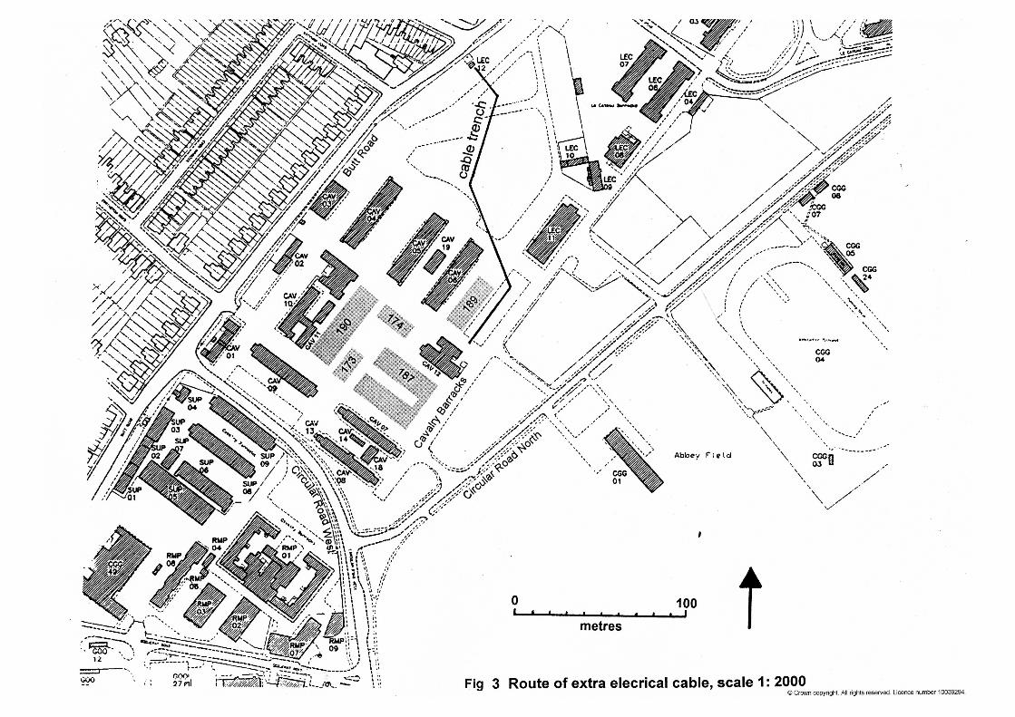
6 Results (Fig 1) 17th July A gas-main trench was monitored to the south-east of new building 189 which had been dug to 600mm depth and 400mm width, partly through a grassed area and partly through tarmac The following soil profile was observed:
Layer 1 or L1 - 0-150/200mm - turf or tarmac and grey silty topsoil containing modern glass, oyster shell and tile flecks. L2 - 150/200mm - light brown sandy silt with frequent pebbles and ceramic drains. Also brick foundations to the demolished stable-block. L3 - 430-600mm - natural clean reddish/brown sand and gravel. 18th July An electricity trench on the south-eastern boundary leading to new building 189 was monitored. This had been dug to 450mm depth and 350mm width through grass. Only the north-eastern stretch was seen before being filled in. At regular intervals were brick foundations to the previous Victorian stable-block. These were set into topsoil and similar soils to L1 and L2 above. 20th July An approximately 1m x 3m rectangle, 220mm deep, was cut into the tarmac on the north side of new building 190. Modern make-up only was observed. 31st July A stretch of elecricity trench and a manhole on the south-western side of the parade ground, leading to new building 187, was monitored. The depth of the manhole was 900mm. Below the tarmac and sub-base was topsoil merging with natural sand at 700mm below ground-level. 10th August A stretch of electricity cable was monitored on the south-eastern side of the site between the canteen (CAV 12) and the south-eastern end of new building 187. Most of the trench was only dug to 400mm although one stretch was dug to 700mm. The only features were brick footings to the demolished 19th-century barrack buildings.

CAT Report 153: An archaeological watching brief at Cavalry Barracks, Colchester, Essex: July-August 2001
3
17th August An extension to the above electricity cable was monitored, which ran north-west, between the two blocks of new building 187. It had only been dug to 400mm and there was nothing of archaeological interest showing. 28th August A length of water and gas pipe was observed running in a north-easterly direction from new building 187 to Cavalry 06. This was dug to between 500 and 700mm depth and revealed tarmac and hogging overlying sandy silt. Nothing of archaeological significance was observed.
7 Discussion The groundworks did not expose any Roman cremations or any other remains of archaeological significance, apart from brick footings to the demolished Victorian barrack-blocks at the south-eastern part of the site (see section 3 above).
8 Archive deposition A copy of this report and site notes will be deposited permanently with Colchester Museum under accession code 2001.125.
9 Acknowledgements The Colchester Archaeological Trust is grateful to Rollalong Limited for commissioning the work on behalf of their clients and for their co-operation, and also to the MoD and Martin Winter, Archaeological Officer for Colchester Borough Council, for their help and co-operation.
10 References Crossan, C, 2001 Archaeological excavations at the Garrison sports
pitch, Circular Road North, Colchester, Essex (Abbey Field), CAT Report 138
Crummy, N, Crummy, P, & Crossan, C, 1993 Excavations of Roman and
later cemeteries and monastic sites in Colchester, 1971-88, Colchester Archaeological Report 9
Douet, J, 1998 British barracks
Kate Orr, September 2001
CAT Report 153: An archaeological watching brief at Cavalry Barracks, Colchester, Essex: July-August 2001
4
© Colchester Archaeological Trust 2001 Distribution list: Rollalong Limited Martin Winter, Archaeological Officer for Colchester Borough Council Essex Heritage Conservation Record, Essex County Council
Colchester Archaeological Trust 12 Lexden Road, Colchester, Essex CO3 3NF
tel.: (01206) 541051 tel./fax: (01206) 500124 email: [email protected]
Checked by: Howard Brooks Date: 25.09.01
athlon c:\reports\cavalry\rep153.doc


Fig 2 Layout of Cavalry Barracks in 1861.
Essex Heritage Conservation Record/
Essex Archaeology and History
Summary sheet
Site name/address: Cavalry Barracks, Circular Road West, Colchester, Essex
Parish: Colchester
District: Colchester Borough
NGR: TL 9906 2432 (c)
Site code: 2001.125
Type of work: Watching brief
Site director/group:
Colchester Archaeological Trust
Date of work: July-August 2001
Size of area investigated:
100m x 80m
Location of finds/curating museum:
Colchester Museum
Funding source:
Developer
Further seasons anticipated? No
Related EHCR nos:
12384, 12386, 13232
Final report: CAT Report 153 and summary in EAH
Periods represented: Modern
Summary of fieldwork results:
The groundworks for new prefabricated buildings and services did not expose any
Roman cremations or any other remains of archaeological significance, apart
from brick footings to the demolished Victorian barrack-blocks at the south-
eastern side of the site.
Previous summaries/reports: None
Author of summary: Kate Orr
Date of summary: September 2001