active incident resource summary · black point, northern region, nevada dof. twenty miles...
TRANSCRIPT
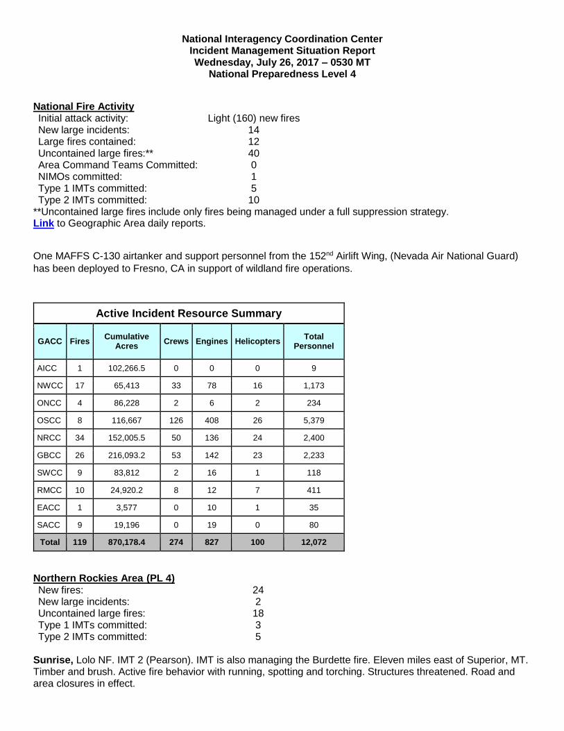
National Interagency Coordination Center Incident Management Situation Report Wednesday, July 26, 2017 – 0530 MT
National Preparedness Level 4
National Fire Activity Initial attack activity: Light (160) new fires New large incidents: 14 Large fires contained: 12 Uncontained large fires:** 40 Area Command Teams Committed: 0 NIMOs committed: 1 Type 1 IMTs committed: 5 Type 2 IMTs committed: 10
**Uncontained large fires include only fires being managed under a full suppression strategy. Link to Geographic Area daily reports.
One MAFFS C-130 airtanker and support personnel from the 152nd Airlift Wing, (Nevada Air National Guard)
has been deployed to Fresno, CA in support of wildland fire operations.
Active Incident Resource Summary
GACC Fires Cumulative
Acres Crews Engines Helicopters
Total Personnel
AICC 1 102,266.5 0 0 0 9
NWCC 17 65,413 33 78 16 1,173
ONCC 4 86,228 2 6 2 234
OSCC 8 116,667 126 408 26 5,379
NRCC 34 152,005.5 50 136 24 2,400
GBCC 26 216,093.2 53 142 23 2,233
SWCC 9 83,812 2 16 1 118
RMCC 10 24,920.2 8 12 7 411
EACC 1 3,577 0 10 1 35
SACC 9 19,196 0 19 0 80
Total 119 870,178.4 274 827 100 12,072
Northern Rockies Area (PL 4) New fires: 24 New large incidents: 2 Uncontained large fires: 18 Type 1 IMTs committed: 3 Type 2 IMTs committed: 5
Sunrise, Lolo NF. IMT 2 (Pearson). IMT is also managing the Burdette fire. Eleven miles east of Superior, MT. Timber and brush. Active fire behavior with running, spotting and torching. Structures threatened. Road and area closures in effect.

Burdette, Lolo NF. Thirteen miles southeast of Tarkio, MT. Timber. Active fire behavior with isolated torching and short-range spotting. Sapphire Complex (3 fires), Lolo NF. IMT 2 (Leach). Fifteen miles southeast of Clinton, MT. Timber. Active fire behavior with torching and short-range spotting. Structures threatened. Evacuations, road, trail and area closures in effect. Lolo Peak, Lolo NF. IMT 1 (Poncin). Nine miles west of Carlton, MT. Timber. Moderate fire behavior with crowning, flanking and spotting. Road, trail and area closures in effect. Buffalo, Miles City District, BLM. IMT 1 (Kurth). IMT is also managing the Stallions incident in the Rocky Mountain Geographic Area. Started on private land 31 miles southwest of Broadus, MT. Timber, brush and grass. Extreme fire behavior with crowning, running and spotting. Structures and sage-grouse habitat threatened. Lodgepole Complex (4 fires), Miles City Field Office, BLM. IMT 2 (Connell). Fifty-two miles northwest of Jordan, MT. Timber, brush and short grass. Active fire behavior with short-range spotting. Structures and sage-grouse habitat threatened. Park Creek, Helena-Lewis and Clark NF. IMT 2 (Hutton). IMT is also managing Arrastra Creek fire. Two miles north of Lincoln, MT. Timber. Active fire behavior with backing, running and group tree torching. Structures threatened. Area closures in effect. Arrastra Creek, Helena NF. Six miles northwest of Lincoln, MT. Timber. Active fire behavior with running, backing and group tree torching. Area closures in effect. Whetstone Ridge, Beaverhead/Deerlodge NF. IMT 1 (Turman). IMT is also managing the Meyers fire. Twenty-five miles southwest of Philipsburg, MT. Timber and heavy logging slash. Active fire behavior with group torching, flanking and backing. Area closures in effect. Meyers, Beaverhead/Deerlodge NF. Twenty-five miles southwest of Philipsburg, MT. Timber and logging slash. Active fire behavior with torching, flanking and backing. Area closures in effect. Powerline, Craig Mountain Area, IDL. Transfer of command from IMT 2 (Almas) back to the local unit will occur today. IMT is also managing the Corral Creek fire. Fifteen miles west of Winchester, ID. Brush and grass. Minimal fire behavior. Area closures in effect. Corral Creek, Craig Mountain Area, IDL. Fifteen miles east of Anatone, ID. Brush and tall grass. Minimal fire behavior. Area closures in effect. Crying, Petroleum County. Fifty miles north of Winnett, MT. Timber, brush and short grass. Minimal fire behavior. Structures threatened. Yooper, Miles City Field Office, BLM. Started on private land 34 miles northwest of Sidney, MT. Timber. No new information. Last report unless new information is received. Microwave, Crow Agency, BIA. Thirty-seven miles southeast of Billings, MT. Brush and tall grass. Minimal fire behavior. * Coffee Pot, Miles City District, BLM. Started on private land 15 miles west of Ekalaka, MT. Brush and tall grass. Extreme fire behavior with running and torching. Structures and sage-grouse habitat threatened. Lookout, Central Land Office, Montana DNR. Seven miles northwest of Sieben, MT. Timber. Minimal fire behavior.
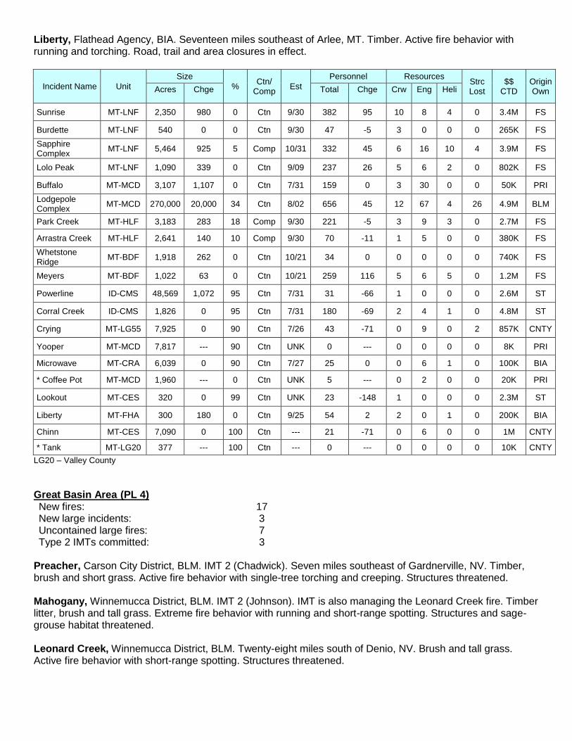
Liberty, Flathead Agency, BIA. Seventeen miles southeast of Arlee, MT. Timber. Active fire behavior with running and torching. Road, trail and area closures in effect.
Incident Name Unit
Size
% Ctn/
Comp Est
Personnel Resources Strc Lost
$$ CTD
Origin Own Acres Chge Total Chge Crw Eng Heli
Sunrise MT-LNF 2,350 980 0 Ctn 9/30 382 95 10 8 4 0 3.4M FS
Burdette MT-LNF 540 0 0 Ctn 9/30 47 -5 3 0 0 0 265K FS
Sapphire Complex
MT-LNF 5,464 925 5 Comp 10/31 332 45 6 16 10 4 3.9M FS
Lolo Peak MT-LNF 1,090 339 0 Ctn 9/09 237 26 5 6 2 0 802K FS
Buffalo MT-MCD 3,107 1,107 0 Ctn 7/31 159 0 3 30 0 0 50K PRI
Lodgepole Complex
MT-MCD 270,000 20,000 34 Ctn 8/02 656 45 12 67 4 26 4.9M BLM
Park Creek MT-HLF 3,183 283 18 Comp 9/30 221 -5 3 9 3 0 2.7M FS
Arrastra Creek MT-HLF 2,641 140 10 Comp 9/30 70 -11 1 5 0 0 380K FS
Whetstone Ridge
MT-BDF 1,918 262 0 Ctn 10/21 34 0 0 0 0 0 740K FS
Meyers MT-BDF 1,022 63 0 Ctn 10/21 259 116 5 6 5 0 1.2M FS
Powerline ID-CMS 48,569 1,072 95 Ctn 7/31 31 -66 1 0 0 0 2.6M ST
Corral Creek ID-CMS 1,826 0 95 Ctn 7/31 180 -69 2 4 1 0 4.8M ST
Crying MT-LG55 7,925 0 90 Ctn 7/26 43 -71 0 9 0 2 857K CNTY
Yooper MT-MCD 7,817 --- 90 Ctn UNK 0 --- 0 0 0 0 8K PRI
Microwave MT-CRA 6,039 0 90 Ctn 7/27 25 0 0 6 1 0 100K BIA
* Coffee Pot MT-MCD 1,960 --- 0 Ctn UNK 5 --- 0 2 0 0 20K PRI
Lookout MT-CES 320 0 99 Ctn UNK 23 -148 1 0 0 0 2.3M ST
Liberty MT-FHA 300 180 0 Ctn 9/25 54 2 2 0 1 0 200K BIA
Chinn MT-CES 7,090 0 100 Ctn --- 21 -71 0 6 0 0 1M CNTY
* Tank MT-LG20 377 --- 100 Ctn --- 0 --- 0 0 0 0 10K CNTY
LG20 – Valley County
Great Basin Area (PL 4) New fires: 17 New large incidents: 3 Uncontained large fires: 7 Type 2 IMTs committed: 3
Preacher, Carson City District, BLM. IMT 2 (Chadwick). Seven miles southeast of Gardnerville, NV. Timber, brush and short grass. Active fire behavior with single-tree torching and creeping. Structures threatened. Mahogany, Winnemucca District, BLM. IMT 2 (Johnson). IMT is also managing the Leonard Creek fire. Timber litter, brush and tall grass. Extreme fire behavior with running and short-range spotting. Structures and sage-grouse habitat threatened. Leonard Creek, Winnemucca District, BLM. Twenty-eight miles south of Denio, NV. Brush and tall grass. Active fire behavior with short-range spotting. Structures threatened.
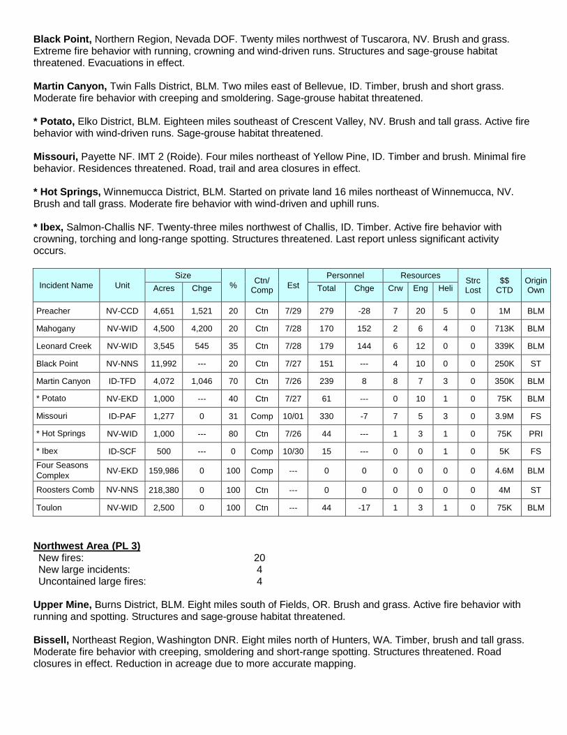
Black Point, Northern Region, Nevada DOF. Twenty miles northwest of Tuscarora, NV. Brush and grass. Extreme fire behavior with running, crowning and wind-driven runs. Structures and sage-grouse habitat threatened. Evacuations in effect. Martin Canyon, Twin Falls District, BLM. Two miles east of Bellevue, ID. Timber, brush and short grass. Moderate fire behavior with creeping and smoldering. Sage-grouse habitat threatened. * Potato, Elko District, BLM. Eighteen miles southeast of Crescent Valley, NV. Brush and tall grass. Active fire behavior with wind-driven runs. Sage-grouse habitat threatened. Missouri, Payette NF. IMT 2 (Roide). Four miles northeast of Yellow Pine, ID. Timber and brush. Minimal fire behavior. Residences threatened. Road, trail and area closures in effect. * Hot Springs, Winnemucca District, BLM. Started on private land 16 miles northeast of Winnemucca, NV. Brush and tall grass. Moderate fire behavior with wind-driven and uphill runs. * Ibex, Salmon-Challis NF. Twenty-three miles northwest of Challis, ID. Timber. Active fire behavior with crowning, torching and long-range spotting. Structures threatened. Last report unless significant activity occurs.
Incident Name Unit
Size
% Ctn/
Comp Est
Personnel Resources Strc Lost
$$ CTD
Origin Own Acres Chge Total Chge Crw Eng Heli
Preacher NV-CCD 4,651 1,521 20 Ctn 7/29 279 -28 7 20 5 0 1M BLM
Mahogany NV-WID 4,500 4,200 20 Ctn 7/28 170 152 2 6 4 0 713K BLM
Leonard Creek NV-WID 3,545 545 35 Ctn 7/28 179 144 6 12 0 0 339K BLM
Black Point NV-NNS 11,992 --- 20 Ctn 7/27 151 --- 4 10 0 0 250K ST
Martin Canyon ID-TFD 4,072 1,046 70 Ctn 7/26 239 8 8 7 3 0 350K BLM
* Potato NV-EKD 1,000 --- 40 Ctn 7/27 61 --- 0 10 1 0 75K BLM
Missouri ID-PAF 1,277 0 31 Comp 10/01 330 -7 7 5 3 0 3.9M FS
* Hot Springs NV-WID 1,000 --- 80 Ctn 7/26 44 --- 1 3 1 0 75K PRI
* Ibex ID-SCF 500 --- 0 Comp 10/30 15 --- 0 0 1 0 5K FS
Four Seasons
Complex NV-EKD 159,986 0 100 Comp --- 0 0 0 0 0 0 4.6M BLM
Roosters Comb NV-NNS 218,380 0 100 Ctn --- 0 0 0 0 0 0 4M ST
Toulon NV-WID 2,500 0 100 Ctn --- 44 -17 1 3 1 0 75K BLM
Northwest Area (PL 3) New fires: 20 New large incidents: 4 Uncontained large fires: 4
Upper Mine, Burns District, BLM. Eight miles south of Fields, OR. Brush and grass. Active fire behavior with running and spotting. Structures and sage-grouse habitat threatened. Bissell, Northeast Region, Washington DNR. Eight miles north of Hunters, WA. Timber, brush and tall grass. Moderate fire behavior with creeping, smoldering and short-range spotting. Structures threatened. Road closures in effect. Reduction in acreage due to more accurate mapping.

Chetco Bar, Rogue River-Siskiyou NF. NIMO (Housemann). Previously reported incident. Sixteen miles east of Selma, OR. Timber and brush. No new information. * Emerson, Ochoco NF. Four miles northeast of Madras, OR. Brush and tall grass. Active fire behavior with running and spotting. Structures threatened. Road and area closures in effect. * Crane, Lake Unit, Oregon DOF. Four miles southeast of Lakeview, OR. Timber. Active fire behavior with running, spotting and torching. Structures threatened.
Incident Name Unit
Size
% Ctn/
Comp Est
Personnel Resources Strc Lost
$$ CTD
Origin Own Acres Chge Total Chge Crw Eng Heli
Upper Mine OR-BUD 4,800 2,300 0 Ctn 7/31 187 73 4 19 2 3 450K BLM
Bissell WA-NES 377 -34 25 Ctn 7/28 132 -18 5 10 0 0 425K ST
Chetco Bar OR-RSF 1,418 915 0 Comp 10/15 138 51 7 0 1 0 610K FS
* Emerson OR-OCF 2,000 --- 0 Ctn 7/29 41 --- 1 9 0 0 250K FS
* Crane OR-982S 570 --- 0 Ctn 7/29 62 --- 1 3 4 0 950K ST
400 WA-SES 24,650 0 100 Ctn --- 0 0 0 0 0 0 1.3M DOD
* Duck OR-VAD 420 0 100 Ctn --- 14 -64 0 4 0 0 250K BLM
* Bowden OR-VAD 17,773 --- 100 Ctn --- 117 --- 3 15 2 0 300K BLM
Sheep WA-SES 1,771 0 100 Ctn --- 79 -72 2 5 0 0 203K ST
SES – Southeast Region, Washington DNR
Southern California Area (PL 3) New fires: 14 New large incidents: 0 Uncontained large fires: 2 Type 1 IMTs committed: 2
Detwiler, Merced-Mariposa Unit, Cal Fire. Cal Fire IMT 1 (Derum). Fifteen miles northwest of Mariposa, CA. Brush and tall grass. Moderate fire behavior with backing. Structures threatened. Evacuations and road closures in effect. Whittier, Los Padres NF. Transfer of command from IMT 1 (von Tillow) back to the local unit will occur today. Eleven miles northeast of Goleta, CA. Chaparral and brush. Minimal fire behavior. Road, area and trail closures in effect.
Incident Name Unit
Size
% Ctn/
Comp Est
Personnel Resources Strc Lost
$$ CTD
Origin Own Acres Chge Total Chge Crw Eng Heli
Detwiler CA-MMU 80,000 1,100 65 Ctn 8/05 4,495 -518 105 361 19 131 48.9M ST
Whittier CA-LPF 18,430 0 87 Ctn 8/30 394 -117 7 11 5 46 36.6M FS
Northern California Area (PL 3) New fires: 65 New large incidents: 1 Uncontained large fires: 1 Type 2 IMTs committed: 1
* Modoc July Complex, Modoc NF. IMT 2 (Young). Twenty miles northeast of Newell, CA. Brush. No further information received.

Incident Name Unit
Size
% Ctn/
Comp Est
Personnel Resources Strc Lost
$$ CTD
Origin Own Acres Chge Total Chge Crw Eng Heli
* Modoc July Complex
CA-MDF 702 --- 15 Comp 8/01 4 --- 0 0 0 0 1K FS
Marble CA-SRF 319 0 100 Ctn --- 180 -175 2 5 2 0 2.3M FS
SRF – Six Rivers NF
Rocky Mountain Area (PL 2) New fires: 9 New large incidents: 1 Uncontained large fires: 4 Type 2 IMTs committed: 1
June, Shoshone NF. Transfer of command from IMT 2 (Greer) back to the local unit will occur tomorrow. Thirty-four miles west of Cody, WY. Timber. Minimal fire behavior. Structures threatened. Trail and area closures in effect. Reduction in acreage due to more accurate mapping. * Stallions, Campbell County. Fifteen miles north of Recluse, WY. Timber, brush and grass. Extreme fire behavior with running and torching. Keystone, Medicine Bow NF. Thirty-five miles southwest of Laramie, WY. Timber and medium logging slash. Minimal fire behavior. Structures threatened. Road, area and trail closures in effect. Gutzler, White River NF. Thirteen miles southwest of Kremmling, CO. Timber and brush. Minimal fire behavior. Residences threatened.
Incident Name Unit
Size
% Ctn/
Comp Est
Personnel Resources Strc Lost
$$ CTD
Origin Own Acres Chge Total Chge Crw Eng Heli
June WY-SHF 1,618 -320 70 Ctn 9/30 203 -73 3 2 4 0 2.7M FS
* Stallions WY-CMX 1,110 --- 50 Ctn 7/28 0 --- 0 0 0 0 1K CNTY
Keystone WY-MBF 2,527 7 75 Ctn 7/31 82 -4 1 4 2 1 13.2M FS
Gutzler CO-WRF 974 0 50 Ctn 9/01 7 -3 0 0 0 0 1.6M FS
Wind Mill Draw WY-CMX 447 21 100 Ctn --- 0 -10 0 0 0 0 1K CNTY
Southern Area (PL 1) New fires: 6 New large incidents: 3 Uncontained large fires: 4
Aeromotor, Texas A&M Forest Service. Started on private land seven miles north of Paducah, TX. Brush. Active fire behavior with running. Gibson Ranch, Texas A&M Forest Service. Started on private land six miles east of Chalk, TX. Brush and tall grass. Active fire behavior with single-tree torching and creeping. Residences threatened. * County Road 20, Texas A&M Forest Service. Started on private land nine miles northeast of Pringle, TX. Brush and tall grass. Minimal fire behavior. * Flat Top, Oklahoma Forestry Services. Sixteen miles southeast of Lone Wolf, OK. Timber, brush and grass. Active fire behavior with backing, flanking and uphill runs.
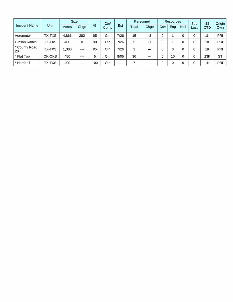
Incident Name Unit
Size
% Ctn/
Comp Est
Personnel Resources Strc Lost
$$ CTD
Origin Own Acres Chge Total Chge Crw Eng Heli
Aeromotor TX-TXS 4,866 282 95 Ctn 7/26 15 -3 0 1 0 0 1K PRI
Gibson Ranch TX-TXS 400 0 90 Ctn 7/26 5 -1 0 1 0 0 1K PRI
* County Road 20
TX-TXS 1,300 --- 95 Ctn 7/26 3 --- 0 0 0 0 1K PRI
* Flat Top OK-OKS 450 --- 5 Ctn 8/05 30 --- 0 10 0 0 23K ST
* Hardball TX-TXS 400 --- 100 Ctn --- 7 --- 0 0 0 0 1K PRI

Fires and Acres Yesterday (by Protection):
Area BIA BLM FWS NPS ST/OT USFS TOTAL
Alaska Area FIRES 0 0 0 0 0 0 0
ACRES 0 2,667 0 0 6 0 2,673
Northwest Area FIRES 3 4 0 0 7 6 20
ACRES 21 1 0 0 5 10 37
Northern California Area FIRES 0 0 0 0 32 33 65
ACRES 0 0 0 0 60 15 75
Southern California Area FIRES 0 0 1 0 11 2 14
ACRES 0 0 0 0 453 0 453
Northern Rockies Area FIRES 1 4 0 0 14 5 24
ACRES 1 4,741 0 0 7 2,966 7,715
Great Basin Area FIRES 0 10 0 0 4 3 17
ACRES 0 6,527 0 0 4 475 7,006
Southwest Area FIRES 0 0 0 0 2 3 5
ACRES 0 0 0 0 0 208 208
Rocky Mountain Area FIRES 1 0 0 0 6 2 9
ACRES 0 0 0 0 97 10 107
Eastern Area FIRES 0 0 0 0 0 0 0
ACRES 0 0 0 0 0 0 0
Southern Area FIRES 0 0 0 0 6 0 6
ACRES 0 0 0 0 1,506 0 1,506
TOTAL FIRES: 5 18 1 0 82 54 160
TOTAL ACRES: 22 13,936 0 0 2,138 3,684 19,780

Fires and Acres Year-to-Date (by Protection):
Area BIA BLM FWS NPS ST/OT USFS TOTAL
Alaska Area FIRES 0 159 0 0 151 11 321
ACRES 0 466,839 0 0 81,234 1 548,074
Northwest Area FIRES 131 101 23 7 573 328 1,163
ACRES 3,871 52,866 773 1 17,362 4,950 79,823
Northern California Area FIRES 31 9 2 5 1,438 205 1,690
ACRES 28 13,124 70 5 17,260 3,151 33,638
Southern California Area FIRES 155 43 2 13 2,073 221 2,507
ACRES 186 619 0 6 117,900 41,961 160,672
Northern Rockies Area FIRES 535 68 12 4 660 314 1,593
ACRES 16,402 265,073 420 24 86,039 25,831 393,789
Great Basin Area FIRES 21 593 4 30 543 192 1,383
ACRES 289 838,581 2 38 350,812 71,325 1,261,047
Southwest Area FIRES 592 200 10 32 634 729 2,197
ACRES 45,678 22,753 191 1,341 113,607 318,829 502,399
Rocky Mountain Area FIRES 534 214 7 13 577 261 1,606
ACRES 2,757 35,949 202 328 479,853 7,071 526,160
Eastern Area FIRES 343 0 13 14 3,085 278 3,733
ACRES 696 0 19 129 16,498 3,110 20,452
Southern Area FIRES 256 8 42 26 19,639 352 20,323
ACRES 60,251 36 151,442 53,054 1,311,947 25,698 1,602,428
TOTAL FIRES: 2,598 1,395 115 144 29,373 2,891 36,516
TOTAL ACRES: 130,158 1,695,840 153,119 54,926 2,592,512 501,927 5,128,482
Ten Year Average Fires (2007 – 2016 as of today) 41,244
Ten Year Average Acres (2007 – 2016 as of today) 3,556,619
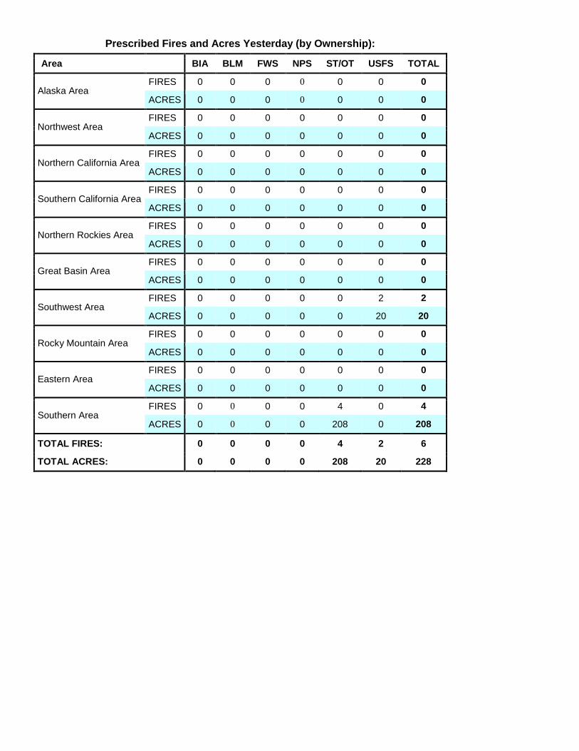
Prescribed Fires and Acres Yesterday (by Ownership):
Area BIA BLM FWS NPS ST/OT USFS TOTAL
Alaska Area FIRES 0 0 0 0 0 0 0
ACRES 0 0 0 0 0 0 0
Northwest Area FIRES 0 0 0 0 0 0 0
ACRES 0 0 0 0 0 0 0
Northern California Area FIRES 0 0 0 0 0 0 0
ACRES 0 0 0 0 0 0 0
Southern California Area FIRES 0 0 0 0 0 0 0
ACRES 0 0 0 0 0 0 0
Northern Rockies Area FIRES 0 0 0 0 0 0 0
ACRES 0 0 0 0 0 0 0
Great Basin Area FIRES 0 0 0 0 0 0 0
ACRES 0 0 0 0 0 0 0
Southwest Area FIRES 0 0 0 0 0 2 2
ACRES 0 0 0 0 0 20 20
Rocky Mountain Area FIRES 0 0 0 0 0 0 0
ACRES 0 0 0 0 0 0 0
Eastern Area FIRES 0 0 0 0 0 0 0
ACRES 0 0 0 0 0 0 0
Southern Area FIRES 0 0 0 0 4 0 4
ACRES 0 0 0 0 208 0 208
TOTAL FIRES: 0 0 0 0 4 2 6
TOTAL ACRES: 0 0 0 0 208 20 228
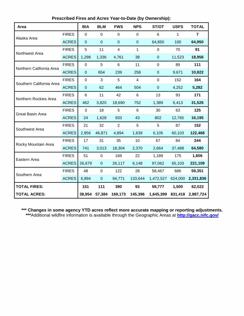
Prescribed Fires and Acres Year-to-Date (by Ownership):
Area BIA BLM FWS NPS ST/OT USFS TOTAL
Alaska Area FIRES 0 0 0 0 6 1 7
ACRES 0 0 0 0 64,850 100 64,950
Northwest Area FIRES 5 11 4 1 0 70 91
ACRES 1,298 1,336 4,761 38 0 11,523 18,956
Northern California Area FIRES 0 5 6 11 0 89 111
ACRES 0 654 239 258 0 9,671 10,822
Southern California Area FIRES 0 3 5 4 0 152 164
ACRES 0 62 464 504 0 4,252 5,282
Northern Rockies Area FIRES 6 11 42 6 13 93 171
ACRES 462 3,820 18,690 752 1,389 6,413 31,526
Great Basin Area FIRES 3 18 5 6 30 63 125
ACRES 24 1,628 933 43 802 12,765 16,195
Southwest Area FIRES 21 32 2 5 5 87 152
ACRES 2,856 46,871 4,894 1,639 6,105 60,103 122,468
Rocky Mountain Area FIRES 17 31 35 10 67 84 244
ACRES 741 3,013 18,304 2,370 2,664 37,488 64,580
Eastern Area FIRES 51 0 169 22 1,189 175 1,606
ACRES 26,679 0 26,117 6,148 97,062 65,103 221,109
Southern Area FIRES 48 0 122 28 58,467 686 59,351
ACRES 6,894 0 94,771 133,644 1,472,527 624,000 2,331,836
TOTAL FIRES: 151 111 390 93 59,777 1,500 62,022
TOTAL ACRES: 38,954 57,384 169,173 145,396 1,645,399 831,418 2,887,724
*** Changes in some agency YTD acres reflect more accurate mapping or reporting adjustments. ***Additional wildfire information is available through the Geographic Areas at http://gacc.nifc.gov/

Canada Fires and Hectares
PROVINCES FIRES
YESTERDAY HECTARES
YESTERDAY FIRES YEAR-
TO-DATE HECTARES
YEAR-TO-DATE
BRITISH COLUMBIA 10 2,279 761 375,443
YUKON TERRITORY 0 0 87 316,173
ALBERTA 3 263 803 3,525
NORTHWEST TERRITORY 3 1,168 136 179,487
SASKATCHEWAN 3 199 144 2,276
MANITOBA 6 11 140 26,153
ONTARIO 7 36 178 44,380
QUEBEC 3 7 177 33,568
NEWFOUNDLAND 2 2 55 689
NEW BRUNSWICK 4 4 82 38
NOVA SCOTIA 0 0 144 722
PRINCE EDWARD ISLAND 0 0 4 7
NATIONAL PARKS 1 0 109 40,433
TOTALS 42 3,968 2,820 1,022,895
* 1 Hectare = 2.47 Acres
Predictive Services Discussion: The high pressure ridge over the southern Great Plains will begin to slowly
strengthen and migrate westward toward its former position over the Four Corners. As it does so, the scattered
wet convection will continue to redevelop over the Great Basin, Northern California, Oregon, and the Northern
Rockies. Some moisture could drift over the Sierra Crest and into Central and Southern California but remain
anchored over the mountains. Temperatures across the West will be slightly above normal. Significant winds
are not expected today in most areas unless they are associated with thunderstorms outflows.
http://www.predictiveservices.nifc.gov/outlooks/outlooks.htm

HAZARD TREE - RISK MANAGEMENT Felling Safety Category
Environment:
Existing winds and forecast
Night operations
Steep slopes
Diseased or bug-kill areas
Number, density, and height of hazard trees
Anticipated burn-down time
Potential for domino effect to surrounding trees
Maintain situational awareness and continually reassess hazards
Hazard Tree Indicators:
Trees burning for any period of time
High risk tree species (rot and shallow roots)
Numerous downed trees
Dead, broken, or burning tops and limbs overhead
Accumulation of downed limbs
Absence of needles, bark or limbs
Leaning or hung-up
Note: In addition to suppression and mop-up operations, assess, control, and monitor hazard trees
along roads and when selecting break areas or campsites.
Hazard Control:
Eliminate the hazards with qualified sawyers, blasters/explosives, or heavy
equipment
Avoid hazards by designating “No Work Zones” (NWZ) – (flag, sign, and map)
Modify suppression tactics or fireline location to avoid extreme/high risk rated area
Post lookouts to help maintain secure area
Fire proof potential hazard trees to prevent ignition
Initiate road/traffic control and area closure
Keep clear of bucket drops near trees/snags
Establish trigger points for reposition to secure areas in response to high winds
References:
Hazard Tree Safety Web Page
Have an idea? Have feedback? Share it. EMAIL | Facebook | MAIL: 6 Minutes for Safety Subcommittee • 3833 S. Development Ave • Boise, ID 83705 | FAX: 208-387-5250