action research studies on climate change impacts in the...
TRANSCRIPT
Action Research studies on climate change impacts in the Haor Areasand Improving Flash Flood Forecasting
A.K.M. Saiful Islam
National Startup Workshop on Climate Adaptation and Livelihood Improvement Protection (CALIP)
29-31 January 2015, Dhaka, Bangladesh
Institute of Water and Flood Management Bangladesh University of Engineering and Technology (BUET)
Professor
Institute of Water and Flood Management - Bangladesh University of Engineering and Technology (BUET)
Outline
• Climate Change modeling and scenarios for the Haor Areas of Bangladesh
• Possible Impact of the Extreme Climate on the hydrological cycles of the Haor Regions
• Capacity building of the Flash Flood Forecasting of the Haor Regions of Bangladesh through action research and training.
• Overview of some of the on-going climate research at IWFM, BUET.

Institute of Water and Flood Management - Bangladesh University of Engineering and Technology (BUET)
Green House Gases and Global Warming leading to Climate Change
• CO2 and some other minor gases absorb some of the thermal radiation leaving the surface of the earth.
• Emit radiation from much higher and colder levels out to space. These radiatively active gases are known as greenhouse gases.
• They act as a partial blanket for the thermal radiation from the surface which enables it to be substantially warmer than it would otherwise be, analogous to the effect of a greenhouse.
Institute of Water and Flood Management - Bangladesh University of Engineering and Technology (BUET)
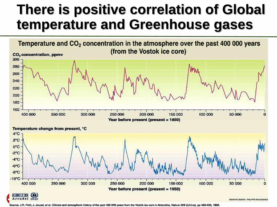
There is positive correlation of Global temperature and Greenhouse gases
Institute of Water and Flood Management - Bangladesh University of Engineering and Technology (BUET)
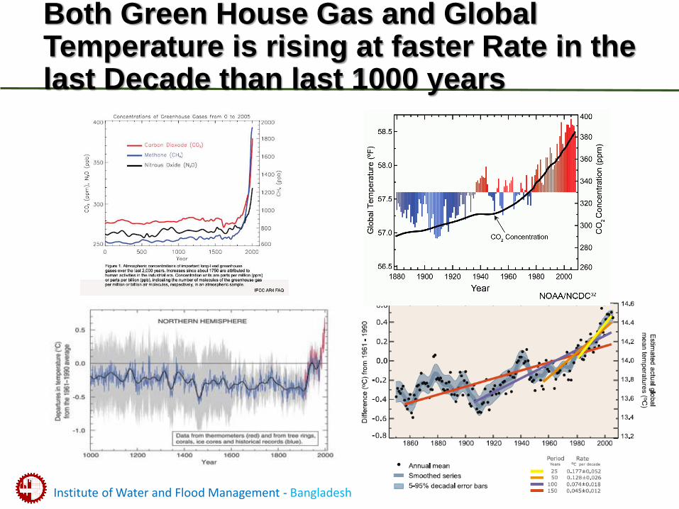
Both Green House Gas and Global Temperature is rising at faster Rate in the last Decade than last 1000 years
Institute of Water and Flood Management - Bangladesh University of Engineering and Technology (BUET)
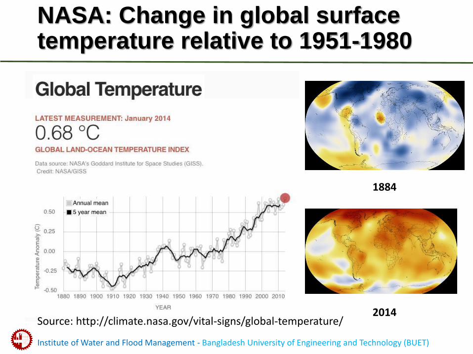
NASA: Change in global surface temperature relative to 1951-1980
1884
2014Source: http://climate.nasa.gov/vital-signs/global-temperature/
Institute of Water and Flood Management - Bangladesh University of Engineering and Technology (BUET)
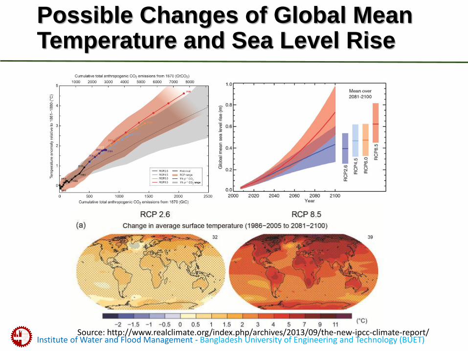
Possible Changes of Global Mean Temperature and Sea Level Rise
Source: http://www.realclimate.org/index.php/archives/2013/09/the-new-ipcc-climate-report/
Institute of Water and Flood Management - Bangladesh University of Engineering and Technology (BUET)
Climate Change Impact for Bangladesh
• Increase of intensity and duration of natural disasterssuch as floods, Cyclones and Storm Surges.
• Increase of moisture stress (droughts) due to erratic precipitation
• Salinity intrusion due to Sea Level Rise
• Inundation due to sea level rise leading towards “Climate Refugees”
• Effect on health and livelihood of coastal people.
• Effect on Bio-diversity, Ecology & Sundarbans.
• Hampered Food Security & Social Security.
Institute of Water and Flood Management - Bangladesh University of Engineering and Technology (BUET)
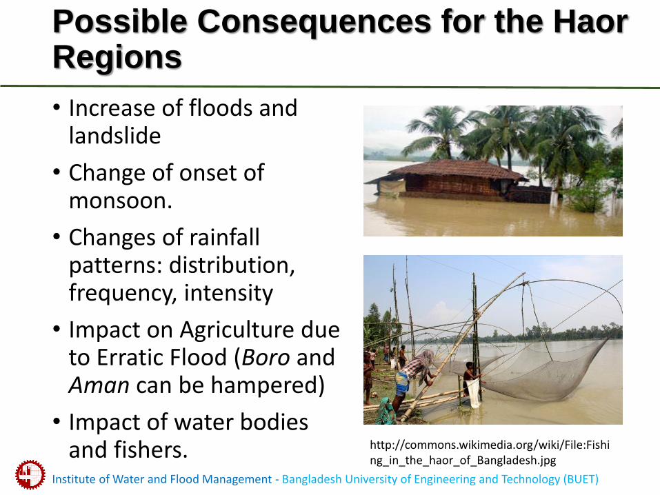
Possible Consequences for the Haor Regions
• Increase of floods and landslide
• Change of onset of monsoon.
• Changes of rainfall patterns: distribution, frequency, intensity
• Impact on Agriculture due to Erratic Flood (Boro and Aman can be hampered)
• Impact of water bodies and fishers. http://commons.wikimedia.org/wiki/File:Fishi
ng_in_the_haor_of_Bangladesh.jpg
Institute of Water and Flood Management - Bangladesh University of Engineering and Technology (BUET)
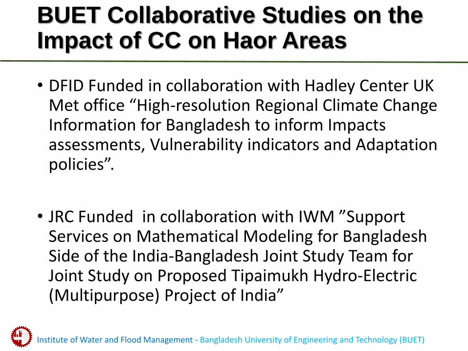
BUET Collaborative Studies on the Impact of CC on Haor Areas
• DFID Funded in collaboration with Hadley Center UK Met office “High-resolution Regional Climate Change Information for Bangladesh to inform Impacts assessments, Vulnerability indicators and Adaptation policies”.
• JRC Funded in collaboration with IWM ”Support Services on Mathematical Modeling for Bangladesh Side of the India-Bangladesh Joint Study Team for Joint Study on Proposed Tipaimukh Hydro-Electric (Multipurpose) Project of India”
Institute of Water and Flood Management - Bangladesh University of Engineering and Technology (BUET)
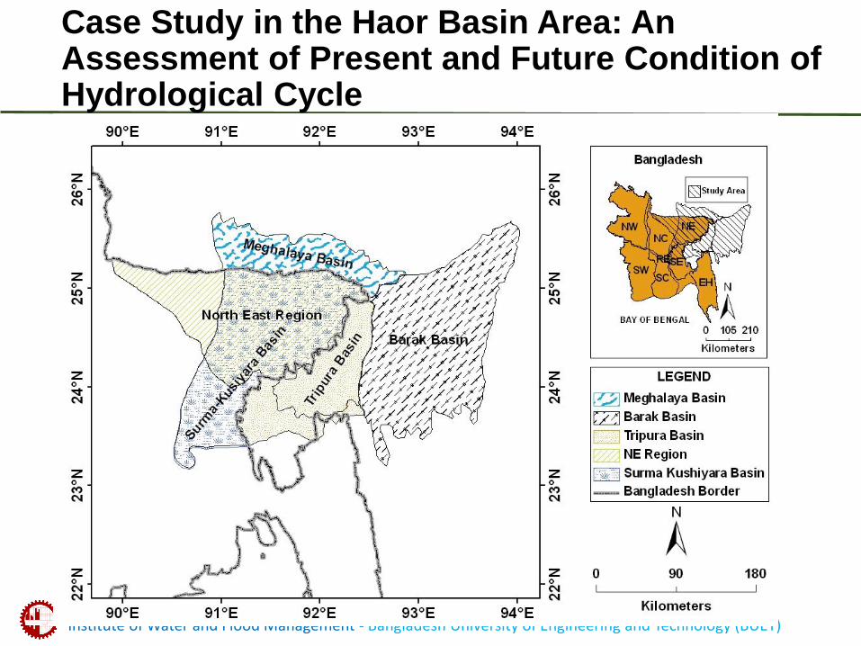
Case Study in the Haor Basin Area: An Assessment of Present and Future Condition of Hydrological Cycle
Institute of Water and Flood Management - Bangladesh University of Engineering and Technology (BUET)
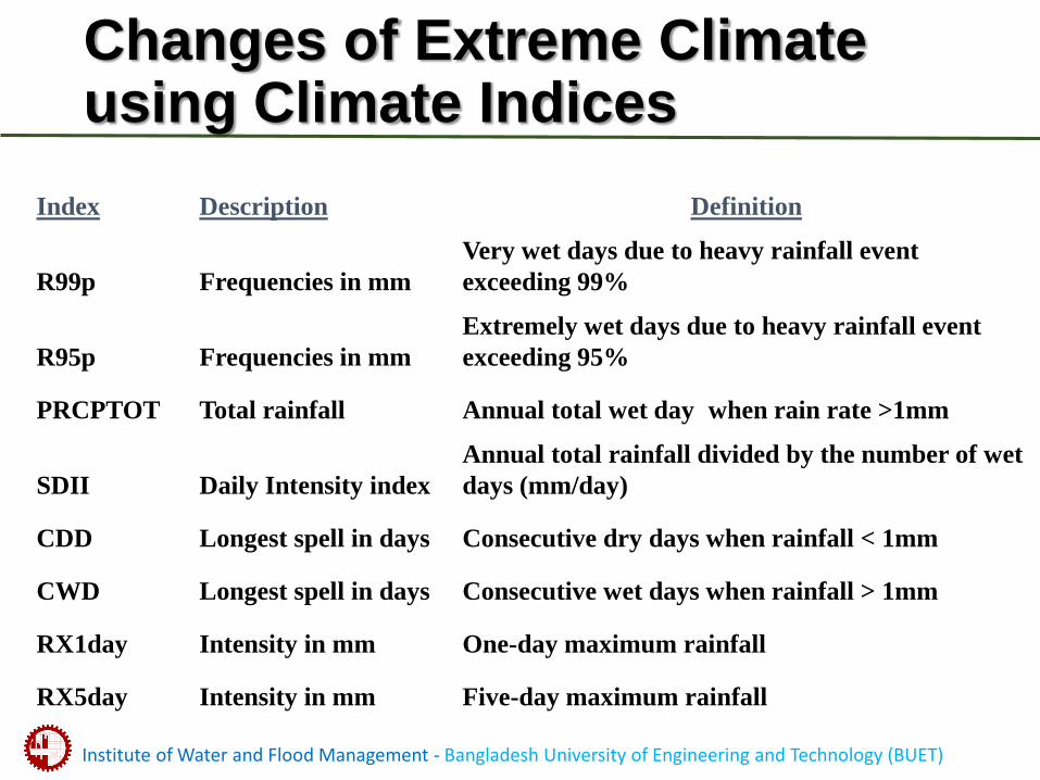
Index Description Definition
R99p Frequencies in mm
Very wet days due to heavy rainfall event
exceeding 99%
R95p Frequencies in mm
Extremely wet days due to heavy rainfall event
exceeding 95%
PRCPTOT Total rainfall Annual total wet day when rain rate >1mm
SDII Daily Intensity index
Annual total rainfall divided by the number of wet
days (mm/day)
CDD Longest spell in days Consecutive dry days when rainfall < 1mm
CWD Longest spell in days Consecutive wet days when rainfall > 1mm
RX1day Intensity in mm One-day maximum rainfall
RX5day Intensity in mm Five-day maximum rainfall
Changes of Extreme Climate using Climate Indices
Institute of Water and Flood Management - Bangladesh University of Engineering and Technology (BUET)
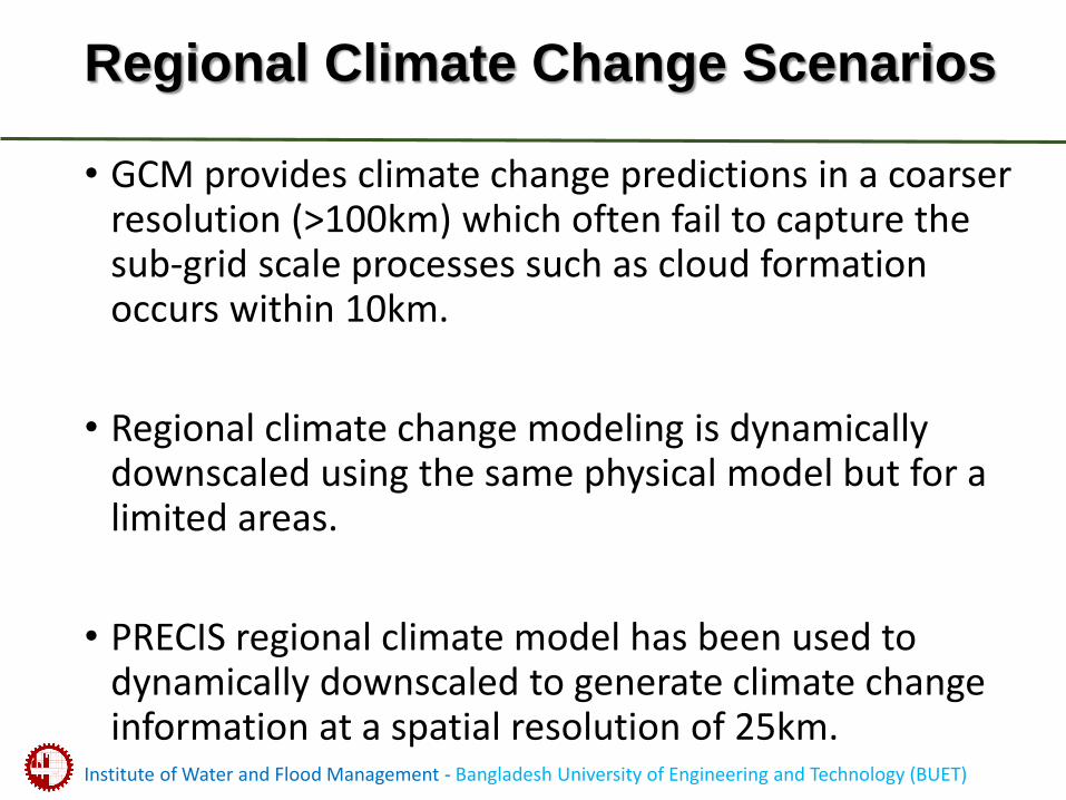
Regional Climate Change Scenarios
• GCM provides climate change predictions in a coarser resolution (>100km) which often fail to capture the sub-grid scale processes such as cloud formation occurs within 10km.
• Regional climate change modeling is dynamically downscaled using the same physical model but for a limited areas.
• PRECIS regional climate model has been used to dynamically downscaled to generate climate change information at a spatial resolution of 25km.
Institute of Water and Flood Management - Bangladesh University of Engineering and Technology (BUET)
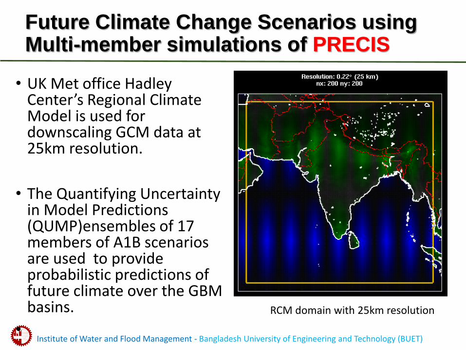
Future Climate Change Scenarios using Multi-member simulations of PRECIS
• UK Met office Hadley Center’s Regional Climate Model is used for downscaling GCM data at 25km resolution.
• The Quantifying Uncertainty in Model Predictions (QUMP)ensembles of 17 members of A1B scenarios are used to provide probabilistic predictions of future climate over the GBM basins.
•
RCM domain with 25km resolution
Institute of Water and Flood Management - Bangladesh University of Engineering and Technology (BUET)
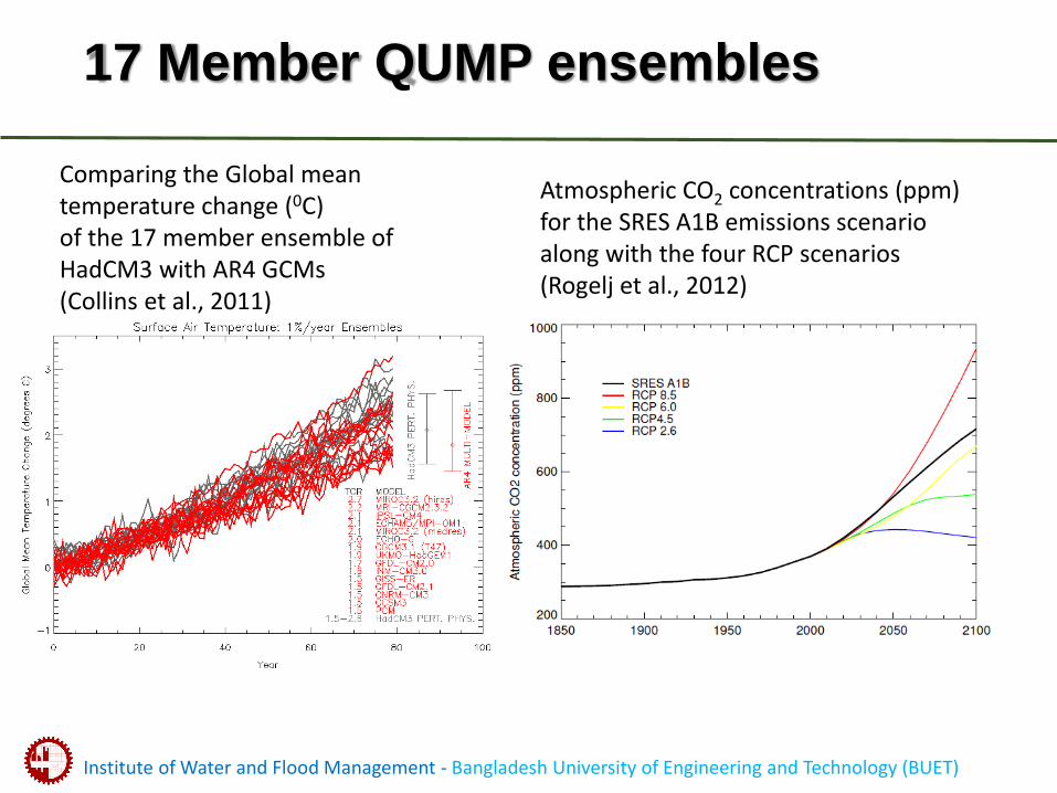
17 Member QUMP ensembles
Atmospheric CO2 concentrations (ppm) for the SRES A1B emissions scenario along with the four RCP scenarios (Rogelj et al., 2012)
Comparing the Global mean temperature change (0C) of the 17 member ensemble of HadCM3 with AR4 GCMs (Collins et al., 2011)
Institute of Water and Flood Management - Bangladesh University of Engineering and Technology (BUET)
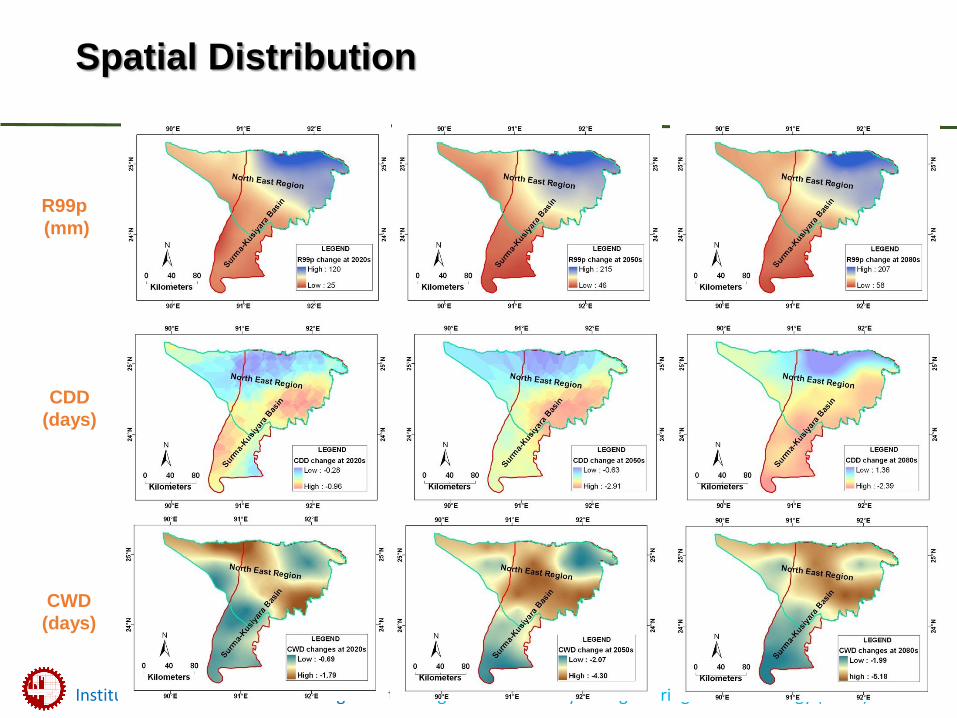
R99p
(mm)
@ 2050s @ 2080s
CDD
(days)
CWD
(days)
@ 2020s
…..changes from the baselineSpatial Distribution
Institute of Water and Flood Management - Bangladesh University of Engineering and Technology (BUET)
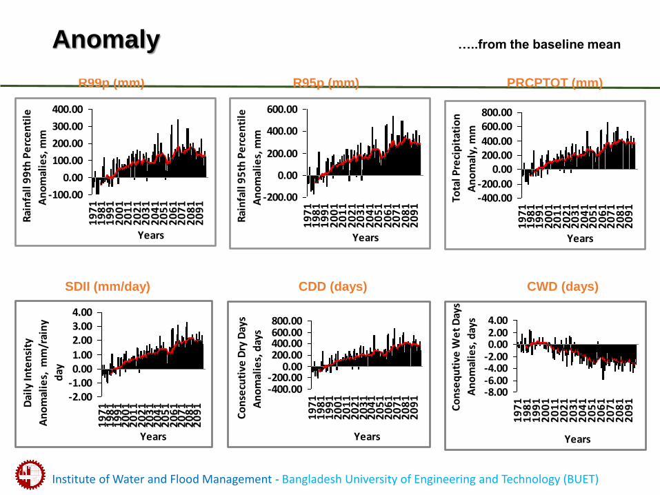
R99p (mm)
CDD (days)
Anomaly
CWD (days)
…..from the baseline mean
-100.00
0.00
100.00
200.00
300.00
400.00
19
71
19
81
19
91
20
01
20
11
20
21
20
31
20
41
20
51
20
61
20
71
20
81
20
91
Years
Rai
nfa
ll 9
9th
Pe
rce
nti
le
An
om
alie
s, m
m
-200.00
0.00
200.00
400.00
600.00
19
71
19
81
19
91
20
01
20
11
20
21
20
31
20
41
20
51
20
61
20
71
20
81
20
91
Years R
ain
fall
95
th P
erc
en
tile
An
om
alie
s, m
m
-400.00-200.00
0.00200.00400.00
600.00800.00
19
71
19
81
19
91
20
01
20
11
20
21
20
31
20
41
20
51
20
61
20
71
20
81
20
91
Years
To
tal P
reci
pit
atio
n
An
om
aly,
mm
-2.00-1.000.001.00
2.003.004.00
19
71
19
81
19
91
20
01
20
11
20
21
20
31
20
41
20
51
20
61
20
71
20
81
20
91
Years
Dai
ly In
ten
sity
An
om
alie
s, m
m/r
ain
y
day
-400.00-200.00
0.00200.00400.00600.00800.00
19
71
19
81
19
91
20
01
20
11
20
21
20
31
20
41
20
51
20
61
20
71
20
81
20
91
Years
Co
nse
cuti
ve D
ry D
ays
An
om
alie
s, d
ays
-8.00-6.00-4.00-2.000.002.004.00
19
71
19
81
19
91
20
01
20
11
20
21
20
31
20
41
20
51
20
61
20
71
20
81
20
91
Years
Co
nse
qu
tive
We
t D
ays
An
om
alie
s, d
ays
R95p (mm) PRCPTOT (mm)
SDII (mm/day)
Institute of Water and Flood Management - Bangladesh University of Engineering and Technology (BUET)
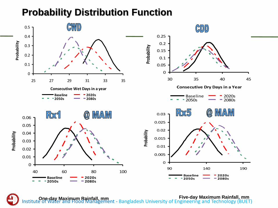
0
0.05
0.1
0.15
0.2
0.25
30 35 40 45
Consecutive Dry Days in a Year
Prob
abili
ty
Baseline 2020s2050s 2080s
0
0.005
0.01
0.015
0.02
0.025
0.03
90 140 190
Prob
abili
ty
Baseline 2020s2050s 2080s
0
0.01
0.02
0.03
0.04
0.05
0.06
40 60 80 100
Prob
abili
ty
Baseline 2020s2050s 2080s
0
0.1
0.2
0.3
0.4
0.5
25 27 29 31 33 35
Consecutive Wet Days in a year
Pro
bab
ilit
y
Baseline 2020s2050s 2080s
Probability Distribution Function
One-day Maximum Rainfall, mm Five-day Maximum Rainfall, mm
Institute of Water and Flood Management - Bangladesh University of Engineering and Technology (BUET)
Conclusion
• Significant increase in magnitudes and variability both rainfall and temperature during premonsoon, monsoon and annual rainfall.
• Highest variability in both rainfall and temperature during the premonsoon
• Premonsoon rainfall is expected to be 0.42 - 75% more in 2080s.
• The rainy days are projected to be less frequent and more intense where the deeply flooded haors are situated. Projection on continuous decrease in anomaly of CWD and continuous increase in anomaly of R99p also support the increasing tendency of SDII.
• Significant increase in both RX1 and RX5 during the premonsoonseason shows a tendency towards more occurrences of flash floods with high volumes.
• Except CDD and CWD, all indices show more rightward shifting in future indicating increase in amount.
Reference:
Nowreen, S., Murshed, S.B., Islam, A.S., Bhaskaran, B. and Hasan, M.A. (2014), “Changes of Rainfall Extremes around
the Haor Basin Areas of Bangladesh using Multi-member Ensemble RCM”, Theoretical and Applied Climatology 1-15, (doi:10.1007/s00704-014-1101-7).
Institute of Water and Flood Management - Bangladesh University of Engineering and Technology (BUET)
BUET’s proposal for CALIP
Developing Flash Flood Early Warning System, Capacity Building and Knowledge Management for the Haor
Region of Bangladesh
• Research on Rainfall Forecasting using WRF model
• Rainfall-Runoff Modeling of the Haor Basin using open source tools and models.
• Capacity building for flood forecasting and early warning through Short Training Courses.
• Providing Support to the Master’s Students of BUET through Research Assistantship
Institute of Water and Flood Management - Bangladesh University of Engineering and Technology (BUET)
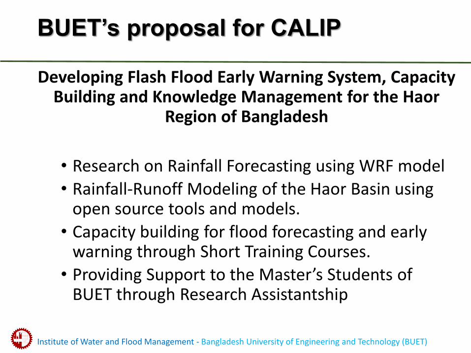
Flow Chart of Methodology
• WRF Data Assimilation
• WRF Rainfall forecasting
• Rainfall Runoff modeling
• Hydraulic Modeling
• Flood Inundation Modeling
• Flood information at the Gauge stations and flood maps
Institute of Water and Flood Management - Bangladesh University of Engineering and Technology (BUET)
Two Recently completed Masters at IWFM on WRF and basin modeling relevant to the BUET proposal on CALIP
• Alfi Hasan’s MSc thesis on “Improvement of forecasting heavy rainfall events using Weather Research and Forecasting (WRF) model”
• Supriya Paul’s MSc theis on Impact of Climate Change Hydrological Modeling of Brahmaputra using SWAT
Institute of Water and Flood Management - Bangladesh University of Engineering and Technology (BUET)
Improvement of forecasting heavy rainfall events using Weather Research and Forecasting (WRF) model
• There are several physical options in WRF, which are responsible for generating rainfall in the model.
• With a selection of suitable physical schemes, the forecast skill of heavy rainfall events can be increased effectively.
• Therefore, this study is conducted to evaluate the high impact rainfall events over Bangladesh using WRF model.
Institute of Water and Flood Management - Bangladesh University of Engineering and Technology (BUET)
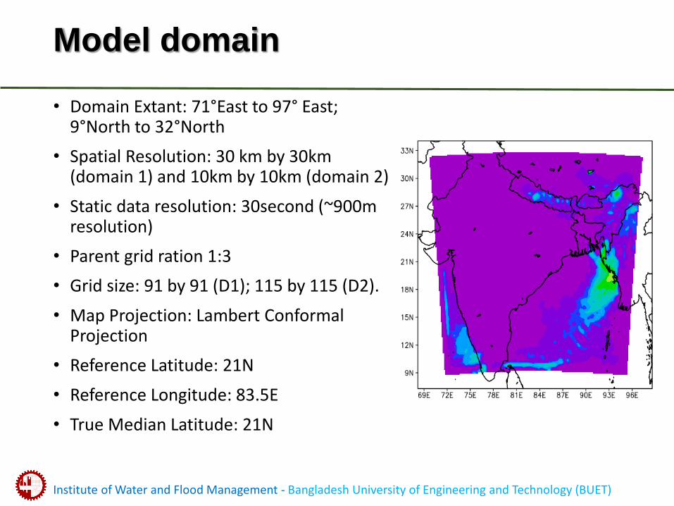
Model domain
• Domain Extant: 71°East to 97° East; 9°North to 32°North
• Spatial Resolution: 30 km by 30km (domain 1) and 10km by 10km (domain 2)
• Static data resolution: 30second (~900m resolution)
• Parent grid ration 1:3
• Grid size: 91 by 91 (D1); 115 by 115 (D2).
• Map Projection: Lambert Conformal Projection
• Reference Latitude: 21N
• Reference Longitude: 83.5E
• True Median Latitude: 21N
Institute of Water and Flood Management - Bangladesh University of Engineering and Technology (BUET)
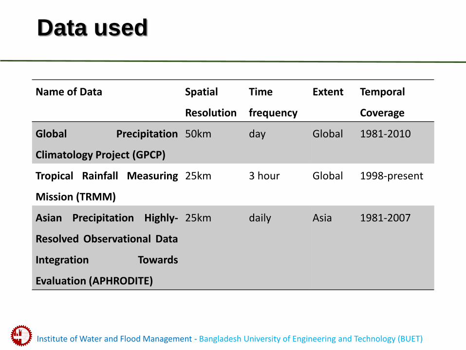
Data used
Name of Data Spatial
Resolution
Time
frequency
Extent Temporal
Coverage
Global Precipitation
Climatology Project (GPCP)
50km day Global 1981-2010
Tropical Rainfall Measuring
Mission (TRMM)
25km 3 hour Global 1998-present
Asian Precipitation Highly-
Resolved Observational Data
Integration Towards
Evaluation (APHRODITE)
25km daily Asia 1981-2007
Institute of Water and Flood Management - Bangladesh University of Engineering and Technology (BUET)
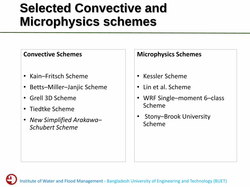
Selected Convective and Microphysics schemes
Convective Schemes
• Kain–Fritsch Scheme
• Betts–Miller–Janjic Scheme
• Grell 3D Scheme
• Tiedtke Scheme
• New Simplified Arakawa–Schubert Scheme
Microphysics Schemes
• Kessler Scheme
• Lin et al. Scheme
• WRF Single–moment 6–class Scheme
• Stony–Brook University Scheme
Institute of Water and Flood Management - Bangladesh University of Engineering and Technology (BUET)
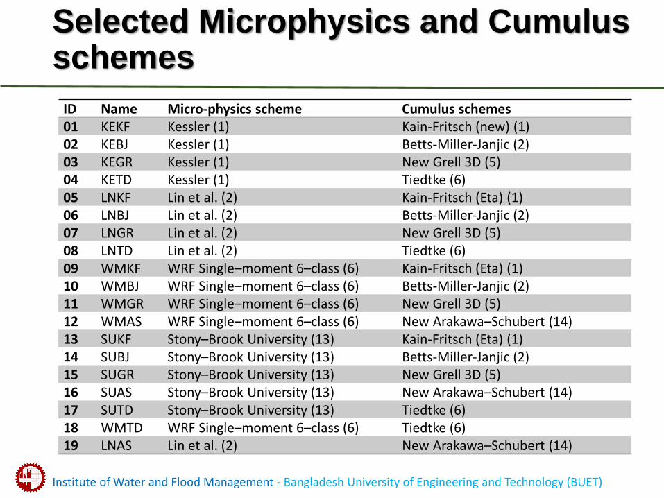
Selected Microphysics and Cumulus schemes
ID Name Micro-physics scheme Cumulus schemes01 KEKF Kessler (1) Kain-Fritsch (new) (1)02 KEBJ Kessler (1) Betts-Miller-Janjic (2)03 KEGR Kessler (1) New Grell 3D (5)04 KETD Kessler (1) Tiedtke (6)05 LNKF Lin et al. (2) Kain-Fritsch (Eta) (1)06 LNBJ Lin et al. (2) Betts-Miller-Janjic (2)07 LNGR Lin et al. (2) New Grell 3D (5)08 LNTD Lin et al. (2) Tiedtke (6)09 WMKF WRF Single–moment 6–class (6) Kain-Fritsch (Eta) (1)10 WMBJ WRF Single–moment 6–class (6) Betts-Miller-Janjic (2)11 WMGR WRF Single–moment 6–class (6) New Grell 3D (5)12 WMAS WRF Single–moment 6–class (6) New Arakawa–Schubert (14)13 SUKF Stony–Brook University (13) Kain-Fritsch (Eta) (1)14 SUBJ Stony–Brook University (13) Betts-Miller-Janjic (2)15 SUGR Stony–Brook University (13) New Grell 3D (5)16 SUAS Stony–Brook University (13) New Arakawa–Schubert (14)17 SUTD Stony–Brook University (13) Tiedtke (6)18 WMTD WRF Single–moment 6–class (6) Tiedtke (6)19 LNAS Lin et al. (2) New Arakawa–Schubert (14)
Institute of Water and Flood Management - Bangladesh University of Engineering and Technology (BUET)
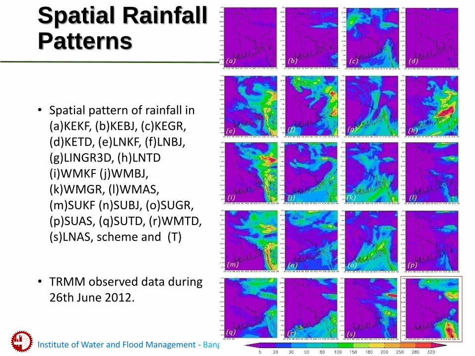
Spatial RainfallPatterns
• Spatial pattern of rainfall in (a)KEKF, (b)KEBJ, (c)KEGR, (d)KETD, (e)LNKF, (f)LNBJ, (g)LINGR3D, (h)LNTD (i)WMKF (j)WMBJ, (k)WMGR, (l)WMAS, (m)SUKF (n)SUBJ, (o)SUGR, (p)SUAS, (q)SUTD, (r)WMTD, (s)LNAS, scheme and (T)
• TRMM observed data during 26th June 2012.
Institute of Water and Flood Management - Bangladesh University of Engineering and Technology (BUET)
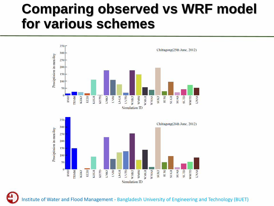
Comparing observed vs WRF model for various schemes
Institute of Water and Flood Management - Bangladesh University of Engineering and Technology (BUET)
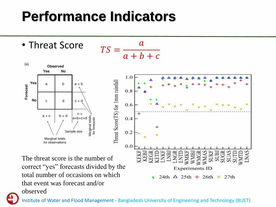
Performance Indicators
• Threat Score 𝑇𝑆 =𝑎
𝑎 + 𝑏 + 𝑐
The threat score is the number of
correct “yes” forecasts divided by the
total number of occasions on which
that event was forecast and/or
observed
Institute of Water and Flood Management - Bangladesh University of Engineering and Technology (BUET)
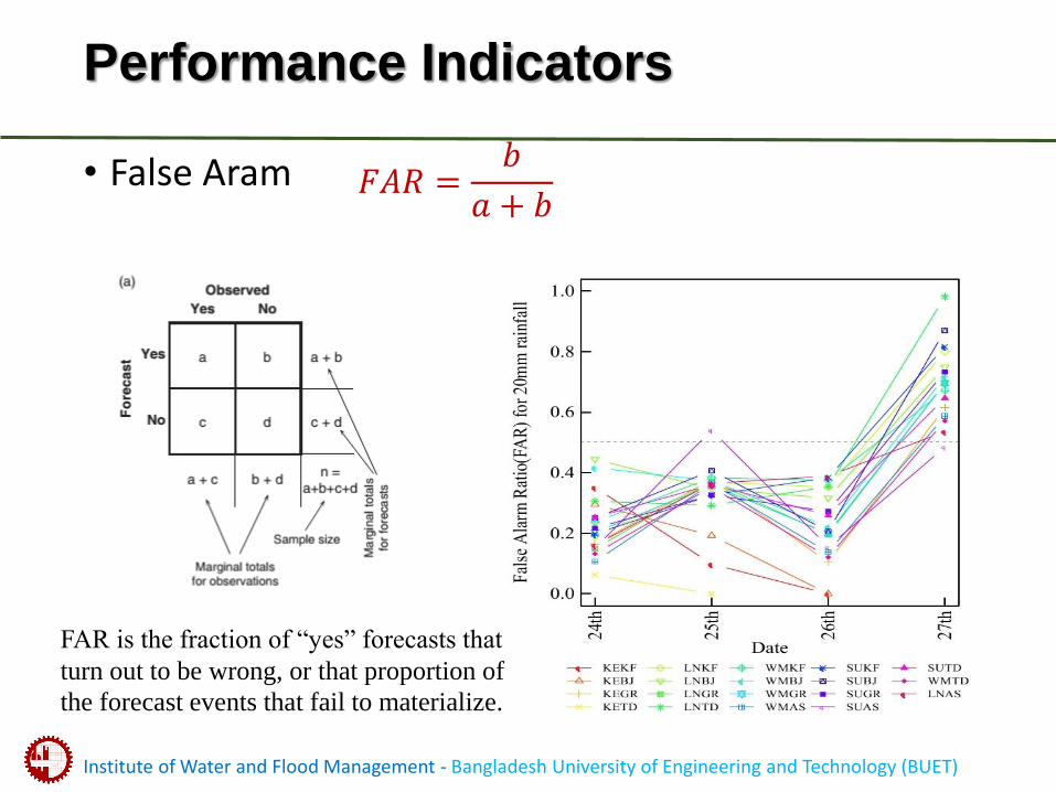
Performance Indicators
• False Aram 𝐹𝐴𝑅 =𝑏
𝑎 + 𝑏
FAR is the fraction of “yes” forecasts that
turn out to be wrong, or that proportion of
the forecast events that fail to materialize.
Institute of Water and Flood Management - Bangladesh University of Engineering and Technology (BUET)
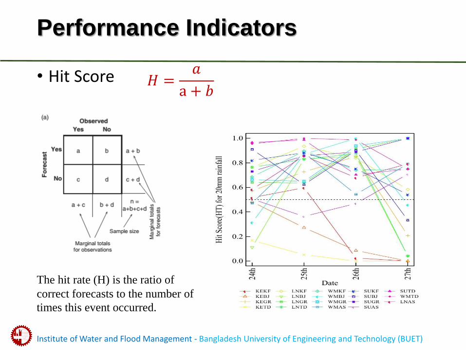
Performance Indicators
• Hit Score 𝐻 =𝑎
a + 𝑏
The hit rate (H) is the ratio of
correct forecasts to the number of
times this event occurred.
Institute of Water and Flood Management - Bangladesh University of Engineering and Technology (BUET)
Summary
• In summary, it has found that Stoony Brook University microphysics scheme with Tiedtke cumulus (SUTD) can produce best rainfall forecast for the high intensive rainfall events over the eastern hilly region of Bangladesh.
• The existing default physical scheme (Kessler and Kain-Fritsch (new) scheme) that is commonly used by Bangladesh Meteorological Department (BMD) has poorly performed in capturing high impact rainfall over the Chittagong Division
Institute of Water and Flood Management - Bangladesh University of Engineering and Technology (BUET)
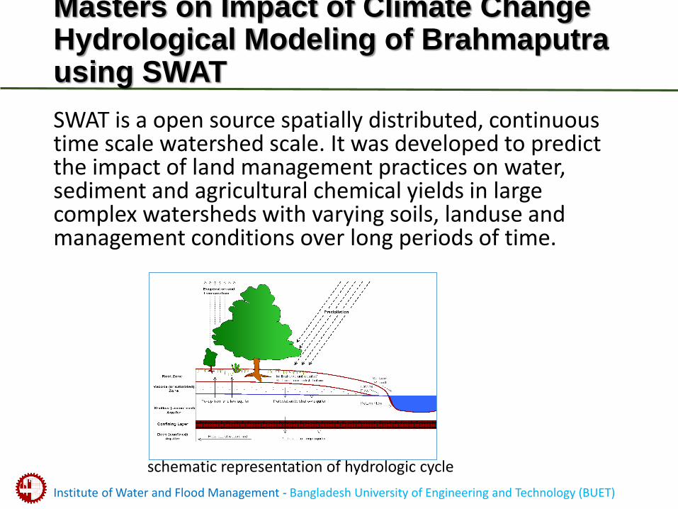
Masters on Impact of Climate Change Hydrological Modeling of Brahmaputra using SWAT
SWAT is a open source spatially distributed, continuous time scale watershed scale. It was developed to predict the impact of land management practices on water, sediment and agricultural chemical yields in large complex watersheds with varying soils, landuse and management conditions over long periods of time.
schematic representation of hydrologic cycle
Institute of Water and Flood Management - Bangladesh University of Engineering and Technology (BUET)
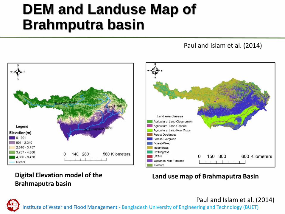
DEM and Landuse Map of Brahmputra basin
Digital Elevation model of the Brahmaputra basin
Land use map of Brahmaputra Basin
Paul and Islam et al. (2014)
Paul and Islam et al. (2014)
Institute of Water and Flood Management - Bangladesh University of Engineering and Technology (BUET)
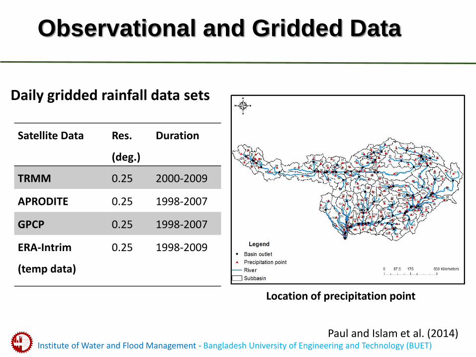
Observational and Gridded Data
Satellite Data Res.
(deg.)
Duration
TRMM 0.25 2000-2009
APRODITE 0.25 1998-2007
GPCP 0.25 1998-2007
ERA-Intrim
(temp data)
0.25 1998-2009
Location of precipitation point
Daily gridded rainfall data sets
Paul and Islam et al. (2014)
Institute of Water and Flood Management - Bangladesh University of Engineering and Technology (BUET)
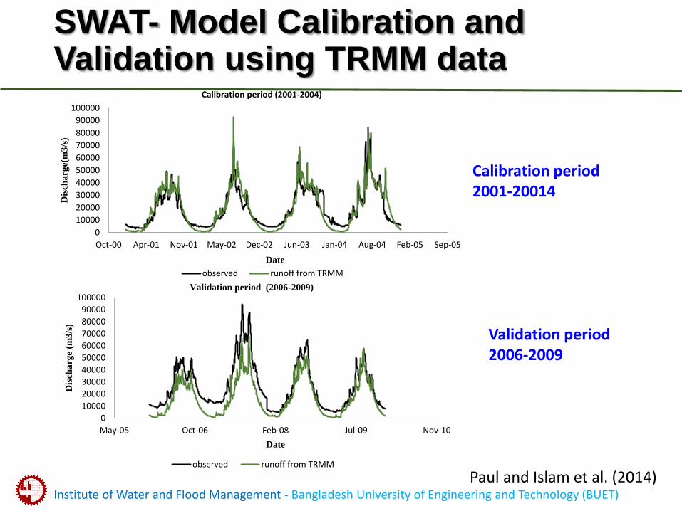
SWAT- Model Calibration and Validation using TRMM data
0
10000
20000
30000
40000
50000
60000
70000
80000
90000
100000
Oct-00 Apr-01 Nov-01 May-02 Dec-02 Jun-03 Jan-04 Aug-04 Feb-05 Sep-05
Dis
cha
rge(
m3
/s)
Date
Calibration period (2001-2004)
observed runoff from TRMM
0
10000
20000
30000
40000
50000
60000
70000
80000
90000
100000
May-05 Oct-06 Feb-08 Jul-09 Nov-10
Dis
cha
rge
(m3
/s)
Date
Validation period (2006-2009)
observed runoff from TRMM
Calibration period 2001-20014
Validation period 2006-2009
Paul and Islam et al. (2014)
Institute of Water and Flood Management - Bangladesh University of Engineering and Technology (BUET)
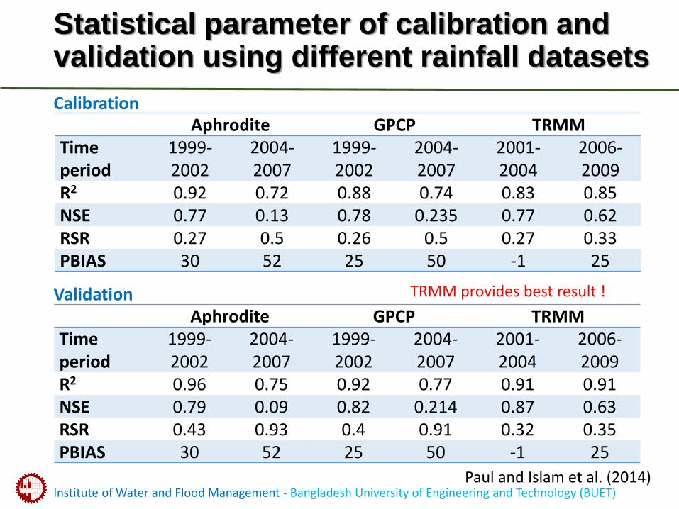
Statistical parameter of calibration and validation using different rainfall datasets
Aphrodite GPCP TRMMTime period
1999-2002
2004-2007
1999-2002
2004-2007
2001-2004
2006-2009
R2 0.92 0.72 0.88 0.74 0.83 0.85NSE 0.77 0.13 0.78 0.235 0.77 0.62RSR 0.27 0.5 0.26 0.5 0.27 0.33PBIAS 30 52 25 50 -1 25
Aphrodite GPCP TRMMTime period
1999-2002
2004-2007
1999-2002
2004-2007
2001-2004
2006-2009
R2 0.96 0.75 0.92 0.77 0.91 0.91NSE 0.79 0.09 0.82 0.214 0.87 0.63RSR 0.43 0.93 0.4 0.91 0.32 0.35PBIAS 30 52 25 50 -1 25
Calibration
Validation TRMM provides best result !
Paul and Islam et al. (2014)
Institute of Water and Flood Management - Bangladesh University of Engineering and Technology (BUET)
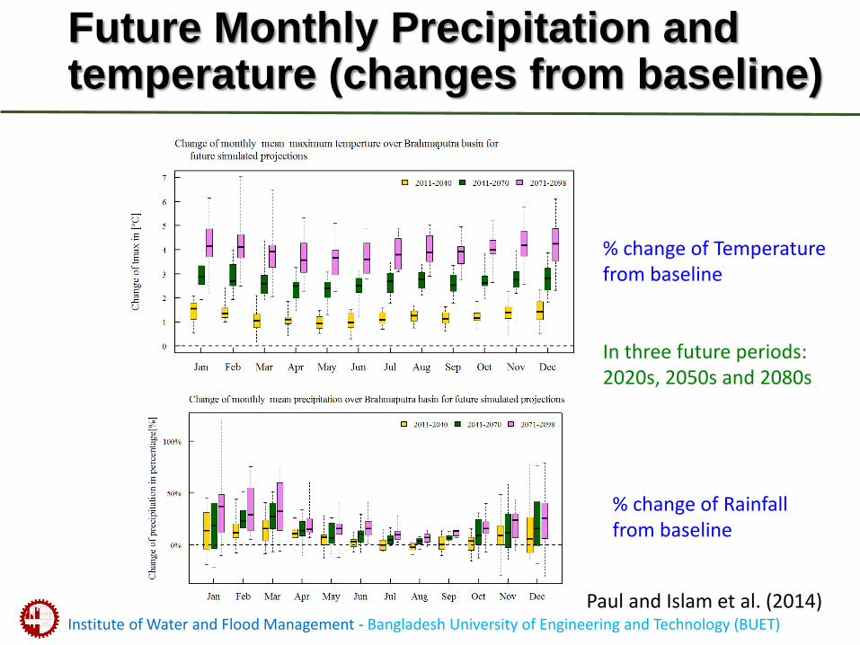
Future Monthly Precipitation and temperature (changes from baseline)
% change of Temperaturefrom baseline
In three future periods: 2020s, 2050s and 2080s
% change of Rainfallfrom baseline
Paul and Islam et al. (2014)
Institute of Water and Flood Management - Bangladesh University of Engineering and Technology (BUET)
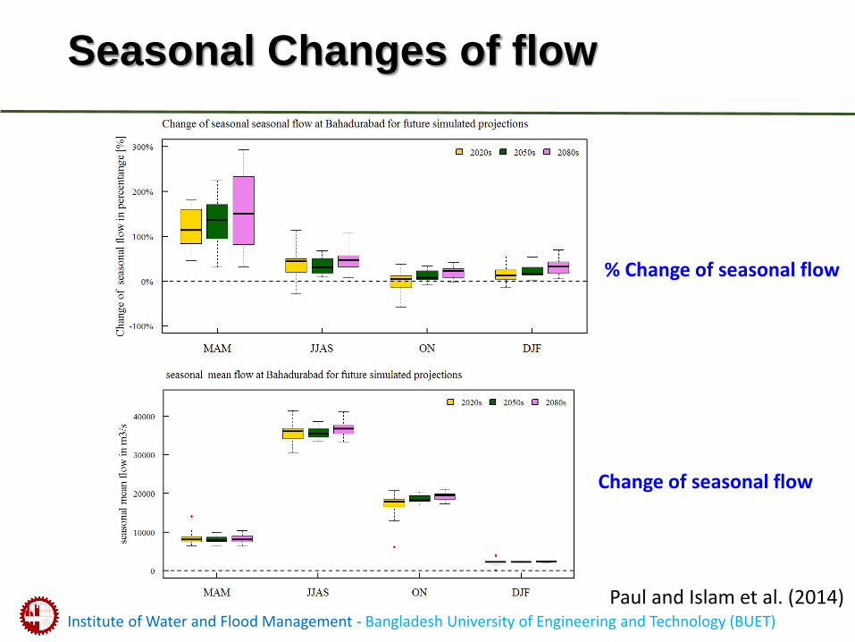
Seasonal Changes of flow
Change of seasonal flow
% Change of seasonal flow
Paul and Islam et al. (2014)
Institute of Water and Flood Management - Bangladesh University of Engineering and Technology (BUET)
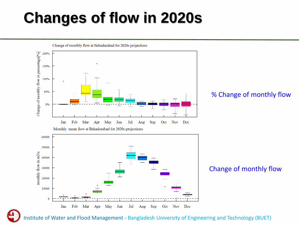
Changes of flow in 2020s
Change of monthly flow
% Change of monthly flow
Institute of Water and Flood Management - Bangladesh University of Engineering and Technology (BUET)
Summary
• The uncertainty for pre-monsoon flow maintain through the end century which is very high. But the confidence level for increasing monsoon flow are more prominent.
• Majority of the model predicts future monsoon flow will be increase by 5 to 10%.
Institute of Water and Flood Management - Bangladesh University of Engineering and Technology (BUET)
Some relevant on-going studies on climate Change at BUET lead by my research group (Hydrology and Climate Change, HCL)
• EU funded “High End Climate Impact and Extremes (HELIX)” lead by Exeter University, UK
• Norwegian Ministry Funded “Transforming Climate Knowledge with and for Society: mobilizing knowledge on climate variability with communities in northeast Bangladesh (TRACKS)” lead by Burgen University.
• DANIA Funded “Combating Cholera caused by Climate changes of Bangladesh”, lead by University of Copenhagen.
http://helixclimate.eu/home
http://web9.swayam-hosted.co.uk/tracks/
http://drp.dfcentre.com/project/combatting-cholera-caused-climate-changes
Institute of Water and Flood Management - Bangladesh University of Engineering and Technology (BUET)
On-going projects at IWFM, BUET
• AFACI funded research in collaboration with BARC on “Production and Service of Agro-meteorological Information for the Adaptation to Climate Change in Bangladesh”.
• DOE funded research in collaboration with CEGIS on “Assessment of Sea Level Rise and Vulnerability in the Coastal Zone of Bangladesh through Trend Analysis”.
• (PI- Prof Munsur Rahman, IWFM for Bangladesh) Funded by NERC, DFID, ESRC in collaboration with Southampton university “Ecosystem Services for Poverty Alleviations”
http://www.espadelta.net/partners/bangladesh/
Institute of Water and Flood Management - Bangladesh University of Engineering and Technology (BUET)
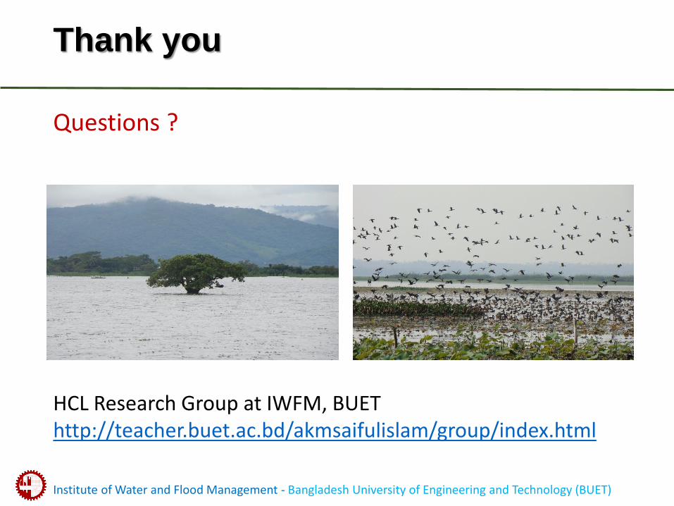
Thank you
Questions ?
HCL Research Group at IWFM, BUEThttp://teacher.buet.ac.bd/akmsaifulislam/group/index.html