identification of options to minimize water...
TRANSCRIPT

IDENTIFICATION OF OPTIONS TO MINIMIZE WATER
USE CONFLICTS BETWEEN NEAR DAM USERS AND
UPSTREAM USERS
Final Report
Submitted By: Group Four
M M H
M A S
F A
K N
S B F
March 2016
Institute of water and flood management
Bangladesh University of Engineering and Technology

IDENTIFICATION OF OPTIONS TO MINIMIZE WATER
USE CONFLICTS BETWEEN NEAR DAM USERS AND
UPSTREAM USERS
Final Report
Research Team (Group 4)
M M H (Roll: ________)
M A S (Roll: ________)
F A (Roll: ________)
K N (Roll: ________)
S B F (Roll: ________)
22 March 2016
Institute of water and flood management
Bangladesh University of Engineering and Technology

i
ACKNOWLEDGEMENT
At first the authors wish to express their profound gratitude and sincere appreciation
to Dr. Mashfiqus Salesin, Associate Professor and Dr. Shah Alam Khan, Associate
Professor Institute of Water and Flood Management (IWFM), Bangladesh University
of Engineering and Technology (BUET), and also to Dr. Hamidul Haque, Research
Co-coordinator, CB Project for their active support, advice and guidance throughout
the study.
The authors express their special thank to Shaikh Muzakka Zaher, Executive
Engineer, LGED, Cox’s Bazar, for providing logistic and support services at the
project sites.
Authors are also grateful to Mr. Mosarraf Hossain, Socio-economist, LGED, Cox’s
Bazar for his cordial help to enrich the study.
Authors would like to thank LGED, DAE, and UNO of Cox’s Bazar for their support
to complete the study. Authors are also grateful to CEGIS for their cordial support in
completing the study.
Authors are also like to thank other research groups, Local people of Bakhhali rubber
dam project area for their support and valuable advices to enrich the study.
Without their valuable direction and cordial assistance it would have been impossible
to carry out this study under a number of constraints, time limitation in particular.

ii
ABSTRACT
Bakkhali River is an important river from the economic and geographical viewpoint
in Cox’s Bazar district. Due to high demand of water local people used to construct
earthen dam across the river which later on was permanently replaced with a rubber
dam by LGED for the fulfillment of the demand. The availability of water varies
from near dam to upstream. The people of upstream get less water than the people at
near dam area. As there is presence of low lying areas in near dam site, excessive
rainfall in the catchment area causes flooding/ inundation problem in the near dam
areas, which adversely affect the crop production and their livelihoods. To release
this excess water, if the dam is deflated for a short period of time then people living
in the upstream region do not get water according to their requirement for irrigation.
To go in to deep of the actual problem consultation with the stakeholders, women
folks, public representatives, authorities and administrator were conducted. In this
study cause of conflict and options to minimize the conflict was identified with
details discussion with different stakeholders. Inundation map was also developed
using DEM at three different water levels to locate actual affected area.

iii
TABLE OF CONTENTS
Page
No.
ACKNOWLEDGEMENT i
ABSTRACT ii
CONTENTS iii
LIST OF TABLES v
LIST OF FIGURES v
CHAPTER ONE: INTRODUCTION
1.1 Introduction 1
1.2 Objective of the Study 2
1.3 Scope of Work 2
1.4 Limitations of the Study 2
CHAPTER TWO: STUDY AREA
2.1 Location of the study area 3
2.2 Climate of the study area 3
2.4 Characteristics of Bakkhali Rubber Dam 4
2.5 Topography of the benefited area 6
2.6 Land use distribution 6
2.7 General Hydrology 6
CHAPTER THREE: Methodology and data collection
3.1 Introduction 7
3.2 Methodology 7
3.2.1 Development of research Question 7
3.2.2 Social Survey Methods 7
3.3 Data Collection
3.3.1 Data on economic loss due to flooding in near dam areas 8
3.3.2 Secondary data collection 8

iv
CHAPTER FOUR: Conflict Evaluation
4.1 Introduction 9
4.2 Conflict between near dam and upstream users 9
4.3 Conflict between rice cultivation and vegetable cultivations in the
lower dam area.
10
4.4 Conflict Between upland farmer and people living in the low-lying
beel areas of upstream zone
10
4.5 Views of women living in near dam areas 10
CHAPTER FIVE: Analytical Approach to evaluate the problem
5.1 Causes of flooding 11
5.2 Causes of water shortage in upstream of dam 11
5.3 Analysis of Area – Elevation Curve 12
5.4 Inundation map from DEM 13
5.5 losses due to crop damage 16
CHAPTER SIX: Identification of options to minimize water use conflict
6.1 Options identified by local people to mitigate the water use conflict 17
6.2 Cost estimation of identified option 18
CHAPTER SEVEN: Conclusion and recommendation
7.1 Conclusion and Recommendation 19
7.2 Scope for further study 20
REFERENCE 21
APPENDIX A 22
APPENDIX B 24
APPENDIX C 28
APPENDIX D 32

v
APPENDIX E 44
LIST OF TABLES
Table No Table Name Page No
Table-2.1 Monthly average and 80% dependable rainfall at Bakkhali. 3
Table-2.2 Important features of Bakkhali rubber dam. 4
Table-5.1 Losses in near dam area due to flooding 16
Table-6.1 Estimation of cost of identified options to mitigate water use
conflict
18
LIST OF FIGURES
Serial No Name of Figure Page
Figure 2.1 Irrigation coverage area of the Bakkhali rubber dam 5
Figure 5.1 Area-elevation curve 12
Figure 5.2 Inundated areas when the dam is inflated up to +3.0 m PWD if there is no closure at off-taking canals.
13
Figure 5.3 Inundated areas when the dam is inflated up to +2.5 m PWD if there is no closure at off-taking canals.
14
Figure 5.4 Inundated areas when the dam is inflated up to +2.0 m PWD if there is no closure at off-taking canals.
15

1
CHAPTER ONE
INTRODUCTION
1.1 Introduction:
Amongst all the other main rivers of Cox’s bazar the Bakkhali River is the most
important from the economic and geographical viewpoint. Due to high demand of water
during dry season for agricultural production, a bulk of water is withdrawn by the local
people for irrigation of agriculture fields for production of rice and cereals. They have
been practicing this since 1952 by building earthen dam across the river, which later on
was permanently replaced with a rubber dam by LGED for the fulfillment of the demand.
The dam is usually inflated in December – January to retain water (volume 80Mm3) and
to prevent salinity intrusion. The retained water is used for irrigation of Boro rice by
LLP’s up to 12 Km upstream of dam site in dry season (January – May). The irrigation
coverage area is divided in to smaller blocks. The dam is deflated in March – April. The
availability of water varies from near dam to upstream. The people of upstream get less
water than the people at near dam area. The presence of low lying areas in near dam site,
excessive rainfall in the catchment area causes flooding/ inundation problem in the near
dam areas, which adversely affect the crop production, livelihoods and their household
activities. To release this excess water, if the dam is deflated for a short period of time
then people living in the upstream region do not get water according to their requirement
for irrigation. It is one of the major conflicting issues prevailing in Bakkhali Rubber Dam
Project.
1.2 Objective of the study:
The objective of this study is to know the reasons of flood and identify probable options
to minimize the extent of flooding in the near dam area and to ensure adequate water for
irrigation in the upstream areas.

2
1.3 Scope of Work:
The scope of the work includes:
Study the causes of Flood in the region.
Study the extent of inundation and damage of crops, livestock and households due
to flooding.
Causes of water shortage in upper reach.
Reasons for conflict between stakeholders in near dam and upstream area.
Study the alternatives to solve the conflict and the consequences.
Identify options to resolve the conflict between stakeholders.
1.4 Limitation of the Study:
Due to short duration of research work detail survey of actual crop damage could
not be ascertained.
The size and vantage of regulators on khal could not be calculated (Hydrologic
and hydraulic) due to non-availability of detail survey data. So the size and cost of
structure has been estimated based on experience from similar project.

3
CHAPTER TWO
DESCRIPTION OF STUDY AREA
2.1 Location of the Study Area
The main rivers of Cox’s Bazar are the Bakkahli, Matamuhuri, Rezu and Naff. Besides
these some important canals are flowing down to the Bay of Bengal e.g. Sonaichari,
Eidgaon, etc. From the economic and geographical viewpoint, the Bakkhali is the most
important among others. Cox’s Bazar town is situated at the downstream of the river.
Bakkhali is a major tidal river in the study area that originates in the Arakan mountains,
flows north, then turns to the west flowing past Ramu and Cox’s Bazar towns, finally
falling into the Bay of Bengal after meeting with several tributaries. The average tidal
range at Cox’s Bazar on the Bakkhali is about 2.0 m.
2.2 Climate
Most of the rainfall in dry season in the area occurs during April. Monthly average and
80% dependable rainfall amounts are shown in Table 2.1.
Table 2.1: Monthly average and 80% dependable rainfall at Bakkhali.
December January February March AprilMean rainfall (mm) 7.8 6.6 12.7 19.8 102.280% dependable rainfall (mm) 0 0 0 0 3.3
Source: Field practical reader WFM - 6209
Average annual rainfall of the year 1977-78 was observed as notable rainfall and was
confined in the period from April to September, with the peak in June to August. Similar
trend was found in the year 2001-02 in the Bakkhali River and adjacent areas.
2.3 Livelihood
Most of the people living in areas adjacent to the rivers and irrigation canals, especially in
the upstream region, are engaged in agricultural activities. Fishermen live mostly in the
downstream reaches of the rubber dam. Some fry catchers live upstream of the dam and

4
some are present near the confluence downstream of the dam. Most of the fisher folks
depend on the sea for fish rather than fish in the river. The gears they use are mostly
Behundi net (ESBN), Push net, Bag net, etc. Although culture fisheries are present within
the project area, activities are mostly controlled by the WMCA members and local elites.
2.4 Characteristics of Bakkhali Rubber Dam
Construction of Bakkhali rubber dam was started in February 1995 and completed in
May 1995. The dam collapsed in January 2001, and was later reconstructed in 2004-05.
The dam conserves fresh water upstream and prevents saline water intrusion from
downstream. The dam is inflated in December-January and the retained water is used for
irrigation of Boro rice by LLPs up to 12 km upstream of the dam site in dry season (from
January to May). Figure 2.1 shows irrigation coverage area served by the Bakkhali dam.
The irrigation coverage area is divided into smaller ‘blocks’. The dam is deflated in
March-April turning the river back to free flowing conditions.
Table 2.2: Important features of Bakkhali rubber dam
Description Bakkhali dam
Length of dam bag 84 mHeight of dam bag 3.5 mWeight of dam bag 14 tonMax. retention height 4 mProtective works:
Upstream 9 mDownstream 13 rn
Filling system:Pump capacity 150 m3/hrFilling time 8 hrsFilling fluid Water
Irrigation area 6000 haCost 36 M Tk.Construction year 1994-95
Source : Field practical Reader WFM 6209

5
Figure 2.1: Irrigation coverage area of the Bakkhali rubber dam.Source: Field Practical Reader WFM - 6209

6
2.5 Topography of benefited areas:
The benefited area has a flat topography having a fluctuation of 2 m in its ground level.
The lands are cultivated by secondary pumping system. There are pockets of low lying
areas in the fields which are being inundated during the beginning of irrigation storage.
Actually they are being used to store additional water.
2.6 Land Use
The cultivated lands have three broad types of crops. In high lands and lands near to the
Bakkhali River, most crops are vegetable and spices. Because of its special soil type in
areas where surface water pumps are effective people cultivate paddy. In low lying areas
long stem rice is being cultivated.
2.7 General Hydrology
The water is stored in the Bakkhali River at 3.0 m PWD at the beginning of irrigation
season (During Boro crops, mid December). This water is carried to the interior users
either through connecting khals or through long field channels. The connecting khals
generally drain monsoon water from the interior catchments. Where water through the
interior canals inundates the lands by the stored water from Bakkhali River, people close
the openings of the khals near the river. The water level upstream of Bakkhali Rubber
dam reduces gradually by withdrawing water for irrigation and evapo-transpiration and
goes below existing ground level up to 2.0 m PWD. From area elevation curve and
inundation map it is seen that if water is allowed freely on ground at +3.0 PWD,
approximately fifty percent of land (3000 ha) gets inundated which are being protected
by closing the offtaking khals and existing drainage regulators. When water level comes
down to +2.0 m PWD, only the connecting khals and ponds have the stored water.
There are some high lands where water cannot be pumped from stored water because of
the level of field channel, are cultivated through deep or shallow tube well.
7
CHAPTER THREE
METHODOLOGY AND DATA COLLECTION
3.1 Introduction:
The methodology adopted in this study to know the reasons of flood and identify
probable options to minimize the extent of flooding in the near dam area and to ensure
adequate water for irrigation in the upstream areas.. This chapter contains the detail
description of methods which was followed to collect data from different stakeholders
and different sources.
3.2 Methodology:
3.2.1. Development of research Question:
At first a research question was develop to identify the water use conflict in the Bakkhali
Rubber Dam project (Appendix – A). After this a set of sub-questions were also
developed to address the research question.
3.2.2. Social Survey Methods:
A. Focus group Discussion:
Focus group discussions were conducted with different stakeholders of the project.
Depending on the research objective, in total four number of focus group was identified
to know the actual condition. The groups include
I. Near dam farmers,
II. Near dam affected farmers,
III. Near dam affected women folks and
IV. Upstream farmers.
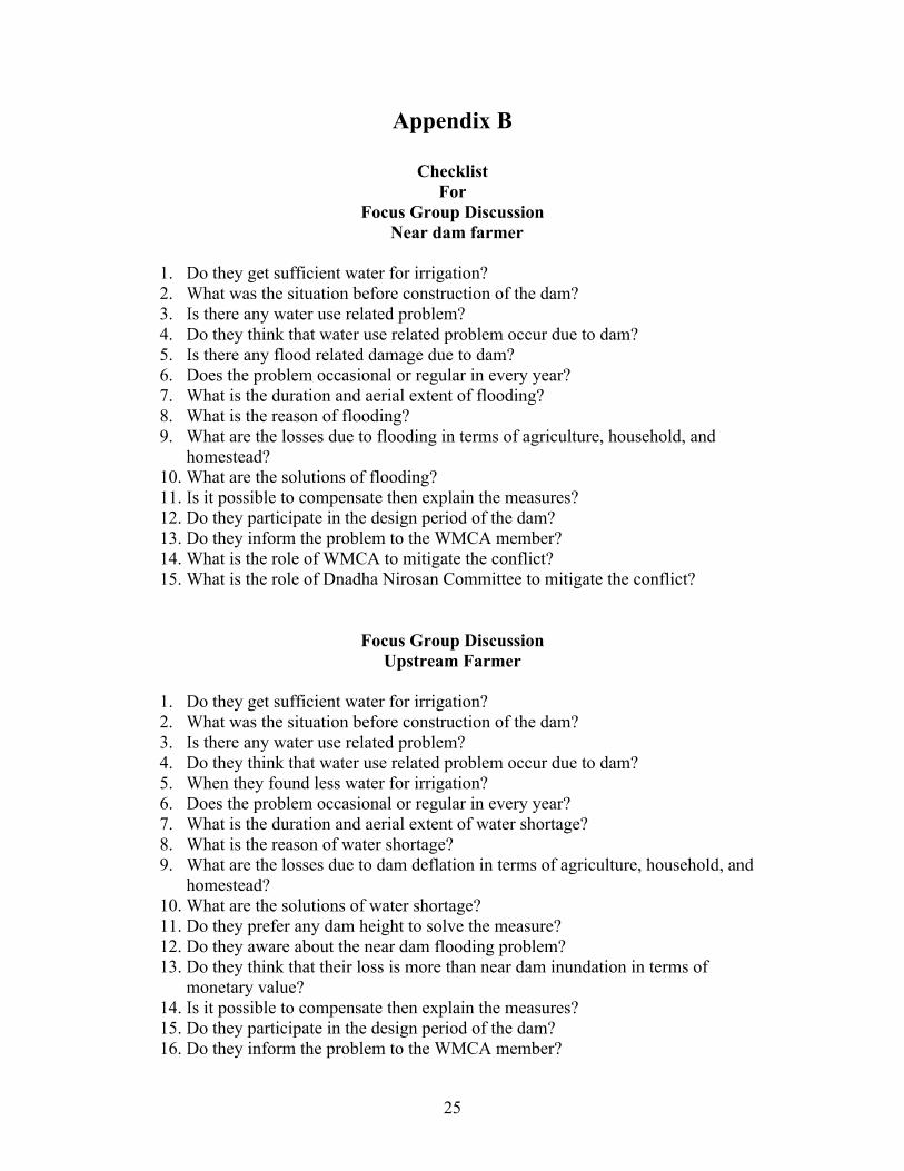
A set of checklist was prepared for discussing with each group (Appendix – B).

8
B. Informal Interview:
Informal interviews were also conducted with block managers near dam and upstream,
Lineman mid-stream, Secretary of WMCA, Chairman of WMCA, LGED personnel,
DAE personnel, TNO and Public representative for collection of relevant information. A
set of checklist (Appendix – B) was followed for each group to collect information from
them. (Appendix- E – Contains relevant pictures)
3.3 Data collection:
3.3.1. Data on economic loss due to flooding in near dam areas:
Data on crop damage at near dam sites due to flooding were collected through field visit
at Jhilongjha, P.M Khali, Razarkul, Chakmarkul sites; interviewing with block manager
near dam and upstream, Secretary of WMCA, Chairman of WMCA, Public
representatives, Agriculture officer, UNO and Focus group discussions with near dam
farmers, near dam affected farmers, near dam affected women folks and upstream
farmers. Their comments were verified by field observation by the study team.
3.3.2. Secondary data collection:
Contour map of the study area was collected from LGED. Ground level data are
collected from CEGIS and DEM analysis, Inundation map, area elevation curve has been
analyzed by the members of group – 4 and collected information are furnished in
Appendix – C. Information on the study area were also collected from existing reports on
the Bakhhali Rubber Dam Project.

9
CHAPTER FOUR
CONFLICT EVALUATION
4.1 Introduction
To get the irrigation water throughout the whole irrigation period the major conflict is
between the near dam users and upstream users regarding water use. But there are other
conflicts among near dam users and among upper dam users, which is found during field
visit and analytical results, also support the some which has been addressed in this study.
The conflict in that area is basically due to inflation of dam up to +3.0m PWD at the
starting of the season. The water level retained by the dam causes inundation in low lying
area on the other hand this level is required for irrigation in upstream areas to cover the
whole dry season.
4.2 Conflict between near dam and upstream users
Before the seeding period water is stored in the Bakkhali River at 3.00mPWD by
inflating the rubber dam (during beginning of December) or else enough water cannot be
stored for the whole irrigation period. The mostly affected people for the water crisis are
the upstream users. Because if water level falls even 0.3m below +2.00m level the river
bed will not allow any pump to operate and huge lands will lose the standing crop.
But the inundation level at +3.00m PWD causes the loss of vegetable crops on both
banks of Bakkhali River up to Banglabazar Bridge. Although the actually assured them
that the vegetable field will be protected by dykes on both banks but they were not
constructed. Probable reason for not constructing the dyke is the existence of bank
erosion.
The low-lying areas on both banks in spite of closing of off-taking canals are also
inundated and it stays like that for a month on the field. So, they have to plant the paddy
at a later stage and get less crops.
The affected people want to keep the top of the rubber dam 0.6m lower than existing one
but majority of the beneficiaries are against it. Their argument is to give benefit to larger
number of people approximate 10% people should accept the loss. But nobody is ready to
pay for it. There the conflict begins.

10
4.3 Conflict Between rice cultivation and vegetable cultivations in the lower dam area.
As the vegetable and spices cultivation is much more profitable than paddy crop the
farmers on the near bank floodplains of the Bakkhali river up to Banglabazar Bridge are
more interested to cultivate vegetables and want to lower the dam height while the paddy
cultivators want to raise the dam height to get enough water through the whole irrigation
period . The paddy cultivator suggested them to produce paddy on their low lying areas
but they do not agree and the conflict begins.
There are complaints that to save pumping cost the secretary of WMCA inundates more
land in some area to give gravity irrigation to some land for one month, which is true to
some extent.
4.4 Conflict Between upland farmer and people living in the low-lying beel areas of upstream zone.
To get enough water throughout the whole irrigation period the required water level
inundates some low pockets in the interior upland zones through connecting Khals and
they were never aware about the possible rectification measures. So there were more
complaints from upstream low lying areas than the near dam areas through the UNO of
Ramu upazilla to reduce the dam height.
4.5 Views of women living in near dam areas
Due to inflation of dam up to 3.0m PWD they suffer flooding each year. Those who have
high land are being more benefited than those who have low land near the dam. Damaged
crops due to inundation were cauliflower, cabbage, potato and chili which are more
profitable. Due to inundation, the stagnant water in the fields causes mosquito problem
and cattle suffer from Pneumonia. Women of that area are not member of WMCA. It
was observed during field visit that women were included in the WMCA to fulfill the
requirements of LGED to implement the sub-project but no active participation of women
was observed there.

11
CHAPTER FIVE
ANALYTICAL APPROACH TO EVALUATE THE PROBLEM
5.1 Causes of flooding:
From FGD and informal interview with different stakeholder causes of flooding in near
dam area were identified, which was also verified during field visit. Following are the
causes of flood obtained from different stakeholders:
o Inflation of rubber dam to its desired level (+3.00m PWD) causes
inundation in the near dam area approximately (2 acres).
o Opening of drainage outlets (Chhora) from low lying beel areas.
o In the year 2007 delayed closing of drainage outlets (Chhora) from low-
lying beel areas caused flood
o Due to excess rainfall during irrigation period.
o Malfunctioning of rubber dam it self.
5.2 Causes of water Shortage in upstream of dam:
From FGD and informal interview with different stakeholder causes of water shortage in
upstream area were identified, which was also verified during field visit. In the opinion of
people living in upstream of the rubber dam causes of water shortage during dry season
for irrigation are described below:
o Lowering of the Rubber dam than the desired level
o Delayed inflation of dam.
o Presence of excess pumps on the upstream of project boundary.
o Construction of small earthen embankments across the upstream hilly
streams (Chhoras).
o Malfunctioning of rubber dam it self.

12
5.3. Analysis of Area – Elevation Curve:
The area elevation curve and inundation map in the fig: 5.1 clearly indicates that if the
water is allowed to flow on the command areas at FSL approximately 50% of land will be
inundated. But the presence of control structure and earthen closures constructed by the
local people generally protect a large area of land from inundation. Calculation of area
elevation curve is attached in Appendix C. So, information obtained from the FGD and
interview appears to be correct.
Area-elevation
1
1.5
2
2.5
3
3.5
4
4.5
5
0 500 1000 1500 2000 2500 3000 3500 4000 4500 5000 5500 6000 6500 7000
Area in hectar
Ele
vatio
n
Fig 5.1: Area-elevation curve

13
5.4 Inundation map from DEM:
Areas possible to be inundated due to dam inflation at three different levels are shown
here in red color.
Fig 5.2: Inundation areas when the dam is inflated up to +3.0 m PWD if there is no closure at off-taking canals.
From this map we can see that 50% of the land will be inundated if the dam is inflated to
its full height at +3.00 m PWD. But closures at different off-taking canal mouth prevent
flooding in maximum area of near dam and upstream low lying region. There is a wooden
gate at Patli khal which protect the PM Khali union from flooding. In addition to that
farmers of low lying areas can not cultivate their lands in due time as the inflation of dam
Area-elevation
1
1.5
2
2.5
3
3.5
4
4.5
5
0 500 1000 1500 2000 2500 3000 3500 4000 4500 5000 5500 6000 6500 7000
Area in hectar
Ele
va
tio
n

14
creates flooding in the field. After the gradual decrease of water level due to pumping out
of water for irrigation, the farmers can cultivate their lands.
Fig 5.3: Inundated areas when the dam is inflated up to +2.5 m PWD if there is no closure at off-taking canals..If the dam is inflated up to 2.5 m PWD 33.33% of total command area will be inundated.
From the figure it is clear that wooden gate at Patli Khal prevents flooding in large area.
Area-elevation
1
1.5
2
2.5
3
3.5
4
4.5
5
0 500 1000 1500 2000 2500 3000 3500 4000 4500 5000 5500 6000 6500 7000
Area in hectar
Ele
va
tio
n

15
Fig 5.4: Inundated areas when the dam is inflated up to +2.0 m PWD if there is no closure at off-taking canals.
From the map it is clear that there will be no inundated crop fields if the water level stays
at + 2.0m PWD. During the period field visit the dam was inflated up to 2m PWD and it
was observed that there were no inundated crop fields in that area. But still the gate of
Patli khal was partially closed to protect the surrounding land from inundation.
Area-elevation
1
1.5
2
2.5
3
3.5
4
4.5
5
0 500 1000 1500 2000 2500 3000 3500 4000 4500 5000 5500 6000 6500 7000
Area in hectarE
leva
tio
n

16
5.5 losses due to crop damage:
To ascertain losses, economic analysis also done, which can be minimized through
structural intervention, and calculations are attached in Appendix – C. All the data were
collected from stakeholder during field visit which is available in Day Reports attached in
Appendix - D
Table 5.1: Losses in near dam area due to flooding:
Total area (ha)
Irrigablearea
(acre)
Crop damage
area (acre)
Production per acre
(Kg)
Price of crop
(Tk./kg)
Loss of
yield (%)
Production loss per
acre (Tk.)
Total loss
(Tk.)
6000 10,787 1,079 2200 18 15 5940 64,09260

17
CHAPTER SIX
OPTIONS TO MITIGATE WATER USE CONFLICT
6.1 Options identified by local people to mitigate the water use conflict:
After analyzing the FGD and interview results and field verification, the following
options came in the picture to solve the conflict between water users. (Source: Day
reports Appendix – D)
o Construction of flood embankment up to Banglabazar Bridge.
o Construction of regulators on off-take canals.
o Construction of closures on off-take canals in due time
o Construction of flood embankment on the bank of Patli Khal.
o To maintain the water level as in this year (2007-2008).
o Timely inflation of the Rubber dam as in this season(18th
December’ 07)
o Khola khal, Noya khal and Pera khal in Chanderpara needs sluice
gate.
o The present conflict can be solved through crop diversification,
viz- if spinach is cultivated instead of spices and vegetables then
they can harvested before the dam is inflated.
o The seedbeds can be protected by opening the gates of Mantargoda
and Guillarchari regulators by draining out the excess water.
o The seedbeds can be prepared on a higher ground so that they are
not inundated.
o Those who have lost their crops due to inundation can be
compensated by the beneficiaries.
o In the inundated areas fish cultivations can be done instead of
crops.
o When the fields are inundated, lowering the dam height for a small
period of time can solve the problem.

18
o Proper management of Rubber Dam
o The selection of WMCA members should be proper.
o Active participation of women member should be ensured in the
WMCA.
o The WMCA members can resolve the conflict through proper
initiative.
o WMCA meetings should be held regularly.
6.2 Cost estimation of identified option:
Table 6.1: Estimation of cost of identified options to mitigate water use conflict:
Item no.
Item UnitUnit Cost
Tk.Total cost
Tk.
1Earthen Embankment along both side of the riverbank
4 km 675/m 27,00,000
2Control structures with wooden gates
6 locations 2,00,000 each 12,00,000
3Drainage structures(New construction)
3 nos. 6,00,000 each 18,00,000
4Patli Khal re-excavation and embankment constructionalong both side of the khal
4 km 675/m 27,00,000
5Renovation/ maintenance of existing structure 3 nos. 1,00,000 3,00,000
Total Investment Cost = 87,00,000
* In one year farmers incur a loss nearly same as the amount that could be invested to solve the problem.

19
CHAPTER SEVEN
CONCLUSION AND RECOMMENDATIONS
7.1 Conclusion and recommendation:
From the above discussion and analysis, it is clear that a conflict exists between
stakeholders, which should be solved by the WMCA, local authorities, and LGED with
an integrated approach by ensuring people participation.
To solve the conflict between stakeholders in near dam areas and upstream users, among
downstream users and among upstream users following recommendation are made:
One embankment should be constructed on both bank of Bakkhali River up to
Banglabazar Bridge keeping total set back distance.
At each of the off taking canal heads one regulator should be constructed with
wooden fallboard gates, which can be repaired and maintained by the
stakeholders. It should be done both at upstream and down stream.
Seedbeds should be prepared on relatively higher ground.
Women members should be associated in the WMCA with active participation.
WMCA should be more active and regular meeting should be held on the
presence of the Executive Engineer of LGED, UNO, UP chairman and
Agriculture officer and solve the conflict in an integrated approach, having proper
technical backups.
WMCA should call regular meetings of conflict resolution committee to minimize
the water use conflict and inform members about the actual situation.

20
Drainage regulators with flap gates should be constructed/ renovated to drain the
rain water at down stream of the rubber dam to protect the low-lying areas from
flooding from excess rains during fully inflated rubber dam.
Patli khal should be re-excavated with embankment on its two sides so that water
can stay inside the khal and lands are not inundated.
7.2 Scope for further study:
Updated survey work should be done and a detail command area development project
should be taken up on the basis of findings of this study, incorporating socio-technical
and management aspects.

21
References:
Khan, M.G., and M.S.M. Chowdhury (2005). “Case Study on Different Rubber Dams of Cox’s Bazar With Special Emphasis on the Bakkhali River”, Draft Report, IUCN Bangladesh Country Office.
Khan, M. S. Alam & Salehin, M. (2008), Research concept development for Field practical, Class notes of WFM- 6209, IWFM, BUET, Dhaka.
Khan, M. S. Alam & Salehin, M. (2008), Field practical reader, WFM- 6209, IWFM, BUET, Dhaka.
LGED, (2001). “Small Scale Water Resources Development Sector Project, Bakkhali WC Subproject”, Combined Summary Appraisal Report and Summary IEE Report, Project Management Office, SSWRDSP, LGED, Dhaka.
Saleh, A.F.M., and M.S. Mondal (2000). “Performance Evaluation of Rubber Dam Projects in Irrigation Development”, Final Report R02/2000, Institute of Water and Flood Management, BUET, Dhaka.

23
Appendix A
1. Introduction1.2. BackgroundAmongst all the other main river of Cox’s bazar the Bakkhali River is the most important from the economic and geographical viewpoint. Due to high demand of water during dry season for agricultural production, a bulk of water is being withdrawn by the local people for irrigation of agriculture fields for production of rice and cereals. They have been practicing this since 1952 by building earthen dam across the river, which later on was permanently replaced with a rubber dam by LGED for the fulfillment of the demand. The dam is usually inflated in December – January to retain water (volume 80Mm3) is used for irrigation of Boro rice by LLP’s up to 12 Km upstream of dam site in dry season (January – May). The irrigation coverage area is divided in to smaller blocks. The dam is deflated in March – April. The availability of water varies from near dam to upstream. The people of upstream get less water than the people at near dam area. A great amount of sand is carrying through the rivers water flash whole round the year and transportation of silt is very low in dry season. As a result of this the catchment area is declining day by day and water retention capacity is being reduced considerably. Due to excessive rainfall in the upper catchment, people living in near dam area faces flooding/ inundation problem. This creates difficulties of the near dam people in their livelihood and affects their socioeconomic and household activities. To release this excess water if the dam isdeflated for a short period of time than people living in the upstream region does not get water according to their requirement. It is one of the major conflicting issues prevailing in Bakkhali Rubber Dam Project.
Existing Water use Conflicts:
The presence of low lying areas in near dam site, excessive rainfall in the catchment area causes flooding/ inundation problem in the near dam areas, which adversely affect the crop production and their livelihoods. To release this excess water, if the dam is deflated for a short period of time then people living in the upstream region do not get water according to their requirement for irrigation.
2. ObjectiveThe objective of this study is to know the reasons of flood and identify probable options to minimize the extent of flooding in the near dam area and to ensure adequate water for irrigation in the upstream areas.
3. Research QuestionCentral research question
What are the causes behind the water use conflict in Bakkhali project between the near dam inhabitants due to inundation and upstream farmers for irrigation water availability and what are the options to reduce the problem?

24
3.2 Sub Question1. What are the causes of flood?2. How frequently the floods occur?3. What is the duration and aerial extent of flooding?4. What is the economic value of flood damage in near dam area?5. What is the required height of Rubber dam for the upstream irrigation?6. What is the actual relation between the coverage area and rubber dam height?7. What is the economic loss in upstream if sufficient water is not available?8. Which area has the higher value in terms of economic loss?9. Is social participation considered in the design phase?
Are the local people aware about the inundation problem during design phase?
10. Is it possible to compensate the less affected people?11. Is it possible to deflate the dam for a short period of time and what would be the
economic loss in upstream due to deflation?12. What are the probable options to resolve the conflict?13. Are the options socially acceptable to the local people?14. Is there any provision of Institutional Mechanism for resolving the issue?
4. Conceptual FrameworkThe technical feasibility of the project is very important and during the design phase participation of the people at all level should be considered. The local knowledge of the project area should be incorporated with the project formulation. The study wants to analyze this problem in an integrated way and assess the economic losses of both upstream and near dam area in socio-economic point of view and find the options to optimize it, which is socially acceptable.
5. Methodology
Field investigation will be made to identify the causes of flood and peoples opinion regarding the water use conflict due to flooding in the near dam area and water scarcity in the upstream area. Following factors will be considered during field study: causes of flood, frequency and extent of flooding, problems of both upstream and near dam region, economic loss in both upstream & near dam area, WMCA and options to resolve the conflict. Information related to catchment area of the canals, water levels in control points, inundation area due to dam inflating, Rainfall data are needed to find out the correlations between inundation and rainfall. Secondary data will be collected from Local Government Engineering Department (LGED) and Bangladesh Water development Board (BWDB). The rubber dam was constructed across the river Bakkhali to conserve water during dry season for irrigation of Boro rice, so enough water should be retained in the river, khals and low lying areas to provide full coverage to the whole command area. For this storage data and topography of the project area are also required. Options will be identified to solve the water use conflict depending on storage required, critical water level, coverage area and peoples opinion.
25
Appendix B
ChecklistFor
Focus Group Discussion Near dam farmer
1. Do they get sufficient water for irrigation?2. What was the situation before construction of the dam?3. Is there any water use related problem?4. Do they think that water use related problem occur due to dam?5. Is there any flood related damage due to dam?6. Does the problem occasional or regular in every year?7. What is the duration and aerial extent of flooding?8. What is the reason of flooding?9. What are the losses due to flooding in terms of agriculture, household, and
homestead?10. What are the solutions of flooding?11. Is it possible to compensate then explain the measures?12. Do they participate in the design period of the dam?13. Do they inform the problem to the WMCA member?14. What is the role of WMCA to mitigate the conflict?15. What is the role of Dnadha Nirosan Committee to mitigate the conflict?
Focus Group DiscussionUpstream Farmer
1. Do they get sufficient water for irrigation?2. What was the situation before construction of the dam?3. Is there any water use related problem?4. Do they think that water use related problem occur due to dam?5. When they found less water for irrigation?6. Does the problem occasional or regular in every year?7. What is the duration and aerial extent of water shortage?8. What is the reason of water shortage?9. What are the losses due to dam deflation in terms of agriculture, household, and
homestead?10. What are the solutions of water shortage?11. Do they prefer any dam height to solve the measure?12. Do they aware about the near dam flooding problem?13. Do they think that their loss is more than near dam inundation in terms of
monetary value?14. Is it possible to compensate then explain the measures?15. Do they participate in the design period of the dam?16. Do they inform the problem to the WMCA member?

26
17. What is the role of WMCA to mitigate the conflict?18. What is the role of Dnadha Nirosan Committee to mitigate the conflict?
Questionnaire for Interview withBlock Manager of Upstream
1. Are they getting enough water before and after construction of rubber dam for irrigation?
2. What is the coverage area in different period? 3. Is there any water use related problem?4. Do you think that water is used efficiently or not?5. Do you aware about the near dam flood problem?6. What are the losses due to dam deflation in terms of agriculture, household, and
homestead?7. Do you think that their loss is more than near dam inundation in terms of
monetary value?8. Is it possible to compensate then explain the measures?9. Do you participate in the design period of the dam?10. Do you inform the problem to the WMCA member?11. What is the role of WMCA to mitigate the conflict?12. What is the role of Conflict resolution Committee to mitigate the conflict?13. Do you think that institutional arrangement could solve the problem?
Questionnaire for Interview withBlock Manager of near Dam
1. Are they getting enough water before and after construction of rubber dam for irrigation?
2. Is there any water use related problem?3. Do they think that water use related problem occur due to dam?4. Is there any flood related damage due to dam?5. Does the problem occasional or regular in every year?6. What is the duration and aerial extent of flooding?7. What is the reason of flooding?8. What are the losses due to flooding in terms of agriculture, household, and
homestead?9. What are the solutions of flooding?10. Is it possible to compensate then explain the measures?11. Do they participate in the design period of the dam?12. Do they inform the problem to the WMCA member?13. What is the role of WMCA to mitigate the conflict?14. What is the role of Dnadha Nirosan Committee to mitigate the conflict?15. Do you think that institutional arrangement could solve the problem?

27
Questionnaire for Interview withSecretary of WMCA
1. What are the role and responsibilities of WMCA in the water management?2. What is the role of WMCA in design phase of rubber dam construction?3. Do WMCA aware of flooding problem?4. What is the role regarding to mitigate the problem?5. Is it possible to compensate the affected people?6. What is the loss of upstream water user regarding less water availability?7. What are the options to minimize the problem?
Questionnaire of Interview withChairman of WMCA
1. Do you aware about the near dam flood problem and upstream water shortage?2. What is your role to mitigate the problem?3. What is your suggestion to mitigate the conflict?
Questionnaire for Interview withAgriculture Officer
1. Do you aware about the near dam flood problem and upstream water shortage?2. What is the amount of crop damage due to this conflict?3. Do think that crop diversification can solve the problem?
Questionnaire for Interview with TNO1. Do you aware about the near dam flood problem and upstream water shortage?2. What is the amount of crop damage due to this conflict?3. What is the aerial extent of crop damage due to this conflict?4. What is the financial loss of crop damage due to this conflict?5. What is your role to mitigate the problem in Conflict resolution committee?6. What is your suggestion to minimize the problem?
Check list for Focus Group Discussion withNear Dam Residents
1. Do they get sufficient water for irrigation?

28
2. What was the situation before construction of the dam?3. Is there any water use related problem?4. Do they think that water use related problem occur due to dam?5. Is there any flood related damage due to dam?6. Does the problem occasional or regular in every year?7. What is the duration and aerial extent of flooding?8. What is the reason of flooding?9. What are the losses due to flooding in terms of agriculture, household, and
homestead?10. What are the solutions of flooding?11. Is it possible to compensate then explain the measures?12. Do they participate in the design period of the dam?13. Do they know about the membership of WMCA?14. Do they know the role of WMCA to mitigate the problem?15. Do they inform the problem to the WMCA member?16. What is the role of WMCA to mitigate the conflict?17. What is the role of Conflict resolution Committee to mitigate the conflict?
Check list for Focus Group Discussion with Near Dam Women
1. What was the situation before construction of the dam?2. Is there any water use related problem?3. Do they think that water use related problem occur due to dam?4. Is there any flood related damage due to dam?5. Does the problem occasional or regular in every year?6. What is the duration and aerial extent of flooding?7. What is the reason of flooding?8. What are the losses due to flooding in terms of agriculture, household, and
homestead?9. What are the solutions of flooding?10. Is it possible to compensate then explain the measures?11. Do they participate in the design period of the dam?12. Do they know about the membership of WMCA?13. Do they know the role of WMCA to mitigate the problem?

29
Appendix CCalculation
Losses:
Total area = 6000 haIrrigable area = 72.79% of the total area
= 4,367 ha = 10,787 acre
Crop damage Area = 10% of the irrigable area = 1,079 acre
Production per acre = 55 monPrice of crop = Tk 18/kgLoss of yield in 10% of irrigable land = 15%
Production loss per acre = 55*40*18*0.15 = Tk. 5940
Total loss = Tk (1,079*5940) = Tk.64,09260
Costing:
1. Earthen Embankment along the two sides of the river each [email protected]/mInvestment Cost = Tk.(13,50,000*2)= Tk.27,00,000
2. Control structures with wooden gates
1.5 m
1.5 m1
2
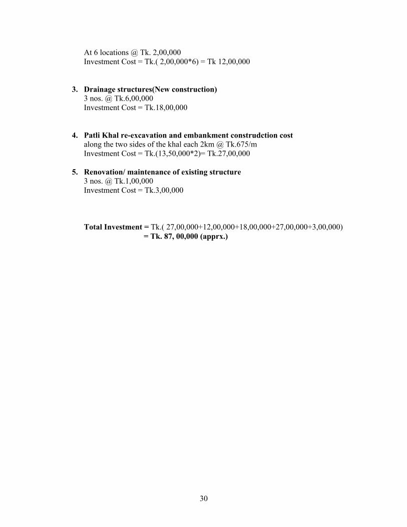
30
At 6 locations @ Tk. 2,00,000Investment Cost = Tk.( 2,00,000*6) = Tk 12,00,000
3. Drainage structures(New construction) 3 nos. @ Tk.6,00,000 Investment Cost = Tk.18,00,000
4. Patli Khal re-excavation and embankment construdction costalong the two sides of the khal each 2km @ Tk.675/mInvestment Cost = Tk.(13,50,000*2)= Tk.27,00,000
5. Renovation/ maintenance of existing structure3 nos. @ Tk.1,00,000Investment Cost = Tk.3,00,000
Total Investment = Tk.( 27,00,000+12,00,000+18,00,000+27,00,000+3,00,000) = Tk. 87, 00,000 (apprx.)
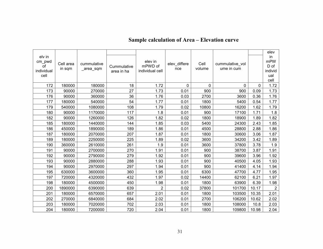
31
Sample calculation of Area – Elevation curve
elv in cm_pwd
of individual
cell
Cell area in sqm
cummulative_area_sqm
elev in mPWD of
individual cell
elev_difference
Cell volume
cummulative_volume in cum
elev in
mPWD of
individual cell
Cummulative area in ha
172 180000 180000 18 1.72 0 0 0 0 1.72173 90000 270000 27 1.73 0.01 900 900 0.09 1.73176 90000 360000 36 1.76 0.03 2700 3600 0.36 1.76177 180000 540000 54 1.77 0.01 1800 5400 0.54 1.77179 540000 1080000 108 1.79 0.02 10800 16200 1.62 1.79180 90000 1170000 117 1.8 0.01 900 17100 1.71 1.8182 90000 1260000 126 1.82 0.02 1800 18900 1.89 1.82185 180000 1440000 144 1.85 0.03 5400 24300 2.43 1.85186 450000 1890000 189 1.86 0.01 4500 28800 2.88 1.86187 180000 2070000 207 1.87 0.01 1800 30600 3.06 1.87189 180000 2250000 225 1.89 0.02 3600 34200 3.42 1.89190 360000 2610000 261 1.9 0.01 3600 37800 3.78 1.9191 90000 2700000 270 1.91 0.01 900 38700 3.87 1.91192 90000 2790000 279 1.92 0.01 900 39600 3.96 1.92193 90000 2880000 288 1.93 0.01 900 40500 4.05 1.93194 90000 2970000 297 1.94 0.01 900 41400 4.14 1.94195 630000 3600000 360 1.95 0.01 6300 47700 4.77 1.95197 720000 4320000 432 1.97 0.02 14400 62100 6.21 1.97198 180000 4500000 450 1.98 0.01 1800 63900 6.39 1.98200 1890000 6390000 639 2 0.02 37800 101700 10.17 2201 180000 6570000 657 2.01 0.01 1800 103500 10.35 2.01202 270000 6840000 684 2.02 0.01 2700 106200 10.62 2.02203 180000 7020000 702 2.03 0.01 1800 108000 10.8 2.03204 180000 7200000 720 2.04 0.01 1800 109800 10.98 2.04

32
205 360000 7560000 756 2.05 0.01 3600 113400 11.34 2.05206 270000 7830000 783 2.06 0.01 2700 116100 11.61 2.06207 270000 8100000 810 2.07 0.01 2700 118800 11.88 2.07208 90000 8190000 819 2.08 0.01 900 119700 11.97 2.08209 540000 8730000 873 2.09 0.01 5400 125100 12.51 2.09210 360000 9090000 909 2.1 0.01 3600 128700 12.87 2.1211 180000 9270000 927 2.11 0.01 1800 130500 13.05 2.11212 180000 9450000 945 2.12 0.01 1800 132300 13.23 2.12213 90000 9540000 954 2.13 0.01 900 133200 13.32 2.13214 180000 9720000 972 2.14 0.01 1800 135000 13.5 2.14215 180000 9900000 990 2.15 0.01 1800 136800 13.68 2.15216 180000 10080000 1008 2.16 0.01 1800 138600 13.86 2.16217 270000 10350000 1035 2.17 0.01 2700 141300 14.13 2.17

33
Appendix D
Day Report – 1Date- 21-03-2008
Activities:1. At 9:00 am - A brief Discussion on Bakhkhali Rubber Dam with Mr. Musarraf
Hossain, Socio-economist, LGED.
2. Interview with block manager of Chander para (Near dam)
3. Discussion with near dam farmers (FGD)
4. Interview with Mr. Moulana Abdul Gafur, Ex-chairmen
5. Interview with Mr. Mostafa, WMCA Secretary
Findings:
After introduction and brief Discussion on Bakhkhali Rubber Dam with Mr. Musarraf
Hossain, Socio-economist, LGED, we started for field visit. He guided us in the field and
introduced with different stakeholder.
Interview with block manager of Chander para
Coverage area increased and getting enough water for irrigation in near dam area
after construction of dam.
Each year there is huge loss of crops and especially vegetables in near dam area
due to inundation.
30 kani of land is inundated approximately each year.
Flooding occurs every year.
Damage crops due to inundation are vegetables and spices which are more
profitable.
Causes of flooding
o Inflation of rubber dam to its desired level causes inundation in the near
dam area approximately (2 acers).
o Opening of drainage outlets (Chhora) from low lying beel areas.
o Due to excess rainfall during irrigation period.

34
o Malfunctioning of rubber dam it self.
During the design period they had been assured that an embankment will be
constructed to prevent inundation in the near dam areas. But which was not
constructed later.
There is no complain on water shortage in the upstream area.
Suggestion to solve the near dam inundation problem:
o Construction of flood embankment up to Banglabazar Bridge.
o Construction of regulators on off-take canals.
o The selection of WMCA members should be proper.
Focus Group Discussion (FGD) with near dam farmers
They get enough water for irrigation
Flooding do not occur every year
Flood water stays maximum for one month
Damage crops due to inundation are vegetables and spices which are more
profitable.
Generally there is nominal loss of paddy due to flooding
Due to flooding they lose the investment cost of 7,000 to 8,000 Tk. per Kani and
economic value of destroyed crops is 12,000 to 15,000 Tk.
Embankment will be washed away if constructed along the river bank
Causes of flooding
o Inflation of rubber dam to its desired level causes inundation in the near
dam area approximately
o Opening of drainage outlets (Chhora) from low lying beel areas.
o Due to excess rainfall during irrigation period.
o Malfunctioning of rubber dam it self
Suggestion to solve the near dam inundation problem:
o Construction of regulators on off-take canals.
35
o The WMCA members can resolve the conflict through proper
initiative.
Interview with Mr. Moulana Abdul Gafur, Ex-chairmen
There is no complain on water shortage in the upstream area.
Causes of flooding
o Inflation of rubber dam to its desired level causes inundation in the near
dam area approximately 2 acres.
o last year delayed closing of drainage outlets (Chhora) from low-lying beel
areas caused flood
Suggestion to solve the near dam inundation problem:
o Construction of closures on off-take canals in due time
o Proper management of Rubber Dam
Interview with Mr. Mostafa, WMCA Secretary (Block Manager)
Damage crops due to inundation are vegetables and spices which are more
profitable.
Generally there is nominal loss of paddy due to flooding
There is no point to consider loss of only 2acres of crops to provide irrigation on
more than 1,000 acres of additional land
Due to political influences they had to lower the dam in previous years which
cause water shortages in the whole project area.
They were not consulted during project implementation phase
They give proper announcement about dam inflation time so that people can close
the small openings and WMCA is responsible for closing the larger openings
There are enough funds in the Govt. sectors but no efforts have been given to
construct the flood embankment.
Causes of flooding
o Inflation of rubber dam to its desired level causes inundation in the near
dam area approximately (2 acers).
o Opening of drainage outlets (Chhora) from low lying beel areas.

36
o Due to excess rainfall during irrigation period.
o Malfunctioning of rubber dam it self.
Suggestion to solve the near dam inundation problem:
o Construction of flood embankment up to Banglabazar Bridge.
o Construction of regulators on off-take canals.
o Construction of flood embankment on the bank of Patila Khal.
Day Report – 2Date- 22-03-2008
Activities:
1. Review of Draft proposal and discussion on Day Report-1
2. Interview with Monir Ahmed Chowdhury, Ex-UP Member, Rajarkul
3. Discussion with upstream farmers (FGD), Dangpara, Rajarkul
4. Discussion with upstream farmers (FGD), Nayapara, Fotekharpul
5. Interview with Mostafizur Rahman Kajol, Nayapara, Fotekharpul
6. Interview with Fayezullah, Line Man, Kalghar Bazar, Paschim Chakmarpul
Findings:
After discussion on the draft proposal with the teachers and resource person Dr. Hamidul
Haque, we started for field visit towards the upstream project boundary.
Interview with Monir Ahmed Chowdhury, Ex-UP Member, Rajarkul After construction of Rubber dam their crop production has increased. Coverage
area has increased and getting enough water for irrigation in upstream area.
Each year there is a loss of crops in 10 percent of the farmers having land in the
low lying areas due to inundation.
They get enough water for irrigation if the water level is maintained as in this
year.
If they get less supply from Rubber dam, then they construct an earthen dam just
at the downstream of their boundary near Chakmarpul, store the seepage water
from upstream and use the water for irrigation.

37
In case of excess water they inform the Chairman to deflate the dam.
During the design period, they were not consulted.
Causes of water shortage:
o Lowering of the Rubber dam than the desired level
o Delayed inflation of dam.
o Presence of excess pumps on the upstream of project boundary.
o Construction of small earthen embankments across the upstream hilly
Chharas.
o Malfunctioning of rubber dam it self.
Suggestion to solve their problems:
o To maintain the water level as in this year.
o Construction of regulators on off-take canals.
o Timely inflation of the Rubber dam as in this season(18th December’ 07)
Discussion with upstream farmers (FGD), Dangpara, Rajarkul After construction of Rubber dam their crop production has increased. Coverage
area increased and getting enough water for irrigation in upstream area.
Each year there is a loss of crops in near dam area due to inundation but the losses
are very small compared to their benefits.
They get enough water for irrigation if the water level is maintained as in this
year.
If they get less supply from Rubber dam, then they collect stored water from
seven hilly Chharas.
Their irrigation will not be hampered if the water level falls further 0.3m to 0.5m.
Farmers just immediate downstream of their area suffer from water shortage, if
the dam height is lowered.
They are not the members of WMCA although their area lies in the project area.
Suggestion to solve their problems:
o To maintain the water level as in this year.

38
Discussion with upstream farmers (FGD), Nayapara, Fotekharpul There is a clear conflict between the Kathuria doba high land farmers and
Nayapara low lying area farmers.
After construction of Rubber dam their crop production has increased in the high
land areas and getting enough water for irrigation whereas the low lying areas are
suffering from inundation and loss their crops.
They have no control structures on the off-taking channels.
Their irrigation will not be hampered. if the water level falls further 0.3m.
They get enough water for irrigation, if the water level is maintained as in this
year.
They are not the members of WMCA although their area lies in the project area.
They informed the Officials and local public representatives but their problem are
not resolved yet.
Suggestion to solve their problems:
o To maintain the water level as in this year.
o Construction of earthen dams/ control structures at the mouth of the off-
taking channels.
Interview with Mostafizur Rahman Kajol, Nayapara, Fotekharpul After construction of Rubber dam their crop production has increased. Coverage
area increased and getting enough water for irrigation in upstream area.
Each year there is a shortage of water at the end of irrigation period.
They get enough water for irrigation, if the water level is maintained as in this
year.
During the design period, they were not consulted.
They have some inundation problem approximately over 1 don (don = 16 kani, 1
kani = 40 dicimile) area.
If the water level in the dam is lowered further then they won’t be able to pump
any water for irrigation during March which is a crucial time for irrigation.
Timely inflation of the Rubber dam as in this season (18th December’ 07) ensured
sufficient water supply for irrigation.
Causes of water shortage:

39
o Lowering of the Rubber dam lower than the desired level.
o Delayed inflation of dam.
o Malfunctioning of rubber dam it self.
Suggestion to solve their problems:
o To maintain the water level as in this year.
o Timely inflation of the Rubber dam as in this season (18th December’ 07).
Interview with Fayezullah, Line Man, Kalghar Bazar, Paschim Chakmarpul near Block No. 75, 76 & 77 (mid stream).
They get enough water for irrigation.
They are not affected by the lowering of the dam height.
Day Report – 3Date- 23-03-2008
Activities:
7. Discussion on Day Report-2 and final reporting format.
8. Interview with Shaikh Muzakka Zaher, Executive Engineer, LGED, Cox’s Bazar
9. Interview with Md. Nurul Alam , Chairmen, WMCA
10. Interview with Md. Yusof Bhuiyan, Upazilla Agriculture Officer, Cox’s Bazar
and associates.
11. Interview with Mr.Imam Shorif, UP member, Piamkhali.
12. Interview with Mr. Shamsul Alam, Jhilongjha Union.
13. Interview with Mr. Abdur Rahim, Chairmen, Piamkhali
Findings:
Interview with Shaikh Muzakka Zaher, Executive Engineer, LGED, Cox’s Bazar
After construction of Rubber dam crop production has increased. Actual
Coverage area is more than expectation.
WMCA of Bakkhali rubber dam project is not functioning properly.

40
Because of large coverage area with 2 upazilla and 5 unions it has become hard
for WMCA to control the project area. Political problem also hampering the
activities of WMCA.
There is inundation problem in near dam area due to inflation of dam.
If there is any conflict in the project it should be informed to LGED through
WMCA. In that case LGED will try to solve the problem with the revenue budget
allocated each for the project maintenance.
WMCA is avoiding conflict resolution committee.
Suggestion to solve their problems:
o WMCA should perform properly to solve the conflicts in the area.
Interview with Md. Nurul Alam, Chairman, WMCA
After construction of Rubber dam their crop production has increased. Coverage
area increased and getting enough water for irrigation in upstream area.
Each year there is a loss of rabi crops in near dam area due to inundation but the
losses are very small compared to their benefits. Approximately 2-4 acres land
gets inundated.
Farmers are now bound to produce paddy instead of Rabi crops. Farmers are not
happy with this situation.
Dam can be inflated up to 3 m and now it is 2m inflated.
The dam is deflated slowly with the lowering of water level.
During design period farmers of low land was ensured to compensate for
inundation. But measures are not taken as the area is very small.
People of Razarkul are not member of WMCA. Because they are reluctant to pay
the fees of WMCA.
Extreme upstream do not face any water shortage as have enough water from hilly
Chharas.
WMCA is not functioning properly because of following reasons:
o Lack of communication among members of WMCA.
o Political conflicts.

41
o Block manager do not pay charges properly for this savings of WMCA is
very small.
Suggestion to solve their problems:
o Embankment up to Banglabazar Bridge with sluice gate.
o Khola khal, Noya khal and Pera khal in Chanderpara needs sluice gate.
Interview with Md. Yousuf Bhuiyan, Upazilla Agriculture Officer, Cox’s Bazar
and associates
After construction of Rubber dam crop damaged happens in approximately 4
percent of land.
Irrigable areas are 72.79% of total command area (6000ha).
Mostly the people prepare their seedbed in the lower part of the basin. So during
inflation of the Rubber dam seedbeds are damaged.
Price of rice is approximately 18 taka per kg.
Paddy production per hectare is approximately 500 kg.
If Rubber dam is inflated in the first quarter of December then water for irrigation
will be available throughout the irrigation period or else there will be water
shortage.
In Inundated area crops are transplanted at a later stage and the farmers looses
approximately 15 percent of crop yield.
Stakeholders come to them for technical suggestions but they are not invited in
the WMCA meeting.
Suggestion to solve the conflict:
o The present conflict can be solved through crop diversification, viz- if
spinach is cultivated instead of spices and vegetables then they can
harvested before the dam is inflated.
o WMCA meetings should be held regularly.
o The seedbeds can be protected by opening the gates of Mantargoda and
Guillarchari regulators by draining out the excess water.
o The seedbeds can be prepared on a higher ground so that they are not
inundated.

42
Interview with Mr.Imam Shorif, UP member, Piamkhali
To give benefit to a larger area crop damage in a small patch of land should be
sacrificed
Suggestions to solve the conflict:
o Those who have lost their crops due to inundation can be compensated by
the beneficiaries.
o In the inundated areas fish cultivations can be done instead of crops.
o The crop damage in the low lying areas can be minimized by constructing
closure on the off-taking channels and providing drainage canals with
control gates at downstream.
Interview with Mr. Shamsul Alam, Jhilongjha Union
There is no problem in Jhilongjha union.
After construction of Rubber dam their crop production has increased. Coverage
area increased and getting enough water for irrigation in upstream area.
Interview with Mr. Abdur Rahim, Chairman, Piamkhali
If Rubber dam is inflated in the first quarter of December then water for irrigation
will be available throughout the irrigation period or else there will be water
shortage.
To give benefit to larger area, crop damage in a small patch of land should be
sacrificed.
Day Report – 4Date- 24-03-2008
Activities:
6. Discussion with affected near dam farmers (FGD)
7. Discussion with affected near dam Housewives (FGD)
8. Interview with UNO, Cox’s Bazar.
Findings:
Discussion with affected near dam farmers (FGD)

43
The inundation problem was also being experienced before the Rubber dam
placing but not as severe as prior dam placing.
The inundation is causing damages to the heavily profitable vegetables each year.
The WMCA President does not respond to the local people’s need.
50 don land near the Rubber dam usually got inundated each year.
It was told by the Authority that dykes on both the banks will be constructed to
avoid the inundation due to Rubber dam.
Stakeholders are preparing their seedbeds on relatively higher ground to avoid
inundation due to full inflation of Rubber dam.
There is bank erosion in left side of Bakkhali River.
Causes of flooding
o Inflation of rubber dam to its desired level causes inundation in the near
dam area approximately (2 acres).
o Opening of drainage outlets (Chora) from low lying beel areas.
o Due to excess rainfall during irrigation period.
o Malfunctioning of rubber dam it self.
During the design period they had been assured that an embankment will be
constructed to prevent inundation in the near dam areas. But which was not
constructed later.
There is no complain on water shortage in the upstream area.
Suggestion to solve the near dam inundation problem:
o Construction of dykes on both banks up to Banglabazar Bridge.
o Construction of regulators on off-take canals.
o The selection of WMCA members should be proper.
Discussion with affected near dam Housewives (FGD)
They get enough water for irrigation.
Flooding occurs every year.
Those who have high land are being more benefited than those who have low land
near the dam.

44
When the field becomes inundated due to inflation of rubber dam, local people
requested WMCA to lower the dam a bit but no measure had been taken.
Damaged crops due to inundation are cauliflower, cabbage, potato and chili which
are more profitable. Cauliflower, cabbage and rice are highly profitable crops.
Due to inundation crops are required to be planted twice or thrice in a season. So
they suffer a great loss.
Due to inundation, the stagnant water in the fields causes mosquito problem and
cattle suffer from Pneumonia.
Causes of flooding:
o Inflation of rubber dam to its desired level causes inundation in the near
dam area.
o Opening of drainage outlets (Chhora) from low lying beel areas.
Suggestion to solve the near dam inundation problem:
o Construction of regulators on off-take canals.
o When the fields are inundated, lowering the dam height for a small period
of time can solve the problem.
o Construction of flood embankment.
Interview with UNO, Cox’s Bazar
He has joined the Cox’bazar Upazilla recently (six months)
He deals with the Bakkhali Rubber Dam issue jointly with Ramu UNO.
He has received some complains about Rubber dam operation from both upstream
and downstream.
Some people try to pursue him for getting the control of Block Management.
He has some plan to do something about the sufferers either by compensating or
by taking some technical measures.
Suggestion to solve the problem:
o Expecting the research report from BUET for being more informed.

45
Appendix – E
Discussion with near dam farmers
Discussion with near dam affected farmers.

46
Discussion with upstream farmers.
Interview with WMCA Secretary