access to research data - oceanteacher
TRANSCRIPT

OTGA: Research Data Management
IOC/IIOE2-OTGA and IORA Joint Training Course: Research Data Management 22-26 May 2016: Kuala Terengganu, Malaysia
Hosted by: Government of Malaysia and Malaysian Ocean Teacher Global Academy (OTGA) Regional Training Centre (RTC), INOS, UMT Supported by: Australian Aid, UNESCO/IOC Perth Programme Office, UNESCO/IOC Project Office for International Oceanographic Data and
Information Exchange (IODE) and the Indian Ocean Rim Association (IORA)
Access to research data
Greg Reed IOC Consultant

OTGA: Research Data Management
• Research data is information generated by scholarly projects through experiments, measurements, surveys or interviews
• A data repository provides long-term storage and access to research data through: • a data provider that offers research data and its metadata
exposed via interfaces; or • a service provider (e.g. a portal) that can harvest the
metadata of research data from data providers to build value-added services
INTRODUCTION

OTGA: Research Data Management
Review of access to data through global, regional and thematic portals • World Ocean Database (WOD) • Ocean Biogeographic Information System (OBIS) • Integrated Marine Observing System (IMOS)
DATA PORTALS

OTGA: Research Data Management
WORLD OCEAN DATABASE

OTGA: Research Data Management
• The World Ocean Database represents the world’s largest collection of ocean profile and plankton data available internationally without restriction.
• Data is submitted from • IODE National Oceanographic Data Centres • International Ocean Observing Projects such GTSPP, Argo • International Ocean Data Management Projects such as the
IOC/IODE Global Oceanographic Data Archaeology and Rescue Project (GODAR)
WORLD OCEAN DATABASE

OTGA: Research Data Management
• WOD 2013 contains nearly 13 million temperature profiles and 6 million salinity measurements
• Historical records date as far back as 1773 • WOD maintained by NOAA
WORLD OCEAN DATABASE 2013
NOAA Photo Library

OTGA: Research Data Management
WOD consists of eleven data collections: • Ocean Station Data (OSD) [Bottle or Nansen cast, low resolution
CTD/XCTD, plankton data] • High Resolution CTD/XCTD (CTD) • Expendable Bathythermograph (XBT) • Mechanical Bathythermographs (MBT) [includes Digital
Bathythermograph, µBT] • Profiling Floats (PFL) • Drifting Buoys (DRB) • Moored Buoys (MRB) [TAO, PIRATA, others] • Autonomous Pinniped Bathythermographs (APB) • Undulating Oceanographic Recorder (UOR) [Towed CTD] • Surface-Only (SUR) [Bucket, Thermosalinograph] • Glider data (GLD)
WOD DATASETS

OTGA: Research Data Management
• The WODselect retrieval system allows a user to search World Ocean Database 2013 using a user-specified search criteria.
• A distribution map and cast count of these search criteria will give the user the option to have the data extracted and placed on the NOAA/NODC FTP site.
https://www.nodc.noaa.gov/OC5/SELECT/dbsearch/dbsearch.html
ACCESS TO WOD

OTGA: Research Data Management
• Options:
WODSELECT

OTGA: Research Data Management
WOD DATA DOWNLOAD OPTIONS

OTGA: Research Data Management
• In oceanography standard levels, or depths, are used in climatologies as the depths of the variables to be analyzed
• WOD2013 has extended the 40 standard depth levels used in previous versions of WOD to 137 standard depth levels
STANDARD DEPTHS
Depth Level Depth Level Depth Level
0 1 55 12 150 23
5 2 60 13 175 24
10 3 65 14 200 25
15 4 70 15 225 26
20 5 75 16 250 27
25 6 80 17 275 28
30 7 85 18 300 29
35 8 90 19 325 30
40 9 95 20 350 31
45 10 100 21 375 32
50 11 125 22 400 33 Etc. …

OTGA: Research Data Management
• A standard set of climatological analyses, based on the WOD, has been developed, called the World Ocean Atlas (WOA).
• The WOA consists of objectively analyzed global grids, at standard depths of the following marine parameters: • Temperature • Salinity • Dissolved oxygen • Apparent oxygen utilisation (AOU) • Percent oxygen saturation • Phosphate • Silicic acid • Nitrate
WORLD OCEAN ATLAS

OTGA: Research Data Management
• Annual temperature, ¼ degree, surface
• January salinity, ¼ degree, surface
• Annual dissolved oxygen, 1 degree, 500m depth
WORLD OCEAN ATLAS - EXAMPLES

OTGA: Research Data Management
OCEAN BIOGEOGRAPHIC INFORMATION SYSTEM

OTGA: Research Data Management
• Ocean Biogeographic Information System (OBIS) is an alliance of people and organizations sharing a vision to make global marine biogeographic data freely available
• OBIS was originally created as the data integration component of the Census of Marine Life (CoML) 10 year program
• OBIS is now a program of the Intergovernmental Oceanographic Commission’s IODE programme
OBIS: INTRODUCTION
OTGA: Research Data Management
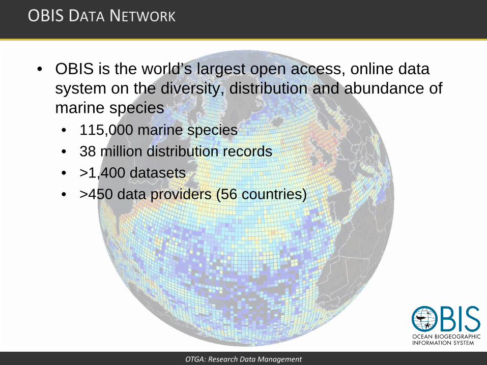
• OBIS is the world’s largest open access, online data system on the diversity, distribution and abundance of marine species • 115,000 marine species • 38 million distribution records • >1,400 datasets • >450 data providers (56 countries)
OBIS DATA NETWORK
OTGA: Research Data Management
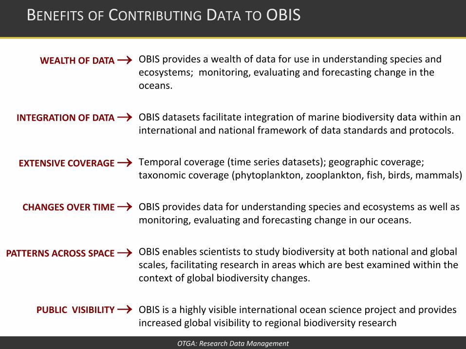
OBIS provides a wealth of data for use in understanding species and ecosystems; monitoring, evaluating and forecasting change in the oceans. OBIS datasets facilitate integration of marine biodiversity data within an international and national framework of data standards and protocols. Temporal coverage (time series datasets); geographic coverage; taxonomic coverage (phytoplankton, zooplankton, fish, birds, mammals) OBIS provides data for understanding species and ecosystems as well as monitoring, evaluating and forecasting change in our oceans. OBIS enables scientists to study biodiversity at both national and global scales, facilitating research in areas which are best examined within the context of global biodiversity changes. OBIS is a highly visible international ocean science project and provides increased global visibility to regional biodiversity research
BENEFITS OF CONTRIBUTING DATA TO OBIS
WEALTH OF DATA →
INTEGRATION OF DATA →
EXTENSIVE COVERAGE →
CHANGES OVER TIME →
PATTERNS ACROSS SPACE →
PUBLIC VISIBILITY →

OTGA: Research Data Management
Regional OBIS Nodes (RONs) include: • Antarctica: AntOBIS. Belgian Biodiversity Platform, Belgium • Arctic: ArcOD. University of Alaska Fairbanks - School of Fisheries and Oceans, Alaska • Argentina: ArOBIS. Centro Nacional Patagónico (CENPAT) CONICET • Australia: OBIS-Australia. Commonwealth Scientific and Industrial Research Organisation (CSIRO) • Canada: OBIS-Canada. Centre of Marine Biodiversity, Bedford Institute of Oceanography • Caribbean Sea: Caribbean OBIS, Univ. Simón Bolívar, Venezuela • China: OBIS-China. Institute of Oceanology, Qingdao • Europe: EurOBIS. Vlaams Instituut voor de Zee (VLIZ) Belgium • Indian Ocean: IndOBIS. Centre for Marine Living Resources and the Environment, India • Japan: OBIS-Japan. Japan agency for Marine-Earth Science and Technology • Korea: KOBIS. Korea Ocean Research & Development Institute • Mediterranean: MedOBIS. Hellenic Centre for Marine Research, Greece • Persian Gulf & Gulf of Oman: PEGO-OBIS. Iranian National Institute for Oceanography (INIO), Iran • Senegal: OBIS Senegal. Centre De Recherches Océanographiques Dakar-Thiaroye (C.R.O.D.T) • South-East Asia: SEAOBIS. ASEAN Centre for Biodiversity, Philippines • South-West Pacific: South Western Pacific OBIS. NIWA, New Zealand • Sub-Saharan Africa: AfrOBIS. Southern African Data Centre for Oceanography, South Africa • Tropical and Subtropical Eastern South Pacific: ESPOBIS. FONDAP COPAS, Chile • Tropical and Subtropical Western South Atlantic: WSAOBIS. University of São Paulo, Brazil • Ukraine: Institute of Biology of the Southern Seas of National Academy of Sciences of Ukraine • USA: OBIS-USA.
OBIS REGIONAL NODES

OTGA: Research Data Management
• OBIS allows users to search marine species datasets from all the world's oceans.
OBIS DATA PORTAL
Observation data associated with Bottom depth Temperature Salinity Nitrogen / Oxygen Phosphate / Silicate
Visualized through interactive graphs Time-series graphs Histograms

OTGA: Research Data Management
• Select observations based on environmental conditions
OBIS DATA PORTAL
Example map 1 Cetacean species observations in LME region ‘Celtic-Biscay Shelf’ (no environmental conditions set)
Example map 2 Cetacean species observations in LME region ‘Celtic-Biscay Shelf’ filtered by a temperature range of 13 to 15 degrees

OTGA: Research Data Management
HOW TO FIND OBIS DATA

OTGA: Research Data Management
Or watch the video … http://www.iobis.org/mapper/contents/tutorials/basic_search_demo.htm
HOW TO FIND OBIS DATA

OTGA: Research Data Management
• The OBIS data policy is based on the principles of timely, free and unrestricted access to biodiversity data for the benefit of science and society, as defined in the: • IOC data exchange policy • IOC guidelines on transfer of marine technology • IODE objectives • OBIS vision and mission
• Unless data are collected through activities funded by IOC/IODE, neither UNESCO, IOC, IODE, the OBIS Secretariat, nor its employees or contractors, own the data in OBIS and they take no responsibility for the quality of data or products based on OBIS, or the use or misuse that people may make of them nor can it control or limit the use of any data or products accessible through its website, other than through the use of a published Data Sharing and Use Terms and Conditions.
OBIS DATA POLICY

OTGA: Research Data Management
• The data providers retain all rights and responsibilities associated with the data they make available to OBIS via the OBIS nodes.
• The OBIS nodes warrant that they have made the necessary agreements with the original data providers that it can make the data available
• OBIS data is licensed under the following Creative Commons licences CC-0 or CC-BY or CC-BY-NC • CC-0 is the preferred one and CC-BY-NC the least preferred.
OBIS DATA SHARING

OTGA: Research Data Management
• CC0 enables scientists, educators, artists and other creators and owners of copyright- or database-protected content to waive those interests in their works and thereby place them in the public domain, so that others may freely build upon, enhance and reuse the works for any purposes without restriction under copyright or database law.
• The person who associated a work with this deed has dedicated the work to the public domain by waiving all of his or her rights to the work worldwide under copyright law.
• You can copy, modify, distribute and perform the work, even for commercial purposes, all without asking permission.
CC0 — “NO RIGHTS RESERVED”

OTGA: Research Data Management
• This license lets others distribute, remix, tweak, and build upon your work, even commercially, as long as they credit you for the original creation.
• This is the most accommodating of licenses offered. Recommended for maximum dissemination and use of licensed materials.
• You are free to: • Share — copy and redistribute the material in any medium or
format • Adapt — remix, transform, and build upon the material for
any purpose, even commercially.
CC-BY — ATTRIBUTION

OTGA: Research Data Management
• This license lets others remix, tweak, and build upon your work non-commercially, and although their new works must also acknowledge you and be non-commercial, they don’t have to license their derivative works on the same terms.
• You are free to: • Share — copy and redistribute the material in any medium or
format • Adapt — remix, transform, and build upon the material
CC-BY-NC — ATTRIBUTION-NON COMMERCIAL

OTGA: Research Data Management
• Data providers are responsible for the completeness of the data and metadata profiles. When data is made available to OBIS, OBIS is granted permission to: • Distribute the data via its data and information portal at
www.iobis.org, • Build an integrated database, use the data for data quality
control purposes, complement the data with other data such as climate variables and build value-added information products and services for science and decision-making,
• Serve the data to other similar open-access networks such as GBIF in compliance with the terms and conditions for use set by the data providers.
OBIS DATA SHARING

OTGA: Research Data Management
INTEGRATED MARINE OBSERVING SYSTEM

OTGA: Research Data Management
• IMOS is a national, collaborative, research infrastructure, funded by Australian Government
• It provides the means for multiple institutions to undertake sustained observing of the marine environment
• Making all of the data openly available for research and other purposes
• IMOS is integrated from the open ocean, onto the shelf and into the coast, across physics, chemistry, and biology
INTEGRATED MARINE OBSERVING SYSTEM

OTGA: Research Data Management
• IMOS has been designed to address big science questions posed through a series of Nodes, which bring together the research community and the stakeholders
• It has been implemented through a portfolio of technologies and platforms, called Facilities, which are operated by multiple Institutions
• All of the Data is open access, made available though a single national marine information infrastructure called the Australian Ocean Data Network (AODN)
HOW DOES IMOS WORK?

OTGA: Research Data Management
• Australian marine and climate science community organised into ‘Nodes’
• Bluewater and Climate Node • (white box on map) • Limits of EEZ , regional climate
• Regional Coastal Nodes • (black lines on map) • Five Regional Nodes • Collectively covering Australia’s
shelf and coastal oceans
IMOS NODES

OTGA: Research Data Management
1. Argo Floats 2. Ships of Opportunity 3. Deepwater Moorings 4. Ocean Glider Fleet 5. Autonomous Underwater Vehicles 6. National Mooring Network 7. Ocean Radar Network 8. Animal Tagging and Monitoring Network 9. Wireless Sensor Network 10. Satellite Remote Sensing
IMOS FACILITIES

OTGA: Research Data Management
• The Data Facility works with other components of IMOS • Making all data discoverable, accessible and usable via the
AODN Ocean Portal • https://imos.aodn.org.au/imos123/
• Not ‘just another portal’... • An integrated infrastructure encompassing data, middleware,
standards, access, and discovery • AODN Ocean Portal follows international standards and
agreements for data/metadata, discovery and sharing.
IMOS DATA

OTGA: Research Data Management
DATA DISCOVERY PORTAL

OTGA: Research Data Management
METADATA CATALOGUE
OTGA: Research Data Management
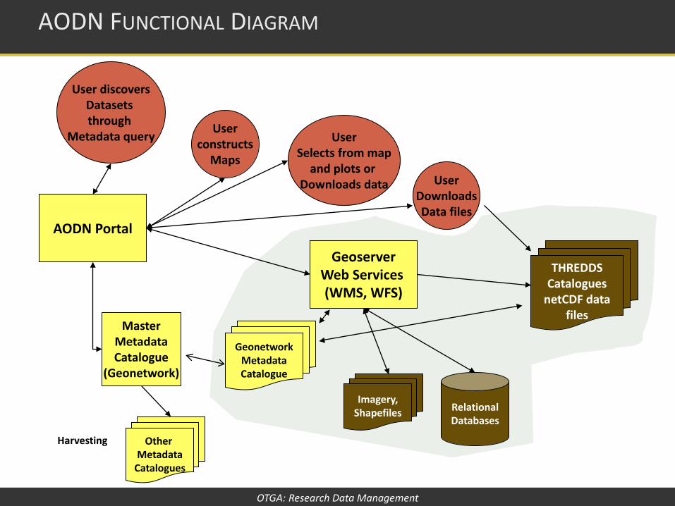
AODN FUNCTIONAL DIAGRAM
Master Metadata Catalogue
(Geonetwork)
AODN Portal
Geoserver Web Services (WMS, WFS)
User Downloads Data files
Other Metadata
Catalogues
Harvesting
User constructs
Maps
User Selects from map
and plots or Downloads data
Relational Databases
THREDDS Catalogues
netCDF data files
Imagery, Shapefiles
User discovers Datasets through
Metadata query
Geonetwork Metadata Catalogue

OTGA: Research Data Management
Marine research sectors • Government, universities, private industry, not-for-profit
organisations Marine science disciplines • Physical and chemical oceanography, biology,
biogeochemistry, modelling Marine data sources • Observation data, model output, data products Marine data delivery • Real-time (e.g. tide gauges, tsunami buoys), delayed mode,
archived / historic Marine data formats • Gridded data (e.g. satellites, HF radar), image data, time
series
DATA DIVERSITY IN THE AODN

OTGA: Research Data Management
Example: • OceanCurrent
• http://oceancurrent.imos.org.au/
• Daily maps • Surface currents • Temperature • Ocean Colour
• Better use of data streams • Making ocean data available to a
wider audience
ADDING VALUE TO DATA

OTGA: Research Data Management
• Data provided to AODN is unencumbered, i.e. it is freely accessible
• Data is documented with metadata • ISO 19115 standard metadata • Metadata hosted by participating agencies
• All data is publicly available and licenced through Creative Commons BY licence
• Result: Increase discoverability, access and re-use of marine data
IMOS DATA POLICY

OTGA: Research Data Management
World Ocean Database 2013 https://www.nodc.noaa.gov/OC5/WOD13/
OBIS
http://www.iobis.org/
AODN Data Portal https://imos.aodn.org.au/imos123/
REFERENCES