a world of - unescounesdoc.unesco.org/images/0014/001463/146393e.pdf · microscopic algae which...
TRANSCRIPT

IN THIS ISSUE EDITORIAL
IN FOCUS
2 The red tide
NEWS
8 A science policy for Lebanon
9 Kit helps kids discover drylands
9 Humans bigger danger for coral reefs than tsunami
10 UNESCO Chair in Earth sciences for Nigeria
11 Federation of African Societies of Chemistry founded
12 UNESCO condems terror campaign against Iraqi academics
12 Pacific tsunami warning system put to the test
13 African World Heritage Fund launched
INTERVIEW
14 Hans van Ginkel presents a think-tank within the United Nations
HORIZONS
17 Using the sun to quench their thirst
19 Saviours from space for Siberia's frozen tombs
IN BRIEF
24 Diary24 New releases
Natural Sciences Quarterly Newsletter
Vol. 4, No. 3July – September 2006
A World of
Saving lost civilizationssk people to name UNESCO’s greatest triumph in its 60 years of existence and how many would say, ‘Abu Simbel’? In the late 1950s, the plight of these 3000-year old
temples captured the public imagination. Abu Simbel and 22 other Nubian temples and tombs were in danger of disappearing beneath the waters of Lake Nasser, a reservoir cre-ated by the construction of the Aswan High Dam. The Governments of Egypt and Sudan appealed to UNESCO for help. UNESCO responded by organizing the most vast inter-national campaign ever to safeguard archaeological heritage.
Moving the Nubian temples would demand great ingenuity. The beautifully sculpted temples had to be cut into stone blocks and numbered prior to being transported and reassembled, like pieces in a jigsaw puzzle: 37 000 blocks for the Philae temples alone. Some of the sandstone at Abu Simbel was so friable that it had to be injected with synthetic resin to prevent it from crumbling under the saw. The cliff in which Abu Simbel was niched had to be removed and an artificial hillside constructed 180 m back from the original site on higher ground. Abu Simbel was still being dismantled when the waters began rising, send-ing engineers scuttling to erect a protective dam after an emergency geological survey.
The safeguard of the Nubian temples was a cultural triumph but equally a triumph of science and engineering. This was neither the first, nor the last, time that scientists and engineers had helped to preserve the memory of lost civilizations.
Methods have evolved, of course, since the 1960s. The development of satellite imagery, for instance, combined with fair use clauses permitting wide use of the tech-nology, has revolutionized such diverse fields as meteorology, ecology, physical oceano-graphy and ... archaeology.
UNESCO is currently using space technologies to help save another archaeological treasure, the frozen tombs of Siberia. These tombs offer rare insights into the lost Scythian culture. Preserved in permafrost for 2500 years, the tombs lie scattered across the Altai Mountains straddling China, Kazakhstan, Mongolia and Russia. They contain frozen bod-ies in such a remarkable state of conservation that even the tattoos on their skin are often intact.
In this issue, we follow the project’s progress since the US National Aeronautics and Space Agency (NASA) joined UNESCO and the European Space Agency in their Open Initiative to protect natural and cultural sites using space technologies. NASA is providing the University of Ghent in Belgium with the satellite imagery it needs to produce the first comprehensive map of the tombs and terrain.
As with Abu Simbel, the scientists are engaged in a race against time. Climate change is thawing the ground which has protected the tombs for so long. The conservationists from the four countries concerned need to know how fast the Altai’s glaciers are retreating to devise an effective strategy for saving the tombs. By monitoring climate change in the Altai, the project will also be providing them with these answers.
W. ErdelenAssistant Director-General for Natural Sciences
A
United Nations Educational, Scientific and Cultural Organization Saviours from space for
Siberia’s frozen tombs, p.19
AWOS_july06_imp_3july.indd 1 3/07/06 14:20:11

IN FOCUS
Of the 5000 species of marine phytoplankton, 300 can proliferate to such an extent that they discolour the surface of the sea, producing an impressive ‘red tide’ made up of millions of cells per litre of water. The microscopic algae which make up these blooms are a delicacy appreciated by oysters, mussels, scallops and clams. Moreover, as both shellfish and the larvae of crustaceans and finfish find microalgae a tasty morsel, red tides can be a veritable boon for aquaculture and wild fisheries.
In some situations, however, these spectacular algal blooms can turn into a nightmare, causing severe economic losses to aquaculture, fisheries and tourism, major environmental problems and health ‘epidemics’. Only 80 or so microalgal species may be able to produce toxins potent enough to find their way through fish and shellfish into humans but, for the victim of food poisoning, the consequences can be tragic.
Harmful blooms are becoming more frequent, more intense and more widespread. Researchers, industrialists, governments and local users will be meeting in Copenhagen (Denmark) from 4 to 8 September to exchange research findings and ideas on how to cope with this escalating problem, at a conference co-sponsored by UNESCO’s Intergovernmental Oceanographic Commission (IOC).
The red tide
Worldwide, close to 2000 cases of food poisoning from con-sumption of contaminated fish or shellfish are reported each year. Some 15% of cases will prove fatal. If not controlled, the economic damage through the slump in local consumption and exports of seafood products can be considerable.
Whales and porpoises can also become victims when they receive toxins through the food chain via contaminated zooplankton or fish. In the USA, poisoning of manatees in Florida via seagrasses and, in California, of pelicans and sealions via anchovies, has been reported.
A nuisance even in biblical times
One of the first recorded fatal cases of food poisoning after eating contaminated shellfish happened in 1793, when
English surveyor Captain George Vancouver and his crew landed in British Columbia (Canada) in an area now known as Poison Cove. He noted that, for local Indian tribes, it was taboo to eat shellfish when the seawater became biolumi-nescent due to algal blooms. The toxins involved, paralytic shellfish poisons (PSP), are so potent that a quantity the size of a pinhead (about 500 micrograms), which can easily accumulate in just a 100-gram serving of shellfish, can be fatal to humans.
It is believed that the first written reference (1000 years B.C.) to a harmful algal bloom appears in the Bible: 'All the waters that were in the river were turned to blood. And the fish that was in the river died; and the river stank, and the Egyptians could not drink of the water of the river' (Exodus 7: 20–21). In this case, a non-toxic alga became so densely concentrated that it depleted the oxygen in the water, thereby suffocating both fish and invertebrates. Non-toxic algal blooms can thus be devastating for local eco-systems, not to mention scaring away tourists confronted with unsightly dead floating fish, slime and foam.
Harmful algal events on the rise
Harmful algal blooms are completely natural phenomena which have occurred throughout recorded history but, in the past two decades, they seem to have become more frequent, more intense and more widespread. PSP, for example, was only known in temperate waters of Europe, North America and Japan until 1970. Twenty years later, PSP was well-documented throughout the Southern Hemisphere, in South Africa, Australia, New Zealand, India, Thailand,
Noctiluca scintillans is the culprit which caused this spectacular, if harmless, ‘red tide’ in the Seto Inland Sea in
1976. Red tides are a frequent occurrence along the coast of Japan Phot
o co
urte
sy o
f Sui
san
Avi
atio
n, J
apan
Aerial and ground views of a megascale shrimp farm in Indonesia made up of 18 000 ponds
© W
estp
ac/U
NE
SCO
-IO
C
IN FOCUS
A World of SCIENCE, Vol. 4, No. 3, July – September 2006 3A World of SCIENCE, Vol. 4, No. 3, July – September 20062
AWOS_july06_imp_3july.indd 2 3/07/06 14:20:12
IN FOCUS
Brunei, Sabah, the Philippines and Papua New Guinea. It is unfortunate that so few long -term records of algal blooms at any single locality exist.
Four explanations for this apparent increase in algal blooms have been proposed: a greater scientific awareness of toxic species; the growing utilization of coastal waters for aquaculture; the stimulation of plankton blooms by domestic, industrial and agricultural wastes and/or unusual weather conditions; and the transportation of algal cysts either in ships’ ballast water or associated with moving shellfish stocks from one area to another.
Know thine enemy
Reports of harmful algal blooms, associated human ill-nesses or damage to aquaculture operations, are receiving growing attention in newspapers, the electronic media and scientific literature. As a result, more and more research-ers are now surveying their local waters for the algal culprits.
Since diarrhetic shellfish poisoning (DSP) was first documented in 1976 from Japan, where it caused major problems for the scallop fishery and provoked 1300 cases of food poisoning in six years, other outbreaks have been reported: more than 5000 cases in Spain in 1981 and a further 3300 cases in France in 1983. In 1984, DSP caused a shutdown of Sweden’s mussel industry for almost a year. As the clinical symptoms of DSP may often have been mis-taken in the past for those of bacterial gastric infections, the problem may be much more widespread and serious than previously thought.
Amnesic shellfish poisoning (ASP) was first identified in 1987 on Prince Edward Island, Canada, where it caused three deaths and 105 cases of acute food poisoning follow-ing the consumption of blue mussels.
Algae like aquaculture
To combat overfishing in coastal waters, more and more countries are turning to aquaculture as an alternative. Fisheries scientists predict that, within the next 10–20 years, the increasing value of world aquaculture produc-tion may well approach the decreasing value of the total catch of wild fish and shellfish. The increase in shellfish farming worldwide is leading to more reports of paralytic, diarrhetic, neurotoxic or amnesic shellfish poisoning. It is also drawing attention to algal species which can cause damage to the fishes’ delicate gill tissues or even kill the fish altogether. Whereas wild fish stocks are free to swim away from problem areas, caged fish are trapped. In 1972, in Japan, one algal bloom killed US$500 million worth of caged yellowtail fish in the Seto Island Sea.
Norway has found a solution. On the coast, it has installed sophisticated monitoring systems using buoys with fibre optical sensors and data transfer by satellite; this allows cages to be towed away from bloom-affected areas. During the 1988 bloom, more than 26 000 tons of fish in 1800 cages were thus moved from their permanent site to inland fjords.
Another way of limiting caged fish losses is to stop feed-ing the fish, since feeding attracts the fish to the surface and increases oxygen demand. Or you can pump water into the cages to dilute the algal concentration and harvest the mar-ketable fish before the algal bloom can get to them.
When poisonous blooms infest freshwater
One concern is that domestic, industrial and agricultural waste is stimulating bacterial blooms (cyanobacteria or blue-green algae). Cyanobacteria are one of the largest groups of bacteria on Earth – and one of the oldest: fossils have been found dating back more than 3.5 billion years!
Noctiluca scintillans is the culprit which caused this spectacular, if harmless, ‘red tide’ in the Seto Inland Sea in
1976. Red tides are a frequent occurrence along the coast of Japan
A seafood lunch in a Bangkok restaurant in Thailand. Until 1970, cases of paralytic shellfish poisoning (PSP) had only been reported in the Northern Hemisphere but, by 1990, PSP had spread to South Africa, Australia, New Zealand, India, Thailand, Brunei, Sabah, the Philippines and Papua New Guinea
©G
. Mal
empr
é/U
NE
SCO
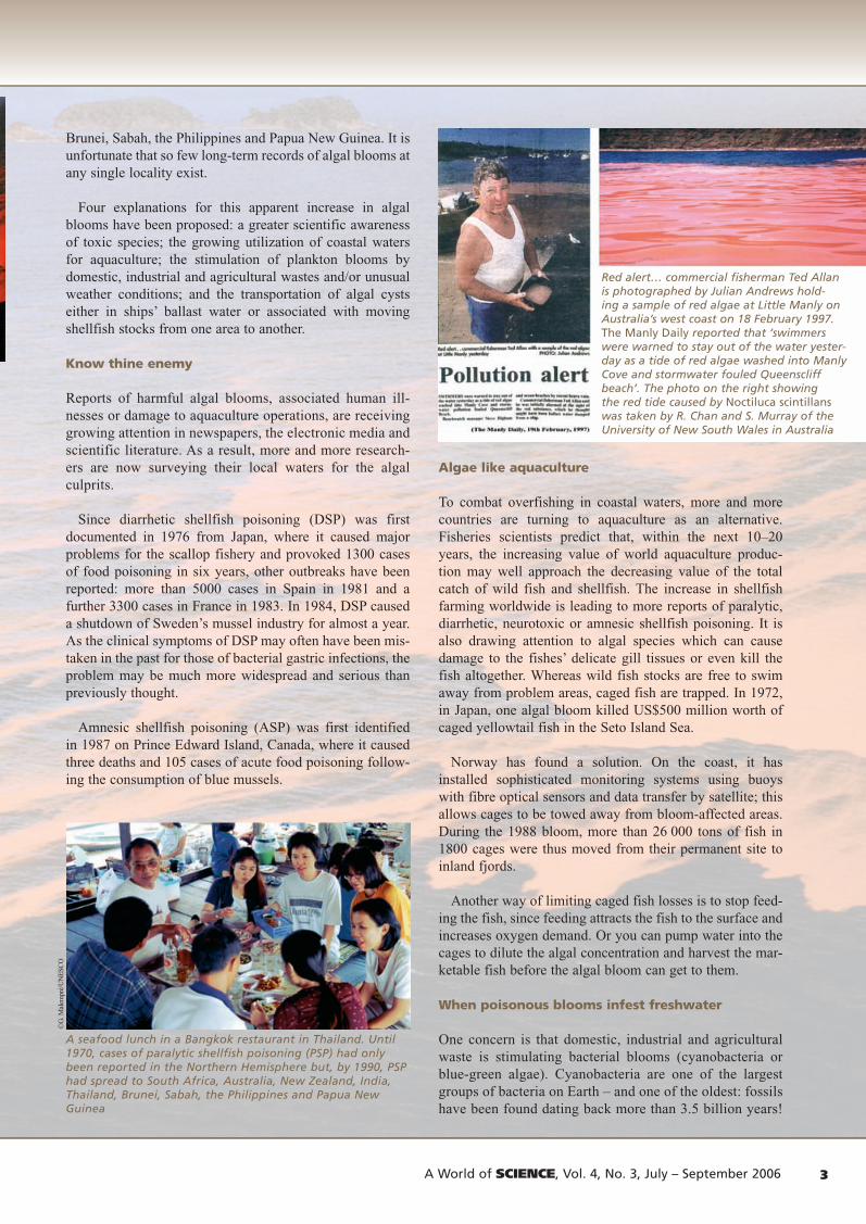
Red alert… commercial fisherman Ted Allan is photographed by Julian Andrews hold-ing a sample of red algae at Little Manly on Australia’s west coast on 18 February 1997. The Manly Daily reported that ‘swimmers were warned to stay out of the water yester-day as a tide of red algae washed into Manly Cove and stormwater fouled Queenscliff beach’. The photo on the right showing the red tide caused by Noctiluca scintillans was taken by R. Chan and S. Murray of the University of New South Wales in Australia
IN FOCUS
A World of SCIENCE, Vol. 4, No. 3, July – September 2006 3A World of SCIENCE, Vol. 4, No. 3, July – September 20062
AWOS_july06_imp_3july.indd 3 3/07/06 14:20:13

IN FOCUSIN FOCUS
A World of SCIENCE, Vol. 4, No. 3, July – September 2006 5A World of SCIENCE, Vol. 4, No. 3, July – September 20064
There are both freshwater and marine cyanobacteria and not all species are toxic. The freshwater cyanobacterium Spirulina, for example, is a valuable source of protein harvested traditionally by the Aztecs of ancient Mexico and by Africans living around Lake Chad. It is consumed widely around the world today, including as a health food. Many other species of cyanobacteria, however, are toxic to humans and animals.
Deforestation, farming and other changes in land-use may be contributing to the current proliferation of harmful fresh-water cyanobacteria. The agricultural run-off of phosphorus can stimulate blooms which form a blue-green scum on the surface of ponds, lakes and reservoirs. These blooms are capable of killing domestic and wild animals – and even people. There have been reports of human intoxication in Australia, Bangladesh, China, 12 European countries, India,
Israel, Japan, Latin America, North America, South Africa, Thailand and the former Soviet Union.
Unlike with marine algal blooms, the most common public health risk in freshwater does not arise from the accumulation of algal toxins in the digestive system of shellfish but rather from drinking water directly con-taminated with teratogens (which cause malformations in embryos) and cyanobacteria toxins which, over time, may favour the development of tumours.
Several North European countries, as well as Hong Kong and Japan, have now agreed to reduce phosphate and nitrate discharges by 50% over the next few years. This is a move in the right direction but their efforts will almost certainly be in vain if their neighbours keep polluting.
1970 2000
1990 2000
1990
Global distribution of paralytic shellfish poisoning in 1970 and 2000. A mild dose of poisoning causes numbness, headache, dizziness, vomiting and diarrhoea. The patient’s stomach is pumped and there are no lasting effects. In extreme cases, it can cause death through respiratory failure 2–24 hours after consumption of the contaminated shellfish
Global distribution of diarrhetic shellfish poisoning in 1990 and 2000. After eating contaminated shellfish, a person will experience diarrhoea, nausea, vomiting and abdominal pain within a few hours which will last about three days, irrespective of treatment. Chronic exposure can cause a tumour to form in the digestive system
AWOS_july06_imp_3july.indd 4 3/07/06 14:20:15

IN FOCUSIN FOCUS
A World of SCIENCE, Vol. 4, No. 3, July – September 2006 5A World of SCIENCE, Vol. 4, No. 3, July – September 20064
Whether the weather is to blame
There is a harmful alga by the name of Pyrodinium bahamense which is presently confined to tropical, man-grove-fringed coastal waters of the Atlantic and Indo-West Pacific. A survey of fossils going back to the warmer Eocene 50 million years ago indicates a much wider range of distri-bution in the past. For example, in the Australasian region at present, the alga is not found farther south than Papua New Guinea but, some 100 000 years ago, the alga ranged as far south as Sydney Harbour. There is genuine concern that, with an increased greenhouse effect and warming of the oceans, this species may return to Australian waters.
In the tropical Atlantic, in areas such as Bahia Fosforescente in Puerto Rico and Oyster Bay in Jamaica, the glowing red-brown blooms of Pyrodinium are a major tourist attraction. At first considered harmless, Pyrodinium blooms gained a more sinister reputation in 1972 in Papua New Guinea after red-brown water discolorations coincided with the fatal food poisoning of three children in a seaside village, diagnosed as PSP. Since then, these toxic blooms have apparently spread to Brunei and Sabah (1976), the central (1983) and northern Philippines (1987)
and Indonesia (North Mollucas). There is strong circum-stantial evidence of a coincidence between Pyrodinium blooms and inhabitual weather linked to the El Niño-Southern Oscillation1 in 1991–1994.
Pyrodinium is thus a serious public health and eco-nomic problem for these tropical countries, all of which depend heavily on seafood for protein. In the Philippines alone, Pyrodinium has now been responsible for more than 2000 human illnesses and 100 deaths resulting from the consumption of contaminated shellfish as well as sardines, anchovies and the like. Most unexpectedly, during a Pyrodinium bloom in 1987 on the Pacific coast of Guatemala, 187 people had to be hospitalized and 26 of them died. In 1989, another bloom swept northward along the Pacific coast of Central America, again causing illness and death.
2000
2000
20001990
Global distribution of amnesic shellfish poisoning (ASP) in 1990 and 2000. The symptoms are the same as for DSP in mild cases. As its name suggests, ASP can cause short-term memory loss in extreme cases, as well as hallucinations and seizures
© U
NE
SCO
/J. T
hors
ell Global distribution of ciguatera fish poisoning in 2000. The mild symptoms
are the same as for DSP and ASP but take up to 24 hours to develop. In extreme cases, balance, blood pressure and heart rate can be adversely affected. Respiratory failure can even cause death. There is no treatment available and neurological symptoms can last for months or even years
Men fishing on a freshwater lake in South Africa, one of dozens of countries where toxic microalgae have been known to kill unsuspecting cattle drinking from ponds, lakes or reservoirs and to intoxicate people
2000
AWOS_july06_imp_3july.indd 5 3/07/06 14:20:18

A World of SCIENCE, Vol. 4, No. 3, July – September 2006 7A World of SCIENCE, Vol. 4, No. 3, July – September 20066
IN FOCUS
A World of SCIENCE, Vol. 4, No. 3, July – September 2006 7A World of SCIENCE, Vol. 4, No. 3, July – September 20066
IN FOCUS
Until recently, neurotoxic shellfish poisoning (NSP) was considered to be endemic to the Gulf of Mexico and the east coast of Florida, where red tides had been reported as early as 1844. An unusual feature of NSP is the forma-tion by wave action of toxic aerosols which can lead to respiratory asthma-like symptoms in humans. In 1987, a major Florida bloom was dispersed by the Gulf Stream north-ward into North Carolina waters, where it has since persisted. Unexpectedly, in early 1993, more than 180 human shellfish poisonings were reported from New Zealand. Most likely, this bloom was triggered by the unusual weather conditions at the time, including higher than usual rainfall and lower than usual temperature, which coincided with El Niño.
Ciguatera is a tropical fishfood poisoning syndrome well-known in coral reef areas in the Caribbean, Australia and especially French Polynesia. Whereas, in a strict sense, this is a completely natural phenomenon (the English explorer Captain James Cook suffered from this illness when visit-ing New Caledonia in 1774), from being a rare disease two centuries ago, ciguatera has now reached epidemic propor-tions in French Polynesia. From 1960 to 1984, more than 24 000 patients were reported from this area, which is more than six times the average for the Pacific as a whole. Evidence is accumulating that reef disturbance by hurricanes, military and tourist developments, as well as coral bleaching (linked to global warming) are increasing the risk of ciguatera.
Algal stowaways
Ballast water is seawater which has been pumped into a ship’s hold to steady it by making it heavier and thus less likely to roll; the water is released when a ship enters port. Ballast water on cargo vessels was first suggested as a means of dispersing marine plankton some 90 years ago. However, it was only in the 1980s that the problem sparked considerable interest, after evidence was brought forward that non-indigenous toxic species had been introduced in Australian waters into sensitive aquaculture areas, with disastrous consequences for commercial shellfish farms.
There is now considerable evidence that ballast water does transport marine organisms other than microscopic algae, including species of seaweed, fish, crustaceans, star-fish and molluscs.
In February 2004, the International Maritime Organisation ratified the introduction of guidelines for ballast water handling procedures by bulk cargo vessels. These measures aim to reduce the risk of harmful introductions by encouraging a range of
Obtain an IOC certificate in identification of harmful algae
Since 1993, the UNESCO-IOC has run training courses in the identi-fication of harmful microalgae via its Science and Communication Centre on Harmful Algae at the University of Copenhagen and in cooperation with the University of Tokyo.
As of this year, the IOC is awarding certificates of proficiency in identification and enumeration of harmful marine microalgae to scientists and technicians from IOC Member States. The IOC has been inspired to redesign its courses by the example of the Natural History Museum in London, which has been offering this type of course for other species groups since 1993.
‘We know from experience that many of the more than 500 trai-nees we have had over the years have wished the courses to give accreditation’, observes Henrik Enevoldsen from the IOC’s centre in Denmark. ‘In New Zealand and elsewhere, the IOC courses have even become a reference for laboratories seeking approval to carry out regulatory monitoring of harmful microalgae’.
The new training framework offers accreditation by examination either via a training course or solely by examination for those with existing skills. In both cases, the certificate is awarded by the compe-tent IOC partner institution which organizes the examination.
The training courses consist of an Internet (e-learning) teaching pro-gramme followed by a practical workshop. The first course got under way in May with an e-learning component equivalent to approxima-tely one working day per week for six weeks. The practical part of this course is to take place at the University of Copenhagen from 10 to 18 September.
Two more courses will be run back to back in the first quarter of 2007, the first on identification and the second on enumera-tion of harmful marine microalgae. Applications will be open between 1 October and 1 January.
A close-up look at Gymnodinium, a microalga capable of causing paralytic shellfish poisoning, and of Dinophysis which causes diarrhetic shellfish poisoning
Green mussel farm in the Philippines
For details: http://ioc.unesco.org/hab/courses.htm
Courtesy of Marine Environmental Quality Control Centre in Galicia, Spain
AWOS_july06_imp_3july.indd 6 3/07/06 14:20:18

A World of SCIENCE, Vol. 4, No. 3, July – September 2006 7A World of SCIENCE, Vol. 4, No. 3, July – September 20066
IN FOCUS
A World of SCIENCE, Vol. 4, No. 3, July – September 2006 7A World of SCIENCE, Vol. 4, No. 3, July – September 20066
IN FOCUS
practices such as reballasting at sea (only feasible for vessels up to 40 000 dead weight tonnage), ballasting in deep water and disposal of ballast tank sediments away from sensitive aquaculture or marine park areas. The most effective mea-sure to prevent the spreading of microplanktonic cysts via ships’ ballast water would be to avoid ballasting during toxic blooms in ports. Other options using heat, electrical shock or chemical treatment of ballast water, either in the hold or in onshore facilities, have also been explored.
A growing menace: reality or myth?
Whether the apparent global increase in harmful algal blooms represents a real increase or not is a question we will probably not be able to answer conclusively for some time to come. There is no doubt that our growing interest in using coastal waters for aquaculture is leading to a greater awareness of toxic algal species. What researchers are faced with today are signs of a truly global epidemic in terms of the effect on public health and the economic impact of harmful algal blooms. It is time to react. In countries which pride themselves on having disease- and pollution-free aqua-culture, every effort should be made to quarantine sensitive aquaculture areas against the unintentional introduction of non-indigenous harmful algal species. Nor can any aquacul-ture industry afford not to monitor for an increasing number of harmful algal species in water and for an increasing number of algal toxins in seafood products.
Most importantly, people responsible for deciding quotas for pollutant loadings of coastal waters, or for managing agriculture and deforestation, should be made aware that one probable outcome of allowing polluting chemicals to seep into the environment will be an increase in harmful algal blooms.
Last but not least, studies looking into El Niño, green-house effects and ozone depletion etc. need to consider the possible impact of global climate change on algal bloom events. A number of new international programmes have been launched to study and manage harmful algal blooms and their linkages to environmental changes in a man-ner consistent with the global nature of the phenomena involved. Within the IOC’s Harmful Algal Bloom pro-gramme, UNESCO is doing just that.
G.M.Hallegraeff3
Adapted from the introduction to the Manual on Harmful Marine Microalgae, published by UNESCO’s Intergovern-mental Oceanographic Commission in 2003. The manual is used in UNESCO training workshops around the world.
For details: [email protected]; http://ioc.unesco.org/hab
Request a subscription to the IOC’s newsletter, Harmful Algae News: [email protected]; http://ioc.unesco.org/hab/news.htm
To order the manual: www.unesco.org/publishing
1. El Niño is caused by an imbalance in atmospheric pressure and sea temperature between the eastern and western parts of the Pacific Ocean.
2. Source: Lam and Ho (1989) Red tides in Tolo Harbour, Hong Kong. In: Red tides: Biology, Environmental Science and Toxi-cology. Elsevier. Reproduced in UNESCO (2003) Manual on Harmful Marine Microalgae.
3. Professor at the School of Plant Science at the University of Tasmania in Australia and Editor-in-Chief of the Manual on Harmful Marine Microalgae published by UNESCO in 2003
The flat-fish at this culture farm in the Republic of Korea were decimated by Cochlodinium polykrikoides
© S
an G
eun
Lee
/ Nat
iona
l Fis
herie
s R
&D
Age
ncy
1976 1978 1980 1982 1984 1986
0.5 20
16
12
8
4
0
0.4
0.3
0.2
0.1
0
© W
estp
ac/U
NE
SCO
-IO
C
Hu
man
po
pu
lati
on
(mill
ion
)
Nu
mb
er o
f re
d t
ides
Mass killing. Japanese fishermen set about the grim task of reaping a dead harvest of caged yellowtail fish (Seriola quinqueradiata) after the toxic alga Chattonella antigua decimated the ‘crop’ in the Seto Inland Sea in August 1977
Here, we can see a clear correlation between the number of red-tide outbreaks per year in Tolo Harbour (continuous line) between 1976 and 1986 and population growth in Hong Kong (bar diagram) over the same period2.
AWOS_july06_imp_3july.indd 7 3/07/06 14:20:20
A World of SCIENCE, Vol. 4, No. 3, July – September 2006 9A World of SCIENCE, Vol. 4, No. 3, July – September 20068
NEWS
A World of SCIENCE, Vol. 4, No. 3, July – September 2006 9A World of SCIENCE, Vol. 4, No. 3, July – September 20068
NEWS
A science policy for Lebanon
A five-year Science, Technology and Innovation Policy was launched in Beirut on 27 April by UNESCO Director-General Koïchiro Matsuura and the Prime Minister of Lebanon, Fouad Sanioura.
The Policy sets out to create high-quality jobs and invest-ment opportunities, at a time when ‘Lebanon runs the risk of losing out on two of its most valuable assets’: people and capital, both of which are ‘wandering abroad’. The aim is to boost economic growth by reducing the national debt burden of about US$36 billion (170% of GDP), one of the world’s highest in relation to population – Lebanon has 3.8 million inhabitants –, and to offer investment options for capital currently invested abroad by Lebanese banks.
In parallel, job creation in industry and services should absorb the large number of qualified Lebanese graduates who are either unemployed or underemployed in their home country. One-third of 18–25-year olds attend university, half of them women.
Lebanon’s role as a regional centre for quality learning, economic development, trade, tourism and health care will be developed by strengthening institutions and nurturing partnerships between the National Council for Scientific Research (CNRS), universities and centres, on the one hand, and between these and private enterprises and public agencies on the other. One recommendation concerns the establishment of a Knowledge Gateway Industry Lebanon, which would combine a database and Technology Promotion Units at each of the major universities and research centres to help small and medium-sized enterprises in particular to articulate their needs and benefit from these institutions’ expertise and resources. Sectoral centres of excellence (real or virtual) will also be set up for manufacturing sectors, such as clothing, shoes and furniture.
Technology will be used in more efficient and creative ways to add value to production and services which, in turn, should reduce Lebanon’s huge trade imbalance. Targets include reducing industrial operating costs and improving productivity, harnessing ICTS for development (just 14% of the population had access to Internet in 2003) and establishing new industries. Key existing industries include banking, food processing, jewellery, cement, wood and furniture products, textiles, mineral and chemical products, and oil refining.
Agriculture represents about 12% of GDP, employs 9% of the workforce and provides a large share of raw pro-ducts for industry. By 2007, the country expects to have eliminated methyl bromide, a fumigant used to control a wide range of pests that is dangerous for both human and animal health. This should clear the way to greater exports of foodstuffs.
Iron ore, limestone and salt figure among Lebanon’s natural resources. The country is also in the enviable position of having a water surplus in a region deficient in water. Environmental
concerns include deforestation, soil erosion and desertifica-tion, as well as coastal water pollution from raw sewage and oil spills. The Policy seeks to improve management of energy, water, coastal regions and other natural resources by adopting an integrated, sustainable approach. Public and Professional Information Units will be set up in new or existing centres of excellence to report on research on coastal zones, water, new agricultural opportunities and food quality.
Health care is to become a pillar of the Lebanese econ-omy. In creating an environment conducive to a flourish-ing biomedical industry and services sector, the aim is to ‘resume Lebanon’s position as a regional leader in the field of medicine and health care through improving higher medical and science education, and through improving the quality and cost-effectiveness of medical and health care’.
The Policy sets out a strategy for broadening Lebanon’s participation in regional and wider international networks. It recommends, for example, increasing the representation of the outside world on steering committees and advisory boards of universities and institutes. Closer ties are also to be forged with the country’s sizeable diaspora.
UNESCO set in motion the formulation of a science policy for Lebanon three years ago. The report launched in April reflects the work of four task forces led by UNESCO consul-tant Peter Tindemans and involving 30 prominent Lebanese scientists as well as international experts. The Policy is published by the CNRS, a key partner in the endeavour. Substantial input has also come from the UN Economic and Social Commission for Western Asia (ESCWA) and the Arab League Educational, Cultural and Scientific Organization.
Lebanon is lacking in statistical data on the state of science, innovation and technology, so the UNESCO Institute for Statistics and ESCWA will be helping the CNRS to establish an observatory, the first task of which will be to identify a set of indicators for monitoring the country’s performance.
Lebanon was ravaged by war from 1975 to 1990. By 2002, per capita income had climbed to US$ 4,552 (purchase power parity dollars) from $3,178 in 1995. Life expectancy stands at 72 years and the population is growing at an annual rate of 1.2%, well below the average for the Arab world of 2.3%.
Read the report: www.cnrs.edu.lb/stip/stip.htm
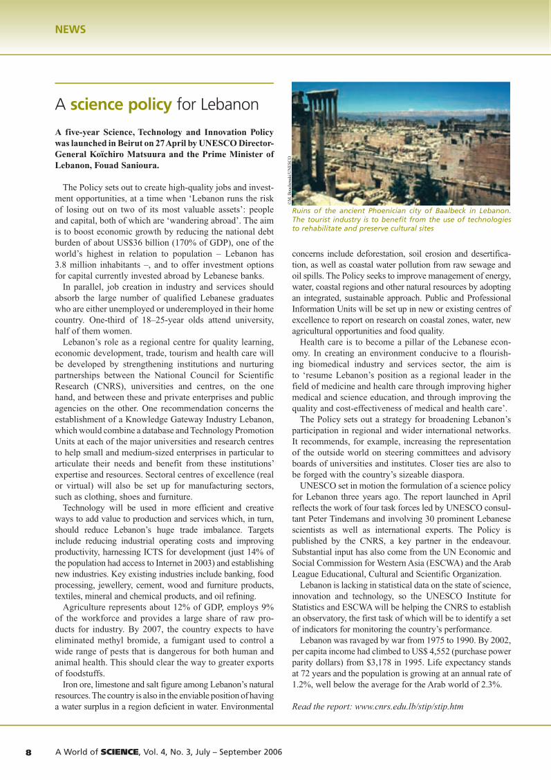
Ruins of the ancient Phoenician city of Baalbeck in Lebanon. The tourist industry is to benefit from the use of technologies to rehabilitate and preserve cultural sites
©M
. Bou
chen
aki/U
NE
SCO
AWOS_july06_imp_3july.indd 8 3/07/06 14:20:20

A World of SCIENCE, Vol. 4, No. 3, July – September 2006 9A World of SCIENCE, Vol. 4, No. 3, July – September 20068
NEWS
A World of SCIENCE, Vol. 4, No. 3, July – September 2006 9A World of SCIENCE, Vol. 4, No. 3, July – September 20068
NEWS
Kit helps kids discover drylands
A kit designed to stimulate the natural creativity of children while teaching them about their environment has received US$334,000 in funding from the Flemish Government in Belgium. This funding will enable the kits to be distributed to thousands of primary and secondary schools in dryland countries.
The Teaching Resource Kit for Dryland Countries is being developed by UNESCO's Man and the Biosphere Programme. Distribution of the kit, which will initally be produced in Arabic, English, French, and Spanish, is expected to begin in late 2006. Countries initially targeted include those participating in the project for the Sustainable Management of Marginal Drylands (SUMAMAD), namely China, Egypt, Iran, Jordan, Syria, Tunisia, Pakistan and Uzbekistan. Other dryland countries will be receiving the kits through UNESCO’s network of Associated Schools.
The kit comes with a teacher's manual proposing activities that schools in drylands can implement at little or no cost.
The presentation sample of the manual proposes three activities within a lesson on Discovering the Ecosystem and its Biodiversity:◗ in Collecting Treasures, the teacher encourages pupils
to take a fresh look at their environment by collecting as many natural objects as possible: fragments from rocky strate, unusual stones, soil and mud samples, bush and shrub branches, fruit and grains of all kinds, fungi and lichens, fossils, etc. The children then examine the rela-tion between each object and its habitat to help them grasp the concept of ecosystem.
◗ in Land, Rock and Erosion, the teacher helps pupils to understand the local landscape by exploring its geo-logical structure and features. Through drawing, the children come to grasp the 'plastic' effect of winds on the landscape, such as observing the sunny and shady sides
of a dune blown by the wind in order to understand its erosive action. With their sketch pads, the children may capture the crumbling of the rock into worn rocks or depict furrows made in fossilized sandstone by the wind.
◗ An Inventory of Useful Plants helps children question the local population's use of the environment from the perspective of sustainable development. The ecosystem is likened to a nourishing garden (edible plants), a heal-ing garden (medicinal plants and oils) and a protecting garden (the use of plants in house-building and clothes manufacturing).The Teaching Resource Kit for Dryland Countries is
a new product of the Desertification Kit launched by UNESCO and UNCCD in 2003 (see A World of Science, January 2005). The first kit was ultimately distributed in nine languages: Arabic, English, Chinese, French, German, Hindi, Mongolian, Spanish and Russian.
These materials are part of UNESCO’s contribution to the United Nations Decade of Education for Sustainable Development, which runs until 2014.
For details: [email protected]; h.gille @unesco.org
Humans bigger danger for coral reefs than tsunami
A report launched in Paris on 14 March concludes that human stresses prior to 26 December 2004 have caused more damage to coral reefs and mangroves in the Indian Ocean than the earthquake and tsunami which swept across the region 18 months ago.
Entitled Status of Coral Reefs in Tsunami-Affected Countries: 2005, the report is the joint effort of numerous bodies, including the Australian and US governments, Australian Institute of Marine Science, UNESCO-IOC, UNEP, World Conservation Union (IUCN) and Reefbase (Malaysia). Launched at the Australian Embassy in Paris, the report assesses damage caused by the tsunami to coral reefs and other coastal ecosystems.
The report concludes that most of the coral reefs in the region escaped serious damage and will recover naturally from the tsunami within 5–10 years, providing that coun-tries minimize overfishing, destructive fishing, coral min-ing and both sediment and nutrient pollution.
Most of the damage to coral reefs resulted from sediment and coral rubble being thrown about by the waves and from smothering by debris washed off the land. The tsunami compounded the damage caused by El Niño in 1998 by killing some newly settled corals and by hurling around the coral rubble produced after about 16% of the world’s coral reefs were killed by coral bleaching. The report warns that ‘other climate change factors, such as an increase in ocean acidity and water temperature, pose greater threats to reefs in the future than natural disturbances’.
©Olivier Brestin
In the activity on Following in the Footsteps of Wild Animals, the teacher and a ‘tracker’ help the pupils approach different species of animal by identifying the animals’ footprints in their natural environment
AWOS_july06_imp_3july.indd 9 3/07/06 14:20:21

A World of SCIENCE, Vol. 4, No. 3, July – September 2006 11A World of SCIENCE, Vol. 4, No. 3, July – September 200610
NEWS
A World of SCIENCE, Vol. 4, No. 3, July – September 2006 11A World of SCIENCE, Vol. 4, No. 3, July – September 200610
NEWS
The report observes that ‘the tsunami washed directly over coral reefs’ in most countries in the Indian Ocean, ‘which may have provided some limited protection to the land behind’, although not when the waves were particu-larly large. Conversely, it notes that mangrove forests and other coastal vegetation were particularly effective in mini-mizing the damaging effects of the waves on land and in trapping large debris.
Coral reef damage was greatest in the four countries closest to the origin of the tsunami wave:
In Indonesia, a government assessment revealed 30% damage to 97 250 ha of coral reef at a net loss of US$332 million, although there was little baseline information on the status of coral reefs in northern Sumatra prior to the tsunami. ‘Reefs near the epicentre on Simeulue Island were uplifted out of the water and killed, whereas deeper reefs nearby were apparently unaffected’ (see photo). On other reefs, damage arose from debris and sediments washing off the land. Approximately 600 ha of seagrasses were destroyed, along with up to 85 000 ha of mangroves.
In Thailand, the majority (61%) of corals were either spared or suffered little harm, although approximately 13% were severely damaged. Reef damage was caused by the waves dislodging, breaking and moving corals, and by smothering and abrasion by sediments and debris washed off by land. There remain large areas of healthy corals. Only 5% of seagrass beds were affected and there was little damage to mangroves.
Off the coast of India, the secondary earthquakes uplifted entire reefs out of the ocean in the northern Andaman Islands and thrust other reefs several metres downwards in the southern Andaman and Nicobar Islands. Mainland coral reefs were largely unaffected. Many beaches have been seriously eroded, which could affect turtle nesting.
Sri Lanka was struck by tsunami waves converging from both Sumatra and the Andaman and Nicobar Islands.
The waves struck the northeast coast near Trincomalee before wrapping themselves around the island to impact on the southwest coast. The damage to reefs in these areas was patchy and frequently caused by the movement of rubble from the corals killed by bleaching in 1998. In other areas, live branching and massive colonies (up to 50 cm) were toppled, while others were smothered by marine sediments. Severe but patchy beach erosion on many coasts was exacerbated by extensive illegal coral mining prior to the tsunami.
The report encourages governments and international agencies to continue clearing debris from beaches, coral reefs and mangrove forests to prevent further damage and facili-tate more rapid recovery of the ecosystems; it urges them to exercise caution about introducing unproven, expensive technology to repair damaged coral reefs, such as ‘electric technology’ or the placement of concrete blocks, as these technologies may prove to be destructive in the long term.
To consult the report: www.aims.gov.au
UNESCO Chair in Earth sciences for Nigeria
A UNESCO Chair launched on 22 May at the University of Ibadan sets out to reverse the Nigerian paradox of poverty in the midst of plenty by improving the way in which the country’s georesources are managed.
Current extraction and management practices may have gen-erated foreign exchange earnings from the sale of Nigeria’s rich reserves of oil, natural gas and minerals but they have clearly failed to bring Nigerians a sustainable livelihood.
This paradox is partly due to the fact that the development of georesources has traditionally been confined to the engi-neering disciplines of petroleum, geosciences, mining and hydrology. By combining these disciplines with econom-ics and environmental studies, the aim of the UNESCO Chair in Earth Sciences and Georesources Engineering Management is to train engineers, managers and policy-makers to balance the need for extracting georesources for national growth with a sensitive approach to the social and environmental needs of local communities.
The Chair will develop a new academic graduate degree programme in Georesources Engineering Management and an undergraduate minor in Society, Technology and the Environment of Africa. It will foster multidisciplinary research and design an interdisciplinary course on geologi-cal resource exploitation and environmentally sound deve-lopment of those regions in which mineral deposits or oil fields are found. As the Chair will be extremely beneficial for the local mining and oil companies, it is these compa-nies which will shoulder the financial burden of the Chair.
The Chair proposes an innovative Visiting Professor scheme. Scientists, engineers, economists and social scien-tists from Penn State University in the USA, the University
The underwater earthquake on 26 December 2004 began 30 km deep into the Earth’s crust and caused permanent movement of the Earth’s surface. Near the epicentre, the northwestern flank of Simeulue Island was raised 1.5 m, exposing coral reefs like the one pictured here. Within about 10 minutes, the earthquake had ruptured a 1300 km segment of the Sunda Sub-plate stretching from Sumatra northward to
the Andaman Islands, where tilting of the Burma Microplate caused islands to uplift out of the water by about 1 m in the western regions and to subside by about as much in the eastern regions, flooding buildings and fields permanently. Land was also displaced horizontally: by up to 6 m in parts of the Andaman and Nicobar Islands; the island of Phuket in Thailand moved 28 cm to the southwest and even Singapore moved 2 cm westward
© Craig Shuman, Reef Check Foundation, USA
AWOS_july06_imp_3july.indd 10 3/07/06 14:20:21

A World of SCIENCE, Vol. 4, No. 3, July – September 2006 11A World of SCIENCE, Vol. 4, No. 3, July – September 200610
NEWS
A World of SCIENCE, Vol. 4, No. 3, July – September 2006 11A World of SCIENCE, Vol. 4, No. 3, July – September 200610
NEWS
of Cape Town in South Africa and the University of Ibadan are to form a network for the transfer of knowledge and capacity, through collaboration in the form of sabbaticals, exchanges and internships.
The Chairholder is to be designated shortly by the University of Ibadan.
For details: [email protected]
Federation of African Societies of Chemistry founded
The Federation of African Societies of Chemistry was founded on 23 February in Addis Ababa (Ethiopia). The founding members are the Chemical Societies of Egypt, Ethiopia, Nigeria, South Africa, Sudan and Tunisia, as well as the African Association of Pure and Applied Chemistry based in Tanzania.
The Federation will ‘create a network of African chemists to encourage cooperation and help disseminate research results’, explains newly elected President Temechegn Engida, who is Vice-President of the Chemical Society of Ethiopia and a National Programme Officer at UNESCO’s International Institute for Capacity-Building in Africa (IICB), situated in Addis Ababa.
The Federation plans to embrace as many African chemical societies as possible in the coming years and to establish working groups in food chemistry, environmental chemistry, analytical chemistry, natural products and medicinal chemistry, among other areas. It will also strive to improve chemistry teaching and to raise public understanding of chemistry and the role it plays in eco-nomic development.
Dr Engida himself is a specialist in chemistry education. He is joined on the Executive of the Federation by Vice-President Prof. M.M. Khater from Egypt and Treasurer Dr Yonas Chebude from Ethiopia.
One role of the Executive will be to attract donor funding for projects conceived within the Federation’s strategy for 2006–2010, which has three thrusts:◗ To enhance the position of member chemical societies
as the source of information of the highest quality, the Federation plans to publish research by African chemists in print and electronic form; it also plans to produce high-quality, cost-effective materials for both theoretical and experimental chemistry;
◗ To help member chemical societies develop a commu-nity of highly skilled practitioners, the Federation plans to organize short-term training courses and competitive award programmes. It also plans to foster networking
and reform of chemistry education. In this regard, the Federation is exploring the possibility of distribut-ing DIDAC teaching materials to schools via member chemical societies. These chemistry teaching materials have been developed jointly by UNESCO, the photo-graphic giant AGFA, the International Union of Pure and Applied Chemistry (IUPAC) and the Royal Flemish Chemical Society in Belgium. Avenues are also being explored for participating in the Global Microscience Programme run by UNESCO and IUPAC in tandem with the RADMASTE Centre in South Africa. This project has developed low-cost, safe, small-scale kits for con-ducting experiments in chemistry and other disciplines at school, and has introduced the methodology through-out the world. In Africa, there are UNESCO-associated microscience centres in Cap Verde, Cameroon, Comores, Gabon, Kenya, Mauritius, Senegal and South Africa (see A World of Science, January 2003).
◗ To support the efforts of member chemical societies to ‘spread the word’ about the value of chemistry for society and the need both to integrate science in national policy development and to invest in chemistry, the Federation plans to publish the works of chemists who have made valuable contributions to society. It will also
be providing products and services to students, teachers and policy-makers.
Foreign Minister Seyoum Mesfin told the inaugural meeting on 23 February that he was deeply encouraged by the commitment African chemists had shown in establishing the Federation. He assured participants that Ethiopia fully recognized the role played by pro-fessional associations and their efforts to utilize their knowledge and skills to develop the national economy.
For Dr Joseph Ngu, Acting Director of IICBA, the new Federation will facilitate UNESCO’s efforts to strengthen science, education and scientific research on the continent. ‘Even though many chemists are graduating from African universities and joining the workforce each year’, he told the assembly, ‘African countries have not benefited enough from the inherent potential of chemistry’.
The founding ceremony preceded the 22nd Annual Congress of the Chemical Society of Ethiopia on 24 and 25 February, the theme of which was Chemistry in Africa in the 21st
Century. UNESCO, the International Science Programme and the Royal Society of Chemistry in the UK were among a host of partners which funded the participation of African chemists from beyond Ethiopia over the three days.
The Executive is in the process of forging ties with chemi-cal societies outside Africa. It is approaching the European Association of Chemical and Molecular Sciences and the Chemical Society of Germany, among others.
For details: [email protected]; [email protected]; www.aau.edu.et/; www.unesco-iicba.org
Chemistry class in Kenya
© U
NE
SCO
AWOS_july06_imp_3july.indd 11 3/07/06 14:20:22

A World of SCIENCE, Vol. 4, No. 3, July – September 2006 13A World of SCIENCE, Vol. 4, No. 3, July – September 200612
NEWS
A World of SCIENCE, Vol. 4, No. 3, July – September 2006 13A World of SCIENCE, Vol. 4, No. 3, July – September 200612
NEWS
UNESCO condemns terror campaign against Iraqi academics
On 5 April, the Director-General of UNESCO condemned the campaign of violence waged against Iraqi academics and intellectuals and called for ‘international solidarity and mobilization in favour of education and educators in the country’.
‘Iraq has a long tradition in learning and academic excel-lence in the Middle East’ the Director-General declared. ‘By targeting those who hold the keys to Iraq’s reconstruc-tion and development, the perpetrators of this violence are jeopardizing the future of Iraq and of democracy. We can-not stand by and watch the custodians of Iraq’s culture and learning be threatened, abducted or murdered’.
Mr Matsuura spoke out after the Geneva-based Study and Research Center for the Arab and Mediterranean World announced that four Iraqi academics, including one physician, had been killed the previous week. The Center says that close to 200 academics have been killed in Iraq since 2003 and that thousands more have been driven into exile.
UNESCO is currently helping the Iraqi Ministry of Higher Education to reconstruct higher education in the country. On 14 April, Mr Matsuura met with Muhyi Alkateeb, Iraq’s Ambassador and Permanent Delegate to UNESCO, and members of the International Committee for the Protection of Iraqi Academics. This Committee was created in February this year, under the Geneva-based center.
Pacific tsunami warning system put to the test
Thirty countries participated in the first-ever region-wide drill for the Pacific Tsunami Warning System on 16 and 17 May. Code-named Exercise Pacific Wave ’06, the drill had been planned long before a 7.9 magnitude earthquake shook the small Pacific Island State of Tonga on 4 May local time, putting the system to a real test.
The Pacific Tsunami Warning and Mitigation Centre in Hawaii issued its first information bulletin just 15 minutes after the earthquake, which occurred 160 km northeast of Nuku’alofa in Tonga and was felt as far away as Auckland in New Zealand, some 2145 km south of the epicentre. There were no reported casualties and the tsunami alert turned out to be short-lived, as the major submarine earth-quake generated a wave of only about 20 cm.
‘A few years ago, it would have taken almost an hour’ [to issue a first bulletin]’, commented Patricio Bernal, Executive Secretary of UNESCO’s IOC, shortly after the Tongan earthquake. ‘This rapidity is largely due to the real-time availability of seismic and sea-level data from stations in the Pacific Tsunami Warning System’s Member States’.
The Tongan earthquake also revealed weaknesses in the System, such as ‘the need to improve the information bulletins’ issued by the Pacific Centre in Hawaii. ‘These internal bulletins are now available to people outside the system and must be able to be understood by all – whether scientist, journalist or layperson’, observed Bernal. ‘There is also clearly a need for better public education on the way the system operates. [On 4 May,] there was no official warning issued by any national authority, the only ones mandated to do so’.
Twelve days later, the IOC-sponsored drill went ahead as planned. According to the scenario, a 9.2 magni-tude earthquake off the coast of Chile at 19:04 hours (Greenwich Mean Time) sent an imaginary tsunami racing across the eastern Pacific. A second mock alert from the Pacific Centre in Hawaii, this time indicating an earth-quake north of the Philippines, tested responses in the western Pacific.
‘Our main concern’, commented Bernal the day after the drill, ‘was to test the international and national com-munication networks to make sure that the information was received quickly by the right people in all participat-ing countries. Initial reports show that this has worked very well, despite the challenge posed by a series of real earthquakes that actually happened in the region hours before and even during the test’. In Malaysia for example,
The Pacific Ring of Fire is formed along plate boundaries. It concentrates 90% of the world’s earthquakes and much of the world’s volcanic activ-ity; hence why 59% of all tsunamis occur in the Pacific Ocean. Indonesia has more active volcanoes (130) than any other country on Earth. The most active of these is Mount Merapi (or Mountain of Fire) in Central Java, which began erupting in May. Mount Merapi lies just 70 km from the epicentre of the 6.3 earthquake which struck the densely populated island on 27 May, killing more than 6200 people and leaving hundreds of thousands homeless
Source: U.S. Geological Survey
AWOS_july06_imp_3july.indd 12 3/07/06 14:20:22

A World of SCIENCE, Vol. 4, No. 3, July – September 2006 13A World of SCIENCE, Vol. 4, No. 3, July – September 200612
NEWS
A World of SCIENCE, Vol. 4, No. 3, July – September 2006 13A World of SCIENCE, Vol. 4, No. 3, July – September 200612
NEWS
Meteorological Department Deputy Director-General Leong Chow Peng reported that ‘the exercise showed our commu-nication channels with the emergency response units and meteorological agencies from around the region were well linked’ (New Straits Times, 18 May).
In a second phase, government officials disseminated the message within their country to the local emergency management authorities of at least one coastal community. Although communication drills are frequent in the system, this was the first time a drill had ‘gone that extra mile’ by checking on the capability of national authorities to reach those at risk. ‘The early results show up some of the areas that need improving in this network’, noted Bernal, such as ‘the ability to disseminate public warnings effectively, especially very late at night or during the early hours of the morning’. The Emergency Management Group headquar-ters in Auckland, for instance, was told to expect a wave originating from Chile to hit its shores at 1.30 am. The Group had the task of urging people to evacuate low-lying areas and climb to at least 35 m above sea level. After the drill, Auckland Civil Defence chiefs said they were confi-dent they would be able to give the public adequate warning of an approaching tsunami.
The drill highlighted another concern. ‘In the scenario applied yesterday’, Bernal explained, ‘the Chilean authori-ties would have had to respond in a few minutes with incomplete information. Japan, on the other hand, would have had 22 hours to assess the event and adopt the proper emergency measures.’
‘If a tsunami were generated close to New Zealand shores, it would leave little time to issue a warning’, said Barry Low, Manager of Emergency Management for Tauranga and the Western Bay region of New Zealand, after the drill. ‘Families, schools, businesses need to sit down as a group and discuss their safety, come up with a plan’ (Bay of Plenty Times, 18 May). Like many Pacific countries, New Zealand lies in the Ring of Fire (see map).
Several countries, including Malaysia, the Philippines, Samoa and Thailand, used the drill to conduct evacuation exercises in selected coastal communities and schools.
For details: http://ioc3.unesco.org/itic/
African World Heritage Fund launched
A fund to help countries in Africa improve the preser-vation of their natural and cultural heritage and boost the number of African sites on UNESCO’s World Heritage List was launched in South Africa on 5 May.
Sub-Saharan Africa is severely underrepresented on the World Heritage List, despite the continent’s great cultural and natural diversity and the fact that 42 coun-tries have ratified the World Heritage Convention.
Only 65 of the world’s 812 World Heritage sites are to be found in Sub-Saharan Africa: 32 natural sites, 31 cultural sites and 2 mixed sites.
South Africa has donated 20 million rand (circa US$3.5 million) to help launch the Fund. A campaign to achieve the initial capital endowment of US$10 million is under way across the continent and among the broader international community. The private sector is expected to become a key partner in the future.
Under the Fund, grants will be awarded to help African States Parties to the World Heritage Convention prepare national inventories of their heritage sites and nominate sites for inscription on the World Heritage List. Assistance will be extended to the training of personnel to carry out these tasks.
Heritage properties in general, including those already inscribed on the World Heritage List, will be eligible for funding, as will properties on the List of World Heritage in Danger requiring assistance for rehabilitation; 14 African properties feature among the 34 sites on the List of World Heritage in Danger.
Created as a Trust under South African law, the Fund will be managed and housed for at least two years by the Development Bank of Southern Africa, which has thus far handled the feasibility study and the registration of the Fund free of charge. The Fund will be run by a Board of Trustees.UNESCO and the African Union will each have an observer on the Board. All trustees will have proven expertise in heritage preservation and financial management of legal affairs. Their unpaid appointment will be for a three-year term of office, renewable once.
It is expected that the first grants from the Fund will be made in 2007. Grant applications will be reviewed annually.
For details: http://whc.unesco.org/
Restoring the roof of Djingarey Ber Mosque in Timbuktu, a World Heritage site since 1988. The men are laying branches on top of palm tree beams before adding a layer of mud. This is one of three mosques restored in 2003 within a project carried out by the Timbuktu Cultural Mission and the population of Timbuktu with the support of CRATerre-EAG and funding from the UNESCO World Heritage Centre. Since January, the Malian authorities have been developing a management and conservation plan for Timbuktu, which they intend to submit to the World Heritage Committee later this year. In March, the municipality set up a management committee composed of the imams of the three mosques, representatives of all local areas, tour guides and municipal and administrative authorities
© U
NES
CO/ J
. Sop
ova
The Pacific Ring of Fire is formed along plate boundaries. It concentrates 90% of the world’s earthquakes and much of the world’s volcanic activ-ity; hence why 59% of all tsunamis occur in the Pacific Ocean. Indonesia has more active volcanoes (130) than any other country on Earth. The most active of these is Mount Merapi (or Mountain of Fire) in Central Java, which began erupting in May. Mount Merapi lies just 70 km from the epicentre of the 6.3 earthquake which struck the densely populated island on 27 May, killing more than 6200 people and leaving hundreds of thousands homeless
AWOS_july06_imp_3july.indd 13 3/07/06 14:20:23

A World of SCIENCE, Vol. 4, No. 3, July – September 2006 15A World of SCIENCE, Vol. 4, No. 3, July – September 200614 A World of SCIENCE, Vol. 4, No. 3, July – September 2006 15A World of SCIENCE, Vol. 4, No. 3, July – September 200614
What makes the UNU unique within the United Nations system?
For one thing, both the Rector and the 24 Council members are appointed jointly by the Secretary-General of the United Nations and the Director-General of UNESCO. With our focused mission, it is important to have high-level academics with diversified experience on the Council. Quite a number of members are, or have been, ministers or high-ranking officials in ministries, or have come from a company, an NGO, a foundation or the multilateral system.
Each Council member serves in a personal capacity and thus does not represent a Member State. I think that is a crucial point. The Council is not an intergovernmental
body. This gives the UNU autonomy, independence and academic freedom. We work with institu-tions in countries, not with the countries themselves. This is another feature that makes the UNU unique within the United Nations system.
How do you respect geographical balance?
The seats of the Council members are distrib-
uted across seven regions: Africa and Asia–Pacific, Arab States, Eastern Europe, Latin America,
North America and Western Europe. For each vacant post, the Council proposes three names from each region to the Secretary-General of the United Nations and the Director-General of UNESCO. The term of appointment is six years, non-renewable.
One seat on the Council is reserved for a national of the host country, Japan, as well as one seat for each of the per-manent members of the United Nations Security Council, China, France, Russia, UK and USA. There has been some discussion in the past as to whether this system should be maintained. There are also four ex-officio members: the Secretary-General of the United Nations, Director-General of UNESCO, Executive Director of the United Nations Institute for Training and Research, and the Rector of the UNU.
Where does your advantage lie in being a ‘university’?
We are a university in order to guarantee the objectivity and integrity of our work and publications; we are also part and parcel of the United Nations, as our programme is directly linked to the issues on the table of the United Nations. This is why we are not involved in biology, sociology and the like.
But doesn’t your programme include biotechnology and biopharmacy?
Yes, it does but that is because these areas have something to do with agriculture and biodiversity. We focus on science and technology for society. Our programme is policy-oriented.
This policy angle is reflected, for example, in the report published by the UNU last year on Bioprospecting of Genetic Resources in the Deep Seabed, co-authored by
INTERVIEW
Hans van Ginkel
A think-tank within the United NationsThe United Nations University (UNU) is one of the lesser-known United Nations agencies. How many people know, for instance, that it was established by UNESCO and the United Nations in 1973? Or that it proposes specialized postgraduate courses from its headquarters in Tokyo? The UNU’s international community of scholars seeks to bridge the gap between the United Nations and academia through research, policy studies and capacity-building in the areas of peace and security, governance, human development, science, technology and society, and environment. Ever since its inception, the UNU has maintained close ties to both ‘parent organizations’. Collaboration with UNESCO has grown considerably since a short-term staff exchange programme was put in place in 2001.
Hans van Ginkel is former Rector of Utrecht University in the Netherlands and has been Rector of the UNU since 1997. He is also Under-Secretary-General of the United Nations. Here, he explains why the UNU is unique within the United Nations system and how collaboration with UNESCO is growing.
Hans van Ginkel
AWOS_july06_imp_3july.indd 14 3/07/06 14:20:24

A World of SCIENCE, Vol. 4, No. 3, July – September 2006 15A World of SCIENCE, Vol. 4, No. 3, July – September 200614 A World of SCIENCE, Vol. 4, No. 3, July – September 2006 15A World of SCIENCE, Vol. 4, No. 3, July – September 200614
Salvatore Arico from UNESCO and Charlotte Salpin4. The policy side concerns global covenants and agreements on ownership, access and benefit-sharing. At the end of the day, the deep-sea issue is a governance issue, just as Antarctica was in the 1990s. The question is ‘Who has con-trol?’ Who ‘owns’ these resources? Who is responsible? The frontier of human exploration has simply shifted from Antarctica5 to the deep sea and outer space.
What feedback has there been on this report on bioprospecting of the deep seabed?
Quite a lot, I think, but feedback seems to be coming from people with a technical background at this stage, people who know the legal and economic consequences of the issue. They are very positive about the report and praise its timeli-ness. For most governments, the problem is still relatively far beyond their present horizons. I am sure this will soon change. This reaction is characteristic of much of the work of the UNU and illustrates that the UNU is as proactive as it wants to be. Once an issue has become a problem and govern-ments have taken a position on it, it becomes very difficult for them to listen to a scientist who then comes along and tells them to look at the situation differently. Basically, you should be there with your policy advice before the govern-ments, politicians and diplomats speak out in public.
One of the examples I like to give goes back to 1975. One of the UNU’s first three programmes was designed to focus on human and social development, at a time when many still looked at progress in terms of economic growth. The UNU’s World Institute on Development Economics Research was established in 1985 to focus on this topic. The UNDP’s Human Development Report was launched in 1990.
Did you know that UNESCO published A New Concept of Development in 1983?Concept of Development in 1983?Concept of Development 6 This book followed up a UNESCO meeting of experts on the theme of Research on the Idea of Inte-grated Development, in Ecuador in 1979.
Yes, I did know; our programme started in 1975. Let me give you another example. I pride myself on having appeared on the front page of the UK Financial Times in 1999 to alert people to the prospects of severe water shor-tages in the 21st century, at a time when they were not yet focusing on the water issue7. This was in relation to the celebration of World Water Day that year.
How much cooperation is there between the UNU and UNESCO in freshwater?
A lot. The UNU contributed to the first and second World Water Development Reports published in 2003 and 2006 for example. One of the UNU’s two water-related research and training centres, the International Network on Water,
Environment and Health in Canada, has been contributing since the outset to this report. I think this is one of the best examples of collaboration between UNESCO and the UNU.
In my speech at the launch of the second report at the World Water Forum in Mexico last March, I congratulated UNESCO on its stewardship, on behalf of the entire United Nations system, of the World Water Assessment Programme which coordinates preparation of the report.
You spoke of two water-related UNU centres?
The second is the Institute for Environment and Human Security, set up in 2003 in Germany and headed, I might add, by Janos Bogardi, a former Programme Specialist in UNESCO’s Division of Water Sciences.
After freshwater, what would be the key areas in which UNESCO and the UNU collaborate?
Traditionally, the UNU has had ties to higher education, which is why we worked closely with UNESCO on the preparation of the World Conference on Higher Education in 1998. Nonetheless, since we are focusing more on policy-oriented research and on our role as ‘think-tank’, it strikes me as being equally important for the UNU to have a strong link to the natural and social sciences. The short-term staff exchange programme with UNESCO since 2001 helps to concretize this cooperation.
Let me give you a couple of examples of current collabo-ration. We are presently producing the second edition of the World Atlas of Mangroves with Miguel Clüsener-Godt from UNESCO, who has participated in the staff exchange programme, and other partners. UNESCO and the UNU also organized the First Regional Conference on Biosphere Reserves in the Amazon last April, in Georgetown, Guyana, within a programme promoting South–South Cooperation for the Sustainable Development of the Humid Tropics. This programme dates back to 1992 and also involves the Academy of Sciences for the Developing World (TWAS), of which I am associate fellow.
Has the staff exchange programme helped to strengthen collaboration?
It definitely has. I think the most successful exchange involved Thomas Schaaf, who came to Tokyo from UNESCO in 2001 while Adeel Zafar travelled from Tokyo to UNESCO in Paris. With Thomas, we looked at areas south of the Sahara and into the western part of China and Mongolia to see how we could strengthen cooperation between different centres of excellence in research and teaching in the area of desertifica-tion. This led to the project for the Sustainable Management of Marginal Drylands (SUMAMAD), funded by the Flemish Government in Belgium to the tune of US$800,000. It brings together not only UNESCO and the UNU but also
AWOS_july06_imp_3july.indd 15 3/07/06 14:20:24
A World of SCIENCE, Vol. 4, No. 3, July – September 2006 17A World of SCIENCE, Vol. 4, No. 3, July – September 200616 A World of SCIENCE, Vol. 4, No. 3, July – September 2006 17A World of SCIENCE, Vol. 4, No. 3, July – September 200616
the International Centre for Agricultural Research in Dry Areas (ICARDA) and the United Nations Convention to Combat Desertification. The project involves China, Egypt, Iran, Jordan, Syria, Tunisia, Pakistan and Uzbekistan.
Why circumscribe the project to just eight countries?
Simply because we had to lower our sights. The original idea was to include all countries from the Sahelian zone to Mongolia. For financial reasons, we could only go with those countries in which there were the most active research centres, such as the Institut des régions arides in Tunisia and the Chinese Academy of Sciences’ Institute for Cold and Arid Regions in Lanzhou in western China. All eight centres involved in the project have proven to be most effective and in a way have selected themselves. At the end of the day, given the limited amount of money available for developing both a joint Master’s programme and a research programme, we decided to go with these eight centres for the time being. The aim of SUMAMAD is to develop coop-eration between these centres but SUMAMAD is one step in a bigger strategy to develop a network of universities and research centres in land management in marginal drylands in the countries of Central and West Asia and of North Africa, what we call the CWANA+ network.
We launched CWANA+ at the ICARDA conference in Beijing on drylands management last February, which was co-sponsored by UNESCO, UNU and others. The next step after SUMAMAD ends in 2008 will be to extend the project to institutions in Mongolia and south of the Sahara, even beyond the geographical scope of ICARDA’s own activi-ties. SUMAMAD could be seen as a pilot for what could be done within all of these countries.
Isn’t one of the aims of the International Year of Deserts and Desertification to alert donors to the urgency of funding initiatives like SUMAMAD?
It certainly is. I think the main event of the Year will be the conference on The Future of Drylands being organized by UNESCO in Tunis in June, together with the UNU and others.
The June meeting should draw attention to the issues. Subsequently, the meeting organized by the UNU at the end of the year should go on to define the next steps we need to take – within the means at our disposal. There is no point in ambitious planning if you come to the conclusion that you don’t have the funding to implement your plan. Most important is to have an idea of what the longer-term future should bring and the next two or three concrete steps you can take to improve the situation, to prove to all part-ners that progress is being made – albeit modest progress – steadily and continuously.
So the UNU could be described as a think-tank with its feet in the field?
We are turning more and more to concrete projects. If the second priority for collaboration with UNESCO after freshwater is drylands, mountain regions come a close third. Thomas Schaaf from UNESCO and Libor Jansky from the UNU worked together with many others to prepare the Bishkek Global Mountain Summit in 2002 and will be preparing Bishkek+5.
This year, the UNU suggested that UNESCO become a partner in a project funded by the Global Environment Facility with the rather long-winded title of Central Asia for Sustainable Land Management in High Pamir and the Pamir-Alai Mountains. This mountain range is located in the border area between Kyrgyzstan and Tadjikistan. The basic focus of this project will be the sustainable use of mountain slopes, taking into account issues of agro-diversity. The term agro-diversity refers to the many ways in which farmers use the natural diversity of the environ-ment to earn a living; this includes farmers’ choice of crops and animals but also the way in which they manage the land, water and biota as a whole. The project will show that it is possible to protect biodiversity without abandoning agriculture, to combine protection of nature with the provi-sion of fuel, clean drinking water, cash crops and food.
This UNU project and the UNESCO project on Global Change in Mountain Regions (GLOCHAMORE8) could form an excellent basis for future collaboration.
Interview by Susan Schneegans
For an example of a SUMAMAD field project, see the facing page.
4. See A World of Science 4 (2), April 2006
5. The Antarctic Treaty (1961) turned Antarctica into a demili-tarized zone free of nuclear testing and radioactive waste dis-posal. In force indefinitely, the Treaty promotes international scientific cooperation in Antarctica and sets aside disputes over territorial sovereignty. Forty-four countries representing 80% of the world population have acceded to the Treaty, today known as the Antarctic Treaty System because five separate international agreements protecting the Antarctic environment have since been negotiated, including the Convention on the Conservation of Antarctic Marine Living Resources (1982)
6. F. Perroux (1983) A New Concept of Development. UNESCO Paris
7. V. Houlder (1999) UN Warns of War over Water Crisis. Finan-cial Times, 19 March 1999. UK
8. See A World of Science 4(1), January 2006
INTERVIEW
AWOS_july06_imp_3july.indd 16 3/07/06 14:20:24

A World of SCIENCE, Vol. 4, No. 3, July – September 2006 17A World of SCIENCE, Vol. 4, No. 3, July – September 200616 A World of SCIENCE, Vol. 4, No. 3, July – September 2006 17A World of SCIENCE, Vol. 4, No. 3, July – September 200616
HORIZONS
The first meeting took place in a crowded Bedouin tent in 2004. We, the scientists working for the Sustainable Management of Marginal Drylands (SUMAMAD) project in Egypt, had come to Omayed Biosphere Reserve to assess the needs of the Bedouin community and offer our help.
Using the sun to quench their thirst
Initially, our intention was to advise the impoverished popu-lation against overgrazing and uprooting the sparse local vegetation. We thought we would work with them on several rotational grazing regimes and dry farming to improve their livelihoods in a sustainable way; in the process we would learn some of their traditional knowledge on coping with drought.
They had a different idea. One youth said immediately, ‘We will take your advice, give you facilities but first give us drinking water!’
Another Bedouin added, ‘Water for us is like gold, very pre-cious and hard to find. The water in our wells is very salty. We get our fresh water from trucks and travel a long way for it.’
An old woman with a face creased in wrinkles joined in, ‘We walk 10 km carrying buckets on our heads. Our population is growing and so is our need for water. Help us. We need water, not T-shirts with “Protect the Environment” written on them!’
A younger woman sighed, ‘Our kids are in bad shape, always thirsty’. It was true that the Bedouin children hover-ing around the flaps of the tent did seem unnaturally calm. The woman explained that the children avoided running or playing active games because it made them too thirsty. We could only agree that the Bedouins faced a critical situation.
High prices for poor water
Omayed Biosphere Reserve lies about 80 km west of Alexandria. Part of Egypt’s Western Coastal Desert, it is located on the Mediterranean coast.
Water is scarce and variable. Groundwater in the Omayed Biosphere Reserve comes from the Moghra and Wadi El Natrun Aquifers. Unfortunately, due to over-extraction and infiltration, both are now saline.
In the four villages Omayed Biosphere Reserve covers, which have a cumulative population of about 12 000, there is a shortage of freshwater for irrigation, livestock and domestic needs. Many people have no choice but to
resort to the salty and environmentally damag-ing well water.
For cooking and drinking, however, salty well water won’t do. The Bedouins have the choice between fetching water on foot or paying a high price to have it delivered in trucks. Contaminated by storage in corroded tanks and open cisterns, however, truck water can cause serious intestinal diseases.
Tailoring the solution to fit the circumstances
At that first meeting, the challenge was clear. If we wanted to involve the villagers in our dryland conservation projects, we had to propose a solution to their shortage of clean water. The desalination of well water seemed the most obvious option. Although large-scale desalination techno-logies have been used in Egypt for many years, these have not yet become widely available in a form that would suit the needs of the Bedouins. This is because the parameters in Omayed Biosphere Reserve imposed certain conditions.
Two days later, the system is nearly ready for use. More panels will be added to increase the capacity and a wall will later be constructed to shield the material from sandstorms and intruders
Laying out the solar systems on 28 March. Boshra Salem (above) and Andreas Schneider (right) oversee construction
©U
nive
rsity
of A
lexa
ndira
©University of Alexandira
AWOS_july06_imp_3july.indd 17 3/07/06 14:20:25

A World of SCIENCE, Vol. 4, No. 3, July – September 2006 19A World of SCIENCE, Vol. 4, No. 3, July – September 200618 A World of SCIENCE, Vol. 4, No. 3, July – September 2006 19A World of SCIENCE, Vol. 4, No. 3, July – September 200618
For the process to be sustainable, water would need to be pumped in amounts permitting its natural replenishment. The technique would have to be sim-ple, clean, environmentally friendly and compatible with the local culture. It would have to use a minimum of energy, adapt to the natural conditions and require little maintenance.
Fortunately, the solution already exists. A small-scale, solar-powered desalina-tion system meeting all the above cri-teria was invented by a German scientist on the basis of technology that goes back two thousand years to the Roman Empire in Europe.
With the community’s strong support, a pilot project was set up in the village of Awlad Gebreel in the Biosphere Reserve. Inhabitants helped in every way they could, donating 150 m2 of land, including a salt water well for the installation of the desalination units, plus a small building and pump.
Although the technology came from Germany, the units for the solar-powered desalination system were manufactured in Egypt and assembled by local workmen in March 2005.
A simple yet effective system
By the end of March, the system was up and running. It works like this. Once untreated water has been extracted from wells in the area, it travels from a tank to the four distillation units using gravity. The solar panels in these units heat the saline water. It evaporates in the form of water vapour, leaving the heavier salt behind. The water vapour then condenses on a gently sloping ceiling in the form of water drops. The water drops then run down the sloping ceiling into a still, driven again by gravity.
The intake of saline water is automati-cally dosed to ensure that around 50% evaporates and 50% remains as brine. The brine is further treated in a series of distillation stills to produce more fresh-water. The process also produces salt crystals which can be used for tanning leather, one of the community’s eco-nomic activities.
About 100–120 liters of distillate are produced per day depending on the amount of sunlight. Even on cloudy
days, there is enough to provide five 10-member families with drinking water.
Open day
Once the system was in place, we held an open day with a workshop in the community meeting hall and later at the site itself. At the workshop, we explained to the Bedouins at length how the system worked and how important it was to maintain hygienic conditions for the pump and freshwater tank.
We also organized a special course for those members of the community who will be responsible for maintaining the plant.
The Bedouin community has shown us great appreciation. The women in particular are happy to see their children using clean water and playing again. The Bedouins have even written songs about their good fortune. A line from one song goes, ‘the dream of having water flowing easily has come true’.
The project in Omayed Biosphere Reserve is funded by the Flemish Government in Belgium via the SUMAMAD project run by UNESCO, UNU and ICARDA. We hope to extend the solar desalination initiative to other areas in Egypt and beyond, in the other seven countries participat-ing in SUMAMAD: China, Iran, Jordan, Pakistan, Syria, Tunisia and Uzbekistan.
Boshra Salem9 and Andreas Schneider10
Watch a short film about this project (in Arabic with English subtitles): www.unesco.org/mab/ecosyst/drylands/news.shtml
For details: [email protected]; [email protected]
Adapted from an article which appeared in the online UNESCO Courier in June 2006
9. Assistant Professor, Department of Environmental Sciences, Faculty of Science, University of Alexandria, Egypt: [email protected]
10. Managing Director, Clear Water Solutions, Switzerland – Egypt: [email protected]
Bedouin children savouring their first drink of desalinated water on 31 March. The freshwater tank is the round black container in the foreground
©U
nive
rsity
of A
lexa
ndira
Delivery of water to households in Omayed Biosphere Reserve.The water is costly to purchase and the quality of
stored water rapidly deteriorates©
Uni
vers
ity o
f Ale
xand
ira
AWOS_july06_imp_3july.indd 18 3/07/06 14:20:25

A World of SCIENCE, Vol. 4, No. 3, July – September 2006 19A World of SCIENCE, Vol. 4, No. 3, July – September 200618 A World of SCIENCE, Vol. 4, No. 3, July – September 2006 19A World of SCIENCE, Vol. 4, No. 3, July – September 200618
For thousands of years, the Altai Mountains have been an important passage between the Mongolian and Kazakh steppes. The area is a rich source of archaeological informa-tion on commercial routes and other exchanges between populations. The Silk Road lies nearby and, buried in the graves of the Scythians, one can find Chinese vases, Persian carpets, Indian silks...
The word ‘Scythian’ is a generic term for the various populations which inhabited the Eurasian Steppe during the Iron Age and thus does not cover a single civilization. The Scythian economy was based on a semi-nomadic way of life.
People moved about with the seasons, taking their herds of horses, yaks, sheep and goats with them and always return-ing to home base in the summer. This way of life has partly survived until today. As a result, no large villages or cities have ever been built and ancient settlements are a rare find. The primary source of archaeological information about the Scythians thus comes from the burial mounds, or kurgans.
Buried with gold and horses
The Scythians were skilled warriors on horseback. Masters of horse breeding, they were traders but also feared for their raids on neighbouring territories. Some of these raids took them as far afield as Babylon or Eastern Europe.
The horses followed the Scythians into their tombs. The bodies of sacrificed horses have been found in the graves, together with artefacts and utensils made of wood, leather,
cloth, silk, metal and gold. The ornaments are exquisitely made and in many cases exception-ally well-preserved.
Many of the tombs are buried in permafrost, which maintains temperatures at between 0°C and -20°C. As the Scythian populations inhabited the entire Eurasian Steppe stretch-ing from the Black Sea to Mongolia, the frozen tombs
are a unique source of information about one of the most intriguing cultures of their time.
Hundreds of frozen tombs lie scattered across the Altai moun-tains straddling Russia, Kazakhstan, Mongolia and China. A major archaeological find dating back to the 1920s, these tombs belong to the lost Scythian culture which flourished 2500 years ago. Inside the tombs lie bodies which have often been so well preserved in the frozen ground that even the tattoos on their skin remain intact.
Grave robbers and fortune hunters have been the tombs’ tradi-tional enemies but, today, a new threat hangs over them. Climate change is causing the permafrost in this part of Siberia to thaw. In a race against time, UNESCO and the University of Ghent in Belgium are helping teams in Russia and Kazakhstan to pinpoint the location of the remaining tombs from space, to help local conservationists protect them.
Saviours from space for Siberia’s frozen tombs
A very fine feline image made of wood and covered in gold leaf, as found in a grave in Berel in east Kazakhstan. In the background, you can see a perfectly preserved horse’s hoof, complete with skin and hair. The bodies of horses were not mummified, so their internal organs remain. The content of a horse’s stomach can tell us a lot about vegetation, climate etc.
©Ig
nace
Bou
rgeo
is
View of a coffin and sarcophagus in Berel in 2000 before they were hoisted out of the grave by the teams of Zeinolla Samashev from the Kazakh Institute of Archaeology and Henri-Paul Francfort from the Centre national de recherche scientifique (CNRS) in France. Once removed from its rest-ing place, the wooden tomb was treated immediately with chemicals to prevent it from disintegrating after being exposed to the air and dryness. Wood samples were also taken for the purpose of dating the find. This is done by comparing the growth rings on the timber
HORIZONS
© H.-P. Francfort/CNRS
AWOS_july06_imp_3july.indd 19 3/07/06 14:20:26

A World of SCIENCE, Vol. 4, No. 3, July – September 2006 21A World of SCIENCE, Vol. 4, No. 3, July – September 200620
HORIZONS
A World of SCIENCE, Vol. 4, No. 3, July – September 2006 21A World of SCIENCE, Vol. 4, No. 3, July – September 200620
HORIZONS
The Open Initiative
The Open Initiative was launched by UNESCO and the European Space Agency in 2001 to support the World Heritage Convention and the World Network of Biosphere Reserves. Its main objective is to develop cooperation among space agencies, research institutes, academies of science and universities, NGOs and the private sector, in order to protect natural and cultural sites in developing countries.
These sites face a variety of potential and very real threats, such as uncontrolled agricultural expansion, deforestation, urban sprawl, armed conflict, poaching, natural catastrophes, climate change and ecologically damaging tourism. Developing countries often lack accurate carto-graphy to manage and protect these sites effectively. Satellite imagery can bridge this gap.
As its contribution to the Open Initiative, UNESCO has set up a Remote Sensing Programme headed by Mario Hernandez. In close partnership with the country responsible for a given site, the Programme defines the overall requirements, brings on board the specialized partners who will be implementing the project and secures the requisite funding. The Programme also coordinates the training of the local staff who will be handling all the information derived from the satellite images at the end of the project.
The Altai project involves Katunsky Biosphere Reserve in Russia, also a World Heritage site. Besides the Altai project, the Open Initiative is currently surveying the Iguazu Falls in Argentina, the ancient Machu Pichu site in Peru and vestiges of the Mayan civilization in Guatemala. It is also using satellite imagery to observe and safeguard the archaeological site of Uruk-Warka in southern Iraq. A fifth project was completed in 2003; it consisted in providing the Democratic Republic of Congo, Rwanda and Uganda with their first accurate maps of inaccessible mountain
gorilla terrain, as part of efforts to save the last 650 or so mountain gorillas. The Open Initiative has now attracted a large number of space agencies.
Left: This ‘Ice Maiden’ was discovered on the Ukok Plateau in the Altai Mountains, which lies about 2500 m above sea level. She lived at the time of the Pazyryk culture (Scythians) of the late 5th century BP and was aged about 25 years when she died. She is also known as the Ukok Princess because of the finery found in her tomb and the fact that she was the sole occupant – a woman usually shared her tomb with a man. Her mummified body was also tattooed and weaponry had been placed in her grave, giving rise to the idea of a warrior princess or even Amazone. By analysing samples of her hair and skin, geneticists are able to learn more about the ethnic origins of the Pazyryk population. Chemical and physical analysis of her bones and soft tissue provides insights into her nutrition, health and way of life. Did she ride horseback, for instance? What diseases did she suffer from? The Ice Maiden was excavated in 1993 by archaeologist Natalia Polosmak from the Siberian Branch of the Russian Academy of Sciences
On the right, a segment of the right arm of a Scythian man buried in the Altai Mountains during the same period as the Ice Maiden. The site was first excavated by Russian archaeologist Mikhail Gryaznov in 1929. The drawing on the far right shows the location of all the tattoos on the man’s body. The tattoos represent animals and mythical creatures
© I
nsti
tute
of
Eth
nogr
aphy
and
Arc
haeo
logy
, Nov
osib
irsk
No detailed maps of the Altai
Ghent University and Gorno-Altaisk State University have been conducting joint research in the Altai Mountains since 1995. Their research has focused both on excavating burial mounds and on thorough surveys of other archaeological heritage in the mountains. In 2003 and 2004, the research team studied the organization of ritual and funerary sites in the Altai landscape through time (diachronically).
As this surveying work was hindered by the lack of detailed maps of the Altai Mountains, satellite images
were used to make detailed topographic maps as back-ground to the archaeological information.
A fresh start
In past decades, a horde of national and international research teams have flocked to the Altai Mountains. They have excavated dozens of kurgans in China, Kazakhstan, Mongolia and Russia. Unfortunately, some of these teams have limited their research to the isolated excavation of a single promising burial mound, with no thought for plac-ing the monuments in their cultural context or studying
© H
erm
itage
Mus
eum
, Rus
sian
Fed
erat
ion
For details: www.unesco.org/science/remotesensing
AWOS_july06_imp_3july.indd 20 3/07/06 14:20:27

A World of SCIENCE, Vol. 4, No. 3, July – September 2006 21A World of SCIENCE, Vol. 4, No. 3, July – September 200620
HORIZONS
A World of SCIENCE, Vol. 4, No. 3, July – September 2006 21A World of SCIENCE, Vol. 4, No. 3, July – September 200620
HORIZONS
the position of the sites in the landscape as a whole. More-over, attempts have been made in the past to come up with protection measures and conservation management plans for the kurgans but none of these has ever got far beyond the drawing board.
The project put together by Ghent University with the support of UNESCO and a generous contribution of €330,000 from the Flemish Community of Belgium now fills this gap. The project sets out to inventory all the frozen tombs in the Altai Mountains, together with other archaeological heritage, over a two-year period beginning in 2005. To do this, the University of Ghent is deriving maps from satellite imagery that show the detailed topog-raphy of the region and the resting place of each kurgan. In parallel, the project is assessing climate change in the Altai and analysing the threats which climate change poses to the frozen tombs.
Of robbers and roads
For many of the tombs alas, help will come too late. They have been destroyed by grave robbers and fortune hunters, some many centuries ago, others only recently. As a deter-rent, the Russian government now demands a research permit before a kurgan can be excavated.
Other tombs have escaped the robbers, only to have their long sleep disturbed by roadworks. The construction of roads is gradually opening up this formerly inaccessible territory. When they were in Dzhazator in 2005, for exam-ple, the team from Ghent saw several sites that had been disturbed by roadworks.
In this case, however, something can be done to protect the tombs. Having a detailed inventory of the location of all the archaeological monuments in the area will help local authorities plan infrastructure development, such as the path a pipeline should follow. The inventory will also
prove invaluable to the authori-ties in regulating emerging tourist activities, such as rafting, alpi-nism or camping, and in building awareness of the need to preserve the kurgans.
A more insidious threat
The other threat to the frozen tombs is weather-related. As the Altai Mountains are situated on the border of the vast permafrost zone covering much of Siberia, permafrost in the Altai is very vulnerable to climate change. With the permafrost that preserves the kurgans now gradually thaw-ing, the frozen tombs and their precious contents will soon no longer be packed in the ice that has preserved them for so long. Measurements taken at weather stations, borehole monitoring and research on glaciers all indicate that the climate in the Altai is changing considerably. Permafrost in the region could disappear completely by the middle of this century. After 2500 years of perfect conservation, the remaining kurgans and the insights they provide into the ancient nomad Scythian culture could be lost for ever.
This ornament resembling a reindeer was found on a horse harness in Berel. All the ornaments preserved in permafrost for centuries must be treated with chemicals immediately after being recovered, or they will crumble with exposure to the air. It would thus be pointless for modern-day grave robbers to steal the artefacts, as they would walk away empty-handed
The Open Initiative
The Open Initiative was launched by UNESCO and the European Space Agency in 2001 to support the World Heritage Convention and the World Network of Biosphere Reserves. Its main objective is to develop cooperation among space agencies, research institutes, academies of science and universities, NGOs and the private sector, in order to protect natural and cultural sites in developing countries.
These sites face a variety of potential and very real threats, such as uncontrolled agricultural expansion, deforestation, urban sprawl, armed conflict, poaching, natural catastrophes, climate change and ecologically damaging tourism. Developing countries often lack accurate carto-graphy to manage and protect these sites effectively. Satellite imagery can bridge this gap.
As its contribution to the Open Initiative, UNESCO has set up a Remote Sensing Programme headed by Mario Hernandez. In close partnership with the country responsible for a given site, the Programme defines the overall requirements, brings on board the specialized partners who will be implementing the project and secures the requisite funding. The Programme also coordinates the training of the local staff who will be handling all the information derived from the satellite images at the end of the project.
The Altai project involves Katunsky Biosphere Reserve in Russia, also a World Heritage site. Besides the Altai project, the Open Initiative is currently surveying the Iguazu Falls in Argentina, the ancient Machu Pichu site in Peru and vestiges of the Mayan civilization in Guatemala. It is also using satellite imagery to observe and safeguard the archaeological site of Uruk-Warka in southern Iraq. A fifth project was completed in 2003; it consisted in providing the Democratic Republic of Congo, Rwanda and Uganda with their first accurate maps of inaccessible mountain
gorilla terrain, as part of efforts to save the last 650 or so mountain gorillas. The Open Initiative has now attracted a large number of space agencies.
Here, a photo of Tuyuksu Glacier in Northern Tien Shan in July 1997. The glacier has retreated 362 m since 1955. No complete map showing the retreat of permafrost in the Altai mountains over time has ever been made, although the International Permafrost Association is looking for funding to monitor and map the permafrost of the entire Altai mountain range
©H
.-P. F
ranc
fort/
CN
RS
©S.
Mar
chen
ko/A
lask
a Fa
irban
ks U
nive
rsity
Map of the research areas covered in 2003, 2004 and 2005. This map was made using RADAR images from the Shuttle Radar Topography Mission
©W
. Ghe
yle/
Uge
nt
AWOS_july06_imp_3july.indd 21 3/07/06 14:20:28

A World of SCIENCE, Vol. 4, No. 3, July – September 2006 23A World of SCIENCE, Vol. 4, No. 3, July – September 200622
HORIZONS
A World of SCIENCE, Vol. 4, No. 3, July – September 2006 23A World of SCIENCE, Vol. 4, No. 3, July – September 200622
HORIZONS
Satellites to the rescue
Within its ‘Open Initiative’, UNESCO has brought in additional expertise to complement that of the University of Ghent in remote sensing (see box p. 20). It was UNESCO, for instance, which brought in the Jet Propulsion Laboratory, a research centre of the US National Aeronautics and Space Agency (NASA), to provide the University of Ghent with ASTER satellite images to monitor the status of
the glaciers in the Altai Mountains (see A beginner’s guide to remote sensing). The glaciers will need to be monitored continuously over several decades to determine which of them are retreating or advancing, a clear sign of climate change. Indirectly, this may provide insights into the rate at which permafrost is thawing. Armed with this information, local con-
servationists will be able to establish priorities for preserving each of the tombs. They will be able to determine, for example, which tombs lie in the areas where the permafrost is thawing fastest.
The kurgans are literally packed in ice. After burial, each tomb was covered with stones which formed a permeable mound. Rainfall was able to penetrate the tomb where it froze. Over time, this process created an iceblock which preserved the tomb and its entire contents. As modern approaches to archaeology seek to avoid excavating tombs, scientists are studying ways of preserving the tombs in situ, such as by creating a system of ‘air condi-tioning’ that would keep the tombs frozen.
Thanks to data from the CORONA reconnaissance satellite and the precise measurements taken using a Global Positioning System (GPS) receiver, the problem of the lack of detailed maps has been overcome. The CORONA satellite provides ground resolution of 1.8 m, which is good enough for the purposes of topographi-cal mapping. It is also detailed enough to detect most archaeological structures more than 2–3 m in diameter, such as kurgans and other funerary or ritual monuments (see A beginner’s guide to remote sensing).
During the survey campaigns of 2003 and 2004, the University of Ghent was able to generate detailed topo-graphic maps and height models (3D models) derived from CORONA satellite imagery of a total surface area of 600 km2. It is possible to obtain a height model by combining two images of the same area using photo-
A beginner’s guide to remote sensing
Remote sensing is the science of deriving informa-tion about the Earth from images acquired at a distance. The most common forms of remote sensing are aerial photography and satellite imagery.
Remote sensing makes such extensive use of photogrammetry that it can become difficult to separate the two terms. Photograms may come in the shape of photographs or imagery stored elec-tronically on tape or on disk; they may be video images or images taken using CCD cameras and other radiation sensors like scanners.
Satellite-based remote sensing usually targets the Earth’s surface, chan-ges in land cover, the oceans, snow and ice but it does also observe other areas, such as the atmosphere, the climate and recently even Mars and outer space.
Satellites may point to a fixed point on the Earth when they are in a geo-stationary orbit, as in the case of meteorological satellites, or they may cover almost the entire planet, as when they fly on an almost polar orbit. Each satellite ‘scans’ the Earth, capturing digital information that is trans-mitted to stations on the ground.
The following remote sensors are cited on these pages:
ASTER stands for Advanced Spaceborne Thermal Emission and Reflection Radiometer. ASTER is an imaging instrument flying on the Terra platform. ASTER is being used to obtain detailed maps of land surface temperature, reflectance and elevation. The thermal bands of ASTER’s digital sensors are able to give an overview of ground temperatures on a large scale.
CORONA is a satellite which dates back to the 1960s and is no longer operational. It was originally a ‘spying eye’ of the American military. In line with US policy, which makes it possible to release selected military informa-tion into the public domain after a time, the images recorded by CORONA were released in 1996 and 2002. CORONA orbited the Earth at an altitude of 160–200 km, depending on the mission.
Landsat crosses the Equator from North to South at an altitude of705 km. This satellite operates on a repetitive 16-day cycle and completes just over 14 orbits of the Earth a day at a speed of 7.5 km per second. Landsat 7 was launched at the same time as Terra, 27 years after NASA launched the first Landsat spacecraft within its Earth Observing System. The aim is to produce an uninterrupted record of the Earth’s land surface for scientists and engineers working for state or local governments, agribusi-ness, the military, in commercial fields, academia or global change research and so on. Recently, Landsat 7 has been failing.
View of the Terra satellite plat-form launched in 1999 as part of NASA's Earth Observing System
© N
ASA
Sour
ce: B
. Van
Bev
er, U
nive
rsity
of
Gen
t
AWOS_july06_imp_3july.indd 22 3/07/06 14:20:29

A World of SCIENCE, Vol. 4, No. 3, July – September 2006 23A World of SCIENCE, Vol. 4, No. 3, July – September 200622
HORIZONS
A World of SCIENCE, Vol. 4, No. 3, July – September 2006 23A World of SCIENCE, Vol. 4, No. 3, July – September 200622
HORIZONS
grammetric computer soft-ware (see A beginner’s guide to remote sensing). This ena-bled the Ghent team to docu-ment over 3000 archaeological monuments. The data were all fed into a database linked up to a Geographical Information System (GIS). The latter is a computer application which stores, views and analyses maps and other geographical information. Although the database and GIS are being used for research purposes, the database will also be offered to the Russian conservationists to help them manage development of the area and above all protect its archaeological heritage.
Since 2005, the University of Ghent has been carrying out a thorough inventory of the archaeological heritage of parts of the Russian and Kazakh Altai Mountains using satellite imagery, in partnership with Gorno-Altaisk State University and the Margulan Institute of Archaeology in Almaty. Satellite images are being used to create a cartographical archaeological inventory that fuses traditional field work, satellite image interpretation and GPS.
Dzhazator Valley in the south of the Altai Republic of the Russian Federation was chosen for the first mapping cam-paign from 8 July to 18 August last year. Over this six-week period, 1687 different archaeological structures were located and described. These structures were spread over 192 sites and an area of 284 km². The entire Dzhazator Valley was mapped in detail using CORONA satellite images. Part of the expedition focused on defining good ground control points for Aster and Landsat satellite images. These ground control points are being used to georeference the satellite images and produce height models and orthophotographs. The latter are aerial photographs which remove the distortions of points on the ground caused by relief, tilt and perspective.
This is only the beginning
The project will need to extend over Russia’s border into the neighbouring countries of Kazakhstan, China and Mongolia to map the archaeological heritage and moni-tor climate change throughout the Altai Mountains. This year, the University of Ghent is surveying the Valley of Kara-Kaba in east Kazakhstan and studying the effects of climate change on glaciers, together with the Margulan Institute of Archaeology of Almaty and geocryologist Sergei Marchenko from the International Permafrost Association. For this segment of the project, UNESCO will be bring-ing on board another Open Initiative partner, the Chinese Academy of Sciences.
Given the need for uninterrupted monitoring of climate change over long periods of time, this will be only the beginning...
Wouter Gheyle with the collaboration of Jean Bourgeois, Jessica Bunning and Mario Hernandez9
For details: [email protected];www.archaeology.ugent.be/altai/; www.altai-republic.ru/;[email protected]; http://whc.unesco.org/;www.unesco.org/science/remotesensing
9. Jean Bourgeois is full professor and Wouter Gheyle is a scientific researcher at the Department of Archaeology and Ancient History of Europe at Ghent University in Belgium. Mario Hernandez is Head of UNESCO’s Remote Sensing Programme and Jessica Bunning is a Programme Assistant at UNESCO
Archaeologist Kaatje De Langhe and geographer Matthijs Vanommeslaeghe are standing on a well-preserved burial mound, typical of a Scythian kurgan in its undisturbed state. Here, they are measuring the location of this burial mound using a complex Global Positioning System (GPS) receiver during the 2005 campaign
Left: Satellite image taken in 1969 from a height of more than 150 km showing four Scythian burial sites. Note the parallel alignments of small dots, starting from the river bank, representing burial mounds in Yustid Valley. The sites were excavated by V. D. Kubarev in the 1980s and documented by the Ghent team in 2004. Right: Photo taken from a hilltop of aligned Scythian burial mounds
Sour
ce: B
. Van
Bev
er, U
nive
rsity
of
Gen
t
©W
. Ghe
yle/
Uge
nt
©W
. Ghe
yle/
Uge
nt
AWOS_july06_imp_3july.indd 23 3/07/06 14:20:30

IN BRIEF
For sales publications: www.unesco.org/publishing UNESCO science portal: www.unesco.org/science
The Ethics and Politics of NanotechnologyPublished by UNESCO in English and French, 22 pp.Defines nanotechnology in the sense of basic and applied scientific research, traces its history, current research, presents some of the ethical, legal and political issues facing the international community (including toxicity and the environmental implications) and lists existing reports on nanotechnology and their url. Request a copy from [email protected] or download from: http://unesdoc.unesco.org/images/0014/001459/145951e.pdf
Status of Coral Reefs in Tsunami-affected Countries: 2005 (see p. 9)Edited by Clive Wilkinson, David Souter and Jeremy Goldberg, published by Global Coral Reef Monitoring Network sponsored by UNESCO-IOC, UNEP, IUCN, Convention on Biological Diversity, World Bank, Australian Institute of Marine Science, NOAA, etc. , English only, ISSN: 1447-6185, 154 pp. Download or order a copy from: www.aims.gov.au
Girls and ScienceA training module on motivating girls to embark on science and technology careers Edited by Andrew Clegg. Produced by UNESCO’s Education Sector in collaboration with UNESCO’s Windhoek Office, English only, 129 pp.Six units propose workshop activities to make teachers more aware of the problem of gender bias and show them how to counter it through career guidance for girls, the removal of gender bias from teaching styles, curriculum and assessment, teaching methods which make science and mathematics more attractive to girls, relieving the cultural and societal pressure on girls who opt for the sciences, etc. Download: http://unesdoc.unesco.org/images/0014/001453/145367e.pdf
Groundwater in International LawBy Stefano Burchi and Kerstin Mechlem for the FAO Legal Office. Published jointly by FAO and UNESCO, ISBN: 92-5-105231-X, English only, 557 pp.Compiles binding and non-binding instruments of international law con-cerning both transboundary and domestic groundwater resources. Among the few addressing groundwater exclusively: an agreement involving
Chad, Egypt, Libya and Sudan (2000): Programme for the Development of a Regional Strategy for the Utilisation of the Nubian Sandstone Aquifer System; or another binding Algeria, Libya and Tunisia for the establish-ment of a Consultative Mechanism for the Northwestern Sahara Aquifer System (2002). Other treaties covered include global conventions, such as the UN Convention to Combat Desertification in those Countries Experiencing Drought and/or Desertification, particularly in Africa (1994), multilateral treaties concerning specific river or lake basins and bilateral treaties. Some reflect law-in-the-making. Request a copy while stocks last: [email protected]; [email protected]
A Situational Analysis of Education for Sustainable Development in the Asia–Pacific RegionEds C. Haddad, D. Elias, S. Nakayama, L. Hargreaves. UNESCO Bangkok, financed by Japanese Funds-in-Trust. ISBN: 92-9223-068-9, English only, 114 pp.Country and sub-regional profiles. Describes regional activities conducted within the Decade (2005–2014) by UNESCO Asia-Pacific Programme, Asia-Pacific Cultural Centre for UNESCO, UNEP and UNU. Covers environmental education, environmental economics, population issues, urbanization, applying indigenous knowledge to enhance natural disaster preparedness and policy tools. For details: [email protected]
Water Resources Systems Planning and ManagementAn introduction to methods, models and applicationsBy Daniel P. Loucks and Eelco van Beek, with contributions from Jery R. Stedinger, Jozef P. M. Dijkman and Monique T. Villars. Studies and Reports in Hydrology series, UNESCO Publishing / WL - Delft Hydraulics., ISBN: 92-3-103998-9, €50.00, English only, 680 pp.How too little, too much or over-polluted
water is managed can determine the extent to which this critical resource contributes to human welfare. Introduces the science and art of modelling in support of water resources planning and management; includes graphics, examples, case studies and exercises. For students, teachers and practising water resource engineers and planners.
30 June – 1 JulyFrontiers in flood researchUNESCO/IAHS colloquium, contribution to UNESCO/WMO International Flood Initiative. Followed by public lecture on ‘Katrina: what went wrong? (and how to fix it)’. Precedes IHP Council ( 3–7 July ). UNESCO Paris: www.unesco.org/water/ihp
3–21 JulyUNESCO Summer School on Solar Electricity for Rural and Remote Areas15th session of school. Training targets project managers, technicians, scientific staff and trai-ners. UNESCO Paris: [email protected]
5–7 JulyBiosphere Reserves International Advisory Committee to review Member States’ submissions of new biosphere reserves and/or extensions to existing ones. UNESCO Paris: www.unesco.org/mab
27 August – 1 SeptemberDisaster ReductionIntl Conf. co-organized by UNESCO, Joint Global Alliance for Disaster Reduction, Global
Disaster Information Network and UNISDR. Davos (Switzerland): www.davos2006.ch/; [email protected]
4–8 SeptemberHarmful Algae (see page 2)12th Intl Conf. co-sponsored by UNESCO-IOC, Intl Society for Study of Harmful Algae, NOAA, etc. Copenhagen (Denmark): http://ioc.unesco.org/hab/; [email protected]
15 SeptemberDeadline for UNESCO–L’OREAL Fellowships – Women aged 35 years or under studying life sciences are invited to apply for a two-year research fellowship worth US$40,000. All candidates must have their application endorsed by the National Commission for UNESCO in their home country: www.unesco.org/fr/fellowships/loreal
17–21 September Geoparks 2nd Intl Conf. organized primarily by the Geological Survey of Northern Ireland under the auspices of UNESCO. Plenary sessions and edu-cational workshops will teach delegates how to
promote geological heritage better, sustain local communities through quality tourism, etc. Will highlight criteria for applying for membership of the European and Global Geopark Networks. Belfast, Northern Ireland: [email protected]
20–22 SeptemberHumanity and the biosphere: the next thousand years – Seminar co-organized by the Foundation for the Future and UNESCO-MAB. UNESCO, Paris: www.unesco.org/mab
25–29 September Groundwater hydrology and Expo Agua 2006 – 8th Latin American Congress. Asunicón (Paraguay) : www.alhsud2006.com.py/; www.unesco.org.uy/
27–29 SeptemberWhy invest in science in Southeastern Europe? – Intl Conf. and Round Table of Ministers responsible for Science, co-organized by UNESCO Office in Venice, Ministry of Higher Education, Science and Technology of Slovenia and Austrian Science and Research Liaison Office in Ljubljana. Ljubljana (Slovenia): [email protected]
Diary
New Releases
A W
orl
d o
f Sc
ien
ce i
s a
qu
arte
rly
new
slet
ter
pu
blis
hed
in
En
glis
h a
nd
Fre
nch
by
the
Nat
ura
l Sc
ien
ces
Sect
or
of
the
Un
ited
Nat
ion
s Ed
uca
tio
nal
, Sc
ien
tifi
c an
d C
ult
ura
l O
rgan
izat
ion
(U
NES
CO
),
1, r
ue
Mio
llis,
757
32 P
aris
Ced
ex 1
5, F
ran
ce.
All
arti
cles
are
fre
e o
f co
pyr
igh
t an
d m
ay b
e re
pro
du
ced
pro
vid
ing
th
at A
Wo
rld
of
Scie
nce
is
cred
ited
. I
SSN
18
15-9
583
Dir
ecto
r o
f Pu
blic
atio
n:
Wal
ter
Erd
elen
; Ed
ito
r: S
usa
n S
chn
eeg
ans;
Lay
-ou
t: Y
von
ne
Meh
l; Pr
inte
d b
y: G
RA
PH 2
000.
Th
is i
ssu
e w
as p
rin
ted
in
8,0
00 c
op
ies.
Reg
iste
r fo
r fr
ee e
-su
bsc
rip
tio
n:
y.m
ehl@
un
esco
.org
– F
ree
pri
nt
sub
scri
pti
on
fo
r lib
rari
es a
nd
in
stit
uti
on
s: s
.sch
nee
gan
s@u
nes
co.o
rg,
fax:
(33
1) 4
568
5827
Co
ver
imag
e: ©
I. V
erh
aeg
e/U
Gen
t –
3D m
od
el o
f th
e ta
tto
os
fou
nd
on
a S
cyth
ian
man
bu
ried
in
th
e d
istr
ict
of
Ula
gan
in
th
e A
ltai
Rep
ub
lic
AWOS_july06_imp_3july.indd 24 3/07/06 14:20:30