a trip to god’s country - two columns - owens valley trip to god’s country by e.j. o’keefe ......
TRANSCRIPT

A TRIP TO GOD’S COUNTRY By E.J. O’Keefe
1985
Mt. Langley (the highest, snow-capped, peak in the back center)

2
Acknowledgment
I would like to extend my deepest thanks to "Max" Maxwell who gave me the inspiration to put his beautiful photos* in print, telling of a trip with his happy traveler,
Bill Hanna, to God's Country. *Unfortunately most of Max’s photos from the photocopy were completely unusable and have been replaced with comparable photos, where possible.
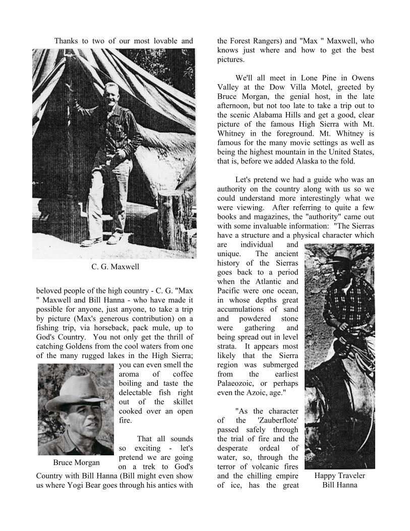
Thanks to two of our most lovable and
beloved people of the high country - C. G. "Max " Maxwell and Bill Hanna - who have made it possible for anyone, just anyone, to take a trip by picture (Max's generous contribution) on a fishing trip, via horseback, pack mule, up to God's Country. You not only get the thrill of catching Goldens from the cool waters from one of the many rugged lakes in the High Sierra;
you can even smell the aroma of coffee boiling and taste the delectable fish right out of the skillet cooked over an open fire.
That all sounds
so exciting - let's pretend we are going on a trek to God's
Country with Bill Hanna (Bill might even show us where Yogi Bear goes through his antics with
the Forest Rangers) and "Max " Maxwell, who knows just where and how to get the best pictures.
We'll all meet in Lone Pine in Owens
Valley at the Dow Villa Motel, greeted by Bruce Morgan, the genial host, in the late afternoon, but not too late to take a trip out to the scenic Alabama Hills and get a good, clear picture of the famous High Sierra with Mt. Whitney in the foreground. Mt. Whitney is famous for the many movie settings as well as being the highest mountain in the United States, that is, before we added Alaska to the fold.
Let's pretend we had a guide who was an
authority on the country along with us so we could understand more interestingly what we were viewing. After referring to quite a few books and magazines, the "authority" came out with some invaluable information: "The Sierras have a structure and a physical character which are individual and unique. The ancient history of the Sierras goes back to a period when the Atlantic and Pacific were one ocean, in whose depths great accumulations of sand and powdered stone were gathering and being spread out in level strata. It appears most likely that the Sierra region was submerged from the earliest Palaeozoic, or perhaps even the Azoic, age."
"As the character of the 'Zauberflote' passed safely through the trial of fire and the desperate ordeal of water, so, through the terror of volcanic fires and the chilling empire of ice, has the great
C. G. Maxwell
Happy Traveler Bill Hanna
Bruce Morgan

! #!
Sierra come into the present age of tranquil grandeur."
"Five distinct periods divide the
history of the range. First, the slow gathering of marine sediment within the early ocean during which incalculable ages were consumed. Second, in the early Jurassic period this level sea-floor came suddenly to be lifted into the air and crumpled in folds, through whose yawning fissures and raptured axes outpoured wide zones of granite. Third, the volcanic age of fire and steam. Fourth, the glacial period, when the Sierra was one broad field of snow, with huge dragons of ice crawling down its slopes, and wearing their armor into the rocks. Fifth, the present condition ... this serrated snow and granite outline of the Sierra Nevada, projected against the cold clear blue, is the blade of white teeth which suggested its Spanish name."
It has been said that the Sierra was a
"land born of fire and sculptured by ice ... " Mt. Whitney, named after Professor Whitney, is 14,496 feet and the tallest peak in the continental United States. King, back in 1873, on an expedition to climb Mt. Whitney, ended up on Mount Langley, 450 feet lower, but it wasn't until August 4, 1873, in the "Proceedings
of the California Academy of Sciences" by W.A. Goodyear that the truth came out.
The Alabama Hills are as interesting as Mt. Whitney in many aspects. Some have ascertained that they are even older than the Sierra range itself. "They lie about two hundred miles north of Los Angeles on the
arid desert between the High Sierra and the Inyo Mountain ranges. They are a unique formation of rocks with an incongruously, out-of-the-state name:
'The Alabama Hills.'
The Alabama Hills are between Lone Pine, California, and Mt. Whitney, on either side of the road to the Mt. Whitney Portals, where the climb to Mt. Whitney commences.
The Hills got their name during the
Civil War period from a group of Owens Valley pioneers whose sympathies were with the South. An English-built ship, the "Alabama," commanded under a commission from the Confederacy carried on a career of heavy destruction against the Union. This havoc on the seas continued until June 19, 1864, when
It has been said that the Sierra was a "land born of fire and sculptured by ice ... " Mt. Whitney, named after Professor
Mt. Whitney in many aspects. ascertained that they Sierra range itself. hundred miles north of Los Angeles on the
'
Mt. Whitney and the Alabama Hills.
#Loading up at Cottonwood Pack Station

5
a crack war ship of the Union, the “Kearsarge” caught up with the "Alabama" off the Cherbourg coast of France. It was at this time that the group of Owens Valley pioneers, in admiration of the havoc wrought by the "Alabama" against the Union, named the grotesque and weird rock formation the Alabama Hills.
It was growing dusk when we returned to
Lone Pine – we could look back up to the grandeur of the Sierra and marvel at their history, but the fresh air and hike gave us an appetite. Those steaks at Carl’s Sierra Cafe
really filled the bill or at least that empty cavity in my "middle."
We must get to bed early so as to get a
good, early start for our trek up the hill to God's Country, and to that spot where we can have a hot, delicious lunch and rest our weary bones, Golden Trout Camp, after a four-hour horseback ride. We do get to bed early, up at 6:30; off to a good breakfast at the Mt. Whitney Cafe; then on up to Cottonwood Pack Station. The pack station is located about equally between
Olancha and Lone Pine and the turnoff can be easily seen by a big sign off the highway, "HOME OF THE GOLDEN TROUT - GOLDEN TROUT CAMP, COTTONWOOD LAKES, via COTTONWOOD PACK STATION." I'm certain our trusty hosses and pack mules are waiting.
The Cottonwood Pack Station was first
started by an ol' character by the name of Barney Sears. The way Pat Shepard of "The Times" put it, away back in 1952 after an interview with Barney ... "Rounding up a string of mules and horses, Barney bought some land and established his first pack station on Cottonwood Creek in 1920. He's been there ever since. While he's made a host of friends among the thousands of businessmen, government officials and the vacationists he's packed into the High Sierra wilderness, he's been back to Los Angeles only twice in the last 26 years ... " Some of those vacationists could tell a tale or two about their experiences with Barney and his loco horses, etc. Leo Rogers of Olancha worked for him as a packer for a while. Then, when Barney decided to "retire," Leo and his wife Merta bought him out.
Leo kept the station until his health
wouldn't allow him to go up in the high altitude. Ken Vinnedge bought him out and for several years brought the many rugged, nature lovin' vacationists up to the beautiful back country. His sister, Tiny, and husband, Bob Moore, helped out at the pack station until they "fell in love" with the country, and decided they would like to buy the station. This they did and they have continued to run it very successfully. They were so helpful to the owners of Golden Trout Camp

! %!
who were dependent on them for mail, supplies and, of course, contented guests.
Coming back to our make-believe trip
with "Max" and Bill - the packers put all of our gear on old Mollie and Geraldine mules, the most trustful ol' pack animals and perhaps even the most lovable. that is, as lovable as mules can be. The pack station gave "Bucky" and "Chocolate" to Bill and Max. We started off around 8 a.m., with Bill acting as mule skinner. For the first hour, we all jogged along rather slowly up the trail along the beautiful Cottonwood stream - sometimes in awe of the surging, swirling, turbulent water and then pensive at the sight of quiet, deep pools reflecting ferns or dew-dripped leaves of the cottonwood, various elms and even the gnarled oaks.
Of course, the trail of shale and sand, over and around rocks, is rugged and, as it was warm, we stopped to let the animals "blow" or get their wind. From around 4,500 feet at the pack station, we traveled up, up, up to eventually 10,200 feet in eight miles (which seems twice that long).
So you can understand why the trail is
quite steep. After we crossed the stream over the first bridge, we switched back and forth up almost to the "trail-crew camp." Not only the stock got thirsty, but we all did too. So when we crossed Little Cottonwood Stream, we decided to get a can of cool mountain water. Oh, it was so good and even Bill could verify that.
Back in the saddle, we passed by the trail-crew camp up across the new steel "5-mile" bridge (It replaced an old log bridge and later the ford through the swift stream.) By that time we were really getting up high, above the oak trees and pinon trees. We criss-crossed on the side of the mountain instead of going the difficult "cow" trail following the stream up. Looking down on the canyon was a breath-taking sight. The trail took us back to view the roaring stream again - this time the water was tumbling over huge rocks, foaming at the
bottom, and in a big pool, we could see several trout scurrying to hide from eye and hook. On, on, up we climbed, across a bridge again and then, around a sharp switchback on the side of the mountain, we got our first view of a wooden structure ahead.
Ten minutes later, we were pulling up to
the old sawmill. It was so interesting that we dismounted, and tied up our horses and
mules to an old wagon, or what was left of it.
We looked closer at the
large solid wood, iron-rimmed wheels, the huge tongue that had been drawn by oxen to bring the
dismounted, and tied up our horses
mules to an old wagon, or what was left of it.
We looked closer at the
Sherman Stevens Sawmill

! &!
logs to the sawmill where they were sawed up in boards, floated down a flume down Cottonwood stream to eventually end up in the charcoal kilns and shipped on a boat over Owens Lake to the Cerro Gordo silver mines. To be more accurate, our "authority" quotes from an article by Hal Kleinschmidt. In June, 1873, Colonel Sherman Stevens built the sawmill and flume on Cottonwood Creek, high in the Sierras directly west of this spot. The flume connected with the Los Angeles bullion, road. The lumber from the flume was used in timbering in the mine and buildings and wood was turned into charcoal in these kilns, then hauled to Stevens' wharf east of here on Owens Lake. There it was put on the
steamers ‘Bessie Brady' and 'Molly Stevens,' hauled directly across the lake and from there wagons took it up the 'Yellow Grade' to Cerro Gordo, high in the Inyo Mountains above Keeler. M.W. Belshaw’s furnaces had used all available wood around the Cerro Gordo and this charcoal was necessary to continued production."
We looked closely at the abandoned sawmill, gradually decaying and falling prey to the elements. The sawmill was a work of art.
As far as we could determine, the timbers were put together with mortise and tenon and they fit perfectly. When one thinks of the conditions and lack of equipment they had
back in 1873, it is surprising such a feat could be attained. They must have abandoned it rather hurriedly, as we could sec huge logs ready to be rolled down the ramp into the, big, now rusty, buzz saw. The wagon was deteriorating rapidly, not only from the weather, but from souvenir hunters and stupid backpackers who have broken out the wheels and used the wood for a fire, even though plenty of firewood is within a few yards.
We decided to be on our way. So after
checking the cinches, saddles and the pack on the mules, we untied the stock and mounted same. The Saddle didn’t seem quite as hard as it did when we got off at the sawmill. We followed the stream up past the various turnoffs, always keeping the Cottonwood Creek on our left. By this time we were approaching the top of the steep climb, sometimes a one-time giant
Sand Dunes of Horseshoe Meadows
Cottonwood Lakes Backcountry
Cottonwood Lakes Trail

! '!
of a tree that had been invaded by pine beatles (always a forest's worst enemy) or struck by lightning stood out like a sentinel, silhouetted against the bare, blue sky. We noticed as we
plodded along, that the trail had turned to sand and shale. We were up on top and could see miles around the various mountain peaks. We were still following the stream, past the beaver ponds and the turnoff to Horseshoe Meadows and Mulkey Meadows.
One could see the roots of large pine trees that had been felled during the winter and spring. The big pine trees would accumulate a load of snow on their branches. A rain might soften the ground and then another snowfall would freeze, making the tree branches heavy.
The wind would accomplish, the rest. Very few dead trees ever blew over.
The trail that
leads across the sand dunes goes near, too near for my well-being, to the edge of the sand dunes in several places. Glancing out of the corner of my eye, I
could see down a steep precipice to the stream below. The stream lazily weaved its way own
through the meadow and the water was slowly meandering along. I could see little Golden fish darting here and there with the sound of the horses' hooves above them, and even a few
grains of sand avalanched down the slope to frighten the little creatures.
I've always wondered if any horse had
side-stepped and gone over - never the pack mules, as they are smart and sure-footed. (Mules are so smart by instinct. I've learned, that they will never gorge themselves on grain, never drink too much water especially when they're over-heated; never get into a bog; and will back all of this up by getting the reputation of being stubborn and ornery.)
Anyway, we made it across the eerie strip,
on in sight of the first gate, assuring us we had traveled the hardest part of the trip.
Horseshoe Meadows Trail to Mulkey Meadows and Trail Peak
Golden Trout Camp

! (!
Once inside the gate we rode through a meadow and a grove of pines. Gooseberry vines and wild flowers peered up at us as we jogged along. As we rode through a pile of rocks extending across the stream, we were curious as to rocky terrain. We later heard that a certain tribe of Indians made their homes there. Many arrowheads, pieces of pottery and relics had been found, stirring the imagination about a way of life many, many years ago.
Following the
stream, we were in view of the second gate and we knew it was only a matter of minutes until we would reach our destination and the warm hospitality awaiting us at Golden Trout Camp. We dismounted, none too soon, and found our
"under-pinnings" wobbly and our knees bent out of shape. Sure enough, we were greeted by the whole O'Keefe clan and camp personnel, genuinely happy to see their ol' friends again. The boys carried our gear to our tents and supplied us with hot water to wash in and that cold, delicious spring water for a long-anticipated drink. We were revived with a hot lunch only the O'Keefes could serve.
Oh, it was wonderful to be back in God's
Country again and get! our lungs full of good, clean air and take a minute to view the grandeur of the stream, the willow bushes outlining a green meadow, lines of pine trees with Mt. Langley in the background silhouetted against a blue, blue sky.
Cottonwood Lake #1
green meadow, lines of pine trees with Mt. Langley in the
! )*!
We "tied" into a most delicious lunch consisting of a tuna casserole, toasted garlic bread, a tossed crisp green salad, and for dessert, custard with real whipped cream. The cream was supplied through and with the efforts of one Jersey cow. Daisy Mae.
While eating we were given a detailed
report of the best spots to fish, the surrounding country and a history of that little retreat nestled way up among the trees and tall mountain peaks, namely Golden Trout Camp. This is the way the story went, just by hearsay, but interesting. About 45 to 50 years ago, old man Anton sat in front of his log cabin and watched the cattle, brought up from the Owens Valley ranches, graze during the summer months. Gradually hikers and backpackers went by, stopping to pass the time of day and rest, or pick up some groceries which the old man kept on
hand. They would give him a list of needed items and he would tell them to help themselves. If he was in a good mood, he would just glance at them,
grunt and quote whatever price he deemed adequate. More and more people invaded the wilderness and enjoyed the fishing in more than
a dozen lakes around, some known as the Cottonwood Lakes.
In the 1920s, Clarence Towler, a
handsome, soft-spoken gentleman, and his nice wife came up, laid eyes on this beautiful spot and fell in love with it. They acquired the camp, what little there was of buildings, etc., and leased from the Government about 350 acres of land around the cabin.
After making the necessary arrangements,
the Towlers spent their first night in the log cabin. The cabin was a shelter after a fashion. The floor was dirt, the snow was falling that night and before morning it had drifted in through the cracks between the logs onto their bed. With two people like the Towlers, putting all of their energies and love of the country together, they began building a haven for outdoor and nature lovers including fishermen. They put in a cement floor, filled in the chinks of the cabin, had a log cabin built for the laundry and two showers. They added more tents, some housekeeping to accommodate the increasing number of visitors.
Frank Chrysler and Ted Cook operated a
pack station down in the valley by Carrol Creek. They would bring supplies in to Golden Trout Camp, as well as guests who preferred riding to
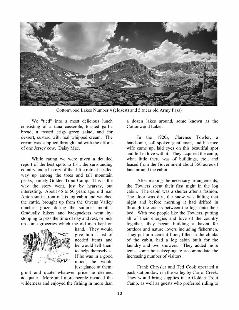
Cottonwood Lakes Number 4 (closest) and 5 (near old Army Pass)

! ))!
hiking. Later they even brought up two or three wooden boats for fishermen on lakes no. 4 and no. 5. Eventually, Bruce Morgan bought out Chrysler & Cook and ran the Mt Whitney Pack
Trains. In 1920 Barney Sears, a half-brother of Mr. Towler, acquired land and stock at the Cottonwood Stream outlet and set up the Cottonwood Pack Station.
Many years passed with more and more
people coming up; more and more people enjoyed the graciousness and beauty of the Towlers and the country. But there comes a time when all good things come to an end, or so many guests of the Towlers thought. They decided to sell the camp, and that they did to a Howard E. Davies of Lone Pine. Davies took over the camp in 1946 and operated it for one year. His sudden death forced the Towlers to take it back.
It seems there had been a young family
coming up for several years that also loved the country and the camp. In the fall of 1949, the John O'Keefes convinced the Towlers they would carry on in the same manner, and so the O'Keefes took over Golden Trout Camp. The George Andrews managed the camp the summer of 1950. After that, the O'Keefe family carried on nobly every summer.
Getting back to our trip to God's Country
with Bill and Max - after lunch Bill decided to try his luck in the pool in camp. (A slight dam
in the Cottonwood Stream built by the boys afforded a quiet little pool for fishing and rafts.) He caught enough stream Goldens for snacks, fried by the cook, before dinner. Speaking of dinner, one can enjoy E.J.'s home-cooked food, like fresh vegetable soup; fruit jello salad; roast beef, gravy; mashed potatoes; stewed tomatoes; and warm apple pie and the best coffee. Oh, boy, what delicious food and so much and it's served family style!
We'll all stop by the campfire before
retiring, perhaps sing a few songs with Johnnie, Kathy and the gang. The fresh air and exercise makes one sleepy, so off to bed. Up bright and early and we're hungry as a bear. We can alleviate that feeling with E.J.'s cooking-fruit, ham, eggs, sour cream hotcakes and coffee. We'll have to make that trek over the hill first before we can get our fishing gear ready. All set!
'Back on our noble steeds-oh, that sore
spot and those stiff legs, but nothing daunts us as we head for the many lakes. Bill and "Buck" lead the way, but "Huck" wants to turn and go back to camp - a little persuasion with a willow will turn him around.
The closest lake is about two-and-a-half
miles and takes the average rider about forty-five minutes. It is the first of the Cottonwood Lakes and naturally called "No. 1" Lake. It is
Cottonwood Lake No. 5 (closest) From Old Army Pass
Old Army Pass and Lake No. 5

! )"!
excellent for fly fishing the latter part of the summer.
There are a dozen lakes within a radius of
three miles. Many are above the timber line and nestled under the rugged Mt. Langley, once thought to be the highest mountain in the United States. Clarence King in searching for Mt. Whitney, mistook Mt. Langley for Mt. Whitney. Among the sea of peaks half seen, half storm-hidden, he recorded the altitude of 14,042 feet, which was Mt. Langley. Mt. Whitney's altitude was 14,496 feet and Mt. Langley is approximately 450 feet lower.
In any event, their grandeur is aweing and
makes one feel very small and humble. No. 2 Cottonwood Lake is small in
comparison, but has the most unique rock formations on one side. Lures will pull in the Goldens if you know where just the right holes are.
After eating our packed lunch, we decided
to take a sight-seeing trip. So from No. 2 Lake, we took off on a well-traveled trail up to Lake No. 3. It is the longest lake and we traveled along the side of the blue, beautiful lake. Looking across the lake, we could see the huge granite mountain looming up into the heavens. We decided to go on up to see the two deepest lakes in the Cottonwood group.
After going around the side and end of No. 3 we proceeded up a steep incline by switching
back and forth. Once on top we could look back and see just how long No. 3 was. On ahead, we could see two huge, almost barren lakes. They were so deep, the water looked blue-green and I heard that No. 5 was so deep in one spot that the depth could not be measured. (Now they would have instruments to measure it.) The Old Army Pass followed the trail around No. 4, with a series of switch-backs leading up about half-way and then veered to the left and continued along a ledge of almost solid rock, to the lowest draw on top. By turning to the right when once on top, one could ascend to the top of Mt. Langley. We were told that a good fisherman could catch the "granddaddies" Golden Trout from these two lakes. We had had our view of lakes for the day, and, besides, we had an hour's ride down to camp where we could get a nice, hot shower with that soft mountain spring water. It was even better than it sounded. With a huge appetite, we descended upon the dining room. There's a certain satisfaction of "All's right with the world" when one is full, physically tired, clean inside and out, warm and happy in a cozy tent.
Up bright and early the next morning and
after a hearty breakfast, we all decided to go to Muir Lake, named after the famous John Muir. While the well-known Muir trail doesn't come south to the Cottonwood area, it is over 200
Golden Trout Fish Fry
Cottonwood Lake No. 2

! )+!
miles north from Mt. Whitney to Yosemite Valley.
"Close to the crest of John Muir's Range
of Light and named in his honor lies the most famous - the John Muir Trail, which shuns the easy, lower routes in favor of the rugged passes and dazzling peaks of the High Sierra."
Muir Lake is the prettiest of all the lakes.
It is surrounded by tall pine trees on one side, a sandy beach on another and a good rocky spot where Bill and "Max” decided to cast out for a few beautiful Goldens. We didn't have long to wait until zzzzzu went the reel. Bill carefully played that resisting, fighting golden streak until he landed him up on the bank.
That was a thrill for all. With a big fire
going, I could almost smell those goldens sizzling in the pan. Sure enough, a few hours later, we were eagerly and hungrily waiting for the nice catch of fish to get done on both sides. Oh, the aroma was so tantalizing and we weren't disappointed. Out in the open air, with the smell of the wood fire, aroma of coffee and those fish would be the epitome of complete satisfaction.
There is nothing more beautiful than a
fresh catch of Golden Trout. “Golden Trout” which are native to waters
at the head of the South Fork of the Kern River, were first introduced into Inyo-Mono waters in
1893 by cattlemen. A few of the trout were carried from Mulkey Meadows in a coffee can and planted in the Cottonwood Lakes. From these lakes have since come most of the golden trout stock planted in hundreds of High Sierra
lakes and streams.” "The golden trout is the State fish.
Anglers prize it for its brilliant coloration, fighting qualities, and delicate taste (stemming from rich body fat)."
"It is a brilliantly colored trout with olive
green on the upper areas of the body giving way to pale lemon-yellow sides, then golden-yellow and vermilion or cherry red on the lower sides and belly. Gill covers and lower body fins often are bright red. Large back fin, belly and anal fins are often white-tipped bordered with black. Relative-ly few round black spots are generally confined to the back fins and tail with a scattering of spots forward onto the head. A typical golden has a row of roundish blotches (called parr marks) on the sides from the head to the tail through which extends a bright red band."
Catch of Golden Trout

! )#!
We wanted to see more of the lakes in that beautiful, rugged but magnificent country. So the next day we left on horseback as usual (by this time we were no longer considered "dudes" - that's a nasty word for softies) and we were either getting used to the saddle or we were plain numb. In any event, we made our way up to South Fork Lake, stopping at the crest to look down on the spectacular panorama ahead.
We tied up our noble steeds and threw in a line for another limit (not all at once or with a single line but with the efforts of all). This time we decided to take them back to camp for "Cook O'Keefe" to prepare for the other guests. After all, we wanted to share our "delicacies." It was getting overcast but we just had to see the other two lakes of the South Fork group.
To get to Long Lake and High Lake, we
had to pass through a trail of solid rock, or so it looked. We made it through the Rock Pile, up along the side of Long Lake, on up to the highest lake. Had we continued on the trail, it would have taken us over the new Army Pass, but we were content to dismount and walk around High Lake on foot, stopping at times to gaze up in awe and reverence at the rock formations reaching up to the heavens - truly a work of God and nature.
Leaving this rugged spot of
beauty, we retraced our steps down through the Rock Pile, beside No. 2 and No. 1 lakes, down via the newest trail, through the meadows, glancing up at the falls cascading down from the outlet of the first lake.
A deer and a fawn bounded
away, startled by the sound of our horses' hooves, with a grace and speed that was unbelievable. Farther down, a white snow rabbit darted across the trail. Jogging along, we could see the many beautiful wild flowers in the meadow and blooming along the stream.
All good things must come to an end - the
next morning we bade our genial hosts goodbye. Wending our way back down the trail through the meadows across the sand dunes, we saw the country from another angle - it was just as breath-taking as going up, especially the view of the old sawmill.
When we beheld the view from the top of
the mountain, we could hardly believe our eyes. There were the pastel colors of blue, pink and purple from the chemicals in Owens dry lake, the blue and purple hues of the White Mountains, across Owens Valley, the green pine trees, the rushing Cottonwood stream down in the ravine, the blue, blue sky above and the canyon below.
No wonder that every one who takes that
trip to God's Country comes away with a feeling of peace and serenity and a heart full of admiration and reverence for that "Someone" bigger than them.
On the Trail past Cottonwood Lake No. 2 to Old Army Pass