8.9a - describe the historical development of evidence ... · continental shelves are placed...
TRANSCRIPT

8.9A - describe the historical development of evidence that supports plate tectonic theory

› Theory of Plate Tectonics – the theory that pieces of Earth’s lithosphere are in constant motion on the asthenosphere.
› The motion in the mantle (the asthenosphere) is caused by convection currents.
› But how did this theory become the “one”?
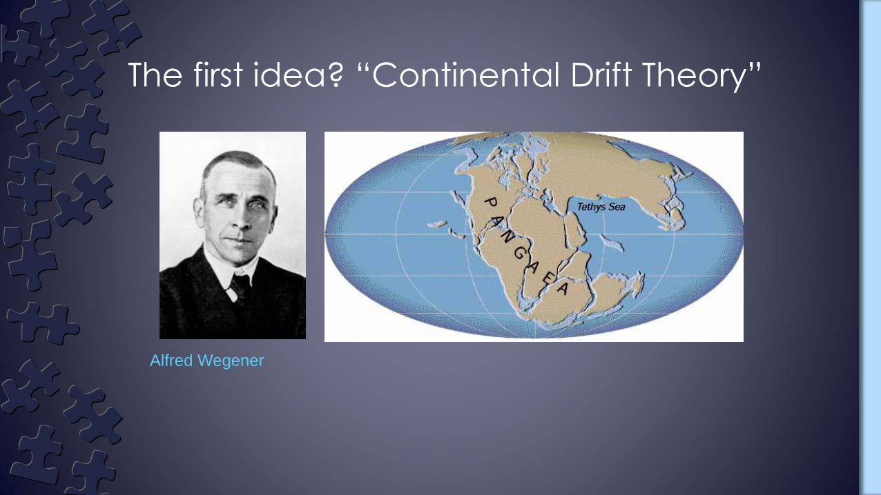
Alfred Wegener
The first idea? “Continental Drift Theory”

› His theory became known as continental drift theory
Previously, geologists believed
that the continents remained
fixed in their position
In 1912 Alfred Wegener
hypothesized that all the
continents had once been
joined together in a single
landmass and have since drifted
apart.
He named the landmass –
Pangaea, all lands


The continents are still slowly moving, at
about the speed your fingernails grow.
On average!
It’s important to remember that the
Earth is not a perfect sphere or ellipsoid,
and continents are not all moving at the
same rate.
But how did scientists determine that
they were moving at all?

› Wegener supported his theory with evidence from:
– Landforms
–Fossils
–Climate and Glacial

• Matching coastlines on different continents Today, we have a much better idea of the true outer
boundary of each continent by examining its continental shelf.
◦ The seaward edge of a continental shelf lies submerged below the ocean. When the edges of the continental shelves are placed together, the fit is remarkable.


› Wegener said that if we looked the shapes of the continents on a map, it seemed reasonable to suspect that they had all once been joined

› Mountain ranges and other features on the continents provided further evidence
–For example, the Appalachian mountains of eastern North America matched with the Scottish Highlands
–When these landmasses are reassembled on a map of Pangaea the mountain chains form a nearly continuous belt
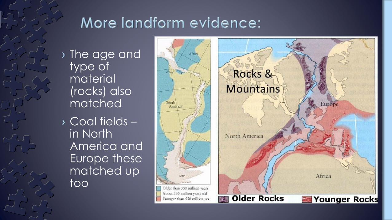
› The age and type of material (rocks) also matched
› Coal fields –in North America and Europe these matched up too

› Wegener found identical fossils on the matching coastlines of both South America and Africa.
–Wegener argued that South America and Africa must have at one time been joined.


› He found evidence for dramatic global climatic changes.
–Deep scratches on bedrock in Africa indicated that at one time it was covered in glaciers, which means it must have been much closer to the South Pole
› He also found that the fossils found in a certain place often indicated a climate utterly different from the climate of today
– i.e. tropical fossils in climates that currently have a harsh polar climate

› Glacial evidence showed up in places where the climate did not reflect such environments

› Evidence of past tropical climates in the Antarctic!

› As compelling as this evidence was, Wegener’s theory was not accepted by the scientific community.
– It would take another 50 years for this to occur.
› He could not provide a satisfactory explanation for the force that pushes or pulls the continents
› Wegner’s theory was largely ignored
› Evidence was need to convince scientists
› By the 1950s more and more evidence was beginning to be found.

Oceanographer in 1950s –
1990s
Marie Tharp produced one
of the world’s first maps of
the ocean floor.
Her observations became
crucial to the eventual
acceptance of the theories
of plate tectonics and
continental drift

Marie Tharp's "World Ocean Floor Map”
1977
She took the SONAR readings and working with only pens and rulers, drew the details of the ocean floor using longitude degree by latitude degree.
It was a technical process, but Marie got the task done. The first published map of the North Atlantic ocean was in 1957.
It was Tharp’s drawings that revealed that the ocean floor was not flat, but covered with features like canyons, ridges, and mountains just like on land.

› In the 1960’s, a scientist named Harry Hess made a discovery that would also vindicate Wegener.
› Using new technology, radar, he discovered that the seafloor has both trenches and mid-ocean ridges.
› Hess proposed that hot, less dense material below Earth’s crust rises toward the surface at the mid-ocean ridges.
› Then, it flows sideways, carrying the seafloor away from the ridge in both directions.
› Harry Hess called this the “Sea-floor spreading theory”.
Picture from USGS
http://pubs.usgs.gov/gip/dynamic/HHH.html

Echo Sounding Device Used By Hess

› At a divergent boundary, the plates move apart. Under the ocean, the seafloor spreads apart at what is called a mid-ocean ridge, as the plates move apart, new seafloor is created.
› Sea floor spreading is this process that molten material adds new oceanic crust to the ocean floor. The older seafloor is forced away from the ridge in opposite directions.

› Strange rocks shaped like pillows or like toothpaste squeezed from a tube have been found– These rocks can form only
when molten material hardens quickly after erupting under water
– These rocks showed that molten material has erupted again and again from cracks along the central valley of the mid-ocean ridge

› Scientists discovered that the rock that makes up the ocean floor lies in a pattern of magnetized “stripes”
› 780,000 years ago, magnetic poles reversed themselves (the average time between flips, which is highly variable, is 200,000 years– If they reversed today, the needle in a compass would point
south instead of north
› The rock in the ocean is made of iron, which began as molten material
Magnetic Reversals

› Plates move apart
› Magma rises and cools forming new sea-floor– Youngest rock is near the
ridge, it gets older as you move away
› The earth’s magnetic field is recorded in the rock as it forms
› We have a record of the earth’s magnetic reversals on either side of the ridge.


As distance from the (mid-ocean) ridge increases, the age and thickness of the sea-floor increases.

› The final proof of sea-floor spreading came from rock samples obtained by drilling into the ocean floor. The Glomar Challenger, a drilling ship built in 1968, gathered the samples.
› Then the scientists determined the age of the rocks in the samples. They found that the farther away from a ridge the samples were taken, the older the rocks were. The youngest rocks were always in the center of the ridges. This showed that sea-floor spreading really has taken place.

› We use different tools now to track plate movement and to continue making new discoveries
› Have you heard of the “new” continent?

Satellite measurements have confirmed that every year
the Atlantic Ocean gets a few inches wider (at the
Marianas Trench)!
› Scientists use GPS and satellite images to track movement
› Some of the things we have discovered:

› Australia is not quite where it used to be. The continent has shifted by 4.9 feet since the last adjustment was made to GPS coordinates in 1994.

› The plate that Australia sits on has been moving relatively fast, about 2.7 inches a year
› In contrast, the North American plate has been moving roughly one inch a year, though the Pacific plate moves three to four inches a year.
› The result is that “some countries are more stationary than others”
› Future predictions of
plate movement -