4.12 throckmorton reservoir
TRANSCRIPT

Initially Prepared 2016 Brazos G Regional Water Plan | Volume II
New Reservoirs | Throckmorton Reservoir
May 2015 | 4.12-1
4.12 Throckmorton Reservoir
4.12.1 Description of Option
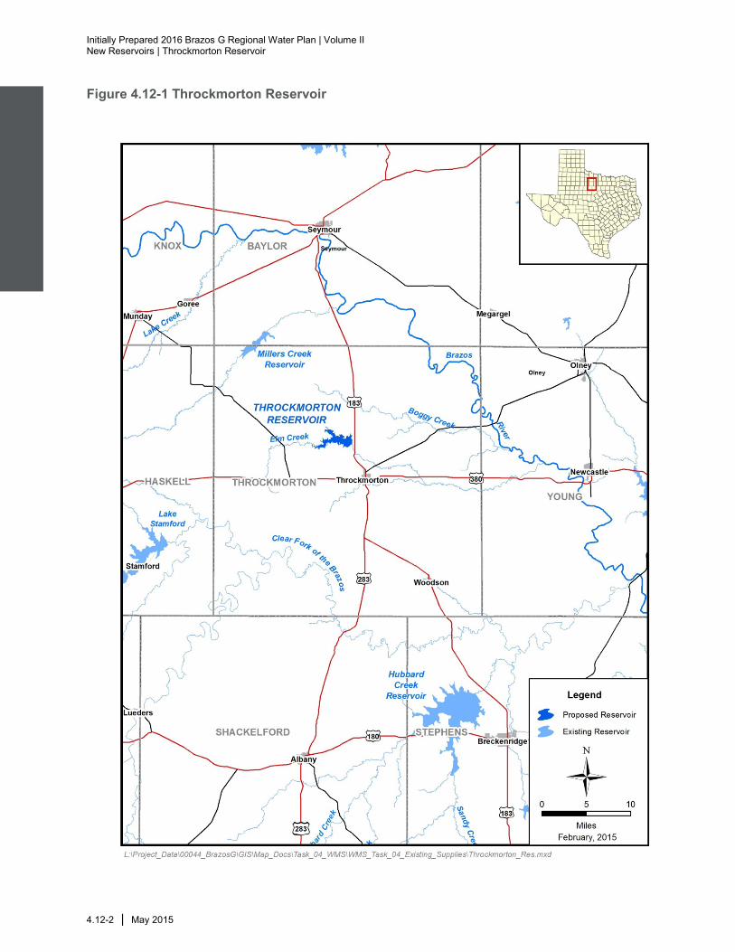
A potential water management strategy for the City of Throckmorton is a new reservoir
located approximately 3 miles northwest of the city as shown in Figure 4.12-1. The
proposed reservoir will be located on the North Elm Creek and will contain approximately
15,900 acft of conservation storage and inundate 1,161 acres at the full conservation
storage level of 1,345 ft-msl. The contributing drainage area is approximately 82 square
miles.
4.12.2 Available Yield
Water potentially available for impoundment in the proposed Throckmorton Reservoir
was estimated using a version of the TCEQ WAM Run 3. The model utilized a January
1940 through December 1997 hydrologic period of record. Estimates of water availability
were derived subject to general assumptions associated with TCEQ WAM Run 3. The
model computed the streamflow available from North Elm Creek without causing
increased shortages to existing downstream rights. Safe yield was computed subject to
the reservoir and North Elm Creek diversion having to pass inflows to meet
environmental flow standards associated with Senate Bill 3 (SB3).
The calculated safe yield of Throckmorton Reservoir is 3,540 acft/yr, assuming
subordination of Possum Kingdom Reservoir. According to the Brazos WAM, channel
losses between Throckmorton Reservoir and Possum Kingdom Lake are about 18%.
The firm yield of Possum Kingdom is reduced by an estimated 2,390 acft/yr. This
strategy has been evaluated with a subordination agreement with BRA for Possum
Kingdom Reservoir. Any subordination agreement with the BRA is dependent on the
BRA being able to successfully obtain the System Operation permit (See Section 7.12),
currently pending at the Texas Commission on Environmental Quality. A subordination
agreement would have to be negotiated and acquired for this strategy to be implemented
as presented in this section.
Figure 4.12-2 illustrates the simulated Throckmorton Reservoir storage levels for the
1940 to 1997 historical period, subject to the safe yield of 3,540 acft/yr. Figure 4.12-3
shows that simulated reservoir contents remain above 80 percent capacity about
46 percent of the time and above 50 percent capacity above 84 percent of the time.
Figure 4.12-4 illustrates the changes in North Elm Fork streamflows caused by
impounding unappropriated water. The largest changes would be declines in median
streamflow of 24 cfs during May and 21.8 cfs during June. Streamflow is reduced
significantly in all months. Figure 4.12-5 also illustrates the North Elm Creek streamflow
frequency characteristics with the Throckmorton Reservoir in place.
Initially Prepared 2016 Brazos G Regional Water Plan | Volume II New Reservoirs | Throckmorton Reservoir
4.12-2 | May 2015
Figure 4.12-1 Throckmorton Reservoir

Initially Prepared 2016 Brazos G Regional Water Plan | Volume II
New Reservoirs | Throckmorton Reservoir
May 2015 | 4.12-3
Figure 4.12-2 Throckmorton Reservoir Firm Yield Storage Trace
Figure 4.12-3 Storage Frequency at Safe Yield
0%
10%
20%
30%
40%
50%
60%
70%
80%
90%
100%
19
40
19
44
19
48
19
52
19
56
19
60
19
64
19
68
19
72
19
76
19
80
19
84
19
88
19
92
19
96
Pe
rce
nt
Co
ns
erv
ati
on
Sto
rag
e C
ap
acit
y
Date
Safe Yield = 3,540 acft/yr
0%
10%
20%
30%
40%
50%
60%
70%
80%
90%
100%
0% 20% 40% 60% 80% 100%
Pe
rce
nt
Co
ns
erv
ati
on
Sto
rag
e C
ap
acit
y
Percent Time Storage Percentage Exceeded
Subject to diversion of the safe yield (3,540 acft/yr), storage in the Thockmorton Reservoir would be more than 80 percent full about 46 percent of the time and more than 50 percent full about 84 percent of the time.

Initially Prepared 2016 Brazos G Regional Water Plan | Volume II New Reservoirs | Throckmorton Reservoir
4.12-4 | May 2015
Figure 4.12-4 North Elm Fork Diversion - Median Streamflow Comparison
Figure 4.12-5 North Elm Fork Diversion- Streamflow Frequency Comparison
0
5
10
15
20
25
Jan Feb Mar Apr May Jun Jul Aug Sep Oct Nov Dec
Med
ian
Str
eam
flow
(cf
s)
Month
Without Reservoir
With Reservoir
0
50
100
150
200
250
300
350
400
450
500
550
600
650
0% 10% 20% 30% 40% 50% 60% 70% 80% 90% 100%
Str
ea
mfl
ow
(c
fs)
Percent Time Streamflow Exceeded
Without Reservoir
With Reservoir
Initially Prepared 2016 Brazos G Regional Water Plan | Volume II
New Reservoirs | Throckmorton Reservoir
May 2015 | 4.12-5
4.12.3 Environmental Issues
Existing Environment
The Throckmorton Reservoir site in Throckmorton County is within the Rolling Plains
Ecological Region1. This region is located east of the High Plains, west of the Cross
Timbers and Prairies, and north of the Edwards Plateau. It is characterized by nearly
level to rolling topography, soft prairie sands and clays, and alternating woodlands and
prairies. The physiognomy of the region varies from open, short to tall, scattered to
dense grasslands to savannahs with bunch grasses. Most of the plains are rangeland,
but cultivated crops are important in certain localities. Poor range management practices
of the past have increased the density of invasive woody plant species and have
decreased the value of the land for cattle production. Farming and grazing practices
have also reduced the abundance and diversity of wildlife in the region2. The climate is
characterized as subtropical subhumid, with hot summers and dry winters. Average
annual precipitation is approximately 27 inches.3
The Seymour aquifer, an unconsolidated sand and gravel aquifer, is the only major
aquifer in the county, but does not underlie the proposed reservoir site.4 The aquifer
consists of Quaternary-age, alluvial sediments unconformably overlying Permian-age
rocks. Water is contained in isolated patches of alluvium as much as 360 feet thick.
Water ranges from fresh to slightly saline. Most of the groundwater pumped from the
aquifer (about 90%) is used for irrigation, with the remainder used primarily for municipal
supply.5
The region lies within the North-Central Plains physiographic region which includes
elevations between 900 and 3,000 feet above sea level. Bedrock includes limestones,
sandstones, and shales. Where shale bedrock prevails, meandering rivers traverse
stretches of local prairie. In areas of harder bedrock, hills and rolling plains dominated.
Local areas of hard sandstones and limestones cap steep slopes severly dissected near
rivers.6 The predominant soil types in the project area are the Clearfork silty clay loam,
occasionally flooded and Lueders-Throck complex, 1-8 percent slopes, extremely stony.
The Clearfork silty clay loams are very deep, well drained soils present on floodplains on
draws. These soils are considered prime farmland soils. The Lueders-Throck complex
soils are soils are generally found on hillslopes on ridges and are derived from gravelly
residuum weathered from limestone. These soils are well drained and are not
considered prime farmland. Other soils comprise a smaller portion of the project area.
These include Leeray clay, 0 to 1 percent slopes, Lueders cobbly loam, 1 to 5 percent
slopes, Lueders-Springcreek complex, 1 to 8 percent slopes, very stony, Nukrum clay
1 Gould, F.W., G.O. Hoffman, and C.A. Rechenthin, Vegetational Areas of Texas, Texas A&M University,
Texas Agriculture Experiment Station Leaflet No. 492, 1960. 2 Telfair, R.C., Texas Wildlife Resources and Land Uses, University of Texas Press, Austin, Texas, 1999.
3 Texas Almanac, 2008. Texas Almana 2008-2009. The Dallas Morning News Inc., Dallas, TX 2008.
4 Texas Water Development Board (TWDB), Major and Minor Aquifers of Texas, Maps online at
http://www.twdb.texas.gov/groundwater/aquifer/major.asp, accessed November 25, 2004. 5 TWDB, Seymour Aquifer, http://www.twdb.texas.gov/groundwater/aquifer/majors/seymour.asp,
accessed November 25, 2014. 6 Wermund, E.G., Physiographic Map of Texas, Bureau of Economic Geology, University of Texas,
Austin, Texas, 1996. Accessed online at http://www.beg.utexas.edu/UTopia/images/pagesizemaps/physiography.pdf on November 25, 2014.

Initially Prepared 2016 Brazos G Regional Water Plan | Volume II New Reservoirs | Throckmorton Reservoir
4.12-6 | May 2015
loam, 1 to 3 percent slopes, Nuvalde clay loam, 0 to 1 percent slopes, Nuvalde clay
loam, 1 to 3 percent slopes, Owens-Harpersville complex, 8 to 45 percent slopes,
extremely bouldery, Owens-Lueders complex, 5 to 30 percent slopes, extrememly
bouldery, Rowden clay loam, 0 to 2 percent slopes, Rowena clay loam, 0 to 1 percent
slopes, Sagerton clay loam, moist, 1 to 3 percent slopes, Speck silty clay loam, 0 to 2
percent slopes, Springcreek clay loam, 1 to 3 percent slopes, and Throck silty clay loam,
1 to 5 percent slopes. Of these soils, approximately 46 percent are considered to be
prime farmland soils.7
Two major vegetation types occur within the general vicinity of the proposed project:
Mesquite (Prosopis glandulosa)–Lotebush Shrub, and crops.8 Variations of these
primary types occur involving changes in the composition of woody and herbaceous
species and physiognomy according to localized conditions and specific range sites.
Mesquite-Lotebush Shrub could include the following commonly associated plants: yucca
(Yucca spp.), skunkbush sumac (Rhus trilobata), agarito (Berberis trifoliolata),
elbowbush (Forestiera angustifolia), juniper, tasajillo (Opuntia leptocaulis), cane
bluestem (Bothriochloa barbinodis), silver bluestem (Bothriochloa saccharoides), little
bluestem (Schizachyrium scoparium), sand dropseed (Sporobolus cryptandrus), Texas
grama (Bouteloua rigidiseta), sideoats grama (Bouteloua curtipendula), hairy grama
(Bouteloua hirsuta), red grama (Bouteloua trifida), tobosagrass (Pleuraphis mutica),
buffalograss (Buchloe dactyloides), Texas wintergrass (Nasella leucotricha), purple
three-awn (Aristida purpurea), Engelmann daisy (Engellmania peristena), broom
snakeweed (Gutierrezia sarothrae), and bitterweed (Hymenoxys odorata). Crops include
cultivated cover crops or row crops providing food and/or fiber for either man or domestic
animals and may also include grassland associated with crop rotations and hay
production.
Potential Impacts
Aquatic Environments including Bays and Estuaries
The anticipated impact of this project would be minimal reduction in variability and
substantial reductions in quantity of median monthly flows. The reduction in variability of
monthly flow values would probably not have much impact on the instream biological
community or riparian species. However, there would be a reduction in the quantity of
median monthly flows downstream of the project ranging from 2.3 cfs in January to 24
cfs in May, as shown in Table 4.12-1. The highest reductions (>10 cfs) would occur in
May and June, and all months would have significant reductions in flow. This project
would also result in a higher frequency of low-flow conditions. Without the project, the
monthly flow would be less than 0.71 cfs only 15 percent of the time (85 percent
exceedance value), and would be less than 0.71 cfs 90 percent of the time with the
project in place. These reductions in flow would have substantial impacts on the
instream biological community, especially since the greatest reductions are predicted for
7 Natural Resources Conservation Service, Custom Soil Resource Report for Throckmorton County,
Texas, United States Department of Agriculture, Natural Resources Conservation Service, in cooperation with Texas Agricultural Experiment Station, November 25, 2014. 8 McMahan, C.A., R.F. Frye, and K.L. Brown, The Vegetation Types of Texas, Texas Parks and Wildlife
Department, Wildlife Division, Austin, Texas, 1984.

Initially Prepared 2016 Brazos G Regional Water Plan | Volume II
New Reservoirs | Throckmorton Reservoir
May 2015 | 4.12-7
the summer months when flows are already historically low and water chemistry
conditions are the most stressful for aquatic species (e.g., high temperatures and high
nutrient growth).
Although there would be biological impacts in the immediate vicinity of the project site
and downstream, it is not likely that this project, alone, would have a substantial
influence on total discharge in the Brazos River or to freshwater inflows to the Brazos
River estuary. However, the cumulative impact of multiple projects may reduce
freshwater inflow to the estuary. As a new reservoir without a current operating permit,
the Throckmorton Reservoir would likely be required to meet environmental flow
requirements determined by site-specific studies.
Table 4.12-1 Median Monthly Streamflow: North Elm Creek Diversion Site
Month Without Project (cfs)
With Project (cfs)
Difference (cfs)
Percent Reduction
January 2.3 0.0 2.3 100%
February 2.4 0.0 2.4 100%
March 2.9 0.0 2.9 100%
April 2.7 0.0 2.7 100%
May 24.0 0.0 24.0 100%
June 21.8 0.0 21.8 100%
July 4.7 0.0 4.7 100%
August 4.7 0.0 4.7 100%
September 6.8 0.0 6.8 100%
October 8.9 0.0 8.9 100%
November 4.3 0.0 4.3 100%
December 2.5 0.0 2.5 100%
Threatened & Endangered Species
A total of 14 species potentially occur within Throckmorton County that are state- or
federally-listed as threatened or endangered, candidates for listing, or exhibit sufficient
rarity to be listed as a species of concern (Table 4.12-2). This group includes 12 birds
and two fishes. The least tern (Sterna antillarum), piping plover (Charadrius melodus),
red knot (Calidris canutus rufa), Sprague’s pipit (Anthus spragueii), and whooping crane

Initially Prepared 2016 Brazos G Regional Water Plan | Volume II New Reservoirs | Throckmorton Reservoir
4.12-8 | May 2015
(Grus Americana) are federally-listed threatened, endangered, candidate or potentially
threatened bird species potentially occurring in the project area. The least tern is a
potential resident who nests along braided streams and could be affected by the
proposed reservoir. The piping plover, red knot, Sprague’s pipit, and whooping crane
are all migrants that could pass through the project area but would not likely be directly
affected by the proposed reservoir. The sharpnose shiner (Notropis oxyrhincus) is a
federally-listed endangered fish potentially occur in the project area.
No documented occurrences of any state or federally listed threatened, endangered, or
candidate species or species of concern were revealed within at least 2.5 miles of the
proposed Throckmorton Reservoir during a search of the Texas Natural Diversity
Database9 maintained by TPWD (as noted on representative 7.5 minute quadrangle
map(s) that include the project site). This data is not a representative inventory of rare
resources or sensitive sites. Although based on the best information available to TPWD,
these data do not provide a definitive statement as to the presence, absence, or
condition of special species, natural communities, or other significant features in the
project area. On-site evaluations will be required by qualified biologists to confirm the
occurrence of sensitive species or habitats.
Table 4.12-2 Endangered, Threatened, Candidate and Species of Concern Listed for Palo Pinto County
Common Name Scientific Name
Summary of Habitat Preference USFWS Listing
TPWD Listing
Potential Occurrence in County
BIRDS
American Peregrine
Falcon
Falco peregrinus
anatum
Migrant and local breeder in West Texas.
DL T Possible Migrant
Arctic Peregrine Falcon
Falco peregrinus
tundrius
Migrant throughout the state. DL -- Possible Migrant
Baird’s Sparrow Ammodramus bairdii
Shortgrass prairie with scattered low bushes; mostly migrant in
western half of State.
-- -- Possible Migrant
Bald Eagle Haliaeetus leucocephal
us
Primarily found near waterbodies. DL T Nesting/ Migrant
Least Tern Sterna antillarum
Interior population. Nests along sand and gravel bars in braided
streams
LE E Resident
Mountain Plover
Charadrius montanus
Nests on high plains or shortgrass prairie, on ground in shallow depression. Non-breeding in
shortgrass plains and bare, dirt fields.
-- -- Migrant
9 Texas Parks and Wildlife Department (TPWD), Texas Natural Diversity Database, Element of
Occurrence Records, November 24, 2014.

Initially Prepared 2016 Brazos G Regional Water Plan | Volume II
New Reservoirs | Throckmorton Reservoir
May 2015 | 4.12-9
Table 4.12-2 Endangered, Threatened, Candidate and Species of Concern Listed for Palo Pinto County
Common Name Scientific Name
Summary of Habitat Preference USFWS Listing
TPWD Listing
Potential Occurrence in County
Peregrine Falcon
Falco peregrinus
Possible migrant. Subspecies not easily distinguishable so
reference is made to species level.
DL T Possible Migrant
Piping Plover Charadrius melodus
Migrant shorebird in Texas. T -- Possible Migrant
Red Knot Calidris canutus rufa
Migratory species within Texas. PT -- Possible Migrant
Sprague’s Pipit Anthus spragueii
Migrant in Texas in winter mid Sept. to early April. Strongly tied
to native upland prairie.
C -- Possible Migrant
Western Burrowing Owl
Athene cunicularia hypugaea
Open grasslands, especially prairie, plains and savanna,
sometimes in vacant lots near human habitation. Uses
abandoned burrows.
-- --
Whooping Crane
Grus americana
Potential migrant LE E Potential Migrant
FISHES
Sharpnose shiner
Notropis oxyrhynchus
Endemic to Brazos River drainage. Found in large rivers.
LE -- Resident
Smalleye shiner Notropis buccula
Endemic to upper Brazos River system and its tributaries. Found
in medium to large prairie streams with sandy substrate.
LE -- Resident
LE/LT=Federally Listed Endangered/Threatened DL=Federally Delisted C=Candidate for Federal Listing E, T=State Listed Endangered/Threatened Blank = Considered rare, but no regulatory listing status
TPWD, 2014. Annotated County List of Rare Species –Throckmorton County updated 9/4/2014. USFWS, 2014. Species Lists from http://ecos.fws.gov/tess_public/countySearch!speciesByCountyReport.action?fips=48447, accessed November 18, 2014.

Initially Prepared 2016 Brazos G Regional Water Plan | Volume II New Reservoirs | Throckmorton Reservoir
4.12-10 | May 2015
Wildlife Habitat
Approximately 1,160 acres are estimated to be inundated by the reservoir. Utilizing
Ecological Mapping Systems of Texas data10
, the projected wildlife habitat that will be
impacted includes dominantly mixed grass prairie (approximately 760 acres), mesquite
shrubland (approximately 470 acres), native invasive mesquite shrubland (approximately
430 acres), floodplain herbaceous vegetation (approximately 255 acres), and row crops
(approximately 250 acres). Other wildlife habitat types that would be impacted include
riparian herbaceous vegetation, native invasive juniper shrubland, floodplain hardwood
forest, native invasive juniper woodland, marsh and barren land.
A number of vertebrate species would be expected to occur within Throckmorton County
near the proposed reservoir site including many game and non-game animals. These
include 11 species of frogs and toads, 6 species of turtles, 10 species of lizards and
skinks, and 24 species of snakes. Additionally, 78 species of mammals could occur
within the site or surrounding region 11 in addition to an undetermined number of bird
species. A variety of fish species would be expected to inhabit streams and ponds within
the site, but with distributions and population densities limited by the types and quality of
habitats available.
Cultural Resources
A search of the Texas Historical Commission’s online database for the 2011 Regional
Water Plan identified no mapped cemeteries, historical markers, National Register of
Historic Places sites or districts or State historic sites within the proposed reservoir site.
A search of the Texas Archeological Sites Atlas database indicated that no archeological
sites have been documented within the general vicinity of the proposed reservoir.
However, the area has never been surveyed by a professional archeologist and the
absence of documented sites may reflect the lack of investigation rather than the
absence of archeological sites. Prior to reservoir inundation the project must be
coordinated with the Texas Historical Commission and a cultural resources survey must
be conducted to determine if any cultural resources are present within the conservation
pool. Any cultural resources identified during survey will need to be assessed for
eligibility for inclusion in the National Register of Historic Places (NRHP) or as State
Archeological Landmarks (SAL). Cultural resources that occur on public lands or within
the Area of Potential Effect of publicly funded or permitted projects are governed by the
Texas Antiquities Code (Title 9, Chapter 191, Texas Natural Resource Code of 1977),
the National Historic Preservation Act (PL96-515), and the Archeological and Historic
Preservation Act (PL93-291).
10
Texas Parks & Wildlife Department (TPWD), “Ecological Mapping Systems of Texas,” https://drive.google.com/folderview?id=0B32g5sG2VKbgbl9oOGlneUdMZjA&usp=sharing accessed November 21, 2014.
11 Davis, W.B., and D.J. Schmidly, The Mammals of Texas – Online Edition, Texas Tech University,
http://www.nsrl.ttu.edu/tmot1/Default.htm, 1997.

Initially Prepared 2016 Brazos G Regional Water Plan | Volume II
New Reservoirs | Throckmorton Reservoir
May 2015 | 4.12-11
Threats to Natural Resources
Threats to natural resources include lower stream flows, declining water quality, and
reduced inflows to reservoirs. This project would likely have increased adverse effects on
stream flow below the reservoir site as a reduction in the quantity of median monthly flow
is projected downstream, but the reservoir would also trap sediment and/or dilute
pollutants, providing some positive benefits to water quality immediately downstream.
These benefits could be offset by declines in dissolved oxygen through decreased flows
and higher temperatures during summer periods. The project is expected to have
negligible impacts to total discharge downstream and overall water quality in the Brazos
River.
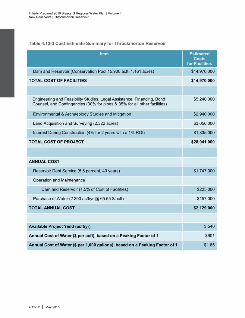
4.12.4 Engineering and Costing
Construction of the Throckmorton Reservoir project will cost approximately $28 million.
This includes the construction of the dam, land acquisition, resolution of conflicts,
environmental permitting and mitigation, and technical services. The annual project costs
are estimated to be $2.13 million; this includes annual debt service and operation and
maintenance. The cost for the available project safe yield of 3,540 acft/yr translates to
an annual unit cost of raw water of $1.85 per 1,000 gallons, or $601/acft. A summary of
the cost estimate is provided in Table 4.12-3. Costs shown herein are for raw water
supply at the reservoir and do not include transmission, local distribution, or treatment
costs. These costs include compensation to BRA for impacts of subordination of Possum
Kingdom Reservoir to Throckmorton Reservoir. Note that any subordination agreement
would need to be negotiated with BRA and is dependent on the BRA successfully
obtaining the System Operations permit from the TCEQ.
Initially Prepared 2016 Brazos G Regional Water Plan | Volume II New Reservoirs | Throckmorton Reservoir
4.12-12 | May 2015
Table 4.12-3 Cost Estimate Summary for Throckmorton Reservoir
Item Estimated Costs
for Facilities
Dam and Reservoir (Conservation Pool 15,900 acft; 1,161 acres) $14,970,000
TOTAL COST OF FACILITIES $14,970,000
Engineering and Feasibility Studies, Legal Assistance, Financing, Bond Counsel, and Contingencies (30% for pipes & 35% for all other facilities)
$5,240,000
Environmental & Archaeology Studies and Mitigation $2,940,000
Land Acquisition and Surveying (2,322 acres) $3,056,000
Interest During Construction (4% for 2 years with a 1% ROI) $1,835,000
TOTAL COST OF PROJECT $28,041,000
ANNUAL COST
Reservoir Debt Service (5.5 percent, 40 years) $1,747,000
Operation and Maintenance
Dam and Reservoir (1.5% of Cost of Facilities) $225,000
Purchase of Water (2.390 acft/yr @ 65.65 $/acft) $157,000
TOTAL ANNUAL COST $2,129,000
Available Project Yield (acft/yr) 3,540
Annual Cost of Water ($ per acft), based on a Peaking Factor of 1 $601
Annual Cost of Water ($ per 1,000 gallons), based on a Peaking Factor of 1 $1.85

Initially Prepared 2016 Brazos G Regional Water Plan | Volume II
New Reservoirs | Throckmorton Reservoir
May 2015 | 4.12-13
4.12.5 Implementation Issues
This water supply option has been compared to the plan development criteria, as shown
in Table 4.12-4, and the option meets each criterion.
Potential Regulatory Requirements:
• Texas Commission on Environmental Quality Water Right and Storage permits;
• U.S. Army Corps of Engineers Permits will be required for discharges of dredge or fill
into wetlands and waters of the U.S. for dam construction, and other activities
(Section 404 of the Clean Water Act);
• Texas Commission on Environmental Quality administered Texas Pollutant
Discharge Elimination System Storm Water Pollution Prevention Plan;
• General Land Office Easement if State-owned land or water is involved; and,
• Texas Parks and Wildlife Department Sand, Shell, Gravel and Marl permit if state-
owned streambed is involved.
State and Federal Permits may require the following studies and plans:
• Environmental impact or assessment studies;
• Wildlife habitat mitigation plan that may require acquisition and management of
additional land;
• Flow releases downstream to maintain aquatic ecosystems;
• Assessment of impacts on Federal- and State-listed endangered and threatened
species; and,
• Cultural resources studies to determine resources impacts and appropriate mitigation
plan that may include cultural resource recovery and cataloging; requires
coordination with the Texas Historical Commission.
• Coordination with BRA on any potential subordination agreement, subject to
availability under the System Operations permit.
Land Acquisition Issues:
• Land acquired for reservoir and/or mitigation plans could include market transactions
and/or eminent domain;
• Additional acquisition of rights-of-way and/or easements may be required; and
Possible relocations or removal of residences, utilities, roads, or other structures

Initially Prepared 2016 Brazos G Regional Water Plan | Volume II New Reservoirs | Throckmorton Reservoir
4.12-14 | May 2015
Table 4.12-4 Evaluations of Throckmorton Reservoir Option to Enhance Water Supplies
Impact Category Comment(s)
A. Water Supply
1. Quantity 1. Sufficient to meet needs
2. Reliability 2. High reliability
3. Cost 3. Reasonable
B. Environmental factors
1. Environmental Water Needs 1. Moderate impact
2. Habitat 2. High impact
3. Cultural Resources 3. High impact
4. Bays and Estuaries 4. Negligible impact
5. Threatened and Endangered Species 5. Low impact
6. Wetlands 6. Low impact
C. Impact on Other State Water Resources • No apparent negative impacts on state water resources; no effect on navigation
D. Threats to Agriculture and Natural Resources
• Potential impact on bottomland farms and habitat in the reservoir area
E. Equitable Comparison of Strategies Deemed Feasible
• Option is considered to meet municipal and industrial shortages
F. Requirements for Interbasin Transfers • Not applicable
G. Third Party Social and Economic Impacts from Voluntary Redistribution
• None