38th & blake station area - denver · 38th & blake station area and the surrounding ndcc...
TRANSCRIPT

38th & Blake Station AreaHeight AmendmentsFINAL DRAFT
AUGUST 25, 2016

38th & Blake Height Amendments
AcknowledgementsMAYOR MICHAEL B. HANCOCK
DENVER CITY COUNCIL
District 1 - Rafael Espinoza
District 2 - Kevin Flynn
District 3 - Paul D. Lopez
District 4 - Kendra Black
District 5 - Mary Beth Susman
District 6 - Paul Kashmann
District 7 - Jolon Clark (President Pro Tem)
District 8 - Chris Herndon
District 9 - Albus Brooks (President)
District 10 - Wayne New
District 11 - Christopher Herndon
At- Large- Robin Kniech
At-Large - Deborah Ortega
DENVER PLANNING BOARD
Jim Bershof
Ignacio Correa-Ortiz
Don Elliott
Renee Martinez-Stone
Joel Noble, Vice Chair
Susan Pearce
Frank Schultz
Chris Smith
Susan Stanton
Arleen Taniwaki
Julie Underdahl, Chair
THE 38th & BLAKE PLAN AMEND-MENT STEERING COMMITTEE:
Special thanks to the dedicated volunteer committee of residents, business owners, property owners, and advocates.
COMMUNITY PLANNING AND DEVELOPMENT
Brad Buchanan, Executive Director
Caryn Champine, Planning Services Director
Steve Nalley, Neighborhood Plan-ning Supervisor
Tim Watkins, Senior City Planner (Project Manager)
Mallory Bettag, Planning Team
Abe Barge, Planning Team
Samantha Danforth, Planning Team
Josh Palmeri, Planning Team
Jeff Brasel, Planning Team
NORTH DENVER CORNERSTONE COLLABORATIVE
Anna Jones, Director
Todd Wenskoski, Deputy Project Manager
Chris Proud, Parks Project Manager II
PUBLIC WORKS
Jose Cornejo, Executive Director
Emily Gloeckner, Director of Policy and Planning
OFFICE OF ECONOMIC DEVELOP-MENT
Paul Washington, Executive Director
Louis Kolker
PARKS AND RECREATION
Happy Haynes, Executive Director
Mark Tabor, Parks Planning Supervi-sor
ENVIRONMENTAL HEALTH
Bob McDonald, Executive Director
Gene Hook
Gretchen Armijo
CONSULTANT VISUALIZATION SUPPORT
Chase Mullen, MIG / Vizhen3D
COVER PHOTO
Andy Cross / The Denver Post

38th & Blake Height Amendments
Introduction .....................................................................1Planning Process .............................................................2Planning Context .............................................................5Recommendations ..........................................................6Moving Forward ............................................................11
Table of Contents

38th & Blake Height Amendments

38th & Blake Height Amendments 1
The 38th & Blake Station opened as the first commuter rail stop from Down-town Denver to the Denver International Airport (DIA) along the University of Colorado A Line in April 2016. This station area lies within the North Denver Cornerstone Collaborative (NDCC) study area and along the I-70 and com-muter rail corridor to DIA that has been named the “Corridor of Opportunity” for growth and investment in Denver. Access to high capacity public transit as part of a regional rail and bus transit system is a catalyst for transit oriented development (TOD) within the station area. TOD offers the opportunity for many people to live and work near transit, and to reduce reliance on single-occupant vehicle travel for a healthier and more vibrant community.
PURPOSE OF PLAN AMENDMENT
Five small area plans – the River North Area Plan (2003), the 38th & Blake Sta-tion Area Plan (2009), the Northeast Downtown Neighborhoods Plan (2011), the Globeville Neighborhood Plan (2014), and the Elyria & Swansea Neigh-borhoods Plan (2015) – converge within the half-mile area surrounding the 38th & Blake Station.
These plans provide a unified and collective land use vision for TOD within the station area, and supporting mobility recommendations. However, the goals and recommendations relating to building heights varies in each plan, making the City’s vision of the Station Area in relation to building heights unclear. This has created uncertainty for stakeholders, residents, and City officials regarding rezoning and planning for future development. This plan amendment aims to capture the benefits of density while minimizing or miti-gating undesirable consequences and externalities.
The recommendations in this plan amendment refine and update the exist-ing five neighborhood and area plans with a focus on building heights, to achieve the following benefits:
■ Make clear the vision for building height,
■ Respond to changing conditions and public investment affecting the 38th & Blake Station Area and the surrounding NDCC area, and
■ Support appropriate and desired growth patterns, including building form standards, and mixed income housing opportunities associated with greater density and height within the overall 38th & Blake Station Area.
Introduction
1933 aerial image showing the conver-gence of Downing, Blake, Lafayette and 38th Streets near the Union Pacific rail corridor.

38th & Blake Height Amendments2
Planning ProcessThis plan amendment incorporates and responds to public input that was collected throughout the project planning process, beginning with a public kickoff meeting in February of 2016. Feedback related to the desired station area vision suggested ways to achieve that vision, including building heights and other contributing factors. The City collected input from residents, business and property owners, and other interested participants. The public conversation progressed through a series of four public meetings, as well as eight steering committee meetings, and other neighborhood outreach efforts. This holistic planning approach was established to comprehensively examine contributing factors that relate to and inform the conversation about building-heights and the desired characteristics of a TOD community.
PUBLIC INVOLVEMENT PROCESS
A multi-tiered strategy for involving stakeholders ensured that many per-spectives were considered throughout the planning process. Public input informed the identification of key issues as well as concepts and plan rec-ommendations for addressing the key issues. Public engagement efforts included:
■ Plan Website: A plan website was established at the beginning of the planning process to provide updates and important plan resources to the general public and to provide additional opportunity for public participa-tion.
■ North Denver Cornerstone Collaborative: A monthly e-mail newsletter was sent to a growing contact list, including latest NDCC information and project updates. City Staff also attended and provided project informa-tion at NDCC quarterly town hall meetings.
■ Denver Planning Board: City staff briefed Planning Board throughout the planning process. Planning Board votes to approve the plan amend-ment following a public hearing.
■ Denver City Council: City Councilmember Albus Brooks (District 9) pro-vided critical leadership and guidance throughout the planning process. A City Council public hearing and vote finalizes the planning process.
■ Steering Committee: The project was guided by a steering committee comprised of stakeholders within the plan area and surrounding com-munity. Committee members represented neighborhoods that intersect within the study area including River North (RiNo), Curtis Park, Cole, Globeville, Elyria and Swansea neighborhoods.
■ Public Meetings: Four public meetings were held to obtain valuable input from community members throughout the planning process. The meetings included staff presentations, keypad polling questionnaires, worksheets, visual preference material, informal expert panel discussion sessions, public discus-sion, open house viewing sessions, and mapping exercises and reporting. Spanish-language interpreters were made available for all public meetings.
The plan amendment process included four public meetings, in addition to visits to various neighborhood organization meetings.

38th & Blake Height Amendments 3
■ Additional Neighborhood Meetings: Staff attended a variety of existing neighborhood meetings throughout the planning process to report gen-eral information regarding project progress and findings and to answer questions and further collect community input.
SYNOPSIS OF NEIGHBORHOOD INPUT
Building heights and how heights related to desired character, mobility choic-es and quality of life were the primary focus of the planning process, includ-ing height tapering from the station platform, massing and general shaping of urban form. Some of the input received reinforces recommendations found in the existing plans, while some input encourages new policy objec-tives for the station area. Major themes of public input included:
■ Taller building heights are appropriate to promote transit oriented de-velopment that provides neighborhood services and discourages vehicle use. Where heights are greater than those recommended in previous plans, development should provide community benefits including inte-grated affordable housing within the station area.
■ Potential negative impacts such as traffic congestion, parking impacts to nearby residential areas, bike/ped conflicts and noise / intensity levels should be addressed proactively with appropriate design standards, mo-bility investments and growth management strategies.
■ The tallest buildings and greatest density is most appropriate near the station platform, with appropriate height transitions from the platform to established residential areas.
■ Special consideration along the South Platte River for conserving light, air, views, access to the river, and enhancing the pedestrian experience.
■ As density of the area increases, incorporating a higher level of design is desired to enhance quality of life and community livability for the station area, and was established as a condition for increasing maximum build-ing heights within the study area.
■ Important possible design elements in the public realm include street trees, public art, seating, and green infrastructure to enhance and create an inviting and walkable TOD environment.
■ Integrating a full range of housing types and price points was identified as a high priority to support the rapidly growing need for workforce, mixed-income, and affordable housing. New affordable housing units within the area was raised as a condition for increasing maximum build-ing-heights within the study area.
■ Encouraging infrastructure upgrades, open space, and multi-modal trans-portation improvements as recommended in existing neighborhood plans in order to encourage a less auto-dependent TOD community.
■ Exploring opportunities to engage the RiNo Art District to integrate art throughout the area

38th & Blake Height Amendments4
■ Integrating existing structures, buildings or other noteworthy features into new development projects is a desired outcome of increasing build-ing heights, and intended to provide incentive to preserve existing com-munity fabric.
As a result of creative dialog, the height goals, which are provided as recom-mendations in this plan amendment, reflect innovative solutions that focus on the human scale for community enhancement and livability. Height is looked at holistically with other critical urban design and healthy living prin-ciples, such as encouraging walkability, transit use, access to amenities and integrating affordability into housing and employment.
COORDINATION WITH CONCURRENT PLANNING EFFORTS / PROJ-ECTS:
During this planning process, there were several related planning efforts underway within or adjacent to the station area. The planning team coordi-nated with each of these efforts to ensure consistency:
■ Brighton Boulevard Design and Reconstruction
■ National Western Center Planning and Implementation
■ Platte to Park Hill: Stormwater Systems
■ North Denver Cornerstone Collaborative - Master Mobility Study
The public engagement process included a visual evaluation of potential building height alternatives as viewed from key locations.

38th & Blake Height Amendments 5
Planning ContextDenver Comprehensive Plan 2000 provides the vision for the entire City. Citywide and small area plans are adopted as supplements to the Compre-hensive Plan to provide additional direction for a certain topic or area. This plan amendment reinforces the existing land use, mobility, and development visions within the existing adopted plans while it refines and updates the City’s building height vision, and conditions for increasing building height (public benefits) for this area. This plan updates five existing small area plans as referenced below. Where there is conflict between this plan amendment and existing plans, this plan amendment supersedes existing plans.
■ River North Neighborhood Plan (2003)
■ 38th & Blake Station Area Plan (2009)
■ Northeast Downtown Neighborhoods Plan (2011)
■ Globeville Neighborhood Plan (2014)
■ Elyria & Swansea Neighborhoods Plan (2015)
Five neighborhoods converge within the 38th & Blake station area (highlighted in Red), including River North, Globeville, Elyria & Swansea, Cole and Five Points.
Right: Early 20th Century brick warehouse build-ings along 40th Ave. were once served by rail spurs from the Union Pacific Railway.

38th & Blake Height Amendments6
Recommendations1. PROMOTE TALLER BUILDING HEIGHTS TO SUPPORT TRANSIT ORIENTED DEVELOPMENT THAT PROVIDES COMMUNITY BEN-EFITS AND INCORPORATES APPROPRIATE HEIGHT TRANSITIONS BETWEEN STABLE RESIDENTIAL AREAS (AREAS OF STABILITY) AND INFILL OR REDEVELOPMENT AREAS (AREAS OF CHANGE).
Intent: To encourage building densities that support transit while providing community benefits and height transitions from the station platform to the surrounding residential and mixed-use areas.
■ Allow taller building heights than those recommended by previous plans, particularly near the station platform.
■ Establish greater building height along Brighton Blvd in close proximity to the station platform.
■ Ensure that development that benefits from taller building heights than those recommended by previous plans provides community benefits, including integrated affordable housing within the station area.
■ Provide a building height transition from the station platform to preserve and relate to the lower scale single-family character in the Cole Neigh-borhood.
■ Provide a building height transition from the station platform to relate to the lower scale mixed-use and residential character in the Curtis Park Neighborhood.
■ Provide a height transition between 44th Ave and I-70 at Washington Street, to relate to the lower scale single-family residential character.
See the Future Maximum Building Heights Map on the next page for more infor-mation.
A building height transition should be provided from the station platform to preserve and relate to the lower scale single-family charac-ter in the Cole Neighborhood.
38th & Blake Height Amendments 7
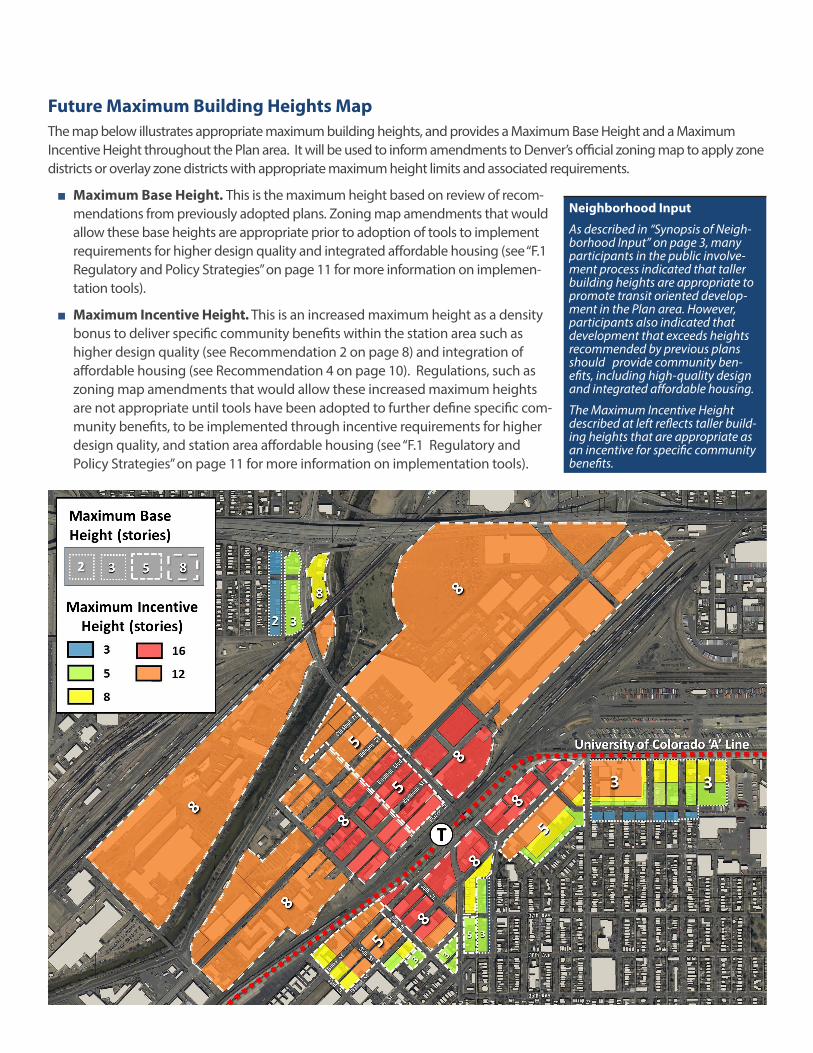
Future Maximum Building Heights MapThe map below illustrates appropriate maximum building heights, and provides a Maximum Base Height and a Maximum Incentive Height throughout the Plan area. It will be used to inform amendments to Denver’s official zoning map to apply zone districts or overlay zone districts with appropriate maximum height limits and associated requirements.
■ Maximum Base Height. This is the maximum height based on review of recom-mendations from previously adopted plans. Zoning map amendments that would allow these base heights are appropriate prior to adoption of tools to implement requirements for higher design quality and integrated affordable housing (see “F.1 Regulatory and Policy Strategies” on page 11 for more information on implemen-tation tools).
■ Maximum Incentive Height. This is an increased maximum height as a density bonus to deliver specific community benefits within the station area such as higher design quality (see Recommendation 2 on page 8) and integration of affordable housing (see Recommendation 4 on page 10). Regulations, such as zoning map amendments that would allow these increased maximum heights are not appropriate until tools have been adopted to further define specific com-munity benefits, to be implemented through incentive requirements for higher design quality, and station area affordable housing (see “F.1 Regulatory and Policy Strategies” on page 11 for more information on implementation tools).
Neighborhood Input
As described in “Synopsis of Neigh-borhood Input” on page 3, many participants in the public involve-ment process indicated that taller building heights are appropriate to promote transit oriented develop-ment in the Plan area. However, participants also indicated that development that exceeds heights recommended by previous plans should provide community ben-efits, including high-quality design and integrated affordable housing.
The Maximum Incentive Height described at left reflects taller build-ing heights that are appropriate as an incentive for specific community benefits.

38th & Blake Height Amendments8
2. ADOPT A NEW REGULATORY APPROACH TO ENSURE GREATER DESIGN QUALITY THROUGHOUT THE STATION AREA.
Intent: To provide new design regulations for improved design, to positively contribute to the adjacent public realm, and to achieve the following desired qualities:
▪ An active, walkable, and vibrant public realm
▪ Development sensitivity to daylight, views, and air
▪ Pedestrian-scaled details and entrances to address streets, prom-enades, and existing open spaces for neighborhood vibrancy
▪ Minimize the visual and physical impacts of parking
▪ Creation of quality pedestrian spaces such as pocket plazas, pedes-trian corridors, and other gathering spaces
▪ Provision of services and amenities for the community
▪ Integration of existing buildings into new development
■ Establish a comfortable pedestrian scale and reduce building massing for more daylight, views, and air for taller buildings while considering surrounding context. This transition may be accomplished through varia-tions in building-height, upper story setbacks, or other mass and scale alternatives.
■ Mitigate visual and physical impacts of parking and capitalize on the multitude of multi-modal public investments connecting the station area to the region. Explore opportunities, such as screening parking with ac-tive uses, no parking minimums, and other parking best practices where multi-modal choices are readily available.
RecommendationsNew Union Square Neighborhood building at 17th St. & Wewatta. Image Source: denver-cityscape.com

38th & Blake Height Amendments 9
3. ESTABLISH THE RIVER CORRIDOR AS AN AMENITY AND RE-SOURCE, WITH COMFORTABLE PEDESTRIAN SCALE AND EYES ON THE RIVER FOR SAFETY AND VIBRANCY.
Intent: To create an active riverfront experience while creating visual interest and variety, and allowing for sufficient light, views, and air along the river corridor.
■ Encourage design regulations that create variety and interest through varied building forms along the river, and design approaches to maxi-mize daylight and views to the river. Similar to Recommendation 2, this river edge treatment can be achieved through exploring a variety of design tools to implement this recommendation.
■ Require new development to front or address the South Platte Riverfront, just as primary streets and pedestrian corridors are required to be ad-dressed by new development with engaging pedestrian entrances and active ground uses.
■ With eyes on the promenade, evening lighting, and other well pro-grammed outdoor spaces, the promenade can be a vibrant place that encourages gathering while providing a sense of safety and security.
■ Encourage pedestrian-scaled elements between the public realm and adjoining development, pocket plazas or quality pedestrian-accessible outdoor / open spaces, upper story stepbacks, and a variety of heights and building forms.
Concept of future riverfront development fronting Arkins Court Promenade next to the South Platte River.
Riverfront development in Greenville, NC. Photo Source: hamptoninnandsuites-greenville.com
Depiction of riverfront development in Greenville, NC. Image Source: Cooper Carry

38th & Blake Height Amendments10
4. ADOPT A NEW REGULATORY APPROACH TO INTEGRATE AF-FORDABLE HOUSING AND MIXED INCOME DEVELOPMENT WITHIN THE 38TH AND BLAKE STATION AREA.
Intent: To encourage integration of affordability within the station area to generate more square footage and to locate more affordable housing units within walking distance of the 38th & Blake Station.
■ Provide a regulatory framework for integration of housing affordabil-ity within the station area by providing certain density incentives, or a density bonus to achieve the Maximum Incentive Height shown on the Future Maximum Building Heights Map.
■ Encourage partnership between City and private development to achieve goals related to affordable housing.
■ Coordinate with city-wide affordable housing funding efforts.
A Denver Housing Authority affordable housing building at 10th & Osage. Photo Source: Housingplusblog.com
The University of Colorado A Line opend in April 2016. Photo Source: Andy Cross / The Denver Post

38th & Blake Height Amendments 11
Moving ForwardREALIZING THE VISION
This Plan Amendment sets forth a refined vision for building heights within the 38th & Blake Station Area, and contains recommendations that define regulatory steps to achieve that vision. Plan implementation takes place over many years and is the result of large and small actions by the public sector and the private sector, sometimes in partnership. It’s understood that the future will bring unforeseen opportunities and challenges. The recommendations in this Plan Amendment are intended to provide direction for future actions en route to achiev-ing the refined vision for building heights.
TYPES OF IMPLEMENTATION ACTIVITIES
Blueprint Denver identifies three types of implementa-tion activities: regulatory/policy, public investment, and partnerships. These activities focus on public sector ac-tions, many of which create a positive environment that enables actions by other groups, such as property own-ers, developers, neighborhood organizations, districts or homeowners. While public actions can help set the stage, in most cases it is private action (such as constructing new buildings and houses, opening new businesses, and attracting new residents) that are the most critical ele-ments to achieving a plan’s vision.
F.1 REGULATORY AND POLICY STRATEGIES
Regulatory and policy strategies change City codes or regulations to affect desired outcomes. Typical examples include Denver Zoning Code text and map amendments, and Parks and Recreation requirements regarding open space and plantings.
Regulatory and Policy Implementation Priorities for the 38th & Blake Station Area:
■ Develop regulatory tools, such as a Design Overlay District, to implement recommendations for greater design quality througout the station area. Zoning map amendments that would allow the Maximum Incentive Height illustrated on the “Future Maxi-mum Building Heights Map” on page 7 are not appropriate prior to adoption of tools to implement requirements for higher design quality. See Recom-mendation 2 on page 8 for more information.
■ Regulatory tools to implement greater design qual-
ity should apply throughout the station area regard-less of underlying zone district.
■ Develop regulatory tools to require affordable hous-ing within the station area that utilize the increased Maximum Incentive Height illustrated on the “Future Maximum Building Heights Map” on page 7. Zoning map amendments that would allow the Maximum Incentive Height illustrated on the map are not appropriate until specific tools have been adopted to implement requirements for af-fordable housing. Note that the process to develop regulatory tools for affordable housing may result in tools that relate to future citywide requirements or do not apply to all projects in the Plan area. See Recommendation 4 on page 10 for more infor-mation.
■ Adopt zoning map amendments to rezone proper-ties within the 38th & Blake study area, consistent with the height and regulatory recommendations of this plan.
F.2 PUBLIC INVESTMENT STRATEGIES
Public Investment Strategies are those involving public funding of public infrastructure. Examples include public investment in street reconstruction, bike lane installation, new transit lines, park improvements, or new or expand-ed recreation centers. The City takes the lead in design-ing, constructing, and funding these projects and may use a variety of public funding sources such as the annual Capital Improvements Program, bond funds, or state or federal grant programs.
Public Investment Implementation Priorities for the 38th & Blake Station Area:
■ Continue to leverage public investments to imple-ment infrastructure, sidewalks, bike facilities, open space, and other multi-modal transportation recom-mendations from existing plans, in order to encour-age a less auto-dependent TOD community.
F.3 PARTNERSHIP STRATEGIES
Partnership Strategies represent the most diverse category of implementation activities. Public-private partnership (PPP or P3) activity has expanded greatly in recent years and has gone well beyond its roots of public subsidies of private development projects. Increasingly,

38th & Blake Height Amendments12
public-private partnerships are being used to fund infra-structure projects. Denver Union Station and RTD’s East and North Metro commuter rail lines are among the larg-est P3 projects in the country. Another local example is the reconstruction of 14th St. in Downtown Denver using a combination of City bond funds and a property-owner approved General Improvement District.
Partnership Implementation Priorities for the 38th & Blake Station Area:
■ Work with non-profit housing partners, Denver Of-fice of Economic Development, and other potential financing entities to create new affordable and mixed income housing units in the neighborhoods.
■ Work with registered neighborhood organizations, including the RiNo Art District to continue implemen-tation of recommendations from other plans, and to bring about positive impacts from new investment within the station area for surrounding neighbor-hoods.