2013 ebcnps comment for fema deis - east bay chapter
TRANSCRIPT
1
East Bay Chapter P O Box 5597, Elmwood Station. Berkeley, CA 94705
June 17, 2013
Federal Emergency Management Agency
Department of Homeland Security
500 C Street, SW
Washington, DC 20472
Subject: Draft HFRR EIS for the East Bay Hills, California
Dear Sir/Madam:
The California Native Plant Society’s East Bay Chapter appreciates the opportunity to
comment on the 2013 Hazardous Fire Risk Reduction Environmental Impact Statement
for the East Bay Hills of California.
The California Native Plant Society is a statewide non-profit organization that works to
protect California’s native plant heritage and preserve it for future generations. The
Society’s mission is to increase the understanding and appreciation of California's native
plants and to preserve them in their natural habitat. We promote native plant appreciation,
research, education, and conservation through our 5 statewide programs and 33 regional
chapters in California. The East Bay Chapter (EBCNPS) covers Alameda and Contra
Costa Counties and represents some 1100 members.
EBCNPS has been involved with protecting and conserving native plant resources in the
East Bay Hills for some 47 years. Our members have worked in these parks and preserves
in partnership with EBRPD and other entities over many decades. Our insights and
suggestions are derived from first hand experience.
This comment letter was coordinated by the Conservation Committee of EBCNPS, with
substantial contributions from our plant scientists on the Rare Plant, Vegetation, and
Significant and Unusual Plants Committees. Additionally, included in this letter are
comments written by chapter members who are local experts with special knowledge of
two of the regional preserves where fuels management work will occur.
These East Bay Hills are rich with native vegetation and rare and unusual plants that
often are found nowhere else in the two- county East Bay area. The East Bay Hills are
home to a large number of endangered, threatened, and locally rare plants, which could
be affected by fuels management projects. EBCNPS wants to ensure that the EIS will
address potential impacts to these plants, as well as to other more common, yet habitat
rich vegetation types. Appendix A provides a list of CEQA protected A-ranked plants, or
plants that are locally rare, including federally listed and state listed plants.
We understand FEMA's overarching charge in funding projects covered in the DEIS for
the East Bay Hills and the Richmond shoreline is to steward the public monies wisely by

2
funding work that will be effective in substantially reducing fire hazard, while protecting
to the greatest extent possible the natural resources and native habitat values of these
important wildlands.
FEMA has accepted the strategy of U.C. Berkeley and the City of Oakland to remove
whole populations of exotic trees and exotic shrubs and other invasive exotic weeds in
the native shrublands, while encouraging native plant communities to expand. Why then,
does this FEMA document allow the East Bay Regional Park District to potentially
perform actions that will have significant, irreversible and adverse impacts to native
habitats? These actions include radical thinning and clearing of extensive native
brushlands, scrublands, and riparian associations, while merely thinning, not removing
the highest fire hazard vegetation of all: the exotic acacia, pine and eucalyptus
plantations.
A key important element of the FEMA funding criteria is 'avoidance of impacts'. Yet the
Park District, which has a mission of protecting and enhancing native habitat values, is
the main entity in designing projects with serious impacts that will degrade native habitat
values by replacing viable stands of native vegetation with exotic annual grassland,
known for drying out the top layer of soil, and extending the fire season with dried out
flashy surface fuel that can act like a fuse to ignite other areas. Is this model of vegetation
management really going to produce a less hazardous condition in the East Bay Hills?
Will this approach break up stands of more fire-resistant, and firebrand-absorbing plant
communities, and replace them with hugely expanded acreages of more flammable exotic
weed monocultures? We certainly support efforts to remove broom and other weeds from
brush and scrublands. Does FEMA support the conversion of the biologically diverse and
richer native brush and scrublands to weedy exotic annual grasslands with little native
habitat value? Does FEMA support radical 'thinning' of shrub lands and converting 50-
70% of the biomass to weedy annual grassland as a good management strategy? Would
FEMA, in some cases where shrubland reduction is unavoidable, favor reducing the
amount of dead plant material by hand trimming, and allowing the native scrub to
regrow, in a younger and more lush iteration of that plant association (as noted in DEIS,
appendix M, page 13).
The FEMA grants require monitoring and weed maintenance for years to come. Yet the
FEMA grants do not supply funding for any of the follow up weed abatement. The East
Bay Regional Park District, City of Oakland, and UC Berkeley have great trouble
keeping up with acres of weedy species now in their stewardship purview. There just isn't
money available for comprehensive management of weedy invasives. This is
demonstrated by the many acres of weedy 'fuels managed' areas, including fire roads.
What mechanism is being instituted by FEMA in this DEIS to guarantee a commitment
of money and personnel for management of greatly increased acreages of newly created
annual weedy grassland?
Native perennial grasslands are altogether more fire resistant than exotic annual
grasslands, as the hardy native bunch grasses are deep rooted and hold moisture in their
above ground parts much longer than their weedy annual counterparts. Can FEMA in this

3
DEIS require that funds be made available long term, for conversion of native shrublands
into native perennial grasslands, where conversion to 'grassland' is deemed absolutely
necessary? Alternatively, where such a strategy is not considered feasible for brush,
scrub, and riparian associations, could FEMA in this DEIS, require hand thinning,
removal of invasive exotics, and removal of all nearby high fire hazard exotic tree
populations, as a more effective long term strategy?
This DEIS consistently lacks adequate vegetation naming, surveying and mapping,
related to the proposed and connected project areas. Why was the current Manual of
California Vegetation, Second Edition, not used in classifying the vegetation
communities accurately? This is an important oversight that renders much of the
document out of date and with questionable accuracy, regarding vegetation communities
that will be negatively impacted by proposed fuels management work. The M.O.U. that
established this requirement is appended to these comments.
In our EBCNPS letter prepared in response to the NOP for this DEIS on October 1, 2010
(Appendix B), we submitted a listing of Significant and Unusual Plants that we asked
adequate field surveys for, and mapping of these resources be prepared as part of the
resource assessment for this DEIS. Unusual and Significant Plants are those species that
in the local biotic and geographic region of this Project Limits clearly meet defined
standards for local rarity. These species should be considered in this DEIS; the concerned
Project Applicants are required by California environmental regulation to consider these
resources; projects potentially funded by FEMA should comply with local environmental
regulations. Further justification for FEMA to consider both Federally and State Listed
plants and plant communities together comes from the Memorandum of Understanding
For Cooperative Vegetation Habitat Mapping and Classification which was signed in
2000 (Appendix C) by multiple agencies responsible for resource oversight in California,
including both USFWS and CDFW.
Why has this document not included adequate survey and mapping data, assessments of
potential impacts, and mitigations for these impacts? Please find appended, an updated
listing of concerned species (Appendix A), as well as our original EBCNPS NOP
response letter mentioned above.
General Comments:
Throughout the document and maps botanical nomenclature and taxonomy are out of
date. This DEIS was released in 2013. The primary reference manual of the California
Flora is The Jepson Manual: Vascular Plants of California, Second Edition published in
January 2012. Therefore the DEIS should follow the accepted names used in California in
the preparation of this document. Updated names should be used in the Final EIS.
Will improper botanical names be revised before the final document?
Although mitigation measures are included for Phytophthora cinnamomi there are no
mitigation measures for Phytophthora ramorum (Sudden Oak Death). Sudden Oak Death
is known to occur in the East Bay hills and its spread should not be amplified through this

4
project’s activities. Mitigation measures for addressing this serious threat to the integrity
of our oak woodlands should include: surveys for the pathogen in project action areas,
how trees with Sudden Oak Death infections are treated during risk reduction activities,
and how tools are cleaned after Sudden Oak Death infected trees are cut.
New locations of individuals or small populations of pallid manzanita are most likely to
occur deep in the understory of Eucalyptus or Pine stands where they are in shaded
habitat. Because of their location in these understories, tree removal may result in sun
shock, which may kill these understory occupants by a rapid increase in sun exposure and
reduction in soil moisture. Trees in occupied pallid manzanita habitat should be removed
at the appropriate time to reduce potential sun shock to these plants. Project actions
should include the removal of the majority of the non-native and non-indigenous trees in
the fall. The timing of the tree removal in late fall will allow existing pallid manzanitas to
adjust to the increased exposure to light and heat during cooler seasonal temperatures
before the following spring and summer.
CDFG protocols state: “A discussion of threats, including those from invasive species, to
the plants and natural communities” must be included as part of the assessment of
potential impacts in a project environmental document. This DEIS does not include a
discussion of threats particular weed species may pose to existing populations of rare
plants species and/or sensitive natural communities within project action areas. Without
detailed information about the types of invasive weeds and the chemicals that may be
used to treat them, an evaluation of real threats to rare plants and/or sensitive natural
communities from weed species or herbicide application cannot be made. This document
should include a detailed discussion of what weed/invasive species are of concern on site
and what measures will be taken to protect rare plants and/or sensitive natural
communities before, during, and after project related activities.
Specific Comments (Wording from dEIS document in italics):
Use of MCV2
Section 4.2.2.1.3 Vegetation Mapping Classification was conducted in general
accordance with the California Native Plant Society (CNPS)’ A Manual of California
Vegetation (Sawyer et al. 2008).
Comments:
The document says that MCV2 (referenced as Sawyer et al. 2008) was used to
type the vegetation but the figures do not present MCV2 types. Why not?
We assume the CNPS/CDFG vegetation mapping/sampling methods (20111) were
used in order to type the vegetation based on MCV2. If so, how many relevé or
1 California Native Plant Society/Department of Fish and Game. 2011. Protocol for Combined Vegetation
Rapid Assessment and Relevé Sampling Field Form. May 2011.
http://www.cnps.org/cnps/vegetation/pdf/protocol-combined.pdf [Accessed June 13, 2013]
5
rapid assessment plots were used to characterize and classify the vegetation types
within the project area? Can these data forms be appended to this document?
Were the ‘existing vegetation conditions’ referenced on page 4.2-4 (including
EBRPD EIR data [EBRPD 2010] and potentially FEMA 2006a, FEMA 2006b,
and EBRPD 2006) collected to MCV2 vegetation types? If not, then the data
needs to be cross-walked to MCV2 in order properly assess impacts to sensitive
natural community types.
Results presenting MCV2 types should be presented in a recirculated DEIS so the
significance of any impacts to sensitive natural communities due to project
activities can be evaluated and commented on by the public. This data should
either (1) be presented as an appendix to the DEIS and provided with a cross-walk
between the broader community types presented in the figures and each MCV2
type or (2) the vegetation community descriptions should be written as MCV2
types, at least to the Alliance level.
------------------------------------------------------------------------------------------------------------
Sections Dealing With Sensitive Natural Communities
Section 4.2.3.1.1 Pages 4.2-25 and 4.2-26. Database searches were conducted using the
boundaries defined by the following USGS 7.5-minute quadrangles that overlap the
proposed and connected project areas, hereafter known as “project quadrangles”: San
Quentin, Richmond, Oakland West, Oakland East, Briones Valley, Las Trampas Ridge,
San Leandro, and Hayward,
Page 4.2-5 Table 4.2-2 lists the CDFW status of five locally distinct vegetation
communities and their potential to occur in the proposed and connected project areas
based on the California Natural Diversity Database (CNDDB 2012) and field surveys.
Northern maritime chaparral is the only locally distinct vegetation community present in
the project areas.
Comments:
According to CDFW guidelines (2009)2, the database search for special-status
plants and natural communities should include the quadrangles that the project is
located on plus the adjacent quadrangles. This search would result in adding
Coastal Brackish Marsh for consideration of the potential to occur in the proposed
and connected project areas. This should be added to a recirculated DEIS.
Sensitive natural communities are notoriously underreported. In addition, the data
in CNDDB is only for Holland vegetation types; data for vegetation stands typed
with MCV2 has not been entered into the system yet (the only MCV2 types that
have been entered into CNDDB are those mapped under VegCAMP
[approximately 1/3 of the State of California, but not yet including the San
Francisco Bay Area] [Diana Hickson, CDFW, pers. comm. with East Bay CNPS
2013]). Consequently, some sensitive natural communities are much more
2 Protocols for Surveying and Evaluating Impacts to Special Status Native Plant Populations and Natural
Communities. November 2009. https://nrm.dfg.ca.gov/FileHandler.ashx?DocumentID=18959&inline=1
[Accessed June 13, 2013]

6
prevalent in the proposed and connected project areas than is reflected in this
document.
The DEIS does not attempt to translate between the Holland types that were
queried and MCV2 types which is the current standard. This results in some
confusion of naming standards. For instance, Northern Maritime Chaparral is an
outdated reference to what is Brittle leaf-Wooly leaf manazanita chaparral within
the proposed and connected project areas; this alliance is more equivalent to
Central Maritime Chaparral.
Another reason for presenting the MCV2 types is that the list of mapped
vegetation alliances should be checked against the most recent CDFW List of
Vegetation Alliances and Associations (20133) to determine if any of the types are
considered sensitive natural communities (i.e., sensitive or special-status natural
communities are vegetation types that have been identified on the most recent
CDFW List of Vegetation Alliances and Associations as being critically imperiled
[state ranking of S1], imperiled [S2], or vulnerable [S3]).
Page 4.2-6, Table 4.2-2 Northern maritime chaparral: Present. There are two CNDDB
occurrences present in the proposed and connected project areas at Sobrante Ridge and
Huckleberry Botanic Regional Preserves.
Section 3.4.2.3.1 Sobrante Ridge Regional Preserve. Sobrante Ridge Regional Preserve
contains proposed project area SO001, a 4.1-acre area on the western edge of the
preserve, opposite the eastern end of Rain Cloud Drive. The dominant type of vegetation
is oak-bay woodland. EBRPD would convert 0.56 acres of northern maritime chaparral
to successional grassland to enhance growing conditions for pallid Manzanita, a
federally designated threatened species (see Section 4.2.3). The oak-bay woodland would
be preserved.
Comments:
Maritime chaparral is a particularly important community type as it is considered
to be among the rarest of the remnant plant communities found in the East Bay
hills (Dr. Keeler-Wolf, co-author of MCV2 and Senior Vegetation Ecologist with
VegCAMP in the Biogeographic Data Branch of CDFW, pers. comm. with
EBCNPS 2013; also see Vasey et al. 20124). It is not only present at Sobrante
Ridge and Huckleberry Botanic Regional Preserves but also in other areas within
or adjacent to the proposed and connected project areas including within
Knowland Park, near Canyon, near Briones Reservoir, Leona Heights (west,
southwest, and south of Merritt College), and in the hills surrounding Upper San
Leandro Reservoir (location data provided by Dr. Keeler-Wolf, CDFW, pers.
comm. with EBCNPS 2013).
3 CDFW 2013. Natural Communities --Background Information. California Department of Fish and Game,
Sacramento, California. http://www.dfg.ca.gov/biogeodata/vegcamp/natural_comm_background.asp
[Accessed June 13, 2013] 4 Vasey, M.C., M.E. Loik, and V.T. Parker. 2012. Influence of summer marine fog and low cloud stratus on
water relations of evergreen woody shrubs (Arctostaphylos: Ericaceae) in the chaparral of central
California. Oecologia. October 2012. Volume 170, Issue 2, pp 325-337.
7
There is a regulatory model for how to address potential impacts to rare maritime
chaparral found within the California Coastal Commission (CCC):
The CCC requires protection of maritime chaparral as an Environmentally
Sensitive Habitat Area (ESHA) under Section 30240 of the Coastal Act.
An ESHA is described as “Any area in which plant or animal life or their
habitats are either rare or especially valuable because of their special
nature or role in an ecosystem and which could be easily disturbed or
degraded by human activities and developments.” Protection of ESHAs is
achieved by avoidance of impact: forbidding any development, including
roads and structures, within the ESHA and within a buffer zone of 50-100
feet from any development (John Dixon, California Coastal Commission,
pers.comm. with EBCNPS 2013). Depending upon individual
circumstances, the CCC may also calculate any previous loss of chaparral
habitat at a project site due to roads or other development and can require
that these areas be counted in the total impacts. It can also require
restoration where appropriate because of previous "taking". Staff
biologists undertake extensive reviews of every development proposal,
and decisions whether and what to permit are based on a firm
understanding of the ecology of the ESHA.
The statement in Section 3.4.2.3.1 that “EBRPD would convert 0.56 acres of
northern maritime chaparral to successional grassland to enhance growing
conditions for pallid Manzanita…” is nonsensical. Pallid Manzanita is a maritime
chaparral species, not a grassland species. Converting maritime chaparral acreage
to grassland will harm growing conditions for pallid Manzanita rather than
“enhance” them.
The proposed fuels treatment of shrublands and scrublands (removal of 50-70%
shrub cover or the conversion of shrublands to annual grasslands5) must be
avoided in any sensitive natural community, including within maritime chaparral.
Page 4.2-6, Table 4.2-2 Valley Needlegrass Grassland: No potential. The community is
not present in the proposed and connected project areas. There were no observations of
the community during field surveys, and there are no CNDDB occurrences in the
proposed and connected project areas.
Page 4.2-5 Small patches of two other sensitive vegetation communities, serpentine
bunchgrass and coastal terrace prairie, also occur as described below.
Page 4.2-18 and 19 In the Miller/Knox Regional Shoreline area, native grasses in
coastal prairie patches include seashore bentgrass (Agrostis pallens) junegrass (Koeleria
macrantha), and red fescue (Festuca rubra). These areas of coastal prairie were not
mapped because the patch sizes were much smaller than the minimum mapping area
identified in the methods of this project.
5 Biological Opinion for the Proposed Federal Emergency Management Agency (FEMA) Hazardous Fire Risk
Reduction Project in the East Bay Hills of Alameda and Contra Costa Counties, California (HMGP 1731-16-34, PDM-
PJ-09-CA-2005-003, PDM-PJ-09-CA-2005-11, and PDM-PJ-09-CA-2006-004). May 10, 2013. p 16.
8
Page 4.2-21 Scattered native grasses, including purple needlegrass, blue wild rye, and
creeping wild rye (Leymus triticoides), occur sparingly in this community in the proposed
and connected project areas.
Comments:
Areas of Purple Needlegrass (Stipa pulchra, formerly Nassella pulchra)
Grassland, Valley Needlegrass Grassland, and Creeping Wildrye (Elymus
triticoides, formerly Leymus triticoides), all considered sensitive natural
communities, are present within the project area. Stating that these grasses occur
sparingly is not enough information to indicate the cover values of these species
within affected grasslands. Cover values determine if these patches qualify as
distinct communities based on the membership rules for the subject community.
Depending on the type, cover values can be as low as 20% for Purple Needlegrass
Grassland. If the minimum mapping unit was 200 square feet (as described on
page 4.2-4), there would certainly be some areas qualifying as these grassland
types. Why were these areas not evaluated based on cover values, mapped, and
included for impact analysis with this document? They should be included. In
addition, numerous stands of purple needlegrass and creeping wildrye have been
documented in other areas within or adjacent to the proposed and connected
project areas including in the hills between Canyon and the southern edge of
Upper San Leandro Reservoir (location data provided by Dr. Keeler-Wolf,
CDFW, pers. comm. with EBCNPS 2013). These sensitive natural communities
should be mapped and included for impact analyses.
Coastal terrace prairie is not only present at Miller/Knox Regional Shoreline, but
also in other areas within or adjacent to the proposed and connected project areas
including Point Molate and Point Richmond. This sensitive natural community
should be mapped and included for impact analyses.
Other sensitive natural communities which exist in the proposed and connected
project areas include Bay Woodland (which should be separated from Live Oak
Woodland, particularly within the drainages) and Redwood forests. Need to
ensure impacts to all potential sensitive natural communities are avoided.
------------------------------------------------------------------------------------------------------------
4.2.3.1 Methodology for Evaluating the Presence of Sensitive Biological
Resources. The evaluation of the sensitive biological resources in the proposed and
connected project areas consisted of database searches, a literature review, and field
surveys of vegetation communities.
Comment:
This section does not include an evaluation of locally rare plant species. CEQA
requires that impacts to “resources that are rare or unique to that region” be
evaluated [CEQA Guidelines 15125(c)]. This includes botanical resources that
are, but not limited to, peripheral populations and disjunct subpopulations. These
are informal terms that refer to those species that might be declining or be in need
of concentrated conservation actions to prevent decline, but have no legal
9
protection of their own. Also, CEQA Guidelines Section 15380 states “a species
not included in any listing…shall nevertheless be considered to be rare or
Endangered if the species is likely to become Endangered within the foreseeable
future throughout all or a significant portion of its range and may be considered
Threatened as that term is used in the Endangered Species Act.” Locally rare
species tracked by the East Bay Chapter of CNPS meet these criteria (Lake
20106). Their status is based on their rarity and endangerment throughout all or
portions of their range. Since the concerned Project Applicants are required by
California environmental regulation to consider these resources; projects
potentially funded by FEMA should comply with local environmental regulations.
------------------------------------------------------------------------------------------------------------
Table 4.2-3
Comment:
The following comments address the inadequacy of determinations for potentially
occurring rare plant species within the project areas.
Choris' popcorn-flower (Plagiobothrys chorisianus var. chorisianus) = This
species was determined as having no potential to occur within project areas.
Based on specimen information included in the California Consortium of
Herbaria7 there are known records of this species from "Strawberry Canyon,
Berkeley Hills" and Oakland". The potential to occur should be changed from
"No Potential" to "Low Potential".
Coastal triquetrella (Triquetrella californica) = based on information from our
Rare Plant Committee Chairman, this species' potential to occur should be
changed from "No Potential" to "Moderate Potential". This is an often overlooked
species that has been observed in new locations throughout the Bay Area in
habitat resembling "successional grasslands" as described in this document. With
little to no moss inventorying taking place in the East Bay it cannot be ruled out
as not occurring within the project areas as there are historic records from Mount
Diablo and new records from San Bruno Mountain (pers. comm. Bartosh 2013).
Because there is abundant suitable habitat between these two localities this
species should be considered as having a potential to occur within the project
areas.
Coast Iris (Iris longipetala) = This species was not addressed in the table. It
should be treated as having a "Moderate Potential" to occur within the project
areas based on herbaria records from the "top of the North Berkeley Hills" and
"Point Isabel" (CCH 2013)
6 Lake, Dianne. 2010. Rare, Unusual and Significant Plants of Alameda and Contra Costa Counties. East Bay Chapter
of the Caliornia Native Plant Society. 7 Data provided by the participants of the Consortium of California Herbaria (CCH) (ucjeps.berkeley.edu/consortium/).
10
Fragrant fritillary (Fritillaria liliacea) = The location Miller Knox should be
added to the areas where this species has the potential to occur based on a
collection from "Point Richmond" (CCH).
Kellogg's horkelia (Horkelia cuneata var. sericea) = Herbaria records do exist for
this species from the "Oakland" area (CCH 2013) and suitable habitat is present
within the project areas, therefore the potential for occurrence of this species
should be changed from "No potential" to "Low Potential".
Mount Diablo cottonweed (Micropus amphibolus) = This species is not addressed
in the table though it should be based on numerous records appearing in the
Consortium of California Herbaria from localities such as "Old Tunnel Road",
"Strawberry Canyon", "North Berkeley Hills", and "Wildcat Canyon". This
species should be treated as having a "High Potential" to occur within the project
areas.
Oakland Star-tulip (Calochortus umbellatus) = This species is not addressed in
the table though it should be based on numerous records appearing in the
Consortium of California Herbaria from localities such as "Grizzly Peak", "above
Mills College", "East Oakland Hills", "Strawberry Canyon", "Wildcat Canyon",
and near "Lake Temescal". This species should be treated as having a "High
Potential" to occur within the project areas.
Bristly leptosiphon (Leptosiphon acicularis) = This species was not addressed in
the table. It should be treated as having a "Moderate Potential" to occur within the
project areas based recent CNDDB records from the Oakland Hills and the fact
that this species is often overlooked and underreported (pers. comm. Bartosh
2013).
San Francisco Bay sunflower (Chorizanthe cuspidata var. cuspidata) = The
infraspecific name for this taxon is misspelled in the table.
Pallid manzanita (Arctostaphylos pallida) = It should be noted that this species
can also occur as isolated individuals or small groups in the understory of
Eucalyptus forest in the East Bay Hill as this species has been observed in low
numbers within this habitat type in Redwood Regional Park. Rare plant surveys
should focus on identifying and locating these individuals or small populations
within this habitat type (pers. comm. Bartosh 2013).
------------------------------------------------------------------------------------------------------------
5.1.6.3.2 Proposed and Connected Actions
Impacts during Implementation
This subsection states that special-status plant species “could be directly impacted if they
are present in treatment, staging, or access areas during implementation. Plants could be
damaged or killed by workers or heavy machinery or indirectly impacted from loss of
suitable habitat conditions.”
Comment:
The purpose of an Environmental Impact Statement is to evaluate impacts on the
environment, in this case special-status species, from a proposed action. Since

11
there have been no protocol-level rare plant surveys conducted in proposed action
areas to date, the actual presence and distribution of special-status plant species
and the affects of proposed project actions were not evaluated in this document.
Without abundance and distribution information the potential significance of
impacts to special-status plant species is inadequately evaluated in this document.
Real impacts to rare plant species should be evaluated herein which can only take
place after protocol-level rare plant surveys have been conducted, level of impacts
based on proposed actions are evaluated, and this DEIS is recirculated with that
information.
Impacts from Habitat Loss or Alteration
Temporary loss or alteration of habitat could result in impacts on special-status plants
due to erosion or changes in soils from the placement of eucalyptus wood chips. During
implementation of the proposed and connected actions, the best management practices
described in Section 5.1.3.3.1 would be implemented to avoid potential impacts from soil
erosion. In addition, MMPs would be implemented to restore and enhance native habitats
in the long-term. An analysis of the potential for toxicity from eucalyptus wood chips
indicates that short-term and localized effects on soil microbes, soil invertebrates, and
terrestrial plant seedlings may result from exposure to fresh eucalyptus and possibly pine
wood chips (see Appendix L).
Comment:
This evaluation and conclusive assumption that the effects of Eucalyptus and Pine
wood chips are negligible on special-status plant species and their habitat is
inadequate. This is based on a study produced out of Florida and assumes that
allelopathic effects from Eucalyptus and Pine species last only three months.
There is no data presented in this document, including Appendix L, on what
species of Eucalyptus or Pine were studied. Are these the same species we have in
California? This section also does not evaluate the potential affects of wood chip
spreading to special-status plant species with differing life forms such as
geophytes (bulbs), annuals, herbaceous perennials, and shrubs. Wood chips affect
bulbs and herbaceous species in different ways than woody shrubs. An evaluation
and action of how wood chip application is executed within occupied rare plant
habitat based on life form should be included in this document.
Impacts From Herbicide Application
The application of herbicides could result in impacts on special-status plants if there is
direct contact with chemicals that cause toxicity. Herbicide application is unlikely to
affect pallid manzanita or Presidio clarkia because these species are not known to be
present in the treatment areas proposed for herbicide application. However, if pallid
manzanita, Presidio clarkia, or other special-status plants are present, they could be
affected. Mitigation measures described in Section 5.1.6.3.3 would be taken to protect
any special-status plants that could be present unexpectedly in or near the treatment
areas.
Comment:

12
This mitigation measure as well as mitigation measure 5.1.6.3.3 are inadequate as
they do not address or mitigate herbicide application near occupied habitat for
special-status plant species other than Presido Clarkia and Pallid Manzanita. This
mitigation measure should address the timing and type of herbicide used based on
the type of habitat and life form (annual, perennial, or shrub) of the subject rare
plant.
------------------------------------------------------------------------------------------------------------
5.1.6.3.3 Mitigation Measures
Protocol Surveys (BR-8)
As described in Section 5.1.6.2.3, a biological monitor would be made available to be on
site and/or on call during implementation activities to avoid or reduce potential impacts
on special status species under the proposed and connected actions such that impacts
would not be significant. In addition, the following measure specific to special-status
plants would be implemented:
Pre-implementation surveys would be conducted to determine the presence of
special-status plants within the project areas where vegetation management
activities would be conducted. Botanists would conduct a botanical survey for the
listed species during the blooming period for each species before vegetation
management activities start. All special-status plants would be clearly flagged
with high visibility flagging and avoided.
Comment:
Conducting surveys to locate special-status plant species after the release of this
DEIS does not provide full disclosure of all rare plant species present within the
project areas and allow for a full analysis of the significance of impacts resulting
from this project. This mitigation measure is inappropriate to determine the
significance of impacts to existing special-status plant populations or those yet
unknown because of the lack of an evaluation of direct, indirect, and cumulative
impacts to specific plant taxa throughout their overall range and within the region.
This is also deferred mitigation. California Department of Fish and Game (CDFG)
rare plant survey protocols8 “meet California Environmental Quality Act (CEQA)
requirements for adequate disclosure of potential impacts”. These protocols
indicate that Botanical Survey Reports should include the following to assess
potential impacts:
A discussion of the significance of special status plant populations in the project
area considering nearby populations and total species distribution;
A discussion of the significance of special status natural communities in the
project area considering nearby occurrences and natural community distribution;
A discussion of direct, indirect, and cumulative impacts to the plants and natural
communities;
8 Protocols for Surveying and Evaluating Impacts to Special Status Native Plant Populations and Natural
Communities. November 2009. https://nrm.dfg.ca.gov/FileHandler.ashx?DocumentID=18959&inline=1
13
A discussion of threats, including those from invasive species, to the plants and
natural communities;
While details of this information is provided for Pallid manzanita and Presidio
clarkia, no information of this nature (bulleted items) is provided for any of the
other rare plant species known to occur within or adjacent to project action areas.
Rare plant surveys should be conducted and their results included in a recirculated
DEIS so the significance of any impacts to rare plants due to project activities can
be evaluated and commented on by the public.
------------------------------------------------------------------------------------------------------------
Specific Comments Regarding EBRPD Sobrante Ridge Treatment from EBCNPS
member Gudrun Kleist
I live within easy walking distance of Sobrante Ridge and have been hiking there daily
since March 1987. While there are plenty of non-natives such as annual grasses, yellow
star thistle, poison hemlock and others, there are essentially no non-native trees nor
shrubs (including broom) growing on Sobrante Ridge (yet).
It appears from reading 81420-2010-F-0849-3 that the park service intends to convert the
oak/bay forest at the West side to oak woodland and “California” annual grasslands,
which are essentially non-native weed farms. There is no detailed close-up map of the
exact area, so it is difficult to determine just where this work is to be done.
I find the section on the Alameda manzanita (Arctostaphylos pallida) particularly
troubling, especially the removal of Madrone (Arbutus menziesii) and the other
Manzanitas growing in the area. There are only a handful of Madrones growing in a very
small area, one of them a majestic old tree. To cut down a mature hundred(s) year old
native tree to “save” a couple of Manzanitas is absurd. The different Manzanitas and the
Madrones bloom in succession over many months starting in December through April
providing food for the native hummingbirds and bumblebees. The berries from all are
consumed by birds and small mammals. (Rodents are an important food source for the
Alameda whip snake). While I agree that the California Bay trees (Umbellularia
californica) should be removed, decimating or damaging a sensitive vegetation
community while considering the preservation of only one species in it is
counterproductive. The same is true for only taking the Alameda whip snake and red-
legged frog into consideration instead of all of the native fauna that are interrelated.
Ironically, one of the major reasons for the decline of A. pallida is fire suppression. A.
pallida seeds need fire to germinate. The occasional fire in a Northern Maritime
Chaparral also keeps undesirable (native) plants such as Umbellularia californica at bay
(pun intended).
On Sobrante Ridge, many years of herbicide spraying and running large herds of goats
unsupervised by a plant knowledgeable person to control the “California” annual
14
grasslands have resulted in a decline of the few native species and an invasion of even
bigger weeds. Oaks have been gouged and their trunks buried in dirt by bulldozers
“clearing” the fire roads. The chips of cut and pruned trees are blown into the woods,
covering the understory and piling up against tree trunks.
All this leaves me with wondering how well the extremely valuable and rare park
resources will be managed in regards to native flora and fauna, especially with this new
vegetation management work to be done.
-Gudrun Kleist
------------------------------------------------------------------------------------------------------------
Specific Comments from EBCNPS Restoration Committee Chair, Janet Gawthrop
Regarding EBRPD Huckleberry RP and Sibley RP Treatment
Unlike much other public land in the East Bay Regional Park District (EBRP), both
Huckleberry and Sibley are regional preserves, not just parks. Both received the preserve
designation because of their unusual natural resources, botanical as to Huckleberry, and
mostly geological, with some botanical in Sibley.
Huckleberry and Sibley preserves share a boundary, as well as much indigenous flora.
Much of this flora is unusual in the East Bay, not just pallid manzanita. Western
leatherwood occurs in many locations in Huckleberry, but the US Fish & Wildlife
Service (USFWS) discusses preservation measures for western leatherwood only in
Redwood Regional Park. Along with this oversight, both the FEMA EIS and USFWS
Biological Opinion omit all reference of the many rare taxa, including the population of
locally rare shrub (Vaccinium ovatum) for which Huckleberry Botanic Preserve was
named. While EBRP's goal of removing invasive plants is laudable, the district would
only detract from its stated goal of fire prevention by disturbing the native plant
communities that have been growing there.
FEMA should not grant funding to remove or thin "shrubland" vegetation in either of
these preserves until EBRP conducts biological surveys of the preserves, using current
protocols in the Manual of California Vegetation, 2nd
edition (MCV2). "Shrubland",
without more, does not designate a fire risk or a plant community. The FEMA EIS
presents inadequate description of the preserves' flora to allow any contractor bidding on
the work to save the flora that originally inspired creation of Huckleberry Botanic
Preserve.
Both Huckleberry and Sibley preserves now have healthy stands of rare maritime
chaparral, in which federally listed pallid manzanita grows. Disturbance and thinning of
maritime chaparral communities will almost certainly open the way for invasive plants to
establish themselves where the present, native vegetation now largely excludes them.
Rather than "shrubland islands" or thinning, eradication of the Eucalyptus globulus grove
next to the parking lot, with hand felling of individual Monterey pines in the preserve,

15
will eliminate what little fire risk now exists in Huckleberry Botanic Preserve.
The maps and polygons included in the FEMA EIS lack sufficient detail even to
distinguish the labyrinthine boundary of Huckleberry with various private property
owners uphill of the park. It is possible to see PG&E towers in the EIS aerial photos, but
impossible to find the low, yellow lane of dead exotic grasses seen easily at ground level.
All the coastal scrub and maritime chaparral plants in surrounding parkland retain their
moisture and remain green as ever into the summer. The exotic, annual grassland that
grew in after PG&E "tree work" below their tower presents the most flammable
vegetation in the area. The chapter's monthly restoration crew at Huckleberry has not
found any perennial bunchgrasses in the PG&E clearance area, even though native,
perennial bunchgrasses now grow only a few meters away in undisturbed areas.
EBCNPS is concerned that in the vegetation management goals9 for the Huckleberry
RTA's none of them mention the maritime chaparral as a management goal. The maritime
chaparral is mentioned to exist there in the description of the RTA, but not as a
vegetation management goal. Palid Manzanita is of course a plant worthy of protection,
but it is important not to overlook its native habitat (maritime chaparral) when
considering how to best preserve the species.
-Janet Gawthrop
Restoration Committee Chair, EBCNPS
------------------------------------------------------------------------------------------------------------
EBCNPS appreciates the consideration of these comments and will look forward to
following this project in the future. Please do not hesitate to contact us with questions at
[email protected] or by phone at (510) 734 0335.
Sincerely,
Jean Robertson
Chair, Conservation Committee
East Bay Chapter,
California Native Plant Society
9 Biological Opinion for the Proposed Federal Emergency Management Agency (FEMA) Hazardous Fire Risk
Reduction Project in the East Bay Hills of Alameda and Contra Costa Counties, California (HMGP 1731-16-34, PDM-
PJ-09-CA-2005-003, PDM-PJ-09-CA-2005-11, and PDM-PJ-09-CA-2006-004). May 10, 2013. pp 29-30.

16
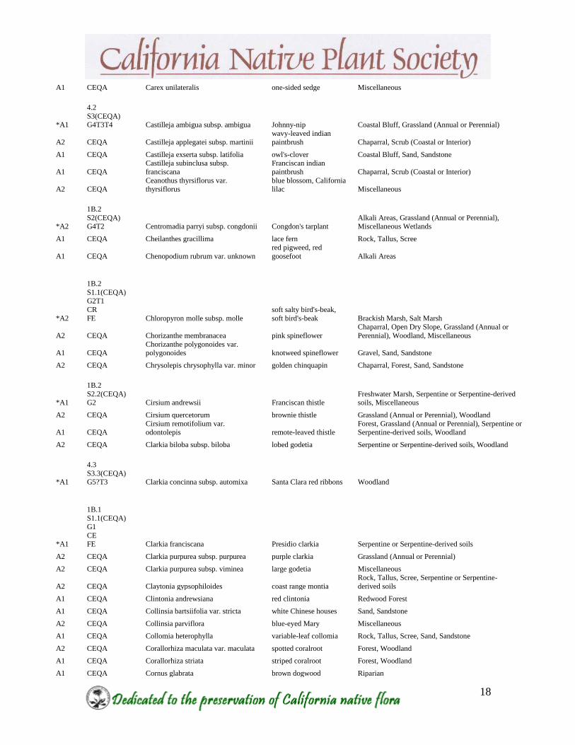
APPENDIX A: CEQA protected A-Ranked Plants known from the East Bay Hills - 2013
East
Bay
CNPS
Rarity
Rank
California
Rarity Rank
Scientific
Name Common Name Habitat
A1x CEQA Acmispon denticulatus meadow trefoil Riparian, Miscellaneous
A1x CEQA Acmispon junceus var. biolettii rush lotus Chaparral, Sand, Sandstone
A2 CEQA Adiantum aleuticum five-finger fern Riparian
A1 CEQA Agoseris apargioides var. apargioides seaside agoseris
Forest, Grassland (Annual or Perennial), Scrub
(Coastal or Interior), Sand, Sandstone
A1 CEQA Agoseris apargioides var. unknown seaside agoseris Miscellaneous
A2 CEQA Agrostis hallii Hall's bent grass Forest, Woodland
A2 CEQA Allium amplectens narrow-leaved onion
Open Dry Slope, Serpentine or Serpentine-derived
soils,
Woodland, Miscellaneous
A1 CEQA Allium falcifolium sickle-leaved onion
Rock, Tallus, Scree, Serpentine or Serpentine-derived
soils
A2 CEQA Alnus rubra red alder Riparian
A2 CEQA Amaranthus californicus Californian amaranth Miscellaneous Wetlands
A2 CEQA Amaranthus powellii Powell's amaranth Miscellaneous
A1 CEQA Ammannia coccinea long-leaved ammannia Riparian, Miscellaneous Wetlands
*A1x
4.2 S3.2(CEQA)
G3 Amsinckia douglasiana Douglas' fiddleneck Open Dry Slope, Rock, Tallus, Scree
A2 CEQA Amsinckia eastwoodiae Eastwood's fiddleneck Grassland (Annual or Perennial), Miscellaneous
*A2
1B.2 S2(CEQA)
G2? Amsinckia lunaris
bent-flowered
fiddleneck
Grassland (Annual or Perennial), Woodland,
Miscellaneous
A2 CEQA Amsinckia tessellata var. tessellata desert fiddleneck, devil's lettuce Grassland (Annual or Perennial), Miscellaneous
A1 CEQA Anagallis minima chaffweed Vernal Pool, Miscellaneous Wetlands
*A2
4.2
S3.2?(CEQA) G5?T3T4 Androsace elongata subsp. acuta California androsace Open Dry Slope, Grassland (Annual or Perennial)
A2 CEQA Anisocarpus madioides
woodland tarweed,
woodland madia Forest, Redwood Forest, Woodland
A1x CEQA Anthoxanthum occidentale
California sweet grass,
vanilla grass Forest, Redwood Forest
A2 CEQA Apocynum cannabinum dogbane, Indian-hemp Freshwater Marsh, Riparian
A1x CEQA Arctostaphylos crustacea subsp. rosei Rose's manzanita Chaparral, Sand, Sandstone
*A1
1B.1
S1(CEQA)
G1 CE
FT Arctostaphylos pallida pallid manzanita Chaparral, Sand, Sandstone
A2 CEQA Asarum caudatum wild-ginger Forest, Redwood Forest
A1 CEQA Asclepias cordifolia purple milkweed Chaparral, Grassland (Annual or Perennial), Rock, Tallus, Scree, Woodland
A2 CEQA Asclepias speciosa
showy milkweed,
milkweed Miscellaneous

17
*A1
1B.2
S2(CEQA) G2T2 Astragalus tener var. tener alkali milkvetch
Alkali Areas, Grassland (Annual or Perennial), Vernal Pool, Miscellaneous Wetlands
*A2
1B.2
S2(CEQA) G2 Atriplex joaquinana
San Joaquin spearscale, San Joaquin saltbush
Alkali Areas, Grassland (Annual or Perennial), Miscellaneous Wetlands
A2 CEQA Atriplex lentiformis big saltbush Alkali Areas, Scrub (Coastal or Interior)
*A1
1B.2
S2(CEQA) G3G4T2 Balsamorhiza macrolepis big-scale balsamroot
Grassland (Annual or Perennial), Serpentine or Serpentine-derived soils
A1 CEQA Berberis nervosa Oregon grape Forest
A2 CEQA Brodiaea terrestris subsp. terrestris dwarf brodiaea
Grassland (Annual or Perennial), Woodland,
Miscellaneous Wetlands
A1? CEQA Calamagrostis koelerioides tufted pine grass
Open Dry Slope, Grassland (Annual or Perennial),
Miscellaneous
A1x CEQA Calamagrostis nutkaensis Pacific reed grass Coastal Strand, Freshwater Marsh, Forest, Redwood Forest
*A2
4.2
S3.2?(CEQA) G4 Calandrinia breweri Brewer's calandrinia Burns, Chaparral, Scrub (Coastal or Interior)
*A2
1B.1
S2(CEQA) G2 California macrophylla round-leaved filaree
Grassland (Annual or Perennial), Scrub (Coastal or Interior)
*A2
1B.2
S2.1(CEQA) G2 Calochortus pulchellus
Mount Diablo fairy-lantern
Chaparral, Serpentine or Serpentine-derived soils, Woodland
*A2
4.2
S3.2(CEQA) G3 Calochortus umbellatus Oakland star-tulip Chaparral, Scrub (Coastal or Interior), Woodland
A1 CEQA Calycadenia multiglandulosa sticky calycadenia
Rock, Tallus, Scree, Scrub (Coastal or Interior),
Serpentine or Serpentine-derived soils
A2 CEQA
Calystegia malacophylla subsp.
pedicellata woolly morning-glory
Chaparral, Serpentine or Serpentine-derived soils,
Scrub (Coastal or Interior)
A2 CEQA Calystegia sepium subsp. limnophila hedge bindweed Miscellaneous Wetlands
A2 CEQA Camissoniopsis intermedia small primrose Burns, Scrub (Coastal or Interior)
A2 CEQA Camissoniopsis micrantha small primrose Coastal Strand, Dry Wash, Sand, Sandstone
A1 CEQA Carex aquatilis var. dives Sitka sedge Miscellaneous Wetlands
A1 CEQA Carex brevicaulis short-stemmed sedge Rock, Tallus, Scree, Sand, Sandstone
A2 CEQA Carex densa dense sedge Miscellaneous, Miscellaneous Wetlands
A1 CEQA Carex globosa round-fruited sedge Miscellaneous
A1x CEQA Carex gracilior slender sedge
Forest, Grassland (Annual or Perennial),
Miscellaneous
Wetlands, Miscellaneous
A1 CEQA Carex harfordii
Harford's sedge,
Monterey sedge Miscellaneous Wetlands
A1 CEQA Carex laeviculmis smooth-stemmed sedge Woodland
A1 CEQA Carex lenticularis var. lipocarpa few-ribbed sedge Miscellaneous Wetlands
A1 CEQA Carex leptopoda slender-footed sedge, short-scaled sedge Miscellaneous Wetlands, Miscellaneous
A2 CEQA Carex multicostata many-ribbed sedge Miscellaneous
A2 CEQA Carex obnupta slough sedge Miscellaneous Wetlands
A1 CEQA Carex pellita woolly sedge Miscellaneous Wetlands
A2 CEQA Carex senta
western rough sedge,
rough sedge Riparian, Miscellaneous Wetlands
18
A1 CEQA Carex unilateralis one-sided sedge Miscellaneous
*A1
4.2
S3(CEQA) G4T3T4 Castilleja ambigua subsp. ambigua Johnny-nip Coastal Bluff, Grassland (Annual or Perennial)
A2 CEQA Castilleja applegatei subsp. martinii
wavy-leaved indian
paintbrush Chaparral, Scrub (Coastal or Interior)
A1 CEQA Castilleja exserta subsp. latifolia owl's-clover Coastal Bluff, Sand, Sandstone
A1 CEQA
Castilleja subinclusa subsp.
franciscana
Franciscan indian
paintbrush Chaparral, Scrub (Coastal or Interior)
A2 CEQA Ceanothus thyrsiflorus var. thyrsiflorus
blue blossom, California lilac Miscellaneous
*A2
1B.2
S2(CEQA) G4T2 Centromadia parryi subsp. congdonii Congdon's tarplant
Alkali Areas, Grassland (Annual or Perennial), Miscellaneous Wetlands
A1 CEQA Cheilanthes gracillima lace fern Rock, Tallus, Scree
A1 CEQA Chenopodium rubrum var. unknown
red pigweed, red
goosefoot Alkali Areas
*A2
1B.2
S1.1(CEQA) G2T1
CR
FE Chloropyron molle subsp. molle
soft salty bird's-beak,
soft bird's-beak Brackish Marsh, Salt Marsh
A2 CEQA Chorizanthe membranacea pink spineflower
Chaparral, Open Dry Slope, Grassland (Annual or
Perennial), Woodland, Miscellaneous
A1 CEQA Chorizanthe polygonoides var. polygonoides knotweed spineflower Gravel, Sand, Sandstone
A2 CEQA Chrysolepis chrysophylla var. minor golden chinquapin Chaparral, Forest, Sand, Sandstone
*A1
1B.2
S2.2(CEQA) G2 Cirsium andrewsii Franciscan thistle
Freshwater Marsh, Serpentine or Serpentine-derived soils, Miscellaneous
A2 CEQA Cirsium quercetorum brownie thistle Grassland (Annual or Perennial), Woodland
A1 CEQA Cirsium remotifolium var. odontolepis remote-leaved thistle
Forest, Grassland (Annual or Perennial), Serpentine or Serpentine-derived soils, Woodland
A2 CEQA Clarkia biloba subsp. biloba lobed godetia Serpentine or Serpentine-derived soils, Woodland
*A1
4.3
S3.3(CEQA) G5?T3 Clarkia concinna subsp. automixa Santa Clara red ribbons Woodland
*A1
1B.1
S1.1(CEQA) G1
CE FE Clarkia franciscana Presidio clarkia Serpentine or Serpentine-derived soils
A2 CEQA Clarkia purpurea subsp. purpurea purple clarkia Grassland (Annual or Perennial)
A2 CEQA Clarkia purpurea subsp. viminea large godetia Miscellaneous
A2 CEQA Claytonia gypsophiloides coast range montia
Rock, Tallus, Scree, Serpentine or Serpentine-
derived soils
A1 CEQA Clintonia andrewsiana red clintonia Redwood Forest
A1 CEQA Collinsia bartsiifolia var. stricta white Chinese houses Sand, Sandstone
A2 CEQA Collinsia parviflora blue-eyed Mary Miscellaneous
A1 CEQA Collomia heterophylla variable-leaf collomia Rock, Tallus, Scree, Sand, Sandstone
A2 CEQA Corallorhiza maculata var. maculata spotted coralroot Forest, Woodland
A1 CEQA Corallorhiza striata striped coralroot Forest, Woodland
A1 CEQA Cornus glabrata brown dogwood Riparian

19
A1 CEQA Cryptantha clevelandii var. florosa Cleveland's cryptantha
Chaparral, Rock, Tallus, Scree, Sand, Sandstone,
Serpentine or Serpentine-derived soils
A1 CEQA Cryptantha intermedia var. intermedia common cryptantha
Forest, Rock, Tallus, Scree, Sand, Sandstone,
Woodland
A1 CEQA Cryptantha micromeres minute-flowered cryptantha Burns, Chaparral, Woodland
A1 CEQA Cryptantha microstachys Tejon cryptantha Chaparral, Woodland
A2 CEQA Cryptantha muricata var. unknown prickly cryptantha Rock, Tallus, Scree, Sand, Sandstone
A2 CEQA Cryptantha torreyana var. pumila Torrey's cryptantha Forest, Open Dry Slope
A2 CEQA Cuscuta californica var. californica California dodder
Chaparral, Grassland (Annual or Perennial),
Miscellaneous
A2 CEQA Cyperus erythrorhizos red-rooted cyperus Riparian
A2 CEQA Cyperus niger black sedge Miscellaneous, Miscellaneous Wetlands
A1 CEQA Cyperus odoratus coarse cyperus Miscellaneous Wetlands
A2 CEQA Datisca glomerata durango root Dry Wash, Riparian
A2 CEQA Deinandra corymbosa coast tarweed Coastal Bluff, Grassland (Annual or Perennial)
A2 CEQA
Delphinium californicum subsp.
californicum
coast larkspur,
California larkspur Chaparral
A2 CEQA Dendromecon rigida bush poppy Burns, Chaparral, Scrub (Coastal or Interior)
A2 CEQA Deschampsia cespitosa subsp. holciformis tufted hairgrass Miscellaneous Wetlands
A2 CEQA Dicentra formosa Pacific bleeding heart, bleeding heart Forest, Redwood Forest, Miscellaneous
A1? CEQA Dichelostemma volubile
twining brodiaea, snake
lily Scrub (Coastal or Interior), Woodland
*A2
1B.2
S2S3(CEQA)
G2G3 Dirca occidentalis western leatherwood Forest, Riparian, Scrub (Coastal or Interior)
A1 CEQA Dudleya cymosa subsp. cymosa spreading dudleya Rock, Tallus, Scree, Woodland
A1 CEQA Dudleya farinosa
bluff lettuce, powdery
dudleya Rock, Tallus, Scree
A2 CEQA Echinodorus berteroi burhead Freshwater Marsh
A1 CEQA Eclipta prostrata false daisy Miscellaneous Wetlands
A2 CEQA Ehrendorferia chrysantha golden ear-drops Burns, Open Dry Slope, Miscellaneous
A1 CEQA Elatine brachysperma waterwort Freshwater Marsh, Miscellaneous Wetlands
A1 CEQA Elatine californica waterwort Freshwater Marsh
A2 CEQA Elymus elymoides var. elymoides squirreltail Grassland (Annual or Perennial)
A2 CEQA Elymus stebbinsii Stebbins' wheat grass, Parish's wheat-grass Chaparral, Open Dry Slope, Forest
A2 CEQA Elymus xhansenii Hansen squirreltail Grassland (Annual or Perennial)
A2 CEQA Emmenanthe penduliflora var. penduliflora whispering bells
Burns, Chaparral, Rock, Tallus, Scree, Scrub
(Coastal or Interior), Serpentine or Serpentine- derived soils, Sand, Sandstone
A1 CEQA Eragrostis mexicana subsp. virescens Orcutt's eragrostis Riparian, Sand, Sandstone, Miscellaneous
A2 CEQA Ericameria arborescens golden-fleece Chaparral, Forest, Woodland
A2 CEQA Erigeron petrophilus var. petrophilus rock daisy
Rock, Tallus, Scree, Serpentine or Serpentine-
derived soils
A2 CEQA Eriogonum angulosum
angle-stem wild
buckwheat, angle-
stemmed eriogonum Sand, Sandstone, Miscellaneous
A2 CEQA
Eriogonum fasciculatum var.
foliolosum
leafy California
buckwheat, California
buckwheat Open Dry Slope
*A1
1B.2
S2(CEQA)
G5T2 Eriogonum luteolum var. caninum Tiburon buckwheat
Grassland (Annual or Perennial), Serpentine or
Serpentine-derived soils
A2 CEQA Eriogonum luteolum var. luteolum
golden-carpet wild
buckwheat, golden
carpet
Gravel, Serpentine or Serpentine-derived soils,
Sand, Sandstone

20
A2 CEQA Eryngium armatum
coastal button-celery,
coast coyote-thistle Vernal Pool, Miscellaneous Wetlands
A2 CEQA Eschscholzia caespitosa tufted poppy Chaparral
A1 CEQA
Euonymus occidentalis var.
occidentalis burning bush Riparian
A2 CEQA Festuca elmeri Elmer's fescue Riparian
A2 CEQA Fraxinus dipetala California ash, flowering ash Chaparral, Woodland, Miscellaneous
*A2
4.2
S3.2(CEQA) G3 Fritillaria agrestis stinkbells Alkali Areas, Grassland (Annual or Perennial)
*A1
1B.2
S2.2(CEQA) G2 Fritillaria liliacea fragrant fritillary
Grassland (Annual or Perennial), Serpentine or Serpentine-derived soils, Vernal Pool
*A2
4.2
S3.2(CEQA) G5T3 Galium andrewsii subsp. gatense
phlox-leaf serpentine
bedstraw, serpentine bedstraw
Chaparral, Serpentine or Serpentine-derived soils, Woodland
A1 CEQA Galium trifidum subsp. columbianum trifid bedstraw Miscellaneous Wetlands
A1 CEQA Gaultheria shallon salal Forest, Redwood Forest
A2 CEQA Gilia achilleifolia subsp. unknown California gilia Miscellaneous
A2 CEQA Gilia capitata subsp. unknown blue field gilia Rock, Tallus, Scree, Sand, Sandstone
A2 CEQA Githopsis diffusa subsp. robusta southern bluecup Burns, Miscellaneous
A1 CEQA Glaux maritima sea-milkwort
Alkali Areas, Salt Marsh, Miscellaneous
Wetlands
A1 CEQA Glyceria leptostachya
narrow manna grass,
Davy's mannagrass Freshwater Marsh, Riparian
A2 CEQA Glyceria xoccidentalis western manna grass Miscellaneous Wetlands
A2 CEQA Helenium bigelovii Bigelow's sneezeweed Brackish Marsh, Freshwater Marsh
A1 CEQA Helianthella californica var. californica California helianthella Grassland (Annual or Perennial), Woodland
*A2
1B.2
S2(CEQA) G2 Helianthella castanea Diablo helianthella
Chaparral, Grassland (Annual or Perennial), Woodland
A2 CEQA Hesperevax acaulis var. ambusticola fire evax Burns, Open Dry Slope, Miscellaneous
*A2
4.2
S3.2(CEQA) G3 Hesperevax caulescens hogwallow starfish Vernal Pool
A2 CEQA Hesperolinon californicum California dwarf flax Grassland (Annual or Perennial), Rock, Tallus, Scree, Serpentine or Serpentine-derived soils
A1x CEQA Hesperomecon linearis
narrow-leaved
meconella
Dry Wash, Grassland (Annual or Perennial),
Sand, Sandstone
A2 CEQA Heterocodon rariflorum heterocodon Miscellaneous Wetlands
A1 CEQA Heterotheca oregona var. scaberrima Oregon goldenaster Dry Wash
A1x CEQA Hoita orbicularis round-leaved psoralea Riparian, Miscellaneous
*A1x
1B.1
S2(CEQA)
G2 Hoita strobilina Loma Prieta hoita Chaparral, Woodland
*A1
1B.1
S1.1(CEQA) G1
CE
FT Holocarpha macradenia Santa Cruz tarplant Grassland (Annual or Perennial)
A1 CEQA Holozonia filipes whitecrown, holozonia Dry Wash, Riparian

21
A1 CEQA Horkelia californica var. californica California horkelia
Grassland (Annual or Perennial), Scrub
(Coastal or Interior)
A2 CEQA Horkelia californica var. elata tall horkelia Riparian, Miscellaneous Wetlands
A1? CEQA
Hosackia oblongifolia var.
oblongifolia narrow-leaved lotus Freshwater Marsh
A1 CEQA Hosackia stipularis var. stipularis stipulate lotus Chaparral
A1 CEQA Hypericum scouleri Scouler's st. john's wort, Scouler's St. John's wort Freshwater Marsh, Riparian
A2 CEQA Iris douglasiana Douglas iris Miscellaneous
*A1
4.2
S3.2(CEQA) G3 Iris longipetala coast iris Miscellaneous
*A1x?
1B.1
S1.1(CEQA)
G1 Isocoma arguta Carquinez goldenbush Brackish Marsh
A2 CEQA Isoetes howellii Howell's quillwort Miscellaneous Wetlands
*A2
1B.1
S1.1(CEQA) G1 Juglans hindsii
northern California
black walnut, Northern California black Riparian
A2 CEQA Juncus articulatus subsp. articulatus jointed rush Miscellaneous
A1 CEQA Juncus oxymeris pointed rush Scrub (Coastal or Interior), Miscellaneous
A2 CEQA Juncus phaeocephalus var. unknown brown-headed rush Miscellaneous Wetlands
A1 CEQA Kopsiopsis strobilacea California ground-cone Chaparral, Sand, Sandstone, Woodland
*A2
1B.2
S2.2(CEQA) G5T2 Lathyrus jepsonii var. jepsonii
delta tule pea, Delta tule pea Brackish Marsh, Freshwater Marsh
A2 CEQA Layia chrysanthemoides smooth layia Grassland (Annual or Perennial)
A2 CEQA Layia gaillardioides woodland layia Scrub (Coastal or Interior), Woodland
A1x CEQA Layia glandulosa white layia Sand, Sandstone
A2 CEQA Layia hieracioides tall layia Miscellaneous
A2 CEQA Lepidium dictyotum alkali pepper-grass Alkali Areas
A1x CEQA Lepidium oblongum wayside pepper-grass Miscellaneous
*A1
4.2
S3.2(CEQA) G3 Leptosiphon acicularis
bristly leptosiphon, bristly linanthus
Chaparral, Grassland (Annual or Perennial), Woodland
*A1
4.2
S3.2(CEQA) G3 Leptosiphon grandiflorus
large-flowered
leptosiphon, large-flowered linanthus
Grassland (Annual or Perennial), Gravel, Scrub (Coastal or Interior), Sand, Sandstone
A1 CEQA Leptosiphon liniflorus
flax-flowered linanthus,
flax-flowered
leptosiphon
Scrub (Coastal or Interior), Serpentine or
Serpentine-derived soils, Woodland,
Miscellaneous
A2 CEQA
Leptosiphon pygmaeus subsp.
continentalis
pygmy linanthus, pygmy
leptosiphon Miscellaneous
A1 CEQA Leptosyne stillmanii Stillman's coreopsis
Chaparral, Grassland (Annual or Perennial),
Serpentine or Serpentine-derived soils, Woodland
A1 CEQA Ligusticum apiifolium Pacific lovage
Coastal Bluff, Grassland (Annual or Perennial),
Scrub (Coastal or Interior), Woodland
A2 CEQA Lilium pardalinum subsp. pardalinum leopard lily Freshwater Marsh, Riparian
A1 CEQA Limnanthes douglasii subsp. douglasii meadowfoam Vernal Pool, Miscellaneous Wetlands
A2 CEQA Limosella acaulis southern mudwort Miscellaneous Wetlands
A2 CEQA Lithophragma bolanderi Bolander starflower Miscellaneous
A1? CEQA Ludwigia hexapetala
uruguayan primrose-
willow, ludwigia Miscellaneous Wetlands

22
A1 CEQA Lupinus affinis lupine Miscellaneous
A2 CEQA Lupinus arboreus yellow bush lupine Coastal Bluff, Coastal Strand, Sand, Sandstone
A1 CEQA Lupinus luteolus butter lupine Miscellaneous
A1 CEQA Lupinus variicolor bluff lupine
Coastal Strand, Grassland (Annual or Perennial),
Sand, Sandstone
A2 CEQA Malacothrix floccifera woolly malacothrix Burns, Chaparral, Woodland, Miscellaneous
A1 CEQA Meconella californica California meconella Rock, Tallus, Scree
*A2
1B.1
S1.1(CEQA)
G2G3 Meconella oregana Oregon meconella Grassland (Annual or Perennial), Miscellaneous
A1? CEQA Melica bulbosa onion grass Forest, Rock, Tallus, Scree
A2 CEQA Mentzelia lindleyi Lindley's blazing star
Rock, Tallus, Scree, Scrub (Coastal or Interior),
Woodland
*A1
3.2 S3.2?(CEQA)
G3 Micropus amphibolus
Mount Diablo cottonseed, Mt. Diablo
cottonweed
Open Dry Slope, Grassland (Annual or Perennial),
Rock, Tallus, Scree
A1x CEQA Micropus californicus var. subvestitus slender cottonweed Open Dry Slope, Miscellaneous
A1x CEQA Microseris bigelovii coast microseris Coastal Bluff, Coastal Strand, Sand, Sandstone
A2 CEQA Microseris campestris San Joaquin microseris Grassland (Annual or Perennial), Vernal Pool
A2 CEQA Microseris elegans elegant microseris Grassland (Annual or Perennial), Vernal Pool
*A2
4.2 S3.2(CEQA)
G3 Microseris sylvatica sylvan microseris Grassland (Annual or Perennial), Woodland
A2 CEQA Mimulus douglasii Douglas monkeyflower Chaparral, Gravel, Rock, Tallus, Scree, Serpentine or Serpentine-derived soils, Woodland
A2 CEQA Minuartia californica California sandwort
Chaparral, Open Dry Slope, Grassland (Annual or
Perennial), Rock, Tallus, Scree, Sand, Sandstone, Serpentine or Serpentine-derived soils
A2 CEQA Minuartia pusilla
annual sandwort, least
sandwort Chaparral, Forest
A2 CEQA Moehringia macrophylla
large-leaved sandwort,
big-leaf sandwort
Forest, Rock, Tallus, Scree, Serpentine or
Serpentine-derived soils, Woodland
*A1
3 S3?(CEQA)
G4T3Q Monardella antonina subsp. antonina
San Antonio hills
monardella Chaparral, Rock, Tallus, Scree, Woodland
A2 CEQA Monardella douglasii
fenestra monardella,
Fenestra monardella
Chaparral, Grassland (Annual or Perennial),
Serpentine or Serpentine-derived soils, Woodland
A1 CEQA Monardella sheltonii Shelton's monardella Chaparral, Forest, Rock, Tallus, Scree, Serpentine or Serpentine-derived soils, Woodland
*A2
1B.2
S2.2(CEQA) G5T2 Monardella villosa subsp. globosa robust monardella Chaparral, Woodland
*A1
1B.2
S2S3(CEQA) G2G3 Monolopia gracilens
woodland
woollythreads, woodland monolopia
Chaparral, Grassland (Annual or Perennial), Serpentine or Serpentine-derived soils, Woodland
A1x CEQA Montia linearis linear-leaved montia
Grassland (Annual or Perennial), Scrub (Coastal
or Interior), Woodland
A2 CEQA Morella californica wax myrtle Forest, Redwood Forest, Scrub (Coastal or Interior)
A2 CEQA Myosurus minimus subsp. minimus common mouse-tail Freshwater Marsh, Vernal Pool
A1 CEQA
Navarretia leucocephala subsp.
leucocephala
white-flowered
navarretia Vernal Pool
A1 CEQA Navarretia viscidula sticky navarretia Freshwater Marsh, Grassland (Annual or Perennial), Sand, Sandstone, Vernal Pool
A2 CEQA Orobanche vallicola California broom-rape Forest, Woodland
A1 CEQA Oxalis oregana redwood sorrel Redwood Forest
23
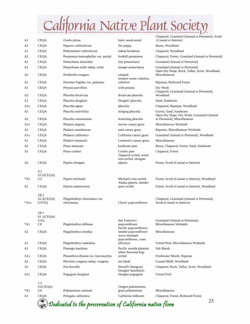
A1 CEQA Oxalis pilosa hairy wood-sorrel
Chaparral, Grassland (Annual or Perennial), Scrub
(Coastal or Interior)
A2 CEQA Papaver californicum fire poppy Burns, Woodland
A1 CEQA Pediomelum californicum indian breadroot Chaparral, Woodland
A2 CEQA Penstemon heterophyllus var. purdyi foothill penstemon Chaparral, Forest, Grassland (Annual or Perennial)
A2 CEQA Pentachaeta alsinoides tiny pentachaeta Grassland (Annual or Perennial)
A1 CEQA Pentachaeta exilis subsp. exilis meager pentachaeta Grassland (Annual or Perennial)
A2 CEQA Perideridia oregana yampah
Open Dry Slope, Rock, Tallus, Scree, Woodland,
Miscellaneous
A1 CEQA Petasites frigidus var. palmatus western sweet coltsfoot, coltsfoot Riparian, Redwood Forest
A1 CEQA Petunia parviflora wild petunia Dry Wash
A2 CEQA Phacelia divaricata divaricate phacelia
Chaparral, Grassland (Annual or Perennial),
Woodland
A1 CEQA Phacelia douglasii Douglas' phacelia Sand, Sandstone
A1x CEQA Phacelia egena phacelia Chaparral, Riparian, Woodland
A2 CEQA Phacelia malvifolia stinging phacelia Gravel, Sand, Sandstone
A2 CEQA Phacelia ramosissima branching phacelia
Open Dry Slope, Dry Wash, Grassland (Annual
or Perennial), Miscellaneous
A1x CEQA Phalaris angusta narrow canary grass Miscellaneous Wetlands
A2 CEQA Phalaris arundinacea reed canary grass Riparian, Miscellaneous Wetlands
A1x CEQA Phalaris californica California canary grass Grassland (Annual or Perennial), Woodland
A1 CEQA Phalaris lemmonii Lemmon's canary-grass Miscellaneous
A2 CEQA Pinus attenuata knobcone pine Burns, Chaparral, Forest, Sand, Sandstone
A2 CEQA Pinus coulteri Coulter pine Chaparral, Forest
A2 CEQA Piperia elongata
chaparral orchid, wood rein-orchid, elongate
piperia Forest, Scrub (Coastal or Interior)
*A2
4.2 S3.2(CEQA)
G3 Piperia michaelii Michael's rein-orchid Forest, Scrub (Coastal or Interior), Woodland
A1 CEQA Piperia unalascensis
Alaska piperia, slender-
spire orchid Forest, Scrub (Coastal or Interior), Woodland
*A1x
1B.2 S2.2(CEQA)
G3T2Q
Plagiobothrys chorisianus var.
chorisianus Choris' popcornflower
Chaparral, Grassland (Annual or Perennial),
Scrub (Coastal or Interior)
*A1
1B.1
S1.1(CEQA) G1Q
CE Plagiobothrys diffusus
San Francisco
popcornflower
Grassland (Annual or Perennial),
Miscellaneous Wetlands
A2 CEQA Plagiobothrys tenellus Pacific popcornflower, slender popcornflower Miscellaneous
A1 CEQA Plagiobothrys undulatus
wavy-stemmed
popcornflower, coast allocarya Vernal Pool, Miscellaneous Wetlands
A1 CEQA Plantago maritima Pacific seaside plantain Salt Marsh
A1x CEQA Platanthera dilatata var. leucostachys
white-flowered bog-
orchid Freshwater Marsh, Riparian
A2 CEQA Plectritis congesta subsp. congesta sea blush Coastal Bluff, Woodland
A2 CEQA Poa howellii Howell's bluegrass Chaparral, Rock, Tallus, Scree, Woodland
A1x CEQA Pogogyne douglasii
Douglas' beardstyle,
Douglas pogogyne Vernal Pool
*A1
2.2 S1(CEQA)
G4 Polemonium carneum
Oregon polemonium,
great polemonium Miscellaneous
A1 CEQA Polygala californica California milkwort Chaparral, Forest, Redwood Forest
24
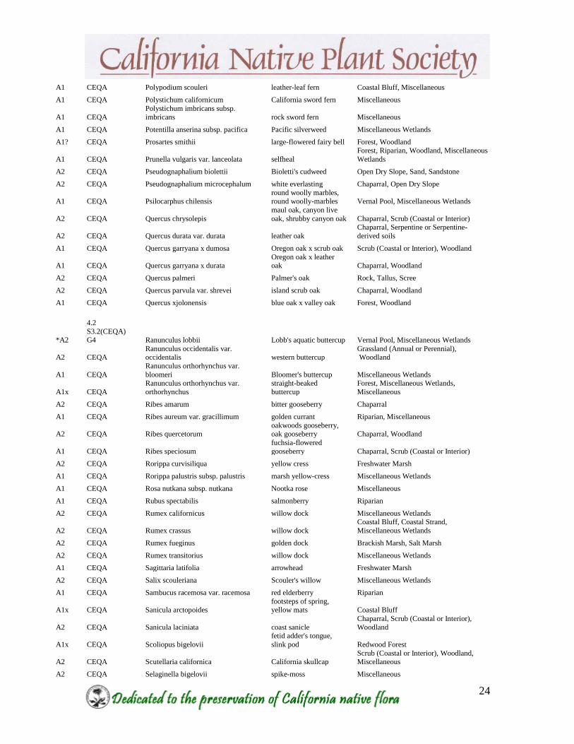
A1 CEQA Polypodium scouleri leather-leaf fern Coastal Bluff, Miscellaneous
A1 CEQA Polystichum californicum California sword fern Miscellaneous
A1 CEQA
Polystichum imbricans subsp.
imbricans rock sword fern Miscellaneous
A1 CEQA Potentilla anserina subsp. pacifica Pacific silverweed Miscellaneous Wetlands
A1? CEQA Prosartes smithii large-flowered fairy bell Forest, Woodland
A1 CEQA Prunella vulgaris var. lanceolata selfheal
Forest, Riparian, Woodland, Miscellaneous
Wetlands
A2 CEQA Pseudognaphalium biolettii Bioletti's cudweed Open Dry Slope, Sand, Sandstone
A2 CEQA Pseudognaphalium microcephalum white everlasting Chaparral, Open Dry Slope
A1 CEQA Psilocarphus chilensis round woolly marbles, round woolly-marbles Vernal Pool, Miscellaneous Wetlands
A2 CEQA Quercus chrysolepis
maul oak, canyon live
oak, shrubby canyon oak Chaparral, Scrub (Coastal or Interior)
A2 CEQA Quercus durata var. durata leather oak
Chaparral, Serpentine or Serpentine-
derived soils
A1 CEQA Quercus garryana x dumosa Oregon oak x scrub oak Scrub (Coastal or Interior), Woodland
A1 CEQA Quercus garryana x durata Oregon oak x leather oak Chaparral, Woodland
A2 CEQA Quercus palmeri Palmer's oak Rock, Tallus, Scree
A2 CEQA Quercus parvula var. shrevei island scrub oak Chaparral, Woodland
A1 CEQA Quercus xjolonensis blue oak x valley oak Forest, Woodland
*A2
4.2
S3.2(CEQA) G4 Ranunculus lobbii Lobb's aquatic buttercup Vernal Pool, Miscellaneous Wetlands
A2 CEQA Ranunculus occidentalis var. occidentalis western buttercup
Grassland (Annual or Perennial), Woodland
A1 CEQA
Ranunculus orthorhynchus var.
bloomeri Bloomer's buttercup Miscellaneous Wetlands
A1x CEQA
Ranunculus orthorhynchus var.
orthorhynchus
straight-beaked
buttercup
Forest, Miscellaneous Wetlands,
Miscellaneous
A2 CEQA Ribes amarum bitter gooseberry Chaparral
A1 CEQA Ribes aureum var. gracillimum golden currant Riparian, Miscellaneous
A2 CEQA Ribes quercetorum oakwoods gooseberry, oak gooseberry Chaparral, Woodland
A1 CEQA Ribes speciosum
fuchsia-flowered
gooseberry Chaparral, Scrub (Coastal or Interior)
A2 CEQA Rorippa curvisiliqua yellow cress Freshwater Marsh
A1 CEQA Rorippa palustris subsp. palustris marsh yellow-cress Miscellaneous Wetlands
A1 CEQA Rosa nutkana subsp. nutkana Nootka rose Miscellaneous
A1 CEQA Rubus spectabilis salmonberry Riparian
A2 CEQA Rumex californicus willow dock Miscellaneous Wetlands
A2 CEQA Rumex crassus willow dock
Coastal Bluff, Coastal Strand,
Miscellaneous Wetlands
A2 CEQA Rumex fueginus golden dock Brackish Marsh, Salt Marsh
A2 CEQA Rumex transitorius willow dock Miscellaneous Wetlands
A1 CEQA Sagittaria latifolia arrowhead Freshwater Marsh
A2 CEQA Salix scouleriana Scouler's willow Miscellaneous Wetlands
A1 CEQA Sambucus racemosa var. racemosa red elderberry Riparian
A1x CEQA Sanicula arctopoides footsteps of spring, yellow mats Coastal Bluff
A2 CEQA Sanicula laciniata coast sanicle
Chaparral, Scrub (Coastal or Interior),
Woodland
A1x CEQA Scoliopus bigelovii
fetid adder's tongue,
slink pod Redwood Forest
A2 CEQA Scutellaria californica California skullcap Scrub (Coastal or Interior), Woodland, Miscellaneous
A2 CEQA Selaginella bigelovii spike-moss Miscellaneous
25
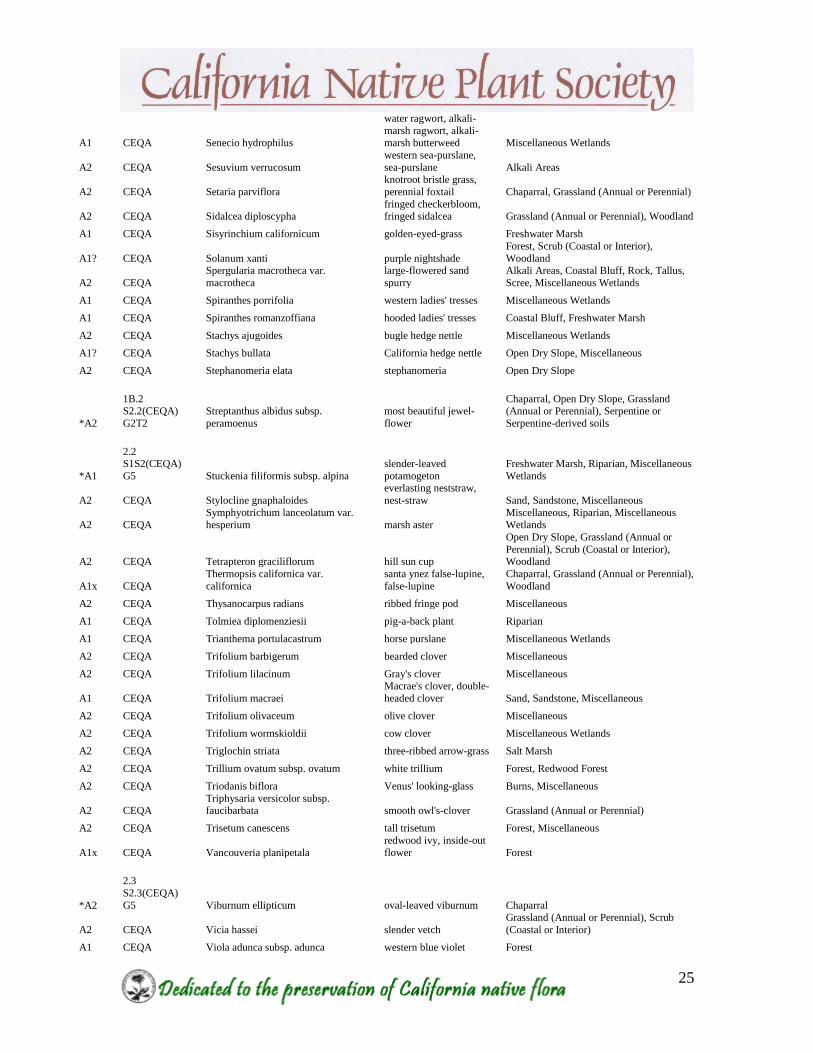
A1 CEQA Senecio hydrophilus
water ragwort, alkali-
marsh ragwort, alkali-marsh butterweed Miscellaneous Wetlands
A2 CEQA Sesuvium verrucosum
western sea-purslane,
sea-purslane Alkali Areas
A2 CEQA Setaria parviflora
knotroot bristle grass,
perennial foxtail Chaparral, Grassland (Annual or Perennial)
A2 CEQA Sidalcea diploscypha fringed checkerbloom, fringed sidalcea Grassland (Annual or Perennial), Woodland
A1 CEQA Sisyrinchium californicum golden-eyed-grass Freshwater Marsh
A1? CEQA Solanum xanti purple nightshade
Forest, Scrub (Coastal or Interior),
Woodland
A2 CEQA
Spergularia macrotheca var.
macrotheca
large-flowered sand
spurry
Alkali Areas, Coastal Bluff, Rock, Tallus,
Scree, Miscellaneous Wetlands
A1 CEQA Spiranthes porrifolia western ladies' tresses Miscellaneous Wetlands
A1 CEQA Spiranthes romanzoffiana hooded ladies' tresses Coastal Bluff, Freshwater Marsh
A2 CEQA Stachys ajugoides bugle hedge nettle Miscellaneous Wetlands
A1? CEQA Stachys bullata California hedge nettle Open Dry Slope, Miscellaneous
A2 CEQA Stephanomeria elata stephanomeria Open Dry Slope
*A2
1B.2 S2.2(CEQA)
G2T2
Streptanthus albidus subsp.
peramoenus
most beautiful jewel-
flower
Chaparral, Open Dry Slope, Grassland (Annual or Perennial), Serpentine or
Serpentine-derived soils
*A1
2.2 S1S2(CEQA)
G5 Stuckenia filiformis subsp. alpina
slender-leaved
potamogeton
Freshwater Marsh, Riparian, Miscellaneous
Wetlands
A2 CEQA Stylocline gnaphaloides
everlasting neststraw,
nest-straw Sand, Sandstone, Miscellaneous
A2 CEQA Symphyotrichum lanceolatum var. hesperium marsh aster
Miscellaneous, Riparian, Miscellaneous Wetlands
A2 CEQA Tetrapteron graciliflorum hill sun cup
Open Dry Slope, Grassland (Annual or
Perennial), Scrub (Coastal or Interior),
Woodland
A1x CEQA
Thermopsis californica var.
californica
santa ynez false-lupine,
false-lupine
Chaparral, Grassland (Annual or Perennial),
Woodland
A2 CEQA Thysanocarpus radians ribbed fringe pod Miscellaneous
A1 CEQA Tolmiea diplomenziesii pig-a-back plant Riparian
A1 CEQA Trianthema portulacastrum horse purslane Miscellaneous Wetlands
A2 CEQA Trifolium barbigerum bearded clover Miscellaneous
A2 CEQA Trifolium lilacinum Gray's clover Miscellaneous
A1 CEQA Trifolium macraei
Macrae's clover, double-
headed clover Sand, Sandstone, Miscellaneous
A2 CEQA Trifolium olivaceum olive clover Miscellaneous
A2 CEQA Trifolium wormskioldii cow clover Miscellaneous Wetlands
A2 CEQA Triglochin striata three-ribbed arrow-grass Salt Marsh
A2 CEQA Trillium ovatum subsp. ovatum white trillium Forest, Redwood Forest
A2 CEQA Triodanis biflora Venus' looking-glass Burns, Miscellaneous
A2 CEQA Triphysaria versicolor subsp. faucibarbata smooth owl's-clover Grassland (Annual or Perennial)
A2 CEQA Trisetum canescens tall trisetum Forest, Miscellaneous
A1x CEQA Vancouveria planipetala
redwood ivy, inside-out
flower Forest
*A2
2.3
S2.3(CEQA)
G5 Viburnum ellipticum oval-leaved viburnum Chaparral
A2 CEQA Vicia hassei slender vetch
Grassland (Annual or Perennial), Scrub
(Coastal or Interior)
A1 CEQA Viola adunca subsp. adunca western blue violet Forest

26
A2 CEQA Viola glabella
stream violet, smooth
yellow violet Forest, Riparian
A1 CEQA Viola sempervirens
evergreen violet,
redwood violet Redwood Forest
NOTE: Some of these plant species are only known from the area historically and have not been reported
for quite some time. It should not necessarily be assumed, however, that they no longer exist here as they
may be on private land or hard-to-reach areas where surveys have not been done for a long time, if ever. In
recent years, several plant species have been rediscovered in the East Bay that had not been reported in the
area since the late 1800’s or early 1900’s.
Dates indicated for historical species in the species name column refer to the last known record in the
Alameda-Contra Costa Counties area, not necessarily the area described in the title.
Explanation of Ranks
*A1 or *A2: Species in Alameda and Contra Costa counties listed as rare, threatened or endangered
statewide by federal or state agencies or by the state level of CNPS.
A1x: Species previously known from Alameda or Contra Costa Counties, but now presumed extirpated
here.
A1: Species currently known from 2 or less regions in Alameda and Contra Costa Counties.
A2: Species currently known from 3 to 5 regions in the two counties, or, if more, meeting other important
criteria such as small populations, stressed or declining populations, small geographical range, limited or
threatened habitat, etc.
A1?: Species with taxonomic or distribution problems that make it unclear if they actually occur here.
Appendix B
EBCNPS Comment Letter RE: Notice of Intent for the Environmental
Impact Statement on FEMA–2010–0037, Hazardous Fire Risk Reduction,
East Bay Hills, CA. October 2010
· · East Bay Chapter – California Native Plant Society – P.O. Box 5597, Elmwood Station, Berkeley, California 94705
California Native Plant Society East Bay Chapter
Conservation Committee
October 1, 2010
Office of Chief Counsel, Federal Emergency
Management Agency, 500 C Street, SW.,
Room 835, Washington, DC 20472–3100
RE: Docket ID: FEMA–2010–0037, Hazardous Fire Risk Reduction, East Bay Hills, CA
Dear Sir/Madam:
The East Bay Chapter of the California Native Plant Society (EBCNPS) appreciates the
opportunity to comment on the Notice of Intent for the Environmental Impact Statement on
FEMA–2010–0037, Hazardous Fire Risk Reduction, East Bay Hills, CA. The California
Native Plant Society (CNPS) is a non-profit organization of more than 10,000 laypersons,
professional and academic botanists organized into 33 chapters throughout California. The
mission of the CNPS is to increase the understanding and appreciation of California's native
plants and to preserve them in their natural habitat through scientific activities, education, and
conservation.
The East Bay Chapter of CNPS (EBCNPS) has been involved with protecting and conserving
native plant resources in the East Bay Hills for some 47 years now. These East Bay Hills are rich
with native vegetation and rare and unusual plants that often are found nowhere else in the two-
county East Bay area. The East Bay Hills are home to a large number of endangered, threatened,
and locally rare plants which could be affected by fuels management projects. EBCNPS wants to
ensure that the EIS will address potential impacts to these plants. Appendix A provides a list of
CEQA protected A-ranked plants, or plants that are locally rare, including federally listed and
state listed plants.
We recognize that there is a frightening wildfire potential each fall for some residents living in the East Bay Hills. This potential exists because of the combination of extreme weather events (Diablo winds), the pattern of residential development in the hills, the proximity of flammable homes to fire-prone vegetation, and the lack of adequate preparation to the urban infrastructure, including defensible space [excerpted from our paper, “Managing the East Bay Hills WUI to Preserve Native Habitat and Reduce the Risk of Catastrophic Fire”, Appendix B].
This paper, co-authored with Sierra Club and Golden Gate Audubon, was submitted to the East
Bay Park District during their Fuels Management EIR process. We believe that it is applicable to
this project and helps provide insight and information from three environmentally motivated
organizations. In addition to providing this paper and other letters to responsible parties,
EBCNPS continues to be in contact with landowners and land managers in the East Bay Hills,
including the City of Oakland and EBRPD, helping ensure that the fuels management plans for
these hills will not negatively impact native vegetation. In fact, in many cases we’re working
EBCNPS Conservation Committee
East Bay Chapter – Comments on FEMA Hazardous Fire Risk Reduction NOP 2
together to produce a win-win situation wherein both fuel reduction goals are met while native
plant habitat is maintained and even improved in some situations.
EBCNPS supports many of the concepts presented in the Sierra Club (SC) letter (Norman
LaForce, September 12th
, 2010) submitted during this project scoping process. EBCNPS has
been working assiduously with a number of local conservation groups, including the Sierra Club,
Golden Gate Audubon Society, Friends of Sausal Creek, and the Claremont Canyon
Conservancy, to help identify resources and educate the public and decision-makers about the
ecological value of these resources. We firmly agree with the second (2) point in the SC letter
that the EIS needs to be grounded in “verifiable wildfire science, reliable resource
protection/management science, and expert opinions”.
The role of FEMA, as a potential funder of these wildfire reduction plans, should be to review
the documents submitted not only for the quality of the project presented, but also for the
foundation upon which the proposals were written. We hope that FEMA would uphold grantees
to an extremely high standard and require the projects to explicitly state their assumptions and
the background information they have used to inform the proposed project. Although we
understand that all of the projects highlighted in the scoping session (e.g., City of Oakland,
University of California, EBRPD) have already submitted proposals, we believe that it is not too
late to assess the quality of these projects for the following parameters:
1. What type of fuel model is used to create the recommendations for fuels treatment? Is the
model generalized from another area or is it based on vegetation found in the East Bay
Hills and on an understanding of local weather phenomena?
2. Was the project proposal written with a demonstrated knowledge of the site-specific
natural resources and land conditions for each project? Did the project proposal team
include an ecologist, biologist, and botanist in order to help ensure that the project will
not create additional impacts to the environment? Was vegetation mapped at the
appropriate scale for each project? Since many projects will occur on a small scale, it
should be required that vegetation is mapped to the standards of the Manual of California
Vegetation – 2nd
Edition, so that resources and impacts to resources can be assessed at the
proper scale.
3. Do the proposals mention that they are working in “living landscapes”? Do these
proposals take into account the fact that the living environment will “respond” to the
changes proposed in each fuels management plan? The response of a living landscape to
perturbation isn’t always easy to predict, therefore, does the proposed project include a
number of possible scenarios that will occur 1, 5, and 10 years after the initial fuels
treatment? Does the project proponent have access to stable funding that will be able to
deal with costs of additional contingencies (i.e., erosion, invasive species spread, etc.)
that might arise after the FEMA funds are spent? How are these additional funds to be
spent if everything proceeds as planned?

EBCNPS Conservation Committee
East Bay Chapter – Comments on FEMA Hazardous Fire Risk Reduction NOP 3
4. Does the project proponent offer a clear and complete maintenance and monitoring plan
that will be initiated once the initial treatment is concluded?
5. Each project should have an approved Environmental Impact Report, or similar duly
prepared legal document, that has been properly noticed to the public and approved by the
proper agencies. The completion of the environmental review process, by the applicant,
should be a requirement before any project commences.
6. What is the track record of the applicant to finish projects as proposed? Since all of the
applicants have some history with fuels management work, how will past performance be
assessed for each applicant?
7. Does the applicant have an informed program for contending with weed and invasive
species that may colonize the site after fuels treatment?
8. Does the applicant have a technical advisory committee that would be helpful when
potential problems arise with fuels treatments or follow up monitoring?
General Considerations
FEMA’s EIS is required to consider all potential impacts that may occur from the act of FEMA
funding fuels reduction projects in the East Bay Hills. Given the history of fire in the East Bay
Hills, fear is a strong motivator for action that will help minimize the risk of catastrophic fire.
Although we agree that FEMA should act as quickly as possible, it does serve public safety or
our ecological heritage to act too quickly without considering the long-term consequences of this
scale of environmental manipulation. There are many associated impacts that could be
exaggerated with a poor fuels management plan, including but not limited to, flooding, erosion,
deterioration of water quality, deterioration of habitat for native flora and fauna, increased land
slides, and most importantly, increased risk of fire. We hope that FEMA clearly understands its
responsibilities if a fuels project has unintended consequences. We would like the document to
clearly outline FEMA’s actions after a project is approved, from contracts to reporting to follow-
up and enforcement.
FEMA’s EIS should include information on cumulative impacts to habitat. Since this project
will fund several million dollars of fuels work in the East Bay Hills, we believe that the funder of
this work should be required to take a landscape scale perspective of the greater proposed project
area. In this case, it seems likely that almost all of the impacts will fall upon a relatively small
area – the Berkeley and Oakland “Hills” areas where the urban areas are carved into steep hills
and lie adjacent to wildlands (parks, preserves, watershed lands). EBCNPS asks that the EIS
clearly state the acreage of each habitat type that will be affected and what habitat types will
replace these. We request that vegetation mapping be done at a fine scale and that vegetation be
reported as a vegetation type in accordance with the Manual of California Vegetation - 2nd
Edition.
EBCNPS Conservation Committee
East Bay Chapter – Comments on FEMA Hazardous Fire Risk Reduction NOP 4
FEMA’s EIS should include an impact analysis on the increase of the spread of invasive plants
from the proposed action. In addition, to help minimize the potential of increasing weed
invasion, we hope the EIS will clearly outline Best Management Practices as mitigation for all
grantees and contracts and enforce penalties if those BMPs are not implemented as agreed. At
least two mechanisms, with regard to invasive species spread, will be at play when a fuels
reduction project is undertaken. First, the actual act of bringing in machinery for fuels treatment
purposes poses a risk to the site. The equipment may be contaminated with seeds or vegetative
plant parts from another site and deposit weeds that were previously not known from the
immediate site. Second, the process of soil disturbance is one of the major factors in increasing
weed populations, as well as introducing new colonizers. Barren soil or soil that has been
disturbed by machinery or mechanical tools is more likely to be colonized by invasive species
than soil which remains intact. Most of our invasive plants thrive in disturbed soils, and fuels
management work therefore provides a vector by which weeds can spread. In some cases, the
implications of increased weed biomass can be significant. Many weeds are extremely
competitive and produce large amounts of biomass that crowd out native plants. As a result,
often the weeds can be as great or greater a fire hazard than the native vegetation that was
managed for fuel load. EBCNPS believes that this scenario needs to be addressed in the EIS and
FEMA should be clear about monitoring requirements over the course of 2-5 years to ensure that
this will not be the outcome of the proposed projects. We believe FEMA should require annual
project reports for 3 to 5 years and require that the grantee make these reports easily available to
the public.
FEMA’s EIS should require monitoring for all projects that it approves and funds. As stated in
the above points, monitoring will help ensure that projects are compliant with FEMA standards,
and even more importantly, that environmental conditions have not been degraded for resources,
people, or wildlife at the cost of fuels management. Although FEMA has clearly stated that its
funding cannot go towards monitoring and follow-up activities, it should require that an agency
has matching funding at a rate of 1:3 or 1:4 for monitoring and follow-up activities that are
needed for a successful project. Projects that lack monitoring and follow-up often produce less
desirable results and can negatively impact the project site. FEMA’s EIS should clearly state that
the funding for any approved project has the appropriate matching funds (at a reasonable ratio) so
that monitoring and follow-up tasks can make FEMA-funded projects successful and accountable
to the community in which they take place.
Thank you for your consideration of the above comments. Please do not hesitate to contact me
with questions at (510) 734-0335.
Sincerely,
Lech Naumovich
Conservation Analyst
California Native Plant Society
East Bay Chapter

EBCNPS Conservation Committee
East Bay Chapter – Comments on FEMA Hazardous Fire Risk Reduction NOP 5
APPENDIX A: CEQA protected A-Ranked Plants known from the East Bay Hills
East Bay
Rarity
Rank Species Name Common Name Habitat
A1 Acer negundo var. unknown
(var. californicum is the most
common)
box-elder Riparian
A2 Adiantum aleuticum (A.
jordanii is more common)
five-finger fern Riparian
A1 Agoseris apargioides var.
apargioides
seaside agoseris Forest; Grassland; Scrub; Sand or
Sandstone
A2 Allium falcifolium sickle-leaved onion Rock, Tallus or Scree; Serpentine
A2 Alnus rubra (A. rhombifolia
is more common)
red alder Riparian
A1 Ammannia coccinea long-leaved ammannia Riparian areas; Misc. Wetlands
A1x Amsinckia douglasiana
(historical-1938)
Douglas' fiddleneck Dry Open Slopes; Rock, Tallus or
Scree
*A2 AMSINCKIA LUNARIS bent-flowered fiddleneck Grassland; Woodland; Misc. habitats
A1 Anisocarpus madioides
(Madia madioides in Jepson
Manual)
woodland madia Forest; Redwood Forest; Woodland
A2 Apiastrum angustifolium wild celery Chaparral; Scrub
A2 Arctostaphylos glandulosa
ssp. glandulosa
Eastwood manzanita Chaparral
*A1 ARCTOSTAPHYLOS
PALLIDA
pallid manzanita Chaparral; Sand or Sandstone
A2 Asclepias speciosa (A.
californica is more common)
milkweed Misc. habitats
A2 Aster lanceolatus ssp.
hesperius
marsh aster Riparian areas; Misc. Wetlands; Misc.
habitats
*A1 ASTRAGALUS TENER
VAR. TENER
alkali milk-vetch Alkali areas; Grassland; Vernal Pools;
Misc. Wetlands
A1x Atriplex patula ssp. obtusa
(historical-1897)
spear saltbush Alkali areas
*A1 BALSAMORHIZA
MACROLEPIS VAR.
MACROLEPIS
big-scale balsamroot Grassland; Serpentine
A1x Calamagrostis nutkaensis
(historical-18??)
Pacific reed grass Coastal Strand; Freshwater Marsh;
Forest; Redwood Forest
*A2 CALOCHORTUS
UMBELLATUS
Oakland star-tulip Chaparral; Scrub; Woodland
A1 Calycadenia multiglandulosa sticky calycadenia Rock, Tallus or Scree; Scrub
A2 Camissonia graciliflora hill sun cup Dry Open Slopes; Grassland; Scrub;
Woodland
A1 Carex brevicaulis short-stemmed sedge Rock, Tallus or Scree; Sand or
Sandstone areas
A2 Carex densa dense sedge Misc. Wetlands; Misc. habitats
A1 Carex deweyana ssp.
leptopoda
short-scaled sedge Misc. Wetlands; Misc. Habitats
A1 Carex dudleyi Dudley's sedge Misc. Wetlands
A1 Carex globosa round-fruited sedge Misc. habitats

EBCNPS Conservation Committee
East Bay Chapter – Comments on FEMA Hazardous Fire Risk Reduction NOP 6
A1x Carex gracilior (historical-
1939)
slender sedge Forest; Grassland; Misc. Wetlands;
Misc. habitats
A2 Carex multicostata many-ribbed sedge Misc. habitats
A1 Carex obnupta slough sedge Misc. Wetlands
A1 Castilleja ambigua ssp.
ambigua
Johnny-nip Coastal Bluff; Grassland
A2 Castilleja subinclusa ssp.
franciscana
Franciscan Indian paintbrush Chaparral; Scrub
A2 Ceanothus thyrsiflorus var.
thyrsiflorus
blue blossom; California-lilac Misc. habitats
A1 Chorizanthe polygonoides
var. polygonoides
knotweed spineflower Gravel; Sand or Sandstone
A2 Chrysolepis chrysophylla var.
minor
golden chinquapin Chaparral; Forest; Sand or Sandstone
A2 Cirsium quercetorum brownie thistle Grassland; Woodland
*A1 CLARKIA FRANCISCANA Presidio clarkia Serpentine
A2 Clarkia purpurea ssp. viminea
(ssp. quadrivulnera is more
common)
large godetia Misc. habitats
A1 Clintonia andrewsiana red clintonia Redwood Forest
A2 Collomia heterophylla varied-leaved collomia Rock, Tallus or Scree; Sand or
Sandstone areas
A2 Corallorhiza maculata fma.
maculata (forma immaculata
is more common)
spotted coralroot Forest; Woodland
A1 Corallorhiza striata (C.
maculata is more common)
striped coralroot Forest; Woodland
A1 Coreopsis stillmanii Stillman's coreopsis Chaparral; Grassland; Serpentine;
Woodland
A1 Cryptantha micromeres minute-flowered cryptantha Chaparral; Woodland
A2 Cryptantha muricata prickly cryptantha Rock, Tallus or Scree; Sand or
Sandstone areas
A2 Cryptantha torreyana Torrey's cryptantha Dry Open Slopes; Forest
A2 Cyperus erythrorhizos red-rooted cyperus Riparian
A2 Deinandra corymbosa ssp.
corymbosa (Hemizonia
corymbosa in Jepson Manual)
coast tarweed Coastal Bluff; Grassland
A2 Dendromecon rigida bush poppy Burns; Chaparral; Scrub
A2 Deschampsia cespitosa ssp.
holciformis
tufted hairgrass Misc. Wetlands
A2 Dicentra formosa bleeding heart Forest; Redwood Forest; Misc.
habitats
A1? Dichelostemma volubile(?) twining brodiaea Scrub; Woodland
*A2 DIRCA OCCIDENTALIS western leatherwood Forest; Riparian; Scrub
A1? Disporum smithii(?) (D.
hookeri is more common)
large-flowered fairy bell Forest; Woodland
A2 Echinodorus berteroi burhead Freshwater Marsh
A2 Elymus glaucus ssp. jepsonii
(ssp. glaucus is more
common)
blue wildrye Grassland
A2 Elymus X hansenii Hansen squirreltail Grassland
A1 Eragrostis mexicana ssp. Orcutt's eragrostis Riparian areas; Sand or Sandstone

EBCNPS Conservation Committee
East Bay Chapter – Comments on FEMA Hazardous Fire Risk Reduction NOP 7
virescens areas; Misc. habitats
A2 Ericameria arborescens golden-fleece Chaparral; Forest; Woodland
A2 Erigeron petrophilus var.
petrophilus
rock daisy Rock, Tallus or Scree; Serpentine
*A1 ERIOGONUM LUTEOLUM
VAR. CANINUM
Tiburon buckwheat Grassland; Serpentine
A2 Eriogonum luteolum var.
luteolum
golden carpet Gravel; Sand or Sandstone; Serpentine
*A2 ERODIUM
MACROPHYLLUM
round-leaved filaree Grassland; Scrub
A2 Festuca elmeri Elmer's fescue Riparian
*A1 FRITILLARIA LILIACEA fragrant fritillary Grassland; Serpentine; Vernal Pools
*A2 GALIUM ANDREWSII
SSP. GATENSE
serpentine bedstraw Chaparral; Serpentine; Woodland
A1 Gaultheria shallon salal Forest; Redwood Forest
A2 Githopsis diffusa ssp. robusta southern bluecup Burns; Misc. habitats
A2 Gnaphalium bicolor Bioletti's cudweed Dry Open Slopes; Sand or Sandstone
A2 Gnaphalium canescens ssp.
microcephalum
white everlasting Chaparral; Dry Open Slopes
*A2 HELIANTHELLA
CASTANEA
Diablo helianthella Chaparral; Grassland; Woodland
A2 Hesperolinon californicum California dwarf flax Grassland; Rock, Tallus or Scree;
Serpentine
A1x Hierochloe occidentalis
(historical-198? but not seen
since)
vanilla grass Forest; Redwood Forest
A2 Hoita macrostachya California hemp Freshwater Marsh; Riparian
A1x Hoita orbicularis (historical-
1936)
round-leaved psoralea Riparian areas; Misc. habitats
*A1x HOITA STROBILINA
(HISTORICAL-1865)
Loma Prieta hoita Chaparral; Woodland
A2 Hordeum jubatum foxtail barley Misc. habitats
A1 Horkelia californica ssp.
californica
California horkelia Grassland; Scrub
*A1x HORKELIA CUNEATA
SSP. SERICEA
(HISTORICAL-1894)
Kellogg's horkelia Grassland; Scrub; Sand or Sandstone
A1 Hypericum formosum var.
scouleri
Scouler's St. John's wort Freshwater Marsh; Riparian
A2 Iris douglasiana Douglas iris Misc. habitats
A1 Iris longipetala field iris Misc. habitats
*A2 LATHYRUS JEPSONII
VAR. JEPSONII
Delta tule pea Brackish Marsh; Freshwater Marsh
A2 Layia gaillardioides woodland layia Scrub; Woodland
A1x Layia glandulosa (historical-
1983 but not seen since)
white layia Sand or Sandstone
A2 Layia hieracioides tall layia Misc. habitats
A1x Lepidium oblongum var.
oblongum (historical-1937)
wayside pepper-grass Misc. habitats
A1 Ligusticum apiifolium Pacific lovage Coastal Bluff; Grassland; Scrub;
Woodland
A2 Lilium pardalinum ssp. leopard lily Freshwater Marsh; Riparian
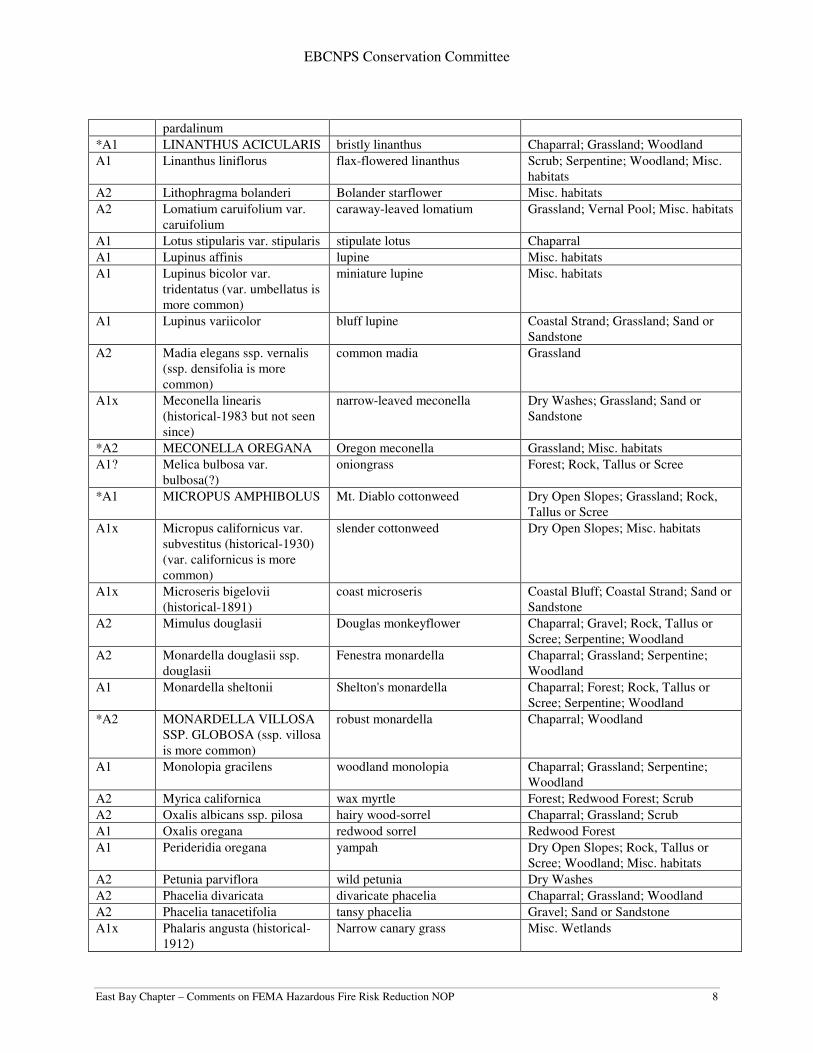
EBCNPS Conservation Committee
East Bay Chapter – Comments on FEMA Hazardous Fire Risk Reduction NOP 8
pardalinum
*A1 LINANTHUS ACICULARIS bristly linanthus Chaparral; Grassland; Woodland
A1 Linanthus liniflorus flax-flowered linanthus Scrub; Serpentine; Woodland; Misc.
habitats
A2 Lithophragma bolanderi Bolander starflower Misc. habitats
A2 Lomatium caruifolium var.
caruifolium
caraway-leaved lomatium Grassland; Vernal Pool; Misc. habitats
A1 Lotus stipularis var. stipularis stipulate lotus Chaparral
A1 Lupinus affinis lupine Misc. habitats
A1 Lupinus bicolor var.
tridentatus (var. umbellatus is
more common)
miniature lupine Misc. habitats
A1 Lupinus variicolor bluff lupine Coastal Strand; Grassland; Sand or
Sandstone
A2 Madia elegans ssp. vernalis
(ssp. densifolia is more
common)
common madia Grassland
A1x Meconella linearis
(historical-1983 but not seen
since)
narrow-leaved meconella Dry Washes; Grassland; Sand or
Sandstone
*A2 MECONELLA OREGANA Oregon meconella Grassland; Misc. habitats
A1? Melica bulbosa var.
bulbosa(?)
oniongrass Forest; Rock, Tallus or Scree
*A1 MICROPUS AMPHIBOLUS Mt. Diablo cottonweed Dry Open Slopes; Grassland; Rock,
Tallus or Scree
A1x Micropus californicus var.
subvestitus (historical-1930)
(var. californicus is more
common)
slender cottonweed Dry Open Slopes; Misc. habitats
A1x Microseris bigelovii
(historical-1891)
coast microseris Coastal Bluff; Coastal Strand; Sand or
Sandstone
A2 Mimulus douglasii Douglas monkeyflower Chaparral; Gravel; Rock, Tallus or
Scree; Serpentine; Woodland
A2 Monardella douglasii ssp.
douglasii
Fenestra monardella Chaparral; Grassland; Serpentine;
Woodland
A1 Monardella sheltonii Shelton's monardella Chaparral; Forest; Rock, Tallus or
Scree; Serpentine; Woodland
*A2 MONARDELLA VILLOSA
SSP. GLOBOSA (ssp. villosa
is more common)
robust monardella Chaparral; Woodland
A1 Monolopia gracilens woodland monolopia Chaparral; Grassland; Serpentine;
Woodland
A2 Myrica californica wax myrtle Forest; Redwood Forest; Scrub
A2 Oxalis albicans ssp. pilosa hairy wood-sorrel Chaparral; Grassland; Scrub
A1 Oxalis oregana redwood sorrel Redwood Forest
A1 Perideridia oregana yampah Dry Open Slopes; Rock, Tallus or
Scree; Woodland; Misc. habitats
A2 Petunia parviflora wild petunia Dry Washes
A2 Phacelia divaricata divaricate phacelia Chaparral; Grassland; Woodland
A2 Phacelia tanacetifolia tansy phacelia Gravel; Sand or Sandstone
A1x Phalaris angusta (historical-
1912)
Narrow canary grass Misc. Wetlands

EBCNPS Conservation Committee
East Bay Chapter – Comments on FEMA Hazardous Fire Risk Reduction NOP 9
A2 Phalaris arundinacea reed canary grass Riparian areas; Misc. Wetlands
A1x Phalaris californica
(historical-1943)
California canary grass Grassland; Woodland
A1 Phalaris lemmonii Lemmon's canary-grass Misc. habitats
A2 Pinus attenuata knobcone pine Chaparral; Forest; Sand or Sandstone
A2 Piperia elongata elongate piperia Forest; Scrub
A1 Piperia unalascensis Alaska piperia Forest; Scrub; Woodland
*A1x PLAGIOBOTHRYS
CHORISIANUS VAR.
CHORISIANUS (historical-
1890)
Choris's popcorn flower Chaparral; Grassland; Scrub
*A1 PLAGIOBOTHRYS
DIFFUSUS
San Francisco popcorn flower Grassland; Misc. Wetlands
A2 Plagiobothrys tenellus slender popcornflower Misc. habitats
A1 Polypodium scouleri leather-leaf fern Coastal Bluff; Misc. habitats
A1 Polystichum californicum California sword fern Misc. habitats
A1 Polystichum imbricans var.
imbricans
rock sword fern Misc. habitats
*A1 POTAMOGETON
FILIFORMIS
slender-leaved potamogeton Freshwater Marsh; Riparian; Misc.
Wetlands
A1 Prunella vulgaris var.
lanceolata (var. vulgaris is
more common)
selfheal Forest; Riparian; Woodland; Misc.
Wetlands
A1 Psilocarphus tenellus var.
globiferus (var. tenellus is
more common)
round woolly-marbles Vernal Pools; Misc. Wetlands
A1 Quercus parvula var. shrevii island scrub oak Chaparral; Woodland
A1 Ranunculus orthorhynchus
var. bloomeri
Bloomer's buttercup Misc. Wetlands
A1 Ribes amarum bitter gooseberry Chaparral
A1 Ribes speciosum fuchsia-flowered gooseberry Chaparral; Scrub
A2 Rorippa palustris var.
occidentalis
marsh yellow-cress Misc. Wetlands
A1 Rosa nutkana var. nutkana Nootka rose Misc. habitats
A2 Rumex maritimus golden dock Brackish Marsh; Salt Marsh
A2 Rumex salicifolius var.
denticulatus
willow dock Misc. Wetlands
A1 Sagittaria latifolia arrowhead Freshwater Marsh
A2 Salix scouleriana Scouler's willow Misc. Wetlands
A1 Sambucus racemosa var.
racemosa
red elderberry Riparian
A1x Sanicula arctopoides
(historical-19??)
footsteps-of-spring Coastal Bluff
A2 Sanicula laciniata coast sanicle Chaparral; Scrub; Woodland
A1x Scoliopus bigelovii
(historical-18??)
fetid adder's tongue; slink pod Redwood Forest
A2 Scutellaria californica California skullcap Scrub; Woodland; Misc. habitats
A2 Spergularia macrotheca var.
macrotheca
large-flowered sand spurry Alkali areas; Coastal Bluff; Rock,
Tallus or Scree; Misc. Wetlands
A1 Spiranthes porrifolia western ladies' tresses Misc. Wetlands
A1 Spiranthes romanzoffiana hooded ladies' tresses Coastal Bluff, Freshwater Marsh
A1? Stachys bullata(?) (S. California hedge nettle Dry Open Slopes; Misc. habitats

EBCNPS Conservation Committee
East Bay Chapter – Comments on FEMA Hazardous Fire Risk Reduction NOP 10
ajugoides var. rigida is more
common)
A2 Stephanomeria elata stephanomeria Dry Open Slopes
*A2 STREPTANTHUS
ALBIDUS SSP.
PERAMOENUS
most beautiful jewel-flower Chaparral; Dry Open Slopes;
Grassland; Serpentine
A1x Thermopsis macrophylla var.
macrophylla (historical-1929)
false-lupine Chaparral; Grassland; Woodland
A2 Thysanocarpus radians ribbed fringe pod Misc. habitats
A1 Tolmiea menziesii pig-a-back plant Riparian
A2 Trifolium macraei double-headed clover Sand or Sandstone; Misc. habitats
A2 Trifolium wormskioldii cow clover Misc. Wetlands
A2 Trillium ovatum ssp. ovatum white trillium Forest; Redwood Forest
A2 Triodanis biflora Venus' looking-glass Misc. habitats
A2 Triphysaria versicolor ssp.
faucibarbata
smooth owl's-clover Grassland
A2 Trisetum canescens tall trisetum Forest; Misc. habitats
A2 Tropidocarpum gracile slender tropidocarpum Alkali areas; Grassland
A1x Vancouveria planipetala
(historical-1898)
inside-out flower Forest
A2 Vicia hassei slender vetch Grassland; Scrub
A1 Viola adunca western blue violet Forest
A2 Viola glabella stream violet Forest; Riparian
A1 Viola sempervirens evergreen violet Redwood Forest NOTE: Some of these plant species are only known from the area historically and have not been reported for quite
some time. It should not necessarily be assumed, however, that they no longer exist here as they may be on private
land or hard-to-reach areas where surveys have not been done for a long time, if ever. In recent years, several plant
species have been rediscovered in the East Bay that had not been reported in the area since the late 1800’s or early
1900’s.
Dates indicated for historical species in the species name column refer to the last known record in the Alameda-
Contra Costa Counties area, not necessarily the area described in the title.
Explanation of Ranks
*A1 or *A2: Species in Alameda and Contra Costa counties listed as rare, threatened or endangered statewide by
federal or state agencies or by the state level of CNPS.
A1x: Species previously known from Alameda or Contra Costa Counties, but now presumed extirpated here.
A1: Species currently known from 2 or less regions in Alameda and Contra Costa Counties.
A2: Species currently known from 3 to 5 regions in the two counties, or, if more, meeting other important criteria
such as small populations, stressed or declining populations, small geographical range, limited or threatened habitat,
etc. A1?: Species with taxonomic or distribution problems that make it unclear if they actually occur here.

EBCNPS Conservation Committee
East Bay Chapter – Comments on FEMA Hazardous Fire Risk Reduction NOP 11
APPENDIX B: Green Paper on Fuels Management in the East Bay Hills
Managing the East Bay Hills Wildland/Urban Interface to Preserve Native Habitat and Reduce the Risk of Catastrophic Fire
An Environmental Green Paper- March 27, 2009
Sierra Club, California Native Plant Society, Golden Gate Audubon Society
This paper has been prepared by the San Francisco Bay Chapter of the Sierra Club (Sierra Club), East Bay Chapter of the California Native Plant Society (CNPS) and the Golden Gate Audubon Society (Audubon) to document our point of view about how best to meet the twin goals of managing the urban wildland interface to enhance and preserve habitat for native plants and wildlife species while reducing the threat of catastrophic fire at the interface.
This topic is of timely importance because of the pending release of the environmental review documents being prepared by the East Bay Regional Park District, FEMA grants for vegetation management, and other agency documents that are to follow. This paper contains the major guiding principles, which are further elaborated on in the attached background paper and appendix.
It is important to note at the outset that we embrace an Integrated Fire Management (IFM) approach to this issue. An IFM approach addresses the total scope of fire hazard both from problems with the human infrastructure and those from wildland vegetation.
We apply this theme at both the landscape level as well as at individual sites, whether they are homes at the interface or public parks and open space. While the human infrastructure including roads, water supply, defensible neighborhoods, etc., is expensive to maintain or improve, only well-planned infrastructure can assure safety from catastrophic fire. Without that fundamental understanding, vegetation management projects are doomed to fail in meeting the twin goals of fire safety and conservation of native habitat.
GUIDING PRINCIPLES
Background
We recognize that there is a frightening wildfire potential each fall for some residents living in the East Bay Hills. This potential exists because of the combination of extreme weather events (Diablo winds), the pattern of residential development in the hills, the proximity of flammable homes to fire-prone vegetation, and the lack of adequate preparation to the urban infrastructure, including defensible space.
Natural wildfire in wildland areas can be viewed as an event without serious consequences to humans, but at the wildland/urban interface where man has altered natural conditions, it can lead to a disaster. There are natural cycles that are unavoidable that we must pay attention to, prepare for, and be ready to respond to appropriately and sometimes quickly. As an example, during the 21st century the East Bay Hills will not be lucky enough, even with exceptional fire fighting, to get by with zero uncontrollable wildfires and zero extremes in weather. Diablo winds in the fall months are the key environmental factor for extreme fire behavior, and it will be impossible to know the exact location, source, and timing of an ignition that will transform high winds into a raging wildfire.
EBCNPS Conservation Committee
East Bay Chapter – Comments on FEMA Hazardous Fire Risk Reduction NOP 12
During some Diablo Wind wildfires there will not be enough firefighters, fire trucks, helicopters, or aircraft to save every house or even control the fire until the winds slow. Unlike “normal” fires that can be fought, to a certain extent on the ground, Diablo Wind fires prevent the placement of firefighters on steep slopes or other hazardous locations due to the speed of wind-driven fire. Under these circumstances, quick evacuation and homeowners insurance will be the only protection for residents who have lost property.
Recent reports compiled by firefighters and researchers in “lessons learned” from other catastrophic wildland/urban interface fires in California have shown that the most important factor in preventing homes from burning in wildland fires is hardening of structures and the creation of defensible space. Conversely, unprepared residential areas will likely not be saved during a wind-driven wildfire and will contribute to the rapid spread of wildfire into adjacent residential areas as happened during the 1991 Oakland/Berkeley Tunnel Fire.
The 1995 Hills Emergency Forum Plan did not receive full acceptance from the environmental community because it contained insufficient field collected data to support the designations of fuel characteristics of our local vegetation, did not take into account the importance of conserving native habitat, and did not include a legally required environmental document along with the Plan.
The 1995 HEF Plan recommended that public agencies and large acreage landowners create and maintain two different types of areas managed for fuel reduction in the East Bay Hills. The first are the ridgetop fuelbreaks that were begun after the freeze of 1972 by removing freeze damaged eucalyptus to achieve a 300’ wide zone of managed vegetation where firefighters could attempt to stop a fire that started in wildland areas to the east, before it could race over the ridge into residential areas. The second type of management was created after the 1982 Blue Ribbon Report and the 1995 HEF Plan. The 1982 Report recommended fuelbreaks designed to provide a minimum of 100 feet of managed vegetation (including what the homeowner is required to do for defensible space) at the wildland/urban edge. The 1995 HEF Plan recommended fuelbreaks within a 500 foot study area, that in itself became controversial and confusing, designed to provide an area of managed vegetation with less than eight-foot flame lengths at the wildland/urban edge where firefighters could safely work to protect homes.
The Sierra Club, CNPS, and Audubon have not been satisfied with the Park District’s approach for maintaining its fuel-managed areas. We know that fuelbreaks constitute a combined area of more than 20 miles and 500 acres, often covered by weedy species, mowed below 4” of height, or over-grazed by goats, with little concern about species or habitat values. Also several eucalyptus management, thinning, or conversion projects exist that need attention. We are concerned that the Park District’s consultants and its staff have yet to articulate a clear vision about how they intend to maintain these areas while favoring and increasing the percentage of native plants over weedy, fuel-rich non-natives.
The debate about wildfire risks attributed to non-native eucalyptus trees has been a controversial topic for years. In our opinion, there is ample evidence to show that eucalyptus and pine trees in dense unmanaged groves are both a wildfire threat and an environmental dilemma that requires attention. Non-native eucalyptus and pine groves can exceed 120’ in height and can be prone to dramatic fire behavior. When wind- driven wildfire reaches tree crowns, flames above 150’ can be expected with burning embers blowing downwind well beyond one half mile. The capacity to spot new fires that overwhelm firefighting forces during Diablo Wind conditions means these species must receive high priority for treatment.

EBCNPS Conservation Committee
East Bay Chapter – Comments on FEMA Hazardous Fire Risk Reduction NOP 13
Selected and representative quotes, articles, and reports that provide additional information and perspective about the fire hazards and the environmental dilemmas posed by eucalyptus and pine plantations in the East Bay Hills can be found in the Background to the Environmental Green Paper.
Recommendations and Solutions
In our opinion, decisions about how best to manage our east bay hill vegetation on the wildland side should be based on the twin goals of reducing the risk of catastrophic fire and maintaining the fragile native habitat found in the wildland/urban interface. To accomplish these goals, agencies should formulate well-conceived plans that integrate natural resource sciences and fire science.
All plans to reduce vegetation on the wildland side must be site specific, taking into account a range of critical variables that result in an individual profile for each site. We do not endorse generic fuel prescriptions because they do not take into account the unique threats and values of each site. In order to accomplish the twin goals of reducing the risk of catastrophic fires and of maintaining sustainable native habitat, agencies must recognize that effective management of live fuels is a subset of sound land management (and not the other way around) primarily because of the high degree of variability of living landscapes.
We urge the Hills Emergency Forum (HEF) and its member agencies to prepare updated mapping systems for the East Bay hills that identify wildland plant communities in site-specific detail as well as the type and density of vegetation intermixed with home landscapes.
Native vegetation communities, including our native woodlands, are generally below 40’ in height, and are less prone to unmanageable fire behavior. These communities are comprised predominantly of plants that are native to the East Bay and form more than 80% of today’s wildland vegetation in the hills. The recommended strategy for protecting residential areas from wildfire coming from native vegetation is to establish an understanding of the ecology and fire-behavior of the fuels site-specific to each individual wildland/residential edge, and then manage these edges to provide safe access for firefighters defending structures that are able to resist burning embers and to hopefully stop fire before it enters residential areas.
As each agency prepares their individual plans and environmental documents, they will be required to address the cumulative impacts of wildland fire hazard reduction projects by all agencies. This will require active cooperation and long range planning by HEF member agencies. We will reserve our final opinion about how each agency handles these matters as we review their plans and environmental documents.

EBCNPS Conservation Committee
East Bay Chapter – Comments on FEMA Hazardous Fire Risk Reduction NOP 14
Enhancing and Preserving our Natural Environment While Reducing the Risk of Catastrophic Fire
Background to the Environmental Green Paper This Background Paper has been prepared by the Sierra Club (Sierra Club), East Bay Chapter of the California Native Plant Society (CNPS) and the Golden Gate Audubon Society (Audubon) to document our positions on several of the issues that are important to us as we explore options for meeting the twin goals of enhancing and preserving native plants and wildlife while reducing the threat of catastrophic fire at the Wildland Urban Interface in the East Bay Hills. This topic is of timely importance because of the pending release of the environmental review documents being prepared by the East Bay Regional Park District, FEMA grants for vegetation management, and other agency documents that are to follow. We would have preferred working with and commenting on a single draft wildfire hazard reduction plan and environmental document for the East Bay Hills with a free exchange of ideas, concepts, and details presented to and discussed with experts and stakeholders who have been involved in these matters for the past 15-years. This would have provided for an Integrated Fire Management approach at all levels, both in content and process, and among all-important stakeholders. This was the type of process that we expected after the Park District’s Temescal workshops of 2000, and is consistent with our understanding of how the Park District Plan/EIR/EIS should have been developed. With that understanding, we supported Measure CC in 2004 including the $10 million for District projects and a joint fire hazard mitigation plan that was to involve Hills Emergency Forum (HEF) agencies. Thus, we were disappointed that the HEF decided three years ago that each agency should proceed with individual plans and environmental documents. The East Bay Municipal Utility District and the University of California had already completed their Land Use Master Plans, with Berkeley, Kensington, and El Cerrito not contemplating plans for their residential areas. The next to emerge will be the Park District’s Plan/EIR that has been under development during the past two years. The consultant’s draft Plan is currently being reviewed by Park District staff that will recommend several changes in the draft, followed by a public review document that is nearing completion. We also understand that Oakland intends to prepare its plan and environmental document following completion of the Park District Plan/EIR. In our opinion, staff and consultants have developed the Draft Park District Plan in relative isolation instead of taking more time to "get specific" with recognized experts and stakeholders. True, there were four informational meetings at the Trudeau Center with consultant and staff presentations, and time for public comment. However, the District’s Plan/EIR process to date, has offered little detail, so it’s anyone’s guess about what will be in the draft documents soon to be released for public review. We have seen very little in the way of detailed resource information, and have not been informed about which federal agency the District will use to obtain required biological opinions necessary to make its Plan/EIR complete. In the event the draft, which we have not seen, requires substantial changes or additions, we support the use of additional Measure CC funds, District funds, or use of grant funds to complete a Plan/EIR document that will be useful and supported by the environmental community and other stakeholders.
EBCNPS Conservation Committee
East Bay Chapter – Comments on FEMA Hazardous Fire Risk Reduction NOP 15
In the meantime, the District has proceeded with fuels management based on very little oversight by its own stewardship department and with a FEMA EA that covered only federally listed plant and animal species. The result has been fuels management executed without the benefit of clearly derived policy. Meanwhile the actual vegetation management projects taking place in some areas have been fraught with controversy. We also are aware that three Federal Emergency Management Agency (FEMA) competitive grants have been awarded to the University (Strawberry and Claremont Canyons), to the City of Oakland (Frowning Ridge), and to the Park District (East Bay Hills Area) for fire hazard reduction projects. These grants will require three different project level FEMA Environmental Assessments. As with EBRPD, one of the consequences of this kind of haphazard approach has been the creation of de facto policy on the part of UC, the City of Oakland, and various stewardship groups in terms of on-the-ground management of vegetation. These policies have not had the benefit of public, scientific vetting and in some cases have now found their way into federal policy. Without proper vetting, these activities have resulted in mixed results. It is important to note at the outset that an Integrated Fire Management approach means that the total scope of fire hazard (both from human infrastructure and from vegetation) will be considered as a first step, both in the wide scope of the East Bay Hills Wildland Urban Interface and in individual sites that are identified for some form of action. While vegetation management is surely an important part of the total picture, it must not be the tail that wags the dog as it has been in the past, particularly after the ’91 fire. While the human infrastructure including roads, water supply, defensible neighborhoods, etc., is expensive to maintain or improve, only well-planned infrastructure can assure safety from catastrophic fire. The National Firewise Communities program has made that clear. By its very nature, the living landscape involves far more variability and therefore attempting to manage it means a certain lack of predictability. Without that fundamental understanding, vegetation management projects are doomed to fail in meeting the twin goals of fire safety and conservation of native habitat. It is clear to us that the approach taken by HEF agencies will result in duplication of effort as well as an understandable level of confusion as agencies work through fire hazard and resource management plans that address their unique situations. However, in the spirit of moving forward, we offer the following guiding principles for consideration by agencies and others interested in these issues. GUIDING PRINCIPLES 1. We recognize that there is a frightening wildfire potential each fall for some
residents living in the East Bay Hills. Our local wildfire history suggests that there are different levels of risk faced by hill residents depending on their location. Of the approximately 30,000 homes in the hills, the actual number of homes that have been lost or families personally threatened by a wildfire has been relatively small. However, agencies and residents should not be apathetic because wildland/urban interface wildfires are becoming all to common during the past two decades, and global warming with its extremes of weather will make this century even more risky.
EBCNPS Conservation Committee
East Bay Chapter – Comments on FEMA Hazardous Fire Risk Reduction NOP 16
a) Too many homes were lost during the Berkeley Fire of 1923, the Fish Ranch Road Fire of 1970, and the Oakland/Berkeley Tunnel Fire of 1991. These three Diablo Wind Fires destroyed homes, took lives, and caused substantial property and economic damage, and played a role in massive weed invasion of East Bay Hill native habitat. Seven other Diablo Wind Fires and many West Wind Fires have also occurred in the past along the 30-mile hill corridor without significant property loss, many before residential developments were fully extended into the hills. The above three Diablo Wind mega-fires destroyed a total of 3,600 homes during less than seven hours of rapid expansion for each fire. Wind driven fires can be impossible to control at the fire head, leaving firefighters to only work on a fires flanks until the winds slow. The 1991 fire destroyed 700 homes in one hour, a total of 3,000 homes in seven hours, and 26 lives were lost, mostly during the first hour of the fire.
b) Predictions about what might happen in the way of wildfire, weather extremes, and
climate change during the 21st century should be part of the public discussions leading to agency planning processes that will ensure appropriate preparation for wildfire and appropriate planning for wise management of natural resources. As an example, during this century the East Bay Hills will not be lucky enough to get by with zero mega-fires and zero extremes in weather. Diablo Winds in the fall months are the key environmental factor, and it will be impossible to know the exact location and timing of an ignition that will transform high winds into a frightening wildfire. The events of the 20th Century suggest that it would not be unreasonable to forecast something like three Diablo Wind mega-fires, seven “normal” Diablo Wind fires, possibly as many as 150 “normal” West Wind fires, four El Nino events, four extended freezes, and four drought cycles that will all impact wildland vegetation and residential areas during the 21st century. Agency and homeowner preparation or lack of preparation will be directly related to the amount and extent of damage that these events can cause.
2. Natural wildfire in wildland areas can be viewed as an event without serious
consequences to humans, but at the wildland/urban interface where man has altered natural conditions, it can lead to a disaster. When wildfire is in control, all involved vegetation and residential areas that lie in its path can be taken back to an earlier stage, to start all over again. Wildfires are different in scope and impact than controlled burns, but their potential for weed invasion can be the same. Given the level of weed invasion that is directly related to disturbance--whether it’s fire or vegetation removal--, it is unlikely that native vegetation will re-set to “an earlier stage.” Rather, we are likely to see an increase in weed invasion and a disruption of our East Bay Hill native habitat unless appropriate steps are taken to control invasive weeds.
In the hills, wind driven wildfire will not distinguish between vegetation and unprepared residential structures. Virtually all development in the East Bay Hills occurred during a 100-year period when agencies and homeowners did not understand or respect the potential wildfire danger created by Diablo Winds. The patterns of residential development combined with the hills unique natural features have increased the potential for home loss during wind driven wildfire.
a) Roads are on steep hillsides, narrow, and usually congested.
EBCNPS Conservation Committee
East Bay Chapter – Comments on FEMA Hazardous Fire Risk Reduction NOP 17
b) Homes are in dense residential areas, mostly constructed of wood, and often
surrounded by other potentially flammable homes and vegetation. c) Homes are on steep hillsides with limited access for fire fighters. d) Public agencies and large acreage landowners have allowed non-native vegetation
to develop “unnaturally” with little maintenance, and with increasing levels of flammability.
e) Above ground power lines are common in the hills and water supply for firefighting
is less than desirable. These are all recognized aspects of unsophisticated residential development in the hills, in comparison with today’s standards. Public officials and fire safety activists, all to often, want to focus on fixing the “vegetation problem” without fixing the “residential problem”. Both need short and long term attention and fixing.
3. During some Diablo Wind wildfires there will not be enough firefighters, fire trucks,
helicopters, or aircraft to save every house or even control the fire until the winds slow. Unlike “normal” fires that can be fought, to a certain extent on the ground, Diablo Wind fires prevent the placement of firefighters on steep slopes or other hazardous locations due to the speed of wind-driven fire. Under these circumstances, quick evacuation and homeowners insurance will be the only protection for residents who have lost property.
a) We believe that cities and area fire departments must develop more reliable fire-
fighting strategies for combating Diablo Wind wildfire with more attention paid to identifying and expanding predetermined areas in both wildland and residential areas where wildfire might be stopped.
b) Cities through their police departments must develop neighborhood evacuation
plans, known to all residents and agencies, that recognize the potential for rapid spread of wildfire moving through hill residential areas with narrow and congested streets.
c) Insurance is also necessary and critical for homeowners choosing to live in high-risk
settings; however, having insurance should not be a reason for not appreciating and preparing for the actual risks being faced.
It is surprising to hear some resident’s say they like the hills and their homes just the way they are, and that they accept the risk of wildfires. This sentiment is not usually shared by most, but remains one of the more important concerns if it threatens future stability of fire hazard reduction efforts. If true and persuasive, further efforts in wildland vegetation management may not be supported during tough economic times, and less substantial efforts will result in marginal wildfire risk reduction benefit. If the status quo condition for the hills were followed, future fire losses for both large and small wildfires would be a matter for insurance coverage if it can be obtained.

EBCNPS Conservation Committee
East Bay Chapter – Comments on FEMA Hazardous Fire Risk Reduction NOP 18
Fortunately, residents have recently voted to support two significant measures that will improve their fire safety. Oakland’s Wildfire Prevention District and the Park District’s Measure CC have provided funding to address fire risks by two of the largest landowning public agencies in the hills. During these funding measures, the Sierra Club, CNPS and Audubon have supported strategic vegetation management programs in our neighborhoods, regional, and local parklands that reduce wildfire risks while conserving, recovering, and sustaining native habitats.
4. Recent reports compiled by firefighters and researchers in “lessons learned” from
other catastrophic wildland/urban interface fires in California have shown that the most important factor in preventing homes from burning in wildland fires is hardening of structures and the creation of defensible space. We concur that the best way to protect homes from wildfire is for cities to make sure that all homes and all structures have 100’ of defensible space, and that homes can resist burning embers. We strongly encourage and support programs by agencies and homeowners on local and private lands that will protect homes from wildfire. The recently revised State Standards for defensible space and home construction can be relatively easy to inspect and achieve in rural areas, but not so easy in our densely occupied hill residential areas. Cities should determine how best to apply these standards for both individual homes and groups of homes, especially at the wildland/urban interface where property ownership is complex.
Too often, homes are permitted and constructed within 15’ or less of the property line without enough space to comply with the intent of state law that homeowners should create and maintain their own defensible space. Cities must continue to ramp up their inspections to get compliance and continue their inspections even in times of economic difficulty. Further, building codes must be updated to cover the construction and maintenance of fire safe structures that can resist burning embers. Waiting 50 years for remodels to bring new codes into force is unacceptable. Unprepared residential areas will likely not be saved during a wind-driven wildfire, and will contribute to the rapid spread of wildfire into adjacent residential areas. As a very important matter of public policy, cities and counties should make sure that homes and other structures are not built within an indefensible distance from public-park and open space without appropriate mitigation, nor from the open space borders of other public lands. Cities should also prioritize for inspection and compliance those structures already located within an indefensible distance from public parklands. Public agencies should not have to use their limited funds and staff resources to create and maintain defensible space for new homes constructed too close to park boundaries or other public lands.
5. In our opinion, decisions about how best to manage our east bay hill vegetation
should be based on the twin goals of reducing the risk of catastrophic fire and maintaining the fragile native habitat found in the wildland/urban interface. To accomplish these goals agencies should formulate well-conceived plans that integrate natural resource sciences and fire science. Very little of today’s East Bay
EBCNPS Conservation Committee
East Bay Chapter – Comments on FEMA Hazardous Fire Risk Reduction NOP 19
Hill wildland vegetation is truly pristine because of the dramatic landscape changes that have occurred during the past 200 years. Returning to the vegetation of 1800 or 1900 is not realistic or even remotely possible with today’s population of 2.5 million east bay residents and the extensive hill residential areas that were developed during the past 100 years.
Existing native plants and habitat are the result of the unique and complex history of plant species and habitat evolution in this geographical area. Most of today’s East Bay Hill public land vegetation (by counting numbers of species represented in that vegetation) is composed of “truly native” species. However, most of the plant communities, in their current locations and size, are relatively young and will continue to change. As change occurs, we believe that today’s natively-evolved local species and their tendencies to aggregate into recognized “native habitats” can persist very well if allowed and assisted by dedicated land managers. These persistent, recognized habitats will indeed not remain static, and will go through stages of succession, development and rebirth during the next 200 years. We know that “exotic” vegetation in the hills has experienced four major freezes that have killed or damaged eucalyptus trees, and that many fires have killed pine trees. Since the spread of both blue-gum eucalyptus and Monterey pines is assisted by fire, the presence of these trees pose a growing threat. We also know that global warming will result in further extremes in weather that will make the 21st century even more risky. The best we can say at this point is that we do not really know how native-like wildland plant communities will respond in detail to future climate change. However, we prefer to limit the possibilities to changes brought about by our natively evolved regional flora, and to not intermix or include species of distant exotic origins that will complicate the process and remain as potential fire hazards.
6. Any and all fuels management plans must be site specific, not simply vegetation
and fire risk specific. In order to accomplish the twin goals of reducing the risk of catastrophic fires and of maintaining sustainable native habitat, agencies must recognize that effective management of live fuels is a subset of sound land management (and not the other way around) primarily because of the high degree of variability of living landscapes. Each site is unique and is constantly undergoing multiple processes of change and evolution. Agency plans must be based on sound environmental concepts and not just the developing science of wildfire behavior in wildland/urban interface settings. This is the issue that caused us the most concern during the discussions following the 1995 HEF plan. We are not so sure about how much useful fire science there is that will really apply to our unique wildland/urban setting since to date very little science has been based on field collected data. Instead, there has been heavy reliance on modeling which is subject to error based on sometimes-incorrect assumptions.
We suspect that the Plan will be based on a combination of relevant local and statewide experiences with wildland/urban fire, and with some adapted fire science. However, we doubt that it will take into account detailed field-collected data on the unique characteristics of our local vegetation types. The application of sound environmental concepts will be especially important for any vegetation management program

EBCNPS Conservation Committee
East Bay Chapter – Comments on FEMA Hazardous Fire Risk Reduction NOP 20
undertaken by the Regional Park District where informed knowledge about the environment must guide what it can and should do to reduce fire risks. Since 1995 we have consistently urged the Park District to seek solutions that will be effective with minimum impacts on the park environment in managed areas that are designed to sustain native habitat. We have also urged that a comprehensive Resource Management and Fire Hazard Reduction Plan be prepared, along with its legally required environmental document.
7. We urge the HEF and its member agencies to prepare updated mapping systems
for the East Bay hills that identifies wildland plant communities as well as the type and density of vegetation intermixed with home landscapes. Since vegetation is a key factor in wildfire behavior, we should have accurate information about the type of vegetation that exists in both wildland and residential areas. We do not currently have a good mapping system with data on the fire-prone vegetation that is intermixed with home landscapes. If we are expected to reduce the risks associated with wildland vegetation, we should definitely be reducing the risks of vegetation to be found in residential areas.
The 1995 HEF Plan is the only mapping system (other than the Park District vegetation maps of 2006 that only cover Regional Parks) available today that attempted to describe the type of wildland vegetation found throughout the 18,500 acres of undeveloped property in the Oakland/Berkeley hills (the 1995 acreage numbers do not include wildland vegetation in Kensington to Richmond residential areas or Wildcat Canyon Regional Park). The Behave computer wildfire modeling of the 18,500 acres of wildland vegetation predicted that 43% would burn with flame lengths of 8’ or less that could theoretically be fought and controlled by firefighters on the ground. The other 57% of wildland vegetation would burn with flame lengths between 9’ and 60’, with fire fighters unable to control wind driven wildfires in these areas until the winds abate. Polygons were developed for each plant community, and the summary acreage of each type of plant community is organized in this paper as follows:
Acres Native-like Plant Communities (mostly natives by species count) 4,100 Oak/Bay Forest- Mixed 3,847 Grassland (mostly areas that are grazed) 3,309 Dry North Coastal Shrubland 1,418 Redwood Forest 918 Successional Shrubland 855 Oak/Bay Woodland- Mixed 332 Wet North Coastal Shrubland 79 Chaparral- Mixed 71 Riparian Forest 10 Oak Savannah 14,940 Subtotal (81% of wildland vegetation) Acres Non-Native Plant Communities (dominated by trees with few species) 1,379 Eucalyptus- 20-year old stump sprouts (now 30-years old) 859 Pine Forest- Mature 836 Eucalyptus Woodland- Mature

EBCNPS Conservation Committee
East Bay Chapter – Comments on FEMA Hazardous Fire Risk Reduction NOP 21
233 Pine/Eucalyptus Mature, Mix 222 Eucalyptus- 5-year old seedlings (now 15-years old) 47 Pine Forest- Plantation 6 Acacia 6 Cypress 1 Other 3,590 Subtotal (19% of wildland vegetation)
This initial attempt to map and classify vegetation in the East Bay Hills has proved to be inadequate for the task because it did not accurately describe our diverse local vegetation types in site-specific detail, as well as for their individual and community fuel characteristics. There are newer mapping and classification protocols developed by the State Vegetation Program of the California Native Plant Society and adopted by the National Park Service and other government agencies that can be utilized to map and describe the vegetation in these areas accurately. However, this is only one of several important factors to be taken into account when developing a management strategy for any given polygon. Location within a watershed, slope, aspect, wind mapping (under “normal” and Diablo conditions), live fuel moisture field sampling, description of understory (not only of woodlands but of shrublands as well), soil type, soil moisture, utilization by wildlife, type and degree of weed invasion, and proximity to structures. These are the important factors that go into understanding how best to manage a given area. We are aware that the Park District’s mapping project for Hill parks between Lake Chabot and Wildcat Canyon (and all Measure CC Parks) was finished in 2006, and that fire modeling has been completed for these parks. We will be particularly interested in reviewing the data, mapping results, assumptions used, and the fire attributes for park vegetation. We understand that the District’s 13,818 acres of hill park vegetation have been grouped into the following park plant communities, and we have organized these groups into two major classes as follows:
Acres Native-like Plant Communities (mostly natives by species count) 3,675 Oak/Bay Woodland 2,439 Woodland Succession 1,688 Grassland (mostly areas that are grazed) 1,505 Shrubland 1,022 Shrub Succession 474 Redwood 110 Willow 30 Riparian/Wetland 11,034 Subtotal (80% of park vegetation) Acres Non-Native Plant Communities (dominated by trees with few species) 1,862 Eucalyptus 363 Developed Park Areas and Turf 341 Pine 30 Mowed Annual Grass 5 Acacia

EBCNPS Conservation Committee
East Bay Chapter – Comments on FEMA Hazardous Fire Risk Reduction NOP 22
2,784 Subtotal (20% of park vegetation)
It appears that the fuels management done by the HEF agencies and EBRPD to date has been conducted in accordance with the old Behave (flammap) fuel models that are untested at the wildland/urban interface. If so, it has driven management decisions in ways that cannot support the goals of either achieving safer fuel loads or maintaining native habitat. If the old classification of maintaining an 8-foot flame length in all vegetation is adhered to, very little but mowed or grazed annual grassland can qualify as “safe” to maintain. The empirical result of following that prescription has often meant that the type conversion of native shrublands, such as Baccharis-dominated north coastal scrub, has created their replacement with fuel-rich French broom and light flashy fuels such as thistle, which also have poor habitat value. On the other hand, field-collected data, including sampling for live fuel moisture, might indicate that, in some instances it’s wiser to leave vegetation in place rather than to remove it. One example would be to contemplate leaving Baccharis, which contains relatively high levels of moisture, in some sites where it acts as a green sponge, holding moisture within the plant as well as within the soil. It is critical that if fuel modeling is to be used, it contain accurate inputs from our local vegetation under differing conditions. We do not know what the current models are that are being used to inform the conclusions of the EIR or what information is being used as input to the models.
8. The 1995 HEF Plan did not receive full acceptance from the environmental
community because it contained insufficient field collected data to support the designations of fuel characteristics of our local vegetation, did not take into account the importance of conserving native habitat, and did not include an environmental impact report as required by state law. However, the 1995 HEF Plan identified the specific wildfire threats faced by homeowners in the hills, and recommended a mitigation program for agencies and private property owners based on the following concepts.
a) The Plan recommended that homeowners fully comply with state law that currently
requires a minimum of 100 feet of defensible space surrounding structures, and that all homes in high risk areas should be constructed or renovated and maintained to resist burning embers.
b) The Plan recommended that public agencies continue maintenance of ridgetop
fuelbreaks, and create a new type of managed area at the residential edge, that will involve both public and private lands. The width for residential edge buffer zones has been a topic of ongoing controversy for the past 15 years. Currently, most research suggest that a maintained zone of vegetation 100’ to 200’ from structures (including homeowner defensible space) is appropriate, depending on slope, type of vegetation, and site conditions. These maintained areas will not necessarily stop all wildfires, but will be essential for providing safe locations for firefighters defending homes at the wildland/urban interface.

EBCNPS Conservation Committee
East Bay Chapter – Comments on FEMA Hazardous Fire Risk Reduction NOP 23
c) The Plan recommended that public agencies and large acreage land owners manage or convert their eucalyptus and pine groves to reduce the chance of burning embers being blown into residential areas.
9. The 1995 HEF Plan recommended that public agencies and large acreage
landowners create and maintain two different types of areas managed for fuel reduction in the East Bay Hills. The first are the ridgetop fuelbreaks that were begun after the freeze of 1972. These fuelbreaks were created along the west boundary of regional parks with some sections along Skyline and Grizzly Peak Boulevards on city or other agency lands. Ridgetop fuelbreaks were created by removing freeze damaged eucalyptus to achieve a 300’ wide zone of managed vegetation where firefighters could attempt to stop a fire that started in wildland areas to the east, before it could race over the ridge into residential areas. Public agencies that currently manage ridgetop breaks are now creating even wider resource management areas that are intended to look “natural on the ridge” without strict adherence to width criteria, usually with a roadway as the primary anchor line.
The second type of management was created after the 1982 Blue Ribbon Report and the 1995 HEF Plan. The 1982 Report recommended fuelbreaks designed to provide a minimum of 100 feet of managed vegetation (including what the homeowner is required to do for defensible space) at the wildland/urban edge. The 1995 HEF Plan recommended fuelbreaks within a 500 foot study area, that in itself became controversial and confusing, designed to provide an area of managed vegetation with less than eight-foot flame lengths at the wildland/urban edge where firefighters could safely work to protect homes. While there is no mystery about the reason for reducing live fuels when residential areas are located at the edge of large public parks or other areas of dense natural-like vegetation, there is as yet no clear understanding of what management should be on specific sites since prescriptions have been generic or non-existing. Nonetheless, most park agencies are using some form of vegetation management on public lands at their residential edge to reduce the chance of wildfire moving from public lands into residential areas.
10. The Sierra Club, CNPS, and Audubon have not been satisfied with the Park
District’s approach for maintaining its fuel-managed areas. We know that fuelbreaks constitute a combined area of more than 20 miles and 500 acres, often covered by weedy species, mowed below 4” of height, or over-grazed by goats. Also several eucalyptus management, thinning, or conversion projects exist that need attention. We are concerned that the Park District’s consultants and its staff have yet to articulate a clear vision about how they intend to maintain this interface while favoring and increasing the percentage of native plants over weedy, fuel-rich non-natives. This topic will be a subject for further comment and focus by our members and experts during agency Plan/EIR processes.
From the Park District’s perspective, focusing vegetation management efforts in the immediate area adjacent to homes means that larger areas of native-like park vegetation can remain unaffected. Most of the required District fuelbreaks are already in place with missing sections to be identified in the Plan/EIR. However, because very little
EBCNPS Conservation Committee
East Bay Chapter – Comments on FEMA Hazardous Fire Risk Reduction NOP 24
attention has been paid to maintaining healthy native habitat, these sections will need to be reviewed for site-specific sustainable practices as part of the vegetation management plan.
a) New fuelbreaks recommended for park grassland areas are either currently grazed or are on sites where brush succession has yet to occur. Continued grazing or mowing should be sufficient to maintain relatively narrow areas of grassland as fuelbreaks. Maintenance to reduce exotics and to increase native flora that will be sustainable should be the prime objective, so close attention must be paid when using goats or personnel unfamiliar with both exotic and native vegetation.
b) Shrublands are another matter requiring intensive management of wider fuelbreak
widths when shrub species are retained because of their potential flame heights and rate of spread. Prescriptions usually call for shrub “islands” with about 30% of shrub cover (with retained shrubs pruned at four feet in height and cleared of flammable wood debris), with 70% open areas that are usually mowed. An alternative option for existing shrubland areas is to convert to a narrower fuelbreak width of grassland with regular mowing in the spring and summer.
c) Oak/bay woodlands are a relatively fire-safe plant community, with periodic
clearing of ladder fuels being the only maintenance near homes. d) In areas of non-native vegetation, conversion to the adjacent native-like plant
community can be the best solution with over seeding of local ecotypes of native grasses and associated flora when soils are disturbed or left bare during conversion.
e) However, many of the District’s earlier fuelbreaks involved a more destructive
conversion during logging of eucalyptus and pine groves in the 1970s, followed by 30-years of mowing or goat grazing resulting in weed problems and broom invasion. These areas will require a different approach to re-establish natives, and a maintenance program that will pay attention to the removal of weedy plants and to increase the overall percentage of natives.
11. Non-native eucalyptus and pine groves can exceed 120’ in height and can be
prone to dramatic fire behavior. When wind drive wildfire reaches their crown, flames above 150’ can be expected with burning embers blowing downwind well beyond one half mile. The capacity to spot new fires that overwhelm firefighting forces during Diablo Wind conditions means these species must receive high priority for treatment. Non-native plant communities in the hills are today’s remnants of the tree planting efforts of two Oakland businessmen who forested the hills for future residential development and for hardwood lumber production. Frank Havens and Borax Smith formed the Realty Syndicate in 1895 to sell lots and homes to new residents who would also buy tickets to ride their trains. They launched a massive tree-planting program to beautify their 13,000 acres of hill land, and a few years later Havens formed the Mahogany Eucalyptus and Land Company to plant gigantic plantations of blue gum eucalyptus on his privately owned water company lands to meet the state’s growing demand for hardwood lumber. Both enterprises could not be repeated today, but have

EBCNPS Conservation Committee
East Bay Chapter – Comments on FEMA Hazardous Fire Risk Reduction NOP 25
created increasingly significant environmental impacts that residents and agencies must now address that will be increasingly expensive in the future.
We have used “non-native” as the appropriate term for describing Havens bluegum (and redgum) eucalyptus trees from the Island of Tasmania Australia, and for describing pines and cypress from the coastal regions of central California. It is not only the “appropriate term” to use, but it carries broadly significant meaning in terms of the impacts these non-native species created and continue to present to the locally-evolved native biodiversity. It is not sufficient to consider these several non-native species as isolated occupants of the land. They each have large contextual, negative impacts that must be factored into any equation regarding protection and preservation of native resources in areas of locally diminished open space acreage. Non-native eucalyptus and pine are some of the most dense and flammable plant communities in the hills. Un-maintained eucalyptus groves can have 400 to 900 trees per acre with fuel ladders into the canopy and 30 to 100 tons of flammable fuel on the ground. Wind driven wildfire in these groves can be expected to produce flame lengths and ember throws that will quickly overcome firefighters and significantly reduce evacuation time for homeowners. Unmaintained pine groves are also extremely flammable with deep needle duff on the ground and dense pine seedling growth within and around the grove. The presence of Monterey pines intermixed with native coastal scrub also provides a source of tinder that contributes to crown fires since the needle duff can be ignited by embers and can burn off the live fuel moistures of species like Baccharis. The recommended strategy for eucalyptus and pine groves is to manage or remove trees and groves that are close to residential areas that could throw burning embers long distances (including over fuelbreaks, natural barriers, and manmade barriers) into residential areas.
12. Native-like vegetation and our native woodlands are generally below 40’ in height,
and are less prone to unmanageable fire behavior. Native-like plant communities form 81% of today’s wildland vegetation in the hills comprised of mostly plants that are truly native to the East Bay. The recommended strategy for protecting residential areas from wildfire coming from native-like vegetation is to establish an understanding of the ecology and fire-behavior of the live fuels site-specific to each individual wildland/residential edge, and then manage these edges to provide safe access for firefighters defending structures to hopefully stop fire before it enters residential areas.
Most areas offer a range of small to large acreage (sometimes in a mosaic and sometimes as a single type community) of grassland, shrubland, oak/bay woodland, or redwood forest. These plant communities are rather young, achieving their current location, size, and form as a result of both human impacts and plant succession over the past 200-years. Photos at the turn of the 20th century show the hills dominated by grasslands (many of which were maintained by cattle grazing) with smaller areas of shrubs, oaks, redwoods, and riparian vegetation.

EBCNPS Conservation Committee
East Bay Chapter – Comments on FEMA Hazardous Fire Risk Reduction NOP 26
Recent research involving the analysis of phytoliths concluded that the historic plant community for well over 1000 years was baccharis-dominated coastal scrub. Thus, the jury is still out in terms of extent and distribution of the true historical vegetation types. The density and distribution of today’s native-like plant communities in the hills are unique to the 20th century and provide excellent habitat for wildlife and other species that make up today’s diverse ecosystems. At many locations there are also endemic animals, birds, or plants that have legal standing. These listed species require individual monitoring, protection, and careful management. Each native-like plant community behaves differently in wind-driven fire. Grassland fires are flashy and move quickly, but are relatively controllable. However, they provide a faster means of ignition and spread of fire into other vegetation, particularly upslope. Shrubland fires can also move quickly and some shrubs can produce flame lengths above 30 feet and, once ignited, are more difficult to control. Unfortunately, there has been little research into the important factors that affect ignition in the unique and various East Bay Hill shrub communities and they are thus far poorly understood. Because of the lack of specific field-conducted studies that would help elucidate both the ecological and fuel-related behaviors of individual species and shrub communities, they have been collapsed into the generic category of “brush,” assigned fuel characteristics from other more fire-prone species, and been targeted for aggressive fuels management. Fire in native woodlands produces lower flame lengths but can also crown and produce burning embers under extreme conditions.
13. The debate about wildfire risks attributed to non-native eucalyptus trees has been
a controversial topic for years. In our opinion, there is ample evidence to show that eucalyptus and pine trees, in dense unmanaged groves, are both a wildfire threat and an environmental dilemma that requires attention. Individuals who love eucalyptus trees aggressively defend the tree, arguing that it has been naturalized to this area, it provides habitat for wildlife, and it is not an unusual fire threat. Narratives about both the threat and the environmental dilemma can be found in the statements, articles, papers and reports contained in Appendix A.
14. We are most concerned with the process by which decisions will be made about
the most flammable and potentially controversial plant communities in today’s parklands. We don't endorse generic options but favor site-specific analysis that is grounded in the best possible science. In practice, that means that any one given eucalyptus or pine grove will be managed for its unique characteristics to achieve fire safety, conversion to native plant habitat, or made safe for public use. However, the threat factor is now relatively clear and can’t be denied.
15. The subject of eucalyptus and pine grove management remains controversial
among people of good will. In the interim, the Sierra Club, CNPS, and Audubon offer the following statements for consideration when reviewing agency plans and environmental documents.
a) Agencies and private landowners should focus their efforts on removing
eucalyptus and pine groves on or near the high ridges and on leeward slopes

EBCNPS Conservation Committee
East Bay Chapter – Comments on FEMA Hazardous Fire Risk Reduction NOP 27
(West facing) above homes to allow these spaces to convert to native-like vegetation that is less prone to spectacular wildfire behavior.
b) Eucalyptus areas that were logged between 1972 and 1974 should be revisited to
remove all 30-year old stump sprouts and seedlings that will not form good park woodlands, and to allow these areas to convert to native-like vegetation.
c) Groves that are thinned to retain mature eucalyptus trees should keep 30 to 50
trees per acre with shrubs removed and ground fuel maintained at less than two tons per acre. However, everyone should understand that single-age stands do not usually make good permanent park forests because the stand will eventually reach its natural stage of decline and become a hazard that should be removed. At that time conversion to native-like vegetation should take place.
d) When eucalyptus and pine trees are removed, the areas they occupy should be
managed to convert without planting new trees and shrubs to a fire-safe native-like vegetation that blends with and expands adjacent plant communities. The type of replacement vegetation and any required maintenance depends on site conditions and the type of plant community desired.
When a healthy understory of oaks, bays, and associated trees are present under the eucalyptus or pine canopy, they should be saved during logging and allowed (without additional tree planting) to become the replacement tree canopy. When an understory of native trees is not present (especially on ridge tops and dry slopes), grassland and shrubland plant communities should be allowed to re-establish and succeed by appropriately controlling broom, thistle, and other invasive, fuel-rich species. Native shrubland will sometimes reestablish after the eucalyptus canopy is gone if invasive weed species are held in check. When there is sufficient native grass cover and/or seedbank in areas to allow for establishment of good quality grasslands, these can be carefully restored and managed by grazing or mowing to prevent re-succession of shrublands. However, in the absence of a native grass seedbank, weeds will dominate the resulting “grassland”. In this case, re-succession by native shrubs can help restore quality habitat.
e) Thinning young eucalyptus woodlands of suckers and sprouts to create a
temporary managed grove is less desirable and may be untrustworthy on our steep and windy hillsides when the goal should be to convert to native vegetation. Thinning eucalyptus and waiting 30-years for native plant establishment under the canopy will allow ladder fuels to become established, and repeated costly logging projects will double environmental impacts.
f) We support efforts to keep mature eucalyptus trees in groves that can be thinned
and maintained as a mature tree canopy for existing and future recreational activities, or as a historic tree grove to be retained pursuant to a park’s adopted Land Use Plan.

EBCNPS Conservation Committee
East Bay Chapter – Comments on FEMA Hazardous Fire Risk Reduction NOP 28
g) We will be particularly interested in the policies that guide when to thin and retain
a grove, and when to achieve a conversion to native-like plant communities that are appropriate to the site. As an example, for a grove with 300 trees per acre, it might be short sighted to take out 250 trees per acre to keep a grove when conversion to native vegetation could achieve multiple goals. This would be especially true for areas in parks where native vegetation should the objective.
h) In all cases, logged eucalyptus stumps must be treated and killed to prevent
sucker growth. i) Control of weed species such as broom, euphorbia, and eucalyptus seedlings is
essential during all maintenance and conversion projects. j) Non-native trees (such as eucalyptus and pine) that are small but will become
large and are not part of the designed park landscape should be removed at the earliest time possible to keep costs low, minimize resource damage, and allow native-like vegetation to develop as soon as possible.
k) Tree removals (logging) can be very controversial, and the immediate appearance
of logged areas can be dramatic, triggering public protest from people who have not responded during the planning process but are motivated to speak out once logging begins. Often the public is unaware of the costs and tradeoffs of large-scale projects such as logging. As a result, tree-logging projects must be made to be very visible during the entire public process. Before logging projects are presented to the Board for approval to seek bids, staff should ensure that the tree project has specific Plan/EIR clearance with a notice posted in the park before the Board meeting and “left posted” until project completion. After the Board approves a contract, District managers and Board members must be ready to support the tree removal project through to the end. After the contract is awarded and the work begins (sometime months later), experience has shown there will always be a member of the public who sees what’s happening, pleads to save trees, and will lobby to stop all work.
16. As each of the East Bay Hills Emergency Forum agencies prepares their
individual plans and environmental documents, they will be required to address the cumulative impacts of wildland fire hazard reduction projects by all agencies. This will require active cooperation and long range planning by HEF member agencies. The HEF will need to provide sufficient coordination to make sure that potential cumulative impacts are clearly described, and that significant cumulative impacts can be avoided. We urge all agencies to consult with their legal advisors for guidance in developing plans that will address the cumulative impact issue. Of course, we will reserve our final opinion about how each agency handles these matters as we review their plans and environmental documents.
a) Agencies should commit that cumulative impacts will be avoided while converting
high-risk eucalyptus and pine groves to native vegetation, and that they will consider their projects to be self-mitigating projects that complete the work begun in 1973/74. Most of the involved public agency acreage was logged after

EBCNPS Conservation Committee
East Bay Chapter – Comments on FEMA Hazardous Fire Risk Reduction NOP 29
the 1972 freeze. The removal of multiple stump sprouts and dense seedlings in already logged areas is ongoing work that needs to be completed. Sprouts and single age stands of seedlings are unsuitable for forming safe and healthy woodlands.
b) Agencies should commit that cumulative impacts will be addressed and avoided
by their projects, when considered separately or together, and that they will involve relatively small acreage dispersed along a 30-mile long wildland corridor that totals more than 18,500 acres of similar vegetation
c) Agencies should commit that cumulative impacts will be avoided by their projects
that are coordinated on lands separated by time and space from other agency projects. Coordination will be used to ensure that work will be scheduled over a reasonable period of time, and that there will be no cumulative impacts from overlapping work on the same or adjacent lands.
d) Agencies should commit that cumulative impacts will be avoided when their
projects are coordinated to have sufficient distance between projects by others in location and time, and ensure that there will not be significant cumulative unmitigated impacts on common resources such as wildlife and keystone habitat.
e) Agencies should agree that they will not allow vegetation management projects to
have a significant cumulative impact on sensitive species or habitat because of existing environmental regulations that will be followed, and because of the biological opinions and mitigations that will be required by state and federal resource agencies.

EBCNPS Conservation Committee
East Bay Chapter – Comments on FEMA Hazardous Fire Risk Reduction NOP 30
Appendix A The following quotes, articles, and reports provide additional information and perspective about the fire hazards and the environmental dilemma posed by eucalyptus and pine plantations in the East Bay Hills.
a) In March of 1973, H.H. Biswell, Professor of Forestry and Conservation at the University of California, Berkeley made this prophetic statement. “When eucalyptus waste catches fire, an updraft is created and strong winds may blow flaming bark for a great distance. I think the eucalyptus is the worst tree anywhere as far as fire hazard is concerned. If some of that flaming bark should be blown on to shake roofs in the hills we might have a firestorm that would literally suck the roofs off the houses. People might be trapped”.
b) James Roof, Director of the Tilden Botanic Garden, in his detailed paper of
February 1973, made observations about the areas wildfire risks, about eucalyptus tree risks and impacts on native flora, and offered his recommendations following the freeze of 1972.
c) Professor Robert Stebbins, Professor of Zoology at UC Berkeley and the curator
of the UC Museum of Vertebrate Zoology has been a long-time advocate for retaining eucalyptus groves because of the habitat they provide for local wildlife especially amphibians and birds, and prepared several papers on this subject during the 1995 HEF plan review period.
d) The Temescal EIR Advisory Group in 2000, listed the following guidelines for
eucalyptus and pine forests: “Eucalyptus Forest – This introduced forest community is highly controversial because of the extreme fire behavior that it can generate and because a significant number of native species that have adapted to it. It is a high priority for management, particularly in areas where it has the potential for involvement in wildland fires. Management plans must also take into account impacts on those species that have adapted to Eucalyptus. A number of native raptor species including the Turkey Vulture, Red-tailed Hawk and Great Horned Owl seem to prefer Eucalyptus to native forests in a variety of circumstances. Nest and roost trees should be identified and accommodated with appropriate buffers, where feasible, in fuel-break planning. Monterey/Bishop Pine Forests – This transplanted California native plant community occurs in dense stands and as individual specimens in several areas within the study area. Although less widespread than Eucalyptus, these coniferous forest species are also preferentially used by native raptors including the Golden Eagle. As with Eucalyptus, nest and roost trees should be identified and accommodated with appropriate buffers, where feasible, in fuel break planning.”
e) The Vegetative Management Plan for the Eucalyptus Freeze Affected Areas in
the Berkeley-Oakland Hills was prepared to guide the efforts of agencies working to reduce the potential for wildfire after the freeze of 1972. The Plan was prepared after the hills were declared a disaster area by the State’s Governor, and was adopted before the California Environmental Quality Act was amended to include public agencies.

EBCNPS Conservation Committee
East Bay Chapter – Comments on FEMA Hazardous Fire Risk Reduction NOP 31
f) The Ubiquitous Eucalyptus article, by Bill O’Brien in the fall 2005 BayNature
magazine describes the history of eucalyptus trees in the East Bay as well as statements and opinions by local “experts” about both positive and negative aspects of eucalyptus trees.
g) Respect for the flammability of our hill’s dense eucalyptus groves is common
knowledge among local fire chiefs. Fire departments have not been willing to use prescribed fire (with prescriptions set for when fire control is theoretically possible) to reduce the flammability of groves by clearing the 50 to 100 tons of ground fuel that can be found under unmaintained eucalyptus groves. Fires in native-like vegetation will not burn well in the hills during most of the year, but fires under eucalyptus with its shredding bark and oily leaves can move to the treetops during almost any season. Professor Biswell tried unsuccessfully, in the 1970’s to establish prescribed fire as a local maintenance practice in eucalyptus, as is done in Australia. Regional Park Fire Chiefs have wavered, and remain unwilling to use this technique even today because of the risk of escaped fire, and because of smoke impacts on the air basin.
h) The 1995 HEF Plan (in its final Report and Technical Appendices) determined
that eucalyptus and pine trees and the burning embers that they can produce in a wind driven wildfire are an important factor in the wildfire risks faced by hill residents.
i) Javier Trelles, and Patrick J. Pagni UC Berkeley Professors analyzing the role of
wind patterns during the 1991 fire, described the Sunday morning fire start as follows. On October 20, at 6:00 a.m., the normal weather pattern was interrupted as winds in excess on 10/ms arose from N 35 degrees E and the relative humidity dropped below 10%. This strong, dry convective current began to dramatically lower the moisture level of the previously soaked burn area of the Saturday fire. The ambient temperature climbed to 90 degrees. The few embers that remained buried overnight were by 10:45 a.m. spotting to new areas of dry fuel. Between 11:15 and 11:30 a.m., extremely rapid fire spread in windward direction overwhelmed fire crews called in to help. The initial brand material came primarily from Monterey pine, Pinus radiata. About 650 meters from the fire origin, the fire engaged a 35-meter high stand of Eucalyptus globules that quickly became an inferno releasing copious brands. Once structures became involved, the shakes and shingles they liberated further exacerbated the flaming brand problem.
j) The East Bay Hills Oakland-Berkeley Fire that was investigated by J. Gordon
Outlay. His report was conducted under contract to the United States Fire Administration, Federal Emergency Management Agency. The following excerpts are taken from his report.
“Fire has been a part of the history of the Oakland-Berkeley Hills area
throughout its history. As with many other marine climates, fuel moistures are such that during most periods, fires do not cause dramatic damage but rather help maintain a balance of fuel types and reduce fuel loads. The

EBCNPS Conservation Committee
East Bay Chapter – Comments on FEMA Hazardous Fire Risk Reduction NOP 32
native flora and fauna had adapted correspondingly with the natural occurrence of fire in the area.”
“Additionally, the introduction of vegetative species which are not native to the
area has dramatically impacted fuel loading. This is particularly true of the introduction of eucalyptus. Fuel accumulations in some areas under eucalyptus plantations have been estimated between 30 and 40 tons per acre. Monterey Pine was also introduced into the area and contributed significantly to the fuel loading.”
“Additionally, eucalyptus is susceptible to freeze damage, as occurred in 1972,
when large numbers of eucalyptus were killed due to an extended period of below freezing temperatures, and again in December of 1990. The dead trees and limbs added a significant amount of dry fuel in the area. Also, eucalyptus sprouts back from the stump and this sprouting after freezing or after logging operations has also increased fuels in some areas.”
“Between 1986 and 1991 most of California experienced drought conditions.
This situation was recognized as creating more and more critical fire risk conditions each year. The unprecedented drought was accompanied by an unusual period of freezing weather, in December of 1990, which killed massive quantities of the lighter brush and eucalyptus.”

Appendix C
MEMORANDUM OF UNDERSTANDING
For Cooperative Vegetation and Habitat Mapping and Classification
June 1, 2000

M E M ORANDUM O F UNDERST ANDING For Cooperative Vegetation and Habitat Mapping and Classification
June 1, 2000 I . Preamble
In keeping with the policies and principles of the California Biodiversity Council, the signatories mutually agree by this Memorandum of Understanding (MOU) to establish a cooperative vegetation and habitat mapping initiative which will facilitate statewide joint data collection and processing, establish common mapping and classification standards across all ownership, and provide timely response to both State and Federal information and analytical requirements.
I I . Background
Vegetation is among the most important characteristics of California's natural environment. Vegetation provides food and shelter for the State's terrestrial animal species, aids in the maintenance of aquatic habitats and is the larger community that supports our many unique plant species. Vegetation acts as a filter for the state's watershed lands, provides valuable forest products, economic benefits, and recreational opportunities to the citizens of California. High quality data are critical for the preservation, management and risk assessment of California's ecosystems and the vegetation upon which we all depend.
Agencies involved in this MOU have intermingled responsibilities and often produce vegetation, habitat maps and classification systems in their ongoing activities in different ways. Such maps help to pinpoint habitat and species likely to be affected in any given planning area by management decisions. They also provide critical information necessary to identify and prioritize vegetation and habitat conservation activities. Coordinating efforts across the state will improve the efficiency in the use of public funds to meet our shared responsibilities. This combined effort will improve access to data, provide greater consistency in how data are developed, and meet the on-the-ground needs of field staff. A statewide effort to facilitate more standardized mapping, and classification of vegetation and habitat will produce more compatible data across administrative boundaries.
I I I . Goals, Strategies and Objectives
The goals of this MOU are to establish and maintain statewide vegetation and habitat data layers of known accuracy in compliance with the National Vegetation Classification System (NVCS).
The strategies consist of collaboration with data sub committees, and others in the following areas: Sharing of and access to vegetation information and technical expertise. Identification and implementation of classification and mapping priorities, including accuracy assessments. Cost sharing and/or in-kind services to implement identified priorities.
Specific objectives include: Develop common standards for data content, data capture methods, field procedures, accuracy assessment
and documentation. Complete a hierarchical vegetation classification system adaptable to varying goals of the
signatories and improve vegetation and habitat classification and crosswalks between systems Complete and maintain a vegetation map of all public and private lands in California on a regional basis
through interagency cooperative efforts as the basis for vegetation inventories and assessments of habitats, including detection of changes.

I V . Principles of Agreement
Agency staffs agree to participate in a Core Group to coordinate implementation of the goals and objectives of this MOU. Agency staffs also agree to communicate through periodic meetings of the Science Coordinating Committee for Vegetation.
V . Authority
This MOU does not modify or supersede existing statutory direction of the signatories.
VI . Modifications
This Memorandum is to remain in effect until modified by the parties in writing. It is negotiable at the option of any of the parties.
V II . Termination
Any party may terminate their participation in this MOU at any time when all parties are notified in writing.
VII I . Non-Binding Obligations
This MOU is a declaration of policy and represents the intent of the parties in principle only. It is not binding on the parties. In the event the parties to this MOU desire to formalize the principle intent of this MOU, they will enter into a fully integrated agreement at a later time.
I X . Completion Date
This MOU is effective for each participating agency upon signature date shown below.