2 introduction molokini - hawaii.eduszuster/molokini-pdf/chapter-1-introduction.pdf · scuba diving...
TRANSCRIPT
1
1.0 INTRODUCTION
1.1 MARINE RECREATION AND TOURISM IN HAWAI‘I
Hawai‘i hosts approximately seven million visitors each year who spend more than US
$11 billion in the state and in the last 20 years tourism has increased over 65%
(Friedlander et al., 2005). More than 80% of Hawaii’s visitors engage in recreation
activities in the state’s coastal and marine areas with the majority of these individuals
participating in scuba diving (200,000 per year) or snorkeling (3 million per year) when
visiting (Hawai‘i DBEDT, 2002; van Beukering & Cesar, 2004). Other popular marine
recreation activities include ocean kayaking, parasailing, swimming, outrigger canoeing,
and surfing. Coral reef areas are a focal point for much of this recreation use, but these
areas are also a natural resource that has considerable social, cultural, environmental,
and economic importance to the people of Hawai‘i. For example, the state’s reefs
generate US $800 million in revenue and $360 million in added value each year (Cesar
& van Beukering, 2004; Davidson et al., 2003). These reefs are also important for local
residents, as approximately 30% of households in the state have at least one person
who fishes for recreation and almost 10% of households also fish for subsistence
purposes (QMark, 2005).
As popularity of Hawaii’s reef areas continues to increase, demand for access and use
can disrupt coastal processes, damage ecological integrity of reef environments, reduce
the quality of user experiences, and generate conflict among stakeholders regarding
appropriate management responses (Orams, 1999). As a result, state regulatory
agencies such as Hawaii’s Department of Land and Natural Resources (DLNR) are
faced with a set of challenges that include determining use thresholds and how to
2
manage and monitor use levels to ensure that thresholds are not violated, protecting
reef environments from degradation, and ensuring that user experiences are not
compromised. Given this context, there is an urgent need to: (a) develop a
comprehensive approach capable of assessing social impacts related to marine
recreation use, and (b) apply this approach at a high use priority area to test its
performance and potential transferability to other sites.
1.2 STUDY SITE BACKGROUND
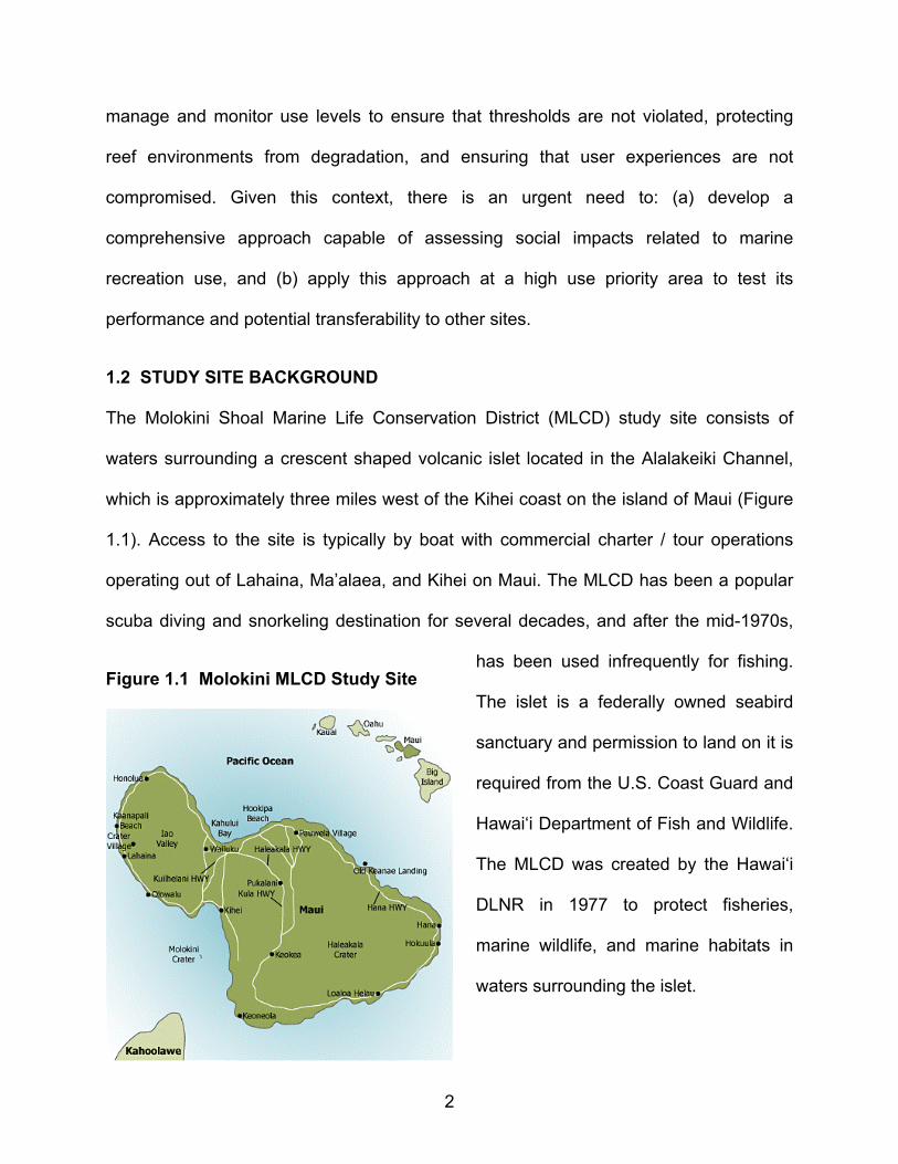
The Molokini Shoal Marine Life Conservation District (MLCD) study site consists of
waters surrounding a crescent shaped volcanic islet located in the Alalakeiki Channel,
which is approximately three miles west of the Kihei coast on the island of Maui (Figure
1.1). Access to the site is typically by boat with commercial charter / tour operations
operating out of Lahaina, Ma’alaea, and Kihei on Maui. The MLCD has been a popular
scuba diving and snorkeling destination for several decades, and after the mid-1970s,
Figure 1.1 Molokini MLCD Study Site
has been used infrequently for fishing.
The islet is a federally owned seabird
sanctuary and permission to land on it is
required from the U.S. Coast Guard and
Hawai‘i Department of Fish and Wildlife.
The MLCD was created by the Hawai‘i
DLNR in 1977 to protect fisheries,
marine wildlife, and marine habitats in
waters surrounding the islet.
3
Native Hawaiian’s utilized Molokini as both a source of fish, birds, feathers, and eggs,
and traditional fishing stone sinkers and lures can still be found in the waters
surrounding the islet. The crater’s origins have been described in Hawaiian story and
chant (Severns & Fiene, 2008) with several different stories describing places on
Molokini that are associated with four major gods: Lono, Kü, Kanaloa, and Kāne. The
chant Mele a Pakaui describes how earth mother Papa gave birth to the Big Island of
Hawai‘i then crossed the Alenuihāhā Channel to create Maui. With help from the gods
Kāne and Kanaloa, Papa delivered Mololani (Molokini) and Kaho’olawe in the Alalakeiki
Channel. In another chant, Molokini is connected to the birth of nearby Kaho’olawe
whose placenta was cut by Uluhina and tossed into the sea where it became the islet of
Molokini. In ancient times, parents who wanted a newborn son to be a seafarer placed
his placenta into the waters of the Kealaikahiki Channel between Kaho’olawe and
Molokini. This channel is significant because Kealaikahiki means ‘the path to Kahiki,”
which is better known as Tahiti. Another story of Molokini describes a love triangle that
angered the goddess Pele. The focus of this story was the lizard girl Pu’uoinaina who
jumped into the ocean off Kaho’olawe to escape Pele, but she was captured and had
her body cut in half with the lizard head forming Molokini and the tail Pu’uolan’i, which is
another cinder cone at Makena on Maui. The final story tells of a hill rising up on
Moloka‘i, which is destroyed by the kupua Kana who scatters it all over Hawai‘i with one
small piece falling into the adjacent Alalakeiki Channel to form Molokini.
In historic times, Molokini was charted by the French explorer Jean-Francoise de
Galoup Compte de La Perouse in 1786, and King David Kalakaua hired Baldwin and
Alexander to survey the island in 1883. A navigational light was installed on the islet in
4
1911, but was extinguished during WWII for security purposes and ultimately destroyed
by practice bombs when Molokini was used for target practice during this period.
Although Molokini did not suffer as much damage as nearby Kaho’olawe, the U.S. Navy
detonated two large unexploded bombs that remained inside the crater after cessation
of military activities. This pulverizing of a large area of coral reef and damage from this
event can still be seen today in the crater. Public outcry over the handling of unexploded
munitions at Molokini persuaded the Navy to finally remove most remaining WWII-era
bombs from the crater. A wooden light tower was erected on Molokini after WWII, which
lasted 42 years before it was destroyed by a storm; this was replaced by a stainless
steel tower that is still standing and regularly serviced by the U.S. Coast Guard.
Figure 1.2 Molokini Shoal MLCD
Commercial recreation use of Molokini
is known to have begun in 1974 with
afternoon catamaran rides to the site
from Ma’alaea harbor, and business
operators subsequently received
permission to bring scuba divers to the
area. During these early days of
commercial recreation activity at
Molokini, operators would use steel anchors to moor vessels at the site, but concerns
over anchor-induced damage to coral reefs eventually led to installation of 26 mooring
buoys at the site. Recreation use at Molokini has increased dramatically since
installation of these moorings, which can be used multiple times per day. Up to 30
5
vessels visit Molokini in each 24 hour period and as many as 2,180 people could visit
the site in a single day if all permitted vessels were present (Figure 1.2). Visitation at
Molokini has been estimated at 400,000 people per year and annual revenue from
activities associated with the permitted vessels has been estimated at $20 million to $36
million (Friedlander et al., 2005; Markrich, 2004).
Increasing regulation of commercial activities at Molokini for the protection of biological,
recreational, and economic resources has been necessary as visitation has increased.
Rules for the Molokini Shoal MLCD prohibit fishing, fish feeding, and any form of
collecting, anchoring, or using commercial moorings without a permit. The DLNR also
mandated a limit on the number of vessels operating at Molokini in 1994 and permits
were granted to operators who could prove that they had visited the site at least eight
times during the previous year. Permits were capped at a total of 42 and operators are
charged $50 for two-year mooring buoy access. In addition, 2% of revenue is charged
to commercial operators by the Division of Boating and Recreation (DOBOR) as a
license fee. There are currently no other agency fees required to enter Molokini.
1.3 CONCEPTUAL BACKGROUND OF RECREATION MANAGEMENT STUDIES
Many studies have empirically demonstrated that recreation activities such as
snorkeling and scuba diving can cause environmental damage to coral reefs and related
coastal resources (e.g., Barker & Roberts, 2004; Dinsdale & Harriott, 2004; Hawkins et
al., 1999; Kay & Liddle, 1989; Liddle & Kay, 1986; Lynch et al., 2004; Rodgers & Cox,
2003; Tratalos & Austin, 2001). Schleyer and Tomalin (2000), for example, found that a
use level of approximately 9,000 annual dives at a South African reef site damaged
10% of the coral. In Hawai‘i, Rodgers and Cox (2003) estimated that 200,000 visitors
6
caused a 100% coral mortality rate in both Kane’ohe and Kahalu’u Bays. This study
also showed a pattern of decreasing fish abundance with increasing scuba diving and
snorkeling use. Over a one-year period, Tissot and Hallacher (2000) found that high use
levels of scuba diving at Kealakekua Bay increased the potential for trampling and
deleterious environmental consequences such as coral breakage. These studies
suggest that marine and coastal areas may possess inherent numerical and behavioral
thresholds where recreation use simply overwhelms the biological capacity of resources
supporting these activities. The issue of how much use can be accommodated without
deteriorating user experiences and threatening the preservation or conservation of
natural areas has conventionally been addressed under the rubric of “carrying capacity.”
Recreation carrying capacity is the amount of use that an area can support and still offer
quality recreation experiences based on social, ecological, and managerial attributes. In
other words, it attempts to address “how much use is too much” (Manning, 1999).
Previous recreation studies in Hawai‘i have focused largely on environmental carrying
capacity, or the level that biophysical resources are significantly impacted by human
use. The Rogers and Cox (2003) study that showed 200,000 visitors caused 100% coral
mortality is one of several studies illustrating attempts to measure an environmental
carrying capacity of marine recreation areas in Hawai‘i. Environmental carrying capacity
is, however, difficult to measure because it is influenced by factors such as weather, site
characteristics, type of use, time and duration of use, and species composition (Cole,
1992). It is also recognized and accepted in the tourism and recreation literature that
this resource-oriented view must be augmented by consideration of other critical issues.
Shelby and Heberlein (1986), for example, described two additional types of capacity:
7
(a) social carrying capacity, or the level of use beyond which social impacts and
experiences such as crowding and user conflict are unacceptable; and (b) facility or
managerial carrying capacity, which is the amount and type of facilities and
management presence acceptable for accommodating a given use level. Most studies
in Hawai‘i have focused on environmental carrying capacities and largely ignored social
and facility capacities. This oversight is problematic because management actions such
as use limits or quotas that are designed to alleviate environmental impacts such as
coral breakage may not address social problems such as crowding and user conflict.
The concept of recreation carrying capacity has received considerable attention in the
literature (see Manning, 1999; Needham & Rollins, 2005; Needham et al., 2004; Shelby
& Heberlein, 1986 for reviews), but efforts to apply the concept in natural resource
settings have often resulted in frustration. The term “carrying capacity” implies that it is
possible to identify a single number that represents a threshold where human use of a
resource overwhelms the ability of the resource to sustain itself. Unfortunately, several
types of carrying capacity exist (e.g., social, environmental, facility) and numerous
indicators can be used to measure each type of capacity. Social carrying capacity, for
example, consists of multiple indicators such as encounters, crowding, conflict, noise,
and satisfaction. Environmental carrying capacity indicators may include coral
breakage, trampling, fish abundance, and water quality. Measuring all of these
indicators would be expensive and time consuming, and each indicator would yield a
different capacity number on scales that are not compatible or comparable. Calculating
a single recreation capacity number is, therefore, neither feasible nor realistic.
8
There are also additional difficulties in attempting to apply the carrying capacity concept.
For example, carrying capacity has often been misapplied to set visitor numbers without
considering how these numbers meet management objectives. In addition, a capacity
number can sometimes be changed in response to political pressures without
considering relevant stakeholders or other interest groups (e.g., visitors, local
communities, private operators, cultural groups). Carrying capacity numbers are often
too simplistic, based on arbitrary judgments, and fail to minimize impacts. The concept
tends to overemphasize the importance of "amount" of use and fails to consider other
important factors such as type of use, behavior of users, and cultural capacity issues
that are particularly important in Hawai‘i. Finally, by focusing on amount of use, carrying
capacity numbers imply use limits if they are exceeded, which draws attention away
from a range of other strategies that may be available to managers such as temporal
and / or spatial zoning and education. Use limits are also: (a) controversial and heavy-
handed because they may unnecessarily restrict user freedom; (b) difficult and
expensive to implement; and (c) perceived as a threat to generating tourism income,
thus causing a lack of interest group or stakeholder “buy in” (Farrell & Marion, 2002).
Recreation almost always causes social and environmental impacts, but descriptive
scientific studies that attempt to identify a cause and effect relationship between human
use and impact typically fail to provide clear guidance on where and when use
thresholds are exceeded. These studies are technically challenging and impose
substantial data collection, and their outputs do not provide any guarantee of better
management decisions or reduced impacts. It is important to recognize that some
impact and change is inevitable, and at some point the amount, nature, and type of
9
change becomes unacceptable. The critical question, therefore, is not “how much use is
too much,” but more importantly “how much impact or change is acceptable or should
be allowed” (Manning, 1999, 2004).
To overcome difficulties associated with carrying capacities, recreation researchers
have turned to contemporary planning and management frameworks that have proven
useful in addressing this question of “how much impact is acceptable” (see Manning,
2004 for a review). Frameworks such as Limits of Acceptable Change (LAC, Stankey et
al., 1985), Visitor Experience and Resource Protection (VERP, Manning, 2001), and
Visitor Impact Management (VIM, Graefe et al., 1990) combine planning and scientific
approaches to provide a sophisticated and systematic process for evaluating and
managing conditions in recreation and tourism settings. Common themes stressed in
these frameworks include: (a) input from multiple interest groups or stakeholders; (b)
focus on management of recreation impacts; (c) establishment of clear and measurable
objectives for a site; (d) collection of both physical and social science data that is linked
to these objectives; (e) definition of recreation opportunities comprised of natural, social,
and managerial conditions; (f) linkages among activities, settings, experiences, and
benefits; (g) implementation of a range of management strategies; and (h) monitoring
and evaluation. Another important aspect of these frameworks involves quantitatively
measuring select social, facility, and resource indictors at specific sites, and using these
indicators to reveal standards of quality or thresholds where indicator conditions
become unacceptable (Manning, 1999). These indicators are subsequently monitored
by field personnel to ensure that standards are maintained, and if violated, the
10
application of acceptable management actions may be imposed (e.g., zoning,
education, fees, quotas that limit use).
A second important component of these frameworks is the inclusion of input from
multiple interest groups or stakeholders. Although managers are responsible for
ensuring that standards comply with jurisdictional and regulatory mandates and
objectives, understanding how users and other stakeholders perceive impacts and how
this influences their behavior is crucial if agencies are to make effective management
decisions (Shelby & Shindler, 1992). If standards are similar among individuals,
managers may be able to condense the number of groups that they need to consider,
thus making complicated decisions simpler. If differences are exposed, then these
conflicting views among stakeholders must be addressed during the development of
appropriate managerial responses (Needham & Rollins, 2005). All of these frameworks
necessitate multi-stakeholder input to inform carrying capacity related decisions (Shelby
& Shindler, 1992) and provide a strong basis for recreation and tourism planning. These
frameworks also offer a proven tool for managers to understand the extent that indicator
impacts are acceptable or unacceptable, identify the importance of indicators, and
describe the amount of consensus among stakeholders regarding acceptable indicator
conditions (McCool & Cole, 1997; Needham et al., 2005; Shelby et al., 1992). This
approach provides a conceptual basis for addressing tradeoffs that are inherent in
recreation and tourism, a structured process within which values are explicitly
considered and presented, and a context for development of transparent and
defendable plans that are derived from and linked to clear objectives and empirical data
(Manning, 2004). In addition, these frameworks emphasize consideration of desired
11
future outcomes, and the inclusion of monitoring ensures that managers are explicitly
aware of changing resource and experiential conditions, which enhances the capability
of managing agencies to respond to changing conditions.
1.4 PROJECT OBJECTIVES
This project was funded as a Hawai‘i Recreation Impacts to Reefs – Local Action
Strategy (RIR-LAS) initiative that represents a locally driven roadmap for collaboration
and cooperative action among governmental and non-governmental partners to reduce
threats to coral reef resources (RIR-LAS, 2008). The overall goal of Hawaii’s RIR-LAS is
to determine impacts of marine recreation and tourism activities on Hawaii's coral reef
ecosystems and develop innovative management techniques that increase the
sustainability of those activities. Specific objectives include:
1. improving understanding of links between marine recreation and reef ecosystem
health, and providing a scientific basis for management decisions;
2. implementing management tools such as regulations and infrastructure to
support a reef's carrying capacity or control user behavior at various sites; and
3. increasing awareness and engaging stakeholders in reef education, monitoring,
and stewardship efforts.
In particular, this project specifically addresses the RIR-LAS management objective
related to carrying capacity, and will attempt to shift the emphasis and definition of
carrying capacity in Hawai‘i from “how many visits can be accommodated” in priority
marine recreation areas to “what are the desired conditions and to what extent do we
meet or exceed these standards.” This clarifies management goals by formulating
12
positive and output-oriented measures of success, and opens and exposes the process
of planning to public participation and scrutiny by explicitly emphasizing tradeoffs and
value judgments inherent in recreation management. Responsible authorities such as
the DLNR that manage marine recreation areas are also working under increasingly
difficult circumstances as a result of financial limitations, human resource issues (e.g.,
inadequate employee training; lack of skilled planners, facilitators, and technical or
scientific experts), time constraints, and data inadequacies. Given these local
conditions, this project will:
1. outline the administrative context and environmental conditions at the Molokini
Shoal MLCD using existing background information and secondary data;
2. present new rigorous scientific research conducted at the Molokini MLCD that
documents marine recreation use and social carrying capacity information which
has been largely unavailable until now;
3. provide a set of indicators that can serve as “standards of quality” to support
subsequent planning and management initiatives at Molokini; and
4. provide an example of how human use and social carrying capacity information
can be collected to support the management of marine recreation and tourism at
other high priority sites identified by the RIR-LAS.
1.5 DATA COLLECTION
Primary data collection that documented human use and social carrying capacity
information proceeded in three phases. First, focus group meetings were conducted in
February 2009 with commercial operators and other stakeholders on Maui including
13
government agencies, native Hawaiians, recreation interest groups, and environmental
groups. Second, researchers traveled on 28 commercial trips to Molokini in March and
April 2009, and used a standardized checklist to observe and document site
characteristics. Observations were documented on four boats operating from Ma‘alaea
harbor: two large boats that carry snorkelers (typically 50 feet or more in length carrying
up to 150 snorkelers) and two smaller boats that mainly focus on scuba divers (typically
less than 30 feet in length carrying fewer than 15 scuba divers). Observations were also
conducted on a smaller dive boat operating from Lahaina harbor and a small dive boat
operating from the Kihei boat ramp. Third, pre-trip and post-trip onsite surveys were
administered to people visiting Molokini on these tour boats in both high use (spring
break March 2009) and lower use (April 2009) periods. These surveys included
questions on a range of topics including prior visitation, activity groups, satisfaction,
encounters, crowding, conflict, value orientations, support of management, and
demographic characteristics. Pre-trip surveys were completed at the harbor or boat
ramp prior to leaving for Molokini and post-trip surveys were completed when returning
to the harbor or boat ramp.