1991 prospecting program of robert a michon · 1991 prospecting program of robert a. michon january...
TRANSCRIPT
42F13SWO009 OP91-718 MUNGO PARK POINT 010
1991 PROSPECTING PROGRAM
OF
ROBERT A. MICHON
January 28,1991 Manitouwadge, Ontario
Robert Reukl Consulting Geologist

LOCATION MAP
1991 OPAP PROSPECTING

PROSPECTING AREA #1 - NORTHWIND LAKE TO EAST BAY
LocationThe area examined is located in the Thunder Bay Mining Division
approximately 105 miles northeast of Thunder Bay in northwestern Ontario. More precisely the area is located 15 miles northnorthwest of the town of Beardmore and is best accessed by floatplane to Northwind Lake located on the east side of the prospecting area. This requires a flight of approximately 50 miles from Geraldton, the nearest float base. Secondary access can be had to the northeast end of Northwind Lake via highway 801 north from Nezah,16 miles east of Beardmore, then connecting to timber access roads.
The prospecting area lies in the southest corner of NTS map 52 H16, and can be found on the Barbara Township mining claim map, number G-92 (see map attached).
Prospecting TargetThe area prospected lies just to the northwest of the Beardmore-Geraldton
Gold Camp but seems to have been largely ignored in favor of more easily accessed areas and more favorable rock types and structures. This prolific gold camp sustained production from 1934 to 1968, producing 4,115,000 ounces of gold and 318,500 ounces of silver. A recent discovery made on the Brookbank property east of the prospecting area in central Irwin Township is reported to host 2,000,000 tons at 0.2 ounces gold per ton. Copper, lead, zinc, nickel and tungsten have all been noted to occur in the region.
Suggestions for prospecting from Gerry White, MNDM Staff Geologist Beardmore-Geraldton District, included concentrating along volcanic-intrusive contacts in an attempt to uncover "shear or tension-hosted mineralization", which has been the source of many gold deposits in the area (D.U. Kresz, 1989).
Geology and MineralizationThe bedrock geology of the area prospected consists of Precambrian
metavolcanic and intrusive rocks of die eastern Wabigoon Subprovince within the Superior structural province. These rocks consist of massive and pillowed basaltic flows and related gabbro intrusives, and more felsic volcanic rocks represented by extensive flows and pyroclastics of intermediate to felsic composition. These rocks are surrounded to the north and east by the felsic to intermediate plutonic rocks of the Northwind Lake Pluton (see map attached).
Gold mineralization to the southeast has been classified as: 1) quartz veins in both shear zones and tension fractures, and 2) shear zones mineralized with with sulphides. Gold deposits have been known to be closely associated with: 1) pretectonic rocks of intermediate composition, 2) major east-trending faults (shear zones), 3) tight folds, 4) topograpphic lineaments, and 5) zones of pervasive metamorphism.

Results of Prospecting ProgramAlthough many traverses were conducted to cover the target area,
particularly in the area of the Northwind River, no zones of faulting or mineralization were uncovered. No chemical alteration was noted in the predominantly pillowed volcanics and the mineralization noted was limited to finely disseminated pyrite locally visible. No assays of any consequence were attained. Further work in the area should be aimed to the area south of the target area where zones of shearing and rocks of a more felsic composition might be uncovered.

7cj
LECENDilANUOZtlH
fEMOZOH
QIM1K*N\IIY
rillSllH EHE AND BECEHT
UMCOMFomnnr
HIDM.L 10 iJkTC rnomozoic MAFH iKimusnrc HOCKS
wmusnr coMiAcrAKTIIEAM
ftlSH: AM. IMTEI1MKDIATC M.inoHH BOCKS
Numn HIND ijikK n.inuN
MMVSIVC CXW/ACI
EAIII.t i.lltNITIf IMTKUSIONS
lax
4o GAOro. cofta lo xfy coana4c Gaet.0. UUCOOMC4d Gabtao
**w ^sfr)m*v*V **"""J -"' I-* 4ah-\ -j\ ~~~ - l ,*' -X*
' X 7 /*tty——~~7cik
l 7ejk. "
T
7c
- \
^^Wlfc gS|^^4fe
^ v *. ^ .r-^l^liSifv^fCa., ^/h ;^^C'^^w^^^^ ^e?^]. r^^^ i^r,3a V\2^^A --"n^^C.^ iC^i. N .. ,-v
?2ci? J \ ^v x .fcfe/T^'i;*N ' X. \ ^^vi-2b;; XN N
^\"l?t^^^^} "iv"i^^,-^Sv ̂ ^^S; T \KsT x v81 ^rg, ^ji^^^^'^
^'xX \ \- kb i!2b N9v /-**^ N^v Vi* V———^X \ \ ^^r*^" ^ ^^ \\ X \ \ ^^^ ^ srv
: \ \ \ \
i /*b .:\ V-.Aj f ^|...\ V: \
\ " * \ V ^* * 1
, J V
fe
no outcrop
s \
Scale: 1:20000
Metres 500 1 Kilometre
Mile 1/4 V2 Mile
: ' /'iiA1 f l' i
••O*X^-..
^—Ontario
Ministry ofNorthern Developmentand Mines
Mines andMineralsDivision
Ontario Geological SurveyMap 2536
PRFPAMRRIAN GEOIX)GY

MUNGO PARK POINT
MN R ADMINISTRATIVE DISTRICT
NIPIGONMINING DIVISION
THUNDER BAYLAND TITLES/ REGISTRY DIVISION
THUNDER BAY
Ministry ofNaturalResources
Land
Management
Branch
G-92
MEADER
BARBA
TWR
SCALE: 1 INCH ~ 40 CHAINS
SANDRA TWP.DOROTHEA TOWNSHIP

l l
ll
l l
l l


T
Kief
C—V
V
^ - \ *s v
3 4-- -f
Ale.

. 1 i 81 c\

o- ofio\J
1 " Vr A
. V A .
4
\/
t/J31-
1
i i
i i

1 1
1 1
1 1
-•o -
C t"
4 i
*
XI
N
V
N
\
S
\
t
r -Q 0 -o
\

rv-p^L*—t ' ^'/o
W

r\
trs
t
A/

29-1 B.M.(P) 0.00 ND
0.00 ND
0.01 0.02 0.00 ND 0.03
0.00 0.00 0.00 ND 0.00
0.01 0.00 0.00 ND 0.00
0.00 0.00 0.00 ND 0.00
- 7 0.00 0.00 0.00 ND 0.00

PROSPECTING AREA #2 - DICKISON LAKE AREA
LocationThe area prospected is located in the Thunder Bay Mining Division
approximately 100 miles northeast of Thunder Bay in northwestern Ontario. More precisely the area is located 25 miles north of the town of Schrieber and can be reached via logging access roads either north from the town of Terrace Bay or south from Bankfield, a smalll community about 5 miles west of the Geraldton turn off.
The area lies in the northeast corner of NTS map 42 E3 and can be found on die Dickison Lake Area claim map.
Prospecting TargetThe targets prospected in the area consisted of sulphide occurences along
the northern granite-paragneiss contact and the contact between the paragneiss and the biotite schist-granite gneiss. There are also mineralized tension fractures along the regional fault which occurs in granite at the granite-paragneiss contact, and in the numerous quartz veins in the area. These veins range from a few feet up to 90 feet in width generally, but are known to measure up to 300 feet across (Bartley, 1955).
Geology and MineralizationHie bedrock geology in the Dickison Lake area is comprised of rocks of
Precambrian age. These rocks consist of metamorphosed sediments and paragneisses classed as Couchiching Type; granite, granite gneiss and pegmatite presumed to be Algoman in age; and diabase dikes and minor sills of Keweenawan age. The paragneisses remain as a remnant of a former larger belt of sedimentary rocks and are enclosed by the granites which comprisemost of the bedrock in the area.
Interesting sulphide mineralization has been noted around Dickison Lake and westward. Sulphide mineralization, mainly pyrite, occurs in large tension fractures in the cliffs along the south side of the regional fault valley south of Spine Creek and Spine Lake. Galena, sphalerite and chalcopyrite are found in numerous locations within the sediments in association with alteration consisting of brown weathering carbonate, biotite, sodic feldspar and quartz. Of interest also are the quartz veins noted above.
Results of the Prospecting ProgramThe traverses conducted across the metasediments and paragneiss gave a
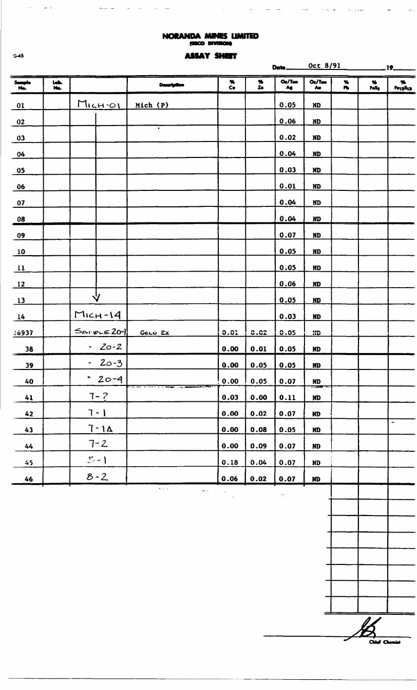
good cross-section of the geology which appears to be very interesting and merit further work to conduct a thorough sampling program. Of particular interest were the zones of sericitic and carbonate alteration which were usually accompanied by anomalous metal values. Values of up to G.2% Cu, 0.1 % Zn and

0.1 oz Ag indicate there is metal in the system and the area would be a candidate for an extensive wholerock sampling program to establish geochemical signatures for the alteration present and the host rocks and establish a database from which to proceed further.


•\5^C
NORANDA MINES LIMITED
G-*5 ASSAY SHOTTOct 8/91 .19.
N*.
01
02
03
04
05
06
07
08
09
10
11
12
13
14
26937
38
39
40
41
42
43
44
45
46
Ub.N*.
f""\ICH-O\
^ SriuiH-H•^c*.t vPi-e2O-}
- Zo-Z
- 2.0-3" Zo-4
1-7
"I- l
1-\L1-2.
Z ' \a-z
*-
Mich (P)
Gcco Ex
% Cm
O.C1
0.00
0.00
0.00
0.03
0.00
0.00
0.00
0.18
0.06
it l*
n rtiW . W4.
0.01
0.05
0.05
0.00
0.02
0.08
0.09
0.04
0.02
Ox/Ton A*
0.05
0.06
0.02
0.04
0.03
0.01
0.04
0.04
0.07
0.05
0.05
0.06
0.05
0.03
0.05
0.05
0.05
0.07
0.11
0.07
0.05
0.07
0.07
0.07
Ot/ToaA*
ND
ND
ND
ND
ND
ND
ND
ND
ND
ND
ND
ND
ND
ND
ED
ND
ND
ND
ND
ND
ND
ND
% ffc
ND j
ND
*t Mt
KfeitSia
~

DICKISON LAKE - DAILY LOG
May 19,1991Went east on Kimberly Clade road, north of Terrace Bay. Took samples
from Mo showing, l 1/2 miles west of Chorus Lake.Samples: 19-1,19-2
May 20,1991Prospected along Flag Lake and Kamuck Lake. Found only small amounts
of pyrite in quartz and rusty brown sandy soil.
Samples: 20-1, 20-2, 20-3,2O4
May 24,1991Went on to side road off the K-C road, but road washed out Continued to
prospect in the Camuck Lake area.No samples taken.
May 25,1991Prospected in the Kamuck Lake area. No samples taken.
Sept. 7,1991Rew into Greenhedge Lake with R. Reukl. Set up camp and prospected
north to Gravel River faultSamples: 7-?, 7-1,7-1A
Sept. 8,1991Prospected northwest of Greenhedge Lake. Samples: 8-1, 8-2
.x, Sept. 9,1991( Could not fly out due to weather conditions.b

ROCK SAMPLE DESCRIPTIONS
Sampled By: R.A. MichonLocation: Dickson Lake area, NW of Schrieber, Thunder Bay Mining DivisionDate(s): May 20,1991, Sept 7&S, 1991
Sample # Description20-1 Quartzvein, "bull white", with minor py and host rock inclusions20-2 As above20-3 As above20-4 Light brown silty sand7-? Sheared intermediate volvanic (andesite), quartz eyes, sericitic,
1-236 m gr py, rusty 7-1 As above, 1-39& py-cpy7-1A As above, boudinaged quartz veinlets, t-3% py-cpy8-1 Shear zove, chloritic, sericitic, quartz veilets, l-2*Xi cpy8-2 Foliated andesite, cbl filled fractures, l-2% cpy

PROSPECTING AREA #3 - NAGUNAGISIC LAKE
LocationThe prospected area is located in the Thunder Bay Mining Division
approximately 95 miles northeast of Thunder Bay in northwestern Ontario. More precisely the area is located 25 miles northwest of Schrieber and can only be accessed by floatplane to Nagunagisic Lake from the Pays Plat area immediately to the south.
The prospected area is situated near the south-central boundary of NTS map 42 E4 and can be found on the Gravel River claim map, number G-45 (see map attached).
Prospecting TargetThe prospecting target is high-quality amethyst which was first found in
the area in 1973. In the Report of Activities 1990 Resident Geologists, Bemie Schnieders, MNDM Resident Geologist Hemlo-Schrieber Area wrote "recent property examinations by the authours in the Nagunagisic Lake-Cavers Lake area indicated the presence of high-quality amethyst occurences. Further prospecting and exploration is warranted and recommended, even though these areas remain remote and acccess is difficult". Extensions of the known showings and the uncovering of new showings are the purpose of prospecting in this area.
GeologyThe amethyst occurs in breccia zones in pink granite and migmatite of
archean age. The amethyst is found in vuggy breccia zones and consists of an interconnected system of veins that enclose angular fragments of the granitic rocks. Numerous cavities and vugs may be found and may be up to several feet in diameter. The vein material may consist of an outer, border zone and central zone of amethyst Well-formed pyramid shaped crystals may line the cavities, with beautiful deep purple crystals sometimes found. In places the amethyst may be stained a deep red colour by hematite.
Results of the Prospecting ProgramThe prospecting was successful in extendeing the known breccia zone
system west of claim number TB 350313 with quarts filled fractures and brecciated granite noted in the prospecting. However no extentions to the fracture system noted in front of the camp was seen south of claim TB 350313. The area continues to have excellent potential for further discoveries of amethyst
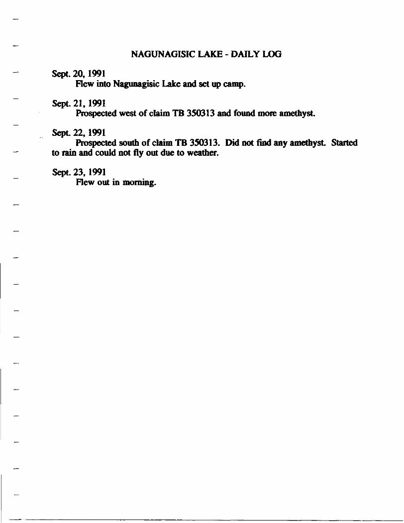
NAGUNAGISIC LAKE - DAILY LOG
Sept. 20,1991Flew into Nagunagisic Lake and set up camp.
Sept. 21,1991Prospected west of claim TB 350313 and found more amethyst
Sept 22,1991Prospected south of claim TB 350313. Did not find any amethyst Started
to rain and could not fly out due to weather.
Sept. 23,1991Flew out in morning.

/'l
GRAVEL RIVERmM.lt. AMMMTMTIVE tISTNICT
NIPIGON free**ceMINING IIVISIM S A f"
THUNDER BAYLAND TITUS/ Mcisim DIVISION
THUNDER BAY6*'
MC47*lMZ47C|r--}- — i i
SCALE: 11NCH - 40 CHAINS
49*00'
"45
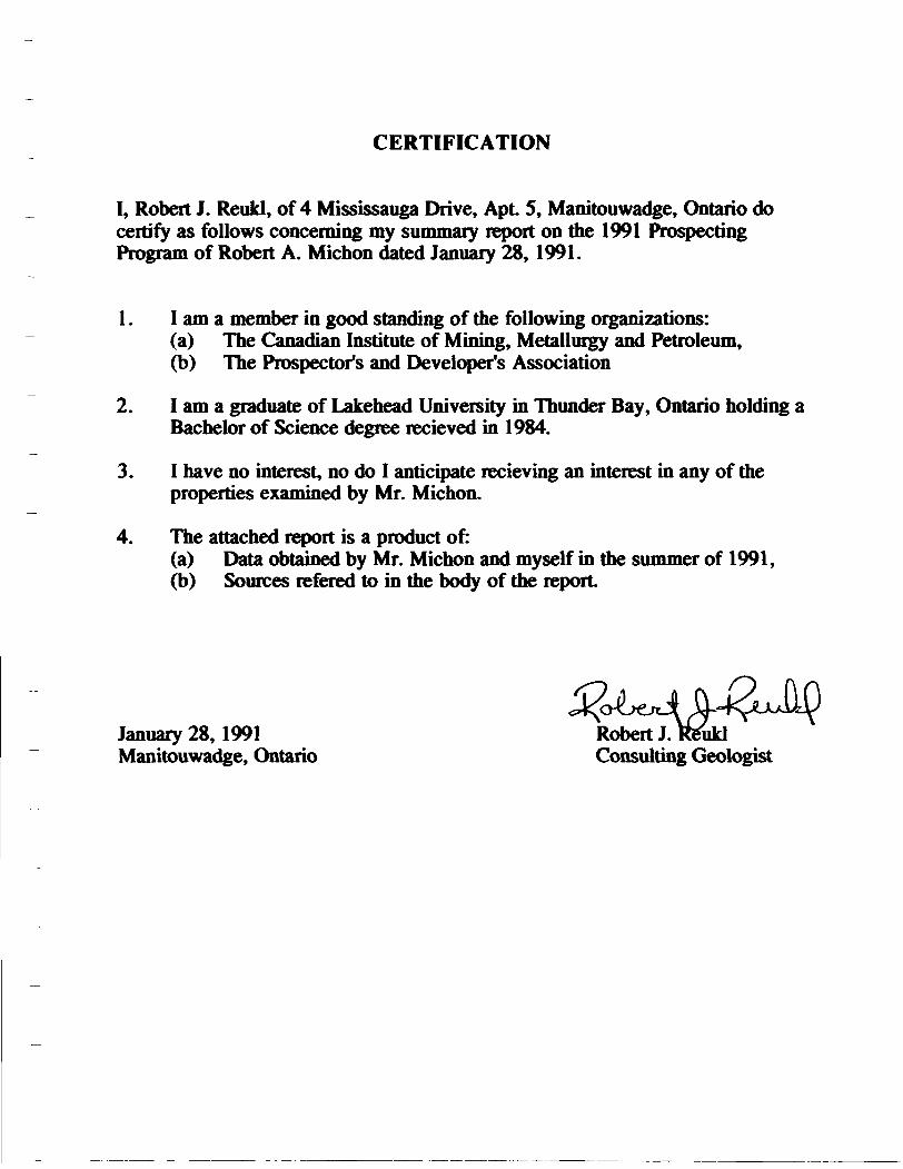
CERTIFICATION
I, Robert J. Reukl, of 4 Mississauga Drive, Apt 5, Manitouwadge, Ontario do certify as follows concerning my summary report on the 1991 Prospecting Program of Robert A. Michon dated January 28, 1991.
1. I am a member in good standing of the following organizations:(a) The Canadian Institute of Mining, Metallurgy and Petroleum,(b) The Prospector's and Developer's Association
2. I am a graduate of Lakehead University in Thunder Bay, Ontario holding a Bachelor of Science degree recieved in 1984.
3. I have no interest, no do I anticipate recieving an interest in any of the properties examined by Mr. Michon.
4. The attached report is a product of:(a) Data obtained by Mr. Michon and myself in the summer of 1991,(b) Sources refered to in the body of the report
January 28,1991 Robert J. Reukl Manitouwadge, Ontario Consulting Geologist