0547 trip report - maine.gov · weather conditions (week 2): rain showers; low-to-mid 40s °f (15...
TRANSCRIPT

TRIP REPORT FOR THE
LEEDS METAL SITE INSPECTION
LEEDS, MAINE
Prepared For: U.S. Environmental Protection Agency
Region I Office of Site Remediation and Restoration
5 Post Office Square Suite 100 (OSRR07-2)
Boston, MA 02109-3912
CONTRACT NO. EP-W-05-042
CERCLIS NO. MEN000103584 State ID No. REM00577
TDD No. 09-05-0004 TASK NO. 0547 DC NO. A-6659
Submitted By: Weston Solutions, Inc.
Region I Superfund Technical Assessment and Response Team III (START)
3 Riverside Drive Andover, MA 01810
18 March 2011

S:\09050004\Reports\Trip Report\0547_Trip_Report.docx 1 18 March 2011
EPA REGION I SUPERFUND PROGRAM TRIP REPORT/CHECKLIST
44444444444444444444444444444444444444444444444444444444444444444 Inspection Information 44444444444444444444444444444444444444444444444444444444444444444 Site Name: Leeds Metal Address: Along Blue Rock Road CERCLIS No.: MEN000103584 Town: Leeds State ID No.: REM00577 State: Maine TDD No.: 09-05-0004 Date of On-Site Reconnaissance: 16 March 2010 Time of On-Site Reconnaissance: 0830 hours (hrs) to 1400 hrs Weather Conditions: Sunny; high 50s degrees Fahrenheit (°F) Dates of Sampling (Week 1): 8 November 2010 to 12 November 2010 Times of Sampling (Week 1): 1030 hrs to 2000 hrs (8 November 2010) 0730 hrs to 2000 hrs (9 November 2010) 0730 hrs to 1830 hrs (10 November 2010) 0730 hrs to 1800 hrs (11 November 2010) 0730 hrs to 1000 hrs (12 November 2010) Weather Conditions (Week 1): Rain, windy; low-to-middle (mid) 40s °F (8 November 2010) Rain; low-to-mid 40s °F (9 November 2010) Windy; low-to-mid 40s °F (10 November 2010) Sunny; mid-to-upper 40s °F (11 November 2010) Sunny; low-to-mid 50s °F (12 November 2010) Dates of Sampling (Week 2): 15 November 2010 to 19 November 2010 Times of Sampling (Week 2): 1030 hrs to 1700 hrs (15 November 2010) 0730 hrs to 1830 hrs (16 November 2010) 0730 hrs to 1730 hrs (17 November 2010) 0730 hrs to 1630 hrs (18 November 2010) 0730 hrs to 1200 hrs (19 November 2010) Weather Conditions (Week 2): Rain showers; low-to-mid 40s °F (15 November 2010) Rain showers; mid-to-upper 40s °F (16 November 2010) Rain and wind; upper 40s to mid 50s °F (17 November 2010) Cloudy; low-to-mid 40s °F (18 November 2010) Sunny; low-to-mid 30s °F (19 November 2010) Dates of Sampling (Week 3): 29 November 2010 to 2 December 2010 Times of Sampling (Week 3): 1200 hrs to 1600 hrs (29 November 2010) 0730 hrs to 1700 hrs (30 November 2010) 0730 hrs to 1730 hrs (1 December 2010) 0730 hrs to 1200 hrs (2 December 2010) Weather Conditions (Week 3): Partly cloudy; upper 30s °F (29 November 2010) Cloudy; low-to-mid 40s °F (30 November 2010) Cloudy; low-to-mid 40s °F (1 December 2010) Cloudy; low-to-mid 40s °F (2 December 2010)

44444444444444444444444444444444444444444444444444444444444444444 Inspection Information (Continued) 44444444444444444444444444444444444444444444444444444444444444444
S:\09050004\Reports\Trip Report\0547_Trip_Report.docx 2 18 March 2011
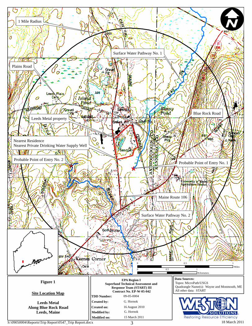
Site Status at Time of Inspection: ( ) ACTIVE (T) INACTIVE ( ) ABANDONED Comments: The Leeds Metal property is located along Blue Rock Road in Leeds, Androscoggin County, Maine (ME) (Figure 1) [1; 3-6]. The geographic coordinates of the property, as measured from its approximate center, are 44° 14′ 14.1″ north latitude and 70° 04′ 53.6″ west longitude [1-2]. The Leeds Metal property is depicted on the Town of Leeds Tax Assessor’s Map Number (No.) 4, as Lot No. 38 [5-6]. According to the Town of Leeds Tax Assessor’s office, the 36-acre property is currently owned by Guilford Transportation Industries, Inc., which was rebranded under the name of Pan AM Railways in March 2006 [5; 48]. According to previous reports, from approximately 1969 to 1984, scrap metal recovery processes were conducted on the property by various entities [53]. In addition, available file information indicates that cast concrete manufacturing took place on the northwestern portion of the property during an unspecified time period [51; 74]. As of the March 2010 reconnaissance and the November to December 2010 on-site sampling events, the eastern and southern portions of the Leeds Metal property were sparsely vegetated and contained car shredding waste both on the ground surface and in piles. A former building foundation and operations area were observed along the eastern property boundary, adjacent to railroad tracks. The northern and western portions of the property were observed to be wooded, and contained two lagoon areas and an area of concrete disposal. The property is bordered to the south by a wooded area, a wetland, and residential properties; to the west by ME Route 106 and residential properties; to the north by a former concrete manufacturing building and gravel storage area; and to the east by a railroad track and wooded area. The Leeds Metal property is located in a mixed residential/industrial area, adjacent to former industrial areas (a former concrete manufacturer and a gravel quarry) located to the north and northeast (Figure 2) [1, pp. 2-15]. During the March 2010 reconnaissance and the November to December 2010 on-site sampling event, START personnel observed the following nine source areas on and adjacent to the Leeds Metal property: Debris Pile A, located on the eastern central portion of the property, west of the concrete pad; Debris Pile B, located on the south eastern portion of the property, directly south of Debris Pile A; Debris Pile C, located on the south central portion of the property, directly west of Debris Pile B; Debris Pile D, located on the southern portion of the property, southwest of Debris Pile B; the Abandoned Drum Area, located along the southern property boundary and extending south onto Lot Number 40, depicted on the Town of Leeds, ME Tax Assessor’s Map Number 4; the Battery Drop Area, located on the northern portion of the property, adjacent to the access road and railroad; the Former Operations Area, encompassing approximately the eastern half of the property; the Concrete Storage Area, located along the northwestern property boundary, adjacent to the property depicted on the Town of Leeds, ME Tax Assessor’s Map Number 4, as Lot Number 37; and the Container Disposal Area, located along the western property boundary, adjacent Maine Route 106 (Figure 2) [1, pp 2-48; 115, pp. 2-48; 116, pp. 2-48, 117, pp. 2-9].
[[_
Figure 1
09-05-0004G. Hornok
16 August 2010Leeds Metal
Along Blue Rock RoadLeeds, Maine
Site Location Map
EPA Region I Superfund Technical Assessment and
Response Team (START) IIIContract No. EP-W-05-042
TDD Number:Created by:
Created on:Modified by:Modified on:
Topos: MicroPath/USGSQuadrangle Name(s): Wayne and Monmouth, MEAll other data: START
Data Sources:
I
0 10.5Miles
0 10.5Kilometers
Probable Point of Entry No. 2
Surface Water Pathway No. 2
Probable Point of Entry No. 1
Surface Water Pathway No. 1
Leeds Metal property
Nearest ResidenceNearest Private Drinking Water Supply Well
1 Mile Radius
Maine Route 106
Blue Rock Road
Plains Road
G. Hornok
15 March 2011S:\09050004\Reports\Trip Report\0547_Trip Report.docx 18 March 20113

!>!>
!>!>
!>!>!>!>
!>
!>
!>
Figure 2
0 100 200 300 400 500 60050Feet
I
LEGEND
Imagery: Me GIS Spring 2003 OrthoimageryAll other data: START
09-05-0004G. Hornok16 August 2010
Leeds MetalAlong Blue Rock Road
Leeds, Maine
Site Map
Data Sources:
EPA Region I Superfund Technical Assessment and
Response Team (START) IIIContract No. EP-W-05-042
TDD Number:Created by:Created on:Modified by:Modified on:
Property!> Monitoring Wells
Drum Disposal AreaDebris PilesFormer Operations AreaContainer Disposal AreaLagoonsBattery Drop AreaWetlandAccess Road
Container Disposal Area
Lagoons
Property Boundary
Debris Pile B
Debris Pile D
Debris Pile C
Debris Pile A*
Battery Drop Area
ME Route 106
Blue Rock Road
Pond
Nearest Residence andPrivate Drinking Water Supply Well
Wetland AreaSurface Water Pathway No. 1
Concrete Disposal Area
Access Road
Concrete Pad/Building
ERM-5S
Railroad Tracks
ERM-2S/2D
ERM-1S/1D
ERM-3S/3D
ERM-4S/4D
Former Operations Area
RX-2S
RX-3S
G. Hornok9 March 2011
*Debris Pile A aerial extent based on on-site observations.
On-site Wetland
S:\09050004\Reports\Trip Report\0547_Trip Report.docx 18 March 20114

S:\09050004\Reports\Trip Report\0547_Trip_Report.docx 5 18 March 2011
44444444444444444444444444444444444444444444444444444444444444444 Inspection Information (Concluded) 44444444444444444444444444444444444444444444444444444444444444444 During the March 2010 reconnaissance and the November to December 2010 on-site sampling event, START personnel observed four groundwater monitoring well couplets, as well as three single shallow wells. The groundwater monitoring well couplets contained a shallow well (designated with an “S”) and a deep well (designated with a “D”), and were located on the southern portion of the property. The shallow groundwater monitoring wells were observed on the central and northwestern portion of the property. In addition, START personnel observed an access road extending from the northern most point of the property to the southern property boundary. A pond was observed on the central portion of the property, adjacent to (north of) Debris Pile C. A concrete pad and abandoned building were observed along the eastern property boundary within the Former Operations Area. START personnel observed a wetland area located south of the Leeds Metal property (Figure 2) [1, pp 2-48; 115, pp. 2-48; 116, pp. 2-48, 117, pp. 2-9]. 44444444444444444444444444444444444444444444444444444444444444444 Personnel Performing Inspection 44444444444444444444444444444444444444444444444444444444444444444 Agency/Organization Names Program ( ) EPA Region I: Nancy Smith1 OSRR* Martha Bosworth1 OSRR ( ) EPA Region I Contractor: Gerald Hornok1, 2, 3, 4 START** John F. Kelly1, 2, 3, 4 START Timothy Benton1 START Dean D. Brammer2, 3 START Carolyn Imbres2 START Robert Sharp2, 3, 4 START Greg Parrish2, 3, 4 START Agency/Organization Names Program ( ) State: Kathy Howatt1, 3 ME DEP*** Troy Smith3 ME DEP ( ) Other: Dana Banks1, 2, 3 Pan Am Railways * U.S. Environmental Protection Agency Office of Site Remediation and Restoration (OSRR). ** Superfund Technical Assessment and Response Team III (START). *** Maine Department of Environmental Protection (ME DEP). 1 Personnel present for the 16 March 2010 On-Site Reconnaissance. 2 Personnel present for the 8 through 12 November 2010 Sampling Event. 3 Personnel present for the 15 through 19 November 2010 Sampling Event. 4 Personnel present for the 29 November 2010 through 2 December 2010 Sampling Event.

S:\09050004\Reports\Trip Report\0547_Trip_Report.docx 6 18 March 2011
44444444444444444444444444444444444444444444444444444444444444444 Site Ownership-Current Owner
44444444444444444444444444444444444444444444444444444444444444444 Name: Guilford Transportation Industries Telephone: (978) 663-1218 Pan AM Railways Address: 1700 Iron Horse Park North Billerica, MA 01862 44444444444444444444444444444444444444444444444444444444444444444 On-Site Reconnaissance Trip: Brief Chronology 44444444444444444444444444444444444444444444444444444444444444444 Details of the site visit are included in the site observations/concerns section. On-Site Reconnaissance: 16 March 2010 0830 hrs Weston Solutions, Inc. Superfund Technical Assessment and Response Team III
(START) Site Leader (SL) Mr. Gerald Hornok, START member Mr. Tim Benton, and START Project Leader (PL) Mr. John Kelly arrived at the Leeds Metal property located along Blue Rock Road in Leeds, Androscoggin County, ME to conduct a reconnaissance of the property. START members completed calibration of a MultiRAE meter with carbon monoxide (CO), hydrogen sulfide (H2S), lower explosive limit (LEL), oxygen (O2), and volatile organic compound (VOC) sensors. Background values detected on the sensors were recorded as follows: CO = 0 parts per million (ppm); H2S = 0 ppm, LEL = 0 percent (%); O2 = 20.9 ppm; and VOC = 0 ppm. In addition, START personnel performed a battery check on a Ludlum Model 19A radiation meter. The background radiation value detected on the Model 19A was 10 microRoengtens per hour (µR/hr).
0840 hrs A Pan Am Railways safety advisor arrived on site to accompany on-site
reconnaissance personnel. START Site Health and Safety Coordinator (SHSC) Kelly conducted a tailgate health and safety briefing covering site health and safety concerns, which included slips, trips, and falls as well as working around train tracks.
0850 hrs Maine Department of Environmental Protection (ME DEP) Project Manager Ms.
Kathy Howatt arrived on site to participate in the on-site reconnaissance. 0925 hrs Pan Am Railways Environmental Director, Mr. Dana Banks, arrived on site to
participate in the on-site reconnaissance. START personnel discussed with Mr. Banks the U.S. Environmental Protection Agency (US EPA) Pre-Remedial Program’s interest in the site and the anticipated plans for the on-site reconnaissance. Mr. Banks requested that any reconnaissance activities taking place around the railroad tracks be conducted with the Pan Am Railways safety advisor.
S:\09050004\Reports\Trip Report\0547_Trip_Report.docx 7 18 March 2011
44444444444444444444444444444444444444444444444444444444444444444 On-Site Reconnaissance Trip: Brief Chronology (Continued) 44444444444444444444444444444444444444444444444444444444444444444 0940 hrs On-site personnel began the reconnaissance of the northern portions of the Leeds
Metal property. 1030 hrs US EPA Site Assessment Manager (SAM) Ms. Nancy Smith and US EPA
representative Ms. Martha Bosworth arrived on site to participate in the on-site reconnaissance. START SHSC Kelly conducted a tailgate safety meeting with EPA personnel, who reviewed and signed the HASP.
1045 hrs All on-site personnel began the on-site reconnaissance of the central and eastern
portions of the property. 1315 hrs All personnel completed the on-site reconnaissance, and US EPA representatives
Ms. Smith and Ms. Bosworth, as well as ME DEP representative Ms. Howatt, departed the property. START personnel documented site features and conditions using a Global Positioning System (GPS) unit and digital camera.
1400 hrs START personnel departed the property and observed the area located east of the
property, along the downstream 15-mile surface water pathway. In addition, START personnel identified residential houses located south and southwest of the Leeds Metal property for potential drinking water sampling. In addition, START identified two houses located west of the site for potential collection of background soil/source and drinking water samples.
44444444444444444444444444444444444444444444444444444444444444444 On-Site Sampling Trips: Brief Chronology 44444444444444444444444444444444444444444444444444444444444444444 Details of the site visit are included in the site observations/concerns section. On-Site Sampling Trip (Week 1): 8 November 2010 (Monday) 1030 hrs START members Hornok, Kelly, Dean Brammer, Robert Sharp, Gregory Parrish,
and Carolyn Imbres arrived at the START staging area for the Leeds Metal property, after being rerouted due to downed trees on nearby local roads. START SHSC Kelly conducted a review of the site-specific Health and Safety Plan (HASP) and a tailgate safety briefing concerning the anticipated tasks for the day and reviewed the Site-Specific Quality Assurance Project Plan (SS-QAPP) requirements. All on-site personnel reviewed and signed the HASP.
1045 hrs START personnel conducted calibration and bump checks of air monitoring
equipment [Ibrid MX6 Combustible Gas Indicator/Oxygen (CGI/O2) meters] and water quality monitoring equipment (YSI 63 and LaMotte 2020 Turbidity Meters). In addition, START personnel established command and support areas and began decontamination of all non-dedicated sampling equipment (hand augers, bowls, scoops, spigot adaptor, etc.).

44444444444444444444444444444444444444444444444444444444444444444 On-Site Sampling Trip: Brief Chronology (Continued) 44444444444444444444444444444444444444444444444444444444444444444
S:\09050004\Reports\Trip Report\0547_Trip_Report.docx 8 18 March 2011
1215 hrs START personnel mobilized to the Dead River No. 2, located southwest of the Leeds Metal property, along Surface Water Pathway No. 2, to begin sediment sampling activities. Sediment sampling activities were conducted as follows: the most downstream sample was collected first, and subsequent samples were collected from progressively upstream locations.
1230 hrs START personnel mobilized to a residence at 94 Route 106 (Town of Leeds, ME
Tax Assessor’s Map No. 1, Lot No. 67-A) to collect drinking water sample DW-13 (A3T35/MA3T35/MA3TL5). The residence was supplied drinking water from an on-site, approximately 187-feet (ft) deep drilled bedrock private supply well. START personnel collected the sample from the kitchen sink spigot after system purging was completed and water quality parameters stabilized per START protocols. The sample was collected after water flowed through an approximately 30-gallon holding tank and the home’s piping system. A sediment filtration system was noted by START; however, according to the homeowner, the filtration system was previously bypassed and was no longer in service. Throughout the sampling event, all drinking water samples were submitted to Contract Laboratory Program (CLP) laboratories for VOCs, total metals, and dissolved metals analyses.
1242 hrs START personnel collected sediment sample SD-27 (A3T93/MA3T93) from the
most downstream sediment sampling location along the Dead River No. 2, adjacent to a wooden bridge.
1259 hrs START personnel collected sediment sample SD-26 (A3T92/MA3T92) from a
downstream location along the Dead River No. 2. 1319 hrs START personnel collected sediment sample SD-25 (A3T91/MA3T91) from the
Dead River No. 2, at its confluence with a groundwater seep. 1345 hrs START members mobilized to a residence at 23 Plains Road (Town of Leeds, ME
Tax Assessor’s Map No. 4, Lot No. 55) to collect drinking water sample DW-01 (A3T23/MA3T23/MA3TK3). The residence was supplied drinking water from an on-site, 87-ft deep drilled overburden private supply well. START personnel collected the sample from an in-line spigot utilizing a spigot adaptor, after system purging was completed and water quality parameters stabilized per START protocols. The sample was collected after water flowed through a holding tank and prior to any filtration system.
1420 hrs START personnel collected sediment sample SD-31 (A3T97/MA3T97) [Matrix
Spike/Matrix Spike Duplicate (MS/MSD)] from a downstream location along the Dead River No. 2.
1435 hrs START personnel mobilized to a residence at 86 Route 106 (Town of Leeds, ME
Tax Assessor’s Map No. 1, Lot No. 66) to collect drinking water sample DW-14 (A3T36/MA3T36/MA3TL6) and field duplicate sample DW-33

44444444444444444444444444444444444444444444444444444444444444444 On-Site Sampling Trip: Brief Chronology (Continued) 44444444444444444444444444444444444444444444444444444444444444444
S:\09050004\Reports\Trip Report\0547_Trip_Report.docx 9 18 March 2011
(A3T55/MA3T55/ MA3TN5). The residence was supplied drinking water from an on-site, 18-ft deep dug well. START personnel collected the sample from the kitchen sink spigot after system purging was completed and water quality parameters stabilized per START protocols. The sample was collected after water flowed through a holding tank and the home’s piping system. The house’s filtration system was bypassed by START for the purposes of sample collection.
1450 hrs START personnel collected sediment samples SD-21 (A3T87/MA3T87) and SD-
22 (MA3T88), from an upstream location along the Dead River No. 2, for background stream reference comparison purposes.
1510 hrs START personnel collected sediment sample SD-23 (A3T89/MA3T89) from
immediately beneath a groundwater seep along an intermittent stream, prior to the intermittent stream converging with the Dead River No. 2.
1535 hrs START personnel collected sediment samples SD-19 (A3T85/MA3T85) and SD-
20 (MA3T86) from an upstream tributary converging with the Dead River No. 2, to document reference stream sediment conditions for comparison purposes. START observed and noted that there was limited vegetation growing on the riverbed of the tributary immediately prior to discharging to the Dead River No. 2 compared to vegetation growth on the riverbed of the Dead River No. 2, at both downstream and upstream of the convergence.
1540 hrs START personnel mobilized to a residence at 13 Young’s Drive (Town of Leeds,
ME Tax Assessor’s Map No. 1, Lot No. 67-3) to collect drinking water sample DW-10 (A3T32/MA3T32/MA3TL2). The residence was supplied drinking water from an on-site 127-ft drilled gravel packed overburden private supply well. START personnel collected the sample from an outside spigot after system purging was completed and water quality parameters stabilized per START protocols. The sample was collected after water flowed through a holding tank. The water softener was bypassed by START for the purposes of sample collection. No filtration systems were present within the house.
1542 hrs START personnel mobilized to a residence at 182 Route 106 (Town of Leeds,
ME Tax Assessor’s Map No. 4, Lot No. 46) to collect drinking water sample DW-05 (A3T27/MA3T27/MA3TK7). The residence was supplied drinking water from an on-site, 26-ft deep drilled private supply well, located within a shed along the toe-slope of an embankment on the property. START collected the sample from the kitchen sink spigot, after water followed through a holding tank and the home’s piping system. At the request of the homeowner, START purged the drinking water system for only approximately five minutes. Therefore, the water quality parameters were not stabilized according to START protocols at the time of sample collection. No filtration systems existed within the house.
1645 hrs START personnel mobilized to a residence at 105 Route 106 (Town of Leeds,
ME Tax Assessor’s Map No. 4, Lot No. 39) to collect drinking water sample DW-

44444444444444444444444444444444444444444444444444444444444444444 On-Site Sampling Trip: Brief Chronology (Continued) 44444444444444444444444444444444444444444444444444444444444444444
S:\09050004\Reports\Trip Report\0547_Trip_Report.docx 10 18 March 2011
09 (A3T31/MA3T31/MA3TL1) (MS/MSD). The residence was supplied drinking water from an on-site, approximately 222-ft deep drilled bedrock private supply well. START personnel collected the sample from an inside spigot in the basement, after system purging was completed and water quality parameters stabilized per START protocols. The sample was collected prior to a holding tank and sediment filter.
1658 hrs START personnel mobilized to a residence at 67 Route 106 (Town of Leeds, ME
Tax Assessor’s Map No. 1, Lot No. 58-3) to collect drinking water sample DW-20 (A3T42/MA3T42/MA3TM2). The residence was supplied drinking water from an on-site, 16-ft deep, dug overburden private supply well. START personnel collected the sample from a basement spigot after system purging was completed and water quality parameters stabilized per START protocols. The sample was collected after water flowed through an approximately 30-gallon holding tank. The sample was collected prior to an in-line filtration system.
1748 hrs START personnel mobilized a residence at 61 Route 106 (Town of Leeds, ME
Tax Assessor’s Map No. 1, Lot No. 58-2) to collect drinking water sample DW-22 (A3T44/MA3T44/MA3TM4). The residence was supplied drinking water from an on-site dug private supply well (depth unknown). START personnel collected the sample from an inside basement spigot utilizing a spigot adapter, after system purging was completed and water quality parameters stabilized per START protocols. The sample was collected after water flowed through a holding tank. No filtration systems were known by START to exist within the house.
1754 hrs START personnel mobilized to a residence at 52 Route 106 (Town of Leeds, ME
Tax Assessor’s Map No. 1, Lot No. 63-1) to collect drinking water sample DW-25 (A3T47/MA3T47/MA3TM7). The residence was supplied drinking water from an on-site 368-ft deep drilled bedrock private supply well. START personnel collected the sample from a basement spigot after system purging was completed and water quality parameters stabilized per START protocols. The sample was collected after water flowed through an approximately 25-gallon holding tank, and prior to a filter system. According to the homeowner, the drilled well was recently installed due to problems with water yield from the former on-site dug drinking water supply well.
1800 hrs START personnel collected rinsate blank sample RB-01
(A3TA0/MA3TA0/MA3TP7) from a spigot adaptor used during drinking water collection; and collected rinsate blank sample RB-08 (A3TA7/MA3TA7) from a hand auger used during sediment sampling activities. Throughout the sampling event, rinsate blanks collected from non-dedicated equipment associated with drinking water and groundwater sampling were submitted to CLP laboratories for VOC, dissolved metals, and total metals analyses. Rinsate blank samples collected from non-dedicated equipment associated with source/soil and sediment

44444444444444444444444444444444444444444444444444444444444444444 On-Site Sampling Trip: Brief Chronology (Continued) 44444444444444444444444444444444444444444444444444444444444444444
S:\09050004\Reports\Trip Report\0547_Trip_Report.docx 11 18 March 2011
sampling were submitted to CLP laboratories for VOC, polychlorinated biphenyls (PCB), and total metals analyses.
1835 hrs START personnel mobilized to a residence at 91 Route 106 (Town of Leeds, ME
Tax Assessor’s Map No. 1, Lot No. 58-7) to collect drinking water sample DW-16 (A3T38/MA3T38/MA3TL8). The residence was supplied drinking water from an on-site 198-ft deep drilled bedrock private supply well. START personnel collected the sample from an inside basement spigot after system purging was completed and water quality parameters stabilized per START protocols. The sample was collected after water flowed through a holding tank. No filtration or water softener systems were observed in the house.
1920 hrs START personnel mobilized to a residence at 11 Route 106 (Town of Leeds, ME
Tax Assessor’s Map No. 1, Lot No. 59) to collect drinking water sample DW-30 (A3T52/MA3T52/MA3TN2). The residence was supplied drinking water from an on-site drilled private supply well [well depth and formation characteristics (i.e. overburden/bedrock) are unknown]. START personnel collected the sample from an in-line spigot in the basement, immediately after water entered the home’s piping system. The sample was collected prior to a holding tank, after system purging was completed and water quality parameters stabilized per START protocols. The homeowner stated that he had bypassed the filtration systems and water softeners located in the basement. PL Kelly also noted that the homeowner performed automotive repairs and auto painting/finishing on the property and in the basement area.
2000 hrs START personnel secured all samples and departed the command post area for
the day. On-Site Sampling Trip (Week 1): 9 November 2010 (Tuesday) 0730 hrs START personnel arrived at the staging area for the Leeds Metal property.
START SHSC Kelly conducted a review of the HASP and a tailgate safety briefing concerning the anticipated tasks for the day, and reviewed the SS-QAPP requirements for sampling. All on-site personnel reviewed and signed the HASP/tailgate meeting attendance sheet. Pan Am Railways personnel were on site to observe sampling activities.
0830 hrs START personnel conducted calibration and bump checks of water quality
monitoring equipment. In addition, START personnel decontaminated all non-dedicated sampling equipment (hand augers, bowls, scoops, spigot adaptor, etc.).
0900 hrs START members performed groundwater elevation measurements on previously
identified groundwater monitoring wells on the Leeds Metal property. START personnel also surveyed two newly observed groundwater monitoring wells (RX-2S and RX-3S), which were installed as part of the Roux Associates, Inc. (Roux)

44444444444444444444444444444444444444444444444444444444444444444 On-Site Sampling Trip: Brief Chronology (Continued) 44444444444444444444444444444444444444444444444444444444444444444
S:\09050004\Reports\Trip Report\0547_Trip_Report.docx 12 18 March 2011
Environmental Investigation of the Concrete Disposal Area on the northwestern portion of the property.
0950 hrs START personnel collected sediment sample SD-09 (A3T75/MA3T75) from the
southern lagoon located on the northwestern portion of the Leeds Metal property. 1025 hrs START personnel collected sediment sample SD-07 (A3T73/MA3T73) from a
location adjacent to an abandoned 55-gallon steel drum, within the southern lagoon located on the northwestern portion of the Leeds Metal property.
1105 hrs START personnel collected sediment sample SD-08 (A3T74/MA3T74) from the
northern lagoon located on the northwestern portion of the Leeds Metal property. 1130 hrs START personnel collected sediment sample SD-05 (A3T71/MA3T71)
(MS/MSD) from the wetland located on the northwestern portion of the Leeds Metal property.
1135 hrs START personnel collected sediment samples SD-30 (A3T96/MA3T96) from the
wetland located on the northwestern portion of the Leeds Metal property. 1204 hrs START personnel collected sediment samples SD-06 (A3T72/MA3T72) from the
wetland located on the northwestern portion of the Leeds Metal property. 1225 hrs START personnel mobilized to a residence at 60 Route 106 (Town of Leeds, ME
Tax Assessor’s Map No. 1, Lot No. 63-2) to collect drinking water sample DW-24 (A3T46/MA3T46/MA3TM6). The residence was supplied drinking water from an on-site, approximately 375- to 400-ft deep, drilled bedrock private supply well. START personnel collected the sample from an outdoor spigot after system purging was completed and water quality parameters stabilized per START protocols. The sample was collected after water flowed through a 40-gallon holding tank and the home’s piping system. According to the homeowner, the house had a water softener system; however, the system was bypassed for sample collection purposes.
1240 hrs START personnel collected sediment sample SD-10 (A3T76/MA3T76) and field
duplicate sample SD-32 (A3T98/MA3T98) from the eastern side of the on-site pond located in the central portion of the Leeds Metal property.
1355 hrs START personnel collected surface soil/source sample SS-26 (A3SX4/MA3SX4)
at 0-18 inches below ground surface (bgs) from the Former Operations Area of the Leeds Metal property. The sample was collected approximately 10 feet northwest of the bottom toe-slope of Debris Pile D. Simultaneously, START personnel also collected surface soil/source sample SS-28 (A3SX6/MA3SX6) at 6-15 inches bgs from the eastern slope of Debris Pile D.

44444444444444444444444444444444444444444444444444444444444444444 On-Site Sampling Trip: Brief Chronology (Continued) 44444444444444444444444444444444444444444444444444444444444444444
S:\09050004\Reports\Trip Report\0547_Trip_Report.docx 13 18 March 2011
1357 hrs START personnel collected surface soil/source sample SS-25 (A3SX3/MA3SX3) at 6-18 inches bgs from the Former Operations Area. The sample was collected approximately 20 feet northwest of the bottom toe-slope of Debris Pile D, within a slight depression.
1400 hrs START personnel collected surface soil/source sample SS-29 (A3SX7/MA3SX7)
at 12-24 inches bgs from the southern slope of Debris Pile D. 1403 hrs START personnel collected surface soil/source sample SS-31 (A3SX9/MA3SX9)
(MS/MSD) at 12-24 inches bgs from the northern slope of Debris Pile D. 1405 hrs START personnel collected surface soil/source sample SS-30 (A3SX8/MA3SX8)
at 0-24 inches bgs from the western slope of Debris Pile D. 1425 hrs START personnel collected subsurface soil/source sample SB-28
(A3T08/MA3T08) at 24-36 inches bgs from the eastern slope of Debris Pile D. 1430 hrs START personnel collected subsurface soil/source sample SB-29
(A3T09/MA3T09) at 30-42 inches bgs from the southern slope of Debris Pile D, and subsurface soil/source sample SB-30 (A3T10/MA3T10) at 24-36 inches bgs from the western slope of Debris Pile D. Simultaneously, START personnel also collected subsurface soil/source sample SB-31 (A3T11/MA3T11) at 54-72 inches bgs from the northern slope of Debris Pile D.
1600 hrs START personnel collected rinsate blank sample RB-09 (A3TA8/MA3TA8) from
a hand auger used during sediment sampling activities. 1700 hrs START personnel collected rinsate blank sample RB-10 (A3TA9/MA3TA9) from
a hand auger used during surface and subsurface soil/source sampling activities. 1717 hrs START personnel mobilized to a residence at 144 Route 106 (Town of Leeds,
ME Tax Assessor’s Map No. 4, Lot No. 43) to collect drinking water sample DW-06 (A3T28/MA3T28/MA3TK8). The residence was supplied drinking water from an on-site, approximately 195-ft deep, drilled private supply well [formation characteristics (i.e. overburden/bedrock) are unknown]. START personnel collected the sample from the kitchen sink spigot after system purging was completed and water quality parameters stabilized per START protocols. The sample was collected after water flowed through an approximately 30-gallon holding tank and the home’s piping system. No filtration or water softener systems were present within the house.
1804 hrs START personnel mobilized to a residence at 33 Route 106 (Town of Leeds, ME
Tax Assessor’s Map No. 1, Lot No. 59-2) to collect drinking water sample DW-29 (A3T51/MA3T51/MA3TN1). The residence was supplied drinking water from an on-site, dug overburden private supply well of unknown depth. START personnel collected the sample from an outside spigot after system purging was

44444444444444444444444444444444444444444444444444444444444444444 On-Site Sampling Trip: Brief Chronology (Continued) 44444444444444444444444444444444444444444444444444444444444444444
S:\09050004\Reports\Trip Report\0547_Trip_Report.docx 14 18 March 2011
completed and water quality parameters stabilized per START protocols. The sample was collected after water flowed through an approximately 15-gallon holding tank on well housing. According to the homeowner, the residence did not have a filtration system. Also according to the homeowner, the drinking water supply well at the residential property (33 Route 106) also served two residences located south of and adjacent to the 33 Route 106 residence.
1832 hrs START personnel mobilized to a residence at 26 Lowmoore Drive (Town of
Leeds, ME Tax Assessor’s Map No. 1, Lot No. 57-7) to collect drinking water sample DW-28 (A3T50/MA3T50/MA3TN0). The residence was supplied drinking water from an on-site 130-ft deep drilled private supply well [formation characteristics (i.e. overburden/bedrock) are unknown]. START personnel collected the sample from the kitchen sink spigot after system purging was completed and water quality parameters stabilized per START protocols. The sample was collected after water flowed through a holding tank and the home’s piping system. According to the homeowner, no filtration system existed in the house.
2000 hrs START personnel secured all samples and departed the command post area for
the day. On-Site Sampling Trip (Week 1): 10 November 2010 (Wednesday) 0730 hrs START personnel arrived at the staging area for the Leeds Metal property.
START SHSC Kelly conducted a review of the HASP and a tailgate safety briefing concerning the anticipated tasks for the day, and reviewed the SS-QAPP requirements for sampling. All on-site personnel reviewed and signed the HASP/tailgate meeting attendance sheet. Pan Am Railways personnel were on site to observe sampling activities.
0830 hrs START personnel conducted calibration and bump checks of water quality
monitoring equipment. In addition, START personnel decontaminated all non-dedicated sampling equipment (bladder pumps, spigot adaptors, etc.).
0930 hrs START personnel mobilized to groundwater monitoring wells ERM-5S, ERM-
4S, and ERM-2S to conduct low-flow groundwater sampling. 1220 hrs START personnel collected groundwater sample GW-06
(A3T62/MA3T62/MA3TP2) (MS/MSD) from monitoring well ERM-4S after water quality parameters stabilized. Throughout the sampling event, all groundwater samples were submitted to CLP laboratories for VOC, dissolved metals, and total metals analyses.
1225 hrs START personnel collected groundwater sample GW-01 (A3T57/MA3T57/MA3TN7) from monitoring well ERM-5S after water quality parameters stabilized.

44444444444444444444444444444444444444444444444444444444444444444 On-Site Sampling Trip: Brief Chronology (Continued) 44444444444444444444444444444444444444444444444444444444444444444
S:\09050004\Reports\Trip Report\0547_Trip_Report.docx 15 18 March 2011
1315 hrs START personnel collected groundwater sample GW-02 (A3T58/MA3T58/MA3TN8) from monitoring well ERM-2S after water quality parameters stabilized.
1630 hrs START personnel mobilized to a residence at 16 Young’s Drive (Town of Leeds,
ME Tax Assessor’s Map No. 1, Lot No. 67-4) to collect drinking water sample DW-11 (A3T33/MA3T33/MA3TL3). The residence was supplied drinking water from an on-site, 137-ft deep, drilled overburden private supply well. START personnel collected the sample from a basement spigot utilizing a spigot adapter, after system purging was completed and water quality parameters stabilized per START protocols. The sample was collected after water flowed through an approximately 20-gallon holding tank. No filtration or treatment systems were present within the house.
1700 hrs START personnel collected rinsate blank sample RB-03
(A3TA2/MA3TA2/MA3TP9) from a bladder pump used during groundwater sampling activities.
1705 hrs START personnel completed sample shipment preparation/packaging, organized
and prepared traffic reports, and proceeded to deliver samples and associated paperwork to a Federal Express (Fed-Ex) facility in Augusta, ME, for shipment to CLP laboratories.
1708 hrs START personnel mobilized to a residence at 3 Blue Rock Road (Town of Leeds,
ME Tax Assessor’s Map No. 4, Lot No. 35) to collect drinking water sample DW-04 (A3T26/MA3T26/MA3TK6). The residence was supplied drinking water from an on-site, approximately 16- to 26-ft deep, dug overburden private supply well. START personnel collected the sample from the kitchen sink spigot after system purging was completed and water quality parameters stabilized per START protocols. The sample was collected after water flowed through an approximately 12- to 15-gallon holding tank and the home’s piping system, prior to any filtration systems. According to the homeowner, the wellhead on the property was located outside in a pit approximately 12 feet below grade.
1730 hrs START personnel collected rinsate blank sample RB-02
(A3TA1/MA3TA1/MA3TP8) from a spigot adaptor used during drinking water collection.
1742 hrs START personnel mobilized to a residence at 83 Route 106 (Town of Leeds, ME
Tax Assessor’s Map No. 1, Lot No. 58-5) to collect drinking water sample DW-18 (A3T40/MA3T40/MA3TM0). The residence was supplied drinking water from an on-site 220-ft deep drilled bedrock private supply well. START personnel collected the sample from the kitchen sink spigot after system purging was completed and water quality parameters stabilized per START protocols. The sample was collected after water flowed through an approximately 20-gallon holding tank and the home’s piping system, prior to any filtration system.

44444444444444444444444444444444444444444444444444444444444444444 On-Site Sampling Trip: Brief Chronology (Continued) 44444444444444444444444444444444444444444444444444444444444444444
S:\09050004\Reports\Trip Report\0547_Trip_Report.docx 16 18 March 2011
1830 hrs START personnel secured all samples and departed the command post area for the day.
On-Site Sampling Trip: 11 November 2010 (Thursday) 0730 hrs START personnel arrived at the staging area for the Leeds Metal property.
START SHSC Kelly conducted a review of the HASP and a tailgate safety briefing concerning the anticipated tasks for the day, and reviewed the SS-QAPP requirements for sampling. All on-site personnel reviewed and signed the HASP/tailgate meeting attendance sheet. Pan Am Railways personnel were on site to observe sampling activities.
0830 hrs START personnel conducted calibration and bump checks of water quality
monitoring equipment. In addition, START personnel decontaminated all non-dedicated sampling equipment (hand augers, bowls, scoops, bladder pumps, spigot adaptors, etc.).
0905 hrs START personnel collected surface soil/source sample SS-20
(A3SW8/MA3SW8) and field duplicate sample SS-44 (A3SZ2/MA3SZ2) at 12-24 inches bgs, at a location adjacent to the north-northwest toe-slope of Debris Pile D.
1005 hrs START personnel mobilized to a residence at 6 Ashley Lane (Town of Leeds, ME
Tax Assessor’s Map No. 1, Lot No. 57-3) to collect drinking water sample DW-27 (A3T49/MA3T49/MA3TM9). The residence was supplied drinking water from an on-site 400-ft deep drilled (assumed bedrock) private supply well. START personnel collected the sample from an outside spigot after system purging was completed and water quality parameters stabilized per START protocols. The sample was collected after water flowed through an approximately 20- to 25-gallon holding tank and the home’s piping system. No filtration systems were present in the house. The homeowner reported that the “water smells and is rusty”.
1030 hrs START personnel mobilized to groundwater monitoring wells ERM-1S, ERM-
3S, and ERM-4D to conduct low-flow groundwater sampling. 1045 hrs START personnel collected rinsate blank sample RB-11 (A3TB0/MA3TB0) from
a hand auger used during surface and subsurface soil/source sampling activities. 1155 hrs START personnel collected groundwater sample GW-04 (A3T60/MA3T60/
MA3TP0) from monitoring well ERM-1S, after water quality parameters stabilized. Concurrently, START personnel collected groundwater sample GW-08 (A3T64/MA3T64/MA3TP4) from monitoring well ERM-3S, after water quality parameters stabilized.

44444444444444444444444444444444444444444444444444444444444444444 On-Site Sampling Trip: Brief Chronology (Continued) 44444444444444444444444444444444444444444444444444444444444444444
S:\09050004\Reports\Trip Report\0547_Trip_Report.docx 17 18 March 2011
1212 hrs START personnel collected groundwater sample GW-07 (A3T63/MA3T63/ MA3TP3) and field duplicate sample GW-10 (A3T66/MA3T66/MA3TP6) from monitoring well ERM-4D after water quality parameters stabilized.
1300 hrs START personnel mobilized to groundwater monitoring wells ERM-2D, ERM-
1D, and ERM-3D to conduct low-flow groundwater sampling. 1427 hrs START personnel collected groundwater sample GW-03 (A3T59/MA3T59/
MA3TN9) from monitoring well ERM-2D after water quality parameters stabilized.
1500 hrs START personnel collected groundwater sample GW-05 (A3T61/MA3T61/
MA3TP1) from monitoring well ERM-1D after water quality parameters stabilized.
1600 hrs START personnel collected rinsate blank RB-04 (A3TA3/MA3TA3/MA3TQ0)
from a bladder pump used during groundwater sampling activities. 1635 hrs START personnel collected groundwater sample GW-09 (A3T65/MA3T65/
MA3TP5) from monitoring well ERM-3D after water quality parameters stabilized.
1715 hrs START personnel completed sample shipment preparation/packaging, organized
and prepared traffic reports, and proceeded to deliver samples and associated paperwork to a Fed-Ex facility in Augusta, ME, for shipment to CLP laboratories.
1800 hrs START personnel secured all samples and departed the command post area for
the day. On-Site Sampling Trip (Week 1): 12 November 2010 (Friday) 0730 hrs START personnel prepared samples collected on 10 and 11 November 2010 for
shipment to CLP laboratories. 1000 hrs START personnel completed sample packaging START personnel completed
sample shipment preparation/packaging, organized and prepared traffic reports, departed the Leeds Metal property, and proceeded to deliver samples and associated paperwork to a Fed-Ex facility in Wilmington, MA, for shipment to CLP laboratories.
On-Site Sampling Trip (Week 2): 15 November 2010 (Monday) 1030 hrs START personnel arrived at the staging area for the Leeds Metal property.
START SHSC Kelly conducted a review of the HASP and a tailgate safety briefing concerning the anticipated tasks for the day, and reviewed the SS-QAPP

44444444444444444444444444444444444444444444444444444444444444444 On-Site Sampling Trip: Brief Chronology (Continued) 44444444444444444444444444444444444444444444444444444444444444444
S:\09050004\Reports\Trip Report\0547_Trip_Report.docx 18 18 March 2011
requirements for sampling. All on-site personnel reviewed and signed the HASP/tailgate meeting attendance sheet.
1045 hrs START personnel conducted calibration and bump checks of water quality
monitoring equipment. In addition, START personnel decontaminated all non-dedicated sampling equipment (hand augers, bowls, scoops, etc.) in preparation for sediment sampling activities.
1125 hrs START personnel mobilized to the Unnamed Intermittent Stream, located south
of the Leeds Metal property. 1130 hrs Concurrently, START personnel mobilized to the Unnamed Stream, located
northeast of the Leeds Metal property. 1140 hrs START personnel collected sediment sample SD-18 (A3T84/MA3T84) from
Bonney Pond, located downstream of the confluence with the Unnamed Stream. Simultaneously, START personnel collected sediment sample SD-34 (A3TQ4/MA3TQ4) at a location immediately downstream of a 55-gallon, partially buried steel drum, within the Unnamed Intermittent Stream. START personnel recorded the GPS coordinates of the 55-gallon drum.
1200 hrs START personnel collected sediment sample SD-17 (A3T83/MA3T83) from a
downstream location along the Unnamed Stream. 1230 hrs START personnel collected sediment sample SD-16 (A3T82/MA3T82) from a
downstream location along the Unnamed Stream, adjacent to a culvert which directs surface water below Blue Rock Road.
1245 hrs START personnel collected sediment sample SD-29 (A3T95/MA3T95) from a
surface water channel flowing southwest from a wetland area located south of the Leeds Metal property.
1315 hrs START personnel collected sediment sample SD-28 (A3T94/MA3T94) and field
duplicate sample SD-33 (A3T99/MA3T99) from the southwestern boundary of the wetland area located south of the Leeds Metal property.
1330 hrs START personnel collected sediment sample SD-15 (A3T81/MA3T81) from a
downstream location along the Unnamed Stream. START observed what appeared to be beaver traps near the sample location.
1400 hrs START personnel collected sediment sample SD-14 (A3T80/MA3T80) from a
downstream location along the Unnamed Stream, along the eastern side of the railroad tracks.
1430 hrs START personnel collected rinsate blank sample RB-12 (A3TB1/MA3TB1) from
a hand auger used during sediment sampling activities.

44444444444444444444444444444444444444444444444444444444444444444 On-Site Sampling Trip: Brief Chronology (Continued) 44444444444444444444444444444444444444444444444444444444444444444
S:\09050004\Reports\Trip Report\0547_Trip_Report.docx 19 18 March 2011
1445 hrs START personnel mobilized to a non-channelized wetland area, located adjacent to (south of) the Leeds Metal property, to conduct sediment sampling activities.
1515 hrs START personnel collected sediment sample SD-13 (A3T79/MA3T79) from the
wetland area located adjacent to (south of) the Leeds Metal property, at a location along the western side of the railroad tracks. This sample consisted of sediment encountered after advancing a hand auger through floating bog mat material. The sample was collected from a location greater than 90 feet from into the wetland.
1545 hrs START personnel collected sediment sample SD-12 (A3T78/MA3T78) from the
wetland area located adjacent to (south of) the Leeds Metal property. This sample consisted of sediment encountered after advancing a hand auger through the floating bog mat material. The sample was collected from a location greater than 90 feet from into the wetland.
1555 hrs START personnel collected sediment sample SD-24 (A3T90/MA3T90)
(MS/MSD) from the northern edge of the wetland area located adjacent to (south of) the Leeds Metal property. START personnel noted a grayish sheen on the surface water within this area of the wetland.
1605 hrs START personnel collected sediment sample SD-11 (A3T77/MA3T77) from the
wetland area located adjacent to (south of) the Leeds Metal property. This sample consisted of sediment encountered after advancing a hand auger through the floating bog mat material. The sample was collected from a location greater than 90 feet from into the wetland.
1700 hrs START personnel secured all samples and departed the command post area for
the day. On-Site Sampling Trip (Week 2): 16 November 2010 (Tuesday) 0730 hrs START personnel arrived at the staging area for the Leeds Metal property.
START SHSC Kelly conducted a review of the HASP and a tailgate safety briefing concerning the anticipated tasks for the day, and reviewed the SS-QAPP requirements for sampling. All on-site personnel reviewed and signed the HASP/tailgate meeting attendance sheet. Pan Am Railways personnel were on site to observe sampling activities. ME DEP representative Howatt was also on site to observe sampling activities.
0830 hrs START personnel conducted calibration and bump checks of water quality
monitoring equipment. In addition, START personnel decontaminated all non-dedicated sampling equipment (hand augers, bowls, scoops, bladder pumps, spigot adaptors, etc.).
0900 hrs START personnel mobilized to groundwater monitoring wells RX-3S and RX-2S
to perform low-flow groundwater sampling.

44444444444444444444444444444444444444444444444444444444444444444 On-Site Sampling Trip: Brief Chronology (Continued) 44444444444444444444444444444444444444444444444444444444444444444
S:\09050004\Reports\Trip Report\0547_Trip_Report.docx 20 18 March 2011
0930 hrs START personnel mobilized to the property located at 23 Plains Road (Town of Leeds, ME Tax Assessor’s Map No. 4, Lot No. 55) to collect sediment and background/reference surface and subsurface soil/source samples.
0930 hrs START personnel began preparing samples collected on 15 and 16 November
2010 for shipment to CLP laboratories. 1000 hrs START personnel collected sediment sample SD-01 (A3T67/MA3T767) from
Island Pond to document background/reference pond sediment conditions for comparison purposes.
1010 hrs START personnel collected sediment sample SD-02 (MA3T68) from Island Pond
to document background/reference pond sediment conditions for comparison purposes. START PL Kelly noted fishing line present in the brush and trees along the edge of the pond. START PL Kelly also noted small game traps near the southwestern edge of the pond along an outlet stream.
1035 hrs START personnel collected groundwater sample GW-11 (A3TQ5/MA3TQ5/
MA3TQ7) from monitoring well RX-3S after water quality parameters stabilized. 1038 hrs START personnel collected surface soil/source sample SS-01 (A3SS9/MA3SS9)
at depths of 6-12 inches bgs from the property at 23 Plains Road (Town of Leeds, ME Tax Assessor’s Map No. 4, Lot No. 55), to document background soil conditions for comparison purposes.
1044 hrs START personnel collected surface soil/source sample SS-02 (MA3ST0) at
depths of 6-12 inches bgs from the property at 23 Plains Road (Town of Leeds, ME Tax Assessor’s Map No. 4, Lot No. 55), to document background soil conditions for comparison purposes (metals only).
1100 hrs START personnel collected subsurface soil/source sample SB-01 (A3SZ3/
MA3SZ3) at depths of 36-48 inches bgs from the property at 23 Plains Road (Town of Leeds, ME Tax Assessor’s Map No. 4, Lot No. 55), to document background soil conditions for comparison purposes.
1115 hrs START personnel collected subsurface soil/source sample SB-02 (MA3SZ4) at
depths of 36-48 inches bgs from the property at 23 Plains Road (Town of Leeds, ME Tax Assessor’s Map No. 4, Lot No. 55), to document background soil conditions for comparison purposes (metals only).
1125 hrs START personnel collected groundwater sample GW-12 (A3TQ6/MA3TQ6/
MA3TQ8) from monitoring well RX-2S after water quality parameters stabilized. 1215 hrs START personnel collected sediment sample SD-03 (A3T69/MA3T69) from a
wetland area located along Blue Rock Road, east of the Leeds Metal property, to document background wetland sediment conditions for comparison purposes.

44444444444444444444444444444444444444444444444444444444444444444 On-Site Sampling Trip: Brief Chronology (Continued) 44444444444444444444444444444444444444444444444444444444444444444
S:\09050004\Reports\Trip Report\0547_Trip_Report.docx 21 18 March 2011
1220 hrs START personnel collected sediment sample SD-04 (MA3T70) from a wetland area located along Blue Rock Road, east of the Leeds Metal property, to document background wetland sediment conditions for comparison purposes (metals only).
1230 hrs START personnel collected rinsate blank sample RB-13 (A3TB2/MA3TB2) from
a hand auger used during sediment sampling activities. 1330 hrs START personnel collected surface soil/source sample SS-33 (A3SY1/MA3SY1)
at 12-24 inches bgs from the southern slope of Debris Pile C. 1340 hrs START personnel collected surface soil/source sample SS-32 (A3SY0/MA3SY0)
at 0-24 inches bgs from the northern slope of Debris Pile C. 1350 hrs START personnel collected subsurface soil/source sample SB-33
(A3T13/MA3T13) at 36-42 inches bgs from the southern slope of Debris Pile C. 1400 hrs START personnel collected subsurface soil/source sample SB-32
(A3T12/MA3T12) at 24-36 inches bgs from the northern slope of Debris Pile C. 1440 hrs START personnel collected surface soil/source sample SS-04 (A3ST2/MA3ST2)
(MS/MSD) at 0-12 inches bgs from a location within a container disposal area in the southwestern portion of the Leeds Metal property. The soil surface was covered by an approximately 2.5-ft layer of partially rusted containers and debris. Containers encountered in the area included oil containers, brake fluid containers, solvent containers, and glass bottles. START personnel noted one oil container with a label indicating that the product had been “Alochlor Processed”.
1450 hrs START personnel collected surface soil/source sample SS-05 (A3ST3/MA3ST3)
and field duplicate sample SS-43 (A3SZ1/MA3SZ1) at 0-10 inches bgs from a location within the container disposal area on the southwestern portion of the Leeds Metal property.
1500 hrs START personnel collected surface soil/source sample SS-03 (A3ST1/MA3ST1)
at 6-12 inches bgs from a location within the container disposal area on the southwestern portion of the Leeds Metal property.
1610 hrs START personnel collected rinsate blank sample RB-14 (A3TB3/MA3TB3) from
a hand auger used during surface and subsurface soil/source sampling activities. 1618 hrs START personnel mobilized to a residence at 97 Route 106 (Town of Leeds, ME
Tax Assessor’s Map No. 1, Lot No. 58-8) to collect drinking water sample DW-15 (A3T37/MA3T37/MA3TL7) and field duplicate sample DW-34 (A3T56/MA3T56/ MA3TN6). The residence was supplied drinking water from an on-site, approximately 90- to 100-ft deep, gravel-pack overburden private supply well. START personnel collected the sample from a basement spigot after

44444444444444444444444444444444444444444444444444444444444444444 On-Site Sampling Trip: Brief Chronology (Continued) 44444444444444444444444444444444444444444444444444444444444444444
S:\09050004\Reports\Trip Report\0547_Trip_Report.docx 22 18 March 2011
system purging was completed and water quality parameters stabilized per START protocols. The samples were collected after water flowed through an approximately 20-gallon holding tank. The samples were collected prior to a sediment filtration system. The homeowner reported that the drinking water has a decaying organic leaf odor, and that black sediment builds up in the sediment filter, which according to the homeowner is changed every 90 days. The homeowner also stated that the members of the household generally use bottled water for drinking purposes.
1630 hrs START personnel completed sample shipment preparation/packaging, organized
and prepared traffic reports, and proceeded to deliver samples and paperwork to a Fed-Ex facility in Augusta, ME, for shipment to CLP laboratories.
1647 hrs START personnel mobilized to a residence at 26 Plains Road (Town of Leeds,
ME Tax Assessor’s Map No. 4, Lot No. 54) to collect drinking water sample DW-02 (A3T24/MA3T24/MA3TK4). The residence was supplied drinking water from an on-site 200-ft deep drilled bedrock private supply well. START personnel collected the sample from the kitchen sink spigot after system purging was completed and water quality parameters stabilized per START protocols. The sample was collected after water flowed through an approximately 20-gallon holding tank and the home’s piping system. No filtration systems were present within the house. According to the homeowner, a wood burning stove is in constant use and heats the basement/house. START believes that the use of a wood burning stove may have caused the initially elevated, and subsequent dropping water temperature readings observed by START while measuring water quality parameters during flushing of the drinking water system.
1700 hrs START personnel collected rinsate blank sample RB-05
(A3TA4/MA3TA4/MA3TQ1) from a bladder pump used during groundwater sampling activities.
1721 hrs START personnel mobilized to a residence at 218 Route 106 (Town of Leeds,
ME Tax Assessor’s Map No. 4, Lot No. 48) to collect drinking water sample DW-03 (A3T25/MA3T25/MA3TK5). The residence was supplied drinking water from an on-site, 55-ft deep, drilled gravel-pack overburden private supply well. START personnel collected the sample from an outside spigot after system purging was completed and water quality parameters stabilized per START protocols. The sample was collected after water flowed through an approximately 30-gallon holding tank and the home’s piping system. According to the homeowner, the filtration system in the household was bypassed due to cost issues.
1802 hrs START personnel mobilized to a residence at 66 Route 106 (Town of Leeds, ME
Tax Assessor’s Map No. 1, Lot No. 63) to collect drinking water sample DW-23 (A3T45/MA3T45/MA3TM5). The residence was supplied drinking water from an on-site, 497-ft deep, drilled bedrock private supply well. START personnel
44444444444444444444444444444444444444444444444444444444444444444 On-Site Sampling Trip: Brief Chronology (Continued) 44444444444444444444444444444444444444444444444444444444444444444
S:\09050004\Reports\Trip Report\0547_Trip_Report.docx 23 18 March 2011
collected the sample from an inside (utility room) spigot after system purging was completed and water quality parameters stabilized per START protocols. The sample was collected prior to an approximately 30-gallon holding tank and two sediment filters. Upon initiating system purging, PL Kelly noted brown-to-black colored sediment in the water. The homeowner reported that the drinking water had a “funny odor twice a year, in fall and spring”.
1830 hrs START personnel secured all samples and departed the command post area for
the day. On-Site Sampling Trip (Week 2): 17 November 2010 (Wednesday) 0730 hrs START personnel arrived at the staging area for the Leeds Metal property.
START SHSC Kelly conducted a review of the HASP and a tailgate safety briefing concerning the anticipated tasks for the day, and reviewed the SS-QAPP requirements for sampling. All on-site personnel reviewed and signed the HASP/tailgate meeting attendance sheet. Pan Am Railways personnel were on site to observe sampling activities.
0830 hrs START personnel began calibration and bump checks of water quality monitoring
equipment, and decontamination of all non-dedicated sampling equipment (hand augers, bowls, and scoops). In addition, START personnel began preparing samples collected on 16 and 17 November 2010 for shipment to CLP laboratories.
0845 hrs START personnel collected surface soil/source sample SS-19 (A3SW7/
MA3SW7) at 12-16 inches bgs from a small debris area located west of Debris Pile D.
0855 hrs START personnel collected surface soil/source sample SS-39 (A3SY7/MA3SY7)
at 0-24 inches bgs from a location south of the Leeds Metal property, within an area of drum disposal.
0857 hrs START personnel collected surface soil/source sample SS-38 (A3SY6/MA3SY6)
at 6-10 inches bgs from a location along the southern property boundary of the Leeds Metal property, within an area of drum disposal.
0935 hrs START personnel collected surface soil/source sample SS-37 (A3SY5/MA3SY5)
at 0-24 inches bgs from a location south of the Leeds Metal property, along the southern property boundary, within an area of drum disposal. START personnel observed multiple 55-gallon steel drums near the sample locations, including some drums with labels indicating that they formerly contained oil.
0935 hrs START personnel mobilized to a residence at 51 Blue Rock Road (Town of
Monmouth, ME Tax Assessor’s Map No. 20, Lot No. 2) to collect drinking water sample DW-21 (A3T43/MA3T43/MA3TM3) (MS/MSD). The residence was supplied drinking water from an on-site 32-ft drilled overburden private supply

44444444444444444444444444444444444444444444444444444444444444444 On-Site Sampling Trip: Brief Chronology (Continued) 44444444444444444444444444444444444444444444444444444444444444444
S:\09050004\Reports\Trip Report\0547_Trip_Report.docx 24 18 March 2011
well. START personnel collected the sample from the kitchen sink spigot after system purging was completed and water quality parameters stabilized per START protocols. The sample was collected after water flowed through an approximately 20-gallon holding tank and the home’s piping system. No filtration systems were present in the house.
0950 hrs START personnel collected subsurface soil/source sample SB-37
(A3T17/MA3T17) at 24-48 inches bgs from a location within an area of drum disposal, immediately south of the Leeds Metal property. START personnel observed multiple 55-gallon steel drums near the sample location, including some drums with labels indicating that they formerly contained oil.
0952 hrs START personnel collected subsurface soil/source sample SB-38
(A3T18/MA3T18) at 114-120 inches bgs from a location along the southern property boundary of the Leeds Metal property, within an area of drum disposal.
1020 hrs START personnel collected rinsate blank sample RB-15 (A3TB4/MA3TB4) from
a hand auger used during surface and subsurface soil/source sampling activities. 1144 hrs START personnel mobilized to a residence at 53 Blue Rock Road (Town of
Monmouth, ME Tax Assessor’s Map No. 20, Lot No. 2-1) to collect drinking water sample DW-08 (A3T30/MA3T30/MA3TL0). The residence was supplied drinking water from an on-site, 120-ft deep, overburden private supply well located west of the house, within a concrete bunker. START personnel collected the sample from an outside spigot after system purging was completed and water quality parameters stabilized per START protocols. The sample was collected after water flowed through a holding tank and the home’s piping system. Owner representative reported no filtration systems exist within the house.
1232 hrs START personnel mobilized to a residence at 73 Route 106 (Town of Leeds, ME
Tax Assessor’s Map No. 1, Lot No. 58-4) to collect drinking water sample DW-19 (A3T41/MA3T41/MA3TM1). The residence was supplied drinking water from an on-site, 12-ft deep, dug overburden private supply well. START personnel collected the sample from an outside spigot after system purging was completed and water quality parameters stabilized per START protocols. The sample was collected after water flowed through a holding tank and the home’s piping system, and prior to any known filtration systems.
1321 hrs START personnel mobilized to a residence at 53 Route 106 (Town of Leeds, ME
Tax Assessor’s Map No. 1, Lot No. 58-1) to collect drinking water sample DW-31 (A3T53/MA3T53/MA3TN3). The residence was supplied drinking water from an on-site 12 foot deep dug overburden private supply well. START personnel collected the sample from an outside spigot after system purging was completed and water quality parameters stabilized per START protocols. Homeowner was not available; START assumes sample collected after a holding tank and that no filtration system exists.

44444444444444444444444444444444444444444444444444444444444444444 On-Site Sampling Trip: Brief Chronology (Continued) 44444444444444444444444444444444444444444444444444444444444444444
S:\09050004\Reports\Trip Report\0547_Trip_Report.docx 25 18 March 2011
1415 hrs START personnel collected surface soil/source sample SS-42 (A3SZ0/MA3SZ0) (0-12 inches bgs) from a wooded area located southeast of the lagoons in the northwestern portion of the Leeds Metal property. The sample was collected along the western edge of an area observed to contain scattered surficial debris.
1422 hrs START personnel collected surface soil/source sample SS-40 (A3SY8/MA3SY8)
(18-22 inches bgs) from a wooded area located southeast of the lagoons in the northwestern portion of the Leeds Metal property. The sample was collected along the western edge of an area observed to contain scattered surficial debris.
1430 hrs START personnel collected subsurface soil/source sample SB-42 (A3S20/
MA3S20) (36-42 inches bgs) from the wooded area located southeast of the lagoons on the northwestern portion of the Leeds Metal property. The sample was collected along the western edge of the area observed to contain scattered surficial debris.
1444 hrs START personnel collected subsurface soil/source sample SB-40
(A3S19/MA3S19) (42-48 inches bgs) from the wooded area located southeast of the lagoons on the northwestern portion of the Leeds Metal property. The sample was collected along the western edge of the area observed to contain scattered surficial debris.
1508 hrs START personnel collected surface soil/source sample SS-06 (A3ST4/MA3ST4)
at 14-18 inches bgs at a location adjacent to the railroad bridge abutments on the northeastern portion of the Leeds Metal property.
1510 hrs START personnel collected surface soil/source sample SS-41 (A3SY9/MA3SY9)
(MS/MSD) at 6-8 inches bgs from a wooded area within a gully, along the property access road on the northeastern portion of the Leeds Metal property. The sample was collected from a location among several abandoned 55-gallon steel drums.
1545 hrs START personnel collected rinsate blank sample RB-16 (A3TB5/MA3TB5) from
a hand auger used during surface and subsurface soil/source sampling activities. 1617 hrs START personnel mobilized to a residence at 4 Young’s Drive (Town of Leeds,
ME Tax Assessor’s Map No. 1, Lot No. 67-1) to collect drinking water sample DW-12 (A3T34/MA3T34/MA3TL4). The residence was supplied drinking water from an on-site, 160-ft deep, private supply well drilled into bedrock. START personnel collected the sample from a basement spigot after system purging was completed and water quality parameters stabilized per START protocols. The sample was collected after water flowed through an approximately 20-gallon holding tank. The homeowner reported that the residence had a filter system; however, the system was not used. In addition, the homeowner stated that the water has a “funny taste”. PL Kelly noted a sulfur-like odor during the purging of the system.

44444444444444444444444444444444444444444444444444444444444444444 On-Site Sampling Trip: Brief Chronology (Continued) 44444444444444444444444444444444444444444444444444444444444444444
S:\09050004\Reports\Trip Report\0547_Trip_Report.docx 26 18 March 2011
1630 hrs START personnel completed sample shipment preparation/packaging, organized and prepared traffic reports, and proceeded to deliver samples and paperwork to a Fed-Ex facility in Augusta, ME, for shipment to CLP laboratories.
1648 hrs START personnel mobilized to a residence at 45 Lowmoore Drive (Town of
Leeds, ME Tax Assessor’s Map No. 1, Lot No. 57-5) to collect drinking water sample DW-26 (A3T48/MA3T48/MA3TM8). The residence was supplied drinking water from an on-site, 700-ft deep, private supply well drilled into bedrock. START personnel collected the sample from an outside spigot after system purging was completed and water quality parameters stabilized per START protocols. The sample was collected after water flowed through an approximately 20- to 25-gallon holding tank and the home’s piping system. No filtration systems existed within the house. The homeowner reported that the “water has a bad taste occasionally”.
1730 hrs START personnel secured all samples and departed the command post area for
the day. On-Site Sampling Trip (Week 2): 18 November 2010 (Thursday) 0730 hrs START personnel arrived at the staging area for the Leeds Metal property.
START SHSC Kelly conducted a review of the HASP and a tailgate safety briefing concerning the anticipated tasks for the day, and reviewed the SS-QAPP requirements for sampling. All on-site personnel reviewed and signed the HASP/tailgate meeting attendance sheet. Pan Am Railways personnel were on site to observe sampling activities. ME DEP representative Troy Smith was also on site to observe sampling activities.
0800 hrs START personnel conducted calibration and bump checks of air monitoring
equipment, and decontaminated non-dedicated sampling equipment (hand augers, bowls, and scoops). In addition, START personnel began preparing samples collected on 16 and 17 November 2010 for shipment to CLP laboratories.
0845 hrs START personnel collected surface soil/source sample SS-23 (A3SX1/MA3SX1)
(0-12 inches bgs) from a location adjacent to Debris Pile D, within the Former Operations Area.
0850 hrs START personnel collected surface soil/source sample SS-24 (A3SX2/MA3SX2)
(0-12 inches bgs) from a location adjacent to Debris Pile D, within the Former Operations Area.
0854 hrs START personnel collected surface soil/source sample SS-27 (A3SX5/MA3SX5)
(12-14 inches bgs) from a location adjacent to Debris Pile D, within the Former Operations Area.

44444444444444444444444444444444444444444444444444444444444444444 On-Site Sampling Trip: Brief Chronology (Continued) 44444444444444444444444444444444444444444444444444444444444444444
S:\09050004\Reports\Trip Report\0547_Trip_Report.docx 27 18 March 2011
0920 hrs START personnel collected surface soil/source sample SS-21 (A3SW9/ MA3SW9) [0-18 inches bgs) from a location adjacent to Debris Pile D, within the Former Operations Area. Concurrently, START personnel collected surface soil/source sample SS-22 (A3SX0/MA3SX0) (12-18 inches bgs) from a location adjacent to Debris Pile D, within the Former Operations Area.
0928 hrs START personnel collected subsurface soil/source sample SB-27
(A3T07/MA3T07) and field duplicate sample SB-44 (A3T22/MA3T22) at 84-96 inches bgs from a location adjacent to Debris Pile D.
0950 hrs START personnel collected subsurface soil/source sample SB-22 (A3T06/
MA3T06) at 60-72 inches bgs from a location adjacent to Debris Pile D. 1035 hrs START personnel collected surface soil/source sample SS-18 (A3SW6/
MA3SW6) at 6-12 inches bgs from a location adjacent to a concrete pad, in the southeastern corner of the Leeds Metal property, within the Former Operations Area.
1059 hrs START personnel collected surface soil/source sample SS-16 (A3SW4/
MA3SW4) at 18-24 inches bgs from a location in the central-eastern portion of the Leeds Metal property, adjacent to (west) of the concrete pad, within the Former Operations Area.
1100 hrs START personnel collected surface soil/source sample SS-17 (A3SW5/
MA3SW5) at 0-24 inches bgs from a location in the southeastern corner of the Leeds Metal property, adjacent to (east of) Debris Pile B. Simultaneously, START personnel collected subsurface soil/source sample SB-18 (A3T05/ MA3T05) at 66-72 inches bgs from a location in the southeastern corner of the Leeds Metal property, adjacent to a concrete pad, within the Former Operations Area.
1135 hrs START personnel collected subsurface soil/source sample SB-17 (A3T04/
MAT04) at 24-48 inches bgs from a location in the southeastern corner of the Leeds Metal property, adjacent to (east of) Debris Pile B.
1150 hrs START personnel collected surface soil/source sample SS-35 (A3SY3/MA3SY3)
at 18-24 inches bgs from the surface of the northeastern portion of Debris Pile B. 1201 hrs START personnel collected surface soil/source sample SS-36 (A3SY4/MA3SY4)
at 18-24 inches bgs from the southern slope of Debris Pile B. 1225 hrs START personnel collected surface soil/source sample SS-34 (A3SY2/MA3SY2)
at 18-24 inches bgs from the surface of the western portion of Debris Pile B.

44444444444444444444444444444444444444444444444444444444444444444 On-Site Sampling Trip: Brief Chronology (Continued) 44444444444444444444444444444444444444444444444444444444444444444
S:\09050004\Reports\Trip Report\0547_Trip_Report.docx 28 18 March 2011
1236 hrs START personnel collected subsurface soil/source sample SB-36 (A3T16/ MA3T16) and field duplicate sample SB-43 (A3T21/MA3T21) at 110-120 inches bgs from the southern slope of Debris Pile B.
1245 hrs START personnel collected subsurface soil/source sample SB-35 (A3T15/
MA3T15) at 72-78 inches bgs from the surface of the northeastern portion of Debris Pile B.
1315 hrs START personnel collected subsurface soil/source sample SB-34
(A3T14/MA3T14) at 24-32 inches bgs from the surface of the western portion of Debris Pile B.
1355 hrs START personnel completed sample shipment preparation/packaging, organized
and prepared traffic reports, and proceeded to deliver samples and paperwork to the Fed-Ex facility in Augusta, ME, for shipment to CLP laboratories.
1400 hrs START personnel collected rinsate blank sample RB-17 (A3TB6/MA3TB6) from
a hand auger used during surface and subsurface soil/source sampling activities. 1410 hrs START personnel collected rinsate blank sample RB-18 (A3TB7/MA3TB7) from
a hand auger used during surface and subsurface soil/source sampling activities. 1430 hrs START personnel collected surface soil/source sample SS-08 (A3ST6/MA3ST6)
at 18-24 inches bgs from a location near a former railroad spur along the eastern property boundary of the Leeds Metal property, within the Former Operations Area. Concurrently, START personnel collected surface soil/source sample SS-09 (A3ST7/MA3ST7) at 0-24 inches bgs from a location within a depression/ gulley along the eastern boundary of the Leeds Metal property, within the Former Operations Area. Simultaneously, START personnel collected surface soil/source sample SS-50 (A3T03/MA3T03) (MS/MSD) at 2-6 inches bgs from a location along the eastern property boundary of the Leeds Metal property, adjacent to (southwest of) a large concrete pad, within the Former Operations Area.
1455 hrs START personnel collected subsurface soil/source sample SB-08 (A3SZ5/
MA3SZ5) at 66-72 inches bgs from a location along the eastern property boundary of the Leeds Metal property, near a former railroad spur, within the Former Operations Area. Simultaneously, START personnel collected subsurface soil/source sample SB-09 (A3SZ6/ MA3SZ6) at 24-36 inches bgs from a depression/gulley along the eastern boundary of the Leeds Metal property, within the Former Operations Area.
1630 hrs START personnel secured all samples and departed the command post area for
the day.

44444444444444444444444444444444444444444444444444444444444444444 On-Site Sampling Trip: Brief Chronology (Continued) 44444444444444444444444444444444444444444444444444444444444444444
S:\09050004\Reports\Trip Report\0547_Trip_Report.docx 29 18 March 2011
On-Site Sampling Trip (Week 2): 19 November 2010 (Friday) 0730 hrs START personnel prepared samples collected on 17 and 18 November 2010 for
shipment to CLP laboratories. 1200 hrs START personnel completed sample shipment preparation/packaging, organized
and prepared traffic reports, and departed the Leeds Metal property. 1530 hrs START delivered samples to a Fed-Ex facility in Wilmington, Massachusetts
(MA), for shipment to CLP laboratories. On-Site Sampling Trip (Week 3): 29 November 2010 (Monday) 1200 hrs START personnel arrived at the staging area for the Leeds Metal property.
START member Hornok conducted a review of the HASP and a tailgate safety briefing concerning the anticipated tasks for the day. All on-site personnel reviewed and signed the HASP/tailgate meeting attendance sheet.
1230 hrs START personnel began documenting off-site sample locations and pertinent
features using a GPS and a digital camera. 1600 hrs START personnel completed documentation of off-site sample locations and
departed the command post area for the day. On-Site Sampling Trip (Week 3): 30 November 2010 (Tuesday) 0730 hrs START personnel arrived at the staging area for the Leeds Metal property.
START SHSC Kelly conducted a review of the HASP and a tailgate safety briefing concerning the anticipated tasks for the day, and reviewed the SS-QAPP requirements for sampling. All on-site personnel reviewed and signed the HASP/tailgate meeting attendance sheet. Pan Am Railways personnel were on site to observe sampling activities.
0800 hrs START personnel conducted calibration and bump checks of air monitoring
equipment, and conducted decontamination of non-dedicated sampling equipment (hand augers, bowls, and scoops).
1035 hrs START personnel collected surface soil/source sample SS-10 (A3ST8/ MA3ST8)
at 0-24 inches bgs from along the eastern border of the Leeds Metal property, adjacent to (north of) a concrete pad, within the Former Operations Area.
1120 hrs START personnel collected subsurface soil/source sample SB-10
(A3SZ7/MA3SZ7) at 30-36 inches bgs from along the eastern border of the Leeds Metal property, adjacent to (north of) a concrete pad, within the Former Operations Area.
44444444444444444444444444444444444444444444444444444444444444444 On-Site Sampling Trip: Brief Chronology (Continued) 44444444444444444444444444444444444444444444444444444444444444444
S:\09050004\Reports\Trip Report\0547_Trip_Report.docx 30 18 March 2011
1124 hrs START personnel collected surface soil/source sample SS-12 (A3SW0/ MA3SW0) at 12-18 inches bgs from along the eastern border of the Leeds Metal property, adjacent to (north of) a concrete pad, within the Former Operations Area.
1130 hrs START personnel collected surface soil/source sample SS-11 (A3ST9/MA3ST9)
at 0-24 inches bgs from a location along the eastern border of the Leeds Metal property, adjacent to (northeast of) the concrete pad, within the Former Operations Area. Simultaneously, START personnel collected surface soil/source sample SS-52 (A3TR8/MA3TR8) (MS/MSD) at 16-24 inches bgs from a location along the eastern border of the Leeds Metal property, adjacent to (southwest of) the concrete pad, within the Former Operations Area.
1145 hrs START personnel collected subsurface soil/source sample SB-11 (A3SZ8/
MA3SZ8) at 42-48 inches bgs, from a location along the eastern border of the Leeds Metal property, adjacent to (northeast of) the concrete pad, within the Former Operations Area.
1200 hrs START personnel collected surface soil/source sample SS-14 (A3SW2/
MA3SW2) at 6-18 inches bgs, from a location along the eastern border of the Leeds Metal property, adjacent to (northeast of) the concrete pad, within the Former Operations Area.
1210 hrs START personnel collected subsurface soil/source sample SB-12
(A3SZ9/MA3SZ9) at 24-36 inches bgs from a location along the eastern border of the Leeds Metal property, adjacent to (north of) the concrete pad, within the Former Operations Area.
1245 hrs START personnel collected surface soil/source sample SS-07 (A3ST5/MA3ST5)
at 18-24 inches bgs from the western portion of Debris Pile A. 1310 hrs START personnel collected subsurface soil/source sample SB-14
(A3T01/MA3T01) at 24-30 inches bgs from a location along the eastern border of the Leeds Metal property, adjacent to (northeast of) the concrete pad, within the Former Operations Area.
1345 hrs START personnel collected surface soil/source sample SS-15
(A3SW3/MA3SW3) and field duplicate sample SS-53 (A3TR9/MA3TR9) at 2-8 inches bgs from a location along the eastern border of the Leeds Metal property, adjacent to (southwest of) the concrete pad, within the Former Operations Area.
1400 hrs START personnel collected subsurface soil/source sample SB-15
(A3T02/MA3T02) at 42-48 inches bgs from a location along the eastern border of the Leeds Metal property, adjacent to (southwest of) the concrete pad, within the Former Operations Area.

S:\09050004\Reports\Trip Report\0547_Trip_Report.docx 31 18 March 2011
44444444444444444444444444444444444444444444444444444444444444444 On-Site Sampling Trip: Brief Chronology (Concluded) 44444444444444444444444444444444444444444444444444444444444444444
1424 hrs START personnel collected subsurface soil/source sample SB-13
(A3T00/MA3T00) at 84-90 inches bgs, from a location along the eastern border of the Leeds Metal property, adjacent to (east of) the concrete pad, within the Former Operations Area.
1452 hrs START personnel collected surface soil/source sample SS-13 (A3SW1/
MA3SW1) at 2-8 inches bgs, from a location along the eastern border of the Leeds Metal property, adjacent to (east of) the concrete pad, within the Former Operations Area.
1614 hrs START personnel collected rinsate blank sample RB-19 (A3TB8/MA3TB8) from
a hand auger used during surface and subsurface soil/source sampling activities. 1700 hrs START personnel secured all samples and departed the command post area for
the day. On-Site Sampling Trip (Week 3): 1 December 2010 (Wednesday) 0730 hrs START personnel prepared samples collected on 30 November 2010 for shipment
to CLP laboratories. 1400 hrs START personnel completed sample shipment preparation/packaging, organized
and prepared traffic reports, and START members Kelly and Parrish departed the Leeds Metal property.
1645 hrs START members Hornok and Sharp delivered samples to a Fed-Ex facility in
Augusta, ME, for shipment to CLP laboratories. On-Site Sampling Trip (Week 3): 2 December 2010 (Thursday) 0730 hrs START members Hornok and Sharp arrived at the staging area for the Leeds
Metal property. START member Hornok conducted a review of the HASP and a tailgate safety briefing concerning the anticipated tasks for the day. All on-site personnel reviewed and signed the HASP/tailgate meeting attendance sheet.
0830 hrs START personnel began documentation of on-site sample locations and pertinent
features using a GPS and a digital camera at the Leeds Metal property. 1200 hrs START personnel completed documentation of on-site sample locations and
pertinent features using a GPS and a digital camera, and departed the Leeds Metal property.

S:\09050004\Reports\Trip Report\0547_Trip_Report.docx 32 18 March 2011
44444444444444444444444444444444444444444444444444444444444444444 Site Characteristics Quantities/Extent/Details 44444444444444444444444444444444444444444444444444444444444444444 ( ) Cylinders: ( ) Drums: START personnel observed various debris, including 55-gallon steel drums, along the access road in the northern portion of the property. Several drums were observed within a depression located east of the access road. During the on-site reconnaissance, START personnel observed a wooded area south of the open, former on-site operations area (the Former Operations Area). Within this wooded area, START personnel observed numerous 55-gallon drums. Also in this area, START personnel observed several locations where samples were previously collected during the 2009 EPA Removal Program Preliminary Assessment/Site Inspection (PA/SI) [1, pp. 12-13]. At the southwestern end of the southernmost lagoon located in the northwestern portion of the property, START personnel observed a submerged 55-gallon steel drum. ( ) Lagoons: During the on-site reconnaissance, START personnel observed two lagoons in the northwestern portion of the property. Both lagoons contained water and were oriented northeast to southwest [1, pp. 12-15] ( ) Tanks: ( ) Aboveground:
( ) Below ground: START personnel observed an open, below-ground septic tank area [as designated on a 4 December 1998 Environmental Resource Management (ERM) site diagram], located along the eastern-central property boundary [67, Figure 2]. The concrete tank appeared to be filled with water.
( ) Asbestos: ( ) Piles: During the on-site reconnaissance, START personnel observed Debris Pile B (as designated in the March 2006 ERM Debris Pile Evaluation report). Debris Pile B was located adjacent to the southeastern property boundary and east of the property access road. Debris Pile B was observed to be approximately 28 feet above the ground surface, and was observed to have a generally flat surface. START personnel observed Debris Pile C, located west of Debris Pile B and across the site access road. The highest point (western side) of Debris Pile C was approximately 20 feet above the ground surface. START personnel observed Debris Pile D, located south of Debris Pile C, near the south-central property boundary. START estimates that the western portion of Debris Pile D is approximately 44 feet above the ground surface, and that the eastern (shorter) side is approximately 29 feet above the ground surface. Debris Pile D was observed to be sparsely vegetated (one tree was observed growing on the surface of the pile). Various plastic, metal, and rubber debris were observed throughout the pile. Along the western property boundary, adjacent to the lagoons, START personnel observed a disposal area which contained various metal containers and bottles. The containers had labels indicating former contents of motor oil, brake fluid, antifreeze, etc. This container disposal area was located adjacent to the embankment leading to ME Route 106 [1, pp. 12-13]. ( ) Stained Soil: Within a level area east of Debris Pile B, START personnel observed a concrete pad with attached metal supports. An area of blue stained soil was observed within the concrete pad area [1, pp. 8-9]. ( ) Sheens:

S:\09050004\Reports\Trip Report\0547_Trip_Report.docx 33 18 March 2011
44444444444444444444444444444444444444444444444444444444444444444 Site Characteristics Quantities/Extent/Details (Concluded) 44444444444444444444444444444444444444444444444444444444444444444 ( ) Stressed Vegetation: Areas of stressed vegetation were observed on and around Debris Piles B, C, and D, as well as throughout the Former Operations Area. ( ) Landfill: ( ) Leachate seeps ( ) Population in Vicinity: There are no on-site workers or residents. An estimated 4,801 people reside within 4 radial miles of the Leeds Metal property [8-12; 25]. ( ) Distance to nearest residence: The nearest residence is located directly south of the Leeds Metal property at 105 Route 106 (Town of Leeds, ME Tax Assessor's Map No. 4, Lot No. 39). This residence is located approximately 500 feet from source areas located on the Leeds Metal property [6] ( ) Land use: ( ) Industrial ( ) Commercial ( ) Residential ( ) Rural ( ) Agricultural ( ) Vacant ( ) Wells: ( ) Drinking:
( ) Monitoring: In September 1998, ERM installed 11 temporary groundwater monitoring wells (MW-1 through MW-11) at various locations throughout the Leeds Metal property. In November 1999, ERM installed nine overburden groundwater monitoring wells (ERM-1S through ERM-4S, ERM-1D through ERM-4D, and ERM-5S) on the Leeds Metal property. In June 2004, Roux conducted soil boring activities, and completed three soil borings as monitoring wells (RX-1S through RX-3S) to depths of 15 feet bgs, at locations along the edge of the concrete waste pile in the northwestern portion of the property. All installed wells were observed by START personnel during on-site sampling activities in November 2010, except for monitoring well RX-1S, which was described by Roux as a flush-mount well. In addition, START personnel observed evidence of multiple micro-wells around the Debris Piles which were installed as part of earlier ERM investigations [1, pp. 2-14; 68; 74]
( ) Other:

S:\09050004\Reports\Trip Report\0547_Trip_Report.docx 34 18 March 2011
44444444444444444444444444444444444444444444444444444444444444444 On-site/Off-site Receptors Comments/Details 44444444444444444444444444444444444444444444444444444444444444444 ( ) Drinking Water ( ) Private: The Leeds Metal property is located within a wellhead
protection area. According to Maine Revised Statue Tile 38, Chapter 13-D, wellhead protection zones exist within 300 feet of a private drinking water well and within 1,000 feet of a public drinking water supply well [88, p. 4]. The nearest private drinking water supply well is located south of the Leeds Metal property, within 300 feet of potential source areas [58; 77].
( ) Municipal: The nearest public drinking water supply well is a bedrock well which comprises the West Village Mobile Home Park System [public water system identification number (PWS ID No.) ME0009171], located in the Town of Monmouth, approximately 0.4 miles east of the Leeds Metal property. The West Village Mobile Home Park System is a community water system [23]. A community water system is defined as a system which supplies drinking water to 25 or more of the same people year-round in their residences [24]. The West Village Mobile Home Park System serves a total of 105 people [23].
( ) Groundwater: The groundwater beneath the Leeds Metal property is classified by ME DEP as GW-A. The GW-A classification applies to groundwater that is suitable for drinking for existing or potential public or private supplies [21]. Previous investigations at the property indicated that groundwater flow direction is variable. A groundwater elevation survey conducted ERM in September 1998 indicated that groundwater flows in a north to south direction [67, p. 5, Figure 3]. A subsequent groundwater investigation conducted by ERM during the installation of permanent overburden monitoring wells indicated that groundwater flowed in a southeast to northwest direction across the property [68, p. 5, Figure 3]. In May 2004, as part of an investigation of the northwest portion of the property, Roux personnel installed groundwater monitoring wells and performed a groundwater elevation survey on the newly installed as well as the existing on-site groundwater monitoring wells. Survey results indicated that groundwater flow beneath the property was in a north to northwest direction across the property [74, p. 16, Table 3, Figure 3]. In addition, based on measured differences between groundwater elevations in shallow and deep overburden couplet monitoring wells, Roux concluded that there was a vertical groundwater gradient and a groundwater recharge condition [74, p. 16, Table 3, Figure 3]. For the purposes of this evaluation, START assumes groundwater flow beneath the property to be in a north to south/southwest direction. In addition, a 2009 groundwater sampling event conducted at the Leeds Metal property indicated that depth to groundwater beneath the property ranges from between approximately 5 and 18 feet bgs [76]. ( ) Unrestricted Access: Based on observations made by START during the 16 March 2010 on-site reconnaissance, vehicular access to the property is partially restricted by installed concrete Jersey barriers, as well as by natural barriers; while pedestrian access is unrestricted [1, pp. 2-14]. During the 16 March 2010 site reconnaissance and November/December sampling event, START personnel observed signs of trespassing throughout the property, including all-terrain vehicle (ATV) tracks and signs of hunting [1; 115-117]. Interviews with local residents indicated that the property is routinely used for hiking as well as hunting activities [117, p. 10].
S:\09050004\Reports\Trip Report\0547_Trip_Report.docx 35 18 March 2011
44444444444444444444444444444444444444444444444444444444444444444 On-site/Off-site Receptors Comments/Details (Concluded) 44444444444444444444444444444444444444444444444444444444444444444 ( ) Population in Proximity: According to information provided by the EPA Geographic Information Systems (GIS) Center, an estimated 30 people live within 0.25 radial miles of the Leeds Metals property, and an estimated 223 people reside within 1 radial mile of the Leeds Metals property [25]. ( ) Sensitive Ecosystem: There are no known terrestrial sensitive environments located on the property [32]. Approximately 5,697.2 acres of wetlands, a Clean Water Act (CWA)-protected water body, and one state-listed endangered species habitat are located within 4 radial miles of the Leeds Metal property [8-12; 32; 34]. Approximately 1.6 acres of wetlands are located on the northwest corner of the property [34]. ( ) Other: There are no schools or day care facilities located within 200 feet of source areas located on the Leeds Metal property. The nearest school, University of Maine Highmoor Farm, is located approximately 0.54 miles southeast of the property [30]. The nearest day care is located approximately 0.78 miles northwest of the property [31].
44444444444444444444444444444444444444444444444444444444444444444 Site Observations/Concerns 44444444444444444444444444444444444444444444444444444444444444444 On-Site Reconnaissance: 16 March 2010 On 16 March 2010, as part of the EPA Site Assessment Combined PA/SI, EPA, ME DEP, and START personnel conducted an on-site reconnaissance of the Leeds Metal property. START personnel conducted ambient air monitoring during the on-site reconnaissance with a MultiRAE meter (with CO, H2S, LEL, O2, and VOC sensors) and a Ludlum Model 19A radiation meter. Air monitoring readings above background levels were not encountered during the on-site reconnaissance [1, pp. 2-14]. ME DEP representative Ms. Howatt informed START personnel that concrete Jersey barriers were installed across the adjacent property to the north to limit access to the adjacent property’s gravel staging area, which thereby also limited vehicular access to the Leeds Metal property. START personnel began the on-site reconnaissance in the northeastern portion of the Leeds Metal property. START member Benton, who participated in the June 2009 EPA Removal Program PA/SI on-site sampling event, explained where previous sampling efforts were concentrated. Along the northern portion of the property, START personnel observed the battery drop area, which, ME DEP representative Ms. Howatt explained, was used as a staging area for the batteries of scrap cars brought onto the property. During the on-site reconnaissance, an access road oriented north-south was observed. Along the access road, various debris, including 55-gallon steel drums, were observed. Several drums were observed within an approximately 12- foot deep depression located east of the access road. ME DEP representative Ms. Howatt explained that the property was originally utilized as a sand and gravel quarry, which was most likely the source of the depression.

44444444444444444444444444444444444444444444444444444444444444444 Site Observations/Concerns (Continued) 44444444444444444444444444444444444444444444444444444444444444444
S:\09050004\Reports\Trip Report\0547_Trip_Report.docx 36 18 March 2011
START personnel observed Debris Pile B (as designated in the March 2006 ERM Debris Pile Evaluation report), which was located south of the 12-foot deep depression and adjacent to the southeastern property boundary. Debris Pile B was observed to be approximately 28 feet high with a generally flat surface. The top of Debris Pile B was observed to slope gently east to west. The maximum height of Debris Pile B was observed along the western portion of the pile. START personnel observed that Debris Pile B contained various plastic, metal, and rubber debris. Trees and small bushes were observed growing along the top and slopes of the debris pile. The southern portion of Debris Pile B appeared to have been excavated and was not consistent with the adjacent slopes of the pile [1, pp. 5-6]. START personnel observed Debris Pile C, which is located west of Debris Pile B, across the site access road. START observed that Debris Pile C was smaller than Debris Pile B and was topped by small trees. The top of Debris Pile C sloped more steeply than Debris Pile B and was oriented east to west. The highest point (western side) of Debris Pile C was approximately 20 feet above the ground surface. START personnel observed various plastic, metal, and rubber debris on and within the pile [1, p. 6]. START personnel observed Debris Pile D, which is located south of Debris Pile C and near the south-central property boundary. Debris Pile D was observed to be oriented east to west. The northern, southern, and western faces of Debris Pile D were observed to be steeply sloped. START estimates that the western portion of Debris Pile D is approximately 44 feet above the ground surface, and that the eastern (shorter) side is approximately 29 feet above the ground surface. The top portion of Debris Pile D was observed to be steeply sloped. Debris Pile D was observed to be sparsely vegetated (one tree was observed growing on the top of the pile). Various plastic, metal, and rubber debris were observed throughout the pile. Along the northern toe-slope of the pile, START personnel observed an area where elevated concentrations of tetrachloroethylene (PCE) were detected during the 2009 EPA Removal Program PA/SI. In addition, START personnel observed groundwater monitoring wells ERM-4S (a shallow well) and ERM-4D (a deep well) adjacent to (west) of Debris Pile D [1, pp. 6-7]. In addition, START personnel observed an on-site pond located north-northeast of Debris Pile C [1, p. 7]. START personnel observed the southwestern portion of the property. Adjacent to (west and southwest of) Debris Pile D, START personnel observed a lightly vegetated area with various scattered surficial debris. A wooded area was observed in the southwestern portion of the property. Mounded areas, oriented north to south, were observed within the wooded area. An access road was observed to be oriented north-south, extending from the area adjacent to (west of) Debris Pile D toward a residential property (Town of Leeds Tax Assessor’s Map No. 4, Lot No. 39) to the south. In the middle of the access road, START personnel observed groundwater monitoring wells ERM-3S (a shallow well) and ERM-3D (a deep well). In addition, scattered 55-gallon steel drums were observed in the wooded area adjacent to the groundwater monitoring wells [1, pp. 7-8]. START personnel observed the southern property boundary, within a wooded area. Within the wooded area, extending from the southern portion of Debris Pile D to the area adjacent to the railroad tracks, START personnel observed various debris materials, including rusted 55-gallon
44444444444444444444444444444444444444444444444444444444444444444 Site Observations/Concerns (Continued) 44444444444444444444444444444444444444444444444444444444444444444
S:\09050004\Reports\Trip Report\0547_Trip_Report.docx 37 18 March 2011
drums. In addition, START personnel observed groundwater monitoring wells located along the south-southeastern property boundary (ERM-1S, ERM-1D, ERM-2S, and ERM-2D) [1, p. 7]. START personnel observed the area east of Debris Pile B, which was relatively flat and sparsely vegetated. Within this area, START observed various rubber, plastic, and metal debris. START personnel observed the eastern boundary of the property, along the railroad tracks. Within the flat area east of Debris Pile B, START personnel observed a concrete pad with attached metal supports. ME DEP representative Ms. Howatt explained that the concrete pad area was historically utilized for diesel locomotive engines, which generated power for a car shredder which operated on site. In addition, an area of blue-stained soil was observed within the concrete pad area [1, pp. 8-9]. START personnel observed the wooded area south of the Former Operations Area. Within this wooded area, START personnel observed numerous 55-gallon drums. Among the discarded drums, START personnel observed several marked/flagged sampling locations where samples were previously collected during the 2009 EPA Removal Program PA/SI. START personnel noted that from the southern property boundary, the wooded area sloped downward toward the wetland area bordering the Leeds Metal property to the south. ME DEP representative Ms. Howatt noted that based on previous investigations, surficial debris did not appear to extend into the wooded area located to the south of the property [1, pp. 12-13]. START personnel observed the railroad tracks southeast of the Leeds Metal property. From along the railroad tracks, START personnel observed the wooded area directly south of the southeastern corner of the property, as well as the wetland area south of the property. According to the Monmouth, ME United States Geologic Survey (USGS) quadrangle, a perennial stream flows from this wetland area in a northeast direction along the 15-mile downstream surface water pathway [18]. START did not observe any culverts beneath the railroad bed; however, START observed water along the east side of the railroad bed, which flowed to the northeast. In addition, START personnel observed an apparent beaver lodge at the western end of the wetland area located south of the property. In addition, START noted evidence of beaver activity along the southern property boundary (e.g., chewed tree stumps, etc.) [1, pp. 9-10]. START personnel observed a concrete pad and a concrete structure located along the eastern property boundary. The concrete structure was observed to be filled with debris and lacked an intact roof. West of the concrete building, START personnel observed Debris Pile A. Debris Pile A did not appear elevated, but appeared to be comprised of a filled portion of the depression observed previously during the on-site reconnaissance. The material which comprised Debris Pile A was consistent with the other debris piles, and included rubber, plastic, and metal debris [1, pp. 10-11]. START personnel observed an open septic tank area (as designated on a 4 December 1998 ERM site diagram [67, Figure 2]) located along the eastern-central property boundary. The concrete tank appeared to be filled with water. In addition, START personnel observed railroad bridge abutments along the eastern property boundary, which spanned the depression area observed earlier [1, p. 11].

44444444444444444444444444444444444444444444444444444444444444444 Site Observations/Concerns (Continued) 44444444444444444444444444444444444444444444444444444444444444444
S:\09050004\Reports\Trip Report\0547_Trip_Report.docx 38 18 March 2011
START personnel observed the northwestern portion of the property. START personnel observed two lagoons, each containing standing water, oriented northeast to southwest. At the southwestern end of the southern lagoon, START personnel observed a submerged 55-gallon steel drum. START was unable to determine the contents or condition of the submerged drum. On the northwestern corner of the property, START personnel observed a wetland area, numerous pieces of concrete pipe, and other casted concrete debris. START observed that this area of concrete disposal extended along the northwestern property boundary, and extended approximately 100 to 125 feet onto the Leeds Metal property [1, p. 15]. Southeast of the lagoons, START personnel observed narrow strips of disturbed soil, approximately 300 feet in length (possibly former trenches), which appeared to have been filled in with soil material. Along the western property boundary, southwest of the lagoons, START personnel observed a disposal area containing various metal containers (with labels denoting former contents of motor oil, brake fluid, antifreeze, etc.) and bottles. This container disposal area was located adjacent to the embankment leading up to ME Route 106 [1, pp. 12-13]. START personnel observed an area previously used for the storage of car batteries removed from cars brought on site for shredding. This battery drop area was observed on the northern portion of the property, adjacent to the parking area, and was approximately 75-ft long and 50-ft wide. During sampling conducted as part of the EPA Removal Program PA/SI, analytical results of surface soil samples collected from this area indicated elevated concentrations of lead [1, p. 15]. START personnel observed a tributary/stream, which originated on the eastern side of the railroad tracks, southeast of the property, and flowed northeast into a small ponded area southeast of Blue Rock Road. Discharge from the small ponded area was observed to flow north through a culvert under Blue Rock Road and continue flowing northeast toward Bonney Pond. START personnel also observed residential properties located south and southwest of the Leeds Metal property. ME DEP representative Howatt stated that some of these residences had been sampled previously by the State for drinking water analyses. START personnel also noted a large warehouse building located east-northeast of the property, as well as a non-operational manufacturing building adjacent to the northeastern property boundary [1, pp. 13-14]. On-Site Sampling Activities: 8 November 2010 to 2 December 2010 Between 8 November and 2 December 2010, as part of the Leeds Metals SI, START personnel conducted an on- and off-site sampling event. As part of the sampling event, START personnel collected surface and subsurface soil/source samples from soil borings advanced throughout the Leeds Metal property, as well as at two off-site properties: one located south of the Leeds Metal property (Town of Leeds, ME Tax Assessor’s Map No. 4, Lot No. 40); and the other located along Plains Road (Town of Leeds, ME Tax Assessor’s Map No. 4, Lot No. 55), northwest of the Leeds Metal property. Between 9 and 30 November 2010, as part of the Leeds Metal SI sampling event, START personnel collected 47 surface soil/source samples (SS-01 through SS-44, SS-50, SS-52, and SS-53), including three field duplicate samples (SS-43, SS-44, and SS-53), from the Leeds Metal property and an adjacent area (see Figure 3). Surface soil/source samples SS-03 through SS-36,

"/
"/
"/
"/"/
"/
"/"/"/ "/"/
"/
"/
"/"/
"/
"/"/
"/
"/
"/
"/
"/
"/"/"/"/"/"/"/
"/
"/"/"/
"/
"/"/
"/
"/
"/
"/
"/
Figure 3
0 100 200 30050Feet
I
LEGEND
Imagery: Me GIS Spring 2003 OrthoimageryAll other data: START
09-05-0004G. Hornok23 July 2010
Leeds Metal SiteAlong Blue Rock Road
Leeds, Maine
Surface and SubsurfaceSoil/Source Sample Location Map
Data Sources:
EPA Region I Superfund Technical Assessment and
Response Team (START) IIIContract No. EP-W-05-042
TDD Number:Created by:Created on:Modified by:Modified on:
"/ Soil/Source SampleDebris PileProperty BoundaryFormer Operations AreaDrum Disposal AreaAccess Road
SS-01/SB-01SS-02/SB-02
(Collected Northwest)
"/
"/
"/
"/"/ "/ "/
"/
"/"/
"/
"/
"/
G. Hornok9 March 2011
SS-13/SB-13
SS-18/SB-18
SS-17/SB-17
SS-37/SB-37
SS-39
SS-11/SB-11SS-52
SS-16
SS-07
SS-15/SB-15SS-53
SS-50
SS-35/SB-35
SS-36/SB-36 SB-43
SS-34/SB-34
SS-32/SB-32
SS-33/SB-33
SS-38/SB-38
SS-20/SS-44
SS-29/SB-29
SS-28/SB-28
SS-21
SS-26
SS-24
SS-25SS-23
SS-27/SB-27/SB-44
SS-31/SB-31
SS-30/SB-30
SS-22/SB-22
SS-05/SS-43
SS-03
SS-04
SS-06
SS-14/SB-14
SS-42/SB-42
SS-40/SB-40
SS-12/SB-12
SS-10/SB-10SS-08/SB-08
SS-09/SB-09
SS-41
A*
BC
D B Debris Pile Designation
D
Concrete Pad
* Debris Pile A aerial extent based onon-site observations.
S:\09050004\Reports\Trip Report\0547_Trip Report.docx 18 March 201139
SS-19

44444444444444444444444444444444444444444444444444444444444444444 Site Observations/Concerns (Continued) 44444444444444444444444444444444444444444444444444444444444444444
S:\09050004\Reports\Trip Report\0547_Trip_Report.docx 40 18 March 2011
SS-38, SS-40 through SS-44, SS-50, SS-52, and SS-53 were collected from locations throughout the Leeds Metal property, to identify contaminants associated with potential source areas. Surface soil/source samples SS-37 and SS-39 were collected from a parcel immediately south of the Leeds Metal property, where material from former on-site operations had been disposed of. Surface soil/source samples SS-01 and SS-02 were collected from 23 Plains Road (Town of Leeds, ME Map No. 4, Lot No. 55), northwest of the Leeds Metal property, to document background surface soil/source conditions for comparison purposes. Surface soil/source samples (SS-01, SS-03 through SS-44, SS-50, SS-52, and SS-53) were submitted to CLP Laboratories for VOC, PCB, and total metals analyses. Surface soil/source sample SS-02 was submitted to a CLP Laboratory for total metals analysis only [1; 115-117]. Between 9 and 30 November 2010, as part of the Leeds Metal SI, START personnel collected 29 subsurface soil/source samples (SB-01, SB-02, SB-08 through SB-15, SB-17, SB-18, SB-22, SB-27 through SB-38, SB-40, and SB-42 through SB-44), including two duplicate samples (SB-43 and SB-44), from the Leeds Metal property and an adjacent property located to the south (see Figure 3). The subsurface soil/source samples were collected using hand augers at depths greater than 2 feet bgs. Subsurface soil/source samples SB-01 and SB-02 were collected from 23 Plains Road (Town of Leeds, ME Map No. 4, Lot No. 55), northwest of the Leeds Metal property, to document background subsurface soil/source conditions for comparison purposes. Subsurface soil/source samples SB-08 through SB-15, SB-17, SB-18, SB-22, SB-27 through SB-36, SB-38, SB-40, and SB-42 through SB-44 were collected from locations throughout the Leeds Metal property, to identify contaminants associated with potential source areas. Subsurface soil/source sample SB-37 was collected from an area adjacent to the southern property boundary, where material from former on-site operations had been disposed of. Subsurface soil/source samples SB-01, SB-08 through SB-15, SB-17, SB-18, SB-22, SB-27 through SB-38, SB-40, and SB-42 through SB-44 were submitted to CLP Laboratories for VOC, PCB, and total metals analyses. Subsurface soil sample SB-02 was submitted to a CLP Laboratory for total metals analysis only [1; 115-117]. On 10, 11, and 16 November 2010, as part of the Leeds Metal SI, START personnel collected 12 groundwater samples (GW-01 through GW-12), including a duplicate sample (GW-10), from 11 groundwater monitoring wells located on the Leeds Metal property (see Figure 4). Groundwater sample GW-12 was collected from groundwater monitoring well RX-2S, located on the northwestern portion of the Leeds Metal property, to document reference groundwater conditions for comparison purposes. Groundwater samples GW-01 through GW-12 were submitted to CLP Laboratories for VOC, dissolved metals, and total metals analyses [1; 115-117]. During sampling of monitoring well RX-02, START personnel observed a large (estimated 6-foot diameter) production well, with a concrete casing, and associated control bunker, along the toe-slope of the concrete facility property located adjacent to (northwest of) the Leeds Metal property. Concrete debris/blocks were observed partially covering the control bunker. START personnel further noted piping, electrical wires, and telephone wires leading from the production well and control bunker in a westerly direction toward the former concrete facility [115, p. 40].

!>!>
!>!>
!>!> !>!>
!>
!>
!>
hghg
hg
hg
hg
hg
hg
hghg
hg
hg
hghg
hghghg
hghghghg
hg hg
hg
hg
hg
hg
hg
hg
hg
Figure 4
0 0.250.125Miles
I
LEGEND
Imagery: Me GIS Spring 2003 OrthoimageryAll other data: START, Town of Leeds, ME Tax Assessors Maps
09-05-0004G. Hornok19 October 2010
Leeds MetalAlong Blue Rock Road
Leeds, Maine
Drinking Water and Groundwater Sample
Location Map
Data Sources:
EPA Region I Superfund Technical Assessment and
Response Team (START) IIIContract No. EP-W-05-042
TDD Number:Created by:Created on:Modified by:Modified on:
DW-03DW-01
DW-02
DW-05
DW-06
DW-09
DW-10
DW-18
DW-12
DW-13
DW-14/DW-33
DW-23
DW-24
DW-25
DW-31
DW-29DW-30
DW-15/DW-34
DW-16
DW-11
DW-19
DW-27
DW-26
DW-28
DW-20
DW-22
DW-21
DW-08
GW-01 (ERM-5S)
GW-06 (ERM-4S)GW-07/GW-10 (ERM-4D)
GW-02 (ERM-2S)GW-03 (ERM-2D)
GW-04 (ERM-1S)GW-05 (ERM-1D)
GW-08 (ERM-3S)GW-09 (ERM-3D)
Leeds Metal Property!> Groundwater Samplehg Drinking Water Sample
DW-04
D. Brammer15 February 2011
GW-11 (RX-3S)
GW-12 (RX-2S)
Groundwater monitoring well couplets represented by singlesymbol.
'S' designates shallow groundwatermonitoring well, while 'D' designatesthe accompanying deep well.
S:\09050004\Reports\Trip Report\0547_Trip Report.docx 18 March 201141

44444444444444444444444444444444444444444444444444444444444444444 Site Observations/Concerns (Continued) 44444444444444444444444444444444444444444444444444444444444444444
S:\09050004\Reports\Trip Report\0547_Trip_Report.docx 42 18 March 2011
On 8 through 11 November and 16 through 18 November 2010, as part of the Leeds Metal SI, START personnel collected 31 drinking water samples (DW-01 through DW-06, DW-08 through DW-16, DW-18 through DW-31, and duplicate samples DW-33 and DW-34), from 29 private drinking water supply wells on properties in the vicinity of the Leeds Metal property (see Figure 4). Each drinking water sample was collected prior to any type of water filtration device. Drinking water samples DW-01 through DW-03 were collected from private drinking water supply wells located northwest of the Leeds Metal property to document reference drinking water supply well conditions. All drinking water samples were submitted to CLP Laboratories for VOC, dissolved metals, and total metals analyses [1; 115-117]. On 8, 9, 15, and 16 November 2010, as part of the Leeds Metal SI, START personnel collected 34 sediment samples (SD-01 through SD-34), including two field duplicate samples (SD-32 and SD-33), from surface water bodies on and around the Leeds Metal property (see Figure 5). Sediment samples SD-05, SD-06, and SD-30 were collected from a wetland located on the northwestern portion of the Leeds Metal property. Sediment samples SD-07 and SD-09 were collected from the southern on-site lagoon, and sediment sample SD-08 was collected from the northern on-site lagoon. Sediment sample SD-10 and field duplicate sample SD-32 were collected from the on-site pond located in the central portion of the Leeds Metal Property. Sediment samples SD-21 and SD-22 were collected from upstream locations along the Dead River No. 2, located south and southwest of the Leeds Metal property, along SWP No. 1, to document stream background sediment conditions. In addition, sediment samples SD-19 and SD-20 were collected from upstream locations along a tributary to the Dead River No. 2, to document stream background sediment conditions. Sediment samples SD-25, SD-26, SD-27, and SD-31 were collected from locations along the Dead River No. 2. Sediment sample SD-23 was collected along an intermittent stream, located east of the Dead River No. 2, prior to the point where the intermittent stream converges with the Dead River No. 2. Sediment samples SD-14 through SD-17 were collected from an Unnamed Stream located east of the Leeds Metal property. Sediment sample SD-34 was collected from the Unnamed Intermittent Stream located south of the Leeds Metal property. Sediment samples SD-01 and SD-02 were collected from Island Pond, located northwest of the Leeds Metal property, to document pond background sediment conditions. Sediment sample SD-18 was collected from Bonney Pond, located northeast of the Leeds Metal property, at the confluence of Bonney Pond and the Unnamed Stream. Sediment samples SD-03 and SD-04 were collected from a wetland area off of Blue Rock Road, located east of the Leeds Metal property, to document wetland background sediment conditions. Sediment samples SD-11 through SD-13, SD-24, SD-28, SD-29, and field duplicate sample SD-33 were collected from a wetland area located south of and adjacent to the Leeds Metal property.

#0#0
#0
#0
#0
#0#0
#0#0
#0
#0#0 #0
#0#0
#0
#0#0
#0
#0
#0
#0
#0
#0
#0
#0#0#0
#0
Figure 5
0 0.250.125Miles
I
LEGEND
Imagery: Me GIS Spring 2003 OrthoimageryAll other data: START, National Wetlands Inventory
09-05-0004G. Hornok19 October 2010
Leeds MetalAlong Blue Rock Road
Leeds, Maine
Sediment SampleLocation Map
Data Sources:
EPA Region I Superfund Technical Assessment and
Response Team (START) IIIContract No. EP-W-05-042
TDD Number:Created by:Created on:Modified by:Modified on:
SD-18
SD-17
SD-16
SD-03/SD-04(Wetland Background Samples)
SD-15
SD-14
SD-13
SD-11
SD-12
SD-28/SD-33
SD-29
SD-34
SD-23
SD-21/SD-22(Stream Background Samples)
SD-25
SD-26
SD-27
SD-07
Leeds Metals Property#0 Sediment Sample
LagoonsWetlands
SD-24
SD-01/SD-02(Pond Background Samples)
G. Hornok9 March 2011
SD-19/SD-20(Stream Background Samples)
SD-31
#0
#0
#0#0
#0#0
#0SD-08
SD-07
SD-05
SD-06
SD-30
SD-10/SD-32
On-site Pond
LagoonsLagoons
Island Pond
Bonney Pond
Dead River No. 2
Unnamed Intermittent Stream
Unnamed StreamUnnamed Stream
S:\09050004\Reports\Trip Report\0547_Trip Report.docx 18 March 201143
SD-09

44444444444444444444444444444444444444444444444444444444444444444 Site Observations/Concerns (Continued) 44444444444444444444444444444444444444444444444444444444444444444
S:\09050004\Reports\Trip Report\0547_Trip_Report.docx 44 18 March 2011
Reference sediment samples were collected to represent background sediment conditions for each flow regime and environment type (i.e., pond, stream, and wetland), for comparison to sediment samples collected from downstream locations from corresponding environment types. START personnel noted that in general, the sample matrix material of reference samples was consistent with the matrix material of sediment samples collected from the downstream segments of the surface water pathways. Sediment samples SD-01, SD-03, SD-05 through SD-19, SD-21, and SD-23 through SD-34 were submitted to CLP Laboratories for VOC, PCB, and total metals analyses. Sediment samples SD-02, SD-04, SD-20, and SD-22 were submitted to a CLP Laboratory for total metals analysis only [1; 115-117]. A summary of off-site sample locations is presented in the following table.
Off-site Sample Location Summary Leeds Metals
Sample Number Tax Map No. - Lot No. Address of Property
DW-01 SS-01/SB-01 SS-02/SB-02
SD-01 SD-02
Map No. 4, Lot No. 55 23 Plains Road Leeds, ME 04263
DW-02 Map No. 4, Lot No. 54 26 Plains Road Leeds, ME 04263
DW-03 Map No. 4, Lot No. 48 218 Route 106 Leeds, ME 04263
DW-04 Map No. 4, Lot No. 35 3 Blue Rock Road Leeds, ME 04263
DW-05 Map No. 4, Lot No. 46 182 Route 106 Leeds, ME 04263
DW-06 Map No. 4, Lot No. 43 144 Route 106 Leeds, ME 04263
DW-08 Map No. 20, Lot No. 2-1* 53 Blue Rock Road Monmouth, ME 04259
DW-09 SD-12 SD-24
Map No. 4, Lot No. 39 105 Route 106 Leeds, ME 04263
DW-10 Map No. 1, Lot No. 67-3 13 Young's Drive Leeds, ME 04263
DW-11 Map No. 1, Lot No. 67-4 16 Young's Drive Leeds, ME 04263
DW-12 Map No. 1, Lot No. 67-1 4 Young's Drive Leeds, ME 04263
DW-13 Map No. 1, Lot No. 67-A 94 Route 106 Leeds, ME 04263
DW-14/DW-33 (Duplicate) Map No. 1, Lot No. 66 86 Route 106 Leeds, ME 04263
DW-15/DW-34 (Duplicate) Map No. 1, Lot No. 58-8 97 Route 106 Leeds, ME 04263

44444444444444444444444444444444444444444444444444444444444444444 Site Observations/Concerns (Continued) 44444444444444444444444444444444444444444444444444444444444444444
S:\09050004\Reports\Trip Report\0547_Trip_Report.docx 45 18 March 2011
Off-site Sample Location Summary Leeds Metals (Continued)
Sample Number Tax Map No. - Lot No. Address of Property
DW-16 Map No. 1, Lot No. 58-7 91 Route 106 Leeds, ME 04263
DW-18 Map No. 1, Lot No. 58-5 83 Route 106 Leeds, ME 04263
DW-19 Map No. 1, Lot No. 58-4 73 Route 106 Leeds, ME 04263
DW-20 Map No. 1, Lot No. 58-3 67 Route 106 Leeds, ME 04263
DW-21 SD-03 SD-04 SD-16 SD-17 SD-18
Map No. 20, Lot No. 2* and Map No. 4, Lot No. 30
51 Blue Rock Road Monmouth, ME 04259
DW-22 Map No. 1, Lot No. 58-2 61 Route 106 Leeds, ME 04263
DW-23 Map No. 1, Lot No. 63 66 Route 106 Leeds, ME 04263
DW-24 Map No. 1, Lot No. 63-2 60 Route 106 Leeds, ME 04263
DW-25 Map No. 1, Lot No. 63-1 52 Route 106 Leeds, ME 04263
DW-26 Map No. 1, Lot No. 57-5 45 Lowmoore Drive Leeds, ME 04263
DW-27 Map No. 1, Lot No. 57-3 6 Ashley Lane Leeds, ME 04263
DW-28 Map No. 1, Lot No. 57-7 26 Lowmoore Drive Leeds, ME 04263
DW-29 SD-34
Map No. 1, Lot No. 59-2 33 Route 106 Leeds, ME 04263
DW-30 Map No. 1, Lot No. 59 11 Route 106 Leeds, ME 04263
DW-31 Map No. 1, Lot No. 58-1 53 Route 106 Leeds, ME 04263
SS-37/SB-37 SS-39
Map No. 4, Lot No. 40 Parcel located south of the Leeds Metal property, adjacent to (west of) the railroad
tracks SD-13 SD-14 SD-15
Map No. 4, Lot Nos. 40 and 31 Parcels located along Blue Road, east of the Leeds Metal property

44444444444444444444444444444444444444444444444444444444444444444 Site Observations/Concerns (Continued) 44444444444444444444444444444444444444444444444444444444444444444
S:\09050004\Reports\Trip Report\0547_Trip_Report.docx 46 18 March 2011
Off-site Sample Location Summary Leeds Metals (Concluded)
Sample Number Tax Map No. - Lot No. Address of Property
SD-19 SD-20 SD-26 SD-27
Map No. 1, Lot No. 61 Parcel located along Route 106 south of the Leeds Metal property
SD-11 SD-21 SD-22 SD-23 SD-25 SD-28 SD-29 SD-31 SD-33
Map No. 1, Lot Nos. 18-5 and 1-57
Parcels located south and southwest of the Leeds Metal property
* Town of Monmouth, ME Tax Assessor’s Map No. = Number SS = Surface soil sample SB = Subsurface soil sample DW = Drinking water SD = Sediment sample Table 1 provides a summary of the 47 surface soil/source, 29 subsurface soil/source, 31 drinking water, 12 groundwater, and 34 sediment samples collected by START from 8 November 2010 through 2 December 2010 as part of the Leeds Metal SI. Sampling activities were conducted in accordance with the ME DEP-reviewed, and EPA-reviewed and approved SS-QAPP, dated 26 October 2010, with the following corrections and exceptions:
• Surface soil/source sample SS-41 (A3SY9/MA3SY9) (MS/MSD) was collected from a wooded area within a gully, located along the site access road on the northeastern portion of the Leeds Metal property. The sample was collected among abandoned 55-gallon steel drums. This sample location was moved from its original location outlined in the EPA- approved SS-QAPP to better characterize site conditions.
• Surface soil/source samples SS-50 (A3T03/MA3T03) and SS-52 (A3TR8/MA3TR8) (MS/MSD) were collected from the Former Operations Area, at locations adjacent to (southwest of) the large concrete pad along the eastern property boundary of the Leeds Metal property. These sample locations were added to the proposed surface soil/source samples outlined in the EPA-approved SS-QAPP to better characterize site conditions.
• Surface soil/source sample SS-53 (A3TR9/MA3TR9) was collected as a field duplicate of surface soil/source sample SS-15. This sample location was added to the proposed surface soil/source samples outlined in the EPA-approved SS-QAPP for quality control purposes due to changes in sampling schedule requiring the need for additional quality control samples.

44444444444444444444444444444444444444444444444444444444444444444 Site Observations/Concerns (Continued) 44444444444444444444444444444444444444444444444444444444444444444
S:\09050004\Reports\Trip Report\0547_Trip_Report.docx 47 18 March 2011
• Sediment samples SD-05 (A3T71/MA3T71) (MS/MSD), SD-06 (A3T72/MA3T72), and SD-30 (A3T96/MA3T96) were collected from the on-site wetland located on the northwestern portion of the Leeds Metal property. These sample locations were moved from their original locations outlined in the EPA-approved SS-QAPP to better characterize site conditions.
• Sediment sample SD-24 (A3T90/MA3T90) (MS/MSD) was collected from the northern edge of the wetland area located south/adjacent to the Leeds Metal property. This sample location was moved from its original location outlined in the EPA-approved SS-QAPP, and replaced the sample originally proposed in the SS-QAPP as SD-30.
• Sediment sample SD-31 (A3T97/MA3T97) (MS/MSD) was collected from a downstream location along the Dead River No. 2. This sample location was moved from its original location outlined in the EPA-approved SS-QAPP, and replaced the sample originally proposed in the SS-QAPP as SD-24.
• Sediment sample SD-34 (A3TQ4/MA3TQ4) was collected directly downstream of a 55-gallon steel drum, at a location along the Unnamed Intermittent Stream located south of the Leeds Metal property. This sample number replaced sample location SD-30 proposed in the EPA-approved SS-QAPP.
• Per conversation between EPA SAM Ms. Smith and START PL Kelly on 5 November 2010, all drinking water and groundwater samples were collected for dissolved metals and mercury analyses. The dissolved metals aliquot for each collected sample was filtered on site using dedicated 0.45-micron filters prior to preservation with nitric acid.
• The sample time for drinking water sample DW-13 was transcribed onto the Chain of Custody (COC) incorrectly. The sample time is listed on the COC as 1730 hrs; however, the actual sample collection time was 1230 hrs.
• Drinking water sample DW-05 (A3T27/MA3T27/MA3TK7) was collected from a residence at 182 Route 106 (Town of Leeds, ME Tax Assessor’s Map No. 4, Lot No. 46). Due to a request from the homeowner and the homeowner’s concern over well production/yield, START personnel were able to purge the system for only approximately 5 minutes prior to sample collection. Therefore, standard system purging procedures were not completed in accordance with the SS-QAPP due to the request from the homeowner.
• Drinking water sample DW-07 was not collected as originally proposed in the EPA-approved SS-QAPP. This sample was replaced by drinking water sample DW-21 (A3T43/MA3T43/MA3TM3), which was collected from a residence at 51 Blue Rock Road (Town of Monmouth, ME Tax Assessor’s Map No. 20, Lot No. 2).

44444444444444444444444444444444444444444444444444444444444444444 Site Observations/Concerns (Continued) 44444444444444444444444444444444444444444444444444444444444444444
S:\09050004\Reports\Trip Report\0547_Trip_Report.docx 48 18 March 2011
• Drinking water sample DW-17 was not collected, as the residence at the originally proposed location [85 Route 106 (Town of Leeds, ME Tax Assessor’s Map No. 1, Lot No. 58-6)] was not occupied during the winter, and the homeowner had therefore had the system shut down.
• Drinking water sample DW-21 was originally proposed in the EPA-approved SS-QAPP to be collected from a drilled well located at 61 Route 106 (Town of Leeds, ME Tax Assessor’s Map No. 1, Lot No. 58-2). The drinking water sample collected at this location was instead referred to as DW-22 (A3T44/MA3T44/MA3TM4).
• Drinking water sample DW-22 was originally proposed in the EPA-approved SS-QAPP to be collected from a residence at 53 Route 106 (Town of Leeds, ME Tax Assessor’s Map No. 1, Lot No. 58-1). The drinking water sample collected at this location was instead referred to as DW-31 (A3T53/MA3T53/MA3TN3).
• Drinking water sample DW-26 was originally proposed in the EPA-approved SS-QAPP to be collected from a residence at 45 Lowmoore Drive. This property - was presumed to be depicted on the Town of Leeds, ME Tax Assessor’s Map No. 1, as Lot No. 57-4. However, the correct Tax Map No. and Lot No. of the property at which drinking water sample DW-26 was collected is Tax Map No. 1, Lot No. 57-5.
• Drinking water sample DW-31 was originally proposed in the EPA-approved SS-QAPP to be collected from a residence at 47 Route 106 (Town of Leeds, ME Tax Assessors Map No. 1, Lot No. 62). This sample was not collected from this location as the property owner refused access. As noted above, drinking water sample DW-31 was collected from a drilled well located at 53 Route 106 (Town of Leeds, ME Tax Assessor’s Map No. 1, Lot No. 58-1).
• Drinking water sample DW-32 was originally proposed in the EPA-approved SS-QAPP to be collected from a residence at 16 Charlton Place (Town of Leeds, ME Tax Assessors Map No. 1, Lot No. 65). This sample was not collected from this location as the property owner refused access.
• Drinking water sample DW-34 (A3T56/MA3T56/MA3TN6) was originally proposed in the EPA-approved SS-QAPP to be collected as a field duplicate of drinking water sample DW-23. Instead, this sample was collected as a field duplicate of drinking water sample DW-15 (A3T37/MA3T37/MA3TL7).
• START collected low-flow groundwater samples from monitoring wells RX-3S and RX-2S. Monitoring well sample locations RX-3S and RX-2S were not part of the original EPA-approved SS-QAPP. During on-site sampling activities, the locations of these previously installed monitoring wells were identified. START PL Kelly held discussions with EPA SAM Ms. Smith on 9 November 2010, and was directed by EPA COR Smith to collect additional groundwater samples from these wells in accordance with SS-QAPP sampling protocols.

44444444444444444444444444444444444444444444444444444444444444444 Site Observations/Concerns (Concluded) 44444444444444444444444444444444444444444444444444444444444444444
S:\09050004\Reports\Trip Report\0547_Trip_Report.docx 49 18 March 2011
• Due to a change in the scope of work and a modified work schedule, the rinsate blank sampling activities outlined in the EPA-approved SS-QAPP were modified. Rinsate blank samples, collected as part of the on-site sampling event for quality control purposes, included the following: rinsate blank sample RB-01 (Day 1 from spigot adaptor used during drinking water collection); rinsate blank sample RB-08 (Day 1 from hand auger used during sediment sampling); rinsate blank sample RB-09 (Day 2 from hand auger used during sediment sampling); rinsate blank sample RB-10 (Day 2 from hand auger used during surface and subsurface soil/source sampling); rinsate blank sample RB-03 (Day 3 from bladder pump used during groundwater sampling); rinsate blank sample RB-02 (Day 3 from a spigot adaptor used during drinking water collection); rinsate blank sample RB-11 (Day 4 from hand auger used during surface and subsurface soil/source sampling); rinsate blank sample RB-04 (Day 4 from bladder pump used during groundwater sampling); rinsate blank sample RB-12 (Day 6 from hand auger used during sediment sampling); rinsate blank sample RB-13 (Day 7 from hand auger used during sediment sampling); rinsate blank sample RB-14 (Day 7 from hand auger used during surface and subsurface soil/source sampling); rinsate blank sample RB-05 (Day 7 from bladder pump used during groundwater sampling); rinsate blank samples RB-15 and RB-16 (Day 8 from hand auger used during surface and subsurface soil/source sampling); rinsate blank samples RB-17 and RB-18 (Day 9 from hand auger used during surface and subsurface soil/source sampling); and rinsate blank samples RB-19 (Day 12 from hand auger used during surface and subsurface soil/source sampling). In addition, 16 rinsate blank samples (RB-06, RB-07, and RB-20 through RB-33) were not collected due to a change in scope of work and modified work schedule.
• Nine of the proposed 10 trip blank samples (TB-01 through TB-03, and TB-05 through TB-10) plus an additional 23 trip blanks (TB-11 through TB-33) were collected due to a modified work schedule and additional sample shipping requirements.
• Only six of the proposed 12 preservative blank samples (PB-01 through PB-04, PB-06,
and PB-08) were collected due to a modified work schedule. Preservative blank samples PB-05, PB-07, and PB-09 through PB-12 were not collected due to these schedule changes.
44444444444444444444444444444444444444444444444444444444444444444 Report prepared by: Mr. Gerald Hornok Affiliation: Weston Solutions, Inc., START III Date: 18 March 2011 44444444444444444444444444444444444444444444444444444444444444444

Table 1
Sample Summary: Leeds Metals Samples Collected by START on 8 November 2010 through 2 December 2010
S:\09050004\Reports\Trip Report\0547_Trip_Report.docx 50 18 March 2011
Sample Location No.
Traffic Report No.
Date/ Time (hours)
Sample Collection
Sample Depth
(inches bgs) Sample Description/Rationale
MATRIX: Surface Soil/Source
SS-01 A3SS9 MA3SS9
11/16/10 1038
Grab 6 to 12 Surface soil/source sample collected from a soil boring advanced using a hand auger from 23 Plains Road (Town of Leeds, ME Tax Assessor’s Map No. 4, Lot No. 55), northwest of the Leeds Metal property, to document background soil conditions for comparison purposes. The material was brown-to-dark brown, fine-to-coarse SAND, some silt, some coarse gravel, trace clay, trace organics (roots). PID = 0.0; FID = 0.0 44° 14′ 34.62″ North Latitude 70° 05′ 11.02″ West Longitude
SS-02 MA3ST0 11/16/10 1044
Grab 6 to 12 Surface soil/source sample collected from a soil boring advanced using a hand auger from 23 Plains Road (Town of Leeds, ME Tax Assessor’s Map No. 4, Lot No. 55), northwest of the Leeds Metal property, to document background soil conditions for comparison purposes (total metals analysis only). The material was brown-to-dark brown, fine-to-coarse SAND, some silt, some coarse gravel, trace clay, trace organics (roots). PID = 0.0; FID = 0.0 44° 14′ 34.65″ North Latitude 70° 05′ 11.01″ West Longitude
SS-03 A3ST1 MA3ST1
11/16/10 1500
Grab 6 to 12 Surface soil/source sample collected from a soil boring advanced using a hand auger, from a location within a container disposal area on the southwestern portion of the Leeds Metal property, to determine the presence of any hazardous substances that may have been disposed of in this area. The material was light brown, fine-to-medium SAND, little silt, trace fine gravel, trace coarse sand, trace organics, trace debris (tile). PID = 0.0; FID = 0.0 44° 14′ 08.23″ North Latitude 70° 04′ 58.09″ West Longitude
SS-04 (MS/MSD)
A3ST2 MA3ST2
11/16/10 1440
Grab 0 to 12 Surface soil/source sample collected from a soil boring advanced using a hand auger, from a location within a container disposal area on the southwestern portion of the Leeds Metal property, to determine the presence of any hazardous substances that may have been disposed of in this area. The material was medium brown-to-cinnamon brown, fine-to-medium SAND, little silt, trace coarse sand, trace organics. PID = 0.0; FID = 0.0 44° 14′ 08.17″ North Latitude 70° 04′ 58.18″ West Longitude

Table 1
Sample Summary: Leeds Metals Samples Collected by START on 8 November 2010 through 2 December 2010 (Continued)
S:\09050004\Reports\Trip Report\0547_Trip_Report.docx 51 18 March 2011
Sample Location No.
Traffic Report No.
Date/ Time (hours)
Sample Collection
Sample Depth
(inches bgs) Sample Description/Rationale
MATRIX: Surface Soil/Source (Continued)
SS-05 A3ST3 MA3ST3
11/16/10 1450
Grab 0 to 10 Surface soil/source sample collected from a soil boring advanced using a hand auger, from a location within a container disposal area on the southwestern portion of the Leeds Metal property, to determine the presence of any hazardous substances that may have been disposed of in this area. The material was light brown-to-cinnamon brown, fine SAND, some silt, trace medium-to-coarse sand, trace fine gravel, trace organics, trace clay. PID = 0.0; FID = 0.0 44° 14′ 08.11″ North Latitude 70° 04′ 58.07″ West Longitude
SS-06 A3ST4 MA3ST4
11/17/10 1508
Grab 14 to 18 Surface soil/source sample collected from a soil boring advanced using a hand auger, adjacent to the railroad bridge abutments located on the northeastern portion of the Leeds Metal property, to determine the presence of any hazardous substances that may have been disposed of in this area. The material was greenish-brown, fine SAND, some silt, trace medium-to-coarse sand, trace clay, wet. PID = 0.0; FID = 0.0 44° 14′ 19.40″ North Latitude 70° 04′ 46.63″ West Longitude
SS-07 A3ST5 MA3ST5
11/30/10 1245
Grab 18 to 24 Surface soil/source sample collected from a soil boring advanced using a hand auger, from the western portion of Debris Pile A on the central portion of the Leeds Metal property, to determine the presence of any hazardous substances that may have been disposed of in this area. The material was dark brown, SANDY SILT, some debris (foam, wire coating, plastic, rubber, and tile), trace fine gravel, trace clay. PID = 0.0; FID = 0.0 44° 14′ 14.56″ North Latitude 70° 04′ 48.01″ West Longitude
SS-08 A3ST6 MA3ST6
11/18/10 1430
Grab 18 to 24 Surface soil/source sample collected from a soil boring advanced using a hand auger near a former railroad spur along the eastern property boundary of the Leeds Metal property, within the Former Operations Area, to determine the presence of any hazardous substances that may have been disposed of in this area. The material was brown, fine-to-coarse SAND, little fine gravel, trace silt, trace clay. PID = 0.0; FID = 0.0 44° 14′ 18.21″ North Latitude 70° 04′ 44.96″ West Longitude

Table 1
Sample Summary: Leeds Metals Samples Collected by START on 8 November 2010 through 2 December 2010 (Continued)
S:\09050004\Reports\Trip Report\0547_Trip_Report.docx 52 18 March 2011
Sample Location No.
Traffic Report No.
Date/ Time (hours)
Sample Collection
Sample Depth
(inches bgs) Sample Description/Rationale
MATRIX: Surface Soil/Source (Continued)
SS-09 A3ST7 MA3ST7
11/18/10 1430
Grab 0 to 24 Surface soil/source sample collected from a soil boring advanced using a hand auger within a depression/gulley along the eastern boundary of the Leeds Metal property, within the Former Operations Area, to determine the presence of any hazardous substances that may have been disposed of in this area. The material was dark brown-to-rusty-brown, fine SAND and SILT, some debris (metal, foam, wire), trace fine gravel, trace organics. PID = 0.0; FID = 0.0 44° 14′ 17.70″ North Latitude 70° 04′ 46.13″ West Longitude
SS-10 A3ST8 MA3ST8
11/30/10 1035
Grab 0 to 24 Surface soil/source sample collected from a soil boring advanced using a hand auger adjacent to (north of) the concrete pad located along the eastern border of the Leeds Metal property, within the Former Operations Area, to determine the presence of any hazardous substances that may have been disposed of in this area. The material was brown-to-dark brown, fine-to-coarse SAND, some silt, little fine-to-medium gravel, trace clay, trace organics, trace debris (metal shavings). PID = 0.0; FID = 0.0 44° 14′ 16.38″ North Latitude 70° 04′ 46.36″ West Longitude
SS-11 A3ST9 MA3ST9
11/30/10 1130
Grab 0 to 24 Surface soil/source sample collected from a soil boring advanced using a hand auger adjacent to (northeast of) the concrete pad located along the eastern border of the Leeds Metal property, within the Former Operations Area, to determine the presence of any hazardous substances that may have been disposed of in this area. The material was cinnamon brown, fine-to-coarse SAND, little fine gravel, little silt. PID = 0.0; FID = 0.0 44° 14′ 16.72″ North Latitude 70° 04′ 44.77″ West Longitude
SS-12 A3SW0 MAS3W0
11/30/10 1124
Grab 12 to 18 Surface soil/source sample collected from a soil boring advanced using a hand auger adjacent to (north of) the concrete pad located along the eastern border of the Leeds Metal property, within the Former Operations Area, to determine the presence of any hazardous substances that may have been disposed of in this area. The material was brown-to-dark brown, SAND and SILT, little fine-to-medium gravel, trace organics, trace debris (rubber, metal, and metal slag), trace clay. PID = 0.0; FID = 0.0 44° 14′ 16.15″ North Latitude 70° 04′ 45.63″ West Longitude
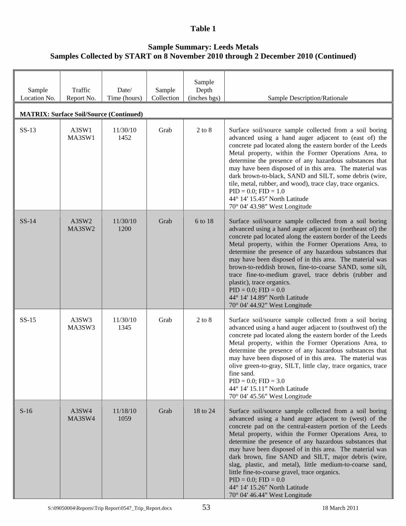
Table 1
Sample Summary: Leeds Metals Samples Collected by START on 8 November 2010 through 2 December 2010 (Continued)
S:\09050004\Reports\Trip Report\0547_Trip_Report.docx 53 18 March 2011
Sample Location No.
Traffic Report No.
Date/ Time (hours)
Sample Collection
Sample Depth
(inches bgs) Sample Description/Rationale
MATRIX: Surface Soil/Source (Continued)
SS-13 A3SW1 MA3SW1
11/30/10 1452
Grab 2 to 8 Surface soil/source sample collected from a soil boring advanced using a hand auger adjacent to (east of) the concrete pad located along the eastern border of the Leeds Metal property, within the Former Operations Area, to determine the presence of any hazardous substances that may have been disposed of in this area. The material was dark brown-to-black, SAND and SILT, some debris (wire, tile, metal, rubber, and wood), trace clay, trace organics. PID = 0.0; FID = 1.0 44° 14′ 15.45″ North Latitude 70° 04′ 43.98″ West Longitude
SS-14 A3SW2 MA3SW2
11/30/10 1200
Grab 6 to 18 Surface soil/source sample collected from a soil boring advanced using a hand auger adjacent to (northeast of) the concrete pad located along the eastern border of the Leeds Metal property, within the Former Operations Area, to determine the presence of any hazardous substances that may have been disposed of in this area. The material was brown-to-reddish brown, fine-to-coarse SAND, some silt, trace fine-to-medium gravel, trace debris (rubber and plastic), trace organics. PID = 0.0; FID = 0.0 44° 14′ 14.89″ North Latitude 70° 04′ 44.92″ West Longitude
SS-15 A3SW3 MA3SW3
11/30/10 1345
Grab 2 to 8 Surface soil/source sample collected from a soil boring advanced using a hand auger adjacent to (southwest of) the concrete pad located along the eastern border of the Leeds Metal property, within the Former Operations Area, to determine the presence of any hazardous substances that may have been disposed of in this area. The material was olive green-to-gray, SILT, little clay, trace organics, trace fine sand. PID = 0.0; FID = 3.0 44° 14′ 15.11″ North Latitude 70° 04′ 45.56″ West Longitude
S-16 A3SW4 MA3SW4
11/18/10 1059
Grab 18 to 24 Surface soil/source sample collected from a soil boring advanced using a hand auger adjacent to (west) of the concrete pad on the central-eastern portion of the Leeds Metal property, within the Former Operations Area, to determine the presence of any hazardous substances that may have been disposed of in this area. The material was dark brown, fine SAND and SILT, major debris (wire, slag, plastic, and metal), little medium-to-coarse sand, little fine-to-coarse gravel, trace organics. PID = 0.0; FID = 0.0 44° 14′ 15.26″ North Latitude 70° 04′ 46.44″ West Longitude

Table 1
Sample Summary: Leeds Metals Samples Collected by START on 8 November 2010 through 2 December 2010 (Continued)
S:\09050004\Reports\Trip Report\0547_Trip_Report.docx 54 18 March 2011
Sample Location No.
Traffic Report No.
Date/ Time (hours)
Sample Collection
Sample Depth
(inches bgs) Sample Description/Rationale
MATRIX: Surface Soil/Source (Continued)
SS-17 A3SW5 MA3SW5
11/18/10 1100
Grab 0 to 24 Surface soil/source sample collected from a soil boring advanced using a hand auger adjacent to (east of) Debris Pile B on the southeastern corner of the Leeds Metal property, within the Former Operations Area, to determine the presence of any hazardous substances that may have been disposed of in this area. The material was brown, fine-to-coarse SAND, some silt and debris (melted metal, wire, foam, and rubber), little fine-to-coarse gravel, trace clay. PID = 0.0; FID = 0.0 44° 14′ 12.62″ North Latitude 70° 04′ 42.75″ West Longitude
SS-18 A3SW6 MA3SW6
11/18/10 1035
Grab 6 to 12 Surface soil/source sample collected from a soil boring advanced using a hand auger adjacent to a concrete pad on the southeastern corner of the Leeds Metal property, within the Former Operations Area, to determine the presence of any hazardous substances that may have been disposed of in this area. The material was brown-to-yellow-brown, SILT, trace organics, trace fine sand. PID = 0.0; FID = 0.0 44° 14′ 14.03″ North Latitude 70° 04′ 44.23″ West Longitude
SS-19 A3SW7 MA3SW7
11/17/10 0845
Grab 12 to 16 Surface soil/source sample collected from a soil boring advanced using a hand auger from a small debris area located west of Debris Pile D, on the southern portion of Leeds Metal property, to determine the presence of any hazardous substances that may have been disposed of in this area. The material was medium-to-coarse sand, some fine SAND, little silt, trace debris (rubber), trace fine-to-coarse gravel. PID = 0.0; FID = 0.0 44° 14′ 09.14″ North Latitude 70° 04′ 53.69″ West Longitude
SS-20 A3SW8 MA3SW8
11/11/10 0905
Grab 12 to 24 Surface soil/source sample collected from a soil boring advanced using a hand auger adjacent to the north-northwest toe-slope of Debris Pile D, to determine the presence of any hazardous substances that may have been disposed of in this area. The material was dark brown, fine SAND and SILT, some medium-to-coarse sand and debris (foam, wire coating, rubber, and metal), trace organics, trace fine-to-coarse gravel, trace clay. PID = 0.0; FID = 0.0 44° 14′ 10.60″ North Latitude 70° 04′ 51.09″ West Longitude

Table 1
Sample Summary: Leeds Metals Samples Collected by START on 8 November 2010 through 2 December 2010 (Continued)
S:\09050004\Reports\Trip Report\0547_Trip_Report.docx 55 18 March 2011
Sample Location No.
Traffic Report No.
Date/ Time (hours)
Sample Collection
Sample Depth
(inches bgs) Sample Description/Rationale
MATRIX: Surface Soil/Source (Continued)
SS-21 A3SW9 MA3SW9
11/18/10 0920
Grab 0 to 18 Surface soil/source sample collected from a soil boring advanced using a hand auger adjacent to Debris Pile D on the southern portion of the Leeds Metal property, within the Former Operations Area, to determine the presence of any hazardous substances that may have been disposed of in this area. The material was dark brown, SILTY SAND, major debris (wire, rubber, metal slag, plastic, and paper), trace organics, trace fine-to-coarse gravel. PID = 0.0; FID = 0.0 44° 14′ 10.43″ North Latitude 70° 04′ 49.49″ West Longitude
SS-22 A3SX0 MA3SX0
11/18/10 0920
Grab 12 to 18 Surface soil/source sample collected from a soil boring advanced using a hand auger adjacent to Debris Pile D on the southern portion of the Leeds Metal property, within the Former Operations Area, to determine the presence of any hazardous substances that may have been disposed of in this area. The material was dark brown, SAND and SILT, some debris (metal and rubber), trace fine-to-coarse gravel, trace organics, trace clay. PID = 0.0; FID = 0.0 44° 14′ 10.59″ North Latitude 70° 04′ 50.88″ West Longitude
SS-23 A3SX1 MA3SX1
11/18/10 0845
Grab 0 to 12 Surface soil/source sample collected from a soil boring advanced using a hand auger adjacent to Debris Pile D on the southern portion of the Leeds Metal property, within the Former Operations Area, to determine the presence of any hazardous substances that may have been disposed of in this area. The material was brown-to-dark brown, SILTY SAND, major debris (metal, rubber, foam, plastic, paper), trace fine gravel, trace organics, burned odor. PID = 0.0; FID = 0.0 44° 14′ 10.74″ North Latitude 70° 04′ 50.72″ West Longitude

Table 1
Sample Summary: Leeds Metals Samples Collected by START on 8 November 2010 through 2 December 2010 (Continued)
S:\09050004\Reports\Trip Report\0547_Trip_Report.docx 56 18 March 2011
Sample Location No.
Traffic Report No.
Date/ Time (hours)
Sample Collection
Sample Depth
(inches bgs) Sample Description/Rationale
MATRIX: Surface Soil/Source (Continued)
SS-24 A3SX2 MA3SX2
11/18/10 0850
Grab 0 to 12 Surface soil/source sample collected from a soil boring advanced using a hand auger adjacent to Debris Pile D on the southern portion of the Leeds Metal property, within the Former Operations Area, to determine the presence of any hazardous substances that may have been disposed of in this area. The material was brown-to-cinnamon brown, fine SAND, some silt, little medium-to-coarse sand, trace fine-to-coarse gravel, trace clay. PID = 0.0; FID = 0.0 44° 14′ 10.53″ North Latitude 70° 04′ 50.33″ West Longitude
SS-25 A3SX3 MA3SX3
11/9/10 1357
Grab 6 to 18 Surface soil/source sample collected from a soil boring advanced using a hand auger from the Former Operations Area of the Leeds Metal property, to determine the presence of any hazardous substances that may have been disposed of in this area. The sample was collected from a slight depression located approximately 20 feet northwest of the bottom toe-slope of Debris Pile D. The material was dark brown, SAND and SILT, some debris (wire, rubber, metal), trace organics, trace clay, trace fine gravel. PID = 0.0; FID = 0.0 44° 14′ 10.69″ North Latitude 70° 04′ 50.37″ West Longitude
SS-26 A3SX4 MA3SX4
11/9/10 1355
Grab 0 to 18 Surface soil/source sample collected from a soil boring advanced using a hand auger from the Former Operations Area of the Leeds Metal property, to determine the presence of any hazardous substances that may have been disposed of in this area. The sample was collected approximately 10 feet northwest of the bottom toe-slope of Debris Pile D. The material was brown-to-dark brown, SAND and SILT, some debris (plastic, rubber, and metal), little clay, little fine-to-coarse gravel, trace organics. PID = 0.5; FID = 0.0 44° 14′ 10.45″ North Latitude 70° 04′ 49.91″ West Longitude

Table 1
Sample Summary: Leeds Metals Samples Collected by START on 8 November 2010 through 2 December 2010 (Continued)
S:\09050004\Reports\Trip Report\0547_Trip_Report.docx 57 18 March 2011
Sample Location No.
Traffic Report No.
Date/ Time (hours)
Sample Collection
Sample Depth
(inches bgs) Sample Description/Rationale
MATRIX: Surface Soil/Source (Continued)
SS-27 A3SX5 MA3SX5
11/18/10 0854
Grab 12 to 14 Surface soil/source sample collected from a soil boring advanced using a hand auger adjacent to Debris Pile D on the southern portion of the Leeds Metal property, within the Former Operations Area, to determine the presence of any hazardous substances that may have been disposed of in this area. The material was dark brown, SAND and SILT, some debris (metal, plastic, and rubber), trace fine gravel, trace organics, trace clay. PID = 4.0; FID = 4.0 44° 14′ 10.62″ North Latitude 70° 04′ 50.62″ West Longitude
SS-28 A3SX6 MA3SX6
11/9/10 1355
Grab 6 to 15 Surface soil/source sample collected from a soil boring advanced using a hand auger from the eastern slope of Debris Pile D, to determine the presence of any hazardous substances that may have been disposed of in this area. The material was brown-to-yellow-brown, SAND and SILT, major debris (metal, rubber, foam, plastic, wire, and wire coating), trace clay, trace organics. PID = 0.0; FID = 0.0 44° 14′ 09.90″ North Latitude 70° 04′ 49.24″ West Longitude
SS-29 A3SX7 MA3SX7
11/9/10 1400
Grab 12 to 24 Surface soil/source sample collected from a soil boring advanced using a hand auger from the southern slope of Debris Pile D, to determine the presence of any hazardous substances that may have been disposed of in this area. The material was brown, SAND and SILT, major debris (plastic, wire, metal, rubber, and foam), trace organics, trace fine gravel, trace clay. PID = 0.0; FID = 0.0 44° 14′ 09.49″ North Latitude 70° 04′ 51.13″ West Longitude
SS-30 A3SX8 MA3SX8
11/9/10 1405
Grab 0 to 24 Surface soil/source sample collected from a soil boring advanced using a hand auger from the western slope of Debris Pile D, to determine the presence of any hazardous substances that may have been disposed of in this area. The material was dark brown, SAND and SILT, major debris (plastic, paper, foam, metal, rubber, wood, and wire coating), trace clay. PID = 0.0; FID = 0.0 44° 14′ 09.91″ North Latitude 70° 04′ 51.54″ West Longitude
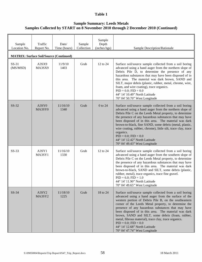
Table 1
Sample Summary: Leeds Metals Samples Collected by START on 8 November 2010 through 2 December 2010 (Continued)
S:\09050004\Reports\Trip Report\0547_Trip_Report.docx 58 18 March 2011
Sample Location No.
Traffic Report No.
Date/ Time (hours)
Sample Collection
Sample Depth
(inches bgs) Sample Description/Rationale
MATRIX: Surface Soil/Source (Continued)
SS-31 (MS/MSD)
A3SX9 MA3SX9
11/9/10 1403
Grab 12 to 24 Surface soil/source sample collected from a soil boring advanced using a hand auger from the northern slope of Debris Pile D, to determine the presence of any hazardous substances that may have been disposed of in this area. The material was dark brown, SAND and SILT, major debris (plastic, rubber, metal, chrome, wire, foam, and wire coating), trace organics. PID = 0.0; FID = 0.0 44° 14′ 10.49″ North Latitude 70° 04′ 50.70″ West Longitude
SS-32 A3SY0 MA3SY0
11/16/10 1340
Grab 0 to 24 Surface soil/source sample collected from a soil boring advanced using a hand auger from the northern slope of Debris Pile C on the Leeds Metal property, to determine the presence of any hazardous substances that may have been disposed of in this area. The material was dark brown-to-black, fine SAND, some debris (metal, plastic, wire coating, rubber, chrome), little silt, trace clay, trace organics. PID = 0.0; FID = 0.0 44° 14′ 12.42″ North Latitude 70° 04′ 49.43″ West Longitude
SS-33 A3SY1 MA3SY1
11/16/10 1330
Grab 12 to 24 Surface soil/source sample collected from a soil boring advanced using a hand auger from the southern slope of Debris Pile C on the Leeds Metal property, to determine the presence of any hazardous substances that may have been disposed of in this area. The material was dark brown-to-black, SAND and SILT, some debris (plastic, rubber, metal), trace organics, trace fine gravel. PID = 6.0; FID = 1.0 44° 14′ 11.90″ North Latitude 70° 04′ 49.65″ West Longitude
SS-34 A3SY2 MA3SY2
11/18/10 1225
Grab 18 to 24 Surface soil/source sample collected from a soil boring advanced using a hand auger from the surface of the western portion of Debris Pile B, on the southeastern corner of the Leeds Metal property, to determine the presence of any hazardous substances that may have been disposed of in this area. The material was dark brown, SAND and SILT, some debris (foam, rubber, metal, fibrous material), trace clay, trace organics. PID = 0.0; FID = 0.0 44° 14′ 12.68″ North Latitude 70° 04′ 47.74″ West Longitude

Table 1
Sample Summary: Leeds Metals Samples Collected by START on 8 November 2010 through 2 December 2010 (Continued)
S:\09050004\Reports\Trip Report\0547_Trip_Report.docx 59 18 March 2011
Sample Location No.
Traffic Report No.
Date/ Time (hours)
Sample Collection
Sample Depth
(inches bgs) Sample Description/Rationale
MATRIX: Surface Soil/Source (Continued)
SS-35 A3SY3 MA3SY3
11/18/10 1150
Grab 18 to 24 Surface soil/source sample collected from a soil boring advanced using a hand auger from the surface of the northeastern portion of Debris Pile B, on the southeastern corner of the Leeds Metal property, to determine the presence of any hazardous substances that may have been disposed of in this area. The material was dark brown-to-black, major DEBRIS (rubber and cloth), little fine-to-coarse sand, little clay, trace organics, trace fine-to-coarse gravel. PID = 0.0; FID = 0.0 44° 14′ 13.00″ North Latitude 70° 04′ 45.00″ West Longitude
SS-36 A3SY4 MA3SY4
11/18/10 1201
Grab 18 to 24 Surface soil/source sample collected from a soil boring advanced using a hand auger from the southern slope of Debris Pile B, on the southeastern corner of the Leeds Metal property, to determine the presence of any hazardous substances that may have been disposed of in this area. The material was dark brown, SILT, little debris (woven fabric, metal, rubber, and wire), little fine sand, trace organics, trace clay, trace medium-to-coarse sand. PID = 0.0; FID = 0.0 44° 14′ 11.82″ North Latitude 70° 04′ 46.59″ West Longitude
SS-37 A3SY5 MA3SY5
11/17/10 0935
Grab 0 to 24 Surface soil/source sample collected from a soil boring advanced using a hand auger from an area of drum disposal located south of the Leeds Metal property, along the southern property boundary, to determine the presence of any hazardous substances that may have been disposed of in this area. The material was brown-to-cinnamon brown, fine SAND and SILT, trace organics, trace medium-to-coarse sand, trace clay. PID = 0.0; FID = 0.0 44° 14′ 11.75″ North Latitude 70° 04′ 42.90″ West Longitude
SS-38 A3SY6 MA3SY6
11/17/10 0857
Grab 6 to 10 Surface soil/source sample collected from a soil boring advanced using a hand auger from an area of drum disposal located along the southern property boundary of the Leeds Metal property, to determine the presence of any hazardous substances that may have been disposed of in this area. The material was dark brown, SILT, little fine sand, trace organics, trace clay. PID = 0.0; FID = 0.0 44° 14′ 09.56″ North Latitude 70° 04′ 46.37″ West Longitude

Table 1
Sample Summary: Leeds Metals Samples Collected by START on 8 November 2010 through 2 December 2010 (Continued)
S:\09050004\Reports\Trip Report\0547_Trip_Report.docx 60 18 March 2011
Sample Location No.
Traffic Report No.
Date/ Time (hours)
Sample Collection
Sample Depth
(inches bgs) Sample Description/Rationale
MATRIX: Surface Soil/Source (Continued)
SS-39 A3SY7 MA3SY7
11/17/10 0855
Grab 0 to 24 Surface soil/source sample collected from a soil boring advanced using a hand auger from an area of drum disposal located south of the Leeds Metal property, to determine the presence of any hazardous substances that may have been disposed of in this area. The material was dark brown, SAND and SILT, major debris (rubber, plastic, wire, and foam), trace organics, trace clay. PID = 0.0; FID = 0.0 44° 14′ 11.45″ North Latitude 70° 04′ 43.06″ West Longitude
SS-40 A3SY8 MA3SY8
11/17/10 1422
Grab 18 to 22 Surface soil/source sample collected from a soil boring advanced using a hand auger from a wooded area, located southeast of the lagoons in the northwestern portion of the Leeds Metal property, to determine the presence of any hazardous substances that may have been disposed of in this area. The sample was collected near the western edge of an area containing surface debris. The material was light brown-to-brown, fine-to-coarse SAND, some silt, little fine gravel, trace clay. PID = 0.0; FID = 0.0 44° 14′ 10.86″ North Latitude 70° 04′ 54.54″ West Longitude
SS-41 (MS/MSD)
A3SY9 MA3SY9
11/17/10 1510
Grab 6 to 8 Surface soil/source sample collected from a soil boring advanced using a hand auger from a gully, within a wooded area along the site access road on the northeastern portion of the Leeds Metal property, to determine the presence of any hazardous substances that may have been disposed of in this area. The sample was collected from a location among 55-gallon steel drums. The material was light brown-to-brown, fine SAND and SILT, trace organics and clay. PID = 0.0; FID = 0.0 44° 14′ 18.38″ North Latitude 70° 04′ 48.46″ West Longitude
SS-42 A3SZ0 MA3SZ0
11/17/10 1415
Grab 0 to 12 Surface soil/source sample collected from a soil boring advanced using a hand auger from a wooded area, located southeast of the lagoons in the northwestern portion of the Leeds Metal property, to determine the presence of any hazardous substances that may have been disposed of in this area. The sample was collected near the western edge of an area containing surface debris. The material was brown, SAND and SILT, trace fine-to-medium gravel, trace organics, trace clay. PID = 0.0; FID = 0.0 44° 14′ 15.15″ North Latitude 70° 04′ 52.18″ West Longitude

Table 1
Sample Summary: Leeds Metals Samples Collected by START on 8 November 2010 through 2 December 2010 (Continued)
S:\09050004\Reports\Trip Report\0547_Trip_Report.docx 61 18 March 2011
Sample Location No.
Traffic Report No.
Date/ Time (hours)
Sample Collection
Sample Depth
(inches bgs) Sample Description/Rationale
MATRIX: Surface Soil/Source (Concluded)
SS-43 A3SZ1 MA3SZ1
11/16/10 1450
Grab 0 to 10 Field Duplicate of SS-05, collected for quality control.
SS-44 A3SZ2 MA3SZ2
11/11/10 0905
Grab 12 to 24 Field Duplicate of SS-20, collected for quality control.
SS-50 (MS/MSD)
A3T03 MA3T03
11/18/10 1430
Grab 2 to 6 Surface soil/source sample collected from a soil boring advanced using a hand auger adjacent to (southwest of) the large concrete pad along the eastern property boundary of the Leeds Metal property, within the Former Operations Area, to determine the presence of any hazardous substances that may have been disposed of in this area. The material was black, fine SAND and SILT, some debris (metal, wire, plastic), little medium-to-coarse sand, little fine gravel, trace clay. PID = 0.0; FID = 0.0 44° 14′ 14.80″ North Latitude 70° 04′ 45.41″ West Longitude
SS-52 (MS/MSD)
A3TR8 MA3TR8
11/30/10 1130
Grab 16 to 24 Surface soil/source sample collected from a soil boring advanced using a hand auger adjacent to (southwest of) the concrete pad located along the eastern border of the Leeds Metal property, within the Former Operations Area, to determine the presence of any hazardous substances that may have been disposed of in this area. The material was olive-green-to-gray, SILT, some fine sand, trace organics, trace clay. PID = 0.0; FID = 0.0 44° 14′ 15.34″ North Latitude 70° 04′ 45.51″ West Longitude
SS-53 A3TR9 MA3TR9
11/30/10 1345
Grab 2 to 8 Field Duplicate of SS-15, collected for quality control.
MATRIX: Subsurface Soil/Source
SB-01 A3SZ3 MA3SZ3
11/16/10 1100
Grab 36 to 48 Subsurface soil/source sample collected from a soil boring advanced using a hand auger from 23 Plains Road (Town of Leeds, ME Tax Assessor’s Map No. 4, Lot No. 55), northwest of the Leeds Metal property, to document background soil conditions for comparison purposes. The material was brown, SAND and SILT, trace fine gravel, trace organics, trace clay. PID = 0.0; FID = 0.0 44° 14′ 34.62″ North Latitude 70° 05′ 11.02″ West Longitude

Table 1
Sample Summary: Leeds Metals Samples Collected by START on 8 November 2010 through 2 December 2010 (Continued)
S:\09050004\Reports\Trip Report\0547_Trip_Report.docx 62 18 March 2011
Sample Location No.
Traffic Report No.
Date/ Time (hours)
Sample Collection
Sample Depth
(inches bgs) Sample Description/Rationale
MATRIX: Subsurface Soil/Source (Continued)
SB-02 MA3SZ4 11/16/10 1115
Grab 36 to 48 Subsurface soil/source sample collected from a soil boring advanced using a hand auger from 23 Plains Road (Town of Leeds, ME Tax Assessor’s Map No. 4, Lot No. 55), northwest of the Leeds Metal property, to document background soil conditions for comparison purposes (total metals analysis only). The material was brown, SAND and SILT, trace fine gravel, trace organics, trace clay. PID = 0.0; FID = 0.0 44° 14′ 34.65″ North Latitude 70° 05′ 11.01″ West Longitude
SB-08 A3SZ5 MA3SZ5
11/18/10 1455
Grab 66 to 72 Subsurface soil/source sample collected from a soil boring advanced using a hand auger near a former railroad spur along the eastern property boundary of the Leeds Metal property, within the Former Operations Area, to determine the presence of any hazardous substances that may have been disposed of in this area. The material was brown-to-gray, fine-to-coarse SAND, little silt, trace fine gravel, trace clay. PID = 0.0; FID = 0.0 44° 14′ 18.21″ North Latitude 70° 04′ 44.96″ West Longitude
SB-09 A3SZ6 MA3SZ6
11/18/10 1455
Grab 24 to 36 Subsurface soil/source sample collected from a soil boring advanced using a hand auger in a depression/gulley along the eastern boundary of the Leeds Metal property, within the Former Operations Area, to determine the presence of any hazardous substances that may have been disposed of in this area. The material was dark brown, SAND and SILT, major debris (metal, rubber, plastic, and wire), trace organics, trace clay. PID = 0.0; FID = 0.0 44° 14′ 17.70″ North Latitude 70° 04′ 46.13″ West Longitude
SB-10 A3SZ7 MA3SZ7
11/30/10 1120
Grab 30 to 36 Subsurface soil/source sample collected from a soil boring advanced using a hand auger adjacent to (north of) the concrete pad located along the eastern border of the Leeds Metal property, within the Former Operations Area, to determine the presence of any hazardous substances that may have been disposed of in this area. The material was brown, SAND and SILT, trace fine-to-coarse gravel, trace organics, trace debris (plastic). PID = 0.0; FID = 0.0 44° 14′ 16.38″ North Latitude 70° 04′ 46.36″ West Longitude
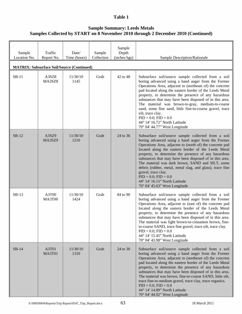
Table 1
Sample Summary: Leeds Metals Samples Collected by START on 8 November 2010 through 2 December 2010 (Continued)
S:\09050004\Reports\Trip Report\0547_Trip_Report.docx 63 18 March 2011
Sample Location No.
Traffic Report No.
Date/ Time (hours)
Sample Collection
Sample Depth
(inches bgs) Sample Description/Rationale
MATRIX: Subsurface Soil/Source (Continued)
SB-11 A3SZ8 MA3SZ8
11/30/10 1145
Grab 42 to 48 Subsurface soil/source sample collected from a soil boring advanced using a hand auger from the Former Operations Area, adjacent to (northeast of) the concrete pad located along the eastern border of the Leeds Metal property, to determine the presence of any hazardous substances that may have been disposed of in this area. The material was brown-to-gray, medium-to-coarse sand, some fine sand, little fine-to-coarse gravel, trace silt, trace clay. PID = 0.0; FID = 0.0 44° 14′ 16.72″ North Latitude 70° 04′ 44.77″ West Longitude
SB-12 A3SZ9 MA3SZ9
11/30/10 1210
Grab 24 to 36 Subsurface soil/source sample collected from a soil boring advanced using a hand auger from the Former Operations Area, adjacent to (north of) the concrete pad located along the eastern border of the Leeds Metal property, to determine the presence of any hazardous substances that may have been disposed of in this area. The material was dark brown, SAND and SILT, some debris (rubber, metal, metal slag, and glass), trace fine gravel, trace clay. PID = 0.0; FID = 0.0 44° 14′ 16.15″ North Latitude 70° 04′ 45.63″ West Longitude
SB-13 A3T00 MA3T00
11/30/10 1424
Grab 84 to 90 Subsurface soil/source sample collected from a soil boring advanced using a hand auger from the Former Operations Area, adjacent to (east of) the concrete pad located along the eastern border of the Leeds Metal property, to determine the presence of any hazardous substances that may have been disposed of in this area. The material was light brown-to-cinnamon brown, fine-to-coarse SAND, trace fine gravel, trace silt, trace clay. PID = 0.0; FID = 0.0 44° 14′ 15.45″ North Latitude 70° 04′ 43.98″ West Longitude
SB-14 A3T01 MA3T01
11/30/10 1310
Grab 24 to 30 Subsurface soil/source sample collected from a soil boring advanced using a hand auger from the Former Operations Area, adjacent to (northeast of) the concrete pad located along the eastern border of the Leeds Metal property, to determine the presence of any hazardous substances that may have been disposed of in this area. The material was brown, fine-to-coarse SAND, little silt, trace fine-to-medium gravel, trace clay, trace organics. PID = 0.0; FID = 0.0 44° 14′ 14.89″ North Latitude 70° 04′ 44.92″ West Longitude

Table 1
Sample Summary: Leeds Metals Samples Collected by START on 8 November 2010 through 2 December 2010 (Continued)
S:\09050004\Reports\Trip Report\0547_Trip_Report.docx 64 18 March 2011
Sample Location No.
Traffic Report No.
Date/ Time (hours)
Sample Collection
Sample Depth
(inches bgs) Sample Description/Rationale
MATRIX: Subsurface Soil/Source (Continued)
SB-15 A3T02 MA3T02
11/30/10 1400
Grab 42 to 48 Subsurface soil/source sample collected from a soil boring advanced using a hand auger from the Former Operations Area, adjacent to (southwest of) the concrete pad located along the eastern border of the Leeds Metal property, to determine the presence of any hazardous substances that may have been disposed of in this area. The material was light brown-to-brown, SAND, little silt, little fine-to-coarse gravel, trace clay, trace debris, trace organics. PID = 0.0; FID = 0.0 44° 14′ 15.11″ North Latitude 70° 04′ 45.56″ West Longitude
SB-17 A3T04 MAT04
11/18/10 1135
Grab 24 to 48 Subsurface soil/source sample collected from a soil boring advanced using a hand auger from the Former Operations Area, adjacent to (east of) Debris Pile B on the southeastern corner of the Leeds Metal property, to determine the presence of any hazardous substances that may have been disposed of in this area. The material was light brown-to-brown, SAND, some silt, little fine-to-coarse gravel, trace clay. PID = 0.0; FID = 0.0 44° 14′ 12.62″ North Latitude 70° 04′ 42.75″ West Longitude
SB-18 A3T05 MA3T05
11/18/10 1100
Grab 66 to 72 Subsurface soil/source sample collected from a soil boring advanced using a hand auger from the Former Operations Area, adjacent to a concrete pad on the southeastern corner of the Leeds Metal property, to determine the presence of any hazardous substances that may have been disposed of in this area. The material was light brown-to-brown, major SILT, fine sand, little clay. PID = 0.0; FID = 0.0 44° 14′ 14.03″ North Latitude 70° 04′ 44.23″ West Longitude
SB-22 A3T06 MA3T06
11/18/10 0950
Grab 60 to 72 Subsurface soil/source sample collected from a soil boring advanced using a hand auger from the Former Operations Area, adjacent to Debris Pile D on the southern portion of the Leeds Metal property, to determine the presence of any hazardous substances that may have been disposed of in this area. The material was gray, fine-to-medium SAND, little coarse sand, some silt, trace clay, saturated. PID = 0.0; FID = 0.0 44° 14′ 10.59″ North Latitude 70° 04′ 50.88″ West Longitude
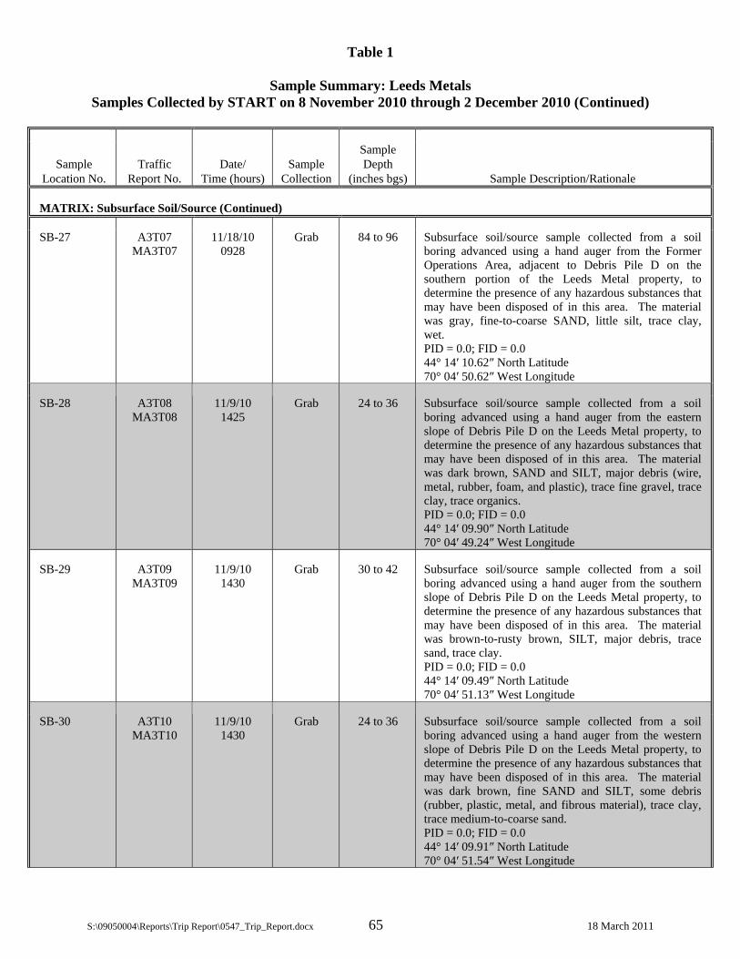
Table 1
Sample Summary: Leeds Metals Samples Collected by START on 8 November 2010 through 2 December 2010 (Continued)
S:\09050004\Reports\Trip Report\0547_Trip_Report.docx 65 18 March 2011
Sample Location No.
Traffic Report No.
Date/ Time (hours)
Sample Collection
Sample Depth
(inches bgs) Sample Description/Rationale
MATRIX: Subsurface Soil/Source (Continued)
SB-27 A3T07 MA3T07
11/18/10 0928
Grab 84 to 96 Subsurface soil/source sample collected from a soil boring advanced using a hand auger from the Former Operations Area, adjacent to Debris Pile D on the southern portion of the Leeds Metal property, to determine the presence of any hazardous substances that may have been disposed of in this area. The material was gray, fine-to-coarse SAND, little silt, trace clay, wet. PID = 0.0; FID = 0.0 44° 14′ 10.62″ North Latitude 70° 04′ 50.62″ West Longitude
SB-28 A3T08 MA3T08
11/9/10 1425
Grab 24 to 36 Subsurface soil/source sample collected from a soil boring advanced using a hand auger from the eastern slope of Debris Pile D on the Leeds Metal property, to determine the presence of any hazardous substances that may have been disposed of in this area. The material was dark brown, SAND and SILT, major debris (wire, metal, rubber, foam, and plastic), trace fine gravel, trace clay, trace organics. PID = 0.0; FID = 0.0 44° 14′ 09.90″ North Latitude 70° 04′ 49.24″ West Longitude
SB-29 A3T09 MA3T09
11/9/10 1430
Grab 30 to 42 Subsurface soil/source sample collected from a soil boring advanced using a hand auger from the southern slope of Debris Pile D on the Leeds Metal property, to determine the presence of any hazardous substances that may have been disposed of in this area. The material was brown-to-rusty brown, SILT, major debris, trace sand, trace clay. PID = 0.0; FID = 0.0 44° 14′ 09.49″ North Latitude 70° 04′ 51.13″ West Longitude
SB-30 A3T10 MA3T10
11/9/10 1430
Grab 24 to 36 Subsurface soil/source sample collected from a soil boring advanced using a hand auger from the western slope of Debris Pile D on the Leeds Metal property, to determine the presence of any hazardous substances that may have been disposed of in this area. The material was dark brown, fine SAND and SILT, some debris (rubber, plastic, metal, and fibrous material), trace clay, trace medium-to-coarse sand. PID = 0.0; FID = 0.0 44° 14′ 09.91″ North Latitude 70° 04′ 51.54″ West Longitude

Table 1
Sample Summary: Leeds Metals Samples Collected by START on 8 November 2010 through 2 December 2010 (Continued)
S:\09050004\Reports\Trip Report\0547_Trip_Report.docx 66 18 March 2011
Sample Location No.
Traffic Report No.
Date/ Time (hours)
Sample Collection
Sample Depth
(inches bgs) Sample Description/Rationale
MATRIX: Subsurface Soil/Source (Continued)
SB-31 A3T11 MA3T11
11/9/10 1430
Grab 54 to 72 Subsurface soil/source sample collected from a soil boring advanced using a hand auger from the northern slope of Debris Pile D on the Leeds Metal property, to determine the presence of any hazardous substances that may have been disposed of in this area. The material was dark brown, SILT, major debris (plastic, metal, rubber, linoleum, foam, tile, and wire), little sand, trace clay. PID = 0.0; FID = 0.0 44° 14′ 10.49″ North Latitude 70° 04′ 50.70″ West Longitude
SB-32 A3T12 MA3T12
11/16/10 1400
Grab 24 to 36 Subsurface soil/source sample collected from a soil boring advanced using a hand auger from the northern slope of Debris Pile C on the Leeds Metal property, to determine the presence of any hazardous substances that may have been disposed of in this area. The material was dark brown-to-black, fine-to-medium SAND, some silt and debris (wire coating, woven fibers, metal, rubber, wire, foam, plastic, and linoleum), trace coarse sand, trace fine gravel, trace clay. PID = 0.0; FID = 0.0 44° 14′ 12.42″ North Latitude 70° 04′ 49.43″ West Longitude
SB-33 A3T13 MA3T13
11/16/10 1350
Grab 36 to 42 Subsurface soil/source sample collected from a soil boring advanced using a hand auger from the southern slope of Debris Pile C on the Leeds Metal property, to determine the presence of any hazardous substances that may have been disposed of in this area. The material was dark brown-to-black, SAND and SILT, some debris (wire, rubber, foam, metal, and plastic), trace clay. PID = 0.0; FID = 0.0 44° 14′ 11.90″ North Latitude 70° 04′ 49.65″ West Longitude
SB-34 A3T14 MA3T14
11/18/10 1315
Grab 24 to 32 Subsurface soil/source sample collected from a soil boring advanced using a hand auger from the surface of the western portion of Debris Pile B, to determine the presence of any hazardous substances that may have been disposed of in this area. The material was black, SILT, little clay, debris (rubber, foam, and plastic), and fine sand. PID = 0.0; FID = 0.0 44° 14′ 12.68″ North Latitude 70° 04′ 47.74″ West Longitude

Table 1
Sample Summary: Leeds Metals Samples Collected by START on 8 November 2010 through 2 December 2010 (Continued)
S:\09050004\Reports\Trip Report\0547_Trip_Report.docx 67 18 March 2011
Sample Location No.
Traffic Report No.
Date/ Time (hours)
Sample Collection
Sample Depth
(inches bgs) Sample Description/Rationale
MATRIX: Subsurface Soil/Source (Continued)
SB-35 A3T15 MA3T15
11/18/10 1245
Grab 72 to 78 Subsurface soil/source sample collected from a soil boring advanced using a hand auger from the surface of the northeastern portion of Debris Pile B, on the southeastern corner of the Leeds Metal property, to determine the presence of any hazardous substances that may have been disposed of in this area. The material was black, SILT, some debris (plastic and foam), trace clay, burned brake odor. PID = 0.0; FID = 1.0. 44° 14′ 13.00″ North Latitude 70° 04′ 45.00″ West Longitude
SB-36 A3T16 MA3T16
11/18/10 1236
Grab 110 to 120 Subsurface soil/source sample collected from a soil boring advanced using a hand auger from the southern slope of Debris Pile B, on the southeastern corner of the Leeds Metal property, to determine the presence of any hazardous substances that may have been disposed of in this area. The material was dark brown-to-black, SILT, some debris (metal, foam, cloth, plastic, wire), little clay, trace fine-to-coarse sand, trace organics, slight petroleum odor. PID = 0.0; FID = 0.0 44° 14′ 11.82″ North Latitude 70° 04′ 46.59″ West Longitude
SB-37 A3T17 MA3T17
11/17/10 0950
Grab 24 to 48 Subsurface soil/source sample collected from a soil boring advanced using a hand auger from an area of drum disposal located south of the Leeds Metal property, along the southern property boundary, to determine the presence of any hazardous substances that may have been disposed of in this area. The material was light brown-to-cinnamon brown, fine SAND, trace organics, trace fine gravel, trace medium-to-coarse sand, trace clay. PID = 0.0; FID = 0.0 44° 14′ 11.75″ North Latitude 70° 04′ 42.90″ West Longitude
SB-38 A3T18 MA3T18
11/17/10 0952
Grab 114 to 120 Subsurface soil/source sample collected from a soil boring advanced using a hand auger from an area of drum disposal located along the southern property boundary of the Leeds Metal property, to determine the presence of any hazardous substances that may have been disposed of in this area. The material was olive green-to-brown, SILT, little clay, trace fine sand, saturated. PID = 0.0; FID = 0.0 44° 14′ 09.56″ North Latitude 70° 04′ 46.37″ West Longitude

Table 1
Sample Summary: Leeds Metals Samples Collected by START on 8 November 2010 through 2 December 2010 (Continued)
S:\09050004\Reports\Trip Report\0547_Trip_Report.docx 68 18 March 2011
Sample Location No.
Traffic Report No.
Date/ Time (hours)
Sample Collection
Sample Depth
(inches bgs) Sample Description/Rationale
MATRIX: Subsurface Soil/Source (Concluded)
SB-40 A3S19 MA3S19
11/17/10 1444
Grab 42 to 48 Subsurface soil/source sample collected from a soil boring advanced using a hand auger from a wooded area, located southeast of the lagoons in the northwestern portion of the Leeds Metal property, to determine the presence of any hazardous substances that may have been disposed of in this area. The sample was collected near the western edge of an area containing surface debris. The material was brown-to-gray, fine-to-coarse SAND, trace fine-to-coarse gravel, trace silt. PID = 0.0; FID = 0.0 44° 14′ 10.86″ North Latitude 70° 04′ 54.54″ West Longitude
SB-42 A3T20 MA3T20
11/17/10 1430
Grab 36 to 42 Subsurface soil/source sample collected from a soil boring advanced using a hand auger from a wooded area, located southeast of the lagoons in the northwestern portion of the Leeds Metal property, to determine the presence of any hazardous substances that may have been disposed of in this area. The sample was collected near the western edge of an area containing surface debris. The material was olive green-to-brown, fine SAND and SILT, little clay. PID = 0.0; FID = 0.0 44° 14′ 15.15″ North Latitude 70° 04′ 52.18″ West Longitude
SB-43 A3T21 MA3T21
11/18/10 1236
Grab 110 to 120 Field Duplicate of SB-36, collected for quality control.
SB-44 A3T22 MA3T22
11/18/10 0928
Grab 84 to 96 Field Duplicate of SB-27, collected for quality control.

Table 1
Sample Summary: Leeds Metals Samples Collected by START on 8 November 2010 through 2 December 2010 (Continued)
S:\09050004\Reports\Trip Report\0547_Trip_Report.docx 69 18 March 2011
Sample Location No.
Traffic Report No.
Date/ Time (hours)
Sample Collection
Sample Depth
(feet bgs) Sample Description/Rationale
Matrix: Ground Water
GW-01 A3T57 MA3T57 MA3TN7
11/10/10 1225
Grab 9.3* Groundwater sample collected from monitoring well ERM-5S, in the central portion of the Leeds Metal property, to determine the presence of any hazardous substances in groundwater. The water quality parameters at the time of sample collection are as follows: Purge rate (mL/min) = 200; Volume purged (L) = 21; Temperature (°C) = 11.67; Sp. Conductivity (µS/cm) = 66; pH = 6.59; ORP (mv) = 101.9; DO (mg/L) = 17.25; Turbidity (NTU) = 1.76; PID= 0; Comments = None 44° 14′ 16.78″ North Latitude 70° 04′ 49.39″ West Longitude
GW-02 A3T58 MA3T58 MA3TN8
11/10/10 1315
Grab 17.71* Groundwater sample collected from monitoring well ERM-2S, in the southeast portion of the Leeds Metal property, to determine the presence of any hazardous substances in groundwater. The water quality parameters at the time of sample collection are as follows: Purge rate (mL/min) = 200; Volume purged (L) = 11; Temperature (°C) = 9.34; Sp. Conductivity (µS/cm) = 78; pH = 6.44; ORP (mv) = 234.3; DO (mg/L) = 5.92; Turbidity (NTU) = 0.23; PID = 0; Comments = None 44° 14′ 10.86″ North Latitude 70° 04′ 45.83″ West Longitude
GW-03 A3T59 MA3T59 MA3TN9
11/11/10 1427
Grab 19.07* Groundwater sample collected from monitoring well ERM-2D, in the southeast portion of the Leeds Metal property, to determine the presence of any hazardous substances in groundwater. The water quality parameters at the time of sample collection are as follows: Purge rate (mL/min) = 300; Volume purged (L) = 15; Temperature (°C) = 8.32; Sp. Conductivity (µS/cm ) = 198; pH = 8.06; ORP (mv) = 70.1; DO (mg/L) = 0.89; Turbidity (NTU) = 10.72; PID = 0; Comments = None 44° 14′ 10.87″ North Latitude 70° 04′ 45.83″ West Longitude
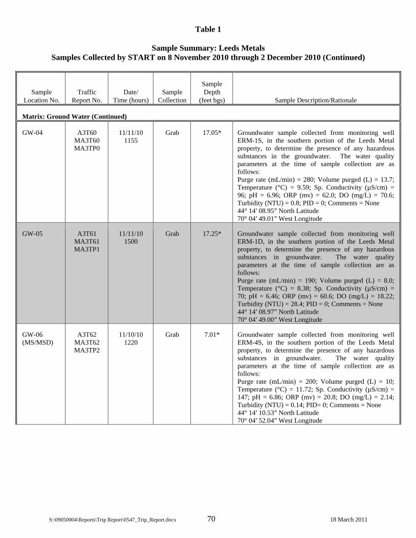
Table 1
Sample Summary: Leeds Metals Samples Collected by START on 8 November 2010 through 2 December 2010 (Continued)
S:\09050004\Reports\Trip Report\0547_Trip_Report.docx 70 18 March 2011
Sample Location No.
Traffic Report No.
Date/ Time (hours)
Sample Collection
Sample Depth
(feet bgs) Sample Description/Rationale
Matrix: Ground Water (Continued)
GW-04 A3T60 MA3T60 MA3TP0
11/11/10 1155
Grab 17.05* Groundwater sample collected from monitoring well ERM-1S, in the southern portion of the Leeds Metal property, to determine the presence of any hazardous substances in the groundwater. The water quality parameters at the time of sample collection are as follows: Purge rate (mL/min) = 280; Volume purged (L) = 13.7; Temperature (°C) = 9.59; Sp. Conductivity (µS/cm) = 96; pH = 6.96; ORP (mv) = 62.0; DO (mg/L) = 70.6; Turbidity (NTU) = 0.8; PID = 0; Comments = None 44° 14′ 08.95″ North Latitude 70° 04′ 49.01″ West Longitude
GW-05 A3T61 MA3T61 MA3TP1
11/11/10 1500
Grab 17.25* Groundwater sample collected from monitoring well ERM-1D, in the southern portion of the Leeds Metal property, to determine the presence of any hazardous substances in groundwater. The water quality parameters at the time of sample collection are as follows: Purge rate (mL/min) = 190; Volume purged (L) = 8.0; Temperature (°C) = 8.38; Sp. Conductivity (µS/cm) = 70; pH = 6.46; ORP (mv) = 60.6; DO (mg/L) = 18.22; Turbidity (NTU) = 28.4; PID = 0; Comments = None 44° 14′ 08.97″ North Latitude 70° 04′ 49.00″ West Longitude
GW-06 (MS/MSD)
A3T62 MA3T62 MA3TP2
11/10/10 1220
Grab 7.01* Groundwater sample collected from monitoring well ERM-4S, in the southern portion of the Leeds Metal property, to determine the presence of any hazardous substances in groundwater. The water quality parameters at the time of sample collection are as follows: Purge rate (mL/min) = 200; Volume purged (L) = 10; Temperature (°C) = 11.72; Sp. Conductivity (µS/cm) = 147; pH = 6.86; ORP (mv) = 20.8; DO (mg/L) = 2.14; Turbidity (NTU) = 0.14; PID= 0; Comments = None 44° 14′ 10.53″ North Latitude 70° 04′ 52.04″ West Longitude

Table 1
Sample Summary: Leeds Metals Samples Collected by START on 8 November 2010 through 2 December 2010 (Continued)
S:\09050004\Reports\Trip Report\0547_Trip_Report.docx 71 18 March 2011
Sample Location No.
Traffic Report No.
Date/ Time (hours)
Sample Collection
Sample Depth
(feet bgs) Sample Description/Rationale
Matrix: Ground Water (Continued)
GW-07 A3T63 MA3T63 MA3TP3
11/11/10 1212
Grab 6.50* Groundwater sample collected from monitoring well ERM-4D, in the southern portion of the Leeds Metal property, to determine the presence of any hazardous substances in groundwater. The water quality parameters at the time of sample collection are as follows: Purge rate (mL/min) = 500; Volume purged (L) = 30; Temperature (°C) = 10.35; Sp. Conductivity (µS/cm) = 174; pH = 6.86; ORP (mv) = 116.1; DO (mg/L) = 0.42; Turbidity (NTU) = 1.96; PID = 0; Comments = None 44° 14′ 10.52″ North Latitude 70° 04′ 52.01″ West Longitude
GW-08 A3T64 MA3T64 MA3TP4
11/11/10 1155
Grab 13.74* Groundwater sample collected from monitoring well ERM-3S, in the southern portion of the Leeds Metal property, to determine the presence of any hazardous substances in groundwater. The water quality parameters at the time of sample collection are as follows: Purge rate (mL/min) = 250; Volume purged (L) = 13.25; Temperature (°C) = 8.51; Sp. Conductivity (µS/cm) = 38; pH = 6.11; ORP (mv )= 250.2; DO (mg/L) = 10.90; Turbidity (NTU) = 0.38; PID = 0; Comments = None 44° 14′ 06.65″ North Latitude 70° 04′ 53.61″ West Longitude
GW-09 A3T65 MA3T65 MA3TP5
11/11/10 1635
Grab 16.47* Groundwater sample collected from monitoring well ERM-3D, in the southern of the Leeds Metal property, to determine the presence of any hazardous substances in groundwater. The water quality parameters at the time of sample collection are as follows: Purge rate (mL/min) = 200; Volume purged (L) = 24.5; Temperature (°C) = 7.52; Sp. Conductivity (µS/cm) = 55; pH = 9.00; ORP (mv) = 46.5; DO (mg/L) = 10.68; Turbidity (NTU) = 173; PID = 0; Comments = None 44° 14′ 06.66″ North Latitude 70° 04′ 53.57″ West Longitude
GW-10 A3T66 MA3T66 MA3TP6
11/11/10 1212
Grab 6.50* Field duplicate of GW-07, collected for quality control.

Table 1
Sample Summary: Leeds Metals Samples Collected by START on 8 November 2010 through 2 December 2010 (Continued)
S:\09050004\Reports\Trip Report\0547_Trip_Report.docx 72 18 March 2011
Sample Location No.
Traffic Report No.
Date/ Time (hours) Remarks
Sample Depth
(feet bgs) Sample Description/Rationale
Matrix: Ground Water (Concluded)
GW-11 A3TQ5 MA3TQ5 MA3TQ7
11/16/10 1035
Grab 6.57* Groundwater sample collected from monitoring well RX-3S, in the eastern portion of the Leeds Metal property, to determine the presence of any hazardous substances in groundwater. The water quality parameters at the time of sample collection are as follows: Purge rate (mL/min) = 260; Volume purged (L) = 9.1; Temperature (°C) = 8.13; Sp. Conductivity (µS/cm) = 237; pH = 9.62; ORP (mv) = 151.1; DO (mg/L) = 8.29; Turbidity (NTU) = 16.9; PID= 0; Comments = None 44° 14′ 20.19″ North Latitude 70° 04′ 53.70″ West Longitude
GW-12 A3TQ6 MA3TQ6 MA3TQ8
11/16/10 1125
Grab 4.88* Groundwater sample collected from monitoring well RX-2S, in the eastern portion of the Leeds Metal property, to determine the presence of any hazardous substances in groundwater. The water quality parameters at the time of sample collection are as follows: Purge rate (mL/min) = 300; Volume purged (L) = 16.3; Temperature (°C) = 12.11; Sp. Conductivity (µS/cm) = 190; pH = 6.44; ORP (mv) = -66.9; DO (mg/L) = 0.11; Turbidity (NTU) = 8.63; PID = 0; Comments = None 44° 14′ 18.14″ North Latitude 70° 04′ 55.54″ West Longitude

Table 1
Sample Summary: Leeds Metals Samples Collected by START on 8 November 2010 through 2 December 2010 (Continued)
S:\09050004\Reports\Trip Report\0547_Trip_Report.docx 73 18 March 2011
Sample Location No.
Traffic Report No.
Date/ Time (hours)
Sample Collection
Sample Depth
(feet bgs) Sample Description/Rationale
Matrix: Drinking Water
DW-01 A3T23 MA3T23 MA3TK3
11/8/10 1345
Grab NA Drinking water sample collected from a residence at 23 Plains Road (Town of Leeds, ME Tax Assessor’s Map No. 4, Lot No. 55), for reference comparison purposes. The residence is supplied drinking water from an on-site, 87-ft deep drilled overburden private supply well. The sample was collected from an in-line spigot utilizing a spigot adaptor, after system purging was completed and water quality parameters stabilized. The sample was collected after water flowed through a holding tank and prior to any filtration system. The water quality parameters at the time of sampling were as follows: Temperature (°C) = 11.1; Sp. Cond. (µS) = 73.7; pH (meter) = 6.31; PID = 0; CGI/O2 = 0/20.9; Turbidity (NTU) = 47.7 44° 14′ 32.89″ North Latitude 70° 05′ 11.28″ West Longitude
DW-02 A3T24 MA3T24 MA3TK4
11/16/10 1647
Grab NA Drinking water sample collected from a residence at 26 Plains Road (Town of Leeds, ME Tax Assessor’s Map No. 4, Lot No. 54), for reference comparison purposes. The residence is supplied drinking water from an on-site 200-ft deep drilled bedrock private supply well. The sample was collected from the kitchen sink spigot after system purging was completed and water quality parameters stabilized. The sample was collected after water flowed through an approximately 20-gallon holding tank and the home’s piping system. No filtration systems exist within the house. The water quality parameters at the time of sampling were as follows: Temperature (°C) = 10.2; Sp. Cond. (µS) = 283.8; pH (meter) = 8.77; PID = 0; CGI/O2 = 0/20.7; Turbidity (NTU) = 0.93 44° 14′ 31.89″ North Latitude 70° 05′ 11.28″ West Longitude

Table 1
Sample Summary: Leeds Metals Samples Collected by START on 8 November 2010 through 2 December 2010 (Continued)
S:\09050004\Reports\Trip Report\0547_Trip_Report.docx 74 18 March 2011
Sample Location No.
Traffic Report No.
Date/ Time (hours)
Sample Collection
Sample Depth
(feet bgs) Sample Description/Rationale
Matrix: Drinking Water
DW-03 A3T25 MA3T25 MA3TK5
11/16/10 1721
Grab NA Drinking water sample collected from a residence at 218 Route 106 (Town of Leeds, ME Tax Assessor’s Map No. 4, Lot No. 48), for reference comparison purposes. The residence is supplied drinking water from an on-site, 55-ft deep, drilled gravel-pack overburden private supply well. The sample was collected from an outside spigot after system purging was completed and water quality parameters stabilized. The sample was collected after water flowed through an approximately 30-gallon holding tank and the home’s piping system. The house filtration system was bypassed. The water quality parameters at the time of sampling were as follows: Temperature (°C) = 11.3; Sp. Cond. (µS) = 56.2; pH (meter) = 7.15; PID = 0; CGI/O2 = 0/20.7; Turbidity (NTU) = 0.31 44° 14′ 34.05″ North Latitude 70° 05′ 02.74″ West Longitude
DW-04 A3T26 MA3T26 MA3TK6
11/10/10 1708
Grab NA Drinking water sample collected from a residence at 3 Blue Rock Road (Town of Leeds, ME Tax Assessor’s Map No. 4, Lot No. 35), to determine whether local private drinking water supply wells have been impacted by sources located on the Leeds Metal property. The residence is supplied drinking water from an on-site, approximately 16- to 26-ft deep, dug overburden private supply well. The sample was collected from the kitchen sink spigot after system purging was completed and water quality parameters stabilized. The sample was collected after water flowed through an approximately 12- to 15-gallon holding tank and the home’s piping system, and prior to any filtration systems. According to the homeowner, the wellhead on the property is located outside in a pit approximately 12 feet below grade. The water quality parameters at the time of sampling were as follows: Temperature (°C) = 10.8; Sp. Cond. (µS) = 95.9; pH (meter) = 6.74; PID = 0; CGI/O2 = 0/28.8; Turbidity (NTU) = 0.75 44° 14′ 27.86″ North Latitude 70° 05′ 00.22″ West Longitude
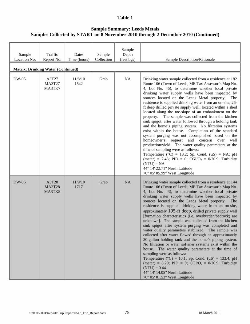
Table 1
Sample Summary: Leeds Metals Samples Collected by START on 8 November 2010 through 2 December 2010 (Continued)
S:\09050004\Reports\Trip Report\0547_Trip_Report.docx 75 18 March 2011
Sample Location No.
Traffic Report No.
Date/ Time (hours)
Sample Collection
Sample Depth
(feet bgs) Sample Description/Rationale
Matrix: Drinking Water (Continued)
DW-05 A3T27 MA3T27 MA3TK7
11/8/10 1542
Grab NA Drinking water sample collected from a residence at 182 Route 106 (Town of Leeds, ME Tax Assessor’s Map No. 4, Lot No. 46), to determine whether local private drinking water supply wells have been impacted by sources located on the Leeds Metal property. The residence is supplied drinking water from an on-site, 26-ft deep drilled private supply well, located within a shed located along the toe-slope of an embankment on the property. The sample was collected from the kitchen sink spigot, after water followed through a holding tank and the home’s piping system. No filtration systems exist within the house. Completion of the standard system purging was not accomplished based on the homeowner’s request and concern over well production/yield. The water quality parameters at the time of sampling were as follows: Temperature (°C) = 13.2; Sp. Cond. (µS) = NA; pH (meter) = 7.48; PID = 0; CGI/O2 = 0/20.9; Turbidity (NTU) = NA 44° 14′ 22.71″ North Latitude 70° 05′ 05.99″ West Longitude
DW-06 A3T28 MA3T28 MA3TK8
11/9/10 1717
Grab NA Drinking water sample collected from a residence at 144 Route 106 (Town of Leeds, ME Tax Assessor’s Map No. 4, Lot No. 43), to determine whether local private drinking water supply wells have been impacted by sources located on the Leeds Metal property. The residence is supplied drinking water from an on-site, approximately 195-ft deep, drilled private supply well [formation characteristics (i.e. overburden/bedrock) are unknown]. The sample was collected from the kitchen sink spigot after system purging was completed and water quality parameters stabilized. The sample was collected after water flowed through an approximately 30-gallon holding tank and the home’s piping system. No filtration or water softener systems exist within the house. The water quality parameters at the time of sampling were as follows: Temperature (°C) = 10.1; Sp. Cond. (µS) = 133.4; pH (meter) = 8.29; PID = 0; CGI/O2 = 0/20.9; Turbidity (NTU) = 0.44 44° 14′ 14.05″ North Latitude 70° 05′ 01.53″ West Longitude
Table 1
Sample Summary: Leeds Metals Samples Collected by START on 8 November 2010 through 2 December 2010 (Continued)
S:\09050004\Reports\Trip Report\0547_Trip_Report.docx 76 18 March 2011
Sample Location No.
Traffic Report No.
Date/ Time (hours)
Sample Collection
Sample Depth
(feet bgs) Sample Description/Rationale
Matrix: Drinking Water (Continued)
DW-08 A3T30 MA3T30 MA3TL0
11/17/10 1144
Grab NA Drinking water sample collected from a residence at 53 Blue Rock Road (Town of Monmouth, ME Tax Assessor’s Map No. 20, Lot No. 2-1), to determine whether local private drinking water supply wells have been impacted by sources located on the Leeds Metal property. The residence is supplied drinking water from an on-site, 120-ft deep, overburden private supply well located west of the house, within a concrete bunker. The sample was collected from an outside spigot after system purging was completed and water quality parameters stabilized. The sample was collected after water flowed through a holding tank and prior to a filtration system within the house. The water quality parameters at the time of sampling were as follows: Temperature (°C) = 9.7; Sp. Cond. (µS) = 63.7; pH (meter) = 6.73; PID = 0; CGI/O2 = 0/20.9; Turbidity (NTU) = 13.0 44° 14′ 29.69″ North Latitude 70° 05′ 24.99″ West Longitude
DW-09 (MS/MSD)
A3T31 MA3T31 MA3TL1
11/8/10 1645
Grab NA Drinking water sample collected from a residence at 105 Route 106 (Town of Leeds, ME Tax Assessor’s Map No. 4, Lot No. 39), to determine whether local private drinking water supply wells have been impacted by sources located on the Leeds Metal property. The residence is supplied drinking water from an on-site, approximately 222-ft deep drilled bedrock private supply well. The sample was collected from an inside spigot in the basement, after system purging was completed and water quality parameters stabilized. The sample was collected prior to a holding tank and sediment filter. The water quality parameters at the time of sampling were as follows: Temperature (°C) = 9.1; Sp. Cond. (µS) = 146.6; pH (meter) = 8.70; PID = 0; CGI/O2 = 0/20.9; Turbidity (NTU) = 0.22 44° 14′ 05.44″ North Latitude 70° 04′ 55.41″ West Longitude

Table 1
Sample Summary: Leeds Metals Samples Collected by START on 8 November 2010 through 2 December 2010 (Continued)
S:\09050004\Reports\Trip Report\0547_Trip_Report.docx 77 18 March 2011
Sample Location No.
Traffic Report No.
Date/ Time (hours)
Sample Collection
Sample Depth
(feet bgs) Sample Description/Rationale
Matrix: Drinking Water (Continued)
DW-10 A3T32 MA3T32 MA3TL2
11/8/10 1540
Grab NA Drinking water sample collected from a residence at 13 Young’s Drive (Town of Leeds, ME Tax Assessor’s Map No. 1, Lot No. 67-3) to determine whether local private drinking water supply wells have been impacted by sources located on the Leeds Metal property. The residence is supplied drinking water from an on-site 127-ft drilled gravel packed overburden private supply well. The sample was collected from an outside spigot after system purging was completed and water quality parameters stabilized. The sample was collected after water flowed through a holding tank. The water softener was bypassed by START for the purposes of sample collection. No filtration systems exist within the house. The water quality parameters at the time of sampling were as follows: Temperature (°C) = 11.7; Sp. Cond. (µS) = 209.0; pH (meter) = 7.58; PID = 0; CGI/O2 = 0/21.1; Turbidity (NTU) = 1.82 44° 14′ 06.81″ North Latitude 70° 05′ 02.21″ West Longitude
DW-11 A3T33 MA3T33 MA3TL3
11/10/10 1630
Grab NA Drinking water sample collected from a residence at 16 Young’s Drive (Town of Leeds, ME Tax Assessor’s Map No. 1, Lot No. 67-4), to determine whether local private drinking water supply wells have been impacted by sources located on the Leeds Metal property. The residence is supplied drinking water from an on-site, 137-ft deep, drilled overburden private supply well. The sample was collected from a basement spigot utilizing a spigot adapter, after system purging was completed and water quality parameters stabilized. The sample was collected after water flowed through an approximately 20-gallon holding tank. No filtration or treatment systems exist within the house. The water quality parameters at the time of sampling were as follows: Temperature (°C) = 9.5; Sp. Cond. (µS) = 200.9; pH (meter) = 7.94; PID = 0; CGI/O2 = 0/20.8; Turbidity (NTU) = 0.17 44° 13′ 57.82″ North Latitude 70° 04′ 56.18″ West Longitude

Table 1
Sample Summary: Leeds Metals Samples Collected by START on 8 November 2010 through 2 December 2010 (Continued)
S:\09050004\Reports\Trip Report\0547_Trip_Report.docx 78 18 March 2011
Sample Location No.
Traffic Report No.
Date/ Time (hours)
Sample Collection
Sample Depth
(feet bgs) Sample Description/Rationale
Matrix: Drinking Water (Continued)
DW-12 A3T34 MA3T34 MA3TL4
11/17/10 1617
Grab NA Drinking water sample collected from a residence at 4 Young’s Drive (Town of Leeds, ME Tax Assessor’s Map No. 1, Lot No. 67-1), to determine whether local private drinking water supply wells have been impacted by sources located on the Leeds Metal property. The residence is supplied drinking water from an on-site 160-ft deep drilled bedrock private supply well. The sample was collected from a basement spigot after system purging was completed and water quality parameters stabilized. The sample was collected after water flowed through an approximately 20-gallon holding tank. The homeowner reported that the residence had a filter system; however, the system was not used. PL Kelly noted a sulfur-like odor during the purging of the system. The water quality parameters at the time of sampling were as follows: Temperature (°C) = 8.8; Sp. Cond. (µS) = 243.1; pH (meter) = 8.14; PID = 0; CGI/O2 = 0/20.9; Turbidity (NTU) = 0.04 44° 14′ 04.21″ North Latitude 70° 04′ 59.46″ West Longitude
DW-13 A3T35 MA3T35 MA3TL5
11/8/10 1230
Grab NA Drinking water sample collected from a residence at 94 Route 106 (Town of Leeds, ME Tax Assessor’s Map No. 1, Lot No. 67-A), to determine whether local private drinking water supply wells have been impacted by sources located on the Leeds Metal property. The residence is supplied drinking water from an on-site, approximately 187-ft deep drilled bedrock private supply well. The sample was collected from the kitchen sink spigot after system purging was completed and water quality parameters stabilized. The sample was collected after water flowed through an approximately 30-gallon holding tank and the home’s piping system. The sediment filter on the system was no longer in service. The water quality parameters at the time of sampling were as follows: Temperature (°C) = 8.9; Sp. Cond. (µS) = 176.8; pH (meter) = 8.10; PID = 0; CGI/O2 = 0/20.9; Turbidity (NTU) = 0.16 44° 14′ 00.46″ North Latitude 70° 04′ 58.51″ West Longitude

Table 1
Sample Summary: Leeds Metals Samples Collected by START on 8 November 2010 through 2 December 2010 (Continued)
S:\09050004\Reports\Trip Report\0547_Trip_Report.docx 79 18 March 2011
Sample Location No.
Traffic Report No.
Date/ Time (hours)
Sample Collection
Sample Depth
(feet bgs) Sample Description/Rationale
Matrix: Drinking Water (Continued)
DW-14 A3T36 MA3T36 MA3TL6
11/8/10 1435
Grab NA Drinking water sample collected from a residence at 86 Route 106 (Town of Leeds, ME Tax Assessor’s Map No. 1, Lot No. 66), to determine whether local private drinking water supply wells have been impacted by sources located on the Leeds Metal property. The residence is supplied drinking water from an on-site, 18-ft deep dug well. The sample was collected from the kitchen sink spigot after system purging was completed and water quality parameters stabilized. The sample was collected after water flowed through a holding tank and the home’s piping system. The house’s filtration system was bypassed. The water quality parameters at the time of sampling were as follows: Temperature (°C) = 12.2; Sp. Cond. (µS) = 117.0; pH (meter) = 6.02; PID = 0; CGI/O2 = 0/20.9; Turbidity (NTU) =0.54 44° 13′ 59.02″ North Latitude 70° 05′ 01.80″ West Longitude
DW-15 A3T37 MA3T37 MA3TL7
11/16/10 1618
Grab NA Drinking water sample was collected from a residence at 97 Route 106 (Town of Leeds, ME Tax Assessor’s Map No. 1, Lot No. 58-8), to determine whether local private drinking water supply wells have been impacted by sources located on the Leeds Metal property. The residence is supplied drinking water from an on-site, approximately 90- to 100-ft deep, gravel-pack overburden private supply well. The sample was collected from a basement spigot after system purging was completed and water quality parameters stabilized. The samples were collected after water flowed through an approximately 20-gallon holding tank and prior to a sediment filtration system. The water quality parameters at the time of sampling were as follows: Temperature (°C) = 8.5; Sp. Cond. (µS) = 159.5; pH (meter) = 8.46; PID = 0; CGI/O2 = 0/20.7; Turbidity (NTU) =0.50 44° 14′ 03.02″ North Latitude 70° 04′ 54.98″ West Longitude

Table 1
Sample Summary: Leeds Metals Samples Collected by START on 8 November 2010 through 2 December 2010 (Continued)
S:\09050004\Reports\Trip Report\0547_Trip_Report.docx 80 18 March 2011
Sample Location No.
Traffic Report No.
Date/ Time (hours)
Sample Collection
Sample Depth
(feet bgs) Sample Description/Rationale
Matrix: Drinking Water (Continued)
DW-16 A3T38 MA3T38 MA3TL8
11/18/10 1835
Grab NA Drinking water sample collected from a residence at 91 Route 106 (Town of Leeds, ME Tax Assessor’s Map No. 1, Lot No. 58-7), to determine whether local private drinking water supply wells have been impacted by sources located on the Leeds Metal property. The residence is supplied drinking water from an on-site 198-ft deep drilled bedrock private supply well. The sample was collected from an inside basement spigot after system purging was completed and water quality parameters stabilized. The sample was collected after water flowed through a holding tank. No filtration or water softener systems were observed in the house. The water quality parameters at the time of sampling were as follows: Temperature (°C) = 11.7; Sp. Cond. (µS) = 146.5; pH (meter) = 8.40; PID = 0; CGI/O2 = 0/20.9; Turbidity (NTU) =1.67 44° 14′ 01.46″ North Latitude 70° 04′ 56.38″ West Longitude
DW-18 A3T40 MA3T40 MA3TM0
11/10/10 1742
Grab NA Drinking water sample collected from a residence at 83 Route 106 (Town of Leeds, ME Tax Assessor’s Map No. 1, Lot No. 58-5), to determine whether local private drinking water supply wells have been impacted by sources located on the Leeds Metal property. The residence is supplied drinking water from an on-site 220-ft deep drilled bedrock private supply well. The sample was collected from the kitchen sink spigot after system purging was completed and water quality parameters stabilized. The sample was collected after water flowed through an approximately 20-gallon holding tank and the home’s piping system, and prior to any filtration system. The water quality parameters at the time of sampling were as follows: Temperature (°C) = 9.0; Sp. Cond. (µS) = 189.4; pH (meter) = 8.31; PID = 0; CGI/O2 = 0/20.8; Turbidity (NTU) =1.43 44° 14′ 05.20″ North Latitude 70° 05′ 04.08″ West Longitude
Table 1
Sample Summary: Leeds Metals Samples Collected by START on 8 November 2010 through 2 December 2010 (Continued)
S:\09050004\Reports\Trip Report\0547_Trip_Report.docx 81 18 March 2011
Sample Location No.
Traffic Report No.
Date/ Time (hours)
Sample Collection
Sample Depth
(feet bgs) Sample Description/Rationale
Matrix: Drinking Water (Continued)
DW-19 A3T41 MA3T41 MA3TM1
11/17/10 1232
Grab NA Drinking water sample collected from a residence at 73 Route 106 (Town of Leeds, ME Tax Assessor’s Map No. 1, Lot No. 58-4), to determine whether local private drinking water supply wells have been impacted by sources located on the Leeds Metal property. The residence is supplied drinking water from an on-site, 12-ft deep, dug overburden private supply well. The sample was collected from an outside spigot after system purging was completed and water quality parameters stabilized. The sample was collected after water flowed through a holding tank and the home’s piping system, prior to any known filtration systems. The water quality parameters at the time of sampling were as follows: Temperature (°C) = 10.9; Sp. Cond. (µS) = 131.9; pH (meter) = 6.00; PID=NA; CGI/O2 = NA; Turbidity (NTU) = 0.49 44° 13′ 57.54″ North Latitude 70° 04′ 55.53″ West Longitude
DW-20 A3T42 MA3T42 MA3TM2
11/8/10 1658
Grab NA Drinking water sample collected from a residence at 67 Route 106 (Town of Leeds, ME Tax Assessor’s Map No. 1, as Lot No. 58-3), to determine whether local private drinking water supply wells have been impacted by sources located on the Leeds Metal property. The residence is supplied drinking water from an on-site, 16-ft deep, dug overburden private supply well. The sample was collected from a basement spigot after system purging was completed and water quality parameters stabilized. The sample was collected after water flowed through an approximately 30-gallon holding tank. The sample was collected prior to an in-line filtration system. The water quality parameters at the time of sampling were as follows: Temperature (°C) = 11.0; Sp. Cond. (µS) = 173.1; pH (meter) = 6.42; PID = 0; CGI/O2 = 0/21.0; Turbidity (NTU) =48.19 44° 13′ 54.23″ North Latitude 70° 04′ 55.29″ West Longitude

Table 1
Sample Summary: Leeds Metals Samples Collected by START on 8 November 2010 through 2 December 2010 (Continued)
S:\09050004\Reports\Trip Report\0547_Trip_Report.docx 82 18 March 2011
Sample Location No.
Traffic Report No.
Date/ Time (hours)
Sample Collection
Sample Depth
(feet bgs) Sample Description/Rationale
Matrix: Drinking Water (Continued)
DW-21 (MS/MSD)
A3T43 MA3T43 MA3TM3
11/17/10 0935
Grab NA Drinking water sample collected from a residence at 51 Blue Rock Road (Town of Monmouth, ME Tax Assessor’s Map No. 20, Lot No. 2), to determine whether local private drinking water supply wells have been impacted by sources located on the Leeds Metal property. The residence is supplied drinking water from an on-site 32-ft drilled overburden private supply well. The sample was collected from the kitchen sink spigot after system purging was completed and water quality parameters stabilized. The sample was collected after water flowed through an approximately 20-gallon holding tank and the home’s piping system. No filtration systems exist in the house. The water quality parameters at the time of sampling were as follows: Temperature (°C) = 10.3; Sp. Cond. (µS) = 59.8; pH (meter) = 6.13; PID = 0; CGI/O2 = 0/20.9; Turbidity (NTU) = 3.82 44° 14′ 16.13″ North Latitude 70° 04′ 55.37″ West Longitude
DW-22 A3T44 MA3T44 MA3TM4
11/8/10 1748
Grab NA Drinking water sample collected from a residence at 61 Route 106 (Town of Leeds, ME Tax Assessor’s Map No. 1, Lot No. 58-2), to determine whether local private drinking water supply wells have been impacted by sources located on the Leeds Metal property. The residence is supplied drinking water from an on-site dug private supply well (depth unknown). The sample was collected from an inside basement spigot utilizing a spigot adapter, after system purging was completed and water quality parameters stabilized. The sample was collected after water flowed through a holding tank. No filtration systems are known by START to exist within the house. The water quality parameters at the time of sampling were as follows: Temperature (°C) = 11.8; Sp. Cond. (µS) = 152.5; pH (meter) = 6.13; PID = 0; CGI/O2 = 0/20.9; Turbidity (NTU) = 0.86 44° 13′ 53.90″ North Latitude 70° 04′ 55.37″ West Longitude

Table 1
Sample Summary: Leeds Metals Samples Collected by START on 8 November 2010 through 2 December 2010 (Continued)
S:\09050004\Reports\Trip Report\0547_Trip_Report.docx 83 18 March 2011
Sample Location No.
Traffic Report No.
Date/ Time (hours)
Sample Collection
Sample Depth
(feet bgs) Sample Description/Rationale
Matrix: Drinking Water (Continued)
DW-23 A3T45 MA3T45 MA3TM5
11/16/10 1802
Grab NA Drinking water sample collected from a residence at 66 Route 106 (Town of Leeds, ME Tax Assessor’s Map No. 1, Lot No. 63), to determine whether local private drinking water supply wells have been impacted by sources located on the Leeds Metal property. The residence is supplied drinking water from an on-site, 497-ft deep, drilled bedrock private supply well. The sample was collected from an inside spigot after system purging was completed and water quality parameters stabilized. The sample was collected prior to an approximately 30-gallon holding tank and two sediment filters. The water quality parameters at the time of sampling were as follows: Temperature (°C) = 9.0; Sp. Cond. (µS) = 167.1; pH (meter) = 8.45; PID = 0; CGI/O2 = 0/20.7; Turbidity (NTU) = 0.95 44° 13′ 53.62″ North Latitude 70° 04′ 58.44″ West Longitude
DW-24 A3T46 MA3T46 MA3TM6
11/9/10 1225
Grab NA Drinking water sample collected from a residence at 60 Route 106 (Town of Leeds, ME Tax Assessor’s Map No. 1, Lot No. 63-2), to determine whether local private drinking water supply wells have been impacted by sources located on the Leeds Metal property. The residence is supplied drinking water from an on-site, approximately 375- to 400-ft deep, drilled bedrock private supply well. The sample was collected from an outdoor spigot after system purging was completed and water quality parameters stabilized. The sample was collected after water flowed through a 40-gallon holding tank and the home’s piping system. The water softener system was bypassed for sample collection purposes. The water quality parameters at the time of sampling were as follows: Temperature (°C) = 10.1; Sp. Cond. (µS) = 168.1; pH (meter) = 8.6; PID = 0; CGI/O2 = 0/20.9; Turbidity (NTU) = NA 44° 13′ 52.74″ North Latitude 70° 04′ 58.84″ West Longitude

Table 1
Sample Summary: Leeds Metals Samples Collected by START on 8 November 2010 through 2 December 2010 (Continued)
S:\09050004\Reports\Trip Report\0547_Trip_Report.docx 84 18 March 2011
Sample Location No.
Traffic Report No.
Date/ Time (hours)
Sample Collection
Sample Depth
(feet bgs) Sample Description/Rationale
Matrix: Drinking Water (Continued)
DW-25 A3T47 MA3T47 MA3TM7
11/8/10 1754
Grab NA Drinking water sample collected from a residence at 52 Route 106 (Town of Leeds, ME Tax Assessor’s Map No. 1, Lot No. 63-1), to determine whether local private drinking water supply wells have been impacted by sources located on the Leeds Metal property. The residence is supplied drinking water from an on-site 368-ft deep drilled bedrock private supply well. The sample was collected from a basement spigot after system purging was completed and water quality parameters stabilized. The sample was collected after water flowed through an approximately 25-gallon holding tank, and prior to a filter system. The water quality parameters at the time of sampling were as follows: Temperature (°C) = 9.0; Sp. Cond. (µS) = 161.3; pH (meter) = 8.73; PID = 0.1; CGI/O2 = 0/21.0; Turbidity (NTU) =1.58 44° 13′ 51.28″ North Latitude 70° 04′ 57.17″ West Longitude
DW-26 A3T48 MA3T48 MA3TM8
11/17/10 1648
Grab NA Drinking water sample collected from a residence at 45 Lowmoore Drive (Town of Leeds, ME Tax Assessor’s Map No. 1, Lot No. 57-5), to determine whether local private drinking water supply wells have been impacted by sources located on the Leeds Metal property. The residence is supplied drinking water from an on-site 700-ft deep drilled bedrock private supply well. The sample was collected from an outside spigot after system purging was completed and water quality parameters stabilized per START protocols. The sample was collected after water flowed through an approximately 20- to 25-gallon holding tank and the home’s piping system. No filtration systems exist within the house. The water quality parameters at the time of sampling were as follows: Temperature (°C) = 9.9; Sp. Cond. (µS) = 197.8; pH (meter) = 8.77; PID = 0; CGI/O2 = NA; Turbidity (NTU) = 0.70 44° 13′ 54.72″ North Latitude 70° 04′ 43.98″ West Longitude
Table 1
Sample Summary: Leeds Metals Samples Collected by START on 8 November 2010 through 2 December 2010 (Continued)
S:\09050004\Reports\Trip Report\0547_Trip_Report.docx 85 18 March 2011
Sample Location No.
Traffic Report No.
Date/ Time (hours)
Sample Collection
Sample Depth
(feet bgs) Sample Description/Rationale
Matrix: Drinking Water (Continued)
DW-27 A3T49 MA3T49 MA3TM9
11/11/10 1005
Grab NA Drinking water sample collected from a residence at 6 Ashley Lane (Town of Leeds, ME Tax Assessor’s Map No. 1, Lot No. 57-3), to determine whether local private drinking water supply wells have been impacted by sources located on the Leeds Metal property. The residence is supplied drinking water from an on-site 400-ft deep drilled (assumed bedrock) private supply well. The sample was collected from an outside spigot after system purging was completed and water quality parameters stabilized. The sample was collected after water flowed through an approximately 20- to 25-gallon holding tank and the home’s piping system. No filtration systems exist at the house. The water quality parameters at the time of sampling were as follows: Temperature (°C) = 9.4; Sp. Cond. (µS) = 202.0; pH (meter) = 8.93; PID = 0; CGI/O2 = 0/20.9; Turbidity = 1.49 44° 13′ 57.20″ North Latitude 70° 04′ 41.40″ West Longitude
DW-28 A3T50 MA3T50 MA3TN0
11/9/10 1832
Grab NA Drinking water sample collected from a residence at 26 Lowmoore Drive (Town of Leeds, ME Tax Assessor’s Map No. 1, Lot No. 57-7), to determine whether local private drinking water supply wells have been impacted by sources located on the Leeds Metal property. The residence is supplied drinking water from on-site 130-ft deep drilled private supply well [formation characteristics (i.e. overburden/bedrock) are unknown]. The sample was collected from the kitchen sink spigot after system purging was completed and water quality parameters stabilized. The sample was collected after water flowed through a holding tank and the home’s piping system. No filtration system exists in the house. The water quality parameters at the time of sampling were as follows: Temperature (°C) = 9.6; Sp. Cond. (µS) = 209.6; pH (meter) = 8.57; PID = NA; CGI/O2 = NA; Turbidity (NTU) = 1.11 44° 13′ 51.01″ North Latitude 70° 04′ 41.57″ West Longitude

Table 1
Sample Summary: Leeds Metals Samples Collected by START on 8 November 2010 through 2 December 2010 (Continued)
S:\09050004\Reports\Trip Report\0547_Trip_Report.docx 86 18 March 2011
Sample Location No.
Traffic Report No.
Date/ Time (hours)
Sample Collection
Sample Depth
(feet bgs) Sample Description/Rationale
Matrix: Drinking Water (Continued)
DW-29 A3T51 MA3T51 MA3TN1
11/9/10 1804
Grab NA Drinking water sample collected from a residence at 33 Route 106 (Town of Leeds, ME Tax Assessor’s Map No. 1, Lot No. 59-2), to determine whether local private drinking water supply wells have been impacted by sources located on the Leeds Metal property. The residence is supplied drinking water from an on-site, dug overburden private supply well of unknown depth. The sample was collected from an outside spigot after system purging was completed and water quality parameters stabilized. The sample was collected after water flowed through an approximately 15-gallon holding tank on well housing. The residence does not have a filtration system. The water quality parameters at the time of sampling were as follows: Temperature (°C) = 11.0; Sp. Cond. (µS) = 190.1; pH (meter) = 6.45; PID = NA; CGI/O2 = NA; Turbidity (NTU) =1.23 44° 13′ 46.17″ North Latitude 70° 04′ 51.74″ West Longitude
DW-30 A3T52 MA3T52 MA3TN2
11/8/10 1920
Grab NA Drinking water sample collected from a residence at 11 Route 106 (Town of Leeds, ME Tax Assessor’s Map No. 1, Lot No. 59), to determine whether local private drinking water supply wells have been impacted by sources located on the Leeds Metal property. The residence is supplied drinking water from an on-site drilled private supply well [well depth and formation characteristics (i.e. overburden/bedrock) are unknown]. The sample was collected from an in-line spigot in the basement, immediately after water enters the home’s piping system. The sample was collected prior to a holding tank, after system purging was completed and water quality parameters stabilized. The homeowner stated that he had bypassed the filtration systems and water softener. The water quality parameters at the time of sampling were as follows: Temperature (°C) = 9.8; Sp. Cond. (µS) = 176.8; pH (meter) = 9.40; PID = NA; CGI/O2 = NA; Turbidity (NTU) = 0.19 44° 13′ 40.08″ North Latitude 70° 04′ 54.43″ West Longitude

Table 1
Sample Summary: Leeds Metals Samples Collected by START on 8 November 2010 through 2 December 2010 (Continued)
S:\09050004\Reports\Trip Report\0547_Trip_Report.docx 87 18 March 2011
Sample Location No.
Traffic Report No.
Date/ Time (hours)
Sample Collection
Sample Depth
(feet bgs) Sample Description/Rationale
Matrix: Drinking Water (Concluded)
DW-31 A3T53 MA3T53 MA3TN3
11/17/10 1321
Grab NA Drinking water sample collected from a residence at 53 Route 106 (Town of Leeds, ME Tax Assessor’s Map No. 1, Lot No. 58-1), to determine whether local private drinking water supply wells have been impacted by sources located on the Leeds Metal property. The residence is supplied drinking water from an on-site 12 foot deep dug overburden private supply well. The sample was collected from an outside spigot after system purging was completed and water quality parameters stabilized. Homeowner was not available; START assumes sample collected after a holding tank and that not filtration system exists. The water quality parameters at the time of sampling were as follows: Temperature (°C) = 12.7; Sp. Cond. (µS) = 232.6; pH = 6.39; PID = NA; CGI/O2 = NA; Turbidity (NTU) = 0.22 44° 13′ 51.04″ North Latitude 70° 04′ 54.83″ West Longitude
DW-33 A3T55 MA3T55 MA3TN5
11/8/10 1435
Grab NA Field Duplicate of DW-14, collected for quality control.
DW-34 A3T56 MA3T56 MA3TN6
11/16/10 1618
Grab NA Field duplicate of DW-15, collected for quality control.
MATRIX: Sediment
SD-01 A3T67 MA3T67
11/16/10 1000
Grab 0 to 1 Sediment sample collected using a hand auger from Island Pond, northwest of the Leeds Metal property, to document background/reference pond sediment conditions for comparison purposes. The material was dark brown, SANDY SILT and ORGANIC MATTER, some clay, trace gravel, saturated Cond. (µS/cm) = 42.4; Temp. (°C) = 7.0; Turbidity (NTU) = 0.42; pH (meter) = 7.26; PID/FID (units) = 24/0; CGI/O2 = 0/20.9; Color (water) = Clear; Other = Slight organic decay odor 44° 14′ 35.55″ North Latitude 70° 05′ 11.54″ West Longitude
Table 1
Sample Summary: Leeds Metals Samples Collected by START on 8 November 2010 through 2 December 2010 (Continued)
S:\09050004\Reports\Trip Report\0547_Trip_Report.docx 88 18 March 2011
Sample Location No.
Traffic Report No.
Date/ Time (hours)
Sample Collection
Sample Depth
(feet bgs) Sample Description/Rationale
MATRIX: Sediment (Continued)
SD-02 MA3T68 11/16/10 1010
Grab 0 to 1 Sediment sample collected using a hand auger from Island Pond, northwest of the Leeds Metal property, to document background/reference pond sediment conditions for comparison purposes (total metals analysis only). The material was dark brown, SANDY SILT and ORGANIC MATTER, some clay, trace gravel, saturated. Cond. (µS/cm) = 42.4; Temp. (°C) = 7.0; Turbidity (NTU) = 0.42; pH (meter) = 7.26; PID/FID (units) = 24/0; CGI/O2 = 0/20.9; Color (water) = Clear; Other = Slight organic decay odor 44° 14′ 35.86″ North Latitude 70° 05′ 11.29″ West Longitude
SD-03 A3T69 MA3T69
11/16/10 1215
Grab 0 to 1 Sediment sample collected using a hand auger from a wetland area located along Blue Rock Road, east of the Leeds Metal property, to document background wetland sediment conditions for comparison purposes. The material was dark brown, SILT and CLAY, major organic material, trace fine-to-medium sand, saturated. Cond.(µS/cm) = 41.7; Temp. (°C) = 6.0; Turbidity (NTU) = 1.28; pH (meter) = 6.02; PID/FID (units) = 17/0; CGI/O2 = 0/20.9; Color (water) = Yellow; Other = None 44° 14′ 15.45″ North Latitude 70° 04′ 24.04″ West Longitude
SD-04 MA3T70 11/16/10 1220
Grab 0 to 1 Sediment sample collected using a hand auger from a wetland area located along Blue Rock Road, east of the Leeds Metal property, to document background wetland sediment conditions for comparison purposes (total metals analysis only). The material was dark brown, SILT and CLAY, major organic material, trace fine-to-medium sand, saturated. Cond. (µS/cm) = 41.7; Temp. (°C) = 6.0; Turbidity (NTU) = 1.28; pH (meter) = 6.02; PID/FID (units) = 17/0; CGI/O2 = 0/20.9; Color (water) = yellow; Other = None 44° 14′ 15.45″ North Latitude 70° 04′ 24.04″ West Longitude
Table 1
Sample Summary: Leeds Metals Samples Collected by START on 8 November 2010 through 2 December 2010 (Continued)
S:\09050004\Reports\Trip Report\0547_Trip_Report.docx 89 18 March 2011
Sample Location No.
Traffic Report No.
Date/ Time (hours)
Sample Collection
Sample Depth
(feet bgs) Sample Description/Rationale
MATRIX: Sediment (Continued)
SD-05 (MS/MSD)
A3T71 MA3T71
11/9/10 1130
Grab 0 to 0.8 Sediment sample collected using a hand auger from the wetland located on the northwestern portion of the Leeds Metal property, to determine if a release of hazardous substances had occurred. The material was brown, fine-to-medium SAND, some silt, little organics, trace fine-to-coarse gravel, trace clay. Cond. (µS/cm) = 87.1; Temp. (°C) = 7.8; Turbidity (NTU) = 5.28; pH (meter) = 6.81; PID/FID (units) = 14/2; CGI/O2 = 0/21.0; Color (water) = Brown; Other = Strong organic decay odor 44° 14′ 14.71″ North Latitude 70° 04′ 56.88″ West Longitude
SD-06 A3T72 MA3T72
11/9/10 1204
Grab 0 to 1 Sediment sample collected using a hand auger from the wetland located on the northwestern portion of the Leeds Metal property, to determine if a release of hazardous substances had occurred. The material was dark brown, organic-rich SAND and SILT, trace fine-to-coarse gravel, trace clay, saturated. Cond. (µS/cm) = 75.0; Temp. (°C) = 7.3; Turbidity (NTU) = 1.49; pH (meter) = 6.98; PID/FID (units) = 20/1; CGI/O2 = 0/20.9; Color (water) = Clear; Other = Organic decay odor 44° 14′ 16.76″ North Latitude 70° 04′ 56.98″ West Longitude
SD-07 A3T73 MA3T73
11/9/10 1025
Grab 1 to 1.5 Sediment sample collected using a hand auger from the southern lagoon located on the northwestern portion of the Leeds Metal property, adjacent to an abandoned 55-gallon steel drum, to determine if a release of hazardous substances had occurred. The material was brown-to-dark brown, fine-to-coarse SAND and SILT, trace fine gravel, trace clay, trace organic matter. Cond. (µS/cm) = 91.9; Temp. (°C) = 7.3; Turbidity (NTU) = 2.74; pH (meter) = 6.95; PID/FID (units) = 9/0; CGI/O2 = 0/20.9; Color (water) = Clear; Other = Organic decay odor 44° 14′ 09.79″ North Latitude 70° 04′ 56.98″ West Longitude

Table 1
Sample Summary: Leeds Metals Samples Collected by START on 8 November 2010 through 2 December 2010 (Continued)
S:\09050004\Reports\Trip Report\0547_Trip_Report.docx 90 18 March 2011
Sample Location No.
Traffic Report No.
Date/ Time (hours)
Sample Collection
Sample Depth
(feet bgs) Sample Description/Rationale
MATRIX: Sediment (Continued)
SD-08 A3T74 MA3T74
11/9/10 1105
Grab 0 to 0.7 Sediment sample collected using a hand auger from the northern lagoon located on the northwestern portion of the Leeds Metal property, to determine if a release of hazardous substances had occurred. The material was dark brown, fine-to-medium SAND, some organic matter, little fine gravel, trace clay. Cond. (µS/cm) = 94.5; Temp. (°C) = 6.5; Turbidity (NTU) = 2.00; pH (meter) = 7.1; PID/FID (units) = 42/4; CGI/O2 = 0/21.1; Color (water) = Brown; Other = Petroleum odor and slight sheen 44° 14′ 14.18″ North Latitude 70° 04′ 55.48″ West Longitude
SD-09 A3T75 MA3T75
11/9/10 0950
Grab 0.5 to 1 Sediment sample collected using a hand auger from the southern lagoon located on the northwestern portion of the Leeds Metal property, to determine if a release of hazardous substances had occurred. The material was dark brown, fine SAND and SILT, trace medium-to-coarse sand, trace fine trace gravel, trace clay, trace organics, saturated. Cond. (µS/cm) = 131.5; Temp. (°C) = 5.9; Turbidity (NTU) = 4.15; pH (meter) = 7.81; PID/FID (units) = 14/0; CGI/O2 = 0/20.9; Color (water) = Clear; Other = None 44° 14′ 16.34″ North Latitude 70° 04′ 53.18″ West Longitude
SD-10 A3T76 MA3T76
11/9/10 1240
Grab 0 to 0.7 Sediment sample collected using a hand auger from the eastern side of the on-site pond located in the central portion of the Leeds Metal property, to determine if a release of hazardous substances had occurred. The material was brown, SILT, trace fine-to-coarse sand, trace fine gravel, trace organics, trace clay, trace debris (wire coating). Cond. (µS/cm) = 176.6; Temp. (°C) = 6.0; Turbidity (NTU) = 4.56; pH (meter) = 7.45; PID/FID (units) = 0/0; CGI/O2 = 0/21.1; Color (water) = Clear; Other = Organic decay odor 44° 14′ 13.27″ North Latitude 70° 04′ 49.90″ West Longitude

Table 1
Sample Summary: Leeds Metals Samples Collected by START on 8 November 2010 through 2 December 2010 (Continued)
S:\09050004\Reports\Trip Report\0547_Trip_Report.docx 91 18 March 2011
Sample Location No.
Traffic Report No.
Date/ Time (hours)
Sample Collection
Sample Depth
(feet bgs) Sample Description/Rationale
MATRIX: Sediment (Continued)
SD-11 A3T77 MA3T77
11/15/10 1605
Grab 0 to 0.7 Sediment sample collected using a hand auger from the wetland area located south of (adjacent to) the Leeds Metal property, to determine if a release of hazardous substances had occurred. The material was brown, SILT and CLAY, trace organics, trace fine-to-coarse sand, trace fine gravel, saturated. Cond. (µS/cm) = 22.7; Temp. (°C) = 6.3; Turbidity (NTU) = 16.9; pH (meter) = 5.58; PID/FID (units) = 34/0; CGI/O2 = 0/20.9; Color (water) = Brown; Other = None 44° 14′ 01.69″ North Latitude 70° 04′ 44.61″ West Longitude
SD-12 A3T78 MA3T78
11/15/10 1545
Grab 0 to 0.5 Sediment sample collected using a hand auger from the wetland area located south of (adjacent to) the Leeds Metal property, to determine if a release of hazardous substances had occurred. The material was brown, SILT and CLAY, little fine sand, trace organic matter, saturated. Cond. (µS/cm) = 24.1; Temp. (°C) = 5.3; Turbidity (NTU) = 97; pH (meter) = 4.24; PID/FID (units) = 5/0; CGI/O2 = 0/20.9; Color (water) = Brown; Other = Swampy 44° 14′ 04.21″ North Latitude 70° 04′ 43.39″ West Longitude
SD-13 A3T79 MA3T79
11/15/10 1515
Grab 0.5 to 1 Sediment sample collected using a hand auger from wetland area located south/adjacent to the Leeds Metal property, along the western side of the railroad tracks, to determine if a release of hazardous substances had occurred. The material was greenish-brown, fine SAND and SILT, trace clay, organics, and medium sand, saturated. Cond. (µS/cm) = 22.0; Temp. (°C) = 7.3; Turbidity (NTU) = 0.54; pH (meter) = 5.43; PID/FID (units) = 30/0; CGI/O2 = 0/20.9; Color (water) = Clear; Other = Organic/swamp 44° 14′ 07.48″ North Latitude 70° 04′ 41.69″ West Longitude

Table 1
Sample Summary: Leeds Metals Samples Collected by START on 8 November 2010 through 2 December 2010 (Continued)
S:\09050004\Reports\Trip Report\0547_Trip_Report.docx 92 18 March 2011
Sample Location No.
Traffic Report No.
Date/ Time (hours)
Sample Collection
Sample Depth
(feet bgs) Sample Description/Rationale
MATRIX: Sediment (Continued)
SD-14 A3T80 MA3T80
11/15/10 1400
Grab 0 to 1 Sediment sample collected using a hand auger from a downstream location along the Unnamed Stream, along the eastern side of the railroad tracks, to determine if a release of hazardous substances had occurred. The material was brown-to-dark brown, fine SAND and SILT, little clay, little organic matter, trace medium-to-coarse sand, saturated. Cond. (µS/cm) = 46.3; Temp. (°C) = 8.2; Turbidity (NTU) = NR; pH (meter) = 5.95; PID/FID (units) = 26/0; CGI/O2 = 0/20.9; Color (water) = Clear; Other = Sheen noted 44° 14′ 08.95″ North Latitude 70° 04′ 39.95″ West Longitude
SD-15 A3T81 MA3T81
11/15/10 1330
Grab 0 to 0.5 Sediment sample collected using a hand auger from a downstream location along the Unnamed Stream, east of the Leeds Metal property, to determine if a release of hazardous substances had occurred. The material was dark brown-to-black, SILT and CLAY, organic-rich, saturated. Cond. (µS/cm) = 33.9; Temp. (°C) = 5.6; Turbidity (NTU) = 2.79; pH (meter) = 5.98; PID/FID (units) = 9/0; CGI/O2 = 0/20.9; Color (water) = Clear; Other = None 44° 14′ 15.66″ North Latitude 70° 04′ 35.83″ West Longitude
SD-16 A3T82 MA3T82
11/15/10 1230
Grab 0 to 0.5 Sediment sample collected using a hand auger from a downstream location along the Unnamed Stream, adjacent to a culvert which directs surface water below Blue Rock Road, to determine if a release of hazardous substances had occurred. The material was light brown-to-brown, SAND, little fine-to-coarse gravel, trace silt, trace clay, trace debris (asphalt), saturated. Cond. (µS/cm) = 17.7; Temp. (°C) = 5.6; Turbidity (NTU) = 3.48; pH (meter) = 5.69; PID/FID (units) = 14/0; CGI/O2 = 0/20.9; Color (water) = Clear; Other = None 44° 14′ 19.46″ North Latitude 70° 04′ 34.06″ West Longitude
Table 1
Sample Summary: Leeds Metals Samples Collected by START on 8 November 2010 through 2 December 2010 (Continued)
S:\09050004\Reports\Trip Report\0547_Trip_Report.docx 93 18 March 2011
Sample Location No.
Traffic Report No.
Date/ Time (hours)
Sample Collection
Sample Depth
(feet bgs) Sample Description/Rationale
MATRIX: Sediment (Continued)
SD-17 A3T83 MA3T83
11/15/10 1200
Grab 0 to 0.5 Sediment sample collected using a hand auger from a downstream location along the Unnamed Stream, northeast of the Leeds Metal property, to determine if a release of hazardous substances had occurred. The material was dark brown-to-black, organic-rich, SILT and CLAY, saturated. Cond. (µS/cm) = 25.1; Temp. (°C) = 5.9; Turbidity (NTU) = 3.12; pH (meter) = 6.01; PID/FID (units) = 23/0; CGI/O2 = 0/20.9; Color (water) = Clear; Other = None 44° 14′ 24.56″ North Latitude 70° 04′ 33.77″ West Longitude
SD-18 A3T84 MA3T84
11/15/10 1140
Grab 0 to 0.5 Sediment sample collected using a hand auger from Bonney Pond, downstream of the confluence with the Unnamed Stream and northeast of the Leeds Metal property, to determine if a release of hazardous substances had occurred. The material was dark brown-to-black, SILT and CLAY, major organic matter. Cond. (µS/cm) = 24.8; Temp. (°C) = 5.5; Turbidity (NTU) = 2.41; pH (meter) = 6.48; PID/FID (units) = 23/1; CGI/O2 = 0/20.9; Color (water) = Clear; Other = Sulfur odor and organic odor 44° 14′ 29.05″ North Latitude 70° 04′ 33.22″ West Longitude
SD-19 A3T85 MA3T85
11/8/10 1535
Grab 0.5 to 0.7 Sediment sample collected using a hand auger from a tributary converging with the Dead River No. 2, southwest of the Leeds Metal property, to document reference stream sediment conditions for comparison purposes. The material was dark brown, SILT and CLAY, major organic matter. Cond. (µS/cm) = 151.1; Temp. (°C) = 8.4; Turbidity (NTU) = 1.09; pH (meter) = 7.36; PID/FID (units) = 20/0; CGI/O2 = 0 /20.9; Color (water) = Clear; Other = Organic decay odor 44° 13′ 47.83″ North Latitude 70° 05′ 07.22″ West Longitude

Table 1
Sample Summary: Leeds Metals Samples Collected by START on 8 November 2010 through 2 December 2010 (Continued)
S:\09050004\Reports\Trip Report\0547_Trip_Report.docx 94 18 March 2011
Sample Location No.
Traffic Report No.
Date/ Time (hours)
Sample Collection
Sample Depth
(feet bgs) Sample Description/Rationale
MATRIX: Sediment (Continued)
SD-20 MA3T86 11/8/10 1535
Grab 0.5 to 0.7 Sediment sample collected using a hand auger from a tributary converging with the Dead River No. 2, southwest of the Leeds Metal property, to document reference stream sediment conditions for comparison purposes (total metals analysis only). The material was dark brown, major ORGANIC MATTER, silt and clay. Cond. (µS/cm) = 151.1; Temp. (°C) = 8.4; Turbidity (NTU) = 1.09; pH (meter) = 7.36; PID/FID (units) = 20/0; CGI/O2 = 0/20.9; Color (water) = Clear; Other = Organic decay odor 44° 13′ 47.83″ North Latitude 70° 05′ 07.22″ West Longitude
SD-21 A3T87 MA3T87
11/8/10 1450
Grab 0.5 to 1 Sediment sample collected using a hand auger from an upstream location along the Dead River No. 2, west of the Leeds Metal property, to document reference stream sediment conditions for comparison purposes. The material was brown-to-dark brown, fine SAND and SILT, trace organic matter, trace clay, saturated. Cond. (µS/cm) = 40.8; Temp. (°C) = 6.0; Turbidity (NTU) = 7.27; pH (meter) = 6.69; PID/FID (units) =2 /0; CGI/O2 = 0/20.9; Color (water) = Clear; Other = None 44° 13′ 53.27″ North Latitude 70° 05′ 12.48″ West Longitude
SD-22 MA3T88 11/8/10 1450
Grab 0.5 to 1 Sediment sample collected using a hand auger from an upstream location along the Dead River No. 2, west of the Leeds Metal property, to document reference stream sediment conditions for comparison purposes (total metals analysis only). The material was brown-to-dark brown, fine SAND and SILT, trace organic matter, trace clay, saturated. Cond. (µS/cm) = 40.8; Temp. (°C) = 6.0; Turbidity (NTU) = 7.27; pH (meter) = 6.69; PID/FID (units) = 2/0; CGI/O2 = 0/20.9; Color (water) = Clear; Other = None 44° 13′ 53.27″ North Latitude 70° 05′ 12.48″ West Longitude

Table 1
Sample Summary: Leeds Metals Samples Collected by START on 8 November 2010 through 2 December 2010 (Continued)
S:\09050004\Reports\Trip Report\0547_Trip_Report.docx 95 18 March 2011
Sample Location No.
Traffic Report No.
Date/ Time (hours)
Sample Collection
Sample Depth
(feet bgs) Sample Description/Rationale
MATRIX: Sediment (Continued)
SD-23 A3T89 MA3T89
11/8/10 1510
Grab 0.5 to 0.7 Sediment sample collected using a hand auger from immediately beneath a groundwater seep along an intermittent stream, prior to the stream’s convergence with the Dead River No. 2 (southwest of the Leeds Metal property), to determine if a release of hazardous substances had occurred. The material was gray, SILT and CLAY, trace organic matter, trace fine-to-medium sand. Cond. (µS/cm) = NR; Temp. (°C) = NR; Turbidity (NTU) = NR; pH (meter) = NR; PID/FID (units) = 13/0; CGI/O2 = 0/20.9; Color (water) = Clear; Other = none 44° 13′ 51.22″ North Latitude 70° 05′ 12.48″ West Longitude
SD-24 (MS/MSD)
A3T90 MA3T90
11/15/10 1555
Grab 0.4 to 1 Sediment sample collected using a hand auger from the northern edge of the wetland area located south of (adjacent to) the Leeds Metal property, to determine if a release of hazardous substances had occurred. The material was greenish-gray, CLAY, little silt, trace organic matter. Cond. (µS/cm) = 36.5; Temp. (°C) = 5.9; Turbidity (NTU) = 2.04; pH (meter) = 6.03; PID/FID (units) = 13/0; CGI/O2 = 0/20.9; Color (water) = Clear, slight brown tint; Other = Gray Sheen 44° 14′ 04.19″ North Latitude 70° 04′ 45.29″ West Longitude
SD-25 A3T91 MA3T91
11/8/10 1319
Grab 0.5 to 0.7 Sediment sample collected using a hand auger from the Dead River No. 2, at its confluence with a groundwater seep (southwest of the Leeds Metal property), to determine if a release of hazardous substances had occurred. The material was greenish-brown-to-dark brown, SILT, little clay, little organic matter, little fine sand. Cond. (µS/cm) = 41.7; Temp. (°C) = 5.7; Turbidity (NTU) = 6.42; pH (meter) = 6.78; PID/FID (units) = 18/0; CGI/O2 = 21/20.9; Color (water) = Clear; Other = Organic decay odor 44° 13′ 49.45″ North Latitude 70° 05′ 08.03″ West Longitude

Table 1
Sample Summary: Leeds Metals Samples Collected by START on 8 November 2010 through 2 December 2010 (Continued)
S:\09050004\Reports\Trip Report\0547_Trip_Report.docx 96 18 March 2011
Sample Location No.
Traffic Report No.
Date/ Time (hours)
Sample Collection
Sample Depth
(feet bgs) Sample Description/Rationale
MATRIX: Sediment (Continued)
SD-26 A3T92 MA3T92
11/8/10 1259
Grab 0.5 to 0.7 Sediment sample collected using a hand auger from a downstream location along the Dead River No. 2, southwest of the Leeds Metal property, to determine if a release of hazardous substances had occurred. The material was brown-to-dark greenish-brown, SILT, little fine sand, trace clay, saturated. Cond. (µS/cm) = 43.8; Temp. (°C) = 5.6; Turbidity (NTU) = 8.81; pH (meter) = 6.66; PID/FID (units) = 24/0; CGI/O2 = 0/20.9; Color (water) = Clear; Other = None 44° 13′ 47.73″ North Latitude 70° 05′ 06.39″ West Longitude
SD-27 A3T93 MA3T93
11/8/10 1242
Grab 0.5 to 0.7 Sediment sample collected using a hand auger from the most downstream sediment sampling location along the Dead River No. 2, southwest of the Leeds Metal property, to determine if a release of hazardous substances had occurred. The material was brown-to-dark brown, fine SAND and SILT, little organic matter, trace clay, trace medium-to-coarse sand. Cond. (µS/cm) = 43.7; Temp. (°C) = 5.6; Turbidity (NTU) = 9.95; pH (meter) = 7.41; PID/FID (units) = 5/0; CGI/O2 = 0/20.9; Color (water) = Brownish tint; Other = None 44° 13′ 45.81″ North Latitude 70° 05′ 05.98″ West Longitude
SD-28 A3T94 MA3T94
11/15/10 1315
Grab 0.5 to 1 Sediment sample collected using a hand auger from the southwestern boundary of the wetland area located south of the Leeds Metal property, to determine if a release of hazardous substances had occurred. The material was yellow-brown-to-brown, fine SAND and SILT, little clay, trace organic matter, trace medium-to-coarse sand. Cond. (µS/cm) = 77.3; Temp. (°C) = 5.3; Turbidity (NTU) = 0.11; pH (meter) = 6.18; PID/FID (units) = 0/0; CGI/O2 = 0/20.9; Color (water) = Clear, slight yellow tint; Other = Slight organic decay odor 44° 13′ 58.99″ North Latitude 70° 04′ 46.46″ West Longitude

Table 1
Sample Summary: Leeds Metals Samples Collected by START on 8 November 2010 through 2 December 2010 (Continued)
S:\09050004\Reports\Trip Report\0547_Trip_Report.docx 97 18 March 2011
Sample Location No.
Traffic Report No.
Date/ Time (hours)
Sample Collection
Sample Depth
(feet bgs) Sample Description/Rationale
MATRIX: Sediment (Continued)
SD-29 A3T95 MA3T95
11/15/10 1245
Grab 0.5 to 0.7 Sediment sample collected using a hand auger from a surface water channel flowing southwest from the wetland area located south of the Leeds Metal property, to determine if a release of hazardous substances had occurred. The material was dark brown-to-black, SILT and CLAY, major organic matter, trace fine-to-coarse sand, gelatinous, saturated. Cond. (µS/cm) = 70.5; Temp. (°C) = 6.8; Turbidity (NTU) = 1.12; pH (meter) = 6.2; PID/FID (units) = 16/0; CGI/O2 = 0/20.9; Color (water) = Clear; Other = Slight organic decay odor, brown organic debris in water. 44° 13′ 55.30″ North Latitude 70° 04′ 49.12″ West Longitude
SD-30 A3T96 MA3T96
11/9/10 1135
Grab 0 to 0.7 Sediment sample collected using a hand auger from the wetland located on the northwestern portion of the Leeds Metal property, to determine if a release of hazardous substances had occurred. The material was greenish-brown, fine-to-medium SAND, little silt, trace coarse sand, trace organic matter, trace fine gravel, trace clay. Cond. (µS/cm) = NR; Temp. (°C) = NR; Turbidity (NTU) = NR; pH (meter) = NR; PID/FID (units) = 15/0; CGI/O2 = 0/20.9; Color (water) = Clear; Other = None 44° 14′ 18.24″ North Latitude 70° 04′ 54.29″ West Longitude
SD-31 (MS/MSD)
A3T97 MA3T97
11/8/10 1420
Grab 0 to 1 Sediment sample collected using a hand auger from a downstream location along the Dead River No. 2, southwest of the Leeds Metal property, to determine if a release of hazardous substances had occurred. The material was brown-to-greenish brown, SILT, little clay, trace fine sand, trace organic matter. Cond. (µS/cm) = 40.8; Temp. (°C) = 5.9; Turbidity (NTU) = 8.45; pH (meter) = 6.85; PID/FID (units) = 28/0; CGI/O2 = 0/20.9; Color (water) = Clear; Other = None 44° 13′ 50.87″ North Latitude 70° 05′ 11.23″ West Longitude

Table 1
Sample Summary: Leeds Metals Samples Collected by START on 8 November 2010 through 2 December 2010 (Continued)
S:\09050004\Reports\Trip Report\0547_Trip_Report.docx 98 18 March 2011
Sample Location No.
Traffic Report No.
Date/ Time (hours)
Sample Collection
Sample Depth
(feet bgs) Sample Description/Rationale
MATRIX: Sediment (Concluded)
SD-32 A3T98 MA3T98
11/9/10 1240
Grab 0 to 0.7 Field duplicate of SD-10, collected for quality control.
SD-33 A3T99 MA3T99
11/15/10 1315
Grab 0.5 to 1 Field duplicate of SD-28, collected for quality control.
SD-34 A3TQ4 MA3TQ4
11/15/10 1140
Grab 0 to 1 Sediment sample collected using a hand auger immediately downstream of a 55-gallon steel drum, within the Unnamed Intermittent Stream located south of the Leeds Metal property, to determine if a release of hazardous substances had occurred. The material was yellowish-brown, fine-to-coarse SAND and SILT, some clay, little fine-to-coarse gravel, saturated. Cond. (µS/cm) = 72.2; Temp. (°C) = 6.3; Turbidity (NTU) = 0.15; pH (meter) = 6.8; PID/FID (units) = 24/0; CGI/O2 = 0/20.9; Color (water) = Clear, slight yellow tint; Other = None 44° 13′ 45.68″ North Latitude 70° 04′ 50.46″ West Longitude
MATRIX: Aqueous QA/QC
RB-01 A3TA0 MA3TA0 MA3TP7
11/8/10 1800
Grab NA Drinking water sampling equipment (spigot adapter) rinsate blank sample, collected for quality control.
RB-02 A3TA1 MA3TA1 MA3TP8
11/10/10 1730
Grab NA Drinking water sampling equipment (spigot adapter) rinsate blank sample, collected for quality control.
RB-03 A3TA2 MA3TA2 MA3TP9
11/10/10 1700
Grab NA Ground water sampling equipment (bladder pump) rinsate blank sample, collected for quality control.
RB-04 A3TA3 MA3TA3 MA3TQ0
11/11/10 1600
Grab NA Ground water sampling equipment (bladder pump) rinsate blank sample, collected for quality control.
RB-05 A3TA4 MA3TA4 MA3TQ1
11/16/10 1700
Grab NA Ground water sampling equipment (bladder pump) rinsate blank sample, collected for quality control.
RB-08 A3TA7 MA3TA7
11/8/10 1800
Grab NA Sediment sampling equipment (stainless steel hand auger, stainless steel bowl, and stainless steel scoop) rinsate blank sample, collected for quality control.

Table 1
Sample Summary: Leeds Metals Samples Collected by START on 8 November 2010 through 2 December 2010 (Continued)
S:\09050004\Reports\Trip Report\0547_Trip_Report.docx 99 18 March 2011
Sample Location No.
Traffic Report No.
Date/ Time (hours) Remarks
Sample Depth
(feet bgs) Sample Description/Rationale
Matrix: Aqueous QA/QC (Continued)
RB-09 A3TA8 MA3TA8
11/9/10 1600
Grab NA Sediment sampling equipment (stainless steel hand auger, stainless steel bowl, and stainless steel scoop) rinsate blank sample, collected for quality control.
RB-10 A3TA9 MA3TA9
11/9/10 1700
Grab NA Surface and subsurface soil/source sampling equipment (stainless steel hand auger, stainless steel bowl, and stainless steel scoop) rinsate blank sample, collected for quality control.
RB-11 A3TB0 MA3TB0
11/11/10 1045
Grab NA Surface and subsurface soil/source sampling equipment (stainless steel hand auger, stainless steel bowl, and stainless steel scoop) rinsate blank sample, collected for quality control.
RB-12 A3TB1 MA3TB1
11/15/10 1430
Grab NA Sediment sampling equipment (stainless steel hand auger, stainless steel bowl, and stainless steel scoop) rinsate blank sample, collected for quality control.
RB-13 A3TB2 MA3TB2
11/16/10 1230
Grab NA Sediment sampling equipment (stainless steel hand auger, stainless steel bowl, and stainless steel scoop) rinsate blank sample, collected for quality control.
RB-14 A3TB3 MA3TB3
11/16/10 1610
Grab NA Surface and subsurface soil/source sampling equipment (stainless steel hand auger, stainless steel bowl, and stainless steel scoop) rinsate blank sample, collected for quality control.
RB-15 A3TB4 MA3TB4
11/17/10 1020
Grab NA Surface and subsurface soil/source sampling equipment (stainless steel hand auger, stainless steel bowl, and stainless steel scoop) rinsate blank sample, collected for quality control.
RB-16 A3TB5 MA3TB5
11/17/10 1545
Grab NA Surface and subsurface soil/source sampling equipment (stainless steel hand auger, stainless steel bowl, and stainless steel scoop) rinsate blank sample, collected for quality control.
RB-17 A3TB6 MA3TB6
11/18/10 1400
Grab NA Surface and subsurface soil/source sampling equipment (stainless steel hand auger, stainless steel bowl, and stainless steel scoop) rinsate blank sample, collected for quality control.

Table 1
Sample Summary: Leeds Metals Samples Collected by START on 8 November 2010 through 2 December 2010 (Continued)
S:\09050004\Reports\Trip Report\0547_Trip_Report.docx 100 18 March 2011
Sample Location No.
Traffic Report No.
Date/ Time (hours) Remarks
Sample Depth
(feet bgs) Sample Description/Rationale
Matrix: Aqueous QA/QC (Continued)
RB-18 A3TB7 MA3TB7
11/18/10 1410
Grab NA Surface and subsurface soil/source sampling equipment (stainless steel hand auger, stainless steel bowl, and stainless steel scoop) rinsate blank sample, collected for quality control.
RB-19 A3TB8 MA3TB8
11/30/10 1614
Grab NA Surface and subsurface soil/source sampling equipment (stainless steel hand auger, stainless steel bowl, and stainless steel scoop) rinsate blank sample, collected for quality control.
TB-01 A3TD3 11/8/10 0700
Grab NA Trip blank sample, collected for quality control.
TB-02 A3TD4 11/8/10 0700
Grab NA Trip blank sample, collected for quality control.
TB-03 A3TD5 11/15/10 0700
Grab NA Trip blank sample, collected for quality control.
TB-05 A3TD7 11/8/10 0700
Grab NA Trip blank sample, collected for quality control.
TB-06 A3TD8 11/8/10 0700
Grab NA Trip blank sample, collected for quality control.
TB-07 A3TD9 11/8/10 0700
Grab NA Trip blank sample, collected for quality control.
TB-08 A3TE0 11/8/10 0700
Grab NA Trip blank sample, collected for quality control.
TB-09 A3TE1 11/8/10 0700
Grab NA Trip blank sample, collected for quality control.
TB-10 A3TE2 11/15/10 0700
Grab NA Trip blank sample, collected for quality control.
TB-11 A3TE3 11/15/10 0700
Grab NA Trip blank sample, collected for quality control.
TB-12 A3TE4 11/15/10 0700
Grab NA Trip blank sample, collected for quality control.

Table 1
Sample Summary: Leeds Metals Samples Collected by START on 8 November 2010 through 2 December 2010 (Continued)
S:\09050004\Reports\Trip Report\0547_Trip_Report.docx 101 18 March 2011
Sample Location No.
Traffic Report No.
Date/ Time (hours) Remarks
Sample Depth
(feet bgs) Sample Description/Rationale
Matrix: Aqueous QA/QC (Continued)
TB-13 A3TE5 11/15/10 0700
Grab NA Trip blank sample, collected for quality control.
TB-14 A3TE6 11/15/10 0700
Grab NA Trip blank sample, collected for quality control.
TB-15 A3TE7 11/15/10 0700
Grab NA Trip blank sample, collected for quality control.
TB-16 A3TE8 11/15/10 0700
Grab NA Trip blank sample, collected for quality control.
TB-17 A3TE9 11/15/10 0700
Grab NA Trip blank sample, collected for quality control.
TB-18 A3TF0 11/15/10 0700
Grab NA Trip blank sample, collected for quality control.
TB-19 A3TF1 11/15/10 0700
Grab NA Trip blank sample, collected for quality control.
TB-20 A3TF2 11/15/10 0700
Grab NA Trip blank sample, collected for quality control.
TB-21 A3TF3 11/15/10 0700
Grab NA Trip blank sample, collected for quality control.
TB-22 A3TF4 11/15/10 0700
Grab NA Trip blank sample, collected for quality control.
TB-23 A3TR3 11/15/10 0700
Grab NA Trip blank sample, collected for quality control.
TB-24 A3TR4 11/15/10 0700
Grab NA Trip blank sample, collected for quality control.
TB-25 A3TR5 11/15/10 0700
Grab NA Trip blank sample, collected for quality control.
TB-26 A3TR6 11/15/10 0700
Grab NA Trip blank sample, collected for quality control.
TB-27 A3TR7 11/15/10 0700
Grab NA Trip blank sample, collected for quality control.

Table 1
Sample Summary: Leeds Metals Samples Collected by START on 8 November 2010 through 2 December 2010 (Continued)
S:\09050004\Reports\Trip Report\0547_Trip_Report.docx 102 18 March 2011
Sample Location No.
Traffic Report No.
Date/ Time (hours) Remarks
Sample Depth
(feet bgs) Sample Description/Rationale
Matrix: Aqueous QA/QC (Concluded)
TB-28 A3TC7 11/29/10 0700
Grab NA Trip blank sample, collected for quality control.
TB-29 A3TC8 11/29/10 0700
Grab NA Trip blank sample, collected for quality control.
TB-30 A3TC9 11/29/10 0700
Grab NA Trip blank sample, collected for quality control.
TB-31 A3TD0 11/29/10 0700
Grab NA Trip blank sample, collected for quality control.
TB-32 A3TD1 11/29/10 0700
Grab NA Trip blank sample, collected for quality control.
TB-33 A3TD2 11/29/10 0700
Grab NA Trip blank sample, collected for quality control.
PB-01 A3TF5 11/8/10 0700
Grab NA Sodium bisulfate preservative blank sample, collected for quality control (surface and subsurface soil/source samples).
PB-02 A3TF6 11/8/10 0700
Grab NA Methanol preservative blank sample, collected for quality control (surface and subsurface soil/source samples).
PB-03 A3TF7 11/8/10 0700
Grab NA Sodium bisulfate preservative blank sample, collected for quality control (surface and subsurface soil/source samples).
PB-04 A3TF8 11/8/10 0700
Grab NA Methanol preservative blank sample, collected for quality control (surface and subsurface soil/source samples).
PB-06 A3TG0 11/8/10 0700
Grab NA Methanol preservative blank sample, collected for quality control (sediment samples).
PB-08 A3TG2 11/8/10 0700
Grab NA Methanol preservative blank sample, collected for quality control (sediment samples).

Table 1
Sample Summary: Leeds Metals Samples Collected by START on 8 November 2010 through 2 December 2010 (Continued)
S:\09050004\Reports\Trip Report\0547_Trip_Report.docx 103 18 March 2011
Sample Location No.
Traffic Report No.
Date/ Time (hours) Remarks
Sample Depth
(feet bgs) Sample Description/Rationale
MATRIX: Performance Evaluation
PE-VT00296 A3TG3 11/8/10 0700
Grab NA Aqueous PE sample for low concentration VOCs (drinking water/groundwater samples).
PE-MS03388 MA3TG4 11/8/10 0700
Grab NA Aqueous PE sample for low/medium concentration metals (drinking water/groundwater samples).
PE-HG5903 MA3TG5 11/8/10 0700
Grab NA Aqueous PE sample for low/medium concentration mercury (drinking water/groundwater samples).
PE-MS03380 MA3TG7 11/8/10 0700
Grab NA Aqueous PE sample for low/medium concentration metals (drinking water/groundwater samples).
PE-HG5904 MA3TG8 11/8/10 0700
Grab NA Aqueous PE sample for low/medium concentration mercury (drinking water/groundwater samples).
PE-MS03390 MA3TH0 11/8/10 0700
Grab NA Aqueous PE sample for low/medium concentration metals (drinking water/groundwater samples).
PE-HG5913 MA3TH1 11/8/10 0700
Grab NA Aqueous PE sample for low/medium concentration mercury (drinking water/groundwater samples).
PE-VT00364 A3TH2 11/8/10 0700
Grab NA Aqueous PE sample for low concentration VOCs (drinking water/groundwater samples).
PE-MS03383 MA3TH3 11/8/10 0700
Grab NA Aqueous PE sample for low/medium concentration metals (drinking water/groundwater samples).
PE-HG5389 MA3TH4 11/8/10 0700
Grab NA Aqueous PE sample for low/medium concentration mercury (drinking water/groundwater samples).
PE-VT00303 A3TG9 11/15/10 0700
Grab NA Aqueous PE sample for low concentration VOCs (drinking water/groundwater samples).
PE-MS003378 MA3TQ9 11/15/10 0700
Grab NA Aqueous PE sample for low/medium concentration metals (drinking water/groundwater samples).
PE-HG5744 MA3TR0 11/15/10 0700
Grab NA Aqueous PE sample for low/medium concentration mercury (drinking water/groundwater samples).

Table 1
Sample Summary: Leeds Metals Samples Collected by START on 8 November 2010 through 2 December 2010 (Continued)
S:\09050004\Reports\Trip Report\0547_Trip_Report.docx 104 18 March 2011
Sample Location No.
Traffic Report No.
Date/ Time (hours) Remarks
Sample Depth
(feet bgs) Sample Description/Rationale
MATRIX: Performance Evaluation
PE-MS003398 MA3TR1 11/15/10 0700
Grab NA Aqueous PE sample for low/medium concentration metals (drinking water/groundwater samples).
PE-HG5908 MA3TR2 11/15/10 0700
Grab NA Aqueous PE sample for low/medium concentration mercury (drinking water/groundwater samples).
PE-VS0457 A3TH5 11/8/10 0700
Grab NA Solid PE sample for full volume, closed system VOCs (sediment samples).
PE-TT2758 A3TH6 11/8/10 0700
Grab NA Solid PE sample for PCBs (sediment samples).
PE-IS6276 MA3TH7 11/8/10 0700
Grab NA Solid PE sample for low/medium concentration metals, including mercury (sediment samples).
PE-VS0456 A3TH8 11/15/10 0700
Grab NA Solid PE sample for full volume, closed system VOCs (sediment samples).
PE-TT2783 A3TH9 11/15/10 0700
Grab NA Solid PE sample for PCBs (sediment samples).
PE-IS6274 MA3TJ0 11/15/10 0700
Grab NA Solid PE sample for low/medium concentration metals, including mercury (sediment samples).
PE-VS0451 A3TJ1 11/8/10 0700
Grab NA Solid PE sample for full volume, closed system VOCs (surface and subsurface soil/source samples).
PE-TT2769 A3TJ2 11/8/10 0700
Grab NA Solid PE sample for PCBs (surface and subsurface soil/source samples).
PE-IS6262 MA3TJ3 11/8/10 0700
Grab NA Solid PE sample for low/medium concentration metals, including mercury (surface and subsurface soil/source samples).
PE-VS0449 A3TJ4 11/15/10 0700
Grab NA Solid PE sample for full volume, closed system VOCs (surface and subsurface soil/source samples).
PE-TT2771 A3TJ5 11/15/10 0700
Grab NA Solid PE sample for PCBs (surface and subsurface soil/source samples).
PE-IS6264 MA3TJ6 11/15/10 0700
Grab NA Solid PE sample for low/medium concentration metals, including mercury (surface and subsurface soil/source samples).

Table 1
Sample Summary: Leeds Metals Samples Collected by START on 8 November 2010 through 2 December 2010 (Continued)
S:\09050004\Reports\Trip Report\0547_Trip_Report.docx 105 18 March 2011
Sample Location No.
Traffic Report No.
Date/ Time (hours) Remarks
Sample Depth
(feet bgs) Sample Description/Rationale
MATRIX: Performance Evaluation (Concluded)
PE-VS0450 A3TJ7 11/15/10 0700
Grab NA Solid PE sample for full volume, closed system VOCs (surface and subsurface soil/source samples).
PE-TT2768 A3TJ8 11/15/10 0700
Grab NA Solid PE sample for PCBs (surface and subsurface soil/source samples).
PE-IS6266 MA3TJ9 11/15/10 0700
Grab NA Solid PE sample for low/medium concentration metals, including mercury (surface and subsurface soil/source samples).
PE-VS0452 A3TK0 11/17/10 0700
Grab NA Solid PE sample for full volume, closed system VOCs (surface and subsurface soil/source samples).
PE-TT2779 A3TK1 11/17/10 0700
Grab NA Solid PE sample for PCBs (surface and subsurface soil/source samples).
PE-IS6180 MA3TK2 11/17/10 0700
Grab NA Solid PE sample for low/medium concentration metals, including mercury (surface and subsurface soil/source samples).
PE-IS6262 MA3TJ3 11/8/10 0700
Grab NA Solid PE sample for low/medium concentration metals, including mercury (surface and subsurface soil/source samples).
PE-VS0449 A3TJ4 11/15/10 0700
Grab NA Solid PE sample for full volume, closed system VOCs (surface and subsurface soil/source samples).
PE-TT2771 A3TJ5 11/15/10 0700
Grab NA Solid PE sample for PCBs (surface and subsurface soil/source samples).
PE-IS6264 MA3TJ6 11/15/10 0700
Grab NA Solid PE sample for low/medium concentration metals, including mercury (surface and subsurface soil/source samples).
PE-VS0450 A3TJ7 11/15/10 0700
Grab NA Solid PE sample for full volume, closed system VOCs (surface and subsurface soil/source samples).
PE-TT2768 A3TJ8 11/15/10 0700
Grab NA Solid PE sample for PCBs (surface and subsurface soil/source samples).
PE-IS6266 MA3TJ9 11/15/10 0700
Grab NA Solid PE sample for low/medium concentration metals, including mercury (surface and subsurface soil/source samples).

Table 1
Sample Summary: Leeds Metals Samples Collected by START on 8 November 2010 through 2 December 2010 (Concluded)
S:\09050004\Reports\Trip Report\0547_Trip_Report.docx 106 18 March 2011
Sample Location No.
Traffic Report No.
Date/ Time (hours) Remarks
Sample Depth
(feet bgs) Sample Description/Rationale
MATRIX: Performance Evaluation (Concluded)
PE-VS0452 A3TK0 11/17/10 0700
Grab NA Solid PE sample for full volume, closed system VOCs (surface and subsurface soil/source samples).
PE-TT2779 A3TK1 11/17/10 0700
Grab NA Solid PE sample for PCBs (surface and subsurface soil/source samples).
PE-IS6180 MA3TK2 11/17/10 0700
Grab NA Solid PE sample for low/medium concentration metals, including mercury (surface and subsurface soil/source samples).
* Depth measured from the top of the PVC casing. MS/MSD = Matrix Spike/Matrix Spike Duplicate NR = Not recorded PID = Photoionization Detector FID = Flame Ionization Detector ° = Degrees ″ = Seconds ′ = Minutes No. = Number bgs = Below ground surface ft = Feet hrs. = Hours (denotes military time) Temp. = Temperature Cond. = Conductance Sp. = Specific µS/cm = Micro Siemens per centimeter NTU = Nephelometric Turbidity Units. °C = Degrees Celsius CGI/O2 = Combustible Gas Indicator/Oxygen PE = Performance Evaluation mL/min. = Milliliters per minute QA/QC = Quality Assurance/Quality Control L = Liter ORP = Oxygen Reduction Potential mv = Millivolts DO = Dissolved Oxygen NA = Not Applicable VOC = Volatile Organic Compounds PCB = Polychlorinated Biphenyls PVC = Polyvinyl Chloride

LEEDS METALS REFERENCES REVIEWED
S:\09050004\Reports\Trip Report\0547_Trip_Report.docx 107 18 March 2011
[1] START (Weston Solutions, Inc., Superfund Technical Assessment and Response Team III). 2010. Field Logbook for the Leeds Metal Site Combined Preliminary Assessment/Site Inspection. No. 01419-S. TDD No. 09-05-0004.
[2] Hornok, G. (START). 2010. Project Note, Leeds Metal Site, RE: Latitude/Longitude
Calculations. TDD No. 09-05-0004. 25 January. [3] EPA (U.S. Environmental Protection Agency). 2010. Comprehensive Environmental
Response, Compensation, and Liability Information System (CERCLIS) Superfund Program, Region 1, RE: Leeds Metal. Printout dated 4 March.
[4] ME DEP (Maine Department of Environmental Protection, Bureau of Remediation and
Waste Management). 2010. Site Listing by MCD Town, RE: Leeds Metals. 1 March. [5] Town of Leeds, Maine Tax Assessor’s Property Card for Map 4 Lot 38. Obtained by
START personnel on 13 October 2009. [6] Town of Leeds, Maine Tax Assessors Property Map No. 4. Obtained by START
personnel on 6 August 2010. [7] Reference Reserved. [8] USGS (U.S. Geological Survey). 1979. Monmouth, Maine Quadrangle (7.5-minute series
topographic map). [9] USGS (U.S. Geological Survey). 1980. Purgatory, Maine Quadrangle (7.5-minute series
topographic map). [10] USGS (U.S. Geological Survey). 1979. Lake Auburn East, Maine Quadrangle (7.5-
minute series topographic map). [11] USGS (U.S. Geological Survey). 1967. Turner Center, Maine Quadrangle (7.5-minute
series topographic map). [12] USGS (U.S. Geological Survey). 1966. Wayne, Maine Quadrangle (7.5-minute series
topographic map). [13-20]References Reserved. [21] State of Maine. 2010. Title 38, Chapter 3, Subchapter 1, Article 4-A, § 470.
Classification of ground water. Printout dated 4 March. [22] Reference Reserved. [23] Hornok, G. (START). 2010. Project Note, Leeds Metal Site, RE: Public Drinking Water
Supply Sources. TDD No. 09-07-0008. 2 October.

LEEDS METALS REFERENCES REVIEWED
S:\09050004\Reports\Trip Report\0547_Trip_Report.docx 108 18 March 2011
[24] EPA (U.S. Environmental Protection Agency). 2010. Drinking Water Glossary. Available from http://www.epa.gov/safewater/glossary.com. Internet accessed 4 March.
[25] Hornok, G. (START). 2010. Project Note, Leeds Metal, RE: Total Population and Private
Well Population Calculations Within 4 Radial Miles of the Leeds Metal Property. TDD No. 09-05-0004. 2 February.
[26-29]References Reserved. [30] Mapquest. 2010. Search results for “Schools” near the Leeds Metal property. Printout
dated 4 March. [31] Mapquest. 2010. Search results for “Daycare” near the Leeds Metal property. Printout
dated 4 March. [32] Hornok, G. (START). 2010. Project Note, Leeds Metal, Re: Threatened/Endangered
Species Habitats within 4 Radial Miles of the Leeds Metal Property. TDD No. 09-05-0004. 4 March.
[33] Reference Reserved. [34] Hornok, G. (START). 2010. Project Note, Leeds Metal, Re: Wetland Acreage Located
Within 4-Radial miles and Wetland Frontage Located Along the 15-Mile Surface Water Pathway Target Distance Limit (TDL) of Leeds Metal Property. TDD No. 09-05-0004. 26 January.
[35-47]References Reserved. [48] TRAINS Magazine. 2010. Pan Am Railways merger family tree. Available at
http://www.trains.com/trn/default.aspx?c=a&id=320. Internet accessed on 1 April. [49-50]References Reserved. [51] Guilford Rail Systems. 1998. Letter to Maine Department of Environmental Protection,
Re: Leeds, ME – Maine Central, Historical Information. 9 April. [52] Reference Reserved. [53] State of Maine, Department of the Attorney General. 2001. Letter to Harold Siagel, Re:
Notice of Potential Liability and Request for Participation in Cleanup Activities and Request for Information. 23 April.
[54-57]References Reserved. [58] Smith, T., ME DEP (Maine Department of Environmental Protection) Bureau of
Remediation and Waste Management. 1999. Memorandum, Re: Residential Well Inventory, Leeds Metal Site, Leeds, Maine. 21 July.

LEEDS METALS REFERENCES REVIEWED
S:\09050004\Reports\Trip Report\0547_Trip_Report.docx 109 18 March 2011
[59-66] References Reserved. [67] ERM (Environmental Resource Management). 1999. Report, Re: Results of Groundwater
Sampling, Leeds Metal Site – Leeds, Maine. 2 March. [68] ERM (Environmental Resource Management). 2000. Report, Re: Results of Monitoring
Well Installation & Groundwater Sampling, Leeds Metal Site – Leeds, Maine. 20 January.
[69-73]References Reserved. [74] Roux Associates, Inc. 2004. Targeted Environmental Investigation, Northwest Portion of
Guilford Rail Property, Blue Rock Road, Leeds, Maine. 17 June. [75] Reference Reserved. [76] Smith, T., ME DEP (Maine Department of Environmental Protection) Bureau of
Remediation and Waste Management. 2009. Trip Report, Re: Leeds Metal on-site groundwater monitoring well samples collected on 1 June 2009. 1 June.
[77] ME DEP (Maine Department of Environmental Protection) Bureau of Remediation and
Waste Management. 2009. Leeds Metal Residential Drinking Water Well SAP, June 2009 and Chain-of-Custody record for samples collected on 18 June 2009.
[78-87]References Reserved [88] State of Maine. 2009. MRS Title 38, Chapter 13-D: Wellhead Protection. 31 December. [89-114] References Reserved. [115] START (Weston Solutions, Inc., Superfund Technical Assessment and Response Team
III). 2011. Field Logbook for the Leeds Metal Site Combined Preliminary Assessment/Site Inspection. No. 01428-S. TDD No. 09-05-0004. 48 pages.
[116] START (Weston Solutions, Inc., Superfund Technical Assessment and Response Team
III). 2011. Field Logbook for the Leeds Metal Site Combined Preliminary Assessment/Site Inspection. No. 01429-S. TDD No. 09-05-0004. 48 pages.
[117] START (Weston Solutions, Inc., Superfund Technical Assessment and Response Team
III). 2011. Field Logbook for the Leeds Metal Site Combined Preliminary Assessment/Site Inspection. No. 01430-S. TDD No. 09-05-0004. 48 pages.

S:\09050004\Reports\Trip Report\0547_Trip_Report.docx 18 March 2011
ATTACHMENT A
LEEDS METALS
PHOTOGRAPHY LOG START
‘

PHOTOGRAPHY LOG SHEET Leeds Metal ● Leeds, Maine
CERCLIS No.: MEN000103584 Page 1 of 43 TDD No. 09-05-0004 File Name: S:\09050004\Photographs\0547_Leeds Metal Photolog.doc TASK No. 0547
SCENE: View of the holding tank, filter, and water heater for the drinking water supply at the residence located at 23 Plains Road [Town of Leeds, Maine (ME) Tax Assessor’s Map Number (No.) 4, Lot No. 55]. Drinking water sample DW-01 was collected from an in-line spigot after the holding tank and prior to the filter. FRAME NUMBER: Camera 5 DCN003 DATE: 8 November, 2010 TIME: 1302 hours PHOTOGRAPHY BY: G. Hornok CAMERA: Samsung ES73
SCENE: View of the holding tank and sediment filter for the drinking water supply at the residence located at 94 Route 106 (Town of Leeds, ME Tax Assessor’s Map No. 1, Lot No. 67-A). Drinking water sample DW-13 was collected from the kitchen sink of the residence after bypassing the filter FRAME NUMBER: Camera 5 DCN001 DATE: 8 November 2010 TIME: 1309 hours PHOTOGRAPHY BY: G. Hornok CAMERA: Samsung ES73

PHOTOGRAPHY LOG SHEET Leeds Metal ● Leeds, Maine
CERCLIS No.: MEN000103584 Page 2 of 43 TDD No. 09-05-0004 File Name: S:\09050004\Photographs\0547_Leeds Metal Photolog.doc TASK No. 0547
SCENE: View of holding tank and sediment filter for the drinking water supply at the residence located at 86 Route 106 (Town of Leeds, ME Tax Assessor’s Map No. 1, Lot No. 66). Drinking water sample DW-14 was collected from the kitchen sink of the residence after bypassing the filter. FRAME NUMBER: Camera 5 DCN006 DATE: 8 November 2010 TIME: 1414 hours PHOTOGRAPHY BY: G. Hornok CAMERA: Samsung ES73
SCENE: View of the holding tank for the drinking water supply at the residence located at 13 Young’s Drive (Town of Leeds, ME Tax Assessor’s Map No. 1, Lot No. 67-3). Drinking water sample DW-10 was collected from an outside spigot of the residence, prior to a water softener. FRAME NUMBER: Camera 5 DCN007 DATE: 8 November 2010 TIME: 1509 hours PHOTOGRAPHY BY: G. Hornok CAMERA: Samsung ES73

PHOTOGRAPHY LOG SHEET Leeds Metal ● Leeds, Maine
CERCLIS No.: MEN000103584 Page 3 of 43 TDD No. 09-05-0004 File Name: S:\09050004\Photographs\0547_Leeds Metal Photolog.doc TASK No. 0547
SCENE: View of the water softener for the drinking water supply at the residence located at 13 Young’s Drive. Drinking water sample DW-10 was collected from an outside spigot of the residence prior to the water softener. FRAME NUMBER: Camera 5 DCN009 DATE: 8 November 2010 TIME: 1509 hours PHOTOGRAPHY BY: G. Hornok CAMERA: Samsung ES73
SCENE: View of the well pump and holding tank for the drinking water supply at the residence located at 61 Route 106 (Town of Leeds, ME Tax Assessor’s Map No. 1, Lot No. 58-2). Drinking water sample DW-22 was collected from an inside basement spigot, after the holding tank. FRAME NUMBER: Camera 5 DCN011 DATE: 8 November 2010 TIME: 1726 Hours PHOTOGRAPHY BY: G. Hornok CAMERA: Samsung ES73

PHOTOGRAPHY LOG SHEET Leeds Metal ● Leeds, Maine
CERCLIS No.: MEN000103584 Page 4 of 43 TDD No. 09-05-0004 File Name: S:\09050004\Photographs\0547_Leeds Metal Photolog.doc TASK No. 0547
SCENE: View of the holding tank for the drinking water supply at the residence located at 91 Route 106 (Town of Leeds, ME Tax Assessor’s Map No. 1, Lot No. 58-7). Drinking water sample DW-16 was collected from an inside basement spigot of the residence. FRAME NUMBER: Camera 5 DCN012 DATE: 8 November 2010 TIME: 1837 hours PHOTOGRAPHY BY: G. Hornok CAMERA: Samsung ES73
SCENE: View of the holding tank and filter for the drinking water supply at the residence located at 67 Route 106 (Town of Leeds, ME Tax Assessor’s Map No. 1, Lot No. 58-3). Drinking water sample DW-20 was collected from an inside basement spigot after the holding tank and prior to a sediment filter. Note time stamp is incorrect. FRAME NUMBER: Camera 6 DCN009 DATE: 8 November 2010 TIME: 1700 hours PHOTOGRAPHY BY: G. Hornok CAMERA: Samsung ES73

PHOTOGRAPHY LOG SHEET Leeds Metal ● Leeds, Maine
CERCLIS No.: MEN000103584 Page 5 of 43 TDD No. 09-05-0004 File Name: S:\09050004\Photographs\0547_Leeds Metal Photolog.doc TASK No. 0547
SCENE: View of the holding tank and filter for the drinking water supply at the residence located at 11 Route 106 (Town of Leeds, ME Tax Assessor’s Map No. 1, Lot No. 59). Drinking water sample DW-30 was collected from an inside basement spigot prior to the holding tank and filtration system. Note time stamp is incorrect. FRAME NUMBER: Camera 6 DCN 010 DATE: 8 November 2010 TIME: 1925 hours PHOTOGRAPHY BY: G. Hornok CAMERA: Samsung ES73
SCENE: View of the holding tank for the drinking water supply at the residence located at 16 Young’s Drive (Town of Leeds, ME Tax Assessor’s Map No. 1, Lot No. 67-4). Drinking water sample DW-11 was collected from an inside basement spigot after the holding tank. Note time stamp is incorrect. FRAME NUMBER: Camera 6 DCN018 DATE: 10 November 2010 TIME: 1641 hours PHOTOGRAPHY BY: G. Hornok CAMERA: Samsung ES73

PHOTOGRAPHY LOG SHEET Leeds Metal ● Leeds, Maine
CERCLIS No.: MEN000103584 Page 6 of 43 TDD No. 09-05-0004 File Name: S:\09050004\Photographs\0547_Leeds Metal Photolog.doc TASK No. 0547
SCENE: View of the holding tank for the drinking water supply for the residence at 6 Ashley Lane (Town of Leeds, ME Tax Assessor’s Map No. 1, Lot No. 57-3). Drinking water sample DW-27 was collected from an outside spigot after the holding tank. FRAME NUMBER: Camera 6 DCN019 DATE: 11 November 2010 TIME: 1112 hours PHOTOGRAPHY BY: G. Hornok CAMERA: Samsung ES73
SCENE: View of the water supply system for the residence at 6 Ashley Lane. FRAME NUMBER: Camera 6 DCN020 DATE: 11 November 2010 TIME: 1112 hours PHOTOGRAPHY BY: G. Hornok CAMERA: Samsung ES73

PHOTOGRAPHY LOG SHEET Leeds Metal ● Leeds, Maine
CERCLIS No.: MEN000103584 Page 7 of 43 TDD No. 09-05-0004 File Name: S:\09050004\Photographs\0547_Leeds Metal Photolog.doc TASK No. 0547
SCENE: View of the outside spigot used to collect drinking water sample DW-27 from the residence at 6 Ashley Lane. FRAME NUMBER: Camera 6 DCN021 DATE: 11 November 2010 TIME: 1112 hours PHOTOGRAPHY BY: G. Hornok CAMERA: Samsung ES73
SCENE: View of the holding tank and filter for the drinking water supply at the residence located at 97 Route 106 (Town of Leeds, ME Tax Assessor’s Map No. 1, Lot No. 58-8). Drinking water sample DW-15 and field duplicate sample DW-34 were collected from an inside basement spigot after the holding tank and prior to filtration. FRAME NUMBER: Camera 6 DCN035 DATE: 16 November 2010 TIME: 1622 hours PHOTOGRAPHY BY: G. Hornok CAMERA: Samsung ES73

PHOTOGRAPHY LOG SHEET Leeds Metal ● Leeds, Maine
CERCLIS No.: MEN000103584 Page 8 of 43 TDD No. 09-05-0004 File Name: S:\09050004\Photographs\0547_Leeds Metal Photolog.doc TASK No. 0547
SCENE: View of the holding tank and filter for the drinking water supply at the residence located at 218 Route 106 (Town of Leeds, ME Tax Assessor’s Map No. 4, Lot No. 48). Drinking water sample DW-03 was collected from an outside spigot after the holding tank and prior to filtration. FRAME NUMBER: Camera 6 DCN036 DATE: 16 November 2010 TIME: 1720 hours PHOTOGRAPHY BY: G. Hornok CAMERA: Samsung ES73
SCENE: View of the holding tank and filter for the drinking water supply at the residence located at 66 Route 106 (Town of Leeds, ME Tax Assessor’s Map No. 1, Lot No. 63). Drinking water sample DW-23 was collected from an inside spigot prior to the holding tank and filtration system. FRAME NUMBER: Camera 6 DCN038 DATE: 16 November 2010 TIME: 1744 hours PHOTOGRAPHY BY: G. Hornok CAMERA: Samsung ES73
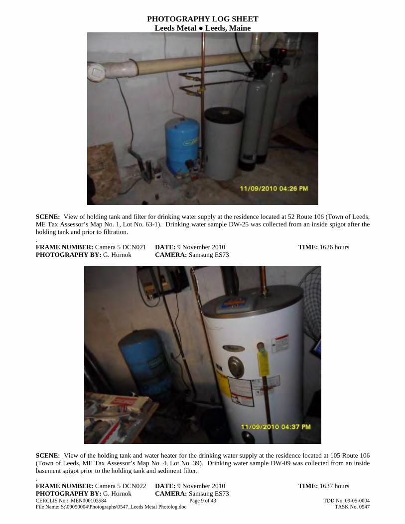
PHOTOGRAPHY LOG SHEET Leeds Metal ● Leeds, Maine
CERCLIS No.: MEN000103584 Page 9 of 43 TDD No. 09-05-0004 File Name: S:\09050004\Photographs\0547_Leeds Metal Photolog.doc TASK No. 0547
SCENE: View of holding tank and filter for drinking water supply at the residence located at 52 Route 106 (Town of Leeds, ME Tax Assessor’s Map No. 1, Lot No. 63-1). Drinking water sample DW-25 was collected from an inside spigot after the holding tank and prior to filtration. . FRAME NUMBER: Camera 5 DCN021 DATE: 9 November 2010 TIME: 1626 hours PHOTOGRAPHY BY: G. Hornok CAMERA: Samsung ES73
SCENE: View of the holding tank and water heater for the drinking water supply at the residence located at 105 Route 106 (Town of Leeds, ME Tax Assessor’s Map No. 4, Lot No. 39). Drinking water sample DW-09 was collected from an inside basement spigot prior to the holding tank and sediment filter. . FRAME NUMBER: Camera 5 DCN022 DATE: 9 November 2010 TIME: 1637 hours PHOTOGRAPHY BY: G. Hornok CAMERA: Samsung ES73

PHOTOGRAPHY LOG SHEET Leeds Metal ● Leeds, Maine
CERCLIS No.: MEN000103584 Page 10 of 43 TDD No. 09-05-0004 File Name: S:\09050004\Photographs\0547_Leeds Metal Photolog.doc TASK No. 0547
SCENE: View of the outside spigot and the drinking water supply well for the residence located at 53 Blue Rock Road (Town of Monmouth, ME Tax Assessor’s Map No. 20, Lot No. 2-1). Drinking water sample DW-08 was collected from the outside spigot after the holding tank and prior to filtration. FRAME NUMBER: Camera 6 DCN043 DATE: 17 November 2010 TIME: 1148 hours PHOTOGRAPHY BY: G. Hornok CAMERA: Samsung ES73
SCENE: View of the outside spigot in the front of the residence located at 73 Route 106 (Town of Leeds, ME Tax Assessor’s Map No. 1, Lot No. 58-4). Drinking water sample DW-19 was collected from the outside spigot after the holding tank. FRAME NUMBER: Camera 6 DCN044 DATE: 17 November 2010 TIME: 1234 hours PHOTOGRAPHY BY: G. Hornok CAMERA: Samsung ES73

PHOTOGRAPHY LOG SHEET Leeds Metal ● Leeds, Maine
CERCLIS No.: MEN000103584 Page 11 of 43 TDD No. 09-05-0004 File Name: S:\09050004\Photographs\0547_Leeds Metal Photolog.doc TASK No. 0547
SCENE: View of the spigot in the rear of the residence located at 53 Route 106 (Town of Leeds, ME Tax Assessor’s Map No. 1, Lot No. 58-1). Drinking water sample DW-31 was collected from the outside spigot after the holding tank. FRAME NUMBER: Camera 6 DCN045 DATE: 17 November 2010 TIME: 1321 hours PHOTOGRAPHY BY: G. Hornok CAMERA: Samsung ES73
SCENE: View of the holding tank for the drinking water supply at the residence located at 4 Young’s Drive (Town of Leeds, ME Tax Assessor’s Map No. 1, Lot No. 67-1). Drinking water sample DW-12 was collected from an inside basement spigot after the holding tank. FRAME NUMBER: Camera 6 DCN046 DATE: 17 November 2010 TIME: 1618 hours PHOTOGRAPHY BY: G. Hornok CAMERA: Samsung ES73

PHOTOGRAPHY LOG SHEET Leeds Metal ● Leeds, Maine
CERCLIS No.: MEN000103584 Page 12 of 43 TDD No. 09-05-0004 File Name: S:\09050004\Photographs\0547_Leeds Metal Photolog.doc TASK No. 0547
SCENE: View of the outside spigot on the residence located at 45 Lowmoore Drive (Town of Leeds, ME Tax Assessor’s Map No. 1, Lot No. 57-5). Drinking water sample DW-26 was collected from the outside spigot after the holding tank. FRAME NUMBER: Camera 6 DCN047 DATE: 17 November 2010 TIME: 1653 hours PHOTOGRAPHY BY: G, Hornok CAMERA: Samsung ES73
SCENE: View of the holding tank and water softener at the residence located at 60 Route 106 (Town of Leeds, ME Tax Assessor’s Map No. 1, Lot No. 63-2). Drinking water sample DW-24 was collected from an outside spigot of the residence after the holding tank and prior to the water softener. FRAME NUMBER: Camera 5 DCN018 DATE: 9 November 2010 TIME: 1200 hours PHOTOGRAPHY BY: G. Hornok CAMERA: Samsung ES73

PHOTOGRAPHY LOG SHEET Leeds Metal ● Leeds, Maine
CERCLIS No.: MEN000103584 Page 13 of 43 TDD No. 09-05-0004 File Name: S:\09050004\Photographs\0547_Leeds Metal Photolog.doc TASK No. 0547
SCENE: View of the access road on the central portion of the Leeds Metal property (Former Operations Area). Photograph taken facing north. FRAME NUMBER: Camera 6 DCN092 DATE: 2 December 2010 TIME: 0937 hours PHOTOGRAPHY BY: G. Hornok CAMERA: Samsung ES73
SCENE: View of the southwestern portion of the Leeds Metal property (Former Operations Area) from the top of Debris Pile D, located in the southern portion of the property. Photograph taken facing west. FRAME NUMBER: Recon DCN005 DATE: 16 March 2010 TIME: 1219 hours PHOTOGRAPHY BY: G. Hornok CAMERA: HP M22

PHOTOGRAPHY LOG SHEET Leeds Metal ● Leeds, Maine
CERCLIS No.: MEN000103584 Page 14 of 43 TDD No. 09-05-0004 File Name: S:\09050004\Photographs\0547_Leeds Metal Photolog.doc TASK No. 0547
SCENE: View of the central portion of the Leeds Metal property (Former Operations Area) from the top of Debris Pile D. Note Debris Pile B in the background of the photograph. Photograph taken facing northeast. FRAME NUMBER: Recon DCN006 DATE: 16 March 2010 TIME: 1219 hours PHOTOGRAPHY BY: G. Hornok CAMERA: HP M22
SCENE: View of the southern portion of the Leeds Metal property from the top of Debris Pile D. Photograph taken facing southeast. FRAME NUMBER: Recon DCN007 DATE: 16 March 2010 TIME: 1220 hours PHOTOGRAPHY BY: G. Hornok CAMERA: HP M22

PHOTOGRAPHY LOG SHEET Leeds Metal ● Leeds, Maine
CERCLIS No.: MEN000103584 Page 15 of 43 TDD No. 09-05-0004 File Name: S:\09050004\Photographs\0547_Leeds Metal Photolog.doc TASK No. 0547
SCENE: View of the central portion of the Leeds Metal property (Former Operations Area) from Debris Pile D. Photograph taken facing north. FRAME NUMBER: Recon DCN008 DATE: 16 March 2010 TIME: 1220 hours PHOTOGRAPHY BY: G. Hornok CAMERA: HP M22
SCENE: View of the south slope of Debris Pile D. Photograph taken facing north. FRAME NUMBER: Recon DCN010 DATE: 16 March 2010 TIME: 1222 hours PHOTOGRAPHY BY: G. Hornok CAMERA: HP M22

PHOTOGRAPHY LOG SHEET Leeds Metal ● Leeds, Maine
CERCLIS No.: MEN000103584 Page 16 of 43 TDD No. 09-05-0004 File Name: S:\09050004\Photographs\0547_Leeds Metal Photolog.doc TASK No. 0547
SCENE: View of Debris Pile C, located on the central portion of the Leeds Metal property. Photograph taken facing northwest. FRAME NUMBER: Recon DCN011 DATE: 16 March 2010 TIME: 1222 hours PHOTOGRAPHY BY: G. Hornok CAMERA: HP M22
SCENE: View of the southwestern slope of Debris Pile B, located on the southeastern portion of the Leeds Metal property. Photograph taken facing east. FRAME NUMBER: Recon DCN012 DATE: 16 March 2010 TIME: 1223 hours PHOTOGRAPHY BY: G. Hornok CAMERA: HP M22

PHOTOGRAPHY LOG SHEET Leeds Metal ● Leeds, Maine
CERCLIS No.: MEN000103584 Page 17 of 43 TDD No. 09-05-0004 File Name: S:\09050004\Photographs\0547_Leeds Metal Photolog.doc TASK No. 0547
SCENE: View of material on the southern slope of Debris Pile B. Photograph taken facing north. FRAME NUMBER: Camera 6 DCN084 DATE: 2 December 2010 TIME: 0914 hours PHOTOGRAPHY BY: G. Hornok CAMERA: Samsung ES73
SCENE: View of crushed and rusted drums adjacent to the southern slope of Debris Pile B. Photograph taken facing east. FRAME NUMBER: Recon DCN014 DATE: 16 March 2010 TIME: 1231 hours PHOTOGRAPHY BY: G. Hornok CAMERA: HP M22

PHOTOGRAPHY LOG SHEET Leeds Metal ● Leeds, Maine
CERCLIS No.: MEN000103584 Page 18 of 43 TDD No. 09-05-0004 File Name: S:\09050004\Photographs\0547_Leeds Metal Photolog.doc TASK No. 0547
SCENE: View of the eastern portion of the Leeds Metal property (Former Operations Area) adjacent to the eastern toe slope of Debris Pile B. Photograph taken facing north. FRAME NUMBER: Camera 6 DCN109 DATE: 2 December 2010 TIME: 1037 hours PHOTOGRAPHY BY: G. Hornok CAMERA: Samsung ES73
SCENE: View of the western slope of Debris Pile A, located on the central portion of the Leeds Metal property. Note the on-site building in the background. Photograph taken facing east. FRAME NUMBER: Recon DCN019 DATE: 16 March 2010 TIME: 1239 hours PHOTOGRAPHY BY: G. Hornok CAMERA: HP M22

PHOTOGRAPHY LOG SHEET Leeds Metal ● Leeds, Maine
CERCLIS No.: MEN000103584 Page 19 of 43 TDD No. 09-05-0004 File Name: S:\09050004\Photographs\0547_Leeds Metal Photolog.doc TASK No. 0547
SCENE: View of Debris Pile A. Photograph taken facing west. FRAME NUMBER: Camera 6 DCN103 DATE: 2 December 2010 TIME: 1015 hours PHOTOGRAPHY BY: G. Hornok CAMERA: Samsung ES73
SCENE: View of the area on the southern portion of the Leeds Metal property (Abandoned Drum Area). Note drums in foreground and background of the photograph. Photograph taken facing west. FRAME NUMBER: Recon DCN017 DATE: 16 March 2010 TIME: 1233 hours PHOTOGRAPHY BY: G. Hornok CAMERA: HP M22
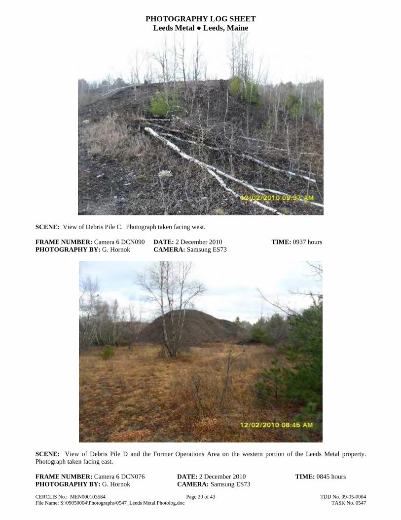
PHOTOGRAPHY LOG SHEET Leeds Metal ● Leeds, Maine
CERCLIS No.: MEN000103584 Page 20 of 43 TDD No. 09-05-0004 File Name: S:\09050004\Photographs\0547_Leeds Metal Photolog.doc TASK No. 0547
SCENE: View of Debris Pile C. Photograph taken facing west. FRAME NUMBER: Camera 6 DCN090 DATE: 2 December 2010 TIME: 0937 hours PHOTOGRAPHY BY: G. Hornok CAMERA: Samsung ES73
SCENE: View of Debris Pile D and the Former Operations Area on the western portion of the Leeds Metal property. Photograph taken facing east. FRAME NUMBER: Camera 6 DCN076 DATE: 2 December 2010 TIME: 0845 hours PHOTOGRAPHY BY: G. Hornok CAMERA: Samsung ES73

PHOTOGRAPHY LOG SHEET Leeds Metal ● Leeds, Maine
CERCLIS No.: MEN000103584 Page 21 of 43 TDD No. 09-05-0004 File Name: S:\09050004\Photographs\0547_Leeds Metal Photolog.doc TASK No. 0547
SCENE: View of the northern slope of Debris Pile D, located in the southern portion of the Leeds Metal property. Area noted for elevated concentrations of tetrachloroethene and trichloroethene. Photograph taken facing west. FRAME NUMBER: Camera 6 DCN078 DATE: 2 December 2010 TIME: 0858 hours PHOTOGRAPHY BY: G. Hornok CAMERA: Samsung ES73
SCENE: View of the Container Disposal Area located in the southwest portion of the Leeds Metal property, adjacent to Route 106. Photograph taken facing southwest. FRAME NUMBER: Camera 6 DCN067 DATE: 2 December 2010 TIME: 0820 hours PHOTOGRAPHY BY: G. Hornok CAMERA: Samsung ES73
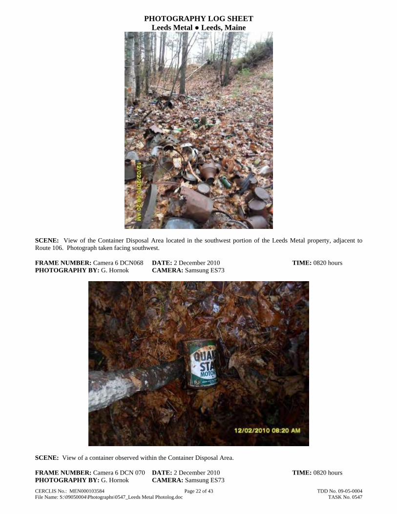
PHOTOGRAPHY LOG SHEET Leeds Metal ● Leeds, Maine
CERCLIS No.: MEN000103584 Page 22 of 43 TDD No. 09-05-0004 File Name: S:\09050004\Photographs\0547_Leeds Metal Photolog.doc TASK No. 0547
SCENE: View of the Container Disposal Area located in the southwest portion of the Leeds Metal property, adjacent to Route 106. Photograph taken facing southwest. FRAME NUMBER: Camera 6 DCN068 DATE: 2 December 2010 TIME: 0820 hours PHOTOGRAPHY BY: G. Hornok CAMERA: Samsung ES73
SCENE: View of a container observed within the Container Disposal Area. FRAME NUMBER: Camera 6 DCN 070 DATE: 2 December 2010 TIME: 0820 hours PHOTOGRAPHY BY: G. Hornok CAMERA: Samsung ES73

PHOTOGRAPHY LOG SHEET Leeds Metal ● Leeds, Maine
CERCLIS No.: MEN000103584 Page 23 of 43 TDD No. 09-05-0004 File Name: S:\09050004\Photographs\0547_Leeds Metal Photolog.doc TASK No. 0547
SCENE: View of containers observed within the Container Disposal Area. FRAME NUMBER: Recon DCN 002 DATE: 16 March 2010 TIME: 1156 hours PHOTOGRAPHY BY: G. Hornok CAMERA: Samsung ES73
SCENE: View of exposed and partially buried drums on the southern portion of the Leeds Metal property (Abandoned Drum Area). Photograph taken facing west. FRAME NUMBER: Camera 6 DCN087 DATE: 2 December 2010 TIME: 0926 hours PHOTOGRAPHY BY: G. Hornok CAMERA: Samsung ES73

PHOTOGRAPHY LOG SHEET Leeds Metal ● Leeds, Maine
CERCLIS No.: MEN000103584 Page 24 of 43 TDD No. 09-05-0004 File Name: S:\09050004\Photographs\0547_Leeds Metal Photolog.doc TASK No. 0547
SCENE: View of exposed and partially buried drums on the southern portion of the Leeds Metal property (Abandoned Drum Area). Photograph taken facing north. FRAME NUMBER: Camera 6 DCN088 DATE: 2 December 2010 TIME: 0927 hours PHOTOGRAPHY BY: G. Hornok CAMERA: Samsung ES73
SCENE: View of drums and debris in a depression on the central portion of the Leeds Metal property (Former Operations Area), adjacent to the access road. Photograph taken facing south. FRAME NUMBER: Camera 6 DCN094 DATE: 2 December 2010 TIME: 0942 hours PHOTOGRAPHY BY: G. Hornok CAMERA: Samsung ES73

PHOTOGRAPHY LOG SHEET Leeds Metal ● Leeds, Maine
CERCLIS No.: MEN000103584 Page 25 of 43 TDD No. 09-05-0004 File Name: S:\09050004\Photographs\0547_Leeds Metal Photolog.doc TASK No. 0547
SCENE: View of the railroad bridge abutments on the northeastern portion of the Leeds Metal property. Photograph taken facing northwest. FRAME NUMBER: Camera 6 DCN095 DATE: 2 December 2010 TIME: 0946 hours PHOTOGRAPHY BY: G. Hornok CAMERA: Samsung ES73
SCENE: View of the truck scale located on the northeastern portion of the Leeds Metal property, adjacent to the Battery Drop Area. Photograph taken facing southeast. FRAME NUMBER: Camera 6 DCN098 DATE: 2 December 2010 TIME: 1002 hours PHOTOGRAPHY BY: G. Hornok CAMERA: Samsung ES73
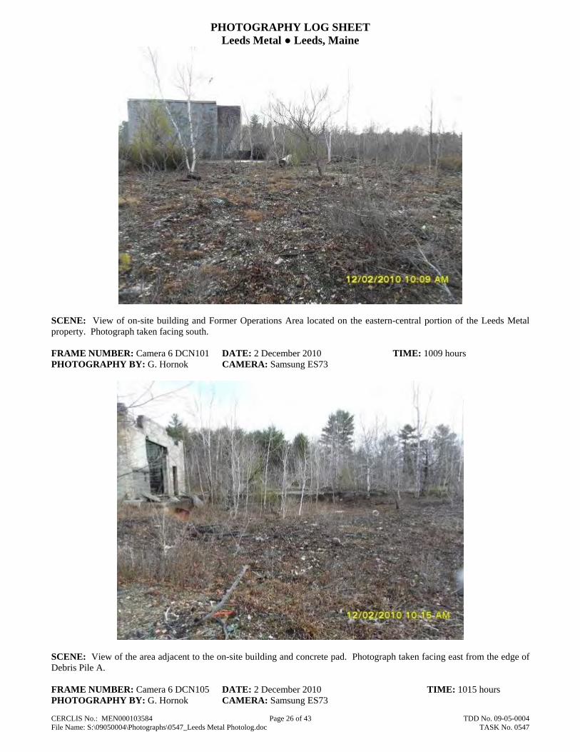
PHOTOGRAPHY LOG SHEET Leeds Metal ● Leeds, Maine
CERCLIS No.: MEN000103584 Page 26 of 43 TDD No. 09-05-0004 File Name: S:\09050004\Photographs\0547_Leeds Metal Photolog.doc TASK No. 0547
SCENE: View of on-site building and Former Operations Area located on the eastern-central portion of the Leeds Metal property. Photograph taken facing south. FRAME NUMBER: Camera 6 DCN101 DATE: 2 December 2010 TIME: 1009 hours PHOTOGRAPHY BY: G. Hornok CAMERA: Samsung ES73
SCENE: View of the area adjacent to the on-site building and concrete pad. Photograph taken facing east from the edge of Debris Pile A. FRAME NUMBER: Camera 6 DCN105 DATE: 2 December 2010 TIME: 1015 hours PHOTOGRAPHY BY: G. Hornok CAMERA: Samsung ES73

PHOTOGRAPHY LOG SHEET Leeds Metal ● Leeds, Maine
CERCLIS No.: MEN000103584 Page 27 of 43 TDD No. 09-05-0004 File Name: S:\09050004\Photographs\0547_Leeds Metal Photolog.doc TASK No. 0547
SCENE: View of the on-site building and concrete pad. Photograph taken facing north. FRAME NUMBER: Camera 6 DCN107 DATE: 2 December 2010 TIME: 1018 hours PHOTOGRAPHY BY: G. Hornok CAMERA: Samsung ES73
SCENE: View of groundwater monitoring well RX-3S located on the northern portion of the Leeds Metal property. Groundwater sample GW-11 was collected from this well. Photograph taken facing east. FRAME NUMBER: Camera 5 DCN016 DATE: 9 November 2010 TIME: 1046 hours PHOTOGRAPHY BY: G. Hornok CAMERA: Samsung ES73

PHOTOGRAPHY LOG SHEET Leeds Metal ● Leeds, Maine
CERCLIS No.: MEN000103584 Page 28 of 43 TDD No. 09-05-0004 File Name: S:\09050004\Photographs\0547_Leeds Metal Photolog.doc TASK No. 0547
SCENE: View of groundwater monitoring well RX-2S located on the northern portion of the Leeds Metal property. Groundwater sample GW-12 was collected from this well. Note former concrete manufacturing plant in the background. Photograph taken facing north. FRAME NUMBER: Camera 6 DCN063 DATE: 2 December 2010 TIME: 0803 hours PHOTOGRAPHY BY: G. Hornok CAMERA: Samsung ES73
SCENE: View of groundwater monitoring wells ERM-3S and ERM-3D located on the southern property boundary of the Leeds Metal property. Groundwater samples GW-08 and GW-09 were collected from these monitoring wells. Photograph taken facing south. FRAME NUMBER: Camera 6 DCN077 DATE: 12 December 2010 TIME: 0845 hours PHOTOGRAPHY BY: G. Hornok CAMERA: Samsung ES73

PHOTOGRAPHY LOG SHEET Leeds Metal ● Leeds, Maine
CERCLIS No.: MEN000103584 Page 29 of 43 TDD No. 09-05-0004 File Name: S:\09050004\Photographs\0547_Leeds Metal Photolog.doc TASK No. 0547
SCENE: View of groundwater monitoring well ERM-5S located on the central portion of the Leeds Metal property. Ground water sample GW-01 was collected from this monitoring well. Photograph taken facing south. FRAME NUMBER: Camera 6 DCN093 DATE: 12 December 2010 TIME: 0941 hours PHOTOGRAPHY BY: G. Hornok CAMERA: Samsung ES73
SCENE: View of the on-site wetlands and Concrete Disposal Area located along the northern property boundary of the Leeds Metal property. Photograph taken facing east. FRAME NUMBER: Camera 6 DCN054 DATE: 29 November 2010 TIME: 1501 hours PHOTOGRAPHY BY: G. Hornok CAMERA: Samsung ES73

PHOTOGRAPHY LOG SHEET Leeds Metal ● Leeds, Maine
CERCLIS No.: MEN000103584 Page 30 of 43 TDD No. 09-05-0004 File Name: S:\09050004\Photographs\0547_Leeds Metal Photolog.doc TASK No. 0547
SCENE: View of the wetlands located along the northern property boundary of the Leeds Metal property. Photograph taken facing southwest from the top of the Concrete Disposal Area. FRAME NUMBER: Camera 6 DCN055 DATE: 29 November 2010 TIME: 1501 hours PHOTOGRAPHY BY: G. Hornok CAMERA: Samsung ES73
SCENE: View of the on-site wetlands and Concrete Disposal Area, located along the northern property boundary of the Leeds Metal property. Photograph taken facing west. FRAME NUMBER: Camera 5 DCN014 DATE: 9 November 2010 TIME: 1046 hours PHOTOGRAPHY BY: G. Hornok CAMERA: Samsung ES73

PHOTOGRAPHY LOG SHEET Leeds Metal ● Leeds, Maine
CERCLIS No.: MEN000103584 Page 31 of 43 TDD No. 09-05-0004 File Name: S:\09050004\Photographs\0547_Leeds Metal Photolog.doc TASK No. 0547
SCENE: View of the production well located within the Concrete Disposal Area, located along the northern property boundary of the Leeds Metal property. Photograph taken facing east and looking down on the well. FRAME NUMBER: Camera 6 DCN058 DATE: 29 November 2010 TIME: 1505 hours PHOTOGRAPHY BY: G. Hornok CAMERA: Samsung ES73
SCENE: View of the southern lagoon located in the northwestern portion of the Leeds Metal property. Photograph taken facing northeast. FRAME NUMBER: Camera 6 DCN064 DATE: 2 December 2010 TIME: 0817 hours PHOTOGRAPHY BY: G. Hornok CAMERA: Samsung ES73

PHOTOGRAPHY LOG SHEET Leeds Metal ● Leeds, Maine
CERCLIS No.: MEN000103584 Page 32 of 43 TDD No. 09-05-0004 File Name: S:\09050004\Photographs\0547_Leeds Metal Photolog.doc TASK No. 0547
SCENE: View of the northern lagoon, located in the northwestern portion of the Leeds Metal property. Photograph taken facing northeast. Note the drum in the foreground of the photograph. FRAME NUMBER: Camera 6 DCN 065 DATE: 2 December 2010 TIME: 0819 hours PHOTOGRAPHY BY: G. Hornok CAMERA: Samsung ES73
SCENE: View of Bonney Pond near the confluence of the Unnamed Stream, located northeast of the Leeds Metal property. Location of sediment sample SD-18. Photograph taken facing south. FRAME NUMBER: Camera 5 DCN026 DATE: 15 November 2010 TIME: 1128 hours PHOTOGRAPHY BY: G. Hornok CAMERA: Samsung ES73

PHOTOGRAPHY LOG SHEET Leeds Metal ● Leeds, Maine
CERCLIS No.: MEN000103584 Page 33 of 43 TDD No. 09-05-0004 File Name: S:\09050004\Photographs\0547_Leeds Metal Photolog.doc TASK No. 0547
SCENE: View of Bonney Pond, located northeast of the Leeds Metal property. Photograph taken facing northeast. FRAME NUMBER: Camera 5 DCN028 DATE: 10 November 2010 TIME: 1128 hours PHOTOGRAPHY BY: G. Hornok CAMERA: Samsung ES73
SCENE: View of the location of sediment sample SD-17, along the Unnamed Stream located northeast of the Leeds Metal property. Photograph taken facing south. FRAME NUMBER: Camera 5 DCN029 DATE: 15 November 2010 TIME: 1200 hours PHOTOGRAPHY BY: G. Hornok CAMERA: Samsung ES73

PHOTOGRAPHY LOG SHEET Leeds Metal ● Leeds, Maine
CERCLIS No.: MEN000103584 Page 34 of 43 TDD No. 09-05-0004 File Name: S:\09050004\Photographs\0547_Leeds Metal Photolog.doc TASK No. 0547
SCENE: View of the Unnamed Stream located northeast of the Leeds Metal property. Photograph taken facing southwest. FRAME NUMBER: Camera 5 DCN030 DATE: 15 November 2010 TIME: 1200 hours PHOTOGRAPHY BY: G. Hornok CAMERA: Samsung ES73
SCENE: View of the Unnamed Stream and culvert that directs surface water beneath Blue Rock Road, located east of the Leeds Metal property. Note the location of sediment sample SD-16 in the foreground (marked by a pin flag). Photograph taken facing southwest. FRAME NUMBER: Camera 5 DCN033 DATE: 15 November 2008 TIME: 1224 hours PHOTOGRAPHY BY: G. Hornok CAMERA: Samsung ES73

PHOTOGRAPHY LOG SHEET Leeds Metal ● Leeds, Maine
CERCLIS No.: MEN000103584 Page 35 of 43 TDD No. 09-05-0004 File Name: S:\09050004\Photographs\0547_Leeds Metal Photolog.doc TASK No. 0547
SCENE: View of the ponded portion of the Unnamed Stream located east of the Leeds Metal property. Photograph taken facing southwest. FRAME NUMBER: Camera 5 DCN034 DATE: 15 November 2010 TIME: 1224 hours PHOTOGRAPHY BY: G. Hornok CAMERA: Samsung ES73
SCENE: View of the location of sediment sample SD-15, along the Unnamed Stream located east of the Leeds Metal property. Photograph taken facing south. FRAME NUMBER: Camera 5 DCN035 DATE: 15 November 2010 TIME: 1313 hours PHOTOGRAPHY BY: G. Hornok CAMERA: Samsung ES73

PHOTOGRAPHY LOG SHEET Leeds Metal ● Leeds, Maine
CERCLIS No.: MEN000103584 Page 36 of 43 TDD No. 09-05-0004 File Name: S:\09050004\Photographs\0547_Leeds Metal Photolog.doc TASK No. 0547
SCENE: View of the Unnamed Stream immediately upstream of sediment sample location SD-15, located east of the Leeds Metal property. Note the orange flagging designating the location of beaver traps. Photograph taken facing south. FRAME NUMBER: Camera 5 DCN037 DATE: 15 November 2010 TIME: 1317 hours PHOTOGRAPHY BY: G. Hornok CAMERA: Samsung ES73
SCENE: View of the location of sediment sample SD-14, along a groundwater-to-surface water seep where the Unnamed Stream emerges east of the railroad bed, southeast of the Leeds Metal property. Photograph taken facing south. FRAME NUMBER: Camera 5 DCN041 DATE: 15 November 2010 TIME: 1351 hours PHOTOGRAPHY BY: G. Hornok CAMERA: Samsung ES73

PHOTOGRAPHY LOG SHEET Leeds Metal ● Leeds, Maine
CERCLIS No.: MEN000103584 Page 37 of 43 TDD No. 09-05-0004 File Name: S:\09050004\Photographs\0547_Leeds Metal Photolog.doc TASK No. 0547
SCENE: View of the Unnamed Stream east of the railroad bed and downstream of sediment sample location SD-14, southeast of the Leeds Metal property. Photograph taken facing northeast. FRAME NUMBER: Camera 5 DCN042 DATE: 15 November 2010 TIME: 1351 hours PHOTOGRAPHY BY: G. Hornok CAMERA: Samsung ES73
SCENE: View of the location of sediment sample SD-13, within a wetland area located directly south of the Leeds Metal property and west of the railroad tracks. Photograph taken facing southwest. FRAME NUMBER: Camera 6 DCN027 DATE: 15 November 2010 TIME: 1508 hours PHOTOGRAPHY BY: D. Brammer CAMERA: Samsung ES73

PHOTOGRAPHY LOG SHEET Leeds Metal ● Leeds, Maine
CERCLIS No.: MEN000103584 Page 38 of 43 TDD No. 09-05-0004 File Name: S:\09050004\Photographs\0547_Leeds Metal Photolog.doc TASK No. 0547
SCENE: View of the location of sediment sample SD-34, along the Unnamed Intermittent Stream located south of the Leeds Metal property. Photograph taken facing southwest. FRAME NUMBER: Camera 6 DCN023 DATE: 15 November 2010 TIME: 1205 hours PHOTOGRAPHY BY: J. Kelly CAMERA: Samsung ES73
SCENE: View of the location of sediment sample SD-34, adjacent to a partially buried drum and the Unnamed Intermittent Stream, south of the Leeds Metal property. Photograph taken facing east. FRAME NUMBER: Camera 6 DCN024 DATE: 15 November 2010 TIME: 1207 hours PHOTOGRAPHY BY: J. Kelly CAMERA: Samsung ES73

PHOTOGRAPHY LOG SHEET Leeds Metal ● Leeds, Maine
CERCLIS No.: MEN000103584 Page 39 of 43 TDD No. 09-05-0004 File Name: S:\09050004\Photographs\0547_Leeds Metal Photolog.doc TASK No. 0547
SCENE: View of the location of sediment sample SD-04, within a wetland along Blue Rock Road, east of the Leeds Metal property. Photograph taken facing northeast. FRAME NUMBER: Camera 6 DCN034 DATE: 16 November 2010 TIME: 1221 hours PHOTOGRAPHY BY: J. Kelly CAMERA: Samsung ES73
SCENE: View of the location of sediment sample SD-23, within a groundwater seep along an intermittent stream discharging into the Dead River No. 2, southwest of the Leeds Metal property. Photograph taken facing north. FRAME NUMBER: Camera 5 DCN045 DATE: 19 November 2010 TIME: 1100 hours PHOTOGRAPHY BY: G. Hornok CAMERA: Samsung ES73

PHOTOGRAPHY LOG SHEET Leeds Metal ● Leeds, Maine
CERCLIS No.: MEN000103584 Page 40 of 43 TDD No. 09-05-0004 File Name: S:\09050004\Photographs\0547_Leeds Metal Photolog.doc TASK No. 0547
SCENE: View of a tributary of the Dead River No. 2 located southwest of the Leeds Metal Property. The tributary begins as a groundwater seep. Photograph taken facing northeast. . FRAME NUMBER: Camera 5 DCN046 DATE: 19 November 2010 TIME: 1100 hours PHOTOGRAPHY BY: G. Hornok CAMERA: Samsung ES73
SCENE: View of a tributary of the Dead River No. 2 located southwest of the Leeds Metal Property. The tributary begins as a groundwater seep. Photograph taken facing north. FRAME NUMBER: Camera 5 DCN047 DATE: 19 November 2010 TIME: 1110 hours PHOTOGRAPHY BY: G. Hornok CAMERA: Samsung ES73

PHOTOGRAPHY LOG SHEET Leeds Metal ● Leeds, Maine
CERCLIS No.: MEN000103584 Page 41 of 43 TDD No. 09-05-0004 File Name: S:\09050004\Photographs\0547_Leeds Metal Photolog.doc TASK No. 0547
SCENE: View of the location of sediment sample SD-27, near a snowmobile bridge along Dead River No. 2. Photograph taken facing northeast. FRAME NUMBER: Sept. recon DCN005 DATE: 2 September 2010 TIME: 1322 hours PHOTOGRAPHY BY: G. Hornok CAMERA: Samsung ES73
SCENE: View of the Dead River No. 2 from a snowmobile bridge located southwest of the Leeds Metal Property. Photograph taken facing south. FRAME NUMBER: Sept. recon DCN006 DATE: 2 September 2010 TIME: 1322 hours PHOTOGRAPHY BY: G. Hornok CAMERA: Samsung ES73

PHOTOGRAPHY LOG SHEET Leeds Metal ● Leeds, Maine
CERCLIS No.: MEN000103584 Page 42 of 43 TDD No. 09-05-0004 File Name: S:\09050004\Photographs\0547_Leeds Metal Photolog.doc TASK No. 0547
SCENE: View of the location of sediment sample SD-08, within the northern lagoon located on the northwest portion of the Leeds Metal Property. Photograph taken facing southeast. . FRAME NUMBER: Camera 6 DCN013 DATE: 09 November 2010 TIME: 1217 hours PHOTOGRAPHY BY: J. Kelly CAMERA: Samsung ES73
SCENE: View of the location of sediment sample SD-05, within the on-site wetland located on the northwestern portion of the Leeds Metal property. Photograph taken facing west. . FRAME NUMBER: Camera 6 DCN014 DATE: 9 November 2010 TIME: 1255 hours PHOTOGRAPHY BY: J. Kelly CAMERA: Samsung ES73

PHOTOGRAPHY LOG SHEET Leeds Metal ● Leeds, Maine
CERCLIS No.: MEN000103584 Page 43 of 43 TDD No. 09-05-0004 File Name: S:\09050004\Photographs\0547_Leeds Metal Photolog.doc TASK No. 0547
SCENE: View of the locations of sediment samples SD-10 and field duplicate SD-32, along the on-site pond in the central portion of the Leeds Metal Property. Photograph taken facing west. FRAME NUMBER: Camera 6 DCN015 DATE: 9 November 2010 TIME: 1350 hours PHOTOGRAPHY BY: J. Kelly CAMERA: Samsung ES73
SCENE: View of the on-site pond located in the central portion of the Leeds Metal Property. Photograph taken facing northeast. . FRAME NUMBER: Camera 6 DCN089 DATE: 2 December 2010 TIME: 0936 hours PHOTOGRAPHY BY: G. Hornok CAMERA: Samsung ES73