ycccart 2011 /y 20 north somerset her 2012/141 report … cadbury hill y20 final... · report on...
TRANSCRIPT

YCCCART 2011 /Y 20 North Somerset HER 2012/141
Report on geophysical surveys at Cadbury Hill, Congresbury
YATTON, CONGRESBURY, CLAVERHAM AND CLEEVE ARCHAEOLOGICAL RESEARCH TEAM
(YCCCART)
General Editor: Vince Russett
Richard operating the RM 15, Colin on the wire and behind them members of the manual survey team.
Page 1

Page 2
Page 3 4 5 8 9 31 32
Contents
Abstract Acknowledgements Introduction Site location Land use and geology Historical & archaeological context Survey Objectives Methodology Results Recommendations References Appendix A – Site Record

Abstract YCCCART has agreed with the Heritage Lottery Fund to undertake a project over two years commencing May 2009 to establish the extent of the Congresbury Roman kiln sites and investigate the archaeology of the environs on and around Cadbury Hill, Congresbury. Gradiometry and resistivity surveys show a number of features previously identified in excavation and earthwork survey, and many other previously unknown features. Acknowledgements A Heritage Lottery Grant enabled the purchase, by YCCCART, of a Geoscan RM 15 Resistance Meter and a Bartington Gradiometer 601, without which this survey could not have been undertaken. YCCCART is most grateful to Golden Software for their providing a free copy of Surfer software. This survey would also not have been carried out without the willing permission of Yatton and Congresbury Parish Councils and English Heritage. The authors are grateful for the British Library for permission to reproduce the sketch by the Rev Skinner, Mark Corney for allowing us to reproduce his Cadbury Hill plan, the hard work by the members of YCCCART in performing the surveys and Vince Russett for editing this report. The survey of this Scheduled Monument was carried out inder English Heritage licence, case number SL00013997 Introduction Yatton, Congresbury, Claverham and Cleeve Archaeological Research Team (YCCCART) is one of a number of Community Archaeology teams across North Somerset, supported by the North Somerset Council Development Management Team. The objective of the Community Archaeology in North Somerset (CANS) teams is to carry out archaeological fieldwork, for the purpose of recording and better understanding and management of the heritage of North Somerset.
Page 3

Site Location
Fig 1: Site location
Cadbury Hill is part of the Cadbury Hill Local Nature Reserve, sited on the parish boundary between Yatton and Congresbury parishes, in North Somerset, the centre of the site being at ST441650. The site is the westernmost point of Broadfield Down, the largely limestone down which occupies much of the central area of North Somerset.
The site can be accessed from the north by Henley Lane, off Frost Hill in Yatton parish, which leads to a small public car park: there is also access by Blind Lane, off the A370 at Rhodyate Hill in Congresbury parish. Land use and geology Cadbury Hill is a public area owned by Congresbury and Yatton Parish Councils and North Somerset Council, and enjoyed by walkers (particularly dog walkers). The hill fort is situated on a small outcrop of Oxwich Head limestone which overlies the Clifton Down limestone formation. The junction of these two formations appears to result in a steeper slope in some places, and at Cadbury Hill this steep slope has been utilised as part of the outer defences.
Page 4

Historical & archaeological context Skinner 1829 The Rev John Skinner, Rector of Camerton in east Somerset (now B&NES), was an antiquarian, working in the first half of the 19th century. During the period 1800-1840, he drew antiquities all over England, Wales and parts of France, and his drawings are the earliest record of some sites that exist.
Skinner identified a bank running across the centre of the hill fort (shown clearly in Fig 2 below) which was not relocated by any field worker until Gardner relocated it in 1959. It is noticeable that Skinner saw a monument completely devoid of trees.
Fortunately, Skinner did not dig at Cadbury, so it was spared the destructive attention he paid to many Mendip barrows.
Fig 2: Rev J Skinners 1829 bird‟s eye view drawing of Cadbury from the south west. (c) British Library Board. BM/Mss 233692
Gardner 1959 Mr K Gardner, local archaeologist and one time chair of Council for British Archaeology (South West), excavated a few well-placed small trenches over some of the features of Cadbury hill-fort in 1959 (Report 2010/Y18; http://www.ycccart.co.uk). These demonstrated that there was extremely well-preserved archaeology at the site, and showed for the first time that the Mediterranean amphorae, of a type then only recently recognised as from the post-Roman Mediterranean world, were present at the site. It was as a result of this work that larger, open plan excavations, were undertaken 10 years later (Fowler, Gardner and Rahtz 1968).
Page 5

Fig 3:1959 excavation on the site of the eastern entrance (Late Keith Gardner collection)
Rahtz et al 1968-1973 Large scale open plan excavations took place at Cadbury in the late 60s and early 70s, to the north of the plantation. This revealed several unexpected facets of the archaeology of the hill, not least, the recognition of post-Roman roundhouses, and connections to the rest of Europe in the fifth and sixth centuries, which until this point had been thought of as a „Dark Age‟ in British affairs. The report (Rahtz et al 1992) summarised its findings: The hill-top of Cadbury Congresbury was frequented in Neolithic and Bronze Age times. Substantial defences were built in the pre-Roman Iron Age, when the site became a multivallate hillfort. This was re-occupied in the latest Roman period (late fifth century AD); new earthworks were subsequently built, including a bank dividing the hillfort into two parts, with a linking entrance way. In the sixth century the group who had initiated these works (or a group supplanting them) had clearly achieved high status, patronising craft-workers, and having access to glass and ceramics from the Anglo-Saxon areas to the east, and from the Eastern Mediterranean, North Africa and possibly France or Spain. In the late sixth or early seventh century the settlement declined and was abandoned, probably due to the major changes initiated by Anglo-Saxon military, political and ecclesiastical domination. Subsequently, some use was made of the hill in the medieval and post-medieval periods. Eight structures of late or post-Roman date were defined, of both rectilinear and sub-circular plan, and a wide variety of other features, including cairns, pits, post-holes, timber-slots, and other emplacements.
Page 6

Finds include flint and other stone, fired and baked clay, ore and slag, iron objects, copper alloy, gold, lead, glass, enamel, coins, bone, pottery (including imports of Phocean Red Slip Ware, African Red Slip Ware, B Ware amphorae, and other ceramics), human and animal remains, mollusca, and botanical residues.
Interpretation of the site can be only tentative on the basis of the small sample excavated (five per cent). The late/post-Roman earthworks may be seen as defensive, but may be merely enclosing banks, possibly defining status, or even delimiting ritual areas. Some evidence suggests that one or more structures and other features had a religious function; there are indications of cult practice involving one or more human skulls of Iron Age date, and a hint of the replacement of this by a feature which has Christian analogues. Discussion ranges over the cultural, political, and religious affiliations of the community; and on its role (or that of its ruling elite) in permanent or periodic activities in relation to a defined territory around the hill. There is also speculation on the available resources, communications, and contacts with the wider British and European world. Corney 2004 Mark Corney, an independent archaeologist, formerly a surveyor for the Royal Commission on Historic Monuments in England (now English Heritage) was commissioned to carry out a detailed earthwork survey of Cadbury hill fort in winter 2003-4 (Cadbury Hill Fort. An Analytical survey by Mark Corney, with Nik Morris. YCCCART 2011/Y3: http://www.ycccart.co.uk ; North Somerset HER2011/041) This survey, carried out in near-perfect conditions, revealed a previously unrecognised wealth of earthworks of prehistoric and later features on the hill top. Unfortunately, Corney‟s commission did not extend to the survey of the presumably Iron Age earthworks on the hill slopes around the hill top. This work has been completed on the whole accessible area of the hill fort by YCCCART (some is still under impenetrable undergrowth). Tabor 2003 Richard Tabor was commissioned by English Heritage to carry out a magnetometry survey of the hilltop at Cadbury Hill. Unfortunately, the material appears to have never been published or even fully processed.
Page 7

Survey objectives The survey had the following objectives. To identify any archaeological features. To use the survey to further train YCCCART members and members of Community
Archaeology in North Somerset (CANS) in the use of the RM 15 Resistance Meter and Bartington 601 gradiometer.
Methodology
The surveys were undertaken during the period February to May 2011 and October 2011 to March 2012 by teams from YCCCART using a Geoscan RM 15 Resistance Meter and Bartington 601 Gradiometer, with settings as per the site records in Appendix A. The completed survey was downloaded to the ArcheoSurveyor, Snuffler and Surfer programmes. ArcheoSurveyor composites were adjusted using the following filters: Grad shade Despiked Destriped (Gradiometer results only) Clip SD2 Black, Green, White Red Green Blue 2 In addition as indicated in the results below a selection of results were further filtered using: Edge Match Range Match High Level Pass The report was written in Microsoft Word 2007. Site photographs were taken by members of YCCCART, and remain the copyright of YCCCART.
Page 8

Results Gradiometry Survey
Fig 4: Grid layout
Fig xx: ArchaeoSurveyor grids
Fig 5: ArchaeoSurveyor grids
Page 9
Fig Man 2: Northern ramparts of Cadbury-Congresbury hillfort, with position of features listed above (1 -12) shown in red.
N

West East
Page 10
Fig 6: Cadbury 601 surveys east and west overlaid on Mark Corney‟s survey Cadbury Hill Fort an Analytical survey by Mark Corney with Nik Morris. North Somerset HER2011/041. YCCCART report 2011/Y6

Eastern Survey
Fig 7: Cadbury East. Left - Gradiometry results overlaid on Mark Corney‟s survey. Right - Mark Coney‟s survey.
Page 11
63 – “Area of
intercutting linear quarries.”
Post Roman
guard houses

Fig 8: Cadbury East. Left - Gradiometry overlaid on YCCCART manual survey. Right – YCCCART manual survey.
Page 12

Fig 9: Shade view. ArcheoSurveyor image. (High readings are black)
There are bands of iron ore on the site (it was mined at least as early as the Iron Age), and it is not known how much this has affected the results. The results shown in Fig 9 above reveal a wealth of features, including previously unrecorded circular structures Also previously unrecorded are what appears to be an internal bank crossing west to east and several parallel lines in the north west. The latter may possibly be track ways or could relate to Mark Corney‟s feature 63 (“Area of intercutting linear quarries” – see Fig 7 above). The post Roman guard houses and internal bank shown in the manual survey (See YCCCART report Y 2012/2 and Fig 8 above) are also evident.
Page 13
Internal bank
Circular feature
on/close to internal bank
Post Roman guard houses
Large
circular
feature
Large
circular
features
Trackways?
Circular
features Bank

Fig 10: Shade view colour ArcheoSurveyor image. (High readings are red)
The high readings in Fig 10 above are most evident along the lines of the banks and area containing the guard houses.
Page 14
Internal bank
Post Roman guard house
Bank

Western Survey
Fig 11: Cadbury West. Left - Gradiometry overlaid on YCCCART manual survey. Right – Mark Coney‟s survey.
Page 15

Fig 12: Shade view. ArcheoSurveyor image. (High readings are black)
A series of what appear to be internal banks are evident as per Fig 11 above, including a bank in the central of the picture running from north to south. The four circular structures identified in Mark Corney‟s survey (See YCCCART report 2011 Y6 page 10 items 18-21) are also identifiable.
In addition there a number of circular features as per the selection indicated by arrows in Fig 12 above.
Page 16
Relates to Mark Corney survey “18-21 Structure complex comprising 4 circular structures
displaying complex earthwork stratigraphy.”
Circular features
Circular features
Enclosure / bank

Fig 13: Shade view. ArcheoSurveyor image with edge match filter. (High readings are black)
The enhanced result per Fig 12 above shows even more circular features particularly to the east of the possible bank.
Page 17
Bank
Large circular feature
Bank
Bank
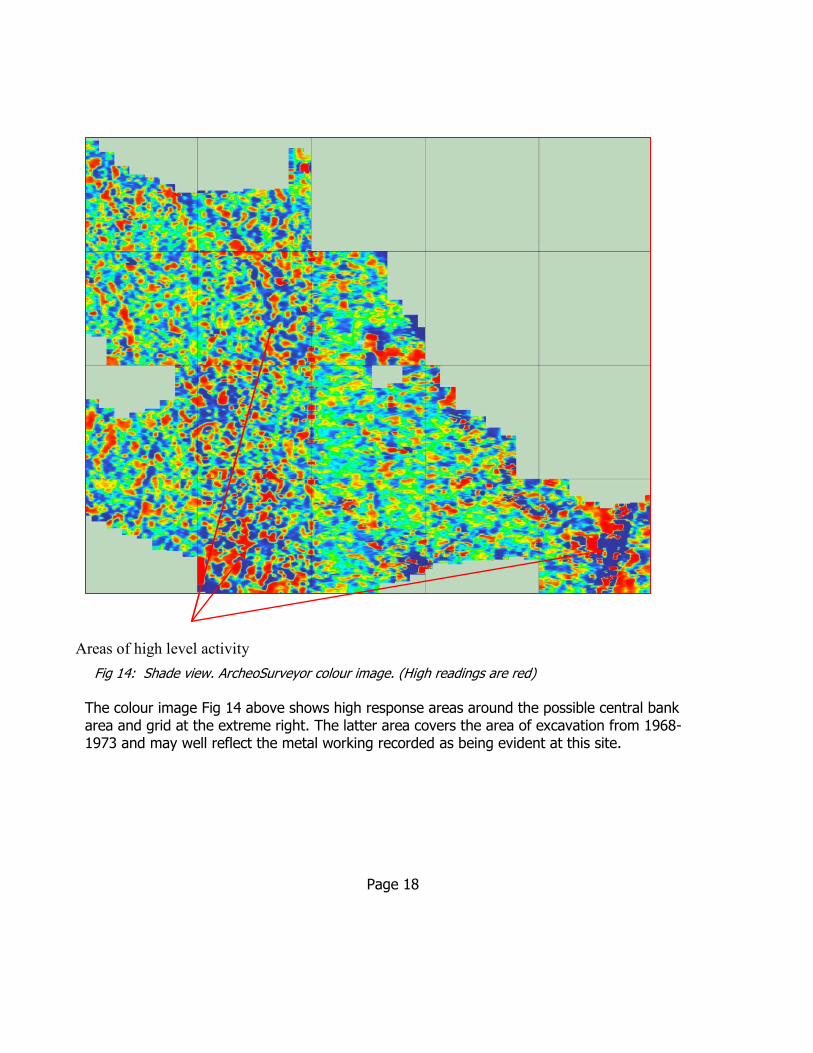
Fig 14: Shade view. ArcheoSurveyor colour image. (High readings are red)
The colour image Fig 14 above shows high response areas around the possible central bank area and grid at the extreme right. The latter area covers the area of excavation from 1968-1973 and may well reflect the metal working recorded as being evident at this site.
Page 18
Areas of high level activity
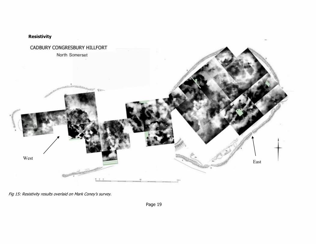
Resistivity
Fig 15: Resistivity results overlaid on Mark Coney‟s survey.
Page 19
West East

Resistivity survey- West
2011
2012
Fig 16: Grid layout and daily readings.
Page 20
1 March 8 March 15 March

Fig 17: ArcheoSurveyor grids
Fig 18: Part of the main survey drawing from Cadbury Hill Fort an Analytical survey by Mark Corney with Nik Morris. YCCCART 2011/Y6, North Somerset HER2011/041.
The above survey was completed during 2004. Fig 18 above shows only the western section of the survey which corresponds to the resistivity survey undertaken by YCCCART. Highlighted in red are two features referred to in the results which follow.
Page 21
18-21. Structure complex comprising 4 circular structures displaying complex earthwork
stratigraphy.
62. Shallow,
irregular quarry pit
within walled enclosure

Fig 19: Shade view. ArcheoSurveyor image. (High readings are black)
Tradionally, resistivity surcey is unreliable on carboniferous limestone geologies, but here, it has been very successful and large number of features have been revealed. The most recognisable is the circular feature towards the top right, which mirrors the plan of Structure II (See top right Fig 19 above) described in the report on the Cadbury Hill excavations during 1968 to 1973 as a shrine or temple (Rahtz, PA, Fowler, P et al 1992. p197). Just below the shrine appears to be part of a structure described in the same report as Structure III. (YCCCART hope to obtain permission to reproduce plans from this report at a later date.) The circular structures middle left appear to relate to the structures described in Mark Corney‟s survey (See YCCCART report 2011 /Y6) as '18-21. Structure complex comprising 4 circular structures displaying complex earthwork stratigraphy‟, which are also evident on the gradiometry results. At bottom right, within the remains of a stone circular walled enclosure believed to have been constructed in Victorian times, is the feature described within Mark Corney‟s survey as “62. Shallow, irregular quarry pit within walled enclosure”. This feature could be that shown but the survey results also shows a potential new structure abutting the south of the potential quarry. Other features include a low resistance line across the middle grids to the left and also top left a large circular feature which seems similar to that at bottom right.
Page 22
Possible quarry pit within
walled enclosure but area
below could be a structure
Structure (possibly structure III)
Shrine or temple
3 circular structures
Circular
feature with internal
structure
Trackway?
Edge of Victorian stone circle
Line of internal
bank?
Round house
Circular feature
and trackway N

Fig 20: Shade view. ArcheoSurveyor Black, Green, White image. High readings are black and low white. Below this is a photograph of Shrine 2 (Courtesy of the late Keith Gardner) The results at Fig 20 above and Fig 21 below further show the range and complexity of anomalies revealed.
Page 23

Fig 21: Shade view. ArcheoSurveyor with enhanced images as indicated
Page 24
Black green white ArcheoSurveyor 3d image with high level filter. Image rotated. 2 grids dated 24 March 2011
ArcheoSurveyor colour 3d image with high level filter. Image rotated. 2 grids dated 15 March
ArcheoSurveyor colour and white green & black 3d images with high level filter. Images rotated. 4 grids dated 11 & 14th March 2011
3D ArcheoSurveyor colour 3d image with high level filter. Image rotated. 2 grids 1 March grid 1 & 8 March grid 1

Resistivity East
1 Dec 8Dec 5Jan 12 Jan 26 Jan 31 Jan
20 Oct 3 Nov
10 Nov 17 Nov
24 Nov
2 Feb 9 Feb 16 Feb 21 Feb 23 Feb Fig 22: Grid layout and daily readings
Page 25

Page 26
Fig 23: ArcheoSurveyor grids and section of Mark Corney‟s survey
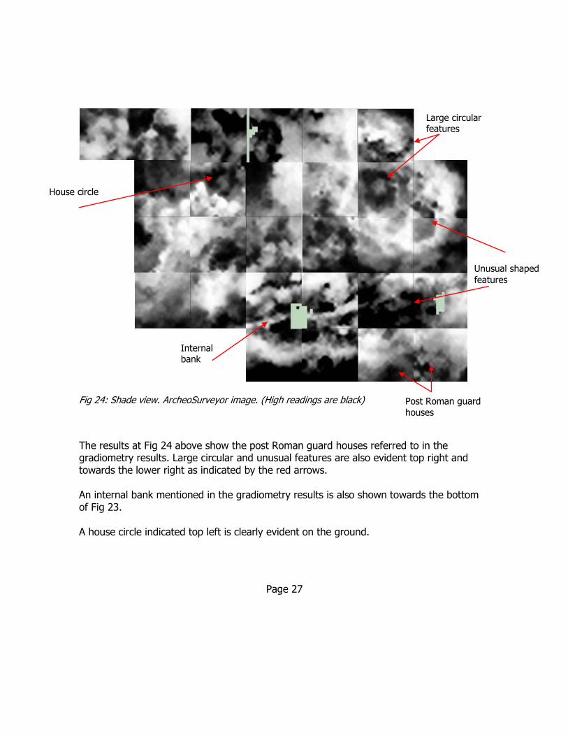
Fig 24: Shade view. ArcheoSurveyor image. (High readings are black)
The results at Fig 24 above show the post Roman guard houses referred to in the gradiometry results. Large circular and unusual features are also evident top right and towards the lower right as indicated by the red arrows. An internal bank mentioned in the gradiometry results is also shown towards the bottom of Fig 23. A house circle indicated top left is clearly evident on the ground.
Page 27
Unusual shaped
features
House circle
Large circular features
Post Roman guard
houses
Internal bank

Fig 25: Shade view. ArcheoSurveyor White green & black image image. (High readings are black)
Fig 26: Shade view. ArcheoSurveyor White green & black image image with process filters. (High readings are black)
The results shown in Fig 24 and 25 above and Fig 26 below further emphasis the wealth of features revealed. It seems likely that the results indicate a succession of structures such as round houses overlaying each other.
Page 28

Fig 27: Shade view. ArcheoSurveyor image with enhanced images of specific grids.
Page 29
Surfer image of 24 November grids with
colour chart
ArcheoSurveyor 3d
rotated white green black image of grids
for 10th November
ArcheoSurveyor 3d rotated
colour image of grid for 2nd February
ArcheoSurveyor 3d rotated colour image of
grids for 17th & 24th
November
ArcheoSurvey
3d rotated colour image
with high level pass
filter of grids
for 5th & 26 February
(grid 1 only)
Left- Surfer
image of
grid for 5th Jan & 26 Jan
grid 1 with colour scale below

The 3d image at Fig 28 above shows a number of features in a 40m by 40m area including what appear to be several linked round houses.
Page 30
Fig 28: Axonometric view. ArcheoSurveyor Red Green Blue 2 image with (right) file names and location as above

Recommendations 1) The surveys have covered a great deal of the hill fort but some areas have still to be cleared of trees, brambles etc. In view of this it is recommended that a further English Heritage licence is obtained, when such areas are cleared, in order to complete the survey. 2) Psuedosection surveys are undertaken on selected areas in order to provide more information on anomalies. 3) Further analysis of results should be made to attempt to fully interpret the geophysical results. References
Corney M. Morris N, 2004 Cadbury Hill Fort An Analytical survey by Mark Corney with Nik Morris. YCCCART 2011/Y3,North Somerset HER2011/041)
Fowler, P, Gardner, K and Rahtz, P. 1970
Cadbury Congresbury, Somerset, 1968. Bristol
Rahtz, PA, Fowler, P et al 1992 Cadbury Congresbury 1968-73. A Late/Post Roman hilltop Settlement in Somerset. British Archaeological Reports, British Series 223
Authors. YCCCART members. Date May 2012
Page 31

Appendix A Site record for gradiometry
YCCCART Site Survey
Project – Cadbury Hill Survey date 8
th March 2012
Report date 8th March 2012
Type /Instrument Grad 601
Pace :1.5m/s *
Lines/m : 1
Range:100nT
Volume: High
Sensors:2
Grid size: 30m x30m
Pattern : Zig Zag
Samples/m:4
Audio: On
Threshold:1nT
Reject:50 Hz
*Except 17th November 2011 when 1.3m/s due to ground conditions
Location Cadbury Hill
See annex A
Ref none
Site name
Landowner
Tenant
HER ref
Site type Open field
Description Grass
Period Unknown
Geology Limestone
Land use recreation
Survey team and conditions 24th February 2011 Team Peter Wright, Ferdi, Mike Fox & Ian Morton
weather cold & overcast 3rd March 2011 Team Peter Wright, Ferdi, Mike Fox, Sue Dugas & Ian Morton
weather cold & overcast 17rd March 2011 Team Peter Wright, Ferdi, Mike Fox, John Wilcock, Peter English, Sue
Dugas & Ian Morton weather Sunny and warm
28th March 2011 Team Peter Wright, Ferdi, Mike Fox, John Wilcock, Peter English, Anne
Dimmock & Ian Morton weather Overcast, cool, dry
10th November 2011 Team Peter Wright, Ferdi, John Wilcock, Janet Dickson & Ian Morton weather Sunny intervals
17th November 2011 Team Peter Wright, Ferdi, Mike Fox, John Wilcock, Peter English, Sue
Dugas & Ian Morton weather sunny
1st December 2011 Team Peter Wright, Ferdi, Mike Fox, John Wilcock, Peter English, Sue
Dugas & Ian Morton weather Overcast with light shower
8th December 2011 Team Peter Wright, Mike Fox, John Wilcock, Sue Dugas & Ian Morton weather Overcast with light shower
1st March 2012 Team Peter English, Mike Fox, Susan Dugas, Ferdi & Ian Morton weather Overcast, cool, dry
Page 32

8th March 2012 weather Peter Wright, Mike Fox, Susan Dugas, Ferdi & Ian Morton
weather Sunny intervals.
Page 33
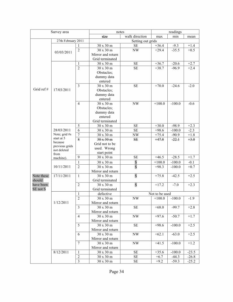
Survey area notes readings
size walk direction max min mean
Grid ref #
27th February 2011 Setting out grids
03/03/2011
1 30 x 30 m SE +36.4 -9.3 +1.4
2 30 x 30 m
Mirror and return
Grid terminated
NW +29.4 -35.5 +0.5
17/03/2011
1 30 x 30 m SE +36.7 -20.6 +2.7
2 30 x 30 m
Obstacles;
dummy data
entered
SE +38.7 -96.9 +2.4
3 30 x 30 m
Obstacles;
dummy data
entered
SE +70.0 -24.6 -2.0
4 30 x 30 m
Obstacles;
dummy data
entered
Grid terminated
NW +100.0 -100.0 -0.6
28/03/2011 Note; grid #s
start at 5
because
previous grids
not deleted
from
machine).
5 30 x 30 m SE +30.0 -98.9 +2.3
6 30 x 30 m SE +98.6 -100.0 -2.3
7 30 x 30 m NW +75.4 -90.9 +1.8
8 30 x 30 m
Grid not to be
used. Wrong
start point
SE +47.8 -22.1 +3.0
9 30 x 30 m SE +46.5 -28.5 +1.7
10/11/2011
1 30 x 30 m S +100.0 -100.0 -0.1
2 30 x 30 m
Mirror and return
S +98.3 -100.0 +0.7
Note these
should
have been
SE not S
17/11/2011 1 30 x 30 m
Grid terminated
S +75.8 -42.5 +2.5
2 30 x 30 m
Grid terminated
S +17.2 -7.0 +2.3
1/12/2011
1 defective Not to be used
2 30 x 30 m
Mirror and return
NW +100.0 -100.0 -1.9
3 30 x 30 m
Mirror and return
SE +68.0 -99.7 +2.8
4 30 x 30 m
Mirror and return
NW +97.6 -50.7 +1.7
5 30 x 30 m
Mirror and return
SE +98.6 -100.0 +2.5
6 30 x 30 m
Mirror and return
NW +62.1 -63.0 +2.5
7 30 x 30 m
Mirror and return
NW +41.5 -100.0 +1.2
8/12/2011 1 30 x 30 m SE +35.6 -100.0 -23.5
2 30 x 30 m SE +6.7 -44.3 -26.8
3 30 x 30 m SE +9.2 -59.3 -25.2
Page 34

Survey area notes readings
size walk direction max min mean
Grid ref #
8/12/2011
(cont)
4 30 x 30 m
Mirror and return SE +10.3 -30.0 -11.0
5 30 x 30 m
Mirror and return
SE +4.4 -32.0 -13.3
6 30 x 30 m
Mirror and return NW +8.1 -22.6 -11.2
7 30 x 30 m
Mirror and return
NW +10.1 -29.6 -11.9
8 30 x 30 m
Mirror and return NW +98.4 -21.4 -11.4
Grid ref #
1/03/2012
1 30 x 30 m
Mirror and return
incomplete
S +40.5 -15.5 +2.8
2 30 x 30 m
Mirror and return
incomplete
S +45.7 -100.0 -0.1
Grid ref #
8/03/2012
1 30 x 30 m
Mirror and return NW +55.3 -46.5 -1.0
2 30 x 30 m
Mirror and return NW +85.1 -96.1 -1.6
3 30 x 30 m
Mirror and return NW +56.5 -13.7 -2.2
4 30 x 30 m
Mirror and return
incomplete
NW +7.9 -9.7 -0.9
Page 35

Annex 1
Setting out details
Page 36

Grid location details
GPS
Cadbury I
location E N
A 344319.70 164960.10
B 344303.35 164984.30
C 344279.78 165006.70
D 344259.69 165026.89
E 344237.19 165044.60
M 344302.20 164942.70
N 344282.35 164963.26
O 344260.80 164984.46
P 344237.87 165005.70 ???? Suspect reading
Q 344217.60 165026.00
W 344280.45 164925.67
X 344261.27 164940.25
Y 344238.39 164963.07
Z 344218.19 164983.42
Page 37

Grid Ref. All ST
eastings northings
H 44215.14 64941.18
J 44197.00 64961.00
K 44153.14 64964.35
JJ 44173.97 64943.91
KK 44153.14 64964.35
LL 44131.28 64943.60
MM 44153.30 64921.95
NN 44131.47 64901.35
OO 44110.54 64922.90
PP 44089.82 64944.54
QQ 44110.40 64963.41
RR 44067.45 64963.86
XX 44005.00 64947.00
YY 43982.00 64927.00
64890.00
64900.00
64910.00
64920.00
64930.00
64940.00
64950.00
64960.00
64970.00
43950.00 44000.00 44050.00 44100.00 44150.00 44200.00 44250.00
Page 38

Site record for resistivity surveys – West
YCCCART Site Survey Project – Cadbury Hill Fort
Survey date 3 March 2011 to 5 May 2011 & 1st to 15th March 2012
Report date March 2012
Type /Instrument RM15
Gain x1, Current 1mA Frequency 137Hz Probes „Config 1‟ (2 probes)
Grid size: 20m x20m Pattern : Zig Zag Sample interval 1m Traverse Interval 1m. Mode Zig-Zag
Weather 3 March: Dry but overcast and grass damp 17 March: Dry and sunny 24 March: Dry & sunny 7April : Dry & sunny 11 April: Cool, overcast and grass very damp 14 April : Warm, overcast, grass damp 18 April : Warm, sunny and dry 28 April: Warm, sunny and dry 5 May: Warm and sunny. Ground very dry 1 March 2012: Sunny & warm 8 March : Overcast, warm, grass very dry 15 March: Damp, foggy
OS Ref or Lat-Longitude ST
Site name Cadbury hill fort
Landowner
Tenant Congresbury & Yatton Parish Councils
HER ref
Site type Iron Age /Post Roman
Description Hill fort
Period Unknown
Geology Oxwich Head Limestone Formation –OOIDAL LIMESTONE
Land use Public amenity
Survey team 3 March: Colin Campbell, Chris Short, Richard Baker & John Wilcox, David Long & Brian Bradbury. 17 March : Colin Campbell, Chris Short, Richard Baker, David Long & Brian Bradbury. 24 March : Colin Campbell, Chris Short, David Long & Nick Joy. 7April: Colin Campbell, Chris Short, David Long, Geoff Pearson ,Vince Russettt & Philippa Cormack. 11 April: Chris Short, Anne Dimmock, Feri, Pete Wright & Brian Bradbury Page 39

14 April : Chris Short, Pete Wright, Ian Morton, Richard Baker, Philippa Cormack, Judy and Charlotte Sack 18 April: Chris Short, Pete Wright, Colin Campbell, Ferdi and Pete English 28 April: Chris Short, Pete English, Ferdi ,Geoff Pearson, David Long, Susan Degas & Maggie Rosevink 5May : Chris Short, Pete English, Maggie Rosevink, Colin Campbell,Pete Wright, Ian Morton 1 March : Chris Short, Pete English, Colin Campbell, David Long, John Wilcox, Ferdi, Vince Russett & Philippa Cormack. 8 March: Chris Short, Colin Campbell, David Long, John Haynes, Vince Russett, Philippa Cormack & Judy Sack. 15 March: Chris Short, Colin Campbell , Judy Sack, Pete English & John Wilcox
Survey area notes
readings
size walk direction
3 March
Grid 1 Grid 2 (Part grid. Terminated by use of Finish grid (western end covered with brambles etc )
1 x 20m 1 x 20m
W W
17 March
Grid 1 Grid 2 (Part grid. Terminated by use of Finish grid
1 x 20m 1 x 20m
W W
24 March
Grid 1 (Part grid) Grid 2
1 x 20m 1 x 20m
W W
7April Grid 1 (Part grid) Grid 2
1 x 20m 1 x 20m
W W
11 April
Grid 1 Grid 2
1 x 20m 1 x 20m
W W
14 April
Grid 1 Grid 2
1 x 20m 1 x 20m
Page 40
W W

18 April
Grid 1 Grid 2 Grid 3 (Part grid & without dummy log at beginning) Not used Grid 4 Abortive Grid 5 (14 m wide grid. 6 lines of dummy data).
1 x 20m 1 x 20m
1 x 20m
1 x 20m
1 x 20m
W W
W
W
W
28 April
Grid 1 Grid 2
1 x 20m 1 x 20m
W W
5 May Grid 1 (Limited by brambles, bushes etc) Grid 2 (Abortive) Grid 2 abandoned because ground so dry machine would not register or readings exceeded maximum.
1 x 20m 1 x 20m
W W
1 March 2012
Grid 1 Grid 2
1 x 20m 1 x 20m
W W
8 March 2012
Grid 1 Grid 2 Grid 3 Grids 2 & 3 line end used to delete first 10 lines
1 x 20m 1 x 20m 1 x 20m
W W W
15 March2012
Grid 1 Grid 2
1 x 20m 1 x 20m
Page 41
W W

Summary Downloaded to : ArcheoSurveyor: Cadcong / 3Mar 1 & 2 Cadcong / 17 March 1 & 2 Cadcong / 24 March 1 & 2 Cadcong / 7 April 1 & 2 Cadcong /11 April 1 & 2 Cadcong /14 April 1 & 2 Cadcong / 18 April 1 to 5 Cadcong /28 April 1 & 2 Cadcong / 5 May 1 & 2 Cadbury / 1 March 1 & 2 Cadbury / 8 March 1,2 & 3 Cadbury /15 March 1 & 2 Snuffler: Cad 1 to 26
Page 42

Grid layout
Page 43

Page 44

Site record for resistivity surveys – East
YCCCART Site Survey Project – Cadbury Hill Fort
Survey date 20 October 2011 to 23 Feb 2012
Report date 23 February 2012
Type /Instrument RM15
Gain x1, Current 1mA Frequency 137Hz Probes „Config 1‟ (2 probes)
Grid size: 20m x20m Pattern : Zig Zag Sample interval 1m Traverse Interval 1m. Mode Zig-Zag
Weather 20 Oct: Dry and sunny 3 Nov: Overcast and grass wet 10 Nov: Sunny and warm. Grass damp 17 Nov: Sunny and warm. Grass damp 24 Nov: Overcast but dry. Grass slightly damp 1 Dec: Overcast, grass damp, slight rain shower 8 Dec: Overcast , very windy & damp 5 Jan: Very windy, mixed sun & cloud, grass wet. 12 Jan: Overcast, grass damp 26 Jan: Overcast /sunny, grass very wet, a few light showers 31 Jan: Dry, sunny cold & grass damp 2 Feb: Dry, very cold & sunny 9 & 16 Feb: Dry, sunny 21 Feb: Dry but overcast 23 Feb: Dry, overcast and grass damp
OS Ref or Lat-Longitude ST
Site name Cadbury hill fort
Landowner
Tenant Congresbury & Yatton Parish Councils
HER ref
Site type Iron Age /Post Roman
Description Hill fort
Period Unknown
Geology Oxwich Head Limestone Formation –OOIDAL LIMESTONE
Land use Public amenity
Survey team 20 Oct: Chris Short, Peter English, Colin Campbell, Ferdi, Mike Fox, Janet Dickenson, Nick Hart (ex CHERT). 3 Nov: Chris Short, Colin Campbell , Janet Dickenson, Nick Hart (ex CHERT), David Long & John Wilcox. 10 Nov: Chris Short, Colin Campbell, David Long, Vince Russett & John Haynes. Page 45
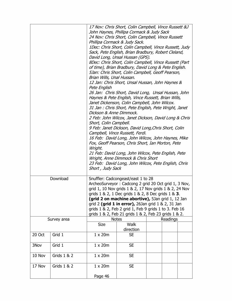
17 Nov: Chris Short, Colin Campbell, Vince Russett &J John Haynes, Phillipa Cormack & Judy Sack 24 Nov: Chris Short, Colin Campbell, Vince Russett Phillipa Cormack & Judy Sack. 1Dec: Chris Short, Colin Campbell, Vince Russett, Judy Sack, Pete English, Brian Bradbury, Robert Cleland, David Long, Unsal Hussan (GPS). 8Dec: Chris Short, Colin Campbell, Vince Russett (Part of time), Brian Bradbury, David Long & Pete English. 5Jan: Chris Short, Colin Campbell, Geoff Pearson, Brian Wills, Unal Hussan. 12 Jan: Chris Short, Unsal Hussan, John Haynes & Pete English 26 Jan: Chris Short, David Long, Unsal Hussan, John Haynes & Pete English, Vince Russett, Brian Wills, Janet Dickenson, Colin Campbell, John Wilcox. 31 Jan : Chris Short, Pete English, Pete Wright, Janet Dickson & Anne Dimmock. 2 Feb: John Wilcox, Janet Dickson, David Long & Chris Short, Colin Campbell. 9 Feb: Janet Dickson, David Long,Chris Short, Colin Campbell, Vince Russett, Ferdi. 16 Feb: David Long, John Wilcox, John Haynes, Mike Fox, Geoff Pearson, Chris Short, Ian Morton, Pete Wright. 21 Feb: David Long, John Wilcox, Pete English, Pete Wright, Anne Dimmock & Chris Short 23 Feb: David Long, John Wilcox, Pete English, Chris Short , Judy Sack
Download Snuffler: Cadcongeast/east 1 to 28 ArcheoSurveyor : Cadcong 2 grid 20 Oct grid 1, 3 Nov, grid 1, 10 Nov grids 1 & 2, 17 Nov grids 1 & 2, 24 Nov grids 1 & 2, 1 Dec grids 1 & 2, 8 Dec grids 1 & 3. (grid 2 on machine abortive), 5Jan grid 1, 12 Jan grid 2 (grid 1 in error), 26Jan grid 1 & 2, 31 Jan grids 1 & 2, Feb 2 grid 1, Feb 9 grids 1 to 3. Feb 16 grids 1 & 2, Feb 21 grids 1 & 2, Feb 23 grids 1 & 2.
Survey area Notes Readings Size Walk
direction
20 Oct Grid 1 1 x 20m
SE
3Nov Grid 1 1 x 20m
SE
10 Nov Grids 1 & 2 1 x 20m
SE
17 Nov Grids 1 & 2 1 x 20m
Page 46
SE

24 Nov Grids 1 & 2 1 x 20m
SE
1 Dec Grids 1 & 2 1 x 20m
SE
8 Dec Grids 1 & 2 (3 on machine)
1 x 20m
SE
5 Jan Grid 1 1 x 20m
SE
12 Jan Grids 1 (Abortive) & 2
1 x 20m
SE
26 Jan Grids 1 & 2 1 x 20m
SE
31 Jan Grids 1 & 2 1 x 20m SE
2 Feb Grid 1 1 x 20m
SE
9Feb Grids 1, 2 & 3 NB. End of Grid 2 dummy entries because of tree stumps &brambles. Final line – also dummy due to operation error
1 x 20m
SE
16 Feb Grids 1 & 2 1 x 20m
SE
21 Feb Grids 1 & 2 1 x 20m
SE
23 Feb Grids 1 & 2 1 x 20m
SE
Page 47

Page 48

GPS
Location Eastings Northings Eastings Northings Eastings Northings
A 344315.93 164992.80
B 344304.61 165006.54
E 344301.56 164978.37
F 344300.21 164952.46
G 344288.45 164964.50
I 344249.9 165038.1
J 344234.0 165024.4
K 344272.60 164979.52
N 344260.36 164994.48
P 344261.2 165023.6
Q 344245.7 165011.4
R 344232.13 164996.07 344232.10 164996.40
S 344245.31 164979.87
T 344256.61 164963.21
U 344216.98 164983.39 344216.50 164982.90
V 344229.32 164979.41
W 344243.62 164952.94 344244.07 164952.82
X 344202.95 164969.03 344202.00 164970.75 344201.50 164970.30
Y 344215.85 164954.33 344216.10 164955.22
Z 344229.36 164940.41
AA 344187.31 164957.78 344187.71 164956.10
BB 344202.10 164941.05 344201.09 164941.15
CC 344214.19 164926.69
DD 344228.36 164912.48
EE 344242.08 164952.44
FF 344257.71 164937.70
GG 344218.00 165011.10
HH 344205.30 164997.10
II 344189.90 164984.40
LL 344287.61 164940.50
MM 344272.44 164952.10
Several readings for same position taken as per R to BB above
Page 49

Relationship to manual survey
Page 50