world bank documentdocuments.worldbank.org/curated/en/640441485347353894/pdf/112252...sundarbans...
TRANSCRIPT
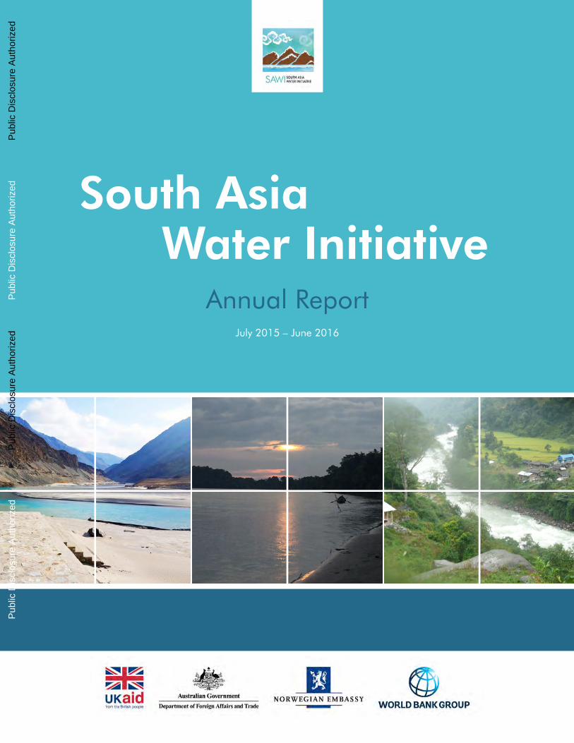
Water InitiativeSouth Asia
Annual ReportJuly 2015 – June 2016
Pub
lic D
iscl
osur
e A
utho
rized
Pub
lic D
iscl
osur
e A
utho
rized
Pub
lic D
iscl
osur
e A
utho
rized
Pub
lic D
iscl
osur
e A
utho
rized

The World Bank Group
Copyright 2017
The International Bank for Reconstruction and Development /
The World Bank Group
1818 H Street, NW
Washington, DC 20433, USA
All rights reserved
Photo Credits:
cover: Anshul Chaturvedi, Priyanka Chaturvedi, Pravin Karki
back cover: Priyanka Chaturvedi, Swapnali Bora , Ganesh Pangare
pg 9: Ganesh Pangare; pg 11: Anshul Chaturvedi; pg 12: Nandita Roy; pg 13: Priyanka Chaturvedi, SaciWaters; pg 14: BISRCI;
pg 15 Pravin Karki; pg 16: Caroline Suzman; pg 17: Priyanka Chaturvedi; pg 20: Jitendra Bajracharya/ICIMOD; pg 21: Laila
Kasuri; pg 22: Anirban Dutta; pg 23: Kees Bons; pg 26: SaciWaters; pg 27: Curt Carnemark; pg 29: IWMI; pg 30: Ganesh
Pangare; pg 32: Christina Leb
The findings, interpretations, and conclusions expressed
in this report are entirely those of the authors and should
not be attributed in any manner to the World Bank, or
its affiliated organizations, or to members of its board or
executive directors or the countries they represent. The World
Bank does not guarantee the accuracy of the data included
in this publication and accepts no responsibility whatsoever
for any consequence of their use. The boundaries, colors,
denominations, and other information shown on any map
in this volume do not imply on the part of the World Bank
Group any judgment on the legal status of any territory or the
endorsement or acceptance of such boundaries.

Water InitiativeSouth Asia
Annual ReportJuly 2015 – June 2016
Table of Contents
Acronyms and Abbreviations
Foreword
Strategic Overview
Focus Areas Summaries
Indus Basin Focus Area
Ganges Basin Focus Area
Brahmaputra Basin Focus Area
Sundarbans Landscape Focus Area
Regional Cross-Cutting Focus Area
Performance
Results
Knowledge Products
Appendices
Appendix I – Detailed Activity Descriptions
Appendix II – Financial Report
Appendix III – Risk Management
Appendix IV – Results Framework
3
4
6
19
22
25
28
30
34
41
46
61
65
67

Acronyms and Abbreviations
AE Actual ExpenditureBBIN Bangladesh, Bhutan, India and Nepal BCM Billion Cubic MetersBDP 2100 Bangladesh Delta Plan 2100BISRCI Bangladesh-India Sundarbans Regional Cooperation InitiativeBRB Brahmaputra River BasinCoP Community of PracticeCOP 21 21st Conference of Parties to the UN Framework on Climate ChangeDSS Decision Support SystemFA Focus AreaFY16 Fiscal Year 2016 (1 July 2015 – 30 June 2016)FY17 Fiscal Year 2017 (1 July 2016 – 30 June 2017)GBM Ganges-Brahmaputra-Meghna GIS Geographic Information System GRB Ganges River BasinHKH Hindu Kush HimalayaHUC Himalayan University ConsortiumICIMOD International Centre for Integrated Mountain DevelopmentIF Indus ForumIF-WG Indus Forum Working GroupIRB Indus River Basin IUCN International Union for Conservation of NatureIWMI International Water Management Institute IWRM Integrated Water Resources Management JRC Joint Rivers Commission (Bangladesh)M&E Monitoring and EvaluationMDTF Multi Donor Trust FundMoU Memorandum of UnderstandingNEA Nepal Electricity AuthorityNGMIP National Groundwater Management Improvement Program NHP National Hydrology ProjectPMKSY Pradhan Mantri Krishi Sinchayee YojanaPTA India-Nepal Power Trade AgreementRMIP River Management Improvement ProjectSAWI South Asia Water InitiativeUIB Upper Indus BasinWCAP Water Sector Capacity Building and Advisory Services ProjectWECS Water and Energy Commission Secretariat (Nepal)WEF Water and Environment Forum (Pakistan)

Foreword
Practically every development challenge of the 21st century — including food and energy security, rapid urbanization, human development, environmental protection and adaptation to climate change — requires urgent attention to the management of water resources at the regional, basin/landscape and sub-basin levels. One need look no further than through the lens of water in the South Asia region to understand the complexity in meeting these challenges.
Water availability in South Asia is highly variable. The monsoon delivers 80 percent of annual rainfall in just three months. Dry and wet years show significant climate variability. This variability is increasing because of climate change. Water resources are underdeveloped and often poorly managed. Much of the region’s hydropower potential is untapped. River navigation is largely undeveloped. System storage capacity is low, and river ecosystems are significantly degraded. Water supply and sanitation services are inadequate in many areas. Population growth and economic development are placing increasing demands on water resources in South Asia. Approximately 250 million people in the region live on less than US$1.90 a day. This represents about one-third of the world’s poor. The poor are most at risk from floods and droughts and inadequate water and sanitation services. At least half the vulnerable poor in South Asia live in transboundary river basins, where achieving water security across all riparian countries will require enhanced cooperation.
Sustainably developing and managing the region’s water resources requires better water data and information to guide infrastructure planning, investments, and asset management. Enhanced transboundary cooperation will require greater sharing of water information and strong national and international institutions. To achieve this requires building trust between riparian countries.
The World Bank is proud to host the South Asia Water Initiative (SAWI), which is facilitating these outcomes by supporting capacity development, promoting dialogue, undertaking analyses to guide water management, and disseminating best practice to inform the design of important new water sector investments. SAWI is currently in its second phase (2013-2017), which is funded through a multi-donor trust fund financed by the governments of the United Kingdom, Australia and Norway. The development objective of SAWI is to increase regional cooperation in the management of the major Himalayan river systems to deliver sustainable, fair and inclusive development in addition to climate resilience.
This annual report describes SAWI’s progress, results and outcomes for fiscal year 2016 (July 1, 2015 – June 30, 2016) and presents the future direction of SAWI. I am happy to note the accelerated implementation progress of SAWI in the past year. As implementation progresses and activities are completed, the contribution of SAWI to increased transboundary water management becomes increasingly apparent. South Asia is a vast and diverse region and transboundary water management is complex and highly political. Although SAWI is a modest investment relative to the water challenges of South Asia, strategic investments are sowing the seeds for increased cooperation that are expected to yield significant results over time. The World Bank thanks the donors for their continued support, and looks forward to continuing to work collaboratively to strengthen cooperative water management in South Asia.
Akihiko NishioDirector, Strategy and Operations World Bank — South Asia Region

Strategic Overview

6
Strategic Overview
Stra
tegi
c O
verv
iew
This report describes and analyzes progress of the South Asia Water Initiative (SAWI) in fiscal year 2016 (July 2015 through June 2016). SAWI supports increased regional cooperation in the management of the major Himalayan river systems in South Asia to deliver sustainable, fair and inclusive development and climate resilience. The major Himalayan river systems — the Indus, Ganges and Brahmaputra — span multiple countries (Afghanistan, Bangladesh, Bhutan, China, India, Nepal, and Pakistan), landscapes (mountains, valleys, lowlands, and deltas) and cultures. SAWI therefore works across basins and countries to support knowledge generation and sharing, capacity development, dialogue, participatory decision processes, and investment designs. In the context of water resources planning and management, SAWI promotes poverty alleviation, economic development, gender
inclusion, and climate change adaptation. SAWI is currently in its second five-year phase (2012-2017). This phase consists of a US$31 million Multi-Donor Trust Fund (MDTF) that is financed by the governments of the United Kingdom, Australia and Norway.
FY16 was an important year for SAWI as implementation accelerated with many new activities launched and several activities successfully completed. As implementation progresses, SAWI is starting to show results. Dialogue is connecting water professionals across the region at technical levels and increasingly at policy and political levels. While water cooperation in South Asia remains uneven and politically sensitive, SAWI is supporting a subtle change in mindsets and creating new opportunities for future reforms and investment.

7
Sout
h A
sia
Wat
er In
itiat
ive
Activities, Outputs and Outcomes
The majority of SAWI resources has been allocated. Thirty-four activities were under implementation during FY16 and five activities were completed. FY16 expenditure was US$6.20 million. At the end of the fiscal year, approximately 35 percent of the total SAWI funding envelope has been disbursed and another 22 percent was contractually committed. The apparent predominance of knowledge activities is somewhat misleading as the major activities in this category have significant capacity building components and also work to build trust and confidence. The preponderance of
national scale work reflects both the importance of interfacing with Bank investment lending (which in the water sector is all national), and the fact that no requests for transboundary analysis or other work has been received given the sensitivity of these issues. The larger investment in the Ganges reflects the greater opportunity to connect with major Bank investment operations (current and pipeline) in both India and Nepal, and the fact that it is, by far, the most populated of the three basins. The FY16 distribution of investments across result areas, geographic scope and focus areas is shown in the charts below.
Nearly all FY16 program-level targets in the results framework were achieved. The largest investment was in generating and sharing knowledge. Twenty-five new knowledge products were completed. The second largest investment was in building institutional capacity. SAWI helped strengthen over sixty water management organizations in areas relevant to basin-scale planning or regional cooperation and supported training of nearly four hundred water professionals in water management, water policy, and water diplomacy. A dozen feasibility studies for World Bank investment were informed by SAWI analytical work.
SAWI supported eight participatory processes that facilitated transboundary knowledge generation and sharing of stakeholder inputs to government decision-making.
As implementation progresses and activities are completed, SAWI’s contribution to increased transboundary water management becomes increasingly apparent. South Asia is a vast and diverse region and home to one-quarter of the world’s population. Transboundary water management is complex and highly political. Although SAWI represents only a modest
Results Areas Geographic Scope Focus Areas
Building Instituional Capacity
Generating and Sharing Knowledge
Scoping Interventions
Building Trust and Confidence
National
Bilateral
Basin
Regional
IndusGangesBrahmaputraSundarbansRegional

8
investment relative to the scale of water challenges of South Asia, strategic investments are sowing the seeds for increased cooperation that are expected to yield significant results over time. Subtle shifts in entrenched positions, including on data and information accessibility and participation in regional water forums, signal a willingness to focus on future opportunities rather than the difficulties of the past.
SAWI activities are being implemented in, and are contributing to, an environment where there is increasing acceptance that greater regional cooperation is important for economic development and regional stability. The discourse on regional cooperation is expanding from trade, transport and energy security, to the consideration of water resources management. River connectivity underpins shared ecological integrity that provides ecological goods and services that are critical to the well-being of the poorest and most vulnerable South Asians. This reflects a growing acceptance by governments that water security is critical to economic development but cannot be achieved by operating within national borders.
The entry points for transboundary waters are shifting. While water sharing remains sensitive, navigation, joint river basin management for flood mitigation, power trade, climate change and ecological integrity offer new entry points for dialogue. River connectivity underpins the shared ecological integrity required to provide services that are critical to the well-being of people in South Asia. SAWI is also using the preparation of World Bank lending operations as an entry point to consider transboundary and basin-scale issues.
A shift toward sub-regional cooperation has been observed, reflecting the geopolitical differences between the east and the west of the region. While significant tensions remain in the western sub-region, in the eastern sub-region, there is renewed confidence in the Bangladesh-Bhutan-India-Nepal (BBIN) process. Momentum is building around implementation of the Sundarbans joint agreements between India and Bangladesh.
Bilateral power trade agreements for export of hydropower have been an important focus in bilateral water cooperation, including between Afghanistan and Pakistan, between Nepal and India, and between Bhutan and India.
Progress by Result Area
SAWI activities build trust and confidence, generate and share knowledge, build institutional capacity, and scope interventions and investments. In the graph on the previous page, each activity has been mapped to a single result area on the basis of its primary outcome which shows the budget allocated to activities. In reality, many activities contribute to multiple outcomes. All activities are designed to contribute directly or indirectly to building trust and confidence for regional cooperation. For instance, in the Sundarbans, greater cooperation has been fostered through the establishment of a joint platform for formal participation of the governments of India and Bangladesh in long-term planning. This is accompanied by joint environmental studies and joint design for a landscape-scale environmental monitoring systems. This growing collaboration is both a result of, and a contribution to, increasing the trust and establishing working bilateral relationships.
The budget allocation for activities primarily focused on building trust and confidence is relatively small given the nature of these activities (mainly dialogue processes). SAWI’s approach has been to first build trust and confidence amongst technical stakeholders. Increasingly, and building on the technocratic networks SAWI helped establish, activities are engaging at the policy and political levels. Dialogues also open up government-dominated water management to participatory multi-stakeholder processes from the local to the river basin level. This incremental and bottom-up approach takes time, but has demonstrated its effectiveness. A good example is the recent South Asia Groundwater Forum which was the first-ever significant regional water event with participation from the Government of India. The forum elevated the importance of groundwater for economic development in the region to the political level.
Stra
tegi
c O
verv
iew

9
Sout
h A
sia
Wat
er In
itiat
ive
Elevating the Regional Goundwater Dialogue
A South Asia Groundwater Forum was organized by the Government of India, the World Bank, and the International Water Association in May 2016. The Forum was the first-ever significant regional water event with participation from the Government of India. The forum brought together more than 125 delegates from all countries in the region as well as experts from beyond the region, including current and former ministers, senior bureaucrats, water practitioners and scientists. The forum elevated to
the political level the importance of groundwater for economic development in the region. The forum’s scope and success was made possible by the considerable investment in technical activities with various stakeholders financed by SAWI.
A large part of the activities supported by SAWI is dedicated to the generation and dissemination of knowledge, and the development of technical tools and methods for cooperative water management. These, in turn, strengthen the technical foundation for landscape, basin, sub-regional and regional discourse.
Analytical work on technical issues such as flood forecasting technologies and sediment management for hydropower have provided detailed information on opportunities for basin-level cooperative action. The implementation and joint review of the analytical work has proven to be an important tool for confidence-building between technocrats, as it is seen as a safe area for cooperation. In addition, results are starting to inform policy and decision-making. Analytical work ranges from a region-wide inventory on climate change risks in water resources management to bilateral work on the potential for coordinated development of the hydropower in the Kunar River Basin (Afghanistan/Pakistan).
Institutional capacity building has focused on both skills for successful transboundary water negotiation and technical knowledge for sound river basin management. At the political and institutional end of the spectrum, government officials from various national institutions have been trained on transboundary water governance
and hydro-diplomacy to facilitate more effective and balanced negotiations. At the technical end of the spectrum, capacity building has focused on hydro-meteorological instrumentation, river basin modeling, water quality monitoring and analysis, and groundwater management.
Support for scoping interventions by injecting robust science and international best practice into decision-making processes represents a considerable part of SAWI activities. For instance, during the last year, significant progress was made on the Ganges Strategic Basin Planning activity with the initial development of a basin modeling framework, the identification of key water management issues, and the identification of available data. The river basin planning is mainly focused on India, given political sensitivities, but the modeling will necessarily encompass all basin areas upstream of India, and will ensure that basin-wide data are made available to all basin stakeholders. The development of the basin modeling framework involved consultation with nearly five hundred stakeholders. This activity is now being viewed by the Government of India as an important pilot for the river basin planning work they plan to conduct across all major river basins of the country with financing from the World Bank-financed National Hydrology Project (under preparation).

10
Progress by Geographic Scope
SAWI is supporting regional and basin-wide activities as well as national scale activities that build the support and confidence of national governments to engage in constructive regional dialogue as a precursor to more formal future cooperation. Analytical and knowledge-focused activities range from national scale (e.g., to ensure transboundary and basin-scale issues are adequately considered in World Bank water sector investments), through river basin scale (e.g., to guide cooperative planning) up to regional scale (e.g., to promote climate change adaptation). Similarly, capacity building ranges from national efforts in response to specific government requests or tailored to specific issues (e.g. sediment management in hydropower), up to regional activities on shared challenges and needs. National level capacity building is directed towards addressing the capacity asymmetry that often makes riparian interactions less effective. Dialogue activities are either basin or regional in scope. The national level work provides the knowledge and
capacity “pillars” for basin and regional-level dialogue on transboundary water governance and cooperation. These national-focused activities are often related, and their inclusion under the SAWI umbrella allows for exchange and cooperation across boundaries and across activities. For instance, various national-focused activities in Bangladesh, Bhutan and India support governments to enhance hydro-meteorological data collection and management. These national activities provide the building blocks of basin/landscape-level information systems, as are being explored for example, for the Sundarbans and the entire Brahmaputra Basin.
Progress by Focus Area
SAWI is structured around four geographic Focus Areas (Indus Basin, Ganges Basin, Brahmaputra Basin, and Sundarbans Landscape) interfacing with a Regional Cross-cutting Focus Area that supports work that is not national or basin-specific in orientation.
Cross-cutting knowledge, dialogue and cooperationbuild knowledge and capacity across the region in support of
transboundary basin-focused dialogue and cooperation
Indus Basinstrengthen water resources management and coordination
between countries to improve water and energy security
Brahmaputra Basinimprove shared understanding and management in order
to strengthen resilience & support economic growth
Sundarbans Landscapeoperationalize joint management of the Sundarbans for
sustainable development and to deliver mutual benefits for the two countries
Ganges Basinimprove shared understanding, management &
development, to support economic growth & resilience to climate variability & change
Indus Basin In the Indus Basin, SAWI helps strengthen water resources management and coordination among riparian countries to improve water and energy security. This includes support to long-term basin development and investment planning and capacity building for water and energy security. Highlights from the last year include:
• An assessment was completed of the potential for hydropower cascade development in the Kunar River Basin that spans Afghanistan and Pakistan. The assessment considers the technical feasibility of hydropower development under different operational and climate scenarios as well as institutional and policy
Stra
tegi
c O
verv
iew

11
Sout
h A
sia
Wat
er In
itiat
ive
issues. In spite of severe energy insecurity in both countries, the interest of the two riparians in joint development is asymmetric.
• A capacity building program was implemented for government officials in Afghanistan on how to conduct meaningful dialogue on the management and development of shared water resources.
• Participants of the four-country Indus Forum dialogue agreed to expand and connect with more regional institutions and development partners to create an enabling environment for basin cooperation. This positive step for increased engagement and influence
of the Indus Forum was an outcome of the International Conference on Climate and Environment Change Impacts on the Indus Basin Waters, which was organized jointly with regional knowledge partners.
• SAWI supported analytical work that helped ensure that transboundary aspects of water management were incorporated into project designs in the additional financing of World Bank-financed water sector projects in Afghanistan (Irrigation Rehabilitation and Development, US$70 million) and in Pakistan (Water Sector Capacity Building and Advisory Services, US$35 million).
Capacity Building for the Government of Afghanistan
Experience indicates that countries with well-coordinated national structures can more effectively engage in cross-border dialogue and negotiations. SAWI supported transboundary waters training to meet the needs of the Afghan ministries of Energy and Water, Foreign Affairs, and Finance. Twenty-seven officials were trained across nine workshops (over 100 hours) on prior notification, information and data exchange for transboundary water arrangements, international water law, negotiation, and water diplomacy. The training informed the design of a high-level commission on transboundary water issues (chaired by the President of Afghanistan). Each line ministry formed a transboundary unit and ministry officials meet regularly through a new Transboundary Inter-Ministerial Working Group of the three ministries. The capacity building also informed the design of the country’s new Transboundary Water Policy.
Confluence of the Indus and the Zanskar, Leh, India

12
Ganges Basin In the Ganges Basin, SAWI is improving the shared understanding, management and development of the basin for economic growth and resilience to climate variability and change. This includes support to valuing the environment and ecosystem services and moving from data to information services. Highlights from the last year include:
• Technical assistance for river basin planning created an important new technically-focused forum for inter-state dialogue between the eleven Indian states in the Ganges Basin. Consultations raised stakeholder awareness of
basin planning processes and brought together perspectives from various stakeholders. Analytical methods and modeling frameworks were established as the basis for scenario development and analysis in the coming year.
• In Nepal, SAWI supports river basin planning and water resource reforms to guide environmentally sustainable hydropower development that considers downstream water demands and social and environmental values. These activities are co-financed by IDA.
• Capacity development included six training workshops for about 250 state and central government officials in India on hydro-meteorological instrumentation and integrated water resources management (IWRM) modeling tools. Work commenced to strengthen flood forecasting capacity in Bihar via a workshop that shared findings from SAWI analytical studies and assessed training requirements for improved flood forecasting. Officials of the Nepal Electricity Authority (NEA) and other Nepalese government departments were trained in watershed modeling and ecosystem modeling for sustainable hydropower development. Enhanced technical capacity in both countries is building the foundation for improved water resources planning and management and greater awareness of the need for basin scale analysis and decision making.
Informing Water Resources Software Choices
SAWI supported the documentation of the role of modeling software in water resources management, and identified and reviewed models and software. There are diverse water resource models and software available, but choosing the most appropriate software is difficult for water managers with limited experience, as is common in South Asia. The SAWI review considers models for water allocation and planning, flood management, groundwater management, conjunctive use, water quality management, and sediment management. The review will help water managers make more informed software choices in the context of data and capacity constraints and institutional setting. This activity informed the World Bank-financed National Hydrology Project and will support improved river basin management and flood management across South Asia.
Stra
tegi
c O
verv
iew
Vidyasagar Setu on the Hooghly River, Kolkata, India

13
Sout
h A
sia
Wat
er In
itiat
ive
Brahmaputra Basin In the Brahmaputra Basin, SAWI has improved the shared understanding and management of the basin as a means to strengthen resilience and support economic growth for the riparian countries. This includes knowledge and capacity building for basin management and investment planning, and support for reducing vulnerability to floods and erosion. Highlights from the last year include:
• The Brahmaputra Dialogue forum of policymakers, academics and opinion leaders from Bangladesh, Bhutan, China and India built considerable momentum towards cooperation on basin management.
• In November 2015 a delegation of senior officials from Bangladesh and Bhutan visited the Mississippi River and the multiple
organizations involved in its management (including the Mississippi River Commission and the US Army Corps of Engineers) to learn about management of rivers that cross administrative boundaries, and to discuss management options for the Brahmaputra.
• A training workshop on international good practice in managing the environment and social impacts of hydropower development, including basin-scale planning and cumulative impact assessments, was held in February 2016 in Bhutan for the National Environmental Commission. Participants were trained on how to ensure hydropower planning takes account of downstream, cross-border issues, in addition to being environmentally sustainable and socially acceptable at a national scale.
• The design of investments for improved river and delta management was strengthened by: (i) a study of dredging options for improved navigability and river training in Bangladesh in the context of basin-wide flood and erosion risks; (ii) a scoping study for modernizing weather, water and climate services in Bhutan; and (iii) identification of investment and management options for the two-country Ganges-Brahmaputra-Meghna Delta based on adaptive delta management principles.
Brahmaputra Dialogue
In 2013, the Indian NGO SaciWaters (South Asia Consortium for Interdisciplinary Water Resources Studies) created a platform for India and Bangladesh to discuss the challenges and opportunities of joint management of the Brahmaputra Basin. Early engagements led to a recognition of the importance of a four-country dialogue on the Brahmaputra, and the recommendation to engage government officials. From 2015, SAWI has supported the dialogue process, which has matured to focus on
development of a basin-level governance framework. In FY16, country-level workshops in Bangladesh and China (on knowledge sharing, economic opportunities and disaster management) helped build ownership of the process, and an Advisory Committee (from Bhutan, Bangladesh and India) was constituted to support drafting a basin-level institutional framework and to support organization of a regional workshop in FY17. A review of transboundary protocols/treaties/accords has commenced to guide the design of institutional agreements for basin management, and a mapping of key government departments across all countries will improve coordination among the riparian governments.
Traditonal Boat on the Brahmaputra River, Guwahati, India

14
Sundarbans Landscape In the Sundarbans Landscape, SAWI helps to operationalize joint management for sustainable development and to deliver mutual benefits for India and Bangladesh. This includes enhancing bilateral and technical cooperation to support joint management. Highlights from the last year include:
• The Bangladesh-India Sundarbans Regional Cooperation Initiative (BISRCI) was established as a two-country multi-stakeholder dialogue forum of policy think tanks, civil society organizations. Through its Sundarbans Landscape event at Conference of Parties
(COP)-21 in Paris, over 100 delegates attended. Strong media engagement has helped community-level stories reach national and international audiences, greatly raising awareness of Sundarbans challenges (see box below).
• Other important dialogue and knowledge events during the year, supported by key partners, World Wildlife Fund (WWF) and International Union for Conservation of Nature (IUCN), included an international workshop on delta resilience, media workshops to draft a bilateral media collaboration plan, three government-to-government meetings on landscape cooperation, and two sessions of the West Bengal State Assembly discussing landscape development and cooperation with Bangladesh. Direct support to government officials ensured Sundarbans issues were prominent during the 6th India-Bangladesh Friendship Dialogue that led to the adoption of a “Delhi Declaration” recommending increased connectivity through revival of inland waterways and integrated water resources management.
Highlighting the Sundarbans’ Vulnerability
BISRCI aims to raise the global profile of the Sundarbans and its climate change challenges, and to support bilateral Sundarbans cooperation. Hosted at the Government of India pavilion at COP 21, the Climate Change Adaptation in Coastal Areas and Other Sectors: Experience from the Sundarbans Region event attracted more than 100 delegates including civil society organization members, journalists, think tank researchers, developed country government officials and negotiators, and policymakers from Bangladesh and India. The environment ministers from both India and
Bangladesh participated – marking the first time the two countries have discussed the Sundarbans at an international event – and publically committed to bilateral cooperation. The event was a success because of meticulous preparation by BISRCI partners through several meetings with key ministries in Bangladesh and India prior to COP 21 stressing the importance of ministerial participation from both countries at the event and the need for a joint statement.
Stra
tegi
c O
verv
iew
Environment Ministers from India (Mr. Prakash Javadekar, left) and Bangladesh (Mr. Anwar Hossain, right) at the Paris COP 21 Side Event
River embankments in the Sundarbans are vulnerable to frequent floods

15
Sout
h A
sia
Wat
er In
itiat
ive
Decision-making Under Uncertainty
Hydropower is critical to eliminating energy deficits in South Asia in a sustainable and affordable manner. The design of hydropower projects must consider the potential consequences of complex regional scale climate processes given the uncertain impact on the complex Himalayan hydrology and already high sediment loads. A decision tree analysis method was piloted to identify the impact of climate change on the Upper Arun hydropower project in Nepal. The analysis
showed a larger than expected generation capacity would potentially be the most economically efficient design robust to climate uncertainty. The analysis considered sediment management and snow and glacier contributions to current and future streamflow. Additional analysis for the entire Kosi Basin demonstrated the utility of the method to systematically incorporate climate and non-climate uncertainties when assessing proposed water infrastructure as a component of basin-scale planning. The method was found to be cost-effective and scientifically sound and is replicable to transparently consider a range of risks typical for high-value hydropower development in South Asia.
Regional Cross-Cutting ActivitiesSAWI, through its regional cross-cutting focus area, is supporting knowledge and capacity generation and supporting transboundary basin-focused dialogue and cooperation. Highlights from the last year include:
• Substantive analytical work on flood forecasting was completed including development of an innovative forecasting method based on remote sensing that helps address the scarcity of ground-based observations in the region. Other activities include: (i) an assessment and mapping of flood risks across the entire Ganges Basin was completed and presented in a Ganges Flood Risk Atlas that is now hosted on the Indian Central Water Commission website; and (ii) a Regional Flood Forecasting Workshop — hosted by the Regional Integrated Multi-Hazard Early Warning System (a regional intergovernmental capacity building institution) — provided training for government professionals from Bangladesh, Bhutan, India and Nepal. At the workshop the UN Economic and Social Commission for Asia and the Pacific agreed to support further training in the new approaches shared at the workshop under the auspices of its proposed Intergovernmental Panel on Transboundary Flood Management.
• Studies on climate change risk screening and integrating resilience into hydropower development included a demonstration application of a “decision tree” model for decision making under uncertainty to the Upper Arun Hydropower Project (UAHP) in eastern Nepal and to the entire Kosi Basin. The work demonstrated the regional applicability of the approaches and identified project alternatives for Upper Arun that might prove more economically attractive under climate change. The application of the model showed its relevance to inform hydropower development across South Asia.
• A two-year capacity building program on water diplomacy and water governance requested by the Bangladesh Ministry of Water Resources trained 15 government officials on water resources management, water diplomacy and international water law, and conflict management. Eight senior Indian officials and decision makers visited France and the Netherlands to learn good practice in transboundary river basin planning and management. Customized training in groundwater modeling was delivered to fill a critical capacity gap in India.
Aerial view of the Arun River, Nepal

16
Gender Mainstreaming
Reporting for the 2016 FY shows a moderate level of participation by women in the various SAWI capacity building and dialogue events. The moderate level of participation reflects the generally low level of participation of women in technical water management roles in the region. Women were given prominent leadership roles in the various conferences, workshops, and dialogue events convened. A gender plan for SAWI is under development to provide a more structured approach to explicitly capturing gender issues in activity design and to improve tracking and reporting of gender issues. The strategy considers both outcomes from improved transboundary water management as well as the processes of water governance at multiple levels through a gender lens. Future work will look at providing training opportunities that target women at all levels of water management and will ensure explicit consideration of gender-specific issues in ongoing river basin analysis and modeling work.
Partnerships
SAWI activities are carried out in close partnership with national, regional, and global partners. These partnerships ensure the sustainability of SAWI activities, including beyond the duration of the program. They also help in crowding in knowledge and disseminating knowledge to multiple stakeholder groups. National authorities in riparian countries are involved in all SAWI activities. Wherever possible, SAWI uses an existing platform for dialogue. Most events are organized in collaboration with partners. Policy think tanks, civil society organizations and academics are active participants in the knowledge generation. Sometimes the modality of this is the execution of an activity through an external implementing agency. In other cases, knowledge institutions are contracted as consultants. However, the majority of partnerships are not contractual in nature but congregate partners around common themes and interests. SAWI has supported the strengthening of existing multi-stakeholder dialogue forums (such as BISRCI) and helped establish others (for instance the Pakistan Water and Environment Forum). Global and regional knowledge institutions, including International Water Management Institute (IWMI), International Centre for Integrated Mountain Development (ICIMOD), United Nations Educational, Scientific and Cultural Organization-Institute for Water Education (UNESCO-IHE), Indian Institute of Technology (ITT)-Roorkee also form an important group of partners in SAWI activities as do professional associations (such as the International Water Association). Partnerships with development partners, including but not limited to the governments of the United Kingdom, Australia and Norway that finance SAWI, help to ensure complementarity, avoid overlaps, and influence donor-financed programs in the region.
The Year Ahead
SAWI has established a rich portfolio of activities designed to foster regional cooperation in the management of the major Himalayan river systems in South Asia. SAWI is now entering a
Stra
tegi
c O
verv
iew Women fetch water from the artesian well, Pakistan

17
Sout
h A
sia
Wat
er In
itiat
ive
new phase which will require a focus on adaptive management, quality assurance, dissemination, and using data and evidence to inform policy dialogue.
In recognition of the dynamic political economy of the region, SAWI will adopt an adaptive management approach to ensure that SAWI is flexibly managed. The biggest risk to delivering deep impact remains the risk of government disengagement given the underlying political sensitivity of water cooperation in South Asia. Ongoing portfolio monitoring will help to identify opportunities to redirect funds from activities that do not progress or show the potential for deep impact. This will ensure that sufficient funds are available to address evolving thematic priorities that have traction with various regional stakeholders and to quickly react to emerging sub-regional political windows of opportunity.
In the coming year, the priority is shifting from the generation of new activities to quality assurance of activities and dissemination of findings. World Bank quality assurance processes apply to all SAWI outputs. Special effort will be made to share results of activities in partnership with national authorities across various countries. A focus for the year ahead is to ensure that findings are used to inform dialogue on transboundary water issues, operational water management and planning, and policy development and investments. The incremental and bottom-up approach to first build trust and confidence between technical stakeholders followed by engagement at the policy and political levels will be continued.
Implementation progress to-date provides a sound basis to extend SAWI’s impact. A no-cost extension of the trust fund beyond 2017 is under discussion with donors. An independent review is expected to be commissioned in the coming year to inform this extension and any future potential donor investment in regional water cooperation.
Boat repair, Sundarbans

Focus Area Summaries

19
Sout
h A
sia
Wat
er In
itiat
ive
The Indus River Basin, with high glacier dependency and growing per capita water scarcity, is one of the most at-risk basins in Asia. Glacier and snow meltwater contribute more than 40 percent of the average annual flow. Climate change is expected to significantly change the hydrological regime of the basin, with potentially severe impacts for the basin population. The average annual flow for the Indus River Delta has been significantly reduced because of irrigation diversions upstream. Improved water management and new investments (for water storage and hydropower generation) are needed to achieve water and energy security for Pakistan’s growing population, nearly all of which is dependent on the Indus.
Given the World Bank’s role in the 1960 Indus Waters Treaty, neutrality and complete transparency
are important for SAWI’s engagement in the Indus River Basin. The investment of SAWI resources in this Focus Area (FA) is less than in the others, and restricted to issues that are outside the purview of the Indus Waters Treaty. Activities center on strengthening water resources management and coordination between riparian countries to improve water and energy security, especially where client demand is clear. Activities include: (1) capacity building for cross-border dialogue in the Kunar River Basin (a tributary of the Indus shared by Afghanistan and Pakistan); (2) technical assistance on water resource management in transboundary basins at the inter-provincial/state and national levels; and (3) basin-level dialogue. In FY16, three activities were under implementation for which US$610,105 was expensed. All Focus Area targets in the results framework for FY16 were exceeded.
Indus Basin Focus Area

20
Building Trust and Confidence
The fragility of post-conflict Afghanistan, relationships and capacity asymmetry between riparian countries, and limited data availability in the Upper Indus Basin pose challenges for regional cooperation in water resources management in the Indus River Basin. SAWI has supported the Indus Forum, a four-country basin-level dialogue, since 2013. This year, SAWI supported the International Conference on Climate and Environment Change Impacts on the Indus Basin Waters that was jointly organized by the International Centre for Integrated Mountain Development, the International Water Management Institute and the World Bank. The conference brought together more than 80 researchers, policymakers, journalists, and practitioners from Indus River Basin countries, together with international experts and donor partners. The conference improved the shared understanding of ongoing research and interventions related to climate change and adaptation, the cryosphere, and current and future trends in water demand in the basin. The conference enabled Indus Forum participants and members of the ICIMOD-facilitated Upper Indus Basin (UIB) Initiative (a consortium of research institutions and government agencies engaged in glacier research in the UIB), to explore synergies and to identify opportunities for coordinated effort.
Indus Forum participants invited ICIMOD and IWMI to join the partnership as co-facilitators. It was agreed the Indus Forum should perform two key functions: (1) influence policy and research; and (2) coordinate and integrate projects, programs
and research. The agreement is a step forward in creating an enabling environment for cooperation at the basin level, and is expected to increase the Indus Forum’s impact by strengthening it as a credible mechanism to assemble policymakers, researchers and opinion leaders across the four countries.
At the national level, the Pakistan Water and Environment Forum (WEF) and the Pakistan Meteorological Department launched a national awareness and dialogue campaign on climate change challenges. WEF emerged from SAWI-supported regional and basin-level dialogue processes as a national platform for multiple actors in Pakistan’s water sector to promote sustainable water resources management. As part of this campaign, WEF, with SAWI support, is preparing a national climate change conference planned for October 2016. The conference will assemble national and international partners to raise awareness of climate change impacts in the Indus River Basin and the likely water and environmental impacts for Pakistan. The conference aims to improve coordination across provincial boundaries within Pakistan in order to strengthen transboundary water management at the national level.
Generating and Sharing Knowledge
The Indus Forum Working Group (IF-WG)— constituted at the 3rd Indus Forum meeting in Lahore in March 2015, with participants from the four riparian countries and the World Bank—advanced two knowledge activities during FY16. First, it continued the process to develop a joint research project on climate change impacts. Second, it guided young researchers from three basin countries in a comprehensive knowledge mapping for the Indus glaciers. The output of this first-of-its-kind knowledge mapping will be made publicly available as a Geographic Information System (GIS)-based mapping tool on the IWMI and ICIMOD knowledge portals, and will be published in a comprehensive report. It identifies the available data for Indus River Basin glaciated areas as well as knowledge gaps.
Focu
s A
rea
Sum
mar
ies
Mr. Hafiz Hafeez ur Rehman, Chief Minister of Gilgit-Baltistan, Pakistan

21
Sout
h A
sia
Wat
er In
itiat
ive
SAWI supported a series of assessments that considered the likely benefits and costs of potential hydropower cascade development in the Kunar River Basin, either as a joint effort of Afghanistan and Pakistan or as coordinated efforts by the individual countries. The assessments also indicate technical feasibility under a range of operational and climate scenarios; outline institutional and policy considerations; and suggest next steps for cooperative development.
Building Institutional Capacity
At government’s request a capacity building program was delivered for the Government of Afghanistan on transboundary water resources management. Twenty-seven government staff were trained across nine events in international water law, notification processes, negotiation, benefit sharing, and data and information sharing on exchange in transboundary basins derived from the international experience and best practice. The capacity building enhanced inter-ministerial coordination to ensure effective information flow between ministries engaged in transboundary water negotiations with neighboring countries, and helped institutionalize inter-ministerial coordination. This tailored capacity building program helped prepare officials for high-level riparian dialogue, and helped improve coordination between Afghanistan and Pakistan on the development potential of the Kunar River Basin. Similar support will be extended to Pakistan if requested, and assistance provided for joint dialogue if required.
Scoping Interventions and Investments
SAWI support helped ensure that the additional financing (US$70 million) of the World Bank’s Afghanistan Irrigation Development and Rehabilitation Project addressed, in a more comprehensive way, the needs of the Afghan water sector and increases its focus on river transboundary basin management. The additional financing will support the newly established transboundary unit in the Afghanistan Ministry of Energy and Water and the technical secretariat of the Afghanistan Supreme Council of Land and Water to help institutionalize transboundary river basin management and water governance. SAWI also provides support to the Government of Afghanistan to identify development opportunities in the Kunar River Basin, including opportunities for coordinated development of hydropower. Initial basin assessments provide the analytical underpinning for this engagement and provide a foundation for future national or joint studies of hydropower cascade development, rather than being a definitive guide for investment planning. SAWI support helped ensure a focus on transboundary management between provinces in the additional financing (US$35 million) of the Pakistan Water Sector Capacity Building and Advisory Services Project.
Indus River near Tarbela Dam, Pakistan

22
Countries seldom effectively cooperate on transboundary basin management when basins are not well managed at the national level. In South Asia, river basin management is in its infancy. In the Ganges River Basin, activities focus on national support for river basin planning in India and Nepal. These efforts are linked through dialogue processes and capacity building. Strengthening river basin planning in India is especially important for two reasons. First, India has many inter-state river basins that have been the focus of extended water disputes. Second, India is the largest country in the Ganges River Basin. The prospects of greater water cooperation between riparian neighbors will be enhanced by building awareness across Indian water management institutions of the benefits of basin-scale planning and management. In Nepal, sustainable development of significant hydropower resources requires a basin planning approach to assess and manage the sharing
of hydropower benefits, to assess and mitigate cumulative environmental impacts from multiple projects, and to inform trade-offs between water uses and users. In FY16, eight activities were under implementation with an aggregate expenditure of US$1,585,739. All but one of the FA targets in the results framework for FY16 were exceeded. The basin dialogue process was on hold in FY16 to allow related activities to build momentum.
Ganges Basin Focus Area
Focu
s A
rea
Sum
mar
ies
The Ganges River in Varanasi, India

23
Sout
h A
sia
Wat
er In
itiat
ive
Building Trust and Confidence
In India and Nepal, there is growing acceptance of the need for new or revised policy and legislation to enable water resources management on a river basin basis. In India, a national river basin management bill has been drafted, and consultations with selected states and the broader public have been conducted to guide the design of the legislation. When enacted, the bill would supersede the Indian River Boards Act (1956). The focus of the bill is to provide for the establishment of river basin authorities for the regulation and development of inter-state river basins. In addition, the central government has drafted national IWRM guidelines in consultation with state governments.
In Nepal, proposed reforms include the updating of the Water Resources Act and the drafting of an IWRM policy. The establishment of provinces across Nepal under the new constitution will be an important factor in determining how river basin management is put into practice in the country. Devolving responsibility and authority from the central level will help ensure national-level priorities for hydropower development are balanced with local-level issues such as water supply, irrigation and flood management. Establishing an enabling environment for river basin management in Nepal is especially important in the context of the India-Nepal Power Trade Agreement (PTA), which is expected to facilitate greater investment in the hydropower sector and increased river basin benefit sharing.
SAWI is supporting national reform in India through robust evidence-based and consultative river basin planning. For instance, the Strategic Basin Planning activity provides technical assistance for river basin planning, including broad stakeholder consultation. Support has also been provided for the refining of the India IWRM guidelines. Considerable effort has gone into building the trust and confidence of the government to engage in this work in a close partnership mode. SAWI has supported the preparation of a policy for data sharing between the states and central government agencies. These activities are providing a critical
example for the nation-wide river basin planning work to be scaled up using World Bank financed investment projects such the National Hydrology Project (NHP - under preparation) and the ongoing National Ganga River Basin Project.
In Nepal, SAWI is supporting the Power Sector Reform Technical Assistance Credit to the Government of Nepal, which will undertake river basin planning in various basins all of which are within the greater Ganges River Basin. In FY16, assistance was provided to the Government of Nepal for revisions to the current Water Resources Act (1992).
Generating and Sharing Knowledge
During FY16, significant steps were made in generating and sharing knowledge for Ganges River Basin management. The Ganges Strategic Basin Planning activity began the development of a basin modeling framework, the identification of key water management issues, and the identification of available datasets. Although focused in India in support of national river basin planning, the modeling will necessarily encompass all basin areas upstream of India, and will ensure that basin-wide datasets are made available to all basin stakeholders. The development of the basin modeling framework was done in consultation with close to 500 stakeholders through a combination of basin- (national) and eleven state-level workshops, with senior government officials.
State-level consultation for Ganges Strategic Basin Planning, India
24
SAWI supported the preparation of a comprehensive review of available water resources modeling software in India. The review covers all key aspects of water resources management from basin and flood management planning, real-time reservoir and flood operations, groundwater management, water quality, sedimentation, and environmental management. The review assesses modeling software in terms of functionality, usability, availability, cost, and support. The review will be useful for water management professionals across South Asia, and importantly will support the reform toward basin-scale water assessments, planning and management. Other key knowledge products include: (1) a manual (and other training material) on hydro-meteorological instrumentation; (2) a modeling framework for river basin planning, streamflow forecasting and sediment modeling; and (3) a framework agreement to guide for hydro-meteorological instrumentation selection and installation.
In Nepal, a literature review on the scientific, policy, legislation, and institutional issues relating to sediment sourcing and watershed management issues for hydropower was undertaken to inform the investment plan for the Kali Gandaki A Hydropower Project. Initial watershed modeling was completed and results were shared through stakeholder workshops. In these workshops, experience in sediment management from India was also shared.
Building Institutional Capacity
SAWI supported six training workshops across India on hydro-meteorological instrumentation and IWRM modeling tools. About 250 state and central government officials benefitted from workshop participation. To build institutional capacity, consultation meetings on hydro-met network design and basin planning were facilitated with senior state officials across the Ganges River Basin and Brahmaputra River Basin, including from Assam, Nagaland, Meghalaya, Manipur, Sikkim, West Bengal, Bihar, Uttar Pradesh and Uttarakhand. Support was provided
for the scoping work to design a planned National Water Information Centre and a Water Resources Management Centre of Excellence for the North East of India.
A number of other activities to strengthen capacity were advanced in FY16. The Strategic Basin Planning activity is building the capacity of governments for river basin planning including training on river systems modeling, assessment of surface water-groundwater interactions, and environmental flow requirements. In Nepal, capacity building was delivered for Nepal Electricity Authority (NEA) and other departments in the use of tools and processes for watershed management for sustainable hydropower. SAWI also strengthened flood forecasting capacity in Bihar; this will require cooperation with upstream Nepal for access to hydro-meteorological data. This activity builds on detailed analytical work completed for the Ganges River Basin and Brahmaputra River Basin, and will aim to operationalize new techniques via the Bihar Flood Management Information System. An inception workshop in Patna shared key findings from this analytical work and scoped training requirements in the Government of Bihar.
Scoping Interventions and Investments
SAWI supported the prioritization of investments in the catchments upstream of the Kali Gandaki A hydropower plant to reduce sediment flow. The investment planning was guided by the review, modeling and training efforts of SAWI. The modeling platforms being developed for India and the basin planning work to be supported in Nepal will provide the opportunity to scope various interventions and investments, including large-scale hydropower projects, flood mitigation investments, and pollution mitigation works. In addition, the activity on Strategic Basin Planning in India is having considerable influence on government discussions around basin investment planning and water resources management.
Focu
s A
rea
Sum
mar
ies

25
Sout
h A
sia
Wat
er In
itiat
ive
Management and investments in the Brahmaputra River Basin — shared by Bangladesh, Bhutan, China and India — have to date taken place at the national level, rather than through cooperative management. This has meant missed opportunities for economic growth and for capturing the benefits of jointly managing water-related challenges, including natural hazards (flood and drought) and environmental threats (high rates of erosion and sedimentation). The uneven capacities of the countries that share the basin and low levels of trust are holding back transboundary water cooperation. To address these challenges, SAWI activities focus on increasing the understanding of the complex river system, tackling the shared water-related challenges of flooding and erosion, and exploring potential economic opportunities from collaboration, including in hydropower and inland navigation. Activities in FY16 also included
knowledge exchange events, study tours and workshops that provided important platforms for riparian countries to engage, and to build a shared understanding of the basin’s opportunities and risks. In FY16, six activities were under implementation with aggregate expenditure of US$802,105. All focus area targets in the results framework for FY16 were met or exceeded.
Building Trust and Confidence
In FY16, dialogue processes that contributed to building trust and confidence were ramped up. A study tour of the Mississippi River Basin provided participants for from the Ministry of Water Resources, Bangladesh, and the Secretariat of Economic Affairs, Bhutan, with insights into the management and development of complex river systems that cut across multiple administrative
Brahmaputra Basin Focus Area

26
boundaries. It also provided participants with an opportunity to explore the potential for basin-wide collaboration.
In FY16, the ongoing Brahmaputra Dialogue forum was considerably strengthened. The forum consists of policymakers, academics and opinion leaders from Bangladesh, Bhutan, China and India who meet at regular intervals to exchange ideas and knowledge, build a common vision, and chart a way forward through opportunities for cooperation in the Brahmaputra River Basin. An informal advisory committee of six technocrats (from Bhutan, Bangladesh and India) met for the first time. The forum launched country-level dialogues in Bangladesh and in China to build “internal” ownership of the process, and basin-level dialogues to build a shared understanding of the challenges and opportunities. A review of transboundary protocols and accords was undertaken to understand the processes shaping the institutional landscape for transboundary river management. In addition, an institutional mapping helped to explain the roles and responsibilities of relevant government institutions in riparian countries to underpin improved coordination.
Generating and Sharing Knowledge
The Brahmaputra River Basin is a highly complex yet poorly understood system. SAWI is supporting the creation of a stronger knowledge base, including analytical and decision-support tools for investment planning and basin management. Support focuses on knowledge gaps of common interest to basin riparians with the potential to
negatively impact development if not filled. Strong country ownership of the process contributed to uptake of the basin-wide perspective in investment planning and the coordination of actions to address common threats.
In both India and Bangladesh, SAWI is supporting an improved understanding of the dynamics of the river basin system from a system-wide perspective to inform investment planning and dialogue within and between riparian countries. In Bangladesh, SAWI supported the development of the Bangladesh Delta Plan (BDP) 2100, a long-term holistic and integrated plan for the Bangladesh Delta. In Bhutan, support is improving environmental and social planning and management of hydropower to complement the current project-by-project approach. SAWI activities helped identify and document the gaps in current planning and management processes, and recommended areas for strengthening, including cumulative impact assessments and river basin planning. Bhutan has decided to initiate new planning studies for sustainable hydropower development and to prepare national guidelines for sustainable hydropower. The assistance benefited the preparation of National Hydropower Policy and the strategic roadmap for hydropower development in Bhutan. In Bangladesh and Bhutan, SAWI supported enhanced cooperation on hydro-met systems for improved flood forecasting and early warning.
Building Institutional Capacity
Several activities include an explicit capacity building component, including on-the-job training and classroom training sessions. Various basin planning activities embedded within government institutions in India and Bangladesh are helping to equip government agencies with the skills to use the methodologies, models and tools being developed. For example, staff from the Assam Water Institute will learn on the job from the implementation of River Basin Modeling and Analysis activity in India. Nine government officials of the National Environmental Commission in Bhutan were trained
Focu
s A
rea
Sum
mar
ies
Brahmaputra Dialogue workshop in Guwahati, India

27
Sout
h A
sia
Wat
er In
itiat
ive
in international good practice in managing the environmental and social impacts of hydropower. Technical assistance on modernizing hydro-meteorological networks strengthened institutional capacity in Bhutan and Bangladesh to respond to cross-border, water-related hazards and climate risks.
Aerial views of river and terraced fields, Bhutan
Scoping Interventions and Investments
SAWI support is informing the preparation of a number of World Bank-financed water sector projects. SAWI support has guided the design of the US$650 million River Management Improvement Project (RMIP) in Bangladesh to fully address transboundary impacts and opportunities. Support included cumulative impact assessments as well as a study on the use of dredging for improved navigability and river training. Support to strengthening hydro-meteorological services and disaster risk management for climate resilience led to the development of a strategic plan for modernizing weather, water and climate services in Bhutan.
The lessons learned from river basin planning activities under the Focus Area are informing the rollout of basin planning in India under the World Bank-financed NHP. Support to building the knowledge and analytical tools, capacity, and consultative processes in the Brahmaputra River Basin paves the way toward the identification of opportunities for cooperative investments in the basin in the longer run.
Students heading to school, in a Bhutanese village

28
The Sundarbans — comprising Sundarbans Reserve Forests and Sundarbans Impact Zone in Bangladesh and the Sundarbans Biosphere Reserve in India — is home to about 7.5 million people (about 5 million in India and 2.5 million in Bangladesh). The average per capita income in the area is less than US$1 per day, and the vast majority of the population is exposed to regular and highly destructive natural disasters. Between 2000 and 2010, more than 90 percent of the area’s population was impacted by one or more disasters. Cooperative management of the Sundarbans is critical for reducing poverty, building climate resilience, and sustaining this unique ecosystem.
A common culture, a shared history, and strong social and economic ties bind Bangladesh and India. The recognition of the enormous value of
Sundarbans Landscape Focus Area
the shared resource has translated into a spirit of bilateral cooperation for the Sundarbans, reflected in several Memoranda of Understanding (MoUs), agreements, and joint statements. During the Indian Prime Minister’s visit to Bangladesh in June 2015, the two countries renewed the Protocol on Inland Water Transit and Trade and signed a MoU on “blue economy and maritime cooperation in the Bay of Bengal and the Indian Ocean”.
SAWI supports Bangladesh and India to move from statements to joint action on water resources management across the entire Sundarbans. Activities include: (1) advocacy to generate wider public support; (2) joint research and dissemination to build capacity and confidence; (3) establishment of governance arrangements for joint planning; and (4) development of shared plans and policies for conservation and sustainable development.
Focu
s A
rea
Sum
mar
ies

29
Sout
h A
sia
Wat
er In
itiat
ive
In FY16, six activities were under implementation with an aggregated expenditure of US$844,950. The majority of FA targets in the results framework for FY16 were met. Several additional knowledge products were produced for planned professional development activities which were not carried out.
Building Trust and Confidence
SAWI support is building trust and working relations between Bangladesh and India to further the objectives of sustainable management of the Sundarbans. In FY16, BISCRI was established as a multi-stakeholder dialogue process of policy think tanks, civil society organizations and academics. The BISRCI found significant traction in both Bangladesh and India. This was further demonstrated by the joint India-Bangladesh side event on the Sundarbans Landscape at the Paris COP 21. In FY16, print and electronic media outlets from both countries joined the dialogue process. The linkages established between local and mainstream media outlets through the dialogue process have enabled community-level stories — which were otherwise confined to a limited audience — to reach national and international audiences, heightening awareness of the challenges in managing the Sundarbans.
Other activities in FY16 included: (1) an international workshop on resilience for delta regions; (2) workshops for media outlets resulting in a media collaboration plan; (3) three Bangladesh-India meetings on landscape cooperation; (4) a number of one-on-one meetings between key influencers in Bangladesh and India; and (5) two sessions of the West Bengal State Assembly that discussed landscape development issues and cooperation with Bangladesh. Engagement with officials of the Bangladesh High Commission in New Delhi and the Government of India led to inclusion of Sundarbans issues in the agenda of the Sixth Round of India-Bangladesh Friendship Dialogue. The Delhi Declaration, adopted by Dialogue participants, included recommendations on designing increased connectivity, revival of inland waterways, eco-friendly coastal shipping, IWRM, and enhanced water security in South Asia.
Generating and Sharing Knowledge
SAWI supports the operationalization of non-binding agreements for the joint management of the Sundarbans. An example of this is the preparation of a plan for an integrated hydro-met information system. In FY16, three reports were drafted defining geomorphic boundaries for the Sundarbans, assessing the current state of hydro-met infrastructure, and identifying gaps in the hydro-met system. The preliminary findings of the reports have already stimulated a substantial exchange of stakeholder views, significantly informing and shaping the bilateral dialogue process and discussions on the Sundarbans.
Building Institutional Capacity
In FY16, SAWI supported the building of the technical basis for joint action. Several activities indirectly strengthened water management institutions in India and Bangladesh, including through exposure to international experience on building delta resilience and joint management of eco-sensitive regions.
Scoping Interventions and Investments
An assessment of the potential for income generation from Sundarbans estuarine fisheries stimulated the Government of Bangladesh interest in requesting World Bank financing for a Sustainable Fisheries Project.
The Sundarbans, a complex mosaic of forests and waterways

30
The Regional Cross-Cutting Focus Area supports cross-fertilization of similar activities between basins and regional knowledge sharing. This Focus Area complements the work under the four geographic Focus Areas.
In FY16, activities supported trust and confidence building via track II dialogue; knowledge generation and sharing on issues of regional relevance (especially climate change and disaster risk management); and capacity building in water diplomacy, water quality monitoring, and climate risk management. In FY16, ten activities were under implementation with an aggregate expenditure of US$2,004,519. All targets in the results framework for FY16 were met or exceeded.
Regional Cross-Cutting Focus Area
Focu
s A
rea
Sum
mar
ies
Inaugural session of the South Asia Groundwater Forum, June 2016, Jaipur, India
31
Sout
h A
sia
Wat
er In
itiat
ive
Building Trust and Confidence
SAWI supported the South Asia Groundwater Forum, held in June 2016 in Jaipur, India. This was the first regional water event co-hosted by the World Bank and the Government of India. The forum assembled regional stakeholders and global experts. More than 125 delegates from 20 countries, including Afghanistan, Bangladesh, Bhutan, China, India, Nepal, Pakistan and Sri Lanka, in addition to the USA, United Kingdom and Australia, among others, were in attendance. Notably, it provided a common platform for drought-affected countries to discuss opportunities for local, national and regional action to achieve sustainable groundwater use and build climate resilience. The forum elevated the critical importance of groundwater for economic development in the region and made a resounding call to regional and country-level action.
Generating and Sharing Knowledge
SAWI supported climate change risk screening and integrating resilience measures into hydropower investments. This included application of the “decision tree” model (to guide decision making under uncertainty) at the project level (for the Upper Arun Hydropower Project in eastern Nepal) and at the river basin level (hydropower development across the Kosi Basin). The application of the decision tree led to design changes to climate proof the Upper Arun Project, and provided proof of concept for the planning and design of climate resilient water resources infrastructure at the river basin scale. Both analyses are among the first of their kind to systematically incorporate both climate and non-climate uncertainties in water infrastructure planning, and both were conducted with the support and guidance of Nepalese energy sector and policy analysts. Analysis of sediment impacts on hydropower and the contributions of snow and glaciers to river flows under current and future climate scenarios were also completed. Several reports were produced summarizing these analyses, and software for sediment management in hydropower was updated. A technical note on
sediment management provides, for the first time, specific guidance on how to incorporate climate change into assessments of sediment yield to inform hydropower project designs. The results of this work were widely shared at international conferences and in published reports.
Analytical work to improve flood forecasting in the region—led by the National Center for Atmospheric Research (USA)—was completed in FY16. This included the development of an innovative approach using remote sensing technologies for flood forecasting to overcome significant data limitations in the region. An assessment and mapping of flood risks in the Ganges River Basin resulted in the preparation of the Ganges Basin Flood Risk Atlas, now hosted on the website of the Indian Central Water Commission. A Regional Flood Forecasting Workshop—hosted by the Regional Integrated Multi-Hazard Early Warning System (a regional intergovernmental capacity building institution)—provided training for government professionals from Bangladesh, Bhutan, India and Nepal. At the workshop the United Nations Economic and Social Commission for Asia and the Pacific agreed to support further training in the approaches shared at the workshop in the coming year under the auspices of its proposed Intergovernmental Panel on Transboundary Flood Management. Implementation of these approaches is planned under the World Bank-financed NHP.
SAWI supported the preparation of review papers on the science of water and climate change, water and climate policy and planning, and climate change economics and institutions. The reviews provide a synthesis of disparate information on climate change issues for water resources. The review identified knowledge gaps and policy deficiencies to be targeted in future analysis. Other activities include a regional conference on climate change risks in water resources management that brought together 65 water resources and climate change policymakers and scientists from South Asia and beyond. The conference recommended an adaptation framework for water resources planning, development and management.

32
Building Institutional Capacity
Capacity building is at the core of the Regional Cross-Cutting Focus Area. While virtually all activities under the Focus Area contribute to strengthening institutional capacity, some explicitly target critical capacity gaps. In FY16, SAWI supported capacity building in the use of modern technologies for water quality monitoring. This included the development of procedures for operating real-time water quality networks and an assessment of technologies for real-time water quality. Hands-on training in spatial analysis and real-time monitoring was provided to the Indian Central Pollution Control Board, along with technical assistance for the procurement of network stations.
SAWI continued to support a two-year capacity building program on water diplomacy and water governance for fifteen officials of the Joint Rivers Commission, Bangladesh, and the Bangladesh Ministry of Water Resources and Ministry of Foreign Affairs. The program included six training events in FY16: (1) a water resources management workshop; (2) a short course on water and environmental law; (3) a short course on water conflict management; (4) a water diplomacy workshop; (5) an international law and transboundary freshwater training workshop; and (6) a short course on watershed and river basin management (June 2016).
Support in FY16 for integrated water resources management training included an international study tour for eight senior Government of India officials on good practice in transboundary river basin planning and management. The study tour sensitized the Government of India to consider updating water data sharing policies and exploring declassification of hydrologic data. Customized training on groundwater modeling enhanced the capacity of Indian groundwater professionals to conjunctively manage surface water and groundwater.
Scoping Interventions and Investments
SAWI contributed to building the knowledge base for climate resilient investment planning and disaster risk management. In addition, SAWI supported the preparation of two World Bank-financed projects in India: the National Groundwater Management Improvement Program (NGMIP) and the Neeranchal National Watershed Project. SAWI supported the preparation of a technical report on groundwater management in India (including assessment of policy and regulatory frameworks, institutions, information systems, economics and social and environmental issues) that informed the project design of NGMIP. SAWI also supported strengthened coordination with related regional programs on basin-level water resources, watershed management, and climate resilience that informed the Neeranchal National Watershed Project. A workshop on hydrology and Decision Support System (DSS) highlighted international best practices in watershed modeling and management, and captured this knowledge in the workshop proceedings and a technical note on spatial planning for hydrological assessment.
Focu
s A
rea
Sum
mar
ies
Aerial view of the Himalayas

Performance

34
This chapter measures the progress of the SAWI program vis-à-vis the targets set in the result framework and discusses cross-cutting themes, including gender, climate resilience and poverty alleviation.
The SAWI results framework includes two targets at the outcome level: (1) to inform six bilateral or multilateral governance processes; and (2) to inform US$1.50 billion of investment through improved planning processes. The results framework also includes intermediate results indicators (Tables 1 and 2) that measure: (1) increases in trust and confidence in regional or basin water management
as a result of dialogue processes; (2) strengthening of stakeholder inputs to government decisions as a result of participatory processes that facilitate transboundary knowledge generation and sharing; (3) strengthening of the capacity of water resources organizations in areas relevant to transboundary cooperation; (4) increases in accessible regional, basin or sub-basin-level knowledge; and (5) design of regional, basin or sub-basin-level interventions that improve livelihoods and ecosystem sustainability.
Results
Perf
orm
ance

35
Sout
h A
sia
Wat
er In
itiat
ive
Results Indicators IRB GRB BRB SL REG Total
1.1 Number of regional and basin/landscape dialogue processes facilitated or supported by SAWI
1/1 0/1 1/1 1/1 1/1 4/5
2.1 Number of regional, basin/landscape or sub-basin level participatory processes that support transboundary knowledge generation and sharing and stakeholder input to government decision making
1/0 1/0 3/1 1/1 2/0 8/2
3.1 Number of professionals trained in the aspects of water management, water policy or water diplomacy relevant to basin-scale planning and management or regional cooperation1
27/10 251/200 9/5 0/5 101/80 388/300
3.2 Number of key water management organizations with policy or technical capacity significantly strengthened by SAWI activities in areas relevant to basin-scale planning or regional cooperation2
3/2 45/40 2/2 2/2 12/4 64/50
4.1 Number of regional, basin/landscape or sub-basin-level knowledge products produced and shared with key stakeholders, including decision makers
6/1 4/2 3/1 6/2 6/2 25/8
5.1 Number of regional, basin or sub-basin-level feasibility studies or intervention designs informed by SAWI activities
2/1 4/1 2/0 1/2 3/0 12/4
Table 1. FY16 results (numerator) against target values (denominator)
1 Performance targets 3.1 and 3.2 for FY16-18 are revised to reflect an updated method of measurement. For FY16, 3.1 tracks those who participated in training that was conducted over a sustained period of more than one day.2 For FY16, 3.2 tracks “capacity strengthened” rather than the subjective “capacity significantly strengthened”. Water-related organizations that participated in training conducted over a sustained period (more than one day) are counted.
Indus Basin
Results Indicators P/T Explanation
1.1 Number of regional and basin/landscape dialogue processes facilitated or supported by SAWI
1/1 • The Indus Forum
2.1 Number of regional, basin/landscape or sub-basin level participatory processes that support transboundary knowledge generation and sharing and stakeholder input to government decision making
1/0 • Water and Environment Forum, Pakistan, which emerged from SAWI-facilitated regional and basin-level dialogue processes
3.1 Number of professionals trained in the aspects of water management, water policy or water diplomacy relevant to basin-scale planning and management or regional cooperation
27/10 • Government of Afghanistan capacity building program (27)
3.2 Number of key water management organizations with policy or technical capacity significantly strengthened by SAWI activities in areas relevant to basin-scale planning or regional cooperation
3/2 • Government of Afghanistan capacity building program: Ministry of Water and Energy; Ministry of Finance; Ministry of Foreign Affairs
Table 2. Explanations of how FY16 performance (P) was assessed against targets (T)

36
4.1 Number of regional, basin/landscape or sub-basin-level knowledge products produced and shared with key stakeholders, including decision makers
6/1 • Assessments prepared under Integrated Management of the Kunar River Basin activity (6). Shared with Government of Afghanistan
5.1 Number of regional, basin or sub-basin-level feasibility studies or intervention designs informed by SAWI activities
2/1 • Additional financing of US$70 million to the World Bank’s Irrigation Development and Rehabilitation Project
• Informed US$35 million of additional financing for the Pakistan Water Sector Capacity Building and Advisory Services Project
Ganges Basin
1.1 Number of regional and basin/landscape dialogue processes facilitated or supported by SAWI
0/1 • Community of Practice nascent in reporting period
2.1 Number of regional, basin/landscape or sub-basin level participatory processes that support transboundary knowledge generation and sharing and stakeholder input to government decision making
1/0 • Process under the Strategic Basin Planning activity
3.1 Number of professionals trained in the aspects of water management, water policy or water diplomacy relevant to basin-scale planning and management or regional cooperation
251/200 • Flood Forecasting in Baghmati Sub-Basin (5)• Support to WRM in Transboundary Basins (246)
3.2 Number of key water management organizations with policy or technical capacity significantly strengthened by SAWI activities in areas relevant to basin-scale planning or regional cooperation
45/40 • Flood Forecasting in Baghmati Sub-Basin (1)• Support to WRM in Transboundary Basins (44)
4.1 Number of regional, basin/landscape or sub-basin-level knowledge products produced and shared with key stakeholders, including decision makers
4/2 • Water Resources Software: Application Overview and Review
• Flood Risk Assessment for the Ganges Basin in South Asia
• Evaluation of Flood Forecasting Predictability• Hydromet Manual
5.1 Number of regional, basin or sub-basin-level feasibility studies or intervention designs informed by SAWI activities
4/1 • Informed investment in the catchments upstream of the Kali Gandaki A hydropower plant
• Direct support to the refining and rewriting of the India IWRM Guidelines
• Support led to agreement among local universities on the implementation of a capacity building program for future water resources development professionals
• Informed Power Sector Reform and Sustainable Hydropower Development Project through activities on hydropower
Brahmaputra Basin
1.1 Number of regional and basin/landscape dialogue processes facilitated or supported by SAWI
1/1 • Brahmaputra Dialogue Forum
2.1 Number of regional, basin/landscape or sub-basin level participatory processes that support transboundary knowledge generation and sharing and stakeholder input to government decision making
3/1 • National dialogue workshops in Bangladesh and China on economic opportunity, disaster management and knowledge sharing
• Study tour to the Mississippi River
Perf
orm
ance

37
Sout
h A
sia
Wat
er In
itiat
ive
3.1 Number of professionals trained in the aspects of water management, water policy or water diplomacy relevant to basin-scale planning and management or regional cooperation
9/5 • Training workshop in Bhutan on international good practice for management of hydropower’s impact on the environment and social aspects (9)
3.2 Number of key water management organizations with policy or technical capacity significantly strengthened by SAWI activities in areas relevant to basin-scale planning or regional cooperation
2/2 • Above workshop: National Environment Commission and Department of Hydropower and Power Systems
4.1 Number of regional, basin/landscape or sub-basin-level knowledge products produced and shared with key stakeholders, including decision makers
3/1 • Managing Environmental and Social Impacts of Hydropower in Bhutan
• Modernizing Hydro-met Systems in Bangladesh• Report on the use of dredging for both improved
navigability and river training to reduce risks of flood and erosion
5.1 Number of regional, basin or sub-basin-level feasibility studies or intervention designs informed by SAWI activities
2/0 • Informed the Hydro-met – Bangladesh Weather and Climate Services Regional Project
• Enabled a basin-scale perspective to guide the design of the River Management Improvement Project (RMIP) in Bangladesh
Sundarbans Landscape
1.1 Number of regional and basin/landscape dialogue processes facilitated or supported by SAWI
1/1 • Bangladesh-India Sundarbans Regional Cooperation Initiative (BISRCI)
2.1 Number of regional, basin/landscape or sub-basin level participatory processes that support transboundary knowledge generation and sharing and stakeholder input to government decision making
1/1 • Print and electronic media (from both countries) dialogue process
3.1 Number of professionals trained in the aspects of water management, water policy or water diplomacy relevant to basin-scale planning and management or regional cooperation
0/5 • No training in reporting period
3.2 Number of key water management organizations with policy or technical capacity significantly strengthened by SAWI activities in areas relevant to basin-scale planning or regional cooperation
2/2 • One for each country
4.1 Number of regional, basin/landscape or sub-basin-level knowledge products produced and shared with key stakeholders, including decision makers
6/2 • Climate Change, Livelihood Threats and Household Responses in the Bangladesh Sundarbans
• The Impact of Aquatic Salinization on Fish Habitats and Poor Communities in a Changing Climate: Evidence from South West Coastal Bangladesh and Sundarbans
• Impact of Aquatic Salinization on Mangroves and Poor Communities in the Bangladesh Sundarbans
• Species Conservation Indicators for Bangladesh’s Sundarbans Region
• Understanding Transboundary Conservation - Case Studies and Examples
• Nature’s Own People (film)
5.1 Number of regional, basin or sub-basin-level feasibility studies or intervention designs informed by SAWI activities
1/2 • Assessment of fisheries resources in and around Sundarbans estuaries led to Government of Bangladesh request for US$168 million World Bank-funded Sustainable Fisheries Project

38
Regional Cross-Cutting
1.1 Number of regional and basin/landscape dialogue processes facilitated or supported by SAWI
1/1 • South Asia Groundwater Forum
2.1 Number of regional, basin/landscape or sub-basin level participatory processes that support transboundary knowledge generation and sharing and stakeholder input to government decision making
2/0 • Regional Champions dialogue• The Energy and Resources Institute (TERI) Forum (in
association with the Ministry of Water Resources, River Development & Ganga Rejuvenation, Government of India)
3.1 Number of professionals trained in the aspects of water management, water policy or water diplomacy relevant to basin-scale planning and management or regional cooperation
101/80 • Spatial analysis and real-time monitoring training to the Indian Central Pollution Control Board (2)
• Basin planning and IWRM training (37)• Joint Rivers Commission (JRC), Bangladesh Capacity
Strengthening Program (15)• Improving watershed management training (35)• Improving regional flood forecasting training (12)
3.2 Number of key water management organizations with policy or technical capacity significantly strengthened by SAWI activities in areas relevant to basin-scale planning or regional cooperation
12/4 • JRC, Bangladesh Capacity Strengthening Program (3)• Modern technologies for water quality monitoring and
techniques for water quality analysis training (1)• Groundwater modeling training (1)• Improving watershed management training (7)
4.1 Number of regional, basin/landscape or sub-basin-level knowledge products produced and shared with key stakeholders, including decision makers
6/2 • Estimation of Contribution of Glaciers to Streamflow of Arun River
• Guidance Note on Sediment Management, Including Technical and Economic Assessment of Sediment Management Techniques, and Development of RESCON2 Software
• Programmatic Approach to Impact of Climate Change on Water, Hydropower and Dams
• Water, Ecosystems and Energy in South Asia: Making Cross-Border Collaboration Work
• Ganges Flood Risk Atlas• Flood Risk Assessment
5.1 Number of regional, basin or sub-basin-level feasibility studies or intervention designs informed by SAWI activities
3/0 • Improved program design/informed dialogue for NGMIP
• Strengthened coordination with related regional programs for preparation of the Neeranchal National Watershed Project
• Supported preparation of the NHP
Gender Mainstreaming
Most SAWI activities focus on policies and government-level decisions, but these ultimately link to water users and stakeholders at the grassroots level, where lives are impacted by water cooperation. SAWI aims to ensure that there is balanced, meaningful, and effective involvement and representation of both genders at all levels. Women are traditionally more engaged at local
levels of governance. In South Asia, the percentage of women holding official positions in the water resources sector is low and hence, special efforts are required to consider gender issues in the thematic design of, and participation in, water dialogues, workshops and trainings.
Proactive efforts were made in FY16 to ensure representational participation in SAWI-sponsored events and to consider gender issues in the
Perf
orm
ance

39
Sout
h A
sia
Wat
er In
itiat
ive
design of activities. Twenty-seven women from state and government agencies across India were trained by national and international experts in six workshops on hydro-met instrumentation and IWRM modeling tools. Senior women from the Government of India participated in the IWRM study tour to The Netherlands and France. Nine women participated in the Pradhan Mantri Krishi Sinchayee Yojana (PMKSY) workshop in New Delhi and three Government of Afghanistan women officials participated in the Afghan training workshops on transboundary waters governance. Two women officials from Bangladesh (out of fifteen participants) participated in the transboundary waters governance and hydro-diplomacy training for Bangladesh. Among the 388 professionals trained in the last year, 55 were women. Several women were given prominent leadership roles in various conferences, workshops and dialogue events convened, including for the Brahmaputra Dialogue forum, the TERI Water Forum session, and the South Asia Groundwater Forum.
A SAWI gender strategy is under preparation to build on efforts to-date, and to incorporate good practice and lessons from other transboundary and river basin management programs. The draft strategy considers both outcomes from improved transboundary water management as well as the processes of water governance at multiple levels through a gender lens. Modalities for mainstreaming gender into SAWI-supported work include: actively promoting representation of a balanced participation of women in regional dialogue processes and institutions concerned with transboundary management; supporting the inclusion of women and gender experts in all knowledge exchange activities; promoting gender sensitive public outreach and balanced inclusion of women in “alternative” transboundary dialogue and decision making efforts, such as those utilizing print and electronic media tools; and promoting gender-aware transboundary policies, planning and investments through research and analysis, where appropriate. Improved gender tracking and reporting will be implemented, and the results framework will include gender indicators more explicitly, as appropriate.
Climate Resilience
In FY16, SAWI increased its focus on climate resilience. South Asia is the region of the world with the largest number of people at risk from increased climate variability. Climate change is likely to cause more extreme flooding (including from cyclonic storm surges in Bangladesh exacerbated by sea-level rise) and changing of seasonal patterns of river flows driven by glacier melting and earlier onset of the monsoon. The number of people affected by flooding is projected to more than double across the Indus, Ganges and Brahmaputra Basins as a result of climate change.
SAWI addressed knowledge gaps and strengthened capacity, improved flood forecasting and early warning systems, explored options for improving climate resilience of the Sundarbans Landscape, assessed the consequences of warming on glacier melt processes, developed and piloted risk frameworks for resilient hydropower development, and explored opportunities for improved groundwater management as a critical buffer against increasing variability of surface water availability. SAWI activities that addressed climate resilience in FY16 include:
• The Indus Forum Working Group prepared a research proposal on climate change impacts on Indus River Basin water resources, focusing on knowledge gaps, education and capacity building. A baseline assessment of Indus River Basin knowledge on glaciers and climate change and a glacier mapping tool were developed. A climate change conference, International Conference on Climate and Environment Change Impacts on the Indus Basin Waters, was organized by SAWI and ICIMOD to build better understanding of ongoing research and interventions related to climate change and adaptation, the cryosphere and waters of the Indus Basin.
• A novel method to quantify the contributions of snow and glaciers to river flows under current and future climate was developed and applied.

40
• Three papers were drafted that review the current knowledge on climate change risks in water resources management in South Asia, encompassing: (1) climate change science; (2) water and climate policies, legislation, strategies, plans and programs of action; and (3) economic implications of climate change and institutional issues.
• A decision tree model was developed as a cost-effective, scientifically sound, replicable and transparent method for demonstrating the robustness of hydropower projects in the face of the risks posed by climate change, natural hazards and other factors.
• Four hydrological, ecological and econometric vulnerability assessments of the Sundarbans in a changing climate were carried out: (1) climate change, livelihood threats and household responses; (2) impact of climate change and aquatic salinization on fish habitats and poor communities; (3) the impact of climate change and aquatic salinization on mangrove species and poor communities; and (4) species conservation indicators. An event at the UNFCCC COP 21, “Climate Change Adaptation in Coastal Areas and Other Sectors: Experience from the Sundarbans Region” highlighted the importance of implementation support (finance and technology) for the Sundarbans.
Poverty Alleviation
SAWI support to improve water resources management in the Indus, Ganges and Brahmaputra Basins indirectly benefits the millions of poor people who live in these international basins. The basic livelihoods of poor people are intimately linked to water resources through water supply and sanitation, irrigation for subsistence agriculture, inland fisheries, hydropower, and dependence on ecosystem goods and services. As pressures on the water resource increases with population growth, urbanization, and industrialization, the impacts on the poor are often most severe through reduced access to water. The poor are also vulnerable to negative health consequences caused by reduced water quality. Flood forecasting will benefit poor people in these river basins who are among the world’s most at-risk communities from recurrent flooding. SAWI activities contribute to improving water resources management which in turn results in more economically efficient, socially equitable and environmentally sustainable water allocation, and flood mitigation. Improved water management ultimately improves security of water access for basic needs, food and energy security, and health.
Environmental and Social Issues
The design and implementation of all SAWI activities in FY16 was compliant with the World Bank’s environmental and social safeguard policies. This includes compliance with the policy on Projects on International Waterways (7.50).
Perf
orm
ance
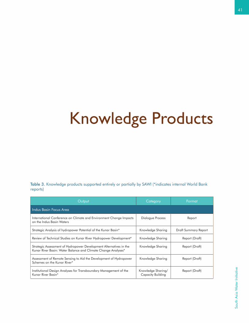
41
Sout
h A
sia
Wat
er In
itiat
ive
Table 3. Knowledge products supported entirely or partially by SAWI (*indicates internal World Bank reports)
Output Category Format
Indus Basin Focus Area
International Conference on Climate and Environment Change Impacts on the Indus Basin Waters
Dialogue Process Report
Strategic Analysis of hydropower Potential of the Kunar Basin* Knowledge Sharing Draft Summary Report
Review of Technical Studies on Kunar River Hydropower Development* Knowledge Sharing Report (Draft)
Strategic Assessment of Hydropower Development Alternatives in the Kunar River Basin: Water Balance and Climate Change Analyses*
Knowledge Sharing Report (Draft)
Assessment of Remote Sensing to Aid the Development of Hydropower Schemes on the Kunar River*
Knowledge Sharing Report (Draft)
Institutional Design Analyses for Transboundary Management of the Kunar River Basin*
Knowledge Sharing/ Capacity Building
Report (Draft)
Knowledge Products

42
Political Economy Assessment of Kunar River Basin Hydropower Development*
Knowledge Sharing Report (Draft)
Understanding and Assessing the Impact of Climate Change in the Indus Basin*
Knowledge Sharing / Dialogue Process
Research Proposal & GIS Mapping Tool (Draft)
Transboundary Water Governance Capacity Building Program* Capacity Building PowerPoints (PPTs) & Training Material
Regional Relevance: The training modules developed for the Afghanistan Transboundary Water Capacity Building Program have wide applicability.
Ganges Basin Focus Area
Water Resource Software: Application Overview and Review Capacity Building Report
Hydro-met Manual Capacity Building Manual
Inception Report: Analytical Work and Technical Assistance to support Strategic Basin Planning for Ganga River Basin in India*
Capacity Building Inception Report
Inception Report: Bihar Flood Management Information System* Capacity Building Inception Report
Visit of the Indian Delegation to The Netherlands and Paris to strengthen the preparation for the National Hydrology Project
Capacity Building Summary Report
Flood Risk Assessment for the Ganges Basin in South Asia Knowledge Sharing/ Capacity Building
Report
Evaluation of Flood Forecasting Predictability Knowledge Sharing/ Capacity Building
Technical Report
Regional Relevance: The report on Water Resources Software has wide applicability and is informing global information products being prepared by the World Bank. The Flood Risk Assessment has regional relevance as the methodology could equally be applied to other basins.
Brahmaputra Basin Focus Area
Role of Institutions in River Basin Management: The Mississippi Experience Informs the Brahmaputra
Capacity Building/ Dialogue Process
Summary Report
Consultation Workshop on Policy Dialogue for Improved Water Governance of Brahmaputra Basin*
Dialogue Process Summary Report
Managing Environmental and Social Impacts of Hydropower in Bhutan Knowledge Sharing / Capacity Building
Report (Draft)
Modernizing Hydro-Met Systems in Bangladesh* Knowledge Sharing / Capacity Building
Technical Notes
Transnational Policy Dialogue for Improved Water Governance of Brahmaputra River: Advisory Committee Board Meeting*
Dialogue Process Briefing Note
Regional Relevance: The study on Environmental and Social Impacts of Hydropower in Bhutan is relevant for all countries seeking to develop hydropower resources. The report provides guidance for identifying environmental and social impacts of planned hydropower projects and a policy framework and institutional requirements to mitigate these impacts. The technical notes on Modernizing Hydro-Met Systems in Bangladesh also have broader regional relevance.
Perf
orm
ance

43
Sout
h A
sia
Wat
er In
itiat
ive
Sundarbans Landscape Focus Area
Sundarbans Joint Landscape Narrative Knowledge Sharing Report (Draft)
Climate Change Adaptation in Coastal Areas & Other Sectors: Experiences from the Sundarbans (India Pavilion, Paris, COP 21)
Dialogue Process Report
Inception Report: Delta Management Investment Planning and Basin Analysis*
Capacity Building Inception Report
Climate Change, Livelihood Threats and Household Responses in the Bangladesh Sundarbans
Knowledge Sharing Report
Impact of Aquatic Salinization on Fish habitats and Poor Communities in a Changing Climate: Evidence from South West Coastal Bangladesh and Sundarbans
Knowledge Sharing Report
Impact of Aquatic Salinization on Mangroves and Poor Communities in the Bangladesh Sundarbans
Knowledge Sharing Report
Bangladesh – India Sundarbans Region Cooperation Initiative Meetings*
Dialogue Process Summary Reports (Draft)
Understanding Transboundary Conservation – Case Studies and Examples
Knowledge Sharing Report
Stakeholder Analysis and Engagement Plan for Sundarban Joint Management Platform
Knowledge Sharing/Dialogue Process
Report
Proceedings of Sundarbans Platform Meeting Dialogue Process Reports
Impact of Climate Change and Aquatic Salinization on Mangrove Species and Poor Communities in the Bangladesh Sundarbans
Knowledge Sharing Report
Species Conservation Indicators for Bangladesh’s Sundarbans region* Knowledge Sharing Report
Nature’s Own People Knowledge Sharing Video Film
Regional Relevance: In the Sundarbans FA, the outputs from all activities provide valuable resources for other basin/region dialogue forums. For example, lessons from the Sundarbans media advocacy group have significantly informed the support to the IWMI Media Dialogues in the Indus River Basin.
Regional Cross-Cutting Focus Area
Water, Ecosystems and Energy in South Asia: Making Cross-Border Collaboration Work
Knowledge Sharing Research Paper
Proceedings of the Regional Flood Early Warning System Workshop Capacity Building Report
International Cooperation and Transboundary Perspectives on Water: TERI India Water Forum, 2016
Dialogue Process Summary Report
Analysis of Water Quality Data from Real Time Water Quality Monitoring Stations (RTWQMS) on River Ganga*
Knowledge Sharing / Capacity Building
Report (Draft)
Existing and Emerging Technologies for Continuous Water Quality Measurement*
Knowledge Sharing / Capacity Building
Report (Draft)
Programmatic Approach to Impact of Climate Change on Water, Hydropower and Dams
Knowledge Sharing Report/Journal Paper
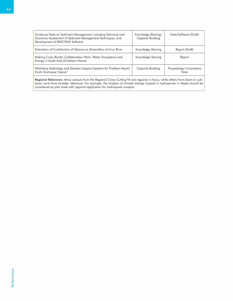
44
Guidance Note on Sediment Management, including Technical and Economic Assessment of Sediment Management Techniques, and Development of RESCON2 Software
Knowledge Sharing/Capacity Building
Note/Software (Draft)
Estimation of Contribution of Glaciers to Streamflow of Arun River Knowledge Sharing Report (Draft)
Making Cross-Border Collaboration Work: Water, Ecosystems and Energy in South Asia (Chatham House)
Knowledge Sharing Report
Workshop Hydrology and Decision Support Systems for Pradhan Mantri Krishi Sinchayee Yojana*
Capacity Building Proceedings/ Innovations Note
Regional Relevance: Many outputs from the Regional Cross-Cutting FA are regional in focus, while others from basin or sub-basin work have broader relevance. For example, the analysis of climate change impacts in hydropower in Nepal should be considered as pilot study with regional application for hydropower projects.
Perf
orm
ance

Appendices

46
Table I-1. Focus Area theories of change and activity descriptions (scope, timeframe, budget allocation and geography); FY16 progress and FY17 work plan details are provided.
Program Management, Strategic Communications and Achieving Results
OverviewActivities have been established to cover: (1) program management; (2) strategic communications; and (3) monitoring and evaluation. The program management activity is seven percent of all contributions and is the management “fee” referred to in the Administrative Agreements. This fee is taken from each contribution payment.
Program Management The MDTF is mapped to the South Asia Regional Vice President’s office, which has the ultimate responsibility for delivery. Trust Fund administration is undertaken by the regional Development Effectiveness unit. On a day-to-day basis, SAWI is managed by a small Secretariat team in the Water Global Practice. The program management activity supports strategic oversight and coordination of SAWI across all Focus Areas and activities, financial management, and annual progress reporting and donor liaison, including the annual donor meeting. Donor liaison includes the governance processes as laid out in the administrative agreements, interactions (especially via an annual forum) with the partner organizations funded by DFAT Australia under their South Asia Sustainable Investment Program, and the annual review process of the DFID South Asia Water Governance Program.
Strategic CommunicationsThis activity supports implementation of the SAWI Communications and Engagement Strategy with a long-term goal to create an enabling environment for cooperation at the basin level. This includes advocacy, awareness building, dissemination and engagement with key stakeholders (government officials, NGOs, academia, civil society groups and the media). The activity works upstream to strengthen positioning at track II events, national and international workshops and conferences, and extends support to FA activities toward the delivery of programmatic results. The activity also supports the maintenance of the SAWI website and knowledge/data portals, and the widely distributed weekly media roundup.
Appendix I – Detailed Activity Descriptions
App
endi
ces
47
Sout
h A
sia
Wat
er In
itiat
ive
Achieving ResultsThis activity supports M&E at the program level and at the FA level. This includes tracking progress in achieving indicator targets at all links of the results chain — activities, outputs, intermediate results and ultimately outcomes. It includes regular reporting, including annual, “mid-term” and closing. For select cases, “result stories” will be prepared that demonstrate impact in terms of tangible results aligned with the program objective. The activity supports communication with donor partners to ensure that information used in their M&E processes is accurate and up to date, and will develop a gender strategy to ensure that gender issues are fully mainstreamed into SAWI activities.
Indus Basin Focus Area
ObjectiveTo improve water resources management and coordination among the riparian countries, Afghanistan, China, India and Pakistan, to enhance water and energy security.
Focus Area Theory of ChangeGiven complex water challenges, high glacier dependency and growing per capita water scarcity, the Indus is the most vulnerable river basin in Asia. The uneasy relationship between riparian countries, different levels of capacity and the presence of a fragile, post-conflict country in the basin pose additional challenges to regional cooperation on water resources management. Given the World Bank’s role in the 1960 Indus Waters Treaty and the importance of neutral engagement, maintaining transparency in World Bank engagement in the Indus River Basin is critical. In response to communications from key riparian stakeholders, investment in this Focus Area is relatively low and focuses on issues not under the purview of the Indus Water Treaty.
Activities focus on tractable efforts where client demand is clear, including: (1) bilateral dialogue and facilitation of institutional development regarding joint hydropower development in the Kabul/Kunar River Basin; (2) identification of the need for and provision of technical assistance at the national level to enhance transboundary (including inter-provincial boundaries) water resources management capacity; (3) support to conjunctive surface water-groundwater management with a focus on Punjab; and (4) continued support to the basin dialogue (commenced in 2013) focusing on development of joint research activities on climate change impact in the Indus River Basin. Pillar 2 will focus primarily on Afghanistan, and also Pakistan, to mitigate for cross-basin differences in country capacity.
Pillar 1 – Long-Term Basin Development and Investment Planning
Punjab Groundwater ManagementScope: Unconfined aquifers in upper and central Punjab in Pakistan bordering neighboring Indian states are contiguous and continuous. Groundwater exploitation across the border may aggravate the already bleak situation particularly when regulatory frameworks to manage the groundwater are absent on both sides of the border. Building on recent groundwater balance assessments, this activity will: (1) sensitize policymakers and provincial water managers to conjunctive surface water-groundwater management; (2) provide technical assistance and capacity building on artificial recharge; (3) undertake various environmental analyses of groundwater systems in the Punjab; and (4) develop a comprehensive action plan to strengthen institutional and legal frameworks.Timeframe: December 2016 – June 2017. Geography: Indus Basin; Pakistan. Budget Allocation: US$0.40 millionFY17 Plan: The activity is subject to internal management approval following fuller articulation and review; it is expected to commence in mid-FY17.
Pillar 2 – Investments and Capacity Building for Water and Energy Security
Integrated Management of the Kunar River BasinScope: This activity aims to improve knowledge of the Kunar River Basin (KRB) resources to both support Bank teams and senior management, as well as guiding the Afghanistan and Pakistan governments, as to the feasibility and best approach to develop the KRB hydropower potential, and thereby contribute to improved long-term energy and water supply security in the region.Timeframe: January 2014 – June 2016. Geography: Indus Basin; Afghanistan, Pakistan. Budget Allocation: US$0.45 millionFY16 Progress: A synthesis report of the five prior technical assessments of potential hydropower cascade development in the basin was completed. The synthesis includes a summary of assessments of technical feasibility under different operational and climate scenarios, institutional and policy considerations, and recommendations for next steps. The synthesis report and assessments will be shared with both governments in FY17.
Kabul/Kunar Basin DevelopmentScope: This activity aims to strengthen capacity within the governments of Afghanistan and Pakistan for establishing institutional frameworks for transboundary waters and infrastructure, and to facilitate dialogue between the two countries to enhance coordination and reach cooperation on the development and management of the KRB/Kabul River Basin.Timeframe: June 2015 – June 2017. Geography: Indus Basin; Afghanistan, Pakistan. Budget Allocation: US$0.60 million

48
FY16 Progress: In response to a request from the Government of Afghanistan, a tailored capacity building program on transboundary water resources management was delivered. The training supported dialogue between different Afghan ministries and prepared officials for high-level transboundary dialogue, including dialogue to advance coordination between Afghanistan and Pakistan on Kabul River Basin/KRB development. The training for 27 officials across nine events covered international water law, notification processes, negotiation, benefit sharing, and data and information sharing in transboundary basins. The training led to the establishment of an inter-ministerial working group on transboundary waters spanning the ministries of Energy and Water, Finance, and Foreign Affairs. If requested, the World Bank will provide similar training for the Government of Pakistan, and/or facilitate high-level bilateral dialogue. This activity has also supported preparation of the restructuring and additional financing (US$70 million) of the World Bank-financed Afghanistan Irrigation Rehabilitation and Development Project, to ensure it comprehensively addresses the needs of the Afghan water sector including an increased focus on river basin management, especially for transboundary rivers. The project will support the newly-established transboundary unit in the Afghanistan Ministry of Energy and Water and the technical secretariat of the Afghanistan Supreme Council of Land and Water, which facilitates a thematic multi-agency government group on transboundary waters.FY17 Plan: Based on the development of relationships between riparian countries in the Indus Basin, the activity will continue to conduct training workshops in transboundary water cooperation and policy development for riparian government officials to strengthen capacity for future dialogue. SAWI stands ready to facilitate dialogue between Afghanistan and Pakistan in the case of a request from both countries.
Pillar 3 – Basin-Level Dialogue
Indus Basin DialogueScope: Since 2013, the World Bank has supported a dialogue for Indus River Basin countries – the Indus Forum – to build confidence and trust in order to establish an enabling environment for basin-wide cooperation. This activity aims to support dialogue in the Indus River Basin, including the Indus Forum, and it focuses on technical collaboration on issues previously identified by the Indus Forum. The activity finances meetings and exposure visits of participants of the Indus Forum. It also aims to facilitate a national dialogue process in Pakistan to implement the recommendations from the 2013 Pakistan Water Summit with key stakeholders to identify specific opportunities for water reform and investment.Timeframe: October 2014 – June 2017. Geography: Indus Basin; all riparians. Budget Allocation: US$0.70 millionFY16 Progress: The IF-WG (constituted at the 3rd Indus Forum meeting, Lahore, March 2015) progressed on a joint research project proposal on climate change impacts on Indus River Basin water resources, focusing on knowledge gaps, education and capacity building. The proposal will be finalized and resources mobilized in early FY17. In FY16, the IF-WG advanced on a baseline assessment of Indus River Basin knowledge on glaciers and climate change. Guided by the IF-WG, young researchers from across the region developed a glacier mapping tool. In February 2016, ICIMOD, IWMI and the World Bank organized an International Conference on Climate and Environment Change Impacts on the Indus Basin Waters with 80 participants. At this conference a joint workshop between the IF and the ICIMOD-facilitated Upper Indus Basin Initiative identified synergies in their current and planned research, and discussed opportunities for improved coordination. (The Upper Indus Basin Initiative is a consortium of research institutions and government agencies engaged in glacier research in the UIB.) At the workshop, it was agreed that the IF would conduct research to influence policy, and would coordinate and integrate projects, programs and research between partners. It was agreed the IF would be expanded by bringing together more regional institutions and development partners, and by bringing together policymakers, researchers and opinion leaders from across the four basin countries. This expansion would create a stronger enabling environment for basin cooperation. The Pakistan Water and Environment Forum (a national off-shoot of World Bank-facilitated dialogues) began preparations for a conference scheduled for October 2016, that will raise awareness of the likely impacts of climate change on the water and environment sectors in Pakistan. Technical assistance under this activity informed the additional financing (US$35 million) for the Pakistan Water Sector Capacity Building and Advisory Services Project that strengthens water resources management in the Indus River Basin of Pakistan, including transboundary management between provinces.FY17 Plan: This activity will continue to support dialogue in the Indus River Basin, including the IF and a Pakistan national dialogue through financing meetings and exposure visits. It will strengthen links up to other track II dialogue processes and research groups, including the Atlantic Council Indo-Pak Dialogue, UIB Initiative and the ICIMOD Himalayan Adaptation, Water and Resilience project, to build confidence and trust among riparian countries. Technical collaboration will focus on issues previously identified by the IF, including: (1) establishment and facilitation of a Technical Working Group for joint work on assessing climate change impact on the Indus River Basin’s cryosphere and hydrology; (2) facilitation of the Pakistan Meteorological Department and China support to enhance capacity at the Afghan Ministry of Energy and Water’s (MEW) Glacier and Permanent Snow Survey Department; and (3) exploration of opportunities to support PhD/Master students and mid-career professionals from riparian countries to train at the Chinese Meteorological Authority and other universities in the Indus River Basin region. Linking to the new Punjab Groundwater Management activity, this activity will facilitate a Pakistan dialogue to implement recommendations from the 2013 Pakistan Water Summit and identify opportunities for water sector reform and investment.
App
endi
ces

49
Sout
h A
sia
Wat
er In
itiat
ive
Ganges Basin Focus Area
ObjectiveTo improve management and development of water resources in the Ganges Basin to support economic growth and improve resilience to climate variability and change.
Focus Area Theory of ChangeCountries in South Asia are unlikely to cooperate for effective basin management if water resources are not well managed nationally. The strategy for the Ganges River Basin focus area is therefore to support improved water resources management nationally and facilitate connections between countries through technical dialogue and capacity building. As well as improving water management nationally for economic stimulation and poverty reduction outcomes, these connected efforts build confidence in transboundary engagement and increase trust around knowledge and information exchange. In India, working to improve data sharing between the center and the states is a necessary precursor to broader public and international transparency.
In India and Nepal, support is being provided to river basin planning. In Nepal, this is via the accelerating development of hydropower (with associated work on watershed management for sediment control); and in India, this is via the drive for river cleanup as well environmental flows for a healthy river, cross-sectoral water allocation and inland navigation. Work under the FA supports the design and implementation of the World Bank-financed NHP in India to improve river basin modeling and river basin planning on a platform of more open data access and sharing.
Operationalizing flood forecasting in the Ganges River Basin at the sub-basin level focuses on activities in the Baghmati sub-basin to build technical competence and improve forecasting skill, as well as to strengthen cross-border cooperation in flood management between Bihar and Nepal. Again this work will guide larger-scale and longer-term efforts in flood forecasting planned under the NHP.
For Bangladesh, as the lower riparian, the major issues remain flooding and access to dry season flows. These issues will be addressed through dialogue facilitated under the Brahmaputra River Basin FA. Active dialogue engagement with key influencers in Bangladesh will help strengthen and focus discussions with upper riparians on river basin planning, inland navigation and hydropower benefit sharing. Total investment in the FA has increased in response to the significant government interest in the Basin, including for sustainable hydropower development in Nepal and for river rejuvenation and inland navigation in India. While the work under Pillar 1 will contribute significantly to the environmental aspects of water management in India and Nepal, the work is designated as “river basin planning” given the increasing interest in all countries to adopting a basin approach to water management.
Pillar 1 – Valuing the Environment and Ecosystem Services
Strategic Basin Planning for the Ganges in IndiaScope: This activity is providing technical assistance to the Government of India and basin state governments in scenario-based river basin modeling and participatory river basin planning for the Ganges River Basin in India. The activity aims to develop a comprehensive basin model for the Ganges in India that enables objective assessment of the likely effectiveness of different options for improving river health and the impacts these options have on the ability to meet consumptive water demands and support inland waterway navigation. The activity is being implemented via a major contract for work on basin-scale modeling, surface water-groundwater interactions, environmental flows, stakeholder consultation, and basin information systems. The work is proceeding well in close cooperation with the Indian Ministry for Water Resources, River Development and Ganga Rejuvenation, and relevant state government agencies. The activity is highly relevant to the NHP that is under preparation and is seen by the Government of India as a pilot for the multiple river basin modeling and planning activities to be advanced under this project. It will also help inform the NGMIP. The activity is also relevant to the National Ganga River Basin Project and the Uttar Pradesh Water Sector Restructuring Project.Timeframe: November 2014 – June 2017. Geography: Ganges Basin; India. Budget Allocation: US$4 millionFY16 Progress: Procurement was concluded for a major contract for the technical assistance and analytical work. A project office was established in New Delhi (hosted by the client ministry) with permanent international staff and regular visits of senior specialists assigned to the project. Early focus has rightly been on relationship building, stakeholder consultation and data discovery. A project inception report detailing the full project plan and methods was prepared. A series of consultation workshops were conducted, including a basin-wide workshop for central and state agencies, and consultation workshops in each of the eleven basin states. These workshops increased awareness of the activity and its objectives, highlighted stakeholder perceptions and concerns, and built a broad-based and ongoing consultation process to guide scenario modeling. The concept of basin planning is now well understood and accepted as best practice among the targeted agencies. This is a high-profile activity for the Government of India and is acting as a pilot study for the river basin planning to be conducted across all major river basins in India under NHP. It is influencing government policy discussions on basin planning and water resources management reform nationwide.

50
FY17 Plan: The project team will develop a comprehensive modeling suite for the Ganges Basin in India encompassing watershed, river and groundwater hydrology and water resources management. The modeling suite will be used to objectively assess the likely effectiveness of different options for improving river health and the impacts these options have on the ability to meet consumptive water demands and support inland navigation. This will be conducted in close consultation with the key stakeholder groups that have been established. Additionally in FY17, a basin-wide environmental flow assessment will be conducted, building on prior work; this will be conducted in partnership with central and state government officers to build an understanding of, and capacity in, environmental flows assessments. The project will continue to promote processes and mechanisms for transparent sharing of data and information, including through the development of a modeling dashboard for web access to model outputs.
Sustainable Water Resources Development for Hydropower in Nepal (RE)Scope: This recipient-executed activity aims to strengthen the capacity of the Nepalese power sector to plan and prepare hydropower and transmission line projects according to international standards and best practices that take account of basin-wide water resource management issues, and to improve the readiness of the power and water sector for regulatory and institutional reforms. This activity is linked to the Power Sector Reform and Sustainable Hydropower Development Project.Executing Agency: Water and Energy Commission Secretariat (WECS) in the Ministry of Irrigation, NepalTimeframe: June 2016 – June 2017. Geography: Ganges Basin; Nepal. Budget Allocation: US$2.50 millionFY16 Progress: The Nepal Electricity Authority (NEA) and the WECS Secretariat established the project management unit and commenced procurement for river basin planning across the major river basins of Nepal.FY17 Plan: Procurement of a consulting firm to undertake river basin planning work in partnership with WECS will be concluded. River basin plans will be developed for the Kosi, Gandaki, Karnali and West Sapti basins. A publically accessible information repository will be developed that will include river basin Geographic Information System (GIS) files, a basin atlas, and other relevant databases including meteorology, hydrology, topography, geology, land use, water use, water demand, as well as existing and potential water sector projects, hydropower projects, water supply projects, irrigation projects, and other relevant schemes. A review of existing data, plans, policies, and institutional arrangements will be conducted.
Sustainable Water Resources Development for Hydropower in Nepal (BE)Scope: This activity will enable the World Bank to provide implementation support to the above recipient-executed activity. This activity aims to enhance the Government of Nepal’s (GoN) water resources management and development capacity by: (1) increasing awareness of river basin planning as a mechanism to guide environmentally, sustainable development hydropower balanced with water resource uses; (2) facilitating institutional and regulatory reform in the water resources sector; and (3) building capacity in environmental and social safeguards. By strengthening capacity in the GoN and supporting river basin planning and improved water management, the activity will enable the GoN to engage in a more informed and more confident way with downstream riparian countries in future transboundary discussions and negotiations.Timeframe: June 2016 – June 2017. Geography: Ganges Basin; Nepal. Budget Allocation: US$1.70 millionFY16 Progress: Preliminary work focused on consensus building, government approvals, procurement and donor collaboration. Consultations were held with government agencies, development partners, private hydropower developers, the Nepal Federation of Business and Industry Association, local academic and research institutions, and communities groups in the project areas. Agreement was reached with local and international universities on the design of a national water resources capacity building program. By the end of FY16, procurement had commenced for review and amendment of the Nepal Water Resources Act, for revision of environmental regulations, and for environmental flow studies.FY17 Plan: Preliminary work will focus on consensus building, government approvals, procurement and donor collaboration. The activity will also carry out education activities, including student and faculty exchange programs and technical assistance on curriculum development.
Managing Watersheds to Reduce Upstream Sediment for HydropowerScope: This activity is identifying and prioritizing investments in upstream catchments to reduce sediment inflow to the Kali Gandaki A hydropower plant in Nepal. It is also building capacity within the NEA and other relevant departments to apply tools and processes for improved watershed management; and facilitate knowledge exchange and dissemination of upstream sediment management approaches to other countries.Timeframe: July 2015 – November 2016. Geography: Ganges Basin; Nepal. Budget Allocation: US$0.20 millionFY16 Progress: A literature review was completed on the processes and management of sedimentation, and a synthesis was prepared on the relevant legislation, policies, guidelines, and institutions in Nepal to inform the catchment investment plan. The first phase of catchment modeling was completed and preliminary results were obtained from the RIOS and SWAT models to inform the catchment investment plan. These preliminary results were presented to stakeholders in March 2016. The NEA, WECS, the Department of Soil Conservation and Watershed Management and others, provided feedback on improving the country-relevance of the modeling and on improving the outputs in the second phase. The modeling work was updated accordingly. During the consultation participants were introduced to the modeling approaches for catchment sediment sourcing (SWAT) and ecosystem impacts (RIOS).
App
endi
ces

51
Sout
h A
sia
Wat
er In
itiat
ive
FY17 Plan: The activity is well advanced and will conclude in the first quarter of FY17. Final results of a synthesis on the relevant legislation, policies, guidelines and institutions in Nepal to inform the catchment investment plan, catchment modeling and preliminary results from the RIOS and SWAT models (obtained to inform the catchment investment plan) will be disseminated in Nepal and Washington DC.
Pillar 2 – Moving from Data to Information Services
Water Resources Management in Transboundary BasinsScope: This activity provides support to the preparation of the World Bank-financed NHP by facilitating access to international best practice to inform project design—especially relating to river basin planning and management in transboundary basins. NHP focuses on the use of water data in planning and management, including via modeling in support of basin planning and basin water resources assessments, flood management and reservoir operations.Timeframe: November 2014 – June 2017. Geography: Ganges and Brahmaputra basins; all riparians. Budget Allocation: US$0.50 millionFY16 Progress: Six training workshops on hydro-meteorological instrumentation and IWRM modeling tools were conducted for about 250 participants from state and central government agencies. Consultation meetings were held with state officials from the Ganges and Brahmaputra Basins, including from Assam, Nagaland, Meghalaya, Manipur, Sikkim, West Bengal, Bihar, Uttar Pradesh and Uttarakhand. Discussions focused on hydro-meteorological network design and identification of specific basin development and management issues. A consultation workshop on Supervisory Control and Data Acquisition (SCADA) design and implementation was held for officials from the Ganges Basin (from Rajasthan, Uttar Pradesh and West Bengal). A manual and training materials for hydro-meteorological instrumentation were prepared and shared publically at www.indiawrm.org. Concepts were developed and discussed for a national water information center and a northeast regional water information center, both to be supported under NHP. A comprehensive review of water resource management software was prepared and shared widely; it has been adopted by several Indian water agencies to guide model selection for flood management, sedimentation and basin planning. Consultative meetings with central government on data sharing and open access data led to development of a data sharing policy for the project that will enhance the accessibility and utility of water resources data in India. A framework agreement on technical specifications for hydro-meteorological instruments was drafted.FY17 Plan: An IWRM model with online capability will be developed for one of the sub-basins of the Ganges and will be used to showcase collaborative modeling among various riparians (multiple Indian States and Bangladesh). Exchange visits and workshops will be organized for the riparians to showcase integrated approaches to river basin planning including connected surface and groundwater resources. An international hydro-met workshop will be organized to expose riparian countries to the importance of and technologies for transparency in sharing river basin information.
Strengthening Flood Management Information System (FMIS) Capacity in Bihar (RE)Scope: This recipient-executed technical activity builds on the outcomes of the regional scoping study on flood forecasting to strengthen institutional capacity in the Government of Bihar, India, and to improve community outreach for flood management in the Baghmati-Adhwara Basin (a transboundary sub-basin of the Ganges River Basin spanning Nepal and India).Executing Agency: Government of Bihar, IndiaTimeframe: January 2016 – June 2017. Geography: Ganges Basin; India. Budget Allocation: US$0.50 millionFY16 Progress: A two-day inception workshop in Patna, in February 2016, allowed international and national experts to share best practices in flood modeling with government officials. Engineers from the Flood Management Information System Cell of the Bihar Water Resources Department were trained to be able to independently run the existing flood risk model. Additionally, terms of references for key sub-activities were finalized, and work is now under way to customize a meteorological framework for ensemble rainfall estimates and forecasts, improve community outreach for flood risk management and institutionalize modeling capacity.FY17 Plan: Consultancies will be established for: (1) flood modeling using public domain license-free software; and (2) development of a customized meteorological framework for ensemble rainfall estimates and forecasts. In addition, work will commence on improving community outreach for flood risk management. Institutionalizing modeling capacity will occur through training in flood models, customized meteorological framework and community outreach, including preparation of training and operational manuals.
Bihar FMIS Flood ForecastingScope: This activity enables the World Bank to provide focused support to the Government of Bihar in their implementation of the recipient-executed activity (above). The activity aims to improve flood forecasting capability of the Government of Bihar by supporting travel of government officials to flood modeling centers of excellence, and supporting visits to Bihar by experts and consultants to improve the existing flood risk model.Timeframe: September 2015 – June 2017. Geography: Ganges Basin; India. Budget Allocation: US$0.50 million

52
FY16 Progress: The existing model was updated with the latest river cross-section data and with data from 17 real-time rainfall stations in Nepal and 23 rainfall stations in Bihar. The model was calibrated for 2013-14 using observed water levels (discharge data is not available). A network of six real-time gauge stations across the basin is being established for stage and discharge data and for the development of rating curves to support improvement and extension of the flood model for the entire basin. Through the World Bank-financed Kosi Basin Development Project in Bihar, this activity will help scale up the flood model for wider transboundary coverage.FY17 Plan: A customized meteorological framework will be developed, supported by experts from the US National Centre for Atmospheric Research. The existing flood forecasting model will be extended to cover the entire basin to its confluence with the Kosi using discharge data and a two-dimensional flood inundation model to analyze embankment breach scenarios. The activity will also support official visits to centers of excellence for training, and develop flood data dissemination dashboards for implementation under the recipient-executed activity.
Pillar 3 – Basin-Level Dialogue
Ganges Basin DialogueScope: Building on the national level technical assistance in river basin modeling and planning in both India and Nepal, this activity supports basin-wide dialogue on hydrologic and water resources modeling. The activity connects technical institutions in the region with scientists and academics around the world that are actively engaged in modeling the Ganges River Basin.Timeframe: October 2014 – June 2017. Geography: Ganges Basin; all riparians. Budget Allocation: US$0.40 millionFY16 Progress: Under this activity a basin modeling Community of Practice (CoP) was previously established. The activity supported the participation of two academics in The Energy and Resources Institute (TERI), India Water Forum, in April 2016. As the Ganges Strategic Basin Planning activity gains momentum, it will be used as a point of engagement for the broader basin dialogue process, to bring in participants from Nepal and Bangladesh, together with international experts.FY17 Plan: This activity will support national and Basin-wide dialogue linked to the country-level technical Ganges activities. There will be a strong emphasis on river basin planning and on cooperative opportunities in hydropower and inland navigation. Opportunities will be actively sought to informally engage at technical and policy levels in all countries on these and other relevant issues. The nascent Ganges Basin Modeling CoP will become more active, linking to the substantive work in support of basin planning in both India and Nepal.
Brahmaputra Basin Focus Area
ObjectiveTo improve the shared understanding and management of the Brahmaputra Basin as a means to strengthen resilience and economic growth for the riparian countries.
Focus Area Theory of ChangeActivities under the Brahmaputra River Basin FA focus on addressing water-related challenges (flooding and riverbank erosion) and assessing economic opportunities, including from hydropower and inland navigation. Knowledge exchange activities, study tours and workshops, and assessments, conducted to support these issues, will not only demonstrate economic benefits from cooperative management but will provide a platform for riparian countries to come together and build the case for regional cooperation.
Pillar 1 activities will develop a shared knowledge base for the entire Brahmaputra River Basin to support investment planning and decision-making. This will include relevant assessments and modeling, decision support tools to assist policymakers in making informed, analysis-driven decisions, and capacity building activities within relevant agencies to operationalize these tools and make strategic, informed decisions. The knowledge base will support basin-wide river management, investment planning at a national and/or basin level, adaptive management in deltaic regions, flood and sediment management, and exploring cross-sector opportunities such as hydropower and navigation.
Pillar 2 activities focus on reducing community vulnerability to water and climate-related risks and building community resilience. An adaptive management framework is used to strengthen riparian countries’ capacity to respond and adapt to changes in the basin. Activities include: (1) improvements in existing infrastructure and instruments, including early warning systems, flood embankments and other hydraulic infrastructure; (2) improving the understanding of river morphology and erosion trends vis-a-vis development of a basin-wide and/or nation-wide sediment accounting model; and (3) capacity building, training and knowledge exchange activities, particularly focused on flood and erosion management.
Pillar 3 provides a platform for riparian countries to discuss challenges and identify opportunities for collaboration through study tours, workshops and conferences. The overarching aim is to improve cooperation through increasing opportunities to engage and discuss common challenges.
App
endi
ces

53
Sout
h A
sia
Wat
er In
itiat
ive
Pillar 1 – Knowledge and Capacity Building for Basin Management and Investment Planning
Basin Modeling and AnalysisScope: This activity will undertake a strategic assessment of the Brahmaputra River Basin in India to gain a better understanding of the basin dynamics of the river basin. It will develop a comprehensive basin-wide knowledge base and model suite for assessment of water resources considering climate change, basin-scale development pressures, and alternative investment scenarios. Targeted studies on erosion and the role of embankment failures in floods and inundations will be commissioned. The activity will include multi-stakeholder consultations and capacity building for central and state agencies. The activity links closely with the World Bank-financed NHP, which will apply lessons learned to river basin planning across India. The activity also links closely with the Assam Flood, Erosion and River Management Modernization Project (US$250 million)Timeframe: March 2016 – June 2017. Geography: Brahmaputra Basin; India. Budget Allocation: US$1.20 millionFY16 Progress: Procurement commenced for work to develop a comprehensive knowledge base and a suite of modeling tools to examine potential development in the basin, including under climate change, as well as to conduct studies of erosion and embankment failure. This test case in river basin planning will inform the World Bank-financed NHP, which will support river basin planning across India. It will also inform the Bangladesh Basin Analysis (below) and the Brahmaputra Dialogue (below).FY17 Plan: The procurement of the firm to conduct the work will be completed in early FY17 and activities will commence immediately, including the establishment of a field office in India (likely Assam). By the end of the FY, it is expected that a first draft of all reports on Strategic Basin Planning and targeted studies will be completed.
Delta Management Investment Planning and Basin AnalysisScope: This activity is supporting the Government of Bangladesh in the preparation of the investment plan for BDP 2100 – a long-term holistic and integrated plan for the Bangladesh Delta. BDP 2100 will prioritize a sequence of investments for the coming fifteen years, supported by policy and regulatory reforms and institutional capacity building, and based on the principles of adaptive delta management. The activity will build on the State of the Basin Assessment to identify interventions or capacity building areas that assist in investment planning. The work will explore a range of issues, including the climate change impacts; options analysis for investment planning; impacts from development scenarios including hydropower development and interventions to improve irrigation productivity; and recommendations for improving basin-wide water management. The activity is a key part of a larger analytical study that will provide multi-sectoral solutions to delta management in Bangladesh. It helps make operative the MoU signed by the governments of Bangladesh and the Netherlands, together with the World Bank, to advance Adaptive Delta Management in Bangladesh in the context of basin-wide planning and management, and is co-financed by an activity under the Sundarbans FA (see below).Timeframe: September 2015 – February 2017. Geography: Brahmaputra Basin; Bangladesh. Budget Allocation: US$0.80 millionFY16 Progress: Procurement for preparation of the investment plan was completed, following two missions that defined milestones, a work plan and a methodology for preparation of the investment plan. Major contracts were awarded to Castalia (Strategic Advisors, New Zealand) and Riverside Technologies (USA). Castalia’s inception report and proposed methodology were shared and agreed with line ministries and other stakeholders at a roundtable meeting in April 2016. The activity is co-financed with an activity under the Sundarbans FA (below).FY17 Plan: Specific work includes: (1) completion of a basin-wide information database; (2) finalization of a decision support platform for the Brahmaputra River Basin in Bangladesh; and (3) additional workshops and knowledge exchange activities to enhance technical and institutional capacity.
Environmental and Social Management for Sustainable HydropowerScope: In response to a request from the Government of Bhutan, this activity was established to improve the environmental and social planning and management of hydropower in Bhutan.Timeframe: July 1, 2015 – June 30, 2016. Geography: Brahmaputra Basin; Bhutan. Budget Allocation: US$0.20 millionFY16 Progress: A gap analysis was undertaken, including a nationwide assessment of the potential environmental and social impacts of hydropower, analysis of existing policies, guidelines and practices, and assessment of one hydropower project using the Hydropower Sustainability Assessment Protocol. The study informed a two-day discussion on Bhutan’s capacity to further develop hydropower in the 16th Session of the National Council (the Lower Chamber) of the Government of Bhutan. Recommendations from the study — including the need for targeted work on cumulative impacts and improvement of the guidelines for preparation and implementation of hydropower — were shared at a workshop in April 2016 with more than 50 government participants. A training workshop on international good practice for hydropower, social and environmental impact analysis, and management was held in February 2016. The work has informed the drafting of the new National Hydropower Policy and has strengthened Bhutan’s National Environmental Commission by increasing awareness and skills on basin-scale planning for hydropower, including cumulative impacts. As a result of the World Bank support, the government has decided to initiate planning studies on hydropower development, including a study on cumulative impacts, and has decided to establish national guidelines for preparing and constructing sustainable hydropower. Collectively, these will inform a strategic roadmap for national hydropower development.

54
Bhutan Hydropower Environmental and Social PlanningScope: In response to a request from the Government of Bhutan, this activity builds on the SAWI-supported activity Environmental and Social Management for Sustainable Hydropower, which was completed in FY16. The activity will improve the environmental and social planning and management of hydropower in Bhutan, including developing guidelines for basin planning and cumulative impact assessments.Timeframe: July 2016 – June 2017. Geography: Brahmaputra Basin: Bhutan. Budget Allocation: US$0.30 millionFY17 Plan: Work will focus on commencing the development of improved environmental and social guidelines, analytical studies and capacity building for environmental flow assessments and cumulative impact assessments.
Pillar 2 – Reducing Vulnerability to Floods and Erosion
River Management Improvement: BangladeshScope: The River Management Improvement Project (RMIP) in Bangladesh (US$650 million) will support on-ground investments and operations dealing with flood mitigation infrastructure to reduce the impacts of erosion and channel migration. The RMIP investment plans are expected to shape the future Brahmaputra River Basin in Bangladesh. This activity funds technical work and broader consultation to inform the investment planning and to ensure international lessons learned as well as basin-wide aspects are taken into consideration. It complements the separately financed project preparation work to enable a basin-scale perspective to guide the project design and to ensure transboundary impacts and opportunities are identified.Timeframe: May 2015 – September 2016. Geography: Brahmaputra Basin: Bangladesh. Budget Allocation: US$0.35 millionFY16 Progress: A report was developed on the use of dredging for improved navigability and river training to reduce flood and erosion risks, considering basin-wide erosion and sedimentation processes. Cumulative impact assessments, plans for an embankment asset management system, and a technical note on dredging and river management and cost-effective technologies, were prepared in the reporting period to inform project design. The activity enabled a basin-scale perspective to guide project design and to ensure that transboundary impacts and opportunities are adequately taken into account.FY17 Plan: Given delays in the approval of RMIP, a short extension to this activity was approved to allow the opportunity to support any required final technical support or analysis.
Hydro-met Modernization in the Brahmaputra BasinScope: This activity is strengthening institutions, facilitating knowledge exchange and enhancing cooperation in the management of hydro-meteorological risks within the South Asian countries. The activity undertakes analytic work and provides technical assistance to strengthen the capacity of key institutions in the Brahmaputra River Basin countries to respond to cross-border water related hazards and climate risks. The activity has developed a roadmap to modernize hydro-meteorological monitoring, to improve the accuracy and lead time for weather and flood forecasting, and to enhance community-based early warning systems. The activity is part of a broader World Bank South Asia Regional Hydro-met Program building national and regional capacity for disaster risk management and weather - and climate based - services.Timeframe: December 2014 – December 2016. Geography: Brahmaputra Basin: Bangladesh, Bhutan. Budget Allocation: US$0.25 millionFY16 Progress: A detailed analysis of Bhutan’s existing hydro-met monitoring network, forecasting and early warning systems was completed, and the final report was published and disseminated. The work informed the design of the World Bank-financed Hydro-met Services and Disaster Improvement Regional Project. Technical notes on modernizing hydro-met systems in Bangladesh were prepared, leading to an improved design of the recently approved World Bank-financed US$113 million Bangladesh Weather and Climate Services Regional Project. An economic analysis of hydro-met modernization in Bangladesh commenced.FY17 Plan: Although the substantive work of this activity is complete, an activity extension to the end of 2016 was approved to enable quality completion of the economic analysis of hydro-met modernization.
Bhutan Hydro-met Services and Disaster Improvement (RE)Scope: This recipient-executed activity builds on the Hydro-met Modernization in the Brahmaputra Basin activity to strengthen Bhutan's capacity for hydro-met services and disaster preparedness through: (1) strengthening the capacity of Bhutan’s Department of Hydro-met Services to improve hydro-met monitoring, forecasting and service delivery to priority sectors; (2) strengthening capacity for disaster preparedness and response (working through the Department of Disaster Management); and (3) funding the design of an agro-met decision support system, development and delivery of agro-met information products in two administrative and judicial districts, training, and capacity building (working through the Department of Agriculture). This is a US$3.30 million activity co-financed by the Global Facility for Disaster Risk Reduction and Recovery.Executing Agency: Royal Government of BhutanTimeframe: July 2016 – June 2017. Geography: Brahmaputra Basin: Bhutan. Budget Allocation: US$0.50 millionFY17 Plan: The one-year activity will fund improvements in monitoring, forecasting, ICT, hardware, and software to improve government services. It will also support training for capacity strengthening, and fund a consultancy to prepare bidding packages, and strengthen project management and M&E activities. It will fund design of an agromet decision support system, and development and delivery of agromet information products in two districts.
App
endi
ces

55
Sout
h A
sia
Wat
er In
itiat
ive
Pillar 3 – Basin-Level Dialogue
Brahmaputra Basin DialogueScope: This activity is increasing regional cooperation by providing a platform to discuss shared water challenges and opportunities. It is enhancing trust and working relationships between basin riparian countries to foment consideration of river basin management of the Brahmaputra River Basin, considering country-specific needs and priorities. The activity will support national and basin-level meetings as well as capacity building events, dialogue events, workshops, roundtables, and study tours to facilitate the exchange amongst stakeholders of ideas, viewpoints, knowledge and development plans for the Brahmaputra River Basin.Timeframe: January 2015 – June 2017. Geography: Brahmaputra Basin: all riparians. Budget Allocation: US$0.70 millionFY16 Progress: The activity continued to support its Brahmaputra Dialogue forum of policymakers, academics and opinion leaders from Bangladesh, Bhutan, China and India. In support of the dialogue process, a review of transboundary protocols and accords and an institutional mapping were undertaken. Several track II meetings and workshops among Brahmaputra River Basin riparians were facilitated and an informal Advisory Committee of technocrats from the participating countries was established to guide the dialogue process. National workshops were convened in Bangladesh and China to discuss economic development, disaster management and knowledge sharing. A study tour to the Mississippi River, USA, was conducted in November 2015 for a high-level delegation from the Ministry of Water Resources, Bangladesh, and the Ministry of Economic Affairs, Bhutan. The delegation learned about the role of strong institutions in managing the Mississippi River. The study tours and dialogue forum provide neutral platforms identifying opportunities for basin-wide cooperation.FY17 Plan: The first round of national level workshops will be completed, with consultations held in India (August 2016) and Bhutan (September 2016). The first regional level workshop is planned for Singapore in October 2016, with high-level representation from all four riparian countries. A second round of national level workshops commencing in the second half of FY17 will follow. A detailed institutional mapping will be developed to near-completion. To support the dialogue process, a study tour to the Yellow River Basin is planned for late FY17.
Sundarbans Landscape Focus Area
ObjectiveTo operationalize joint management of the Sundarbans for sustainable development that delivers mutual benefits for the two countries.
Focus Area Theory of ChangeThe challenges of the Sundarbans (extreme poverty, frequent natural disasters and erosion of ecosystem services) would be better managed if Bangladesh and India developed and implemented a joint conservation and development policy, and increased collaboration on plans and programs. To date, the formal dialogue and collaboration between the two countries has been inadequate. While non-binding bilateral agreements were signed in late 2011 outlining a framework for collaboration on international waters, information sharing, disaster management and climate change, these are yet to be implemented. The Sundarbans FA directly supports implementation of these agreements and country actions based on a landscape perspective.
FA support includes developing a stronger analytical basis to help governments move towards integrated planning and management. Bilateral dialogue, research, and information exchange will support the analytical work and will build technical capacity, thus enhancing cooperation. A landscape-level planning and management framework and supporting institutions are required for collaborative management. Technical analyses will be complemented by: (1) advocacy work to generate public support for cooperation; (2) establishment of governance arrangements for joint planning; and (3) substantive joint actions (e.g. shared plans and policies) for conservation and sustainable development.
Given that broad agreement for collaboration exists, activities under the FA are demand-driven. Initial activities were informed by stakeholder consultation. Establishing a more formal mechanism for collaboration will guide future activity choices, and multi-stakeholder dialogue will guide all joint studies and joint planning work.
Pillar 1 – Enhancing Bilateral Cooperation
Landscape-scale Joint Environmental PlanScope: This activity aims to help Bangladesh and India establish appropriate information (collection, collation and dissemination) systems to support preparation and implementation of plans for the development and conservation of the Sundarbans. Timeframe: April 2016 – June 2017. Geography: Sundarbans; Bangladesh, India. Budget Allocation: US$0.30 millionFY16 Progress: This activity supported the development of the first joint landscape narrative for the Sundarbans by experts and authors from Bangladesh and India, combining existing single-country narratives. Drafts were shared with academics for review. Analytical work on coastal and estuarine fisheries in the Sundarbans commenced. The development of a conceptual framework for Sundarbans fishery resource assessments led to a request from the Government of Bangladesh for a US$168 million World Bank-financed Sustainable Fisheries Project.

56
FY17 Plan: Implementation has been delayed but will accelerate to deliver a combined geomorphic Sundarbans narrative and multi-stakeholder discussions on the draft narrative. Additionally, three-to-five potential joint actions for institutions in Bangladesh and India will be identified and the work on coastal and estuarine fisheries in the Sundarbans that began in FY16 will be completed.
Sundarbans DialogueScope: This activity aims to build trust and working relationships between India and Bangladesh to further sustainable management of the Sundarbans based on country-specific needs and landscape-level priorities. The dialogue process (through identification and implementation of specific cooperative activities) aims to create Sundarbans management ownership among government and non-government agencies and to facilitate the operationalization of the MoU on Sundarbans Cooperation signed between the two countries in 2011. WWF, International Water Association (IWA) and the Observer Research Foundation are key partners in delivering this activity.Timeframe: April 15, 2015 – June 2017. Geography: Sundarbans; Bangladesh, India. Budget Allocation: US$1 millionFY16 Progress: The BISRCI was conceptualized, facilitated, established and financed. BIRSCI is a multi-stakeholder dialogue process of policy think tanks, civil society organizations and academic institutions. Initial dialogues have discussed options and ways forward for actualizing the concepts of cooperation, collaboration and joint management of the landscape; and found significant traction at the highest policymaking levels in both Bangladesh and India. This was further demonstrated by the high level in the joint India-Bangladesh side event on Sundarbans Landscape at the Paris COP 21 in December 2015 that was supported under this activity. In the last year, an additional dialogue process was established for print and electronic media from both countries and workshops, which led to a draft media collaboration plan. An international workshop on resilience for delta regions was supported, exposing India participants to the BDP 2100 processes, and three Bangladesh-India meetings on landscape cooperation were convened with participation of officials from both countries. In two sessions of the West Bengal State Assembly, landscape development issues and cooperation with Bangladesh were discussed with expert contributions from the World Bank and partners.FY17 Plan: Joint events between the Bangladesh and India environment ministries on identification of priorities and pathways for Sundarbans cooperation are scheduled for November and December 2016. International workshops will be conducted on inland water transport (with a focus on Bangladesh-India transboundary routes; December 2016) and eco-tourism (June 2017). A GIS map of routes for general tourism and eco-tourism for target groups in West Bengal and Bangladesh will be prepared; and two knowledge products: (i) Joint Landscape Narrative on Sundarbans and (ii) Economic Costs of Non-Cooperation on Sundarbans, and five “Joint Activity Proposals”, will be published. The activity will also facilitate media collaboration activities between media houses in both Bangladesh and India to support operationalization of the MoU.
Pillar 2 – Technical Cooperation to Support Joint Management
Landscape Hydro-met DesignScope: This activity supports design of a hydro-met system for the Sundarbans that would include climate stations, tide gauges, wave rider buoys and water quality monitoring. It will develop a strategy for establishing and operating hydro-met and local weather forecasting systems, and analyze bathymetry, salinity intrusion and conservation needs of the freshwater resources.Timeframe: July 2015 – June 2017. Geography: Sundarbans; Bangladesh, India. Budget Allocation: US$0.40 millionFY16 Progress: Three reports were drafted defining geomorphic boundaries for the Sundarbans, assessing the current state of hydro-met infrastructure, and identifying gaps in the hydro-met system. Given uncertainties in the data underlying these analyses a rigorous independent review of these reports is planned for FY17 prior to finalization and dissemination to inform stakeholder dialogue.FY17 Plan: Implementation was delayed in FY16, but will accelerate to deliver a draft plan for establishing harmonious coastal and near-shore hydro-met systems, and a study of salinity intrusion from estuaries and rivers to groundwater and thence to the soil surface that recommends mitigation measures. In addition, inputs will be provided to the World Bank-financed NHP and the World Bank-financed Bangladesh Weather and Climate Services Regional Project.
Targeted Environmental StudiesScope: This activity is undertaking hydrological, ecological and econometric studies for vulnerability assessment of the Sundarbans ecosystem in a changing climate. This activity will enhance awareness about climate change risks, promote technical cooperation, build the knowledge base to support joint management, and facilitate planning a holistic approach to the sustainable management of this extremely fragile mangrove forest.Timeframe: April 2015 – June 2017. Geography: Sundarbans: Bangladesh, India. Budget Allocation: US$0.80 millionFY16 Progress: This activity supported four environmental studies: (1) Climate Change, Livelihood Threats and Household Responses in the Bangladesh Sundarbans; (2) Impact of Climate Change and Aquatic Salinization on Fish Habitats and Poor Communities in Southwest Coastal Bangladesh and Bangladesh Sundarbans; (3) The Impact of Climate Change and Aquatic Salinization on Mangrove Species and Poor Communities in the Bangladesh Sundarbans; and (4) Species Conservation Indicators for Bangladesh’s Sundarbans Region. The methodologies and main findings have been shared with researchers in India to guide ongoing collaborative environmental studies of the Sundarbans.
App
endi
ces

57
Sout
h A
sia
Wat
er In
itiat
ive
FY17 Plan: The environmental studies will be peer-reviewed and finalized, and then disseminated. In addition, preparation of two geo-coded databases and three reports on flora and fauna threatened by climate change will be completed.
Delta Management Investment PlanningThis activity is co-financed under the Brahmaputra River Basin FA and is described earlier.
Regional Cross-Cutting Focus Area
ObjectiveTo build knowledge and capacity across the region in support of transboundary basin dialogue and cooperation.
Focus Area Theory of ChangeThe Regional Cross-Cutting FA will improve the quality and accessibility of regional water resources data sets and building water resources knowledge, undertake capacity building for shared water resources management and cooperation, and support broad-based regional dialogue to enhance cooperation and management of transboundary waters in South Asia.
Pillar 1 – Knowledge Related Activities
Climate Change Impacts on HydropowerScope: This activity supported trialing in South Asia various methods for screening climate change and disaster risks, and for integrating resilience measures into hydropower projects.Timeframe: September 2014 – December 2015. Geography: Regional; Nepal focus. Budget Allocation: US$0.35 millionFY16 Progress: A “decision tree” model was applied at the project level for Upper Arun hydropower project in eastern Nepal and at the basin level for hydropower development across the entire Kosi Basin. The decision tree model was developed by the World Bank to assist project planners to adopt a decision making under uncertainty approach to the assessment and management of climate change risks. The analysis for Upper Arun identified design changes required to “climate proof” the investment, and provided proof of concept for planning and design for climate-resilient water resources infrastructure. The analysis for the Kosi Basin tested efficient and robust mixes of planned hydropower capacity, laying the groundwork for future river basin and energy sector planning. Sediment effects were included in the analysis and a technical note on sediment management (including a technical and economic assessment of sediment management techniques) was prepared and shared. RESCON2 – which guides development of strategies for sustainable reservoir storage management – was updated and released. The decision tree analysis was presented to the International Commission on Large Dams in Switzerland (October 2015) and to the International Hydropower Association in the United Kingdom (November 2015). The technical note of sediment management and the RESCON2 update were presented at various hydropower conferences during the year. This work was part of a broader World Bank initiative on “Understanding the Impacts of Climate Change and Other Risks on Hydropower in the Himalayas”. A synthesis report for this initiative has been completed and parts will be published in the International Journal of Hydropower and Dams.
Snow/Glacier Contributions to Streamflows and Climate Change ImpactsScope: This activity aimed to establish a methodology and develop quantitative estimates of the contribution of snow and glaciers to river flow in selected basins/sub-basins across the Himalayas, and to assess how these contributions will be affected under climate change scenarios. Such information is necessary to assess the resilience of water resource infrastructure, e.g. the performance of reservoir storage and run-of-river projects, reliability of water supply for irrigation, municipal and industrial uses; as well as impacts on the environment.Timeframe: October 2014 – December 2015. Geography: Regional; Nepal focus. Budget Allocation: US$0.15 millionFY16 Progress: This activity developed and applied a novel method to quantify the contributions of snow and glaciers to river flows under current and future climate. The case study was the Arun River in Nepal — part of the Kosi River Basin — motivated by the Upper Arun hydropower development. The estimates are the first of their kind in distinguishing glaciers from snow, and snow from rainfall. They served as inputs to the detailed hydrological assessments of the basin and decision tree analysis for investment planning, as well as the Upper Arun design studies. The method developed is low-cost and efficient for estimating glacier hydrology in data-scarce areas; it could easily be replicated in similar settings. The work is complete and the report is being disseminated.
Climate Change Risks in Water Resources ManagementScope: This activity is compiling and reviewing the knowledge base and tools that could assist governments in South Asia to adapt to emerging climate change challenges in the water sector. It will identify knowledge gaps.Timeframe: November 2015 – December 2016. Geography: Regional. Budget Allocation: US$0.48 million
58
FY16 Progress: Three papers were drafted to review the current knowledge on climate change risks in water resources management in South Asia: (1) climate change science, (2) water and climate policies, legislation, strategies, plans and programs of action, and (3) economic implications of climate change and institutional issues. The review papers will frame a regional workshop on climate change risks in water resources management in South Asia that will assemble policymakers and experts across the region to raise awareness of climate adaption opportunities and challenges in the water sector and to prioritize knowledge gaps for future analytical work.FY17 Plan: The activity will engage with policymakers and experts through a regional workshop to raise awareness of adaptation opportunities, share preliminary findings from the review completed in FY16, and formulate recommendations to guide the new Climate Change Knowledge Gaps activity. A synthesis of the review work and the workshop deliberations will be published.
Climate Change Knowledge GapsScope: This activity is under preparation and will be guided by the recommendations emerging from Activity 1.1 above.Timeframe: January 2017 – June 2017. Geography: Regional. Budget Allocation: US$0.80 millionFY17 Plan: Work is expected to commence in mid-FY17 following fuller articulation, review and approval of the activity design and subsequent establishment of the supporting activity.
Himalayan University Consortium Grant (RE)Scope: This activity will enhance the partnership of research institutions participating in the Himalayan University Consortium (HUC) and strengthen their joint capacity for collaborative research. It will establish the HUC as a vibrant and active South-South forum of knowledge generation and sharing, mountain curricula development, and capacity building among regional members, who will be able to leverage HUC participation and resultant benefits to provide water and mountain-related policy and technical advice to their respective governments.Executing Agency: ICIMODTimeframe: September 2016 – June 2017. Geography: Regional; Hindu Kush Himalaya. Budget Allocation: US$1.02 millionFY17 Plan: The activity will support broadening of the HUC network and will establish an information sharing platform. The capacity of the HUC Secretariat will be strengthened and HUC education and knowledge sharing will be strengthened by training and supporting researchers in international conference participation.
Hydropower Resilience StudiesScope: Building on the successful SAWI-supported Climate Change Impacts in hydropower activity that concluded in FY16, this activity will undertake a small number of South Asian case studies of new global guidelines that are being developed for building climate resilience into hydropower design. The work will link closely to the ongoing SAWI technical assistance in support of hydropower basin planning and the environmental and social sustainability work for hydropower in Bhutan. This activity is part of a larger global World Bank effort on resilience in hydropower. Timeframe: July 2016 – June 2017. Geography: Regional, Nepal focus. Budget Allocation: US$0.10 millionFY17 Plan: The activity will commence in the second quarter of FY17 following fuller articulation, review and approval of the activity design.
Pillar 2 – Capacity Building Activities
Capacity Building—Water Quality Monitoring and AnalysisScope: This activity is building capacity in the use of modern technologies for water quality monitoring and in techniques for water quality data analysis across South Asia. It is providing technical assistance to government agencies for design and implementation of real-time water quality monitoring networks, and supporting study tours for government officials to facilitate regional knowledge sharing on the real-world application of modern technologies and tools for real-time water quality monitoring, analysis and dissemination of information.Timeframe: February 2015 – June 2017. Geography: Regional; India focus. Budget Allocation: $0.31millionFY16 Progress: The activity developed basin-level knowledge and capacity, as the basis for regional knowledge exchange planned for FY17. To provide up-to-date information on water quality measurement technologies for real-time networks, a report on “Existing and Emerging Technologies for Continuous Water Quality Measurement” was completed. A report on “Guidelines and Operation Procedures for the Operation of a Continuous Water Quality Monitoring Network” is under preparation. Training in the use of modern tools for data analysis and visualization (on-the-job training in spatial analysis and real-time monitoring) was provided for the Central Pollution Control Board in India. Technical assistance helped with network design and implementation, technology selection, contracting, preparation of bidding documents, and bid evaluation and costing for a network of 32 stations. The work has significantly influenced government policy in India on real-time monitoring.FY17 Plan: A study tour will be organized for knowledge sharing and wider learning, and the knowledge produced in FY16 will be disseminated regionally.
App
endi
ces

59
Sout
h A
sia
Wat
er In
itiat
ive
Capacity Building—Transboundary Water GovernanceScope: This activity is enhancing the capacity for transboundary waters governance and hydro-diplomacy of current and future water leaders in South Asia. Timeframe: December 2014 – July 2017. Geography: Regional: Bangladesh focus. Budget Allocation: US$0.35 millionFY16 Progress: Fifteen officials from the above agencies were trained via six workshops and short courses covering water resources management, water and environmental law, water conflict management, water diplomacy, international law and transboundary governance, and watershed and river basin management.FY17 Plan: The activity will continue to support the implementation of a two-year capacity strengthening program in transboundary waters governance that was requested by the Bangladesh Ministry of Water Resources for training officials from the Joint Rivers Commission, Bangladesh, and the ministries of Water Resources and Foreign Affairs.
Capacity Building—Water Governance (RE)Scope: This recipient-executed activity will support the design of short training modules and curriculum in water diplomacy and basin governance for uptake by participating universities and other institutions for long-term teaching of the topics. Executing Agency: International Union for Conservation of Nature (IUCN)Timeframe: October 2016 – June 2017. Geography: Regional. Budget Allocation: US$0.42 millionFY17 Plan: A project advisory group will be constituted, consisting of representatives from India, Bangladesh, Pakistan, Nepal, and Bhutan, IUCN, the World Bank and academic institutions, to oversee curriculum development. Training modules will then be authored and finalized for pilot testing through the focus institutions and a regional workshop. Modules will be revised based on feedback from the national and regional workshops and consultations with experts and institutions in South Asia.
Capacity Building—IWRM in Transboundary River BasinsScope: This activity supports activities relating to building capacity of water engineers, basin managers and policy/decision makers on holistic river basin approaches for effective water resources planning and management across the South Asia region. Capacity building activities include international study-cum exposure visits; customized training programs; and international workshops for sharing best practices. This activity was separated from other activities under Pillar 2 in FY16.Timeframe: November 2015 – June 2017. Geography: Regional, India focus. Budget Allocation: US$0.20 millionFY16 Progress: An international study tour (to the Netherlands and France) exposed eight senior Indian officials from central and state governments to good water management in the context of transboundary river basin planning. The tour visited the Water Center in the Netherlands and explored partnerships with the United Nations Educational, Scientific and Cultural Organization – Institute for Water Education (UNESCO-IHE). As a result of the tour, the Government of India initiated a review of water data sharing policies for the Ganges River Basin and Brahmaputra River Basin to improve the accessibility of hydrologic data, established the Indian Institute of Technology (ITT)-Roorkee as a UNESCO Chair under UNESCO-Water, and upgraded the India Water Resources Information System. A customized training on groundwater modeling was also conducted for 30 participants from both central and state government agencies. As a result these agencies have since commenced modeling groundwater for the Ganges River Basin. Given the value of this capacity building, the Government of India has funded follow-up visits and trainingsFY17 Plan: Knowledge sharing and training sessions, as well as the development of multi-media training modules and good practice notes are planned. The work will encompass priority areas of IWRM, including: (1) groundwater management and modeling; (2) hydrological information systems and monitoring; (3) environmental flow assessments; and (4) flood forecasting and management.
Capacity Building for Groundwater ManagementScope: This activity is supporting improved groundwater management across South Asia by informing the design of the World Bank-financed NGMIP, and by supporting India’s ongoing dialogue with Pakistan and Bangladesh to reduce reliance on groundwater and to better utilize the resource as a buffer against droughts.Timeframe: January 2016 – June 2017. Geography: Regional; India focus. Budget Allocation: US$0.70 millionFY16 Progress: International experts accompanied a World Bank team in India to share experiences in groundwater management and to support development of a new framework for groundwater management. A draft technical report on groundwater management in India (including policy and regulatory frameworks, institutions, information systems, economics and social and environmental issues) was prepared.FY17 Plan: A comprehensive report on groundwater management in India will be finalized and disseminated to inform broader regional dialogue on the critical importance of prudent groundwater management to achieving water security and building climate resilience in the region. The report will cover policy and regulatory frameworks, institutions, information systems, economics, and social and environmental issues. A regional review of groundwater governance and opportunities for improvement will be conducted, including specific consideration of transboundary aquifers.
60
Improving Watershed Management (Continuing)Scope: This activity is strengthening coordination between the Neeranchal National Watershed Project (India) and other programs addressing basin-level water resources, watershed management and climate resilience in the region.Timeframe: October 2014 – February 2017. Geography: Regional; India focus. Budget Allocation: US$0.13 millionFY16 Progress: Progress in FY16 was slowed by the lengthy delay in the formal Government of India approval for the Neeranchal National Watershed Project. The activity supported project restructuring to broaden the focus to address the Pradhan Mantri Krishi Sinchayee Yojana scheme in addition to watershed management, and ran a workshop for 35 PMKSY participants in New Delhi (September 2015) to highlight best practices around watershed resources management and decision making tools in ongoing World Bank projects. Workshop proceedings were prepared and a technical note on spatial planning for hydrological assessments.FY17 Plan: A regional workshop will conclude the activity in mid-FY17 to share lessons learned and best practices from ongoing World Bank-supported water projects in the region and other related initiatives. The workshop will focus on: (1) water resources planning at various scales (from river basin to watershed); (2) integrating cross-cutting issues in the planning process, including groundwater and water quality considerations and climate change; (3) methodologies and tools for planning and decision-making; and (4) opportunities and challenges of integrated water resources planning at the national and regional levels.
Pillar 3 – Regional Flood Forecasting
Improving Flood Forecasting in South AsiaScope: This activity is contributing to flood forecasting across the greater Ganges-Brahmaputra Basin. It encompasses a detailed flood risk mapping of the Ganges Basin, development and testing of an innovative new flood forecasting modeling system and regional workshops to disseminate knowledge and to build momentum for cooperative action.Timeframe: December 2014 – September 2016. Geography: Ganges and Brahmaputra Basins. Budget Allocation: US$0.50 millionFY16 Progress: Satellite-based precipitation, ensemble weather forecasts and remotely-sensed river widths/heights products were generated to fill gaps in ground-based observations in order to enable flood forecasting across these two basins. A basin-scale Flood Risk Assessment for the Ganges was prepared and a web-based Ganges Basin Flood Risk Atlas was completed. The latter is now hosted on the website of the Indian Central Water Commission, following upgrades based on observed flood discharge data. A regional workshop for fifteen participants from Bangladesh, Bhutan, India and Nepal, was held in Bangkok (November 2015). It focused on scaling up flood forecast modeling through knowledge sharing and building capacity. The activity led to a request from the Government of Bihar for support to strengthen flood forecasting capacity in the state; this is being implemented under the Ganges Basin FA. The products and tools developed under this activity will be applied more widely in India through the World Bank-financed NHP. FY17 Plan: While largely complete, in early FY17 the activity will finalize and disseminate a World Bank report synthesizing activity findings and providing recommendations for a broad non-scientific audience including policymakers, NGOs and development agencies.
Pillar 4 – Dialogue Processes
Regional DialogueScope: This ongoing activity will continue to support diverse opportunities to engage a broad set of stakeholders, including new and past dialogue participants.Timeframe: December 2014 – June 2017. Geography: Regional. Budget Allocation: US$0.90 millionFY16 Progress: The report of the Fulbright Water-Energy-Food Nexus Dialogue, held in Nepal in 2015, was finalized and disseminated, and significant effort was put toward two major events. The first event was the South Asia Groundwater Forum held in June 2016 in Jaipur, India. This event, conceived by the World Bank and jointly hosted by the Government of India, was attended by more than 125 delegates from twenty countries, including Afghanistan, Bangladesh, Bhutan, China, India, Nepal, Pakistan and Sri Lanka. This was the first ever regional water event co-hosted by the Government of India and was launched by the Secretary of the Indian Ministry of Water Resources, River Development and Ganga Rejuvenation. The forum discussed opportunities for local, national and regional action to achieve sustainable groundwater use and build climate resilience, elevating the critical importance of groundwater to economic development and leading to a call for action on regional initiatives for improved groundwater management. The second event was the International RiverSymposium, to be held in New Delhi in September 2016, with sponsorship of SAWI and inputs to symposium design through Steering Committee membership. This will be the first time this event has been convened outside of Australia, and will bring an international focus to the management of the rivers of South Asia. The World Bank will convene a special session at the RiverSymposium on the future management of the major Himalayan transboundary river basins and will host a focused dialogue event for invited participants.FY17 Plan: This activity will provide significant support to the International RiverSymposium, which will be held in New Delhi (September 2016). This is the first time this international event has been held outside of Australia. At the Symposium SAWI will both convene a Special Session on the future of the major Himalayan transboundary river basins and closed dialogue event for invited participants, including long-standing regional water dialogue participants.
App
endi
ces

61
Sout
h A
sia
Wat
er In
itiat
ive
This appendix presents the current financial position of SAWI (Table II-1), including FY16 disbursements (Table II-2), and disbursement projections for FY17 (Table II-4). The cumulative commitment to approved activities at the end of FY16 was US$30.90 million, which equals the full SAWI budget. FY16 disbursement was US$6.20 million. The cumulative disbursement at the end of the
fiscal year was US$11.10 million. At the end of the fiscal year, an additional US$6.30 million was committed in contracts. Seven percent of the total paid-in contributions has been allocated according to the terms of the administration agreement for program management and administration. Planned FY17 expenditure is US$7.40 million.
Appendix II –Financial Report

62
Table II-1. Financial summary (in US$) to June 30, 2016. “Approved allocations” are those approved via internal governance. Some of these allocations are yet to be established as activities. Official finan-cial reports show only formally established activities.
Focus AreaApproved Allocations
FY16 Planned Expenditure
FY16 Actual Expenditure
Expenditure since TF Inception
Contractual Commitments
Indus 2,736,126 400,000 610,105 1,648,253 152,605
Ganges 10,644,920 1,800,000 1,585,739 2,428,605 2,869,833
Brahmaputra 4,755,251 600,000 802,107 1,670,857 1,820,094
Sundarbans 3,027,448 750,000 844,950 1,210,539 624,575
Regional 6,791,470 2,100,000 2,004,519 2,801,661 758,365
Program Mgt 2,304,021 200,000 243,744 1,008,514 23,340
Communications 700,000 150,000 117,973 307,889 88,858
TOTAL 30,959,236 6,000,000 6,209,137 11,076,320 6,337,665
Table II-2. Disbursement (in US$) by activity as of June 30, 2016. *These amounts are lower than the total activity amount approved via internal governance. Activity amounts will be adjusted up to the total approved amount as required.
Activity NameCurrent Grants Value
FY16 Expenditure
Expenditure Since
Inception
Program
TF014265 Program Administration and Management 1,604,020* 243,744 1,008,515
TF017869 Strategic Communications 500,000* 117,973 307,889
TF0A2363 Achieving Results 60,000 4,455 4,455
Total Program 2,164,020 366,172 1,320,859
Indus Basin Focus Area
TF016430 Integrated Management of the Kunar River Basin 450,000 109,169 439,166
TF0A0640 Kabul / Kunar Basin Development 600,000 314,589 314,589
TF018455 Indus Dialogue 500,000* 186,346 330,975
Total Indus Basin 1,550,000 610,104 1,084,730
Ganges Basin Focus Area
TF018717 Strategic Basin Planning for the Ganges in India 4,000,000 1,088,461 1,289,474
TF018570Sustainable Water Resources for Development for hydropower in Nepal (RE)
2,500,000 0 0
TF018129Sustainable Water Resources Development for hydropower in Nepal (BE)
1,200,000* 135,019 237,650
TF0A0621Managing Watersheds to Reduce Upstream Sediment for hydropower
220,000 125,413 125,413
App
endi
ces

63
Sout
h A
sia
Wat
er In
itiat
ive
Activity NameCurrent Grants Value
FY16 Expenditure
Expenditure Since
Inception
TF018488 Water Resources Management in Transboundary Basins 500,000 156,423 253,799
TF0A1269 Strengthening Flood Modeling Capacity in Bihar (RE) 475,000 0 0
TF0A1373 Bihar FMIS Flood Forecasting 500,000 38,594 38,594
TF018509 Ganges Basin Dialogue 201,309* 41,825 135,061
Total Ganges Basin 9,596,309 1,585,735 2,079,991
Brahmaputra Basin Focus Area
TF0A2312 Basin Modeling and Analysis; India 1,200,000 13,841 13,841
TF0A1154Delta Management Investment Planning and Basin Analysis; Bangladesh
800,000 103,084 103,084
TF0A0642Environmental and Social Management for Sustainable Hydropower
200,000 198,138 198,138
TF017496 River Management Improvement; Bangladesh 350,000 49,528 256,458
TF018637 Hydro-met Modernization in the Brahmaputra Basin 250,000 131,021 199,682
TF018849 Brahmaputra Dialogue 500,000* 306,493 421,799
Total Brahmaputra Basin 3,300,000 802,105 1,193,002
Sundarbans Landscape Focus Area
TF0A2516 Landscape-scale Joint Environmental Plan 300,000 19,686 19,686
TF0A0122 Sundarbans Dialogue 1,000,000 408,426 408,426
TF0A0986 Landscape Hydro-met Design 200,000* 74,757 74,757
TF0A0121 Targeted Environmental Studies 700,000* 192,521 245,920
TF0A1366 Delta Management Investment Planning 200,000 134,300 134,300
Total Sundarbans Landscape 2,400,000 829,690 883,089
Regional Cross-Cutting Focus Area
TF017907 Climate Change Impacts on hydropower 345,000 270,334 337,045
TF0A1491 Climate Change Risks in Water Resources Management 480,000 176,069 176,069
TF019090 Capacity Building – Water Quality Monitoring and Analysis 310,000 168,446 203,872
TF018768 Capacity Building – Transboundary Water Governance 350,000 214,946 281,856
TF0A1367 Capacity Building – IWRM in Transboundary River Basins 200,000 103,838 103,838
TF0A2044 Capacity Building for Groundwater Management 400,000* 203,647 203,647
TF018290 Improving Watershed Management 125,000 46,388 55,875
TF018731 Improving Flood Forecasting in South Asia 500,000 417,307 498,450
TF018766 Regional Dialogue 700,000 225,570 365,625
Total Regional Cross-Cutting 3,410,000 1,826,545 2,226,277
Active and Pending Activities Total 22,420,329 6,020,363 8,787,959

64
Table II-3. Disbursements (in US$) for closed activities as at June 30, 2016
Activity NameTotal
Disbursements
Indus Basin
TF014935 SAWI Indus FA Engagement 271,734
TF015737 Project Development: Glacier Monitoring in the Upper Indus B 101,824
TF016290Learning Innovative Approaches to Glacier Monitoring to Address Climate Change Challenges
212,567
Indus Basin Total 586,126
Ganges Basin
TF015480 SAWI Ganges FA Engagement 348,611
Ganges Basin Total 348,611
Brahmaputra Basin
TF015001 Concept Note Development Brahmaputra Focus Area 195,807
TF016291 BRB-IN-Basin Focus Area 40,217
TF016429 The Brahmaputra River Basin Assessment 35,525
TF017526 Brahmaputra Integrated Water Resources Management Study Tour 183,699
Brahmaputra Basin Total 455,251
Sundarbans Landscape
TF017032 SAWI Sundarbans Focus Area Engagement 327,448
Sundarbans Landscape Total 327,448
Regional Cross-Cutting
TF015757 SAWI Cross-Cutting Knowledge, Dialogue and Consultation 252,365
TF016326 REG-SA-Transboundary Risk Management and Data Sharing 171,385
TF018522 REG-SA-Snow/Glacier Contributions to Streamflows and Climate Change 147,173
Regional Cross-Cutting Total 570,925
Closed Activities 2,228,362
Table II-4. Planned disbursements (in US$ Million) for FY17
Program Management 0.40
Indus Basin Focus Area 0.40
Ganges Basin Focus Area 2.45
Brahmaputra Basin Focus Area 1.75
Sundarbans Landscape Focus Area 0.85
Regional Cross-Cutting Focus Area 1.60
TOTAL 7.40
App
endi
ces

65
Sout
h A
sia
Wat
er In
itiat
ive
The SAWI Strategy (2013) identified key implementation risks and potential mitigation options. The key risks identified were: (i) financial risks; (ii) operational risks; (iii) relationship risks; (iv) reputational risks; and (v) security risks. An update on the status of these risks and the measures being taken to manage them is provided below.
Financial Risks
The key financial risk identified was a reduction or lack of funding. Given the pace of implementation in the early years of SAWI and security of donor support and the timeliness of donor contributions, this has been an insignificant risk. An emerging financial risk, however, is that of not being able to fully and effectively utilize the available funds in the available time. A no-cost extension to the trust fund agreements would mitigate this emerging risk.
Appendix III – Risk Management
Operational Risks
Two key operational risks were identified: (i) loss of key staff, and (ii) poorly designed or executed activities. While there has been some movement of staff, this has been more than adequately mitigated by the assignment of additional senior staff. The risk of poorly designed or executed activities remains and requires active management. The review process for activity designs remains important as does ongoing supervision and quality control (including the formal annual process of activity progress reporting) across all activities by the program management team. Ultimate impact will depend not simply on the outcomes of individual activities, but also on how the portfolio of activities (given the “programmatic approach”) add up to more than the sum of the parts. To guide this higher level outcome, the Bank will increasingly adopt an adaptive approach to SAWI management,
66
Reputational Risks
Identified reputational risks were rated as low at commencement and included perceived poor quality activities and dialogue processes that enter spheres inappropriate for World Bank engagement. SAWI continues to adhere to World Bank internal quality control processes for activity design and delivery. The focus is shifting from activity design and activity initiation to quality control of outputs and effective communication and dissemination of findings. SAWI dialogue activities have been carefully designed to be appropriate to the World Bank’s role.
Security Risks
In-country security risks were identified as having the potential to slow implementation of some activities. This has not been the case. Where necessary, the composition of teams and travel schedules of teams have been adjusted to allow for effective engagement with local stakeholders.
redirecting activities where appropriate, and closing any slow or non-performing activities.
Relationship Risks
Three key relationship risks were identified: (i) reluctance of stakeholders to engage, (ii) disengagement of donor partners, and (iii) poor integration with World Bank operations. SAWI activities successfully engage with an increasingly diverse body of stakeholders through multiple forums – at basin, national and regional levels. Although engagement with stakeholders is generally positive, at the level of specific activities, the pace of implementation has been dependent on the willingness and readiness of key stakeholders – including government – to engage. Thus, the pace of some activities, such as the water diplomacy capacity building work in Afghanistan or the strategic basin planning work for the Ganges in India, has varied depending on government receptivity. SAWI will continue with proactive engagement to establish demand and rapid response to formal requests for assistance.
While there have been periodic changes in donor representatives supporting SAWI, donor engagement has positively increased during implementation, including through the processes of engagement led by the United Kingdom (UK) and Australian agencies around their respective umbrella funding programs of the South Asia Water Governance Program (UK) and the Sustainable Development Investment Portfolio (Australia).
The risk of poor integration with World Bank operations has not materialized. Strong linkages have been established between SAWI and World Bank’s lending operations. This is taking place across the Water, Energy & Extractives and Environment Global Practices
App
endi
ces

67
Sout
h A
sia
Wat
er In
itiat
ive
Table IV-1. Outcome and Result Indicators
Program Development Objective Outcome Indicators for PDO
To increase regional cooperation in the management of the Himalayan River systems to deliver sustainable, fair and inclusive development and climate resilience
A1. Governance: Number of existing or new bilateral or multilateral governance processes that support cooperative water management that have been informed by SAWI activities
B1. Investments: Value of investments secured through bilateral or multilateral governance processes that have been informed by SAWI activitiesB2. Investments: Quality of the planning processes underpinning new investments in terms of: (i) the breadth and strength of stakeholder consultation, (ii) a stronger technical basis for investment designs, and/or (iii) the pace at which investment designs are agreed
Intermediate Results Result Indicators
1. Trust and confidence in regional or basin water management increased by dialogue processes
1.1 Number of regional and basin/landscape dialogues facilitated or supported by SAWI
2. Stakeholder input to government decision making strengthened by participatory processes that facilitate transboundary knowledge generation and sharing
2.1 Number of regional, basin/landscape or sub-basin level participatory processes that support transboundary knowledge generation and sharing and stakeholder input to government decision making
Appendix IV – Results Framework

68
3. Capacity of water resources organization strengthened in areas relevant to transboundary cooperation
3.1 Number of professionals trained in the aspects of water management, water policy or water diplomacy relevant to basin-scale planning and management or regional cooperation.3.2 Number of water management organizations with policy or technical capacity significantly strengthened by SAWI activities in areas relevant to basin-scale planning or regional cooperation
4. Regional, basin or sub-basin-level knowledge increased and accessible to stakeholders including decision makers
4.1 Number of regional, basin/landscape or sub-basin-level knowledge products and shared with key stakeholders including decision makers
5. Regional, basin or sub-basin-level interventions designed to improve livelihoods and ecosystem sustainability
5.1 Number of regional, basin or sub-basin-level feasibility studies or intervention designs informed by SAWI activities
Table IV-2. Annual Target Values for Outcome and Results Indicators at Program and Focus Area Level
Program
Outcome Indicators FY14 FY15 FY16 FY17 FY18
A1 0 0 1 3 1
B1 0 0.1 0.2 0.2 0.5
B2 Low Low Med Med High
Result Indicators FY14 FY15 FY16 FY17 FY18
1.1 3 5 5 5 5
2.1 1 2 2 2 1
3.1 20 40 300 200 100
3.2 0 2 50 50 30
4.1 3 8 8 8 10
5.1 0 2 4 4 4
Indus Basin Focus Area
Outcome Indicators FY14 FY15 FY16 FY17 FY18
A1 0 0 0 1 0
B1 0 0 0 0 0.3
B2 Low Low Low Low High
Results Indicators FY14 FY15 FY16 FY17 FY18
1.1 2 1 1 1 1
2.1 0 1 0 0 0
3.1 0 5 10 5 50
3.2 0 0 2 2 1
4.1 1 1 1 1 1
5.1 0 0 1 0 1
Ganges Basin Focus Area
Outcome Indicators FY14 FY15 FY16 FY17 FY18
A1 0 0 0 1 0
B1 0 0 0 0.2 0
B2 Low Low Low Med Med
App
endi
ces

69
Sout
h A
sia
Wat
er In
itiat
ive
Results Indicators FY14 FY15 FY16 FY17 FY18
1.1 0 1 1 1 1
2.1 0 1 0 1 0
3.1 0 10 200 140 60
3.2 0 1 40 40 20
4.1 0 2 2 2 2
5.1 0 0 1 0 1
Brahmaputra Basin Focus Area
Outcome Indicators FY14 FY15 FY16 FY17 FY18
A1 0 0 0 1 0
B1 0 0.2 0 0 0.2
B2 Low Low Low Low Med
Results Indicators FY14 FY15 FY16 FY17 FY18
1.1 0 1 1 1 1
2.1 1 0 1 0 1
3.1 8 5 5 0 0
3.2 0 0 2 2 1
4.1 1 2 1 2 1
5.1 0 2 0 2 1
Sundarbans Landscape Focus Area
Outcome Indicators FY14 FY15 FY16 FY17 FY18
A1 0 0 1 0 0
B1 0 0 0.2 0 0
B2 Low Low Med Med Med
Results Indicators FY14 FY15 FY16 FY17 FY18
1.1 1 1 1 1 1
2.1 0 0 1 1 0
3.1 0 5 5 5 5
3.2 0 0 2 2 1
4.1 0 1 2 1 2
5.1 0 0 2 2 2
Regional Cross-Cutting Focus Area
Outcome Indicators FY14 FY15 FY16 FY17 FY18
A1 0 0 0 0 0
B1 0 0 0 0 0
B2 NA NA NA NA NA
Results Indicators FY14 FY15 FY16 FY17 FY18
1.1 0 1 1 1 1
2.1 0 0 0 0 0
3.1 12 15 80 50 30
3.2 0 1 4 4 2
4.1 1 2 2 2 4
5.1 0 0 0 0 0

70
Table IV-3. Focus Area Results Chains
Indus Basin Focus Area
Activities Output Results Outcome
Pillar 1 • Punjab Groundwater
Management
• Training and awareness raising events
• Models and modeling reports including options assessment
• Knowledge and capacity among riparian countries increased
• Indicators: 3,1, 4.1
• New investments planned via cooperative and consultative processes and informed by robust analysis including of climate change impacts
• Improved coordination and cooperation among responsible agencies, stakeholders on water management (including between countries)
• Indicators: A1, B1, B2
Pillar 2• Kabul/Kunar Basin
Development• Integrated Management of
the Kunar Basin
• Knowledge products on Kunar Basin assessing hydropower potential
• Workshops/training• High-level meeting
facilitated• Reports (not public) on
institutional options for hydropower development
• Regional and basin-level interventions designed to improve basin water management
• Indicators: 2.1, 3.1, 4.1, 5/1
Pillar 3• Indus Basin Dialogue
• Indus Forum established and meeting regularly
• Complementarity with other dialogue processes identified
• Messages of track II dialogue processes promote coordinated water resources management
• Study on climate change impacts on cryosphere / hydrosphere finalized and disseminated
• Increased dialogue processes amongst Indus Forum members and stakeholders to improve understanding of benefits of coordinated management and to communicate cross-border
• Indicators: 1.1
Ganges Basin Focus Area
Activities Output Results Outcome
Pillar 1• Strategic Basin Planning
(SBP) for the Ganges in India
• Sustainable Water Resources Management for hydropower Development in Nepal (RE & BE)
• Managing Watersheds to Reduce Upstream Sediment for hydropower
• Basin and sub-basin water resources models
• Basin and sub-basin databases and GIS portal
• Reports of analytical work including scenario assessments, documentation of software and models, reports on basin consultation and stakeholder engagement processes
• Knowledge and capacity on environmental water uses among officials, researchers and NGOs in all countries riparian countries increased
• Indicators: 2.1, 3.1, 4.1, 5.1
• New investments planned via cooperative and consultative processes and informed by robust analysis including of the environment dimensions of water management
• Improved coordination among responsible agencies and stakeholders including between countries
• Indicators: A1, B1, B2Pillar 2• Water Resources
Management in Transboundary Basins
• FMIS Capacity in Bihar (RE & BE)
• Trainings, study tours, seminars undertaken
• Operational pilot flood forecasting system
• Improved sharing of data and information for basin water management, flood forecasting and early warning
• Indicators: 2.1
Pillar 3• Ganges Basin Dialogue
• Ganges Basin modeling CoP outputs of the Ganga FA actively disseminated to the public
• Ganges Basin modeling CoP actively engaged
• Indicators: 1.1
App
endi
ces

71
Sout
h A
sia
Wat
er In
itiat
ive
Brahmaputra Basin Focus Area
Activities Output Results Outcome
Pillar 1• Basin Modeling and
Analysis; India• Environmental and
Social Management for Sustainable hydropower in Bhutan
• Delta Management Investment Planning and Basin Analysis; Bangladesh
• Analytical report on BRB resources and management issues
• BRB hydrologic and climate GIS database
• Guidance notes for sustainable hydropower development
• Improved capacity and knowledge sharing of the overall water resources and management situation in the Brahmaputra River Basin to inform basin management
• Indicators: 3.1, 3.2, 4.1
• New investments to reduce flood and erosion vulnerability developed by cooperative and consultative processes and informed by robust analysis
• Improved coordination and cooperation among responsible agencies and stakeholders on erosion control and flood management
• Indicators: A1, B1, B2
Pillar 2• River Management
Improvement; Bangladesh • Hydro-met Modernization
in the Brahmaputra Basin
• Best practice advice for river management improvement
• Best practice for flood and erosion management
• Hydro-met modernization and system designs
• Improved investment planning and flood management and forecasting capabilities
• Indicators: 4.1, 5.1
Pillar 3• Brahmaputra Basin
Dialogue
• Meetings of dialogue forum
• Disseminated knowledge and results
• Science-to-Policy modeling workshop
• Study tours complete
• Increased dialogue across BRB improves understanding of benefits of cooperation
• Indicators: 1.1, 2.1
Sundarbans Landscape Focus Area
Activities Output Results Outcome
Pillar 1• Landscape-scale Joint
Environmental Plan• Sundarbans Dialogue
• Joint Platform established and operating including landscape level dialogues
• A plan for a formal long-term institutional arrangement prepared
• Communities of practice established
• High-level exchanges facilitated
• Enhanced media coverage of issues on Sundarbans
• Proposals on initial confidence building activities finalized and funding source identified
• Framework of cooperative arrangements to support operationalization of long-term cooperative institutional arrangements
• Enhanced government and non-government dialogue processes for coordinated water resources management
• Indicators: 1.1, 2.1
• Improved coordination and cooperation among responsible agencies and stakeholders for joint sustainable management of the Sundarbans
• New investments planned to reduce vulnerability from extreme weather events and climate change impacts in the Sundarbans developed by cooperative and consultative processes and informed by robust analysis
• US$168M World Bank-financed Sustainable Fisheries Project request from the Government of Bangladesh
• Indicators: A1, B1, B2
Pillar 2• Landscape Hydro-met
Design• Targeted Environmental
Studies• Delta Management
Investment Planning
• Plan for improved hydro-met & weather forecasting
• Adaptation plans for vulnerable communities
• Fisheries conservation plan• Plan for joint marine
protected area• Plan for managing salinity
intrusion• Regional coastal process
study
• Improved capacity and knowledge sharing of the for joint water resources management in the Sundarbans
• Coordinated or joint actions for investment planning that consider climate change, and estuarine and geomorphological characteristics
• Indicators: 3.2, 4.1, 5.1

72
• Web portal for public data access
• Water resources asset mgt plan
• Scheme for ecosystem management
Regional Cross-Cutting Focus Area
Activities Output Results Outcome
Pillar 1• Impacts of Climate Risks
on Water, hydropower and Dams
• Snow and Glacier Contributions to Flow
• Climate Change Risks in WRM
• Himalayan University Consortium Grant
• Reports, papers and other knowledge products
• Synthesis report on HUC research grants program
• Tools for climate risk screening for hydropower
• Increased knowledge on snow and glaciers and improved capacity for decision making under climate uncertainty
• Indicators: 3.1, 4.1
• Improved bilateral or multilateral governance processes, coordination, and policy decisions supporting regional water cooperation
• Indicators: A1, B2
Pillar 2• Capacity Building – WQ
Monitoring, and Analysis • Capacity Building -
Transboundary Water Governance
• Capacity Building – IWRM in TB Basins
• Capacity Building for GW Management
• University Partnership for Water Diplomacy
• Mid-career level officials, water practitioners, students trained in water diplomacy (negotiation, transboundary water governance) and IWRM Report on State of IWRM in South Asia
• Capacity strengthened to facilitate transboundary water cooperation and policy development
• Indicators: 3.1, 4.1
Pillar 3• Improving Flood
Forecasting in SAR
• Reports on options for improved forecasting methods
• Interactive web Ganges flood atlas
• Increased knowledge and capacity in flood forecasting
• Indicators: 4.1
Pillar 4• Regional Dialogue
• Face-to-face stakeholder consultations
• Two regional dialogue meetings with broadened participation
• International conference relevant to TB water
• Knowledge and data sharing
• Web-based dissemination platform
• Regional stakeholder dialogue for better understanding of benefits of coordinated management
• Improved knowledge production and sharing for regional water cooperation
• Indicators: 1.1, 2.1
App
endi
ces

