wilton growth area development control plan - appendices
TRANSCRIPT

NSW Department of Planning, Industry and Environment | dpie.nsw.gov.au
..
Wilton Growth Area Development Control Plan 2021 - Appendices
August 2021

Published by NSW Department of Planning, Industry and Environment
dpie.nsw.gov.au
Title: Wilton Growth Area Development Control Plan 2021 - Appendices
First published: August 2021
© State of New South Wales through Department of Planning, Industry and Environment 2020. You may copy, distribute, display, download and otherwise freely deal with this publication for any purpose, provided that you attribute the Department of Planning, Industry and Environment as the owner. However, you must obtain permission if you wish to charge others for access to the publication (other than at cost); include the publication in advertising or a product for sale; modify the publication; or republish the publication on a website. You may freely link to the publication on a departmental website. Disclaimer: The information contained in this publication is based on knowledge and understanding at the time of writing (August 2021) and may not be accurate, current or complete. The State of New South Wales (including the NSW Department of Planning, Industry and Environment), the author and the publisher take no responsibility, and will accept no liability, for the accuracy, currency, reliability or correctness of any information included in the document (including material provided by third parties). Readers should make their own inquiries and rely on their own advice when making decisions related to material contained in this publication.

Wilton Growth Area Development Control Plan 2021 - Appendices
NSW Department of Planning, Industry and Environment | 1
Contents Appendix A Glossary ............................................................................................................... 2
Appendix B Precinct Planning Principles ............................................................................... 7
Appendix C High Value Waterways: Table of Indicators ..................................................... 11
Appendix D Prescribed Trees and Preferred Species.......................................................... 18
Appendix E Green Principles ................................................................................................ 21
Figures Figure 1: Green Overarching Principles ........................................................................................ 22
Figure 2: Green Design Principles ................................................................................................ 23
Tables Table 1: Glossary ............................................................................................................................ 2
Table 2: High Value Waterways: Table of Indicators ..................................................................... 11
Table 3: Suggested Tree Species List ........................................................................................... 18

Wilton Growth Area Development Control Plan 2021 - Appendices
NSW Department of Planning, Industry and Environment | 2
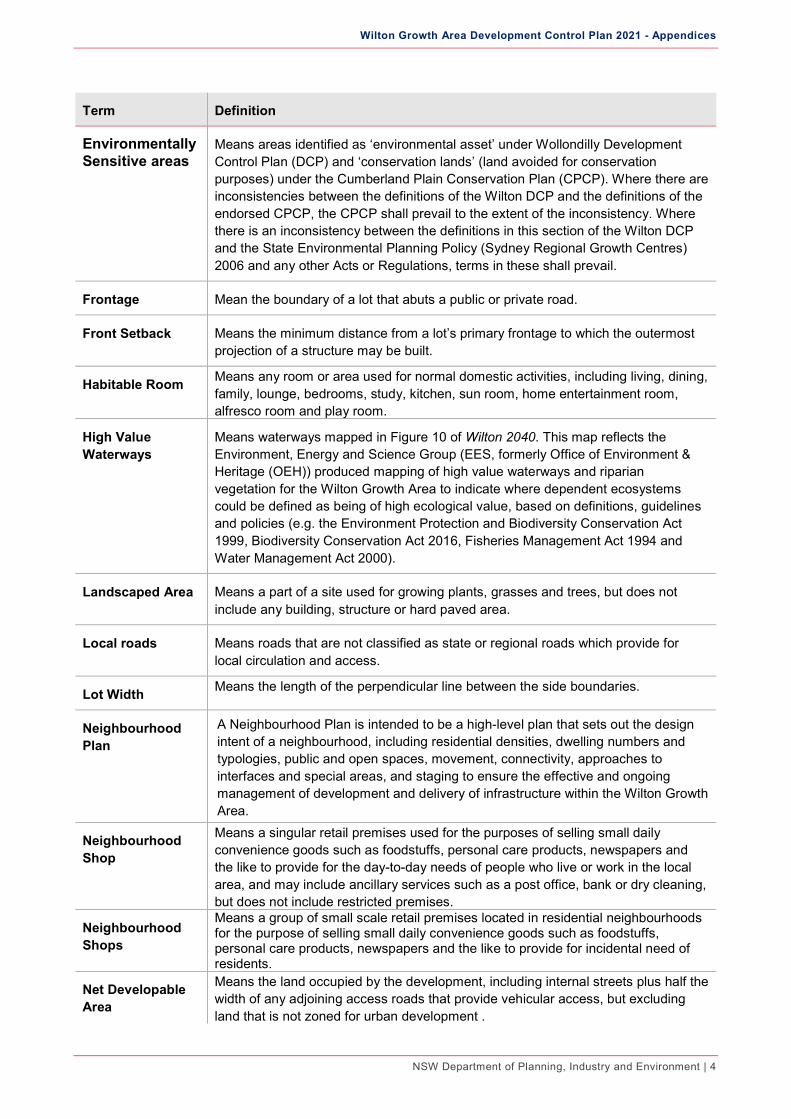
Appendix A Glossary Note: Definitions for terms are also included in the Dictionary contained within the Growth Centres SEPP, and in the
event of any inconsistency, the definition in the Growth Centres SEPP takes precedence over the definitions in this DCP.
Table 1: Glossary
Term Definition
Abutting Dwelling Means a building containing one dwelling, on a single block of land, that is designed and constructed on a zero lot line immediately adjacent to another dwelling on a different lot that is also built to the zero lot line and is structurally independent of any other dwelling.
Access Streets and Laneways
Provide local residential access to a small number of dwellings and serve a shared vehicular-pedestrian-cyclist use. They are intended to encourage a safe, low vehicle speed environment in which the residential function is dominant. Access streets function at the lowest level of the road hierarchy. They generally have development on one side and are located along drainage or open space reserves or along access-denied roads. The construction and dedication of access streets is the responsibility of the developer.
Active Frontages Are defined as one or a combination of the following: • entrance to retail; • shop front; • glazed entries to commercial and residential lobbies; • café or restaurant if accompanied by an entry from the street; • active office uses, such as reception, if visible from the street; and • public building if accompanied by an entry.
Annual Exceedance Probability (AEP)
Means the probability of exceedance of a given storm event within a period of one year.
Arterial Roads Means roads marked as such on the relevant Precinct (Schedule). They are major roads that carry the majority of inter-regional traffic. Vehicular access from adjacent land is denied to ensure both the efficiency of the road and the safety of road users.
Articulation elements
Includes verandahs, porches, awnings, shading devices, bay windows, pergolas, decorative cornices, columns and the like. A carport is not considered to be an articulation element.
Asset Protection Zone
Means an area surrounding a development which is intended to reduce bushfire risk. The width of the Asset Protection Zone will vary with slope and aspect.
Attached dwellings
Means 3 or more dwellings or separate lots that are joined by at least one-party wall.
Attic Means any habitable space, but not a separate dwelling, contained wholly within a roof above the ceiling line of the storey immediately below, except for minor elements such as dormer windows and the like.
Battle –Axe Lot Means a lot located behind another, with vehicle access from the street via an access handle. The minimum area specified for battle-axe lots excludes the battle-axe access handle.
Building Area Means the area of the site capable of supporting development. It does not include front, side and rear setbacks, or the access handle of a battle-axe lot.

Wilton Growth Area Development Control Plan 2021 - Appendices
NSW Department of Planning, Industry and Environment | 3
Term Definition
Building Envelope Means a three-dimensional diagram drawn on a lot of a subdivision plan. It defines the limits for the siting and/or height of any dwellings and/or buildings/structures, private outdoor areas, driveways and/or garages/carports.
Building Footprint Means the area of land measured at finished ground level that is enclosed by the external walls of a building.
Building Frontage Means the façade of the building that faces the primary frontage or street.
Building Height (or Height of Building)
Means the vertical distance between ground level (existing), at any point to the highest point of the building, including plant and lift overruns, but excluding communication devices, antennae, satellite dishes, masts, flagpoles, chimneys, flues and the like.
Car Space Means a garage, carport or other hard stand area constructed of materials suitable for car parking and access. The required car parking spaces specified above may be provided using a combination of these facilities, including use of the driveway (within the property boundary only) as a parking space.
Collector Roads Means roads marked as such on the relevant Precinct (Schedule). They are the main internal roads that carry local traffic through the residential neighbourhoods to the sub-arterial and arterial roads and provide access to major attractors within the precinct such as retail, commercial and educational facilities.
Connectivity Relates to the number and quality of connections in the movement network. It comprises streets, pedestrian/cycles paths/links and public buildings, or any type of open space that enables movement around or through an area.
Corner Lot Means a lot that has a frontage to two roads that intersect.
Detached Dwelling
Is a dwelling containing one dwelling, on a single block of land, that is not attached to any other dwelling.
Driveway Means the vehicle access between the property boundary and the building/ car space(s). The driveway is generally on private property, and is an extension of the Access Driveway.
Dual Occupancy Means a dual occupancy (attached) or a dual occupancy (detached).
Dual Occupancy (attached)
Means 2 dwellings on one lot of land that are attached to each other but does not include a secondary dwelling.
Dual Occupancy (detached)
Means 2 detached dwellings on one lot of land but does not include a secondary dwelling.
Ecological Setback
An ecological setback is located within the development footprint and is an area of vegetation not managed to improve condition. It provides a soften edge between the developable urban land and land with biodiversity values.
Wilton Growth Area Development Control Plan 2021 - Appendices
NSW Department of Planning, Industry and Environment | 4
Term Definition
Environmentally Sensitive areas
Means areas identified as ‘environmental asset’ under Wollondilly Development Control Plan (DCP) and ‘conservation lands’ (land avoided for conservation purposes) under the Cumberland Plain Conservation Plan (CPCP). Where there are inconsistencies between the definitions of the Wilton DCP and the definitions of the endorsed CPCP, the CPCP shall prevail to the extent of the inconsistency. Where there is an inconsistency between the definitions in this section of the Wilton DCP and the State Environmental Planning Policy (Sydney Regional Growth Centres) 2006 and any other Acts or Regulations, terms in these shall prevail.
Frontage Mean the boundary of a lot that abuts a public or private road.
Front Setback Means the minimum distance from a lot’s primary frontage to which the outermost projection of a structure may be built.
Habitable Room Means any room or area used for normal domestic activities, including living, dining, family, lounge, bedrooms, study, kitchen, sun room, home entertainment room, alfresco room and play room.
High Value Waterways
Means waterways mapped in Figure 10 of Wilton 2040. This map reflects the Environment, Energy and Science Group (EES, formerly Office of Environment & Heritage (OEH)) produced mapping of high value waterways and riparian vegetation for the Wilton Growth Area to indicate where dependent ecosystems could be defined as being of high ecological value, based on definitions, guidelines and policies (e.g. the Environment Protection and Biodiversity Conservation Act 1999, Biodiversity Conservation Act 2016, Fisheries Management Act 1994 and Water Management Act 2000).
Landscaped Area Means a part of a site used for growing plants, grasses and trees, but does not include any building, structure or hard paved area.
Local roads Means roads that are not classified as state or regional roads which provide for local circulation and access.
Lot Width Means the length of the perpendicular line between the side boundaries.
Neighbourhood Plan
A Neighbourhood Plan is intended to be a high-level plan that sets out the design intent of a neighbourhood, including residential densities, dwelling numbers and typologies, public and open spaces, movement, connectivity, approaches to interfaces and special areas, and staging to ensure the effective and ongoing management of development and delivery of infrastructure within the Wilton Growth Area.
Neighbourhood Shop
Means a singular retail premises used for the purposes of selling small daily convenience goods such as foodstuffs, personal care products, newspapers and the like to provide for the day-to-day needs of people who live or work in the local area, and may include ancillary services such as a post office, bank or dry cleaning, but does not include restricted premises.
Neighbourhood Shops
Means a group of small scale retail premises located in residential neighbourhoods for the purpose of selling small daily convenience goods such as foodstuffs, personal care products, newspapers and the like to provide for incidental need of residents.
Net Developable Area
Means the land occupied by the development, including internal streets plus half the width of any adjoining access roads that provide vehicular access, but excluding land that is not zoned for urban development .

Wilton Growth Area Development Control Plan 2021 - Appendices
NSW Department of Planning, Industry and Environment | 5
Term Definition
Net Residential Density
Means the net developable area in hectares of the land on which the development is situated, divided by the number of dwellings proposed to be located on that land. Net residential density includes the residential component plus local roads.
Non-Habitable Rooms
Means room spaces of a specialised nature not occupied frequently or for extended periods, including bathrooms, toilets, pantries, walk-in wardrobes, corridors, lobbies, photographic darkrooms and clothes drying rooms.
Outdoor Lighting Means any form of permanently installed exterior lighting and interior lighting systems that emit light impacts on the outdoor environment.
Outdoor Room Also known as an ‘alfresco room’ means a semi enclosed space (at least 1 side open) located adjacent a living / dining / kitchen area of a dwelling that sits within the main roof line of a dwelling.
Precinct Means a growth centre precinct.
Precinct Planning Principles
Precinct Planning Principles are contained in Wilton 2040 and guide development of the Precinct Plan. Refer to Appendix B for a full list of Precinct Planning Principles.
Precinct Structure Plan
Precinct Structure Plan provides for land use, infrastructure, and conservation requirements.
Principal Dwelling Means the largest dwelling house on a lot, measured by gross floor area.
Principal Private Open Space
Means the portion of private open space which is conveniently accessible from a living zone of the dwelling, and which receives the required amount of solar access.
Private Open Space
Means an area external to a building (including an area of land, terrace, balcony or deck) that is used for private outdoor purposes ancillary to the use of the building.
Relevant Precinct (Schedule)
South East Wilton Precinct (Schedule) – as shown in Schedule 1 of this DCP. North Wilton Precinct (Schedule) – as shown in Schedule 2 of this DCP.
Riparian Corridor Means the core riparian zone and vegetated buffer as shown in the relevant precinct (schedule).
Secondary Dwelling
Means a self-contained dwelling that—
is established in conjunction with another dwelling (the principal dwelling), and
is on the same lot of land as the principal dwelling, and
is located within, or is attached to, or is separate from, the principal dwelling.
Semi-Detached Dwellings
Means a dwelling that is on its own lot of land and is attached to only one other dwelling but does not include a studio dwelling.
Site Analysis Means the identification and analysis of the existing urban character and adjacent properties. It is designed to assist in understanding the locality and inform appropriate design responses.

Wilton Growth Area Development Control Plan 2021 - Appendices
NSW Department of Planning, Industry and Environment | 6
Term Definition
Site Coverage Means the proportion of a site area covered by buildings. However, the following are not included for the purpose of calculating site coverage—
any basement,
any part of an awning that is outside the outer walls of a building and that adjoins the street frontage or other site boundary,
any eaves,
unenclosed balconies, decks, pergolas and the like.
Sub-Arterial Roads
Means roads marked as such on the Relevant Precinct (Schedule). Sub-arterial roads link regional and local traffic routes. Access from private properties is generally denied to these roads (except in special circumstances) for reasons of traffic safety and to maintain the capacity and efficiency of the road system. Council is normally responsible for the acquisition and construction of sub-arterial roads.
Urban Tree Canopy
Means the total urbanised land area occupied by layers of leaves, branches and stems of trees that cover the ground when viewed from above. It is the measure of the total horizontal extent of the combined tree canopies on a given urban land area.
Walking Distance Means typically 400m or a 5-minute walk.
Note: definitions for terms are also included in the Dictionary contained within the Growth Centres SEPP, and in the
event of any inconsistency, the definition in the Growth Centres SEPP takes precedence over the definitions in this DCP.

Wilton Growth Area Development Control Plan 2021 - Appendices
NSW Department of Planning, Industry and Environment | 7
Appendix B Precinct Planning Principles The Wilton Growth Area Precinct Planning Principles contained in Wilton 2040 – A Plan for the Wilton Growth Area (28 September 2018) should inform the preparation of the Precinct Schedules and Neighbourhood Plans. The following principles are based on Wilton 2040.
Note: Several planning principles listed below are reflective of post-exhibition submissions assessment.
Social Infrastructure The Precinct Schedule and Neighbourhood Plans must:
locate large facilities that also service a district or region in the Wilton Town Centre
co-locate social infrastructure with new or local open space or integrate facilities as multi-use clusters or social hubs
Green Tree Canopy/Corridors The Precinct Schedule and Neighbourhood Plans must:
create walkability and accessibility to local centres and social infrastructure
create healthy, liveable places, and respond to climate change, for example by promoting cooling effects
strengthen resilience in communities and capacity to adapt to future changes
create opportunities for green canopies and links
provide shade and encourage outdoor activity
support healthy ecosystems and biological diversity
Heritage The Precinct Schedule and Neighbourhood Plans must:
recognise the history, heritage and character of the Wilton Growth Area in a new urban environment through identifying and retaining Non-Aboriginal and Aboriginal Cultural Heritage elements within the precincts
be informed by Aboriginal Cultural Heritage Assessments, including consultation with the Aboriginal Community
take into account the protection of Aboriginal Cultural Heritage items and places in the design of the precinct layout
Landscape Protecting and Enhancing Important Habitats The Precinct Schedule and Neighbourhood Plans must:
be consistent with the biodiversity conservation measures identified in the draft Cumberland Plain Conservation Plan
ensure stormwater management design minimises impact on the biodiversity values of conservation areas
support measures to protect primary koala habitat and corridors in perpetuity, and to restore land to augment and strengthen existing koala corridors

Wilton Growth Area Development Control Plan 2021 - Appendices
NSW Department of Planning, Industry and Environment | 8
identify areas where development controls are required to reduce on-going threats to koalas
be in accordance with the approved strategic bio-certification and strategic assessment
Wilton Green Plan Refer to Appendix E for a list of principles guiding the Wilton Green Plan.
Waterway Health The Precinct Schedule and Neighbourhood Plans must:
incorporate development that protects, maintains or restores waterway health and the community’s environmental values and uses of waterways through a risk-based approach to managing the cumulative impacts of development
ensure an integrated approach to drinking water, wastewater and stormwater services is considered to drive more sustainable water management outcomes
incorporate development that fosters the relationship between water, landscapes and urban living, to enhance human and social wellbeing, and promote community co-design and governance in urban water strategies
Bushfire Protection The Precinct Schedule and Neighbourhood Plans must:
ensure that bushfire protection measures including safe evacuation routes are considered in the layout and development of the local street network
incorporate Asset Protection Zones and perimeter roads in the design of urban development areas based on the level of bushfire hazard exposure
ensure that defendable community assets are located in safe refuge areas
Land Use Managing Land Use Activities The Precinct Schedule and Neighbourhood Plans must:
plan for a well-designed interface between residential and industrial or commercial land to minimise potential for impacts on residential amenity
minimise air quality impacts on sensitive land uses by application of setbacks from busy road corridors and ameliorative design measures, or install high performance mechanical ventilation systems
consider potential impacts (noise, odour, safety) of existing and future land uses on existing or future nearby or adjoining sensitive land uses, such as residences, schools, child care centres, hospitals and aged care centres
Built Form The Precinct Schedule and Neighbourhood Plans must:
adopt the objectives from the NSW Government Architect’s “Better Placed – An integrated Design Policy for the Built Environment of New South Wales” (September 2017) to achieve a better:
o fit (Locally, Contextually, Of its Place)

Wilton Growth Area Development Control Plan 2021 - Appendices
NSW Department of Planning, Industry and Environment | 9
o performance (Sustainable, Adaptable, Durable)
o outcome for the community (Inclusive, Connected, Diverse)
o outcome for people (Safety, Comfortable, Liveable)
o working (Functional, Efficient, Fit for purpose)
o value (Creating and adding value by increased social, economic and environmental benefits to the community)
o look and feel (Engaging, Inviting, Attractive)
“Design with Country” to provide for Aboriginal and Torres Strait Islander peoples’ knowledge of Country, and the knowledge held within Country, to bring together all the complex elements of place into a holistic understanding. The sharing of knowledge between peoples offers an opportunity to find common ground to support the health and wellbeing of Country.
plan for diverse typologies to suit a range of ages
integrate technology that contributes to and promotes achievement of the NSW Government’s target of net-zero carbon emissions by 2050
introduce opportunities for sustainable and efficient use of resources to minimise waste, water and energy from development
consider process and principles contained in Crime Prevention and The Assessment of Development Applications Guidelines (NSW Minister for Planning, 2001)
Residential Density The Neighbourhood Plans must:
ensure residential development does not exceed the dwelling cap contained in the Growth Centres SEPP. Neighbourhood Plans should indicate the number of dwellings proposed in each neighbourhood as a mechanism for tracking compliance with the Precinct dwelling cap.
comply with Clause 4.3A Residential density (Appendices 14 and 15) of the Growth Centres SEPP
Movement The Precinct Schedule and Neighbourhood Plans must:
provide a hierarchy of roads to ensure safe, efficient movement of vehicles and pedestrians, the free flow of freight, and minimise conflicts between through and local traffic and residential amenity
provide convenient and safe walking and cycling connections throughout the neighbourhood, across major roads, and to open space, schools and centres
ensure homes are within walking distance of a bus stop and that bus routes link key centres, transport hubs, schools, employment opportunities and residential areas
reserve sufficient land for future transport corridors, social and physical infrastructure to cater for population growth
ensure adequate site and design development adjoining infrastructure corridors to address potential noise impacts
connect the Wilton Town Centre and the existing Wilton village
integrate land use and transport to align travel needs with infrastructure and services to support the land use change

Wilton Growth Area Development Control Plan 2021 - Appendices
NSW Department of Planning, Industry and Environment | 10
consider alternative modes of transport in the planning for local road networks, including measures to encourage walking and cycling and access for public transport, community transport and taxis
include walking and cycling routes, especially alongside areas where many people move to encourage more active modes of travel
encourage walking and cycling within and to and from the Growth Area
Wilton Town Centre The Wilton Town Centre Precinct Plan and Neighbourhood Plans must:
support the early delivery of a mix of uses to gain a foothold in the market and momentum to reach maturity
provide flexible land use and lot size controls to enable the centre to evolve in line with the growing population and long-term strategic vision
deliver the infrastructure necessary to unlock the centre’s establishment and growth
design high quality public areas based around open spaces that are comfortable for walking. A plaza, town centre park or town square should be a focal point for people to interact and include a variety of formal and informal seating, landscape treatments and weather protection
provide crossings over Picton Road and the Hume Motorway to facilitate safe, convenient and direct access to the district centre from across the Growth Area
provide end-of-trip facilities alongside vehicle parking in commercial areas to encourage walking and cycling
underground or sleeve parking areas and large format retail with specialty retail stores that create a more active street front

Wilton Growth Area Development Control Plan 2021 - Appendices
NSW Department of Planning, Industry and Environment | 11
Appendix C High Value Waterways: Table of Indicators
This table of indicators identifies the waterway and riparian values requiring protection and/or restoration or rehabilitation under Objective 3.6.1 of this DCP. The indicators consist of those identified as high value under guidelines and policies for administering relevant environment and planning legislation in NSW. Specifically, Environment Protection and Biodiversity Conservation Act 1999, Biodiversity Conservation Act 2016, Fisheries Management Act 1994 and Water Management Act 2000.
The habitat and ecological requirements of the indicators must be considered for all developments that are associated with, or that will affect the high value waterways and riparian areas as set out in Figure 10 of Wilton 2040. The habitat and ecological requirements set out in the indicators listed in Table 2, establish benchmarks for protection and/or restoration or rehabilitation.
Table 2: High Value Waterways: Table of Indicators
MAP ATTRIBUTE
DESCRIPTION INDICATOR LEGISLATION &/OR POLICY
PU_ID Wilton Priority Growth Area was broken into 1 hectare hexagons for determining the extent (area, length, presence) of water dependent ecosystems. The 1 hectare hexagons are called planning units, and each unit has a unique identifier.
n/a n/a
TVALUE Total extent of water dependent ecosystems and reserves within a planning unit. Extent was based on the sum of the area (m2), length (m) or presence of an ecosystem, community or species recognised as high value in State Planning Policy and/or Legislation.
n/a n/a
RESERVES Total extent of National Parks Wildlife Service and Crown Land Estate dedicated to conservation within a planning unit based on the sum of area (m2).
Reserves National Parks and Wildlife Act 1974; Crown Lands Act 1989
MSW Total extent of the Moist Shale Woodland in the Sydney Basin Bioregion EEC within a planning unit based on the sum of area (m2).
Ecologically Endangered Community
Biodiversity Conservation Act, 2016

Wilton Growth Area Development Control Plan 2021 - Appendices
NSW Department of Planning, Industry and Environment | 12
MAP ATTRIBUTE
DESCRIPTION INDICATOR LEGISLATION &/OR POLICY
RFEF Total extent of the River Flat Eucalypt Forest on Coastal Floodplains of the NSW NC, SB and SEC bioregions EEC within a planning unit based on the sum of area (m2).
Ecologically Endangered Community
Biodiversity Conservation Act, 2016
WSDFM Total extent of the Western Sydney Dry Rainforest and Moist Woodland on Shale EEC within a planning unit based on the sum of area (m2).
Ecologically Endangered Community
Biodiversity Conservation Act, 2016
WSDR Total extent of the Western Sydney Dry Rainforest in the Sydney Basin Bioregion EEC within a planning unit based on the sum of area (m2).
Ecologically Endangered Community
Biodiversity Conservation Act, 2016
LEPRIP Total extent of the Local Environment Plan designated riparian zones within a planning unit based on the sum of area (m2).
Riparian Lands and Watercourses Standard Instrument Order 2006
PRIHAB Total extent of the designated Upland Swamp and Alluvial Forest Woodland priority habitat zones within a planning unit based on the sum of area (m2).
Priority Habitat Areas Standard Instrument Order 2006
CMSW Total extent of the Cumberland Moist Shale Woodland PCT within a planning unit based on the sum of area (m2).
Wetland and Riparian Vegetation Biodiversity Conservation Act, 2016; NSW Wetlands Policy
CRFF Total extent of the Cumberland River Flat Forest PCT within a planning unit based on the sum of area (m2).
Wetland and Riparian Vegetation Biodiversity Conservation Act, 2016; NSW Wetlands Policy
GMDR Total extent of the Grey Myrtle Dry Rainforest PCT within a planning unit based on the sum of area (m2).
Wetland and Riparian Vegetation Biodiversity Conservation Act, 2016; NSW Wetlands Policy
HSGF Total extent of the Hinterland Sandstone Gully Forest PCT within a planning unit based on the sum of area (m2).
Wetland and Riparian Vegetation Biodiversity Conservation Act, 2016; NSW Wetlands Policy
SRS Total extent of the Sandstone Riparian Scrub PCT within a planning unit based on the sum of area (m2).
Wetland and Riparian Vegetation Biodiversity Conservation Act, 2016; NSW Wetlands Policy
Wilton Growth Area Development Control Plan 2021 - Appendices
NSW Department of Planning, Industry and Environment | 13
MAP ATTRIBUTE
DESCRIPTION INDICATOR LEGISLATION &/OR POLICY
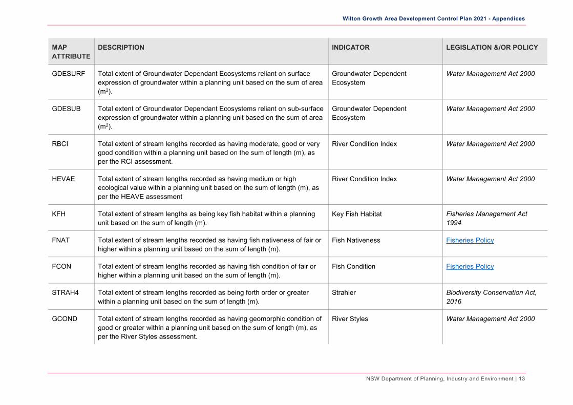
GDESURF Total extent of Groundwater Dependant Ecosystems reliant on surface expression of groundwater within a planning unit based on the sum of area (m2).
Groundwater Dependent Ecosystem
Water Management Act 2000
GDESUB Total extent of Groundwater Dependant Ecosystems reliant on sub-surface expression of groundwater within a planning unit based on the sum of area (m2).
Groundwater Dependent Ecosystem
Water Management Act 2000
RBCI Total extent of stream lengths recorded as having moderate, good or very good condition within a planning unit based on the sum of length (m), as per the RCI assessment.
River Condition Index Water Management Act 2000
HEVAE Total extent of stream lengths recorded as having medium or high ecological value within a planning unit based on the sum of length (m), as per the HEAVE assessment
River Condition Index Water Management Act 2000
KFH Total extent of stream lengths as being key fish habitat within a planning unit based on the sum of length (m).
Key Fish Habitat Fisheries Management Act 1994
FNAT Total extent of stream lengths recorded as having fish nativeness of fair or higher within a planning unit based on the sum of length (m).
Fish Nativeness Fisheries Policy
FCON Total extent of stream lengths recorded as having fish condition of fair or higher within a planning unit based on the sum of length (m).
Fish Condition Fisheries Policy
STRAH4 Total extent of stream lengths recorded as being forth order or greater within a planning unit based on the sum of length (m).
Strahler Biodiversity Conservation Act, 2016
GCOND Total extent of stream lengths recorded as having geomorphic condition of good or greater within a planning unit based on the sum of length (m), as per the River Styles assessment.
River Styles Water Management Act 2000

Wilton Growth Area Development Control Plan 2021 - Appendices
NSW Department of Planning, Industry and Environment | 14
MAP ATTRIBUTE
DESCRIPTION INDICATOR LEGISLATION &/OR POLICY
RPOT Total extent of stream lengths recorded as having recovery potential of high or conservation within a planning unit based on the sum of length (m), as per the River Styles assessment.
River Styles Water Management Act 2000
FISHMP Total extent of stream lengths recorded as being potential for the threatened species Macquarie Perch within a planning unit based on the sum of length (m).
Threatened Fish Habitat Fisheries Management Act 1994
FISHSHD Total extent of stream lengths recorded as being potential habitat for the threatened species Sydney Hawk Dragonfly within a planning unit based on the sum of length (m).
Threatened Fish Habitat Fisheries Management Act 1994
BIRDAI Total number of observations for the important migratory species Ardea ibis within a planning unit based on the count of species observations.
Migratory Bird Species Sightings International and bilateral agreements
BIRDHL Total number of observations for the important migratory species Haliaeetus leucogaster within a planning unit based on the count of species observations.
Migratory Bird Species Sightings International and bilateral agreements
BIRDMO Total number of observations for the important migratory species Merops ornatus within a planning unit based on the count of species observations.
Migratory Bird Species Sightings International and bilateral agreements
FLORA1 Total number of observations for the threatened plant species identified as definite indicators of riverine and wetland habitats within a planning unit based on the count of species observations.
Threatened Flora Sightings Biodiversity Conservation Act, 2016
FLORA2 Total number of observations for the threatened plant species identified as likely indicators of riverine and wetland habitats within a planning unit based on the count of species observations.
Threatened Flora Sightings Biodiversity Conservation Act, 2016
FLORA3 Total number of observations for the threatened plant species identified as possible indicators of riverine and wetland habitats within a planning unit based on the count of species observations.
Threatened Flora Sightings Biodiversity Conservation Act, 2016

Wilton Growth Area Development Control Plan 2021 - Appendices
NSW Department of Planning, Industry and Environment | 15
MAP ATTRIBUTE
DESCRIPTION INDICATOR LEGISLATION &/OR POLICY
FAUNAAP Total number of observations for the threatened fauna species Anthochaera Phrygia within a planning unit based on the count of species observations.
Threated Fauna Sightings Biodiversity Conservation Act, 2016
FAUNACD Total number of observations for the threatened fauna species Chalinolobus dwyeri within a planning unit based on the count of species observations.
Threated Fauna Sightings Biodiversity Conservation Act, 2016
FAUNACS Total number of observations for the threatened fauna species Chthonicola sagittata within a planning unit based on the count of species observations.
Threated Fauna Sightings Biodiversity Conservation Act, 2016
FAUNADM Total number of observations for the threatened fauna species Dasyurus maculatus within a planning unit based on the count of species observations.
Threated Fauna Sightings Biodiversity Conservation Act, 2016
FAUNAFT Total number of observations for the threatened fauna species Falsistrellus tasmaniensis within a planning unit based on the count of species observations.
Threated Fauna Sightings Biodiversity Conservation Act, 2016
FAUNAGP Total number of observations for the threatened fauna species Glossopsitta pusilla within a planning unit based on the count of species observations.
Threated Fauna Sightings Biodiversity Conservation Act, 2016
FAUNAHL Total number of observations for the threatened fauna species Haliaeetus leucogaster within a planning unit based on the count of species observations.
Threated Fauna Sightings Biodiversity Conservation Act, 2016
FAUNAHM Total number of observations for the threatened fauna species Hieraaetus morphnoides within a planning unit based on the count of species observations.
Threated Fauna Sightings Biodiversity Conservation Act, 2016
FAUNALI Total number of observations for the threatened fauna species Lophoictinia isura within a planning unit based on the count of species observations.
Threated Fauna Sightings Biodiversity Conservation Act, 2016

Wilton Growth Area Development Control Plan 2021 - Appendices
NSW Department of Planning, Industry and Environment | 16
MAP ATTRIBUTE
DESCRIPTION INDICATOR LEGISLATION &/OR POLICY
FAUNAMC Total number of observations for the threatened fauna species Meridolum corneovirens within a planning unit based on the count of species observations.
Threated Fauna Sightings Biodiversity Conservation Act, 2016
FAUNAMA Total number of observations for the threatened fauna species Miniopterus australis within a planning unit based on the count of species observations.
Threated Fauna Sightings Biodiversity Conservation Act, 2016
FAUNAMF Total number of observations for the threatened fauna species Mormopterus norfolkensis within a planning unit based on the count of species observations.
Threated Fauna Sightings Biodiversity Conservation Act, 2016
FAUNAMM Total number of observations for the threatened fauna species Myotis macropus within a planning unit based on the count of species observations.
Threated Fauna Sightings Biodiversity Conservation Act, 2016
FAUNANP Total number of observations for the threatened fauna species Neophema pulchella within a planning unit based on the count of species observations.
Threated Fauna Sightings Biodiversity Conservation Act, 2016
FAUNANC Total number of observations for the threatened fauna species Ninox connivens within a planning unit based on the count of species observations.
Threated Fauna Sightings Biodiversity Conservation Act, 2016
FAUNAPA Total number of observations for the threatened fauna species Petaurus australis within a planning unit based on the count of species observations.
Threated Fauna Sightings Biodiversity Conservation Act, 2016
FAUNAPN Total number of observations for the threatened fauna species Petaurus norfolcensis within a planning unit based on the count of species observations.
Threated Fauna Sightings Biodiversity Conservation Act, 2016
FAUNAPB Total number of observations for the threatened fauna species Petroica boodang within a planning unit based on the count of species observations.
Threated Fauna Sightings Biodiversity Conservation Act, 2016

Wilton Growth Area Development Control Plan 2021 - Appendices
NSW Department of Planning, Industry and Environment | 17
MAP ATTRIBUTE
DESCRIPTION INDICATOR LEGISLATION &/OR POLICY
FAUNAPP Total number of observations for the threatened fauna species Pteropus poliocephalus within a planning unit based on the count of species observations.
Threated Fauna Sightings Biodiversity Conservation Act, 2016
FAUNASR Total number of observations for the threatened fauna species Scoteanax rueppellii within a planning unit based on the count of species observations.
Threated Fauna Sightings Biodiversity Conservation Act, 2016
FAUNASG Total number of observations for the threatened fauna species Stagonopleura guttata within a planning unit based on the count of species observations.
Threated Fauna Sightings Biodiversity Conservation Act, 2016
FAUNATN Total number of observations for the threatened fauna species Tyto novaehollandiae within a planning unit based on the count of species observations.
Threated Fauna Sightings Biodiversity Conservation Act, 2016
Wilton Growth Area Development Control Plan 2021 - Appendices
NSW Department of Planning, Industry and Environment | 18
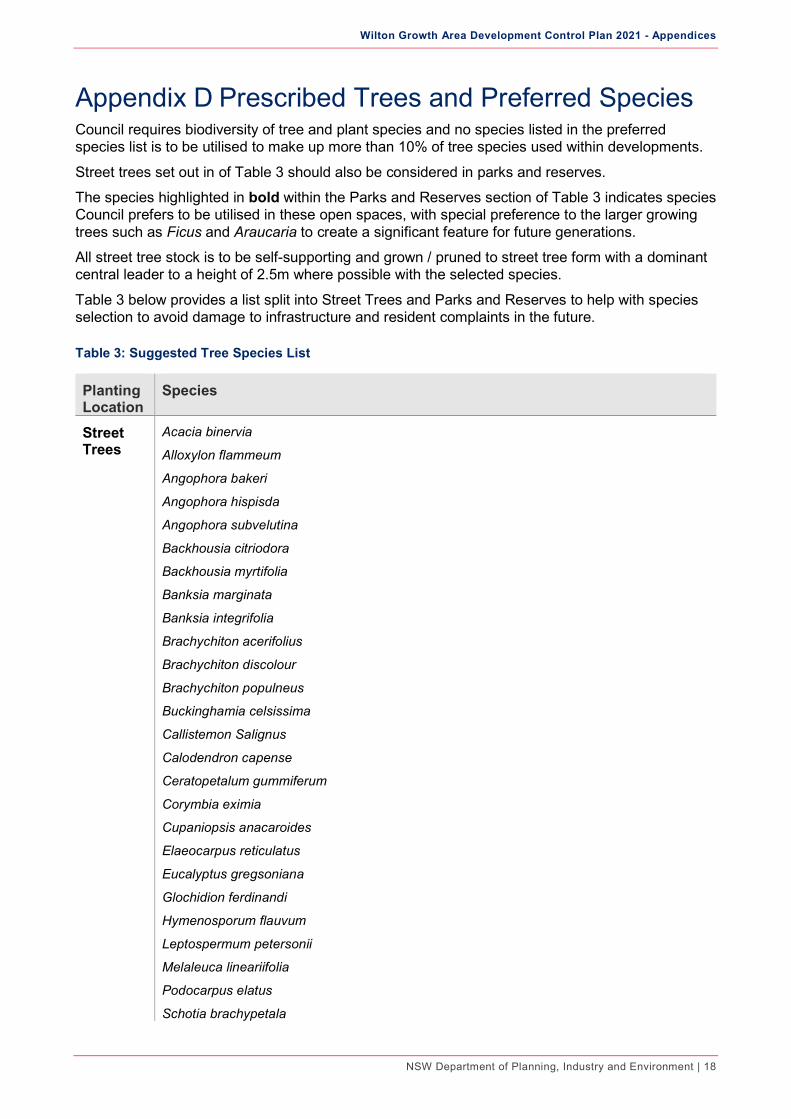
Appendix D Prescribed Trees and Preferred Species Council requires biodiversity of tree and plant species and no species listed in the preferred species list is to be utilised to make up more than 10% of tree species used within developments.
Street trees set out in of Table 3 should also be considered in parks and reserves.
The species highlighted in bold within the Parks and Reserves section of Table 3 indicates species Council prefers to be utilised in these open spaces, with special preference to the larger growing trees such as Ficus and Araucaria to create a significant feature for future generations.
All street tree stock is to be self-supporting and grown / pruned to street tree form with a dominant central leader to a height of 2.5m where possible with the selected species.
Table 3 below provides a list split into Street Trees and Parks and Reserves to help with species selection to avoid damage to infrastructure and resident complaints in the future.
Table 3: Suggested Tree Species List
Planting Location
Species
Street Trees
Acacia binervia
Alloxylon flammeum
Angophora bakeri
Angophora hispisda
Angophora subvelutina
Backhousia citriodora
Backhousia myrtifolia
Banksia marginata
Banksia integrifolia
Brachychiton acerifolius
Brachychiton discolour
Brachychiton populneus
Buckinghamia celsissima
Callistemon Salignus
Calodendron capense
Ceratopetalum gummiferum
Corymbia eximia
Cupaniopsis anacaroides
Elaeocarpus reticulatus
Eucalyptus gregsoniana
Glochidion ferdinandi
Hymenosporum flauvum
Leptospermum petersonii
Melaleuca lineariifolia
Podocarpus elatus
Schotia brachypetala

Wilton Growth Area Development Control Plan 2021 - Appendices
NSW Department of Planning, Industry and Environment | 19
Planting Location
Species
Stenocarpus sinuatus
Tristaniopsis laurina and cultivars
Waterhousia floribunda and cultivars
Parks and Reserves Trees
Agathis robusta
Allocasuarina littoralis
Allocasuarina torulosa
Angophora costata
Angophora floribunda
Araucaria collumnaris
Araucaria cunninghamiana
Araucaria heterophylla
Callitris rhomboidea
Casuarina cunninghamiana
Corymbia gummifera
Eucalyptus agglomerata - Supplementary Koala Food Trees
Eucalyptus amplifolia - Supplementary Koala Food Trees
Eucalyptus baueriana
Eucalyptus eugenoides - Supplementary Koala Food Trees
Eucalyptus globoidea - Supplementary Koala Food Trees
Eucalyptus haemastoma
Eucalyptus longifolia – Secondary Koala Food Trees
Eucalyptus maculata
Eucalyptus melliodora
Eucalyptus moluccana - Secondary Koala Food Trees
Eucalyptus notabilis - Supplementary Koala Food Trees
Eucalyptus parramattensis - Supplementary Koala Food Trees
Eucalyptus pilularis
Eucalyptus punctata - Secondary Koala Food Trees
Eucalyptus quadrangulata - Supplementary Koala Food Trees
Eucalyptus resinifera - Supplementary Koala Food Trees
Eucalyptus scias - Supplementary Koala Food Trees
Eucalyptus sclerophylla
Eucalyptus sideroxylon and “rosea”
Eucalyptus tereticornis – Primary Koala Food Trees
Eucalyptus viminalis - Primary Koala Food Trees
Ficus macrophylla

Wilton Growth Area Development Control Plan 2021 - Appendices
NSW Department of Planning, Industry and Environment | 20
Planting Location
Species
Ficus rubiginosa
Melaleuca decora
Melaleuca styphelioides
Melia azedarach
Metasequoia glyptostroboides
Syncarpia glomulifera
Syzygium francessii
Syzygium leumahnii
Syzygium (Acmena) smithii
Syzygium paniculatum and cultivars

Wilton Growth Area Development Control Plan 2021 - Appendices
NSW Department of Planning, Industry and Environment | 21
Appendix E Green Principles Objectives Green principles have been established for the provision of open space and urban tree canopy within the Wilton Growth Area.
Overarching Principles
To support the implementation of the long-term open space for recreation, open space for biodiversity and urban tree canopy vision for the Wilton Growth Area, a series of overarching principles have been identified.

Wilton Growth Area Development Control Plan 2021 - Appendices
NSW Department of Planning, Industry and Environment | 22
Figure 1: Green Overarching Principles
Based on these overarching Green Principles, seven place specific design principles have been generated to guide the decision-making process in the assessment and interventions of open space and urban tree canopy. Figure 2 describes what these principles are and an outline how to achieve this.

Wilton Growth Area Development Control Plan 2021 - Appendices
NSW Department of Planning, Industry and Environment | 23
Figure 2: Green Design Principles
1 DESIGN PRINCIPLE
Connect the community
Create a system of hierarchical Green Links and linear parks to establish a continuous network of open space that connects the community with quality recreational areas.
Achieve this by: • Implementing a network of pedestrian
and cycling links to the greater network of open space throughout Wilton Growth Area and beyond;
• Linking the proposed new town centres, schools and other community facilities with a network of open spaces;
• Align Green Links with pedestrian and active transport desire lines including sub arterial and collector roads where applicable;
• Connecting Green Links with the ecological fringe; where applicable; and
• Implementing Green Links that are safe, comfortable and have a high-quality finish.

Wilton Growth Area Development Control Plan 2021 - Appendices
NSW Department of Planning, Industry and Environment | 24
2 DESIGN PRINCIPLE
Mitigate bushfire risk
Reinforce a landscape-managed edge (APZ) and evacuation zones by the strategic placement of open space assets and multi-functional physical buffers that offer fire safety, recreational opportunities and ecological protection.
Achieve this by:
Retaining and utilising the APZ to create a framework for publicly accessible linear parks along the bushland edges as applicable.
Activating the required APZ by:
– Providing open space (where applicable) which responds to site characteristics and condition;
– Incorporating WSUD outcomes to increase permeability and assist in maintaining waterway health;
– Protecting native flora and fauna conservation; and
– Facilitating community interaction and education of the conservation areas to build awareness and sense of ownership.
Utilising and co-locating open space with APZ and evacuation zones in the areas that are not identified as high bushfire risk, in line with the NSW Rural Fire Service Planning for Bushfire Protection 2019.

Wilton Growth Area Development Control Plan 2021 - Appendices
NSW Department of Planning, Industry and Environment | 25
3 DESIGN PRINCIPLE
Apply Koala Sensitive Urban Design (KSUD) principles
Support strategies for safe refuge and movement of native fauna in an urban environment, through well connected open spaces, community education and awareness to reduce threats to transient Koala and other fauna species.
Achieve this by:
Creating a strategic framework to support the conservation and protection of the native flora and fauna by mitigating edge effects;
Identifying potential pinch-points within conservation land as possible locations for interaction between the community and native flora and fauna, including potential Koala look out points; and
Co-locating open space adjoining conservation areas to maximise the buffer zones between Koala habitat and urbanised areas, where applicable.

Wilton Growth Area Development Control Plan 2021 - Appendices
NSW Department of Planning, Industry and Environment | 26
4 DESIGN PRINCIPLE
Leverage the existing character and heritage
Protect, enhance and respond to the unique landscape features and Aboriginal and European heritage assets through co- location of open space and direct connection through the wider link network.
Achieve this by:
Retaining and conserving significant heritage sites;
Investigating opportunities to create a diversity of open space experiences through the conservation and interpretation of key heritage sites and artefacts, for the education and enrichment of the community; and
Developing a Green Link strategy that aligns with pedestrian and active transport desire lines orientated towards the identified heritage sites.

Wilton Growth Area Development Control Plan 2021 - Appendices
NSW Department of Planning, Industry and Environment | 27
5 DESIGN PRINCIPLE
Provide equal distribution of active and passive recreational facilities
Ensure a balanced approach to active and passive recreational facilities is achieved, that meets the recreation needs of the growing Wilton community.
Achieve this by:
Providing a diverse range of accessible community spaces and recreational facilities within the precincts to ensure streets and open spaces are activated;
Delivering an equitable and even distribution of open space (both active and passive recreational spaces) within the Wilton Growth Area;
Assessing the distribution and quality of proposed open space parcels to achieve a 400-800m (10 minutes’) walking catchment for 95% of future residents; and
Implementing high quality open spaces with a clear hierarchy of open space types to allow for a diversity in programming and use.

Wilton Growth Area Development Control Plan 2021 - Appendices
NSW Department of Planning, Industry and Environment | 28
6 DESIGN PRINCIPLE
Apply Water Sensitive Urban Design (WSUD) principles
Support the permeation, treatment and reuse of water through a combination of WSUD strategies integrated into the open space assets and streets, to assist with the cooling and greening of the Wilton Growth Area.
Apply WSUD that aligns with and adds value to:
Open space, streets and associated landscaping;
Water conservation;
Passive recreation;
Mitigating localised heat island effects; and
Biodiversity conservation.

Wilton Growth Area Development Control Plan 2021 - Appendices
NSW Department of Planning, Industry and Environment | 29
7 DESIGN PRINCIPLE
Cooling Wilton
Implement strategies to protect and enhance the existing and creating new tree canopy density, which will contribute to an overall cooling of the Wilton Growth Area.
Achieve this by:
Retaining mature vegetation and tree clusters where possible;
Enhancing and increasing the urban tree canopy in streets, open spaces and government owned land;
Considering appropriate street tree planting species that support the local character and assist in achieving the set urban tree canopy targets;
Setting urban canopy strategic directions to implement and achieve set canopy target while mitigating fire risk; and
Co-locating open space and align green links with existing tree clusters to assist in retaining and protecting existing tree canopy throughout the growth area.