wigan m58 link road · 2018-02-12 · the three main scheme objectives are: • enhanced...
TRANSCRIPT

Wigan M58 Link Road – Executive Summary
1
Wigan M58 Link Road
Executive Summary
Wigan Council
Published February 2018
Wigan M58 Link Road – Executive Summary
2
Objectives and Strategic Case
The M58 Link Road (M58 LR) is a new 2.3km single carriageway link between Junction 6 of the M58 & Junction 26 of the M6 and the southern part of Wigan Town Centre.
It provides a new high profile gateway into Wigan town centre from the M58/M6 and connects a number of key employment sites to the strategic highway network, bringing the opportunity to create new jobs and directly contributing to the Council’s economic growth strategy to increase the borough’s economy.
The three main scheme objectives are:
• Enhanced Connectivity;
• Reduced Congestion; and
• Economic Growth.
These are a consistent element throughout the Council’s Transport Strategy and relate particularly well to the M58 Link given the improved connection to the M6 at junction 26, the existing congestion problems along the A577 Ormskirk Road and the improved strategic network connectivity which the scheme will deliver.
The new link road addresses a severe weakness in Wigan’s transport network, namely a lack of connectivity between the M58 and M6 and the town centre. In conjunction with the A49 Link Road the new road forms a major piece in the jigsaw to improve east-west connections across the borough, complementing and supporting the other components of Wigan’s transport strategy.
The provision of connected infrastructure is a vital part of the Council’s economic growth strategy. Improved access to national networks will help attract investment and businesses to Greater Manchester and make existing businesses more competitive.
The M58 LR is a crucial element in improving the Borough’s accessibility and will boost the economic performance and profile of Wigan by regenerating existing employment sites, facilitating the development of new employment sites and assisting in establishing new residential developments.
As Wigan has now also been confirmed as a station hub for the new High Speed Rail (HS2) service, improved connectivity between the station and the strategic road network is more vital than ever to realise the full regeneration and growth potential of this.
The proposed M58 link road itself incorporates a new shared use path along its length, providing enhanced sustainable transport connections for local trips between communities and to the town centre. With its connection into the new A49 link road, the M58LR will provide a continuous sustainable travel link to the local facilities along the Poolstock corridor, the canal towpath and Wigan Flashes, boosting the Council’s leisure offer and encouraging modal shift.
The M58 scheme has been shown to represent very high overall Value for Money, which is increased further when other infrastructure elements of the transport strategy, including the A49 link road and the completed Marus Bridge Pinch Point Scheme, are also taken into account.
The M58 Link Road scheme has been developed using lessons learned from the A49 Link Road, and based on similar risk management, governance and reporting processes which have been developed with support and input from Transport for Greater Manchester (TfGM). Due to this, we are confident that we have all the necessary supporting processes in place to ensure successful delivery, allowing the team to focus on the scheme-specific risks and issues.

Wigan M58 Link Road – Executive Summary
3
The Greater Manchester Combined Authority has allocated £10.9 million of Growth Deal (GD) funding to the scheme and £5 million Growth and Housing Funding (GHF) has been approved from Highways England. There is an emerging development agreement with a private sector party to connect the link road through to the A49 through the Pemberton colliery site, between Smithy Brook Road and A571 Billinge Road.
The Council remains committed to bridging any funding gap identified to support the full delivery of the scheme, which will be achieved through a combination of securing funding contributions and robust cost management.
In parallel, a number of processes are already being progressed to secure all the necessary consents for the delivery of the scheme, including full planning permission and land assembly.
Wigan Council is committed to securing the delivery of the M58LR : it is the Council’s highest transport priority following on from the A49 Link Road which is scheduled for construction between Spring 2018 and Autumn 2019. The M58LR is fundamental to delivering economic growth in Wigan and ensuring that Wigan contributes to the growth ambitions of Greater Manchester, and has full political, business and corporate support.
INTRODUCTION AND BACKGROUND
1.1 In 2013 Wigan Council adopted a new comprehensive transport strategy which was developed in partnership with key stakeholders (including Transport for Greater Manchester (TfGM), Highways England (HE), and Network Rail (NR)) and with support from the Department for Transport (DfT).
1.2 The transport strategy highlights the importance of good transport connectivity into and through the borough to underpin the economic prosperity of the area, and provides the evidence and the framework to bring about transformational change in transport in Wigan over the next 15 years.
Confident Place – Confident People
1.3 The Council’s corporate strategy is to create a confident place for confident people. Wigan has a unique geography that places us strategically at the heart of two major cities, and between the regional economies of Greater Manchester, Merseyside, Cheshire and Lancashire. We will maximise this geographical advantage and our envious environmental landscape, making Wigan the location of choice for investment.
1.4 Our vision is focussed around the strategic connectivity of the borough but also the quality of its environment and extensive networks of high quality landscapes, open spaces and attractive countryside. Together these are catalysts for our economic prosperity and support the future growth and regeneration of the borough as a place to live, work and do business. This is supported by our plans for improving skills, creating an environment for business growth and giving our communities the opportunity to access jobs.
Economic Framework
1.5 Wigan’s Economic Framework builds on the strengths and characteristics that make Wigan unique. This is an approach developed through strong partnership including local businesses taking a leading role with Wigan’s Forward Board working closely with the council, and working together to make it happen.
Wigan M58 Link Road – Executive Summary
4
1.6 This framework is a statement of intent about our vision for the future economic prosperity of the borough and the actions that the council and its partners need to take to deliver our shared vision to make our communities successful.
1.7 In 2014 the Council published its Economic Prospectus, which sets out its ambitions and
key objectives to deliver economic growth over the next 10 years. 1.8 The provision of fully Connected Infrastructure - both physical and digital - is a key strand of
the Economic Prospectus, and the M58 Link forms one component of a complete growth package of transport and highway improvement schemes to stimulate economic growth, reduce congestion and enhance east to west connectivity across the entire borough.
1.9 The Transport Strategy evidences and highlights the acknowledged difficulties across the
Borough in terms of restricted interest and growth as a result of poor and congested highway connections, and can be accessed via the Council’s website at: http://www.wigan.gov.uk/Council/Strategies-Plans-and-Policies/Transport-strategy.aspx.
1.10 Accordingly, the scheme objectives can be summarised under three main headings:
• Enhanced Connectivity;
• Reduced Congestion; and
• Economic Growth.
1.11 A number of key priority projects are identified as being essential to deliver this change. These include major public transport projects such as the successful Leigh-Salford-Manchester Busway and the proposed Wigan Hub, sustainable travel initiatives including new cycleway projects and a number of major new road schemes and improvements. Some of these are being funded by Wigan Council, whilst others are being delivered in collaboration with the Council and developer partnerships or through DfT-funded schemes such as the Marus Bridge Pinch Point Scheme.
1.12 In line with the Transport Strategy, a number of these schemes have already been delivered or in the process of being delivered:
• New junction at Poolstock / Chapel Lane, providing access to Westwood Park.
• Saddle Southern Approaches: a precursor to the main Southgate scheme, easing traffic movements from the south into The Saddle Junction.
• Saddle Relief Road (known as Southgate): new two-lane highway connection from Wigan Pier through to The Saddle junction.
• A49 Warrington Road/Little Lane (Intrinsic Roundabout).
• Clap Gate Lane junction improvements.
• Marus Bridge Pinch Point scheme.
• Leigh - Salford - Manchester Bus Rapid Transit Scheme (Guided Busway).
• Ormskirk Road Cycle Safety Fund Scheme.
• Wigan Interchange (replacement bus station).
1.13 To continue to build on the Council’s strategic objectives and to complement the M58 LR
and other schemes set out in section 1.10, a number of other transport interventions are planned. These schemes include: A49 Link Road
1.13.1 To the west of the Wigan Borough the future transport network comprises of two interlinked sections known as the M58 and A49 link roads, which together will provide an alternative, continuous route from junction 26 of the M6/M58 to Wigan town centre as shown in Figure 1. Although this document focuses on the M58 LR, the importance and scope of the A49 LR should also be highlighted

Wigan M58 Link Road – Executive Summary
5
Figure 1: M58 / A49 Link Road connectivity
1.13.2 The A49 LR will be dual carriageway in nature with a 40mph speed limit connecting
Warrington Road, Goose Green, to Westwood Park and the town centre at Chapel Lane/Poolstock junction. The A49 link aims to alleviate traffic in Poolstock and Poolstock Lane, providing an alternative route for commuters and residents travelling to Wigan town centre.
1.13.3 The A49 Link Road has already been granted planning permission to be built with the detailed design work complete and, following the successful appointment in December 2017 of a contractor to design and construct the scheme, works are scheduled to start on site in Spring 2018 and to be completed in Autumn 2019.
1.13.4 The A49 LR scheme is supported in part by Wigan Council with £10.3 million funding
support from the Greater Manchester Combined Authority Growth Deal fund.
Junction Improvements at Smithy Brook
1.13.5 Both the M58 Link Road and A49 Link Road converge at the A49 Warrington Road. It is proposed to enhance the existing highway network by undertaking improvement works on the A49 Warrington Road and the Smithy Brook Road junction, to include additional traffic lanes. The existing right turn lanes between Smithy Brook Road and the Bull’s Head Intrinsic Roundabout on the A49 will be extended, along with localised widening on Smithy Brook Road, on the southern approach to the traffic signals. The works will improve the capacity and efficiency of the existing network on the A49 Warrington Road, to continue to maintain traffic flow especially during peak periods.
Wigan M58 Link Road – Executive Summary
6
Poolstock Lane Traffic Calming
1.13.6 Following the successful implementation of the Marus Bridge Pinch Point Scheme in 2016, and the completion of the A49 Link Road scheme, a package of environmental improvement and associated traffic-calming measures are planned to be carried out along Poolstock. These works will be funded from the Greater Manchester Growth Deal Minor Works Scheme. This will complement the schemes detailed above and will ensure that benefits to residents and businesses along the Poolstock corridor are locked in, as well as delivering a better environment of connected walking, cycling and bus services. Cycle City Ambition Grant Fund 2
1.13.7 The Department for Transport has awarded £2.1 million to the Council to deliver a number
of new cycle schemes which will connect residents of Pemberton and Newton to Wigan Town Centre. The Council’s CCAG2 programme will directly contribute to the Council’s strategy to improve connectivity across the borough by providing safer cycle routes, especially for those residents who do not have access to a car or public transport. This will assist targets to improve town centre footfall, reduce traffic on congested routes and reduce carbon emissions through encouraging modal shift, and promote health and wellbeing. The schemes are due to be completed in Summer 2018. Wigan Local Plan Core Strategy
1.14 The scheme also supports a number of council policies, including Wigan’s Local Plan Core Strategy which was adopted in September 2013 and sets out the spatial strategy for the borough through to 2026. The Core Strategy aims are:
• Creating a thriving and prosperous Borough which capitalises on its strategic local including the M6 corridor, the West Coast mainline and proximity to the Manchester and Liverpool city regions; and its assets
• Develop a countryside park in the centre of the borough, Greenheart, through enhancing and linking existing public open spaces
• Improve the supply of good quality housing across the borough to ensure a balanced housing market offer and choice, and improve access to affordable housings
• Ensure new development provides a catalyst to uplift communities in the east-west core traditionally suffering from social, economic and environmental deprivation
• Improve the ease and attractiveness of travelling within the borough and outside of it to neighbouring places
• Improve the quality of our built and natural environment to help change the image and perception of the borough
1.15 There are a number of policies relevant to the M58 Link Road, the Pemberton Park site and
employment including policies CP5 and CP7 which are summarised below:
Policy CP 5: Economy and employment We will help create sustainable economic growth; boost our economic performance and profile; and provide a wider range of job opportunities, by:
1. Bringing forward a range of employment sites of the right quality in terms of location,
accommodation provision and supporting infrastructure, to attract, maintain and grow businesses, especially within the east-west core of the borough. The range of sites will focus on providing opportunities for the following key employment sectors in particular:
i) Manufacturing and engineering, including food and drink processing ii) Logistics / distribution

Wigan M58 Link Road – Executive Summary
7
iii) Digital information and communications technology iv) Creative/digital/new media v) Financial and professional services vi) Environmental technologies vii) Construction sector businesses.
Policy CP 7: Accessibility
We will improve accessibility to key destinations for people and goods and connect people to opportunities both within and outside the borough by:
1. Promoting and seeking the delivery of the following major transport infrastructure
interventions.
2. Promoting accessibility improvements across the borough especially within our town centres and to/from key cross boundary locations such as Manchester, Bolton, St Helens, Warrington, Liverpool and Preston, particularly by public transport.
3. Maximising the capacity, efficiency and safety of the road network, reducing, as far as is practicable, the adverse impact of transport on our communities, town centres and the wider environment.
4. Developing and enhancing our on and off-road networks for walking and cycling, to connect local residents to employment and community facilities as well as for leisure purposes.
5. Achieving these improvements through developing and implementing a Transport Strategy for the borough.
1.16 Wigan Council is working with the nine other councils in Greater Manchester, through the
Greater Manchester Combined Authority, to produce the Greater Manchester Spatial Strategy (GMSF). An initial draft was consulted on in late 2016, which included Policy 9 on Accessibility and the districts are now working towards a revised draft which will be consulted on in summer 2018. It will be the spatial development plan for the whole of Greater Manchester, including Wigan Borough, when adopted. One of the key interventions identified in Policy 9 in the initial draft, under ‘Highways’ is “Improved east-west highway links between the M58 and the M61, in Wigan and Bolton”.
1.17 The Joint Strategic Needs Assessment identifies cardiovascular disease, chronic obstructive pulmonary disease, Cancer and Obesity as key health issues for the Borough. These health issues affect residents in all parts of the borough but are more prevalent in the most deprived areas. The main causes of death for both men and women are circulatory diseases, respiratory diseases, cancer and digestive conditions. Promoting more active lifestyles, including active travel modes can fundamentally improve the health of our residents. Whilst the M58 link is primarily a new highway connection to the M6/M58 Centre, as part of the wider scheme, improved cycling measures will be provided alongside the new road to complement those alongside the A49 link road. Furthermore, the new Westwood Flashes visitor centre proposed as part of the Westwood Park development will open up the Wigan Flashes and the wider Greenheart Regional Park to more residents and visitors, promoting walking and cycling as a leisure pursuit.
1.18 The M58 LR has political and corporate endorsement being a priority project within the
Council’s Transport Strategy. When complete it will provide a continuous high quality link between the M58 junction 6 & M6 junction 26 and Wigan Town Centre whilst improving strategic highway links to the Pemberton Business Park and Lamberhead Industrial Estate as well as promoting and sustaining growth in the Town Centre and surrounding areas such as the Wigan Pier Quarter and Westwood Park development site.

Wigan M58 Link Road – Executive Summary
8
2 Strategic Context
2.1 Wigan Council has a strategic plan to deliver full east-west connectivity across the borough, connecting and unlocking a number of strategic sites for residential and employment development.
2.2 As Wigan has now also been confirmed as a station hub for the new High Speed Rail (HS2)
service, improved connectivity between the station and the strategic road network is more important than ever to realise the full regeneration and growth potential of this opportunity.
2.3 In order to achieve this ambition, delivery has been phased into a number of individual schemes but notwithstanding the investment to date, the Council requires significant additional funding to support the intervention levels required to deliver the transformational change set out within the Transport Strategy and wider economic growth ambitions. The Growth Deal funding sought for the M58 LR scheme is therefore vital to this. Links to Greater Manchester, regional, national policy and strategies
2.4 Greater Manchester’s Transport Strategy 2040 (February 2017) emphasises the
importance of transport in supporting aspirations for regenerating Town Centres. The aim is to establish a fully integrated high capacity transport system for greater Manchester, with travelling customers at its heart. Transport is crucial to supporting the ambitious plans, and growth will need and be driven by new connectivity.
2.5 Travelling customers - residents, businesses and visitors - sit at the heart of the strategy,
whilst the vision emphasises the importance to have “World class connections that support long-term, sustainable economic growth and access to opportunity for all.” The transport system needs to help the economy to prosper and allow residents to more fully contribute to and benefit from that prosperity.
2.6 The four key elements of the vision are set out in Figure 2 below:
Figure 2: Transport Vision 2040
• To support sustainable economic growth we need to: tackle congestion; improve access to skills and markets; make road journeys more reliable; ensure that transport networks are well maintained; and create the sort of efficient, seamless public transport system and attractive walking and cycling environments that are found in leading European cities.

Wigan M58 Link Road – Executive Summary
9
• To improve the quality of life we need to: improve access to jobs, training, education, healthcare, shopping and recreation; improve health through more active travel; and improve safety and security on the network.
• To protect the environment we need to: increase the use of sustainable transport, to reduce emissions; make the best use of existing infrastructure; and protect the natural and built environment.
• To develop an innovative city region we need to: embrace the potential of technology to improve performance and wellbeing; reduce costs and resource consumption; and improve the customer experience.
2.7 The 2040 Vision for Transport, published in 2017, sets the scene for the start of a radical, and ambition, new approach to planning the transport system in support of long-term needs and aspirations. The Transport Strategy builds on the Vision, highlighting the priority interventions needed to achieve it and supported by a 5-year plan, which identified the first steps towards its delivery. This section summarises these plans and priorities and demonstrates how the M58 LR aligns with the 2040 Transport Strategy.
2.8 The new link road would play a significant role in enhancing accessibility to the Town
Centre by reducing congestion and improving journey time reliability. Supporting access to key development opportunities in Wigan Town Centre is also emphasised with the M58 link highlighted as being crucial to the Town’s economic development. Improving access to the Town Centre would also support central regeneration opportunities such as the Wigan Pier Quarter.
2.9 The A577 has been designated as an Air Quality Management Area (AQMA) with
Monitoring Sites. AQMAs are established to monitor pollution and help move towards national objectives for air quality. Reducing congestion along this corridor will be essential for improving air quality along this corridor.
2.10 The scheme would include a parallel walking and cycling route adjacent to the highway.
This complementary measure would help promote more sustainable travel through the provision of a high quality and direct link further supporting modal transfer from vehicles and helping to reduce pollution.
3 M58 Link Road : Options Identification and Scheme Development
3.1 The M58 LR was first considered in 1949 as the Mid Lancashire Motorway, as a strategic connection between the M6 and M61 motorways. The scheme has undergone a number of revisions since then, as described in this section, resulting in the current scheme which is described in section 4 of this chapter.
3.2 In 2004, a major scheme funding bid was submitted as part of the Greater Manchester Local Transport Plan Progress Report to the Department for Transport (DfT). The bid was for transport infrastructure associated with the Wigan Sustainable Employment Regeneration and Transport (SERT) corridor, in the form of a 13km road scheme known as the A5225 Wigan Gateway. The 2004 scheme was less extensive than the Mid Lancashire Motorway, and aimed to provide a new link between the M6 and Leigh.
3.3 The route comprised part dual carriageway and part single carriageway, with adjacent
pedestrian and cycleways built along its entire length. The route passed through areas with a low population density and was designed to attract traffic away from the congested and more heavily populated A577.
3.4 In recognition that a combination of funding sources would be required for the delivery of a
13km highway proposal, a strategic decision was taken by Wigan Council’s Cabinet in November 2006 to break down the individual components of the overall route and seek to

Wigan M58 Link Road – Executive Summary
10
deliver this on a phased basis, starting with the section from the A49 Goose Green to Westwood Park (A49 Link), followed by the section from the M6/M58 junction through to Smithy Brook Road (M58 Link). There is an acknowledgement, therefore, that the M58 Link Road proposal is one in a series which together provides a solution to the severe constraints on access in the Borough in order to support a sustainable pattern of settlement, in line with policy. GM LEP Growth Deal
3.5 In 2012 the Government agreed ‘Growth Deals’ with a number of major cities and city-
regions with a view to accelerate growth, based on the needs and opportunities in each area.
3.6 A Growth Deal bid was prepared as part of TfGM’s Future Priorities Programme for the M58 LR with Highways England, given the intention to connect to the M6 J26 and M58 J6 junction.
3.7 The GMLEP sits at the heart of Greater Manchester’s governance arrangements, ensuring
that business leaders are empowered to set the strategic course, determine local priorities and drive growth and job creation within the city region. It is central to the wider partnerships established between local government, businesses and educational institutes, and the public, private, voluntary and community sectors.
3.8 The Government announced the creation of the Local Growth Fund in 2013, to which key
city-regions were invited to bid. This gave certainty (subject to specific safeguards) over the level of funding each area would receive for major schemes up to 2020/21. A Strategic Outline Business Case was submitted with TfGM advice and support, for a single carriageway from the M58 through to Billinge Road, where it would connect through to the Pemberton Colliery site. It was suggested that the scheme would complement the HE pinch point scheme at the M6 J26 and that a double roundabout would be funded as part of the development of the Pemberton Colliery site in partnership with the third party developer.
3.9 The GM Growth & Reform Plan seeks to create a platform for fiscal self-reliance in Greater
Manchester based on a new relationship with Government that enables local authorities to create attractive, high quality places while reforming the way that public services are delivered to improve outcomes for residents. It builds on a long history of collaboration: policy making in Greater Manchester underpinned by a common commitment to all its communities, driven by a shared ambition to increase the prosperity of the people of Greater Manchester. A full Transport Strategy and Investment Plan was submitted in support of the Growth Plan, which sets out the context, challenges and opportunities, driven by the priorities within the GM Strategy, which are addressed through a transport investment programme.
3.10 In July 2013, DfT confirmed that the devolved major schemes allocation for Greater
Manchester was £110m from 2015/16 to 2020/21, with the LEP having the opportunity to secure additional funding through the competitive element of the Local Growth Fund. GM’s Growth and Reform Plan incorporated a bid for enhanced funding of £204 million (£314 million in total) to enable all GMLTB major schemes investment priorities to be delivered to enable GM to sustain the city region’s early growth potential, and in doing so capitalise on the maturity of the collaborative governance arrangements and global connectivity to promote GM as the most attractive UK City in which to do business outside of London. The M58 LR scheme was identified as a priority in the Growth and Reform Plan 2014.
3.11 On 7 July 2014, the 39 Growth Deals for Local Enterprise Partnerships (LEPs) were announced, marking the culmination of months of negotiations between LEPs and central government, to allocate money available through the Local Growth Fund.

Wigan M58 Link Road – Executive Summary
11
3.12 The GMLEP secured £476.7m from the Government’s Local Growth Fund to support economic growth in the area which will see £476.7million invested in Greater Manchester.
3.13 Following receipt of the information provided regarding the M58 LR scheme, Ministers confirmed that given the wider devolution of funding and accountability granted to the GMCA Full (final) Approval of the scheme would be left to the GMCA. It was also confirmed that, subject to the scheme being approved (by the GMCA), a Growth Deal Grant of £10.9 million would be made available based on a profile that could be adjusted annually to reflect progress on the scheme, and that the GMCA would be solely responsible for providing any further funding required.
Scheme Progress to Date
3.14 Appraisal work commenced as part of the LTB scheme prioritisation process. The new link
was anticipated to result in significant journey time benefits for transport uses as a result of providing a more direct and less congested route than the A577, and represented a very high value for money at this time.
3.15 A further planning application (A/15/81712) for the former Pemberton Colliery site was
forthcoming for the erection of a public house / restaurant with ancillary living accommodation above, together with associated parking, landscaping and access.
3.16 AECOM modelling work identified that the M6/M58 interchange would operate over-
capacity (October 2015) and HE stipulated that junction mitigation would be required, as further congestion and delay on the key route network would be unacceptable. Work to achieve capacity improvements at the M6/M58 interchange commenced.
3.17 A public consultation exercise was carried out in late 2015 and the feedback was discussed
to inform the scheme submitted for planning in September 2017. 4 Scheme Description
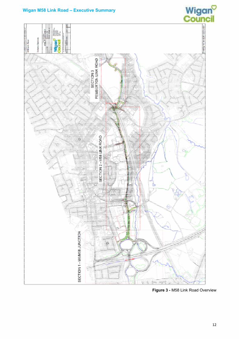
4.1 The proposed M58 LR consists of a 2.3km, 30mph single carriageway connecting Junction
6 of the M58 & Junction 26 of the M6 to the southern part of Wigan Town Centre, via the A49 at Smithy Brook (see Figure 3).
4.2 The link road will provide a new high-profile gateway into Wigan town centre from the M58/M6, linking the Lamberhead Industrial Estate, the Pemberton Colliery site and the new Westwood Park employment site to the strategic highway network. The scheme includes improvements at junction 26 of the M6, which will accommodate the change in traffic flows and impact on the strategic route network (SRN) once the link road is constructed.
4.3 The M58 link will create a completely new road from junction 26 of the M6, crossing Brook Lane and connecting onto the western end of Leopold Street. Leopold Street itself will be widened along its southern side, and a new section of road constructed near to the eastern end of Leopold Street connecting through to Billinge Road. A new traffic signalled controlled junction will be constructed at Billinge Road / Pemberton Bridge with the new road continuing eastwards connecting to Smithy Brook Road.
Wigan M58 Link Road – Executive Summary
12
Figure 3 - M58 Link Road Overview
Wigan M58 Link Road – Executive Summary
13
4.4 A new shared use path along its entire length will provide enhanced sustainable transport connections for local trips between communities and to the town centre. The connection to the new A49 link road will provide a continuation with sustainable travel links to the local facilities along the Poolstock corridor, the canal towpath, Wigan Flashes and interfaces with the proposed Cycle City Ambition Grant 2 (CCAG2) funded works.
4.5 The M58 LR scheme is split into three sections: 4.5.1 Section 1 – Upgrade of existing M6 junction 26
Upgrade works are required to the two roundabouts under the M6 to mitigate the effects of the proposed M58 LR on the SRN. The works proposed will include:
• Full signalisation of the eastern roundabout
• Additional lane gain at critical points
• Flare length extension on southbound slip entry approach
• Construction of a new arm on the eastern roundabout to provide access for the proposed M58 Link Road.
The current eastern motorway roundabout junction (M6 J26) and slip road to the A577 Orrell Road is to be de-specialised to allow all vehicle classifications the ability to negotiate.
4.5.2 Section 2 – Construction of a new link road from the M6 junction 26 to Billinge Road
These works proposed will include:
• Creation of new road across land currently used for ad-hoc grazing
• Widening along the southern side of Leopold Street (existing carriageway)
• Widening works and bridge parapets at Network Rail’s Pemberton structure on Billinge Road
• Introduction of pedestrian and cycling facilities
• Installation of controlled pedestrian crossing facilities 4.5.3 Section 3 – Construction of a link road through the Pemberton Colliery development
site, connecting Billinge Road to Smithy Brook Road These works proposed will include creation of new road across brownfield land, introduction of pedestrian and cycling facilities, and installation of controlled pedestrian crossing facilities. Given that the Pemberton Colliery site is privately owned and outline planning permission has been granted for the wider development of the site, it is anticipated that Section 3 of the link road will be delivered and funded by the developer.
4.6 Employment and Housing
4.6.1 The enhanced strategic links between the motorway and the Town Centre are expected to
bring forward wider investment and job opportunities, in particular in the Town Centre and sites adjacent to the Town Centre such as the Wigan Pier Quarter and the aforementioned Pemberton Colliery, Lamberhead Industrial Estate and Westwood Park. The new link road will significantly improve accessibility into central areas, making the area more attractive as a place to invest and create new jobs whilst also enhancing access to job opportunities for local people.
4.6.2 The M58 LR complements the redevelopment of the Pemberton Colliery site due to direct links to the M6 and M58 motorway network. The Pemberton Colliery site is a proposed mixed use development opportunity with planning approval for employment and residential land use. Phase 1 of the developments’ link road has already been constructed (Smithy Brook Road) providing a direct access to the site from the A49, which will connect the M58 LR and A49 LR, linking directly with Wigan Town Centre. The existing employment site at Pemberton Colliery will also benefit from the enhanced connectivity.
Wigan M58 Link Road – Executive Summary
14
4.7 Sustainable Transport and Leisure 4.7.1 The M58 LR incorporates a shared use footpath and cycleway along its length, providing
enhanced sustainable transport connections for local trips between communities and to the town centre, and sustainable travel links to the wider cycle network including connections with the canal towpath and Wigan Flashes (via the A49 Link Road) and eastwards through Greenheart which connects to Haigh Country Park in the north of the Borough through to Leigh Sports Village in the south.
4.7.2 The M58 LR will enhance opportunities for leisure for the local area, improving direct links, via the A49 LR, to the Wigan Flashes, which is a site of national wildlife significance, designated a Site of Special Scientific Interest (SSSI). Outline planning permission for a visitor centre has been granted as part of the outline approval for Westwood Park. The Wigan Flashes is a key site in the Carbon Landscape Project, a £3.2 million programme funded through the Heritage Lottery LWT and their partners. This programme will enhance and connect up the restoration of the Wigan Flashes landscape, altered by industry, creating and improving this nationally significant habitat, and reconnecting local people with the heritage and wealth of opportunities for enjoyment and learning on their doorstep.
4.7.3 The proposed M58 LR will cross an existing rugby pitch at Orrell St James sport ground.
The scheme will replace the pitch on a like for like basis to ensure there is no detriment to the club and that the proposals are in line with the Council’s playing pitch strategy.
STRATEGIC CASE
1. Problems and Issues < Opportunities / drivers for change
1.1 The three strands of the three main scheme objectives:
• Enhanced Connectivity;
• Reduced Congestion; and
• Economic Growth.
2. Enhancing Connectivity
2.1 Accessibility and connectivity, in particular to strategic networks, is a key factor for economic growth and attracting investment. Although strategically located at the heart of the North West’s road and rail transport networks there is a perception that Wigan is less well regarded as a location to do business due to access constraints. This factor has significance both in terms of attracting investment and for the performance of businesses located in the Borough.
2.2 Following consultation with key economic stakeholders, successive consultancy reports on behalf of the Council (B2B) in 2002, 2007 and 2010 have reinforced the view that poor highway access is one of the key factors hindering investment in the borough. A 2010 study by GVA also highlighted that in terms of employment land Wigan has a “supply constrained demand”. This issue is particularly pertinent to the west of Wigan where despite proximity to the M6, access to the motorway and also into the town centre weakens the case for investment.
2.3 The Council has recently delivered improvements to the Saddle junction including a new link road between Wallgate / Pottery Road and the Saddle junction (previously one of the worst congestion areas in the borough). This successful scheme provides enhanced connections to the town centre from the west, but does not provide the wider accessibility and connectivity improvements to the motorway network required to unlock opportunities for economic growth and development at Pemberton Business Park and areas to the east of the town.
Wigan M58 Link Road – Executive Summary
15
2.4 The M58 Link Road and subsequent connection through to Pemberton Colliery will provide a much-needed catalyst to bring about the development of the site, by improving accessibility and investment potential.
2.5 The combination of the M58 Link Road and the A49 Link Road as well as the already constructed Saddle Relief Scheme will substantially assist in bringing forward new employment opportunities whist protecting and enhancing existing sites such as Lamberhead Industrial Estate.
3.0 Environmental Issues – Congestion
3.1 Congestion
3.1.1 The A577 Ormskirk Road is a highly-congested local road with a large number of side roads accessing onto the route which was not designed to cater for the level of traffic currently using it. It provides a particularly poor connection for freight wishing to access the motorways, but for which there is currently no other viable option. The result is significant amounts of congestion along the route which impacts adversely on the quality of the environment for the local residents.
3.1.2 The A577 passes through Pemberton Shopping Centre, which is a vibrant local facility with many shops and services provided to local people. The congestion and number of goods vehicles in particular can on occasions be detrimental to shoppers and visitors to the local centre. The removal of some through traffic will make Pemberton centre a better place for shoppers, increasing the viability and vitality of the centre.
3.1.3 The A577 also passes through a number of residential areas. The congestion issues along the A577 corridor can on occasions impact on bus journey reliability, to the detriment of bus passengers and local residents. The reduction of through traffic will assist bus services in maintaining timetables.
3.1.4 A congestion study undertaken in 2010 identified the worst congestion hotspots in the borough with the A577 Ormskirk Road Orrell Post junction being one of the worst (GMTU Wigan Congestion Study Sept 2010, Report 1579).
3.1.5 Traffic approaching the Orrell Post junction is recorded to have some of the lowest morning and evening peak period speeds of less than 10mph. In contrast general average speeds in the morning peak on the roads around the centre of Wigan and those approaching from Aspull, Ince-in-Makerfield and Worsley Mesnes are between 15 and 30mph.
3.1.6 The relatively low capacity in relation to traffic volumes, allied with terraced residential frontages and local amenities and number of side roads, results in peak and some off peak congestion and queuing. As a major route for traffic accessing the Town Centre from the west of the Borough and the M6, congestion issues that are currently present act as a constraint to Wigan Town Centre access and increase journey times. Interventions to alleviate congestions on the A577 within the remit of the existing infrastructure have been assessed, however this is limited to Traffic Regulation Orders to ban on street parking to assist flow and traffic signal software updates and is not therefore considered to provide the required level of impact.
3.2 Environmental Issues - Air Quality
3.2.1 The A577 suffers a number of air quality issues associated with the congestion problems, and lies within an Air Quality Management Zone.
Wigan M58 Link Road – Executive Summary
16
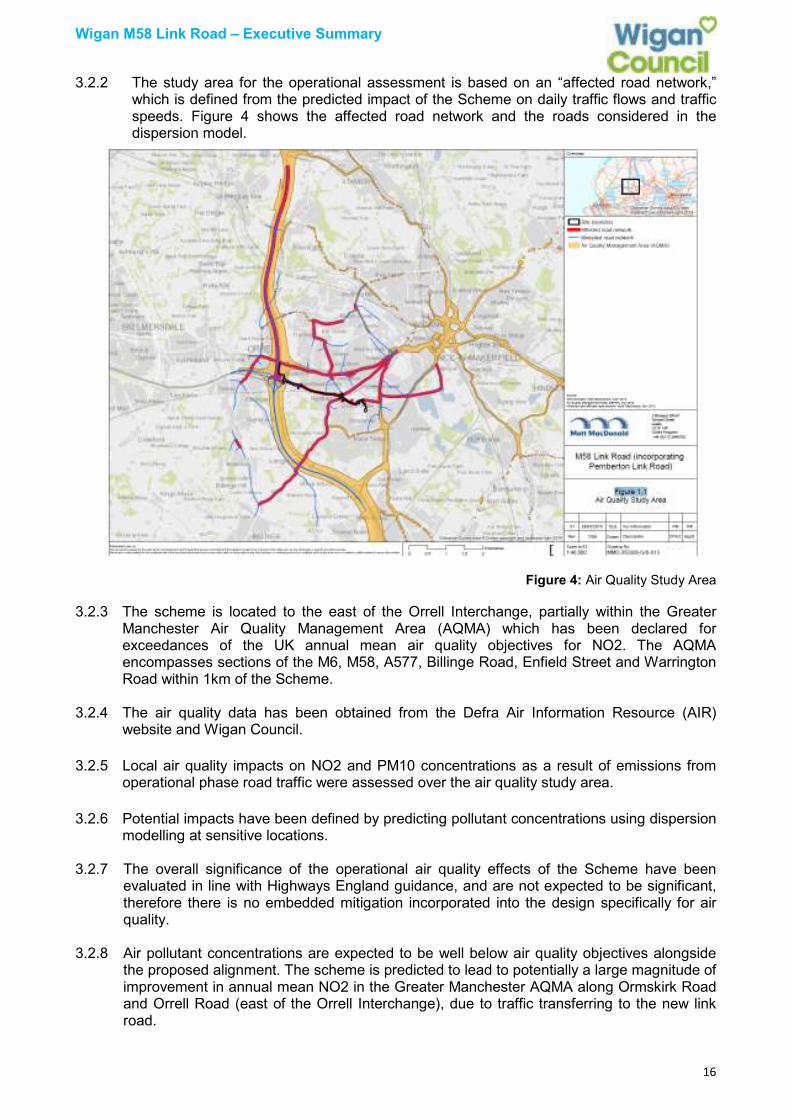
3.2.2 The study area for the operational assessment is based on an “affected road network,” which is defined from the predicted impact of the Scheme on daily traffic flows and traffic speeds. Figure 4 shows the affected road network and the roads considered in the dispersion model.
Figure 4: Air Quality Study Area
3.2.3 The scheme is located to the east of the Orrell Interchange, partially within the Greater Manchester Air Quality Management Area (AQMA) which has been declared for exceedances of the UK annual mean air quality objectives for NO2. The AQMA encompasses sections of the M6, M58, A577, Billinge Road, Enfield Street and Warrington Road within 1km of the Scheme.
3.2.4 The air quality data has been obtained from the Defra Air Information Resource (AIR)
website and Wigan Council.
3.2.5 Local air quality impacts on NO2 and PM10 concentrations as a result of emissions from operational phase road traffic were assessed over the air quality study area.
3.2.6 Potential impacts have been defined by predicting pollutant concentrations using dispersion modelling at sensitive locations.
3.2.7 The overall significance of the operational air quality effects of the Scheme have been evaluated in line with Highways England guidance, and are not expected to be significant, therefore there is no embedded mitigation incorporated into the design specifically for air quality.
3.2.8 Air pollutant concentrations are expected to be well below air quality objectives alongside the proposed alignment. The scheme is predicted to lead to potentially a large magnitude of improvement in annual mean NO2 in the Greater Manchester AQMA along Ormskirk Road and Orrell Road (east of the Orrell Interchange), due to traffic transferring to the new link road.

Wigan M58 Link Road – Executive Summary
17
3.2.9 A small improvement in annual mean NO2 is also predicted in the AQMA along Billinge Road due to a reduction in traffic flow, however a small deterioration in annual mean NO2 is predicted at receptors adjacent to the Scheme alignment due to the introduction of a new source of traffic pollution. This is to be expected and the scheme is not expected to lead to any exceedance of air quality objectives.
3.2.10 Cycling facilities have already been provided along part of the A577 corridor, between Ridyard Street and Wigan Town Centre providing a two way, traffic free cycle facility. This scheme was funded from the Cycle Safety Fund (CSF), given the number of cycle casualties and connections between areas of deprivation, employment, education and health facilities.
3.2.11 Cycling along the remaining Ormskirk Road is not an enjoyable experience and this could discourage cycling from the residential areas of Pemberton, Lamberhead Green and Norley Hall, which are within easy cycling distance of the wider Wigan town centre area. The Council has been successful in gaining Cycle City Ambition Grant (CCAG 2) funding, through TfGM, which will be used to extend the existing CSF scheme towards Pemberton. The long term goal is to provide improved cycling facilities between Pemberton and Wigan Town Centre, therefore the M58 LR scheme will also provide a continuous shared-footway scheme to encourage modal shift and cycling/pedestrian connectivity. Improved pedestrian accessibility, cycle conditions and bus journeys and an enhanced waiting environment will also encourage modal shift.
3.3 Road Safety
3.3.1 Road accidents have been shown to impose significant costs upon the economy and result
in significant social problems. (Towards 2020 Greater Manchester Plan for Road Safety). Financial implications can be as a result of damage to property, increased insurance cost, lost output due to injuries and costs against public services.
3.3.2 Accident data has been collated from TfGM’s accident database and STATS 19 (a national database of accidents). This data highlights the quantum and nature of accidents observed within the extents of the study area and provides narrative on the likely impact of the proposed scheme in qualitative terms. A high level qualitative assessment of the safety implications of the scheme has been carried out.
Impact of the M58 Link Road
3.3.3 The M58 LR proposals will provide an alternative route between the M6 and Wigan Town
Centre diverting traffic off the A577. Therefore traffic levels on the M58 LR (formerly Leopold Street) and the A571 Billinge Road will increase compared with existing volumes. Whilst this could increase the risk of collisions, the design of the M58 LR incorporates a number of measures to mitigate this risk including the widening and extension of Leopold Street to ensure very good forward visibility for all modes along the M58 LR and a wide central refuge to provide adequate provision for large HGV traffic completing right turns into the industrial units - thereby reducing the potential for conflicts between vehicles along the Link Road.
3.3.4 The proposed pedestrian crossing facilities along the M58 LR will ensure pedestrians can
cross at a number of convenient locations using both controlled and uncontrolled facilities adjacent to existing Public Right of Way (PRoW) / existing junctions / pedestrian desire lines reducing potential conflicts between pedestrians, cyclists and vehicles.

Wigan M58 Link Road – Executive Summary
18
3.3.5 Given the M58 LR proposals will provide an improved route for vehicles with high quality junction designs and pedestrian facilities, a reduction in traffic along the A577 is expected, potentially reducing the possibility of conflict between different modes of travel (particularly between journeys on foot and motor vehicles). It is therefore considered that the M58 Link Road proposals will not materially impact on highway safety but may offer improvements along the A577.
3.3.6 The wider route connecting between the A571 and the A49 will experience an increase in
traffic volumes on Smithy Brook and the A49. To mitigate the risk of potential accidents along this route, recent upgrades to the signalised junction of the A49 / Smithy Brook ensure that conflicts between vehicles and pedestrians are kept to a minimum as pedestrian facilities are of an excellent quality. Furthermore, forward visibility is excellent on all approaches which will reduce the risk of rear end collisions, normally linked to an increase in traffic at signalised junctions.
3.3.7 The recently installed roundabout of the A49 / proposed A49 Link Road / housing
development also benefits from excellent pedestrian and cycling facilities. The roundabout benefits from excellent visibility and the provision of a bypass lane travelling northbound from the A49 ensures the potential for future conflicts between different modes of travel is kept to a minimum.
3.3.8 In conclusion, the new M58 link road will improve accessibility and reduce congestion on
and around the A577 and will make a significant difference to the environment and quality of life in that area and allow further environmental improvements to be made to the A577 corridor. Bus journey times will be improved along with pedestrian and cycling conditions. Access to Pemberton Shopping Centre will be also improved boosting its turnover and overall shopping offer. The M58 LR scheme will also improve routes for sustainable modes of travel, encouraging modal shift, improving air quality and removing the existing community severance along the A577 corridor.
4 Supporting economic development and growth
4.1 By 2035, Greater Manchester aims to be one of the leading sub regions, driving sustainable
growth across the North of England. Using Wigan’s unique position, located between Manchester and Liverpool, increasing and improving the transport networks is key to driving forward sustainable growth. By increasing the economic growth and prosperity within the borough, this will ensure that all who live in the borough are able to take maximum advantage of the employment opportunities in both Wigan and the surrounding areas, increasing the quality of life for the residents in the borough.
4.2 There are major plans in place for a number of developments in and around Wigan Town Centre, and both the M58 and the A49 link will add significant value in helping to deliver these proposals whilst also helping to maintain the current significant footfall and the low retail vacancy rates. Businesses have recently moved into the borough because of the excellent connectivity to the M6. Developments such as Wigan Pier Quarter and the former Pemberton Colliery site will benefit from a direct link by the M58 link road and will assist these developments to move forward quicker. By continuing to improve our network and the connectivity to the major motorway networks, it will be an incentive to new businesses looking to relocate into the borough.
4.3 Pemberton Business Centre is situated on the outskirts of Wigan, less than one mile away
from Junction 26 of the M6. The Centre is a well-established, commercial location and offers accommodation for business start-ups. Also around this area is Lamberhead Industrial Estate, another thriving centre for local businesses who will benefit from the increased connectivity in the area. The delivery of the M58 link road will contribute significantly to the delivery of the remaining areas at Pemberton as well as allowing new Inward Investment opportunities for businesses looking to relocate to the borough.

Wigan M58 Link Road – Executive Summary
19
4.4 The former Pemberton Colliery site, a key strategic employment site with planning
permission forms part of a 33 acre area of land which was a former open cast mining site and is located off Smithy Brook Road, South of Wigan Town Centre. In 2008, a third party applied for planning consent for a mixed use redevelopment scheme comprising of class B1, B2 and B8 employment uses, residential (Class C3) live/work units, a neighbourhood centre (Classes A1, A2, A3,A4 and A5), a hotel (Class C1) and associated works. This scheme was approved subject to conditions in 2011. The new link road is required to support the strategic highway access to the site, support the provision of new homes as well as providing enhanced connections to Wigan town centre and areas such as the Wigan Pier Quarter. The link road also makes this site and those sites adjacent much more attractive to sector specific investors, developers and businesses with a direct link to the Liverpool Ports.
4.5 The M58 LR will improve accessibility between the motorway network and a number of key employment sites. Businesses reliant on transport connections to the rest of the country need good access to the motorway, with employers wanting a wide labour marker. The reduced congestion levels afforded by the M58 LR will open up key employment sites to the wider labour market both locally and those from further afield.
Wigan Council’s Employment Skills Strategy 2014-17
4.6 Wigan Council’s Employment Skills Strategy 2014-17 is part of the Council’s overarching
programme to provide self-reliance and reduce dependency on public service provision. Work and skills have been identified as a cross cutting theme in supporting people to develop independence by raising skills and aspirations, and ultimately finding work, the Employment Skills Strategy sets out the aspiration. The role that the M58 link plays is complementary to this in that this strategy looks at the skills side whilst the M58 deals with the connectivity and those seeking job opportunities being able to access these jobs much easier.
Employment Summary
4.7 Wigan has experienced one of the lowest percentage reductions in unemployment in the
region over the last 12 months, however is noted that the actual reductions place Wigan in the top 5 Greater Manchester Authorities with a reduction of 225 unemployed. Wigan is one of the worst performing local authority areas in the North West in terms of business start-up rates and significantly below the UK average. It is evident however those businesses choosing to start up in the Wigan Borough have a higher chance of success, as Wigan has the lowest ranked business closure rate. There is a continuous, high demand for incubator/start-up units and managed workspace for the entrepreneurial sector.
ECONOMIC CASE
1.1 The M58 scheme has been shown to represent “Very High” overall Value for Money, which is increased further when other infrastructure elements of the transport strategy, including the A49 link road and the completed Marus Bridge Pinch Point Scheme, are also taken into account.
1.2 The Value for Money Statement below summarises the performance of the scheme against each assessment category.
Value for Money Statement
Monetised
Benefits
Time savings on the highway network were estimated from the Wigan Saturn model.
Savings comprise 90% of monetised benefits, with 75% of benefits in the peak hours of the
day.
Wigan M58 Link Road – Executive Summary
20
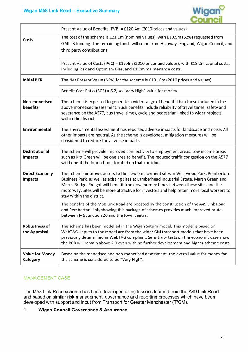
Present Value of Benefits (PVB) = £120.4m (2010 prices and values)
Costs The cost of the scheme is £21.1m (nominal values), with £10.9m (52%) requested from
GMLTB funding. The remaining funds will come from Highways England, Wigan Council, and
third party contributions.
Present Value of Costs (PVC) = £19.4m (2010 prices and values), with £18.2m capital costs,
including Risk and Optimism Bias, and £1.2m maintenance costs.
Initial BCR The Net Present Value (NPV) for the scheme is £101.0m (2010 prices and values).
Benefit Cost Ratio (BCR) = 6.2, so “Very High” value for money.
Non-monetised
benefits
The scheme is expected to generate a wider range of benefits than those included in the
above monetised assessment. Such benefits include reliability of travel times, safety and
severance on the A577, bus travel times, cycle and pedestrian linked to wider projects
within the district.
Environmental The environmental assessment has reported adverse impacts for landscape and noise. All
other impacts are neutral. As the scheme is developed, mitigation measures will be
considered to reduce the adverse impacts.
Distributional
Impacts
The scheme will provide improved connectivity to employment areas. Low income areas
such as Kitt Green will be one area to benefit. The reduced traffic congestion on the A577
will benefit the four schools located on that corridor.
Direct Economy
Impacts
The scheme improves access to the new employment sites in Westwood Park, Pemberton
Business Park, as well as existing sites at Lamberhead Industrial Estate, Marsh Green and
Marus Bridge. Freight will benefit from low journey times between these sites and the
motorway. Sites will be more attractive for investors and help retain more local workers to
stay within the district.
The benefits of the M58 Link Road are boosted by the construction of the A49 Link Road
and Pemberton Link, showing this package of schemes provides much improved route
between M6 Junction 26 and the town centre.
Robustness of
the Appraisal
The scheme has been modelled in the Wigan Saturn model. This model is based on
WebTAG. Inputs to the model are from the wider GM transport models that have been
previously determined as WebTAG compliant. Sensitivity tests on the economic case show
the BCR will remain above 2.0 even with no further development and higher scheme costs.
Value for Money
Category
Based on the monetised and non-monetised assessment, the overall value for money for
the scheme is considered to be “Very High”.
MANAGEMENT CASE
The M58 Link Road scheme has been developed using lessons learned from the A49 Link Road, and based on similar risk management, governance and reporting processes which have been developed with support and input from Transport for Greater Manchester (TfGM).
1. Wigan Council Governance & Assurance
Wigan M58 Link Road – Executive Summary
21
1.1 All contracts procured and delivered by Wigan Council, including any project changes, are governed by the Council’s standard Financial Procedure Rules and Procurement Strategy, which are available on the Council’s website:
• https://wigan.gov.uk/Council/Performance-and-Spending/Financial-Procedure-Rules.aspx;
• https://wigan.gov.uk/Business/Council-Procurement/procurementstrategy.aspx.
1.2 Within Wigan Council the M58 Link Road falls within the remit of the Council’s Economy
Board, chaired by the Council’s Portfolio Holder for Economic Development & Regeneration.
2 Scheme Delivery
2.1 Delivery of the scheme will be overseen by the Council’s Major Projects & Regeneration team, with specialist support provided by TfGM (project management, risk management, scheduling, commercial) and external advisers.
3 GMCA & TfGM Governance & Assurance
3.1 All district-delivered Growth Deal Major Projects are governed and assured by with the Greater Manchester Combined Authority (GMCA).
4 Programme of Scheme Delivery
4.1 Currently the scheme is expected to start construction end of 2019 with completion end of 2020, subject to securing all necessary agreements and approvals.
5 Risk Management
5.1 Wigan is working in collaboration with TfGM and has adopted TfGM’s comprehensive Risk Management Policy and Strategy which is widely adhered to throughout the organisation and Greater Manchester wide. This provides assurance that the necessary controls are in place for active decision-making, management and delivery.
6 Health and Safety
6.1 The council will ensure that all health and safety requirements are in place and monitored in accordance with the Council’s corporate reporting procedures.
7 Powers and Consents
7.1 Work has been undertaken to identify the permissions and approvals required to progress and complete the scheme. These include planning, land acquisition and legal agreements between external stakeholders with specific references to a Compulsory Purchase Order, a Side Road Order (SRO), De-specialisation, Traffic Regulation Orders (TRO’s), Road Classification and Public Right of Way.
7.2 The Council will also provide the relevant reports for approval in order to obtain the appropriate level of authority in accordance with the Council’s Constitution.
8 Planning Approval
8.1 On 8 September 2017 Wigan Council submitted a planning application seeking approval for the alignment of the road, granting the powers to commence construction. It is expected that the scheme will be presented for consideration by the Council’s Planning Committee in

Wigan M58 Link Road – Executive Summary
22
early 2018. Planning Documents are available via the following link quoting reference A/17/84615 https://apps.wigan.gov.uk/planapps/
9 Stakeholder Management
9.1 Detailed community engagement has been undertaken on a number of occasions as the scheme has progressed.
9.2 Questionnaires and consultation drop-in events were undertaken in December 2015 and December 2016 to allow residents and businesses the opportunity to input and pass comment, which has helped to shape the scheme. The improvements outlined below have been forthcoming from comments raised at public consultation, incorporated to enhance the scheme. These are also captured in the change log below.
Design change Reason
New toucan crossing proposed on Leopold
Street to facilitate pedestrian movements
between Merton Road and Smethurst Lane via
the existing railway footbridge.
To promote connectivity and assist sustainable
transport, offering improved routes to school on
pedestrian desire lines.
Proposed toucan crossing at the junction of
Brook Lane and Leopold Street.
To facilitate pedestrian movements on the
desire line from the existing Public Right of Way.
Realignment of Brook Lane with pedestrian
island and right turn pockets added on the M58
Link Road.
The realignment reduces environmental impact
on Brook Lane, retaining trees that would've
been affected. The pedestrian island assists
two-stage crossing on the link road for
pedestrians and cyclists wishing to access
Brook Lane, whilst the right turn pockets give
protection to vehicles waiting to turn.
Enfield Street to remain open with one-way
traffic flow away from its junction with Leopold
Street (northwest bound).
To reduce journey times, providing a more direct route to destinations.
Foundry Lane, at its junction with Billinge Road
is to remain open, with left turn only for traffic.
To reduce journey times, providing a more direct
route to destinations, avoiding the traffic signals.
Cycle/pedestrian facility on the slip road
connecting Orrell Road to the motorway junction
has been removed from the proposals. An
alternative route has been identified connecting
Milton Grove to Shelley Drive.
The alternative route provides improved value
for money, with reduced impacts on the
surrounding environment, reducing engineering
works, whilst providing improved facilities for
pedestrians and cyclists.
Proposed connecting road between the link road and Foundry Lane has been moved away from designated public open space.
To maintain aesthetics and public open space.
9.3 During the design and delivery phase of the M58 LR regular communications will be made with ward members, the public and business community to ensure that they are fully aware of the benefits of the scheme, but particularly at those times when there will be the potential for increased traffic delay and travel disruption during construction.
9.4 Regular members’ briefings are held at key project milestones with those wards that are directly affected by the scheme. This gives an opportunity to dispel myths, give reassurance and allow questions to be asked directly to the project team.
Wigan M58 Link Road – Executive Summary
23
9.5 Wigan Council’s Media and Communications Team is involved at every stage along the process to actively promote the scheme via social media platforms including Facebook and Twitter. The Council’s webpages (https://www.wigan.gov.uk/Resident/Parking-Roads-Travel/Roads/Road-schemes.aspx) are updated regularly as important milestones are met to keep the public informed. The website features links to the planning portal to allow all associated planning documentation to be viewed, along with a matrix of frequently asked questions to reduced officer correspondence. Residents are kept informed via letters and press releases. A mailing list has been established for those residents that wish to receive regular newsletter updates from the project team as milestones are met.
9.6 The Council is committed to maximising the social value opportunities provided by the scheme, in line with both the Council’s “Deal” and the GMCA Social Value Policy, and it is our intention to embed this in procurement and delivery processes.
10 Monitoring and Evaluation
10.1 The scheme will be subject to a programme of before and after monitoring and evaluation. This will demonstrate the extent to which the three key scheme objectives have been met:
• Enhanced Connectivity;
• Reduced Congestion; and
• Economic Growth.
10.2 Given the close strategic and physical inter-relationship between the M58LR and the A49LR, a combined monitoring and evaluation approach will be adopted to take account of the cumulative benefits derived to provide a cohesive and cost effective output. This will reinforce the underlying logic behind both schemes, enabling the use of common data sources.
FINANCIAL AND COMMERCIAL CASE
1. Financial Summary
1.1 It is intended that the scheme (Sections 1 and 2) will be designed together and the full
scope will be developed in the next phase of the scheme.
1.2 The M58 LR will be designed and built to a standard that is acceptable for adoption by Wigan Council and the Council has confirmed that it will make provision within its revenue budgets to operate and maintain the new highway. This includes renewal costs. These costs have not been included as part of the funding applications as they will become part of the maintenance and operation costs for the highway authority’s normal maintenance budget.
1.3 For traffic signals, maintenance liabilities are set out in the Council Constitution dated May 2016 pages 133-135. As a district led scheme future maintenance liabilities for the traffic signals will be paid by the GMCA (this is managed by TfGM as part of an existing maintenance contract). TfGM will specify and approve all traffic signal works. Future maintenance of the Highways England traffic signals currently rest with HE.
1.4 TfGM has carried out a high level review of the scheme costs, and benchmarked this against other schemes.
Wigan M58 Link Road – Executive Summary
24
2. Section 151 Officer Sign off 2.1 The Council has confirmed its commitment to bridging any funding gap identified to secure
full delivery of the scheme. This will be achieved through a combination of identifying funding contributions and robust cost management.
3. Payments Schedule 3.1 All Growth Deal monies will be held centrally by GMCA.
3.2 Upon the achievement of Conditional / Full Approval by individual schemes, payment will be
made for all eligible capital costs incurred to date by Wigan Council in their role as scheme promoter. Thereafter, subsequent payments will be made by GMCA as per a Delivery Agreement to be agreed between Wigan Council, TfGM and the GMCA.
4. Funding Conditions 4.1 Grant funding will be provided under Section 31 of the Local Government Act 2003 and will
be subject to the standard terms and Growth Deal Majors governance arrangements. Detailed grant conditions will be captured within a Delivery Agreement between the Council, TfGM and GMCA. The Growth Deal programme has allocated £10.9 million to the M58 LR, along with £5 million from Highways England’s Growth and Housing Fund.
5. Procurement Strategy
5.1 Due to the scheme not currently being fully defined in terms of scope and timescales, the appetite and capacity for the scheme cannot yet be ascertained. It is therefore considered prudent at this stage to assume that a standalone OJEU-compliant tender process will be followed, however this will be subject to ongoing review and market testing prior to progression of tender documentation. Any alternative approach, for example via an available framework, would take into account the benefits in terms of programme and constraints of the basis for the framework procurement.
5.2 The NEC3 contract suite is recommended by Government for this type of scheme with Priced Contract with Activity Schedule (lump sum) (Option A) or Target Contract with Activity Schedule (Option C) considered options. Wigan Council will consider the advantages and disadvantages in deciding the preferred option.
Advance Works
5.3 In order to attempt to mitigate risks associated with the delivery of the scheme advance works will be considered.
Risk, Transfer and Mitigation
5.4 It is expected that risks will be transferred to the contractor as much as possible to limit Wigan Council’s exposure.