what is groundwater?. la’s water resources you may be familiar with spring water…
TRANSCRIPT

What is Groundwater?
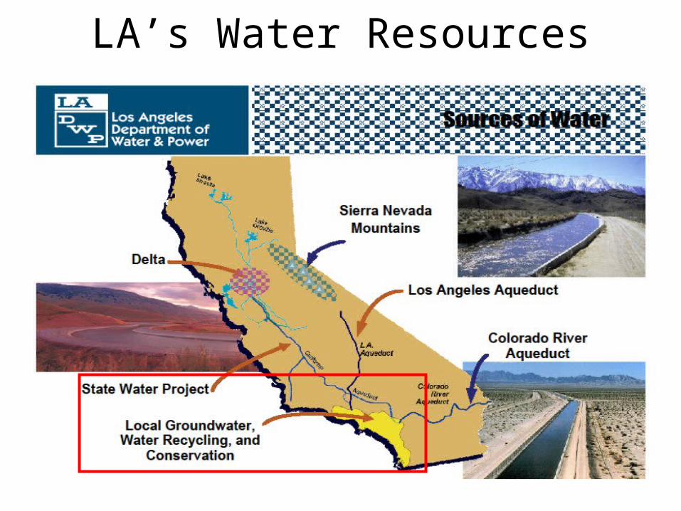
LA’s Water Resources
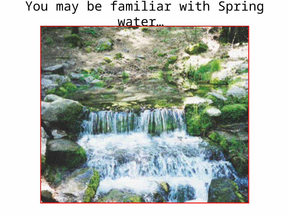
You may be familiar with Spring water…

Aquifer:A water-bearing rock that readily transmits
water to wells and springs
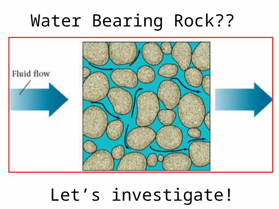
Water Bearing Rock??
Let’s investigate!
notes
Slide 1:
• Groundwater is water that is stored underground.
• It is recharged when rain soaks into the ground.
• We can access this water by drilling a well to pump it out. This is a renewable resource (as long as it is not pumped out much faster than it can be recharged).
Slide2:
Los Angeles actually gets 11% of it’s water from the ground, and the one of the city’s goals for the future is to use less imported water and more groundwater.
Slide 3:
• This is a picture of a spring. Springs are where water is comes out of the ground at the earth’s surface. Arrowhead water is an example of spring water (bring in bottle as ex.).
Slide 4:
• How is water stored underground?
• A common misconception is that groundwater is stored in underground lakes. It is actually stored in layers of rock called aquifers.
• Imagine that you took the sand that you found at the beach and put it under pressure for a long time. Eventually, you would end up with sandstone. Just like there is a tiny bit of space between individual grains of sand, there is a tiny bit of space between grains in sandstone. Water can be stored in and move through this space. Because underground rock layers can be very big, they can actually store a lot of water.
Slide 5:
• Here is what that would look like…
• Now we are going to do an experiment to demonstrate this concept

Additional slides & notes from the presentation I modified for this lessonwww.elmhurst.edu/~richs/EC/102/Lectures/Groundwater.ppt

Groundwater Depletion
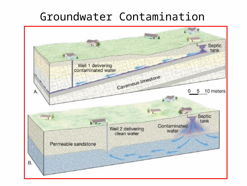
Groundwater Contamination
Groundwater Groundwater is water, which originates from the infiltration of fluids
through the soil profile and accumulates below the earth's surface in a porous layer.
Porosity is the percentage of open void space in the subsurface material.
It is expressed as a percent. Permeability is how readily a fluid can flow through a material. Often
referred to as "connected pore space". Pieziometric surface is the surface in which water is pushed up to by
the pressure below. Spring is where water flows out without the aid of pumping. It may be
caused by hydrostatic pressure (pressure pushing upward), or the intersection of the pieziometric surface with the ground surface. Also referred to as an Artesian System.
An aquifer is the porous unit or layer of rock that is able to store or hold
water and transmit enough fluid to be of economic value. An aquitard is rock material that is low in porosity/permeability. Fluid
flow is not good and the unit may often be termed a "cap rock", not allowing underlying water to flow upward.
An aquiclude is a unit of rock or layer of rock, which is impermeable to
fluids. It acts as a barrier to fluid flow. There probably are no true aquicludes.
There are two (2) scenarios that may occur with aquifers:1. Confined Aquifer -- when an aquifer is bounded by two (2) aquitards
(one above and one below)2. Unconfined Aquifer -- when an aquifer is not bounded on the surface
side by an aquitard so that fluids may flow freely above the aquifer. The distribution of groundwater is present in several distinct layers or
zones:a. Soil moisture zone -- usually top soil; much infiltration; much organic
materialb. Zone of aeration (Vadose Zone) -- mostly air but some interstitial
waterc. Capillary fringe -- transition between unsaturated and saturated
zone; top of aquiferd. Zone of saturation (Phreatic Zone) -- pores completely saturated with
water; main aquifer storage zone Where does water in the ground originate?Hydrologic Cycle explains the origin of groundwater.Depicts the occurrence and movement of water in the earth-atmosphere
system. Water enters the GW system at recharge areas. Water leaves GW system at discharge areas. Occurrence of water1. 97% of all water on earth is in oceans. 2. ~ 2% of the earth's water in ice caps & glaciers 3. About 0.6% of earth's water is groundwater4. Water in rivers, lakes, and the atmosphere amounts to less than
0.02% of earth's water Movement of WaterAtmosphere to surface: precipitation Surface to atmosphere: evaporation -- liquid to vapor Sublimation -- solid to vapor Transpiration -- release of water vapor by plants On surface: downslope movement to lakes, streams, and oceans Below surface: movement of groundwater If GW seeps into stream, stream is a gaining stream. If water seeps from stream into subsurface, it is a losing stream. In areas in which soluble rock (i.e., limestone) is present in the layer near
the groundwater, a situation often develops that is characterized by rock layer dissolving. This is referred to as karst topography.
Indiana, Kentucky, and Georgia are areas in which karst topography may
develop. The area is characterized by:a. Soluble bedrock near the surfaceb. Disappearing streams that feed downward with no end on the surfacec. Sinkholesd. Patchy, pockmarked surface topographye. Frequent fluctuations in water tablef. Cavesg. Submerged caves Caves are formed by the dissolving nature of the rock fed by groundwater.
Large cavities develop as well as solid drops of rock that precipitate from the groundwater solution.
Those overhead are called stalactites (stick tight to the ceiling) and those that build up from the ground floor are termed stalagmites (with a ''g'').
There are several problems, which can develop, associated with the
lowering of the groundwater surface due to overuse/over pumping:1. Cone of depression develops2. Lowering of the pieziometric surface, thus wells dry up3. Saltwater incursion/intrusion if near an ocean Groundwater ContaminationContamination results in a decline in water quality. Common contaminants: Types Sources Nitrates Sewage, Fertilizers, Feedlots Pesticides, herbicides Agriculture, lawn care Organic chemicals Industrial wastes, landfills, spills/leaks of
fuels Metals Industrial processes Brines Oil production Protecting groundwater resourcesApply agricultural chemicals properly Build better landfills Regulate disposal of hazardous materials Regulate underground storage tanks (USTs)Limit contaminant levels in drinking water supplies. Companies often employ environmental consulting firms and individuals
to better understand environmental problems and seek solutions for the challenges.
An aquiclude is a unit of rock or layer of rock, which is impermeable to fluids. It acts as a barrier to fluid flow. There probably are no true aquicludes.
There are two (2) scenarios that may occur with aquifers:1. Confined Aquifer -- when an aquifer is bounded by two (2)
aquitards (one above and one below)2. Unconfined Aquifer -- when an aquifer is not bounded on the
surface side by an aquitard so that fluids may flow freely above the aquifer.
The distribution of groundwater is present in several distinct layers or
zones:a. Soil moisture zone -- usually top soil; much infiltration; much organic
materialb. Zone of aeration (Vadose Zone) -- mostly air but some interstitial
waterc. Capillary fringe -- transition between unsaturated and saturated
zone; top of aquiferd. Zone of saturation (Phreatic Zone) -- pores completely saturated with
water; main aquifer storage zone Where does water in the ground originate?Hydrologic Cycle explains the origin of groundwater.Depicts the occurrence and movement of water in the earth-atmosphere
system. Water enters the GW system at recharge areas. Water leaves GW system at discharge areas.

In areas in which soluble rock (i.e., limestone) is present in the layer near the groundwater, a situation often develops that is characterized by rock layer dissolving. This is referred to as karst topography.
Indiana, Kentucky, and Georgia are areas in which karst topography may
develop. The area is characterized by:• a. Soluble bedrock near the surface• b. Disappearing streams that feed downward with no end on the
surface• c. Sinkholes• d. Patchy, pockmarked surface topography• e. Frequent fluctuations in water table• f. Caves• g. Submerged caves Caves are formed by the dissolving nature of the rock fed by groundwater.
Large cavities develop as well as solid drops of rock that precipitate from the groundwater solution.
Those overhead are called stalactites (stick tight to the ceiling) and those that build up from the ground floor are termed stalagmites (with a ''g'').
There are several problems, which can develop, associated with the
lowering of the groundwater surface due to overuse/over pumping:• 1. Cone of depression develops• 2. Lowering of the pieziometric surface, thus wells dry up• 3. Saltwater incursion/intrusion if near an ocean
Groundwater ContaminationContamination results in a decline in water quality.
Common contaminants: Types Sources Nitrates Sewage, Fertilizers, Feedlots Pesticides, herbicides Agriculture, lawn care Organic chemicals Industrial wastes, landfills, spills/leaks of fuels Metals Industrial processes Brines Oil production Protecting groundwater resources• Apply agricultural chemicals properly • Build better landfills • Regulate disposal of hazardous materials • Regulate underground storage tanks (USTs)• Limit contaminant levels in drinking water supplies.