what are physical landscapes like in our local area?
TRANSCRIPT
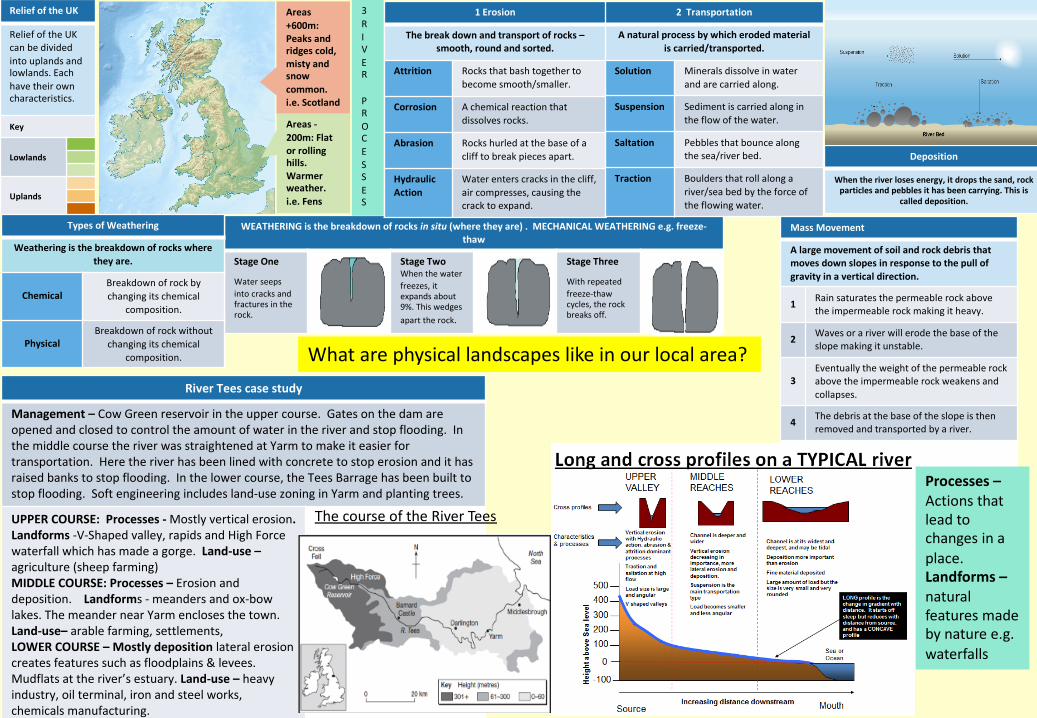
Relief of the UK
Relief of the UK can be divided into uplands and lowlands. Each have their own characteristics.
Key
Lowlands
Uplands
WEATHERING is the breakdown of rocks in situ (where they are) . MECHANICAL WEATHERING e.g. freeze-thaw
Stage One
Water seeps into cracks and fractures in the rock.
Stage TwoWhen the water freezes, it expands about 9%. This wedges apart the rock.
Stage Three
With repeated freeze-thaw cycles, the rock breaks off.
Areas +600m: Peaks and ridges cold, misty and snowcommon.i.e. Scotland
Areas -200m: Flat or rolling hills. Warmer weather. i.e. Fens
1 Erosion
The break down and transport of rocks –smooth, round and sorted.
Attrition Rocks that bash together to become smooth/smaller.
Corrosion A chemical reaction that dissolves rocks.
Abrasion Rocks hurled at the base of a cliff to break pieces apart.
Hydraulic Action
Water enters cracks in the cliff, air compresses, causing the crack to expand.
2 Transportation
A natural process by which eroded material is carried/transported.
Solution Minerals dissolve in water and are carried along.
Suspension Sediment is carried along in the flow of the water.
Saltation Pebbles that bounce along the sea/river bed.
Traction Boulders that roll along a river/sea bed by the force of the flowing water.
Mass Movement
A large movement of soil and rock debris thatmoves down slopes in response to the pull of gravity in a vertical direction.
1 Rain saturates the permeable rock above the impermeable rock making it heavy.
2 Waves or a river will erode the base of the slope making it unstable.
3Eventually the weight of the permeable rockabove the impermeable rock weakens and collapses.
4 The debris at the base of the slope is then removed and transported by a river.
Types of Weathering
Weathering is the breakdown of rocks where they are.
ChemicalBreakdown of rock by changing its chemical
composition.
Physical Breakdown of rock without
changing its chemical composition.
Deposition
When the river loses energy, it drops the sand, rock particles and pebbles it has been carrying. This is
called deposition.
River Tees case study
Management – Cow Green reservoir in the upper course. Gates on the dam are opened and closed to control the amount of water in the river and stop flooding. In the middle course the river was straightened at Yarm to make it easier for transportation. Here the river has been lined with concrete to stop erosion and it has raised banks to stop flooding. In the lower course, the Tees Barrage has been built to stop flooding. Soft engineering includes land-use zoning in Yarm and planting trees.
UPPER COURSE: Processes - Mostly vertical erosion. Landforms -V-Shaped valley, rapids and High Force waterfall which has made a gorge. Land-use –agriculture (sheep farming)MIDDLE COURSE: Processes – Erosion and deposition. Landforms - meanders and ox-bow lakes. The meander near Yarm encloses the town. Land-use– arable farming, settlements, LOWER COURSE – Mostly deposition lateral erosion creates features such as floodplains & levees. Mudflats at the river’s estuary. Land-use – heavy industry, oil terminal, iron and steel works, chemicals manufacturing.
3RIVER
PROCESSES
The course of the River Tees
What are physical landscapes like in our local area?
Processes –Actions that lead to changes in a place.Landforms –natural features made by nature e.g. waterfalls

River Management Schemes
Soft Engineering Hard Engineering
Afforestation – plant trees to soak up rainwater, reduces flood risk.Land-use zoning – planning what the land next to rivers is used for e.g. parks not housingEcological Flooding –naturally let areas flood, protect settlements.
Straightening Channel –increases velocity to remove flood water.Artificial Levees – heightens river so flood water is contained. Deepening or widening river to increase capacity for a flood.
Formation of Floodplains and levees
When a river floods, fine silt/alluvium is deposited on the valley floor. Closer to the river’s banks, the heavier materials
build up to form natural levees.
Nutrient rich soil makes it ideal for farming. Flat land for building houses.
Hydrographs and River Discharge
River discharge is the volume of water that flows in a river. Hydrographs who discharge at a certain point in a river changes over time in relation to rainfall
1. Peak discharge is the discharge in a period of time.
2. Lag time is the delay between peak rainfall and peak discharge.
3. Rising limb is the increase in river discharge.
4. Falling limb is the decrease in river discharge to normal level.
Water Cycle Key Terms
Precipitation Moisture falling from clouds as rain, snow or hail.
Interception Vegetation prevent water reaching the ground.
Surface Runoff Water flowing over surface of the land into rivers
Infiltration Water soaking into the ground.
Transpiration Water lost through leaves of plants.
Physical and Human Causes of Flooding.
Physical: Prolong & heavy rainfallLong periods of rain causes soil to become saturated leading runoff.
Physical: GeologyImpermeable rocks causes surface runoff to increase river discharge.
Physical: Relief Steep-sided valleys channels water to flow quickly into rivers causing greater discharge.
Human: Land Use Tarmac and concrete are impermeable. This prevents infiltration & causes surface runoff.
Physical features – Natural things like mountains, rivers, waterfalls, deserts.Human features – Things made by people like roads, buildings, farms.Sustainable development – Using rivers in a way that they will still be there for future generations to enjoy, whilst at the same time meeting the needs of local people. Soft engineering is sustainable.
Impermeable rocks – do not allow water to soak into them e.g. clay.

Task One: F and D – Learn the 13 physical features shown on the map. There will be a recall test next lesson. G and E: Also add the following to your map: Ben Nevis, Scafell Pike, Mount Snowdon, River Tees, Bridport.

Year 9 Summer 1 Homework TasksComplete one task per week. Hand-in day is on ……….............in Week A and ……………………… in
Week B.
Task Three: Complete one of the following creative tasks:(a) Write a poem about a river(b) Write a story about a flood event(c) Make a set of Top Trump cards for famous rivers
Task Four: Make a model showing how a waterfall is made.
Task Five: Collect newspaper or BBC news articles about a flood that happens while we are studying this topic. Colour code the information to show the causes, effects and responses.
Task Seven: Make revision resources for the mid unit assessment e.g. revision cards, poster, mind map. There are electronic versions at www.getrevising.co.uk
Task Six: A task will be set by your teacher and recorded on My Child At School
Task Two: F and D – Complete the River Tees Homework sheet. The first letter of each answer has been added to help you. G and E – Complete the River Tees Homework sheet.
https://www.youtube.com/watch?v=j3m0HzyNJE0&list=PL4bINZBFxm3lSAa8d9eLEMhF6pvml0xz1 Watch the River Tees programme here.
https://www.internetgeography.net/the-river-tees-case-study-landforms-of-erosion-and-deposition/