western hub stage 1 - eliwana and flying fish · western hub - stage 1 eliwana and flying fish...
TRANSCRIPT

Western Hub Stage 1 - Eliwana and Flying Fish
Conceptual Site Model and Operational Risk Assessment
16 February 2018
750WH-5700-RP-HY-0008_Rev0


Western Hub - Stage 1 Eliwana and Flying Fish Conceptual Site Model and Operational Risk Assessment Page 3 of 41
750WH-5700-RP-HY-0008_Rev0
TABLE OF CONTENTS
1. INTRODUCTION .............................................................................................................. 6
Project ..................................................................................................................... 6
Objectives ............................................................................................................... 6
Reference documents ............................................................................................ 6
2. SUMMARY OF PHYSICAL ENVIRONMENT .................................................................. 7
Operations............................................................................................................... 7
Geology ................................................................................................................. 10
Mine voids ............................................................................................................. 12
Hydrogeology ....................................................................................................... 12
2.4.1 Tertiary detrital aquifer .............................................................................. 12 2.4.2 Mineralised Brockman aquifer .................................................................. 13 2.4.3 Marra Mamba and Wittenoom aquifer ...................................................... 13 2.4.4 Aquitards .................................................................................................. 13
3. CONCEPTUAL SITE MODEL ........................................................................................ 14
Introduction ........................................................................................................... 14
Sources of potential contamination ................................................................... 15
3.2.1 Acid sulfate soils ....................................................................................... 16 3.2.2 Construction material ................................................................................ 16 3.2.3 Aboveground waste rock landforms ......................................................... 16 3.2.4 Ore stockpiles ........................................................................................... 17 3.2.5 Sub-grade ore stockpiles .......................................................................... 18 3.2.6 Tailings storage facilities .......................................................................... 18 3.2.7 Mine void wall rock ................................................................................... 19 3.2.8 Backfill material/ belowground waste rock storage ................................... 19 3.2.9 In situ dewatered and depressurised rock units ....................................... 19 3.2.10 Dewatering discharge ............................................................................... 20 3.2.11 Mine void water ........................................................................................ 20
3.2.11.1 Ephemeral, episodic and semi-permanent water ................................................ 20 3.2.11.2 Permanent water – not connected ...................................................................... 21 3.2.11.3 Permanent water –connected ............................................................................. 21 3.2.11.4 Summary of hydrology and hydrogeology ........................................................... 22
Transport pathways and other exposure routes ............................................... 24
3.3.1 Direct ........................................................................................................ 24 3.3.2 Seepage and leaching .............................................................................. 24 3.3.3 Groundwater flow ..................................................................................... 24 3.3.4 Surface water and runoff .......................................................................... 24
Receptors and other risks ................................................................................... 25
3.4.1 Site workers .............................................................................................. 25 3.4.2 Environmental value ................................................................................. 25 3.4.3 Pastoralists, public, Shire of Ashburton, indigenous and future land users
and other stakeholders ............................................................................. 26 3.4.4 Other downgradient land/tenement and water users ................................ 26 3.4.5 Aquifers .................................................................................................... 26 3.4.6 Drainage channels .................................................................................... 27 3.4.7 Soil ............................................................................................................ 28 3.4.8 Native flora ............................................................................................... 28

Western Hub - Stage 1 Eliwana and Flying Fish Conceptual Site Model and Operational Risk Assessment Page 4 of 41
750WH-5700-RP-HY-0008_Rev0
3.4.9 Terrestrial fauna ....................................................................................... 28 3.4.10 Subterranean fauna .................................................................................. 28 3.4.11 Heritage sites ............................................................................................ 29 3.4.12 Ecological degradation ............................................................................. 29 3.4.13 Regulatory risk .......................................................................................... 29 3.4.14 Financial risk ............................................................................................. 29 3.4.15 Reputational risk ....................................................................................... 30
4. RISK ASSESSMENT ..................................................................................................... 30
4.1.1 Purpose .................................................................................................... 30 4.1.2 Method ...................................................................................................... 30 4.1.3 Findings .................................................................................................... 38
5. REFERENCES ............................................................................................................... 41
List of tables
Table 1: Stratigraphy of mine area .............................................................................................. 10
Table 2: Mine voids and geology of waste .................................................................................. 12
Table 3: Summary of potential sources in operations and post closure ................................ 16
Table 4: List of mine voids showing planned depth and water regime ................................... 23
Table 5: Summary of potential receptors for operations and post-closure ............................ 25
Table 6: Risk rating matrix............................................................................................................ 31
Table 7: Consequence Categories ............................................................................................... 32
Table 8: Likelihood ........................................................................................................................ 33
Table 9: Key Definitions ................................................................................................................ 33
Table 10: Duration ........................................................................................................................... 33
Table 11: Extent of disturbance ..................................................................................................... 33
Table 12: Summary of conceptual site model during operations (A3 size page) ..................... 35
List of figures
Figure 1: Surface water features and catchments of the mine area ............................................ 8
Figure 2: Location and name of Western Hub mine voids considered in this assessment (geometry is subject to change over the project) ......................................................... 9
Figure 3: Conceptual geological profile of the Western Hub valley (vertically exaggerated, not to scale) ..................................................................................................................... 11
Figure 4: Contaminant-Transport-Receptor model ..................................................................... 14
Figure 5: Source-Pathway-Receptor connections during operations (A3 size page).............. 37
Figure 6: Conceptual Site Model ................................................................................................... 40
Units of Measure
°............................................................................................................................................. Degrees
a .................................................................................................................................... Annum / year
cm ..................................................................................................................................... Centimetre
Ga ............................................................................................................. Giga annum / billion years
GL/a ................................................................................................................. Giga litres per annum
kg H₂SO₄/t ..................................................................................... Kilograms sulfuric acid per tonne
ha ...................................................................................................................... hectares (10,000 m²)

Western Hub - Stage 1 Eliwana and Flying Fish Conceptual Site Model and Operational Risk Assessment Page 5 of 41
750WH-5700-RP-HY-0008_Rev0
L ................................................................................................................................................... Litre
m AHD ................................................................ Metres above Australian Height Datum (sea level)
mg ........................................................................................................................................ Milligram
mg CaCO₃/L ............................................................................. Milligram calcium carbonate per litre
mm/yr .................................................................................................................. millimetres per year
Mt ..................................................................................................................... Mega / Million tonnes
µg ....................................................................................................................................... Microgram
µS ...............................................................................................................................Micro-Siemens
t .................................................................................................................... Metric tonne (1 000 kg)
wt. % ......................................................................................................................... Weight per cent
Abbreviations and Acronyms
95% of ANZECC SLP .................................................................. 95% of Species limit of protection
ADWG ..................................................................................... Australian Drinking Water Guidelines
AHD ............................................................................................................ Australian Height Datum
AMD ............................................................................................. Acid and/or metalliferous drainage
ANZECC ............................ Australian and New Zealand Environmental and Conservation Council
ARMCANZ ........... Agriculture and Resources Management Council of Australia and New Zealand
BD .................................................................................................................. Dales George Member
BJ ................................................................................................................................ Joffre Member
BW ........................................................................................................... Whaleback Shale Member
BY ........................................................................................................ Yandicoogina Shale Member
CID .................................................................................................................... Channel Iron Deposit
DA .................................................................................................................... West Angela Member
DER .................................................................................. Department of Environmental Regulation
DIIS ........................................................................ Department of Industry, Innovation and Science
DITR...................................................................... Department of Industry, Tourism and Resources
DMP ......................................................................................... Department of Mines and Petroleum
DWER ............................................................. Department of Water and Environmental Regulation
EC .................................................................................................................... Electrical conductivity
HB .............................................................................................................. Brockman Iron Formation
HD .................................................................................................................... Wittenoom Formation
HG ....................................................................................................................... Bee Gorge Member
HM ....................................................................................................... Marra Mamba Iron Formation
HR ..................................................................................................... Mount McRae Shale Formation
JR ................................................................................................................... Roy Hill Shale Member
Mbgl ......................................................................................................... Metres below ground level
MM .......................................................................................................................... McLeod Member
MN .............................................................................................................. Mount Newman Member
MPA .......................................................................................................... Maximum potential acidity
Mtpa ........................................................................................................... Million tonnes per annum
MU ....................................................................................................................... Nammuldi Member
NAF ......................................................................................................................... Non-acid forming
NAG .................................................................................................................... Net acid generating
NEPM ......................................................................... National Environmental Protection Measures
NMD ............................................................................................................... Neutral Mine Drainage
PD/S....................................................................................................................... Dolerite dyke / sill
PT ................................................................................................................. Turee Creek Formation
TSF ................................................................................................................ Tailings storage facility
WRL .................................................................................................................. Waste rock landform
Western Hub - Stage 1 Eliwana and Flying Fish Conceptual Site Model and Operational Risk Assessment Page 6 of 41
750WH-5700-RP-HY-0008_Rev0
1. INTRODUCTION
Fortescue Metals Group Ltd (Fortescue) is proposing to develop the Western Hub Stage 1 Iron
Ore Mine Project (the Project) comprising the Eliwana and Flying Fish deposits in the Pilbara
region of Western Australia.
Project
The project area has been defined through the use of a development envelope and the estimated
mine life is 24 years. The project includes the development of above and below water table mine
pits, along with associated infrastructure, processing facilities, water management infrastructure
for groundwater abstraction and surplus water disposal, temporary and permanent waste
landforms and tailings storage facilities. The Western Hub Mine Project is associated with
Fortescue's existing approved Port, Railway and the Solomon Iron Ore Mine, and the proposed
Eliwana Railway.
The mining method will be conventional open cut. Ore from the Eliwana Mine will be transported
via the proposed Eliwana Railway (the subject of separate referrals under both the Environmental
Protection Act and Environmental Protection Biodiversity Conservation Act), before being
transported along the existing Fortescue Rail network for export.
Objectives
The main aim of the Conceptual Site Model and Operational Risk Assessment is to outline and
describe the contaminant-transport-receptor (CTR) model based on the National Environmental
Protection Measures (NEPM) guidelines for assessing contamination (NEPM, 2013).
Reference documents
This document the Western Hub Stage 1 Conceptual Site Model and Risk Assessment document
number 750WH-5700-RP-HY-0008 was prepared using the following resources:
Acid and/or Metalliferous Drainage Management Plan, Report Ref.: 100-PL-EN-1016_Rev1
(Fortescue, 2014)
Western Hub Stage 1 – Geological Summary Report (Fortescue, 2015)
Western Hub - Hydrogeological Conceptual Model Report, Report Ref.: 1671484-002-R-
Rev0; Golder Associates (Golder, 2017);
Western Hub Stage 1 – Eliwana and Flying Fish Subsurface Material Characterisation
Assessment, Report Ref.: 750WH-5700-RP-HY-0007 (Fortescue, 2017a);
Western Hub Stage 1 Closure Risk Assessment, Report Ref.: 750WH-5700-RP-HY-0009
(Fortescue, 2017b);
Western Hub Stage 1 Conceptual Mine Void Water Assessment, Report Ref.: 750WH-5700-
RP-HY-0010 (Fortescue, 2017c).

Western Hub - Stage 1 Eliwana and Flying Fish Conceptual Site Model and Operational Risk Assessment Page 7 of 41
750WH-5700-RP-HY-0008_Rev0
2. SUMMARY OF PHYSICAL ENVIRONMENT
The project is located in the Pilbara biogeographic region of Western Australia (WA), where the
climate is semi‐arid to arid. The climate of the Pilbara Region is characterised by two distinct
seasons with seasonal periodic rainfall mainly during the summer months and high evaporation
rates. The gradient varies from open, flat topography to areas of steep hills, gorges, and gullies.
The study area is located in a valley extending east to west between the main Hamersley Range
to the north and Brockman Ridge to the south reaching elevations of up to 1,020 m AHD. The
project area is a constrained fluvial valley system, with central surface drainage and an underlying
palaeovalley groundwater system.
The project is situated within the greater Ashburton River catchment with the most significant
drainage line within the mine being the Duck Creek subcatchment (which encompasses Caves
Creek and Boolgeeda Creek), a tributary of the Ashburton River, which crosses the central section
of the study area and flows northwest. Several unnamed minor to mid-order tributaries of Duck
Creek also intersect the study area. With the main central channel named Pinarra Creek. Surface
drainage is ephemeral, with a few persistent (possibly permanent) pools along the main channel
of Duck Creek (Johnson & Wright, 2001). Surface water flow direction from the mine area is
predominantly southerly in the eastern catchments and westerly on the eastern catchments
Figure 1.
Large portions of the project area are used for pastoral grazing and substantial mineral exploration
has been undertaken in localised areas. The condition of vegetation within the Project Area
ranges from Completely Degraded/Cleared to Excellent, with the majority falling within the Very
Good to Excellent categories.
Operations
The planned mine voids are given in Figure 2. Operational elements of the Project include:
Mining in the Eliwana Area includes below water table mining, operational temporary standing
water and permanent and ephemeral post closure pit lakes in mine voids;
Mining in the Flying Fish Area includes above water table mining and ephemeral, surface
water-driven, pit lakes in mine voids;
Ore processing with waste disposal in tailing storage facilities (TSF) and waste rock dumps
(WRDs);
Water supply from a combination of mine dewatering and water supply borefields;
Surplus water resulting from mine dewatering will be managed through a combination of
surface discharge and controlled aquifer reinjection.

Western Hub - Stage 1 Eliwana and Flying Fish Conceptual Site Model and Operational Risk Assessment Page 8 of 41
750WH-5700-RP-HY-0008_Rev0
Figure 1: Surface water features and catchments of the mine area

Western Hub - Stage 1 Eliwana and Flying Fish Conceptual Site Model and Operational Risk Assessment Page 9 of 41
750WH-5700-RP-HY-0008_Rev0
Figure 2: Location and name of Western Hub mine voids considered in this assessment (geometry is subject to change over the project)

Western Hub - Stage 1 Eliwana and Flying Fish Conceptual Site Model and Operational Risk Assessment Page 10 of 41
750WH-5700-RP-HY-0008_Rev0
Geology
The generalised stratigraphy of the Hamersley Basin, as interpreted by Johnson & Wright (2001),
is shown in Table 1. The bedded stratigraphy dips to the south with the oldest units to the north,
progressing through overlying younger material to the south (Figure 3).
Table 1: Stratigraphy of mine area
Unit Description
Tertiary Detritals (Qa/Ta/Td)
Overlying the calcrete and silcrete are mainly poorly sorted, unconsolidated gravels, comprising banded iron, ironstone or dolerite in a clay matrix. Calcrete
(or dolomite) and silcrete is commonly found.
Channel Iron Deposits (CID)
Robe Pisolite unaltered hematite-goethite pisoliths.
Dolerite dykes (PD) Near vertical trend NW-SE, NNW-SSE and NE-SW
Dolerite sill (PS) Intrudes into the J3 units
Hamersley Group
Bro
ck
ma
n Iro
n F
orm
ati
on
(H
B)
Yandicoogina Shale Member (BY)
Alternating chert and shale up to 60 m thick, does not occur in waste
Jo
ffre
Mem
be
r
(BJ)
Unit 6 (J6)
Brockman Iron Formations consist of the highest grade bedded iron deposits. Homogeneous with approximately 330 m of alternating banded iron formation and shale bands. The banded iron comprises interbedded chert and iron rich
material.
Unit 5 (J5)
Unit 4 (J4)
Unit 3 (J3)
Unit 2 (J2)
Unit 1 (J1)
Whaleback Shale Member (BW)
Approximately 50 m thick, this member consists of thinly bedded shales with thicker chert or BIF bands, weathered with supergene enrichment of BIF bands
Dale
s G
eo
rge
Mem
ber
(BD
)
Unit 4 (D4) An alternating sequence of BIF and shale macro-bands. The BIF bands comprise of centimetre thick bands of chert and iron rich material in a chert matrix. The shale bands comprise primarily volcanogenic and carbonate
turbidite. Member is ~ 142 m thick
Unit 3 (D3)
Unit 2 (D2)
Unit 1 (D1)
Mount McRae Shale Formation (HR)
Comprises thinly laminated, fissile shale with minor subordinate amounts of chert, dolomite and BIF. Unweathered unit occurs as black graphitic and
chloritic shale with significant pyrite that represents a potential spontaneous combustion and acid forming material risk when exposed through mining
Mount (Bruno’s Band) Three prominent banded iron formation (BIF) bands, separated by laminated mudstone and minor chert and dolomite with the upper a recognisable regional
marker known as Bruno’s band. Thickness is varies from 30 to 45 m Silvia Formation (HS)
Wit
ten
oo
m
Fo
rma
tio
n (
HD
)
Bee Gorge Member (HG)
A thinly laminated fissile argillite also contains subordinate thickness of carbonate, chert, volcaniclastics and iron formation with distinct marker bed:
the Main Tuff Interval, Member ranges in thickness from 100 to 227 m
Paraburdoo Member (HP)
Comprises a majority of dolomite with minor amounts of chert and argillite (clay, mudstone, shale), thickness between 260 and 420 m.
West Angela Member (DA)
Predominantly massive to laminated dolomite interbedded with shaley dolomite
with pyrite and chert, between 30 and 50 m thick.
Marr
a M
am
ba I
ron
Fo
rmati
on
(H
M) Mount Newman
Member (MN) Banded iron interbedded with carbonate and shale, between 45 and 60 m thick
containing eight identified shale bands
McLeod Member (MM)
Banded iron, chert and carbonate along with interbedded shales, 25 to 45 m. The upper most beds contain the most shale units, closely spaced together.
Nammuldi Member (MU)
Cherty, banded iron formation interbedded with thin shales. The un-mineralised Nammuldi Member is between 75 and 100 m thick
Fortescue Group Jeerinah Formation (FJ)
Dark grey to black shale, commonly with spheroidal pyrite concretions. Roy Hill Shale Member (JR)

Western Hub - Stage 1 Eliwana and Flying Fish Conceptual Site Model and Operational Risk Assessment Page 11 of 41
750WH-5700-RP-HY-0008_Rev0
Figure 3: Conceptual geological profile of the Western Hub valley (vertically exaggerated, not to scale)

Western Hub - Stage 1 Eliwana and Flying Fish Conceptual Site Model and Operational Risk Assessment Page 12 of 41
750WH-5700-RP-HY-0008_Rev0
Mine voids
The below table lists the planned mine voids indicating geology of waste and ore units. Where
ore units are not mineralised these will also be sent to waste.
Table 2: Mine voids and geology of waste
Planned mine void name Ore units Waste material
Broadway West 1, 2 & 3 Broadway East 1 & 2 Broadway
McLeod (MM) Member Mount Newman (MN) Member
Tertiary Detritals (Td) Channel Iron Deposits (CID) Bedded Iron Deposits (BID) West Angela (DA) Member
Broadway South Dales Gorge (BD) Bedded Iron Deposits (BID) Mount McRae Shale (HR)
Eagles Nest East 1 (also called Swan)
Joffre (BJ) Member Whaleback Shale (BW) Member Dales Gorge (BD) Member
Tertiary Detritals (Td) Mount McRae Shale (HR) Wittenoom (HD) Formation
East 2, 3 & 4 Mount Newman (MN) Member Tertiary Detritals (Td) West Angela (DA) Member
MM1 (now called Talisman East MM4-6 (also called M6)
McLeod (MM) Member Mount Newman (MN) Member
Tertiary Detritals (Td) West Angela (DA) Member
P Tenement 1 (P1) P Tenement 2 (P2)
Joffre (BJ) Member Whaleback Shale (BW) Member
Joffre (BJ) Member
P Tenement 3 (P3) Joffre (BJ) Member Whaleback Shale (BW) Member
Joffre (BJ) Member Whaleback Shale (BW) Member Dolerite dykes (PD)
P Tenement 4 (P4) Dales Gorge (BD) Member Dales Gorge (BD) Member
Talisman 1 & 2 McLeod (MM) Member Mount Newman (MN) Member
Tertiary Detritals (Td) West Angela (DA) Member
West End Joffre (BJ) Member Whaleback Shale (BW) Member Dales Gorge (BD) Member
Tertiary Detritals (Td) Dolerite Sill (PS) Mount McRae Shale (HR) Wittenoom (HD) Formation
West Side Joffre (BJ) Member Whaleback Shale (BW) Member Dales Gorge (BD) Member
Mount McRae Shale (HR) Wittenoom (HD) Formation
Flying Fish McLeod (MM) Member Mount Newman (MN) Member
Tertiary Detritals (Td) Channel Iron Deposits (CID) West Angela (DA) Member
Hydrogeology
The hydrogeological environment is based on the geological model, airborne total magnetic
intensity interpretation, hydrogeological and resource bores (Golder, 2017).
2.4.1 Tertiary detrital aquifer
Shallow Tertiary Detrital material comprising alluvial/colluvial valley infill and calcrete deposits
does not strictly function as an aquifer as it is unsaturated, however flow through this material will
occur during high rainfall events. It is for the most part unconfined and as such may function as a

Western Hub - Stage 1 Eliwana and Flying Fish Conceptual Site Model and Operational Risk Assessment Page 13 of 41
750WH-5700-RP-HY-0008_Rev0
flow pathway, however, Tertiary clays in the valley may act as a local aquiclude preventing
connection with the Wittenoom Aquifer below. Channel Iron Deposits (CID) of unknown and
limited extent occur within the project area, but are generally confined to the Flying Fish area.
2.4.2 Mineralised Brockman aquifer
The mineralised Brockman Iron Formation (comprising Joffre, Whaleback Shale and Dales Gorge
Members) is formed by the same hypergene enrichment that formed the bedded mineralisation
in the Hamersley Basin. The replacement by groundwater of silicate and carbonate minerals with
goethite results in stratigraphic thinning and associated increases in porosity and permeability.
The Whaleback Shale Member is assumed to be part of the aquifer where it is
weathered/mineralised.
2.4.3 Marra Mamba and Wittenoom aquifer
The Wittenoom Aquifer includes all weathered Members of the Wittenoom Formation as well as
the mineralised upper Newman Member of the underlying Marra Mamba Iron Formation which is
connected. The West Angela Member comprises shaley dolomite and interbedded banded iron
formation, while the Bee Gorge and Paraburdoo Members tend to contain mostly dolomite with
the highest permeability.
The upper Mount Newman Member is sometimes separated from the lower Mount Newman
Member by an impermeable shale band. To account for this the Newman Member will be tested
separately to determine the connectivity. Where the overlying Tertiary Detritals materials are
saturated and in hydraulic connection with the groundwater contained in the Wittenoom Formation
these sediments will be included in the Wittenoom Aquifer.
2.4.4 Aquitards
Aquitards slow the flow of groundwater from one aquifer to another. The unmineralised Brockman
Iron (HB) Formation, Yandicoogina Shale (BY) Member, Marra Mamba Iron (HM) Formation,
Mount Sylvia (HS) Formation and Roy Hill Shale Member (Jr) as well as unweathered members
of the Wittenoom Formation are considered aquitards. Dolerite dykes and sills are also considered
aquitards. The Mount McRae Shale (HR) is also considered an aquitard and acts as a boundary
that partitions the Mineralised Brockman Aquifer from the Wittenoom Aquifer. A prominent
dolerite sill occurs in the J3 unit of the Joffre (BJ) Member on the southern limb of the Brockman
Syncline. These aquitards act to bound the mining area to the south by the Yandicoogina Shale
(BY) Member of the Brockman Iron Formation and to the north by Roy Hill Shale (JR) Member of
the Jeerinah Formation (FJ), resulting in little to no movement of groundwater and effective
groundwater compartmentalisation.

Western Hub - Stage 1 Eliwana and Flying Fish Conceptual Site Model and Operational Risk Assessment Page 14 of 41
750WH-5700-RP-HY-0008_Rev0
3. CONCEPTUAL SITE MODEL
The conceptual site model (CSM) describes the potential sources of geochemical contamination
in the mining area and assesses the transport pathways to any local or regional receptors. As the
major transport pathways relate to water movement and receiving environments the risk
assessment has focussed on them. This is a qualitative risk assessment designed to highlight
areas of high risk and potential uncertainty that require management to mitigate, or further study
to quantify more fully.
Introduction
In the context of a geochemical risk assessment, contamination is defined as an increase or
decrease in any chemical parameter compared to the natural conditions that are present in the
environment, so that such a decrease or increase may result in a significant impact to any human
or environmental factor or value. In order that the final landform is geochemically safe, stable,
non-polluting and capable of sustaining an ecosystem, the reactivity and weathering potential of
all potential sources is required to be assessed so that any risks can be managed. Potential
sources are discussed in the general case with all potential risks highlighted, not certainties.
The risk assessment follows the contaminant-transport-receptor (CTR) model where risk is only
present if these three factors are all present and connected (Figure 4). If there is no source, there
is no risk, if there is no pathway to connect source and receptor there is no risk, and if there is a
source and a pathway but no receptor, there is no risk. The risk assessment following will evaluate
the likelihood of risks prior to and after mitigation methods.
Figure 4: Contaminant-Transport-Receptor model
While the Subsurface Materials Characterisation Assessment (750WH-5700-RP-HY-0007) has
identified the material that is likely to pose the greatest risk, ore bodies and geological formations
are heterogeneous and continuous characterisation with continued investigation of the ore body

Western Hub - Stage 1 Eliwana and Flying Fish Conceptual Site Model and Operational Risk Assessment Page 15 of 41
750WH-5700-RP-HY-0008_Rev0
is required in a phased approach coinciding with the increasing level of knowledge of the area
and resource geology (Fortescue, 2017a).
The development of the CSM closely follows the Acid and Metalliferous Drainage Management
Plan (100-PL-EN-1016_Rev1) details a high level method of investigation to be conducted during
each phase of mining to answer specific informational requirements (Fortescue, 2014). The AMD
Management Plan was designed to deal with a general case and to be applicable to all sites. In
addition to this model of ascertaining risk, the closure principle requirement that the final
landforms are geochemically safe, stable, non-polluting and capable of sustaining an ecosystem
is also taken into consideration as rock weathering and the potential for contamination to the
environment continues for millennia after mining has ceased.
In terms of the AMD management plan this assessment satisfies the knowledge requirements for
the Exploration, Prefeasibility, and Feasibility stages. Sufficient testing has been conducted at
this stage to identify the major risks and materials that require specific material handling
consideration. This information will then inform the mine planning and waste rock landform
designs. It is clear that the potential deleterious material comprises a minor volume which is easily
encapsulated in the bulk of the benign surplus rock and that careful scheduling and design will
mitigate most risks posed by excavated, potentially-AMD generating material. The conclusions
from the Subsurface Characterisation Assessment (750WH-5700-RP-HY-0007) directly affect
landform planning and construction during operations, as well as closure strategies (Fortescue,
2017a). As more information is gathered in the successive stages of the project the AMD
management methods and assumptions may change to address changing mine conditions,
community expectations, stakeholder inputs and the emergence of new, more cost-effective AMD
management methods as the mine proceeds (DIIS, 2016c).
Sources of potential contamination
A source of contamination is considered to be any material, either ore, rock, soil or water that has
undergone disturbance as a result of mining processes such that the geochemical composition
may be affected or degraded. Airborne particulates are not considered in this contamination
assessment as air quality and dust is addressed separately. In addition, physical sources of
contamination, such as: sediment loads, suspended matter, breathable fibres or gases, are not
considered here. Other potential sources of contamination associated with the operation such as
hydrocarbons, pesticides or sewerage have not been assessed at this stage but may be included
as part of this process once construction has been completed.
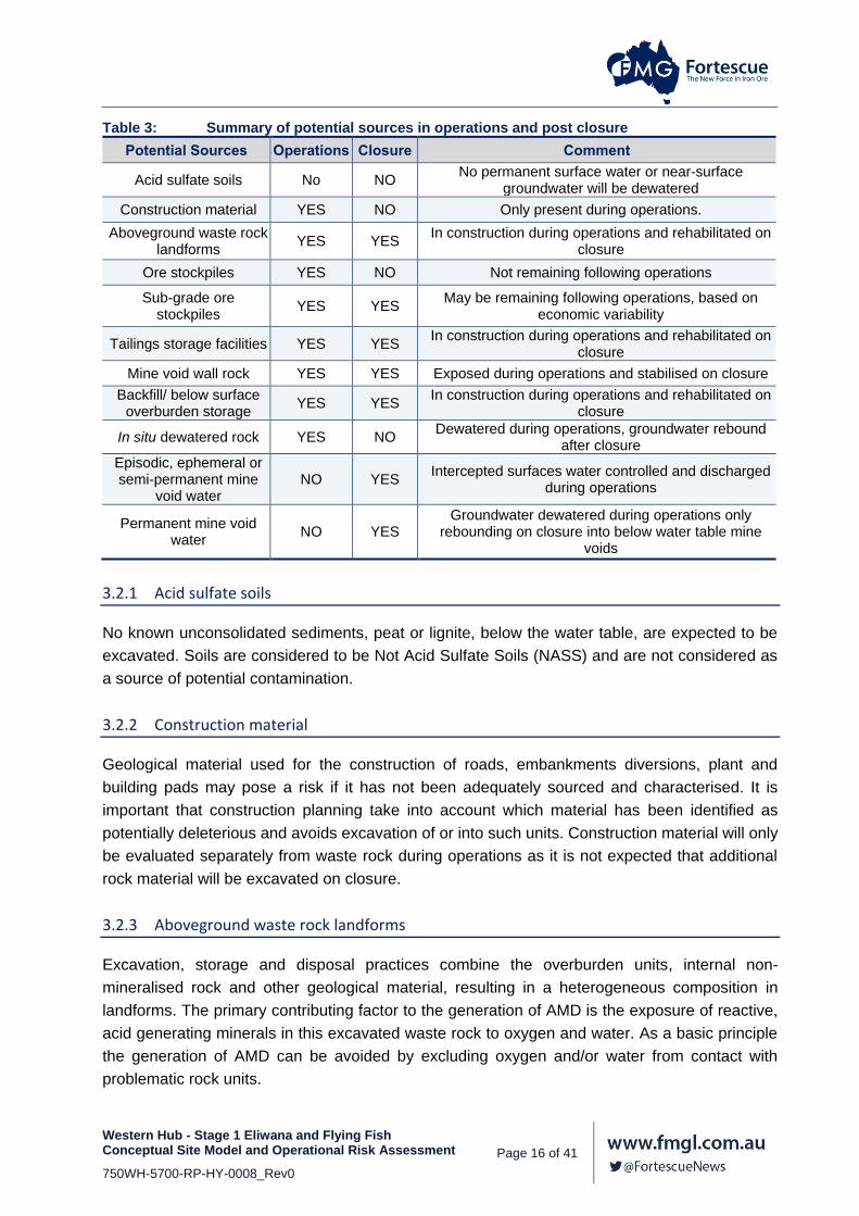
Table 3 summarises the potential sources of contamination detailed in this section and in which
stage they pose a risk.
Western Hub - Stage 1 Eliwana and Flying Fish Conceptual Site Model and Operational Risk Assessment Page 16 of 41
750WH-5700-RP-HY-0008_Rev0
Table 3: Summary of potential sources in operations and post closure
Potential Sources Operations Closure Comment
Acid sulfate soils No NO No permanent surface water or near-surface
groundwater will be dewatered
Construction material YES NO Only present during operations.
Aboveground waste rock landforms
YES YES In construction during operations and rehabilitated on
closure
Ore stockpiles YES NO Not remaining following operations
Sub-grade ore stockpiles
YES YES May be remaining following operations, based on
economic variability
Tailings storage facilities YES YES In construction during operations and rehabilitated on
closure
Mine void wall rock YES YES Exposed during operations and stabilised on closure
Backfill/ below surface overburden storage
YES YES In construction during operations and rehabilitated on
closure
In situ dewatered rock YES NO Dewatered during operations, groundwater rebound
after closure
Episodic, ephemeral or semi-permanent mine
void water NO YES
Intercepted surfaces water controlled and discharged during operations
Permanent mine void water
NO YES Groundwater dewatered during operations only
rebounding on closure into below water table mine voids
3.2.1 Acid sulfate soils
No known unconsolidated sediments, peat or lignite, below the water table, are expected to be
excavated. Soils are considered to be Not Acid Sulfate Soils (NASS) and are not considered as
a source of potential contamination.
3.2.2 Construction material
Geological material used for the construction of roads, embankments diversions, plant and
building pads may pose a risk if it has not been adequately sourced and characterised. It is
important that construction planning take into account which material has been identified as
potentially deleterious and avoids excavation of or into such units. Construction material will only
be evaluated separately from waste rock during operations as it is not expected that additional
rock material will be excavated on closure.
3.2.3 Aboveground waste rock landforms
Excavation, storage and disposal practices combine the overburden units, internal non-
mineralised rock and other geological material, resulting in a heterogeneous composition in
landforms. The primary contributing factor to the generation of AMD is the exposure of reactive,
acid generating minerals in this excavated waste rock to oxygen and water. As a basic principle
the generation of AMD can be avoided by excluding oxygen and/or water from contact with
problematic rock units.

Western Hub - Stage 1 Eliwana and Flying Fish Conceptual Site Model and Operational Risk Assessment Page 17 of 41
750WH-5700-RP-HY-0008_Rev0
Rock landforms are present from the start of operations and will continue to constitute a potential
following closure. Classification and analysis of rock samples at the Western Hub has determined
that;
The majority of material is non-acid forming but the Mount McRae Shale Formation has the
potential to generate acid and neutral or alkaline metalliferous drainage;
Mount McRae Shale occurs in the wall of the West End, West Side and in minor amounts in
the Eagles Nest mine voids;
There is an unlikely chance (3-30%) that chromium, copper, selenium, thallium and vanadium
will occur above the ANZECC 95% of species limit of protection in any drainage from waste
rock;
There is a rare chance (0-3%) that arsenic, cadmium, cobalt and nickel will occur above the
ANZECC 95% of species limit of protection in any drainage from waste rock.
Aluminium, iron, manganese and zinc are highly soluble in this environment with large
reservoirs for long-term weathering. These metals are locally, naturally elevated but may
exceed background concentrations and impact fauna and flora;
Elements of specific concern are arsenic and selenium which occur in samples from Mount
McRae Shale and Wittenoom Formation. There is minor concern that cobalt, chromium,
copper and nickel may also be present at elevated concentrations;
The West Angela Member shale subunits are pyritic at the base of the unit, just above the
Mount Newman ore is likely to result in acidic and metalliferous drainage;
Weathering testing indicates that aluminium, cobalt, manganese and zinc, with minor concern
that beryllium and thallium, may pose a long-term risk;
While the occurrence of some elements indicates the possibility of trace element leaching from
unsegregated material, the frequency and magnitude of the occurrences results in a low potential
impact and as a result they are not included in the risk assessment. Surface and groundwater
hardness is elevated and environmental tolerance for cadmium, copper, chromium, nickel and
lead is higher, so they are not considered to be of concern.
For the purposes of this CSM aluminium, arsenic, cobalt, manganese, selenium and zinc with
minor cobalt, beryllium and thallium are considered potential contaminants of concern from
rock material at the Western Hub during operations and post-closure.
3.2.4 Ore stockpiles
Ore stockpiles are present during operations only and will be exhausted once mining is complete.
An estimation of whether stockpiles may have an impact was based on the water leach results of
only the ore units Dales Gorge (BD) and Joffre (BJ) Members and samples from the Marra Mamba
Iron Formation (HM). Should any contamination occur this will be addressed during
decommissioning and will not be a risk post-closure. Classification and analysis of ore units at the
Western Hub has determined that:

Western Hub - Stage 1 Eliwana and Flying Fish Conceptual Site Model and Operational Risk Assessment Page 18 of 41
750WH-5700-RP-HY-0008_Rev0
Ore units comprise Brockman Iron and Marra Mamba Formations;
Most samples were non-acid forming. Only stockpiled basal Dales Gorge Member ore, unit
D1 poses a risk for acid generation but it is unlikely to be mineralised;
There is a possible chance (30-70%) that aluminium, boron, barium, manganese and lead
will be present in any stockpile drainage;
There is an unlikely chance (3-30%) that cadmium, chromium, copper, iron, cadmium, copper,
selenium, tin and zinc will be present in any stockpile drainage;
There is a rare chance (0-3%) that molybdenum, nickel, thallium and uranium will be present
in any stockpile drainage.
Of these elements that occur frequently in water leach samples, only aluminium, iron,
manganese, selenium, thallium and zinc have any concentrations above the ANZECC 95% of
SLP. There are two to three individual instances of cadmium, chromium and copper that
marginally exceed the HMTV. These occurrences are rare and not considered to be a concern.
3.2.5 Sub-grade ore stockpiles
Sub-grade stockpiles are differentiated from run-of-mine (ROM) ore stockpiles as there is a risk
they may be stored for much longer periods of time depending on the ore price and mine product
strategy or never used at all. As a result they may be subjected to much longer periods of
weathering and oxidation than normal ROM piles. They are potentially long-term sources of AMD,
and may still be present on closure if economic factors do not result in use as resource. As such,
they may pose a higher risk than well-designed surplus rock storage areas with little to no planning
as to their location and construction.
The same elements that occur frequently in ore leaches are a risk for sub-grade ore: aluminium,
iron, manganese, selenium, thallium and zinc with the added risk of acid generation from basal
Dales Gorge Member unit, D1.
3.2.6 Tailings storage facilities
Minimal beneficiation is planned and less than 100 million tonnes is estimated for tailings
generation over the life of the mine. Tailings material will be generated during operations and
may be stored above or below the water table. Tailings comprises milled, ground ore residue,
largely aluminium-oxyhydroxides and ferrosilicates, that has been gravity separated and
extracted groundwater as the slurry fluid. Of these the water is more likely to be transported while
the consolidated solids will be present post-closure.
Preliminary classification and analysis of tailings material has determined that, in general, tailings
material is not considered a risk for acid generation, saline or metalliferous drainage, however
there is an indicated risk of minor chromium drainage. The regional groundwater generally has
elevated hardness and as a result the risk from chromium in drainage is not likely to be high.

Western Hub - Stage 1 Eliwana and Flying Fish Conceptual Site Model and Operational Risk Assessment Page 19 of 41
750WH-5700-RP-HY-0008_Rev0
3.2.7 Mine void wall rock
It is likely that Mount McRae Shale (HR) Formation and basal Dales Gorge (BD) Member units
will be exposed in the West End and West Side mine voids.
It is likely that the West Angela (DA) Member shale unit of the Wittenoom Formation (HD) will be
exposed in the northern mine voids and may influence the quality of mine void water both
ephemeral and permanent.
For the purposes of this CSM aluminium, arsenic, cobalt, manganese, selenium and zinc with
minor cobalt, beryllium and thallium are considered potential contaminants of concern from
waste rock and mine void walls at the Western Hub during operations and post-closure.
3.2.8 Backfill material/ belowground waste rock storage
In some instances mine voids may be completely or partially backfilled either to make the mine
void safe and stable or as a preferred option for the disposal of waste material. Backfill may
include waste rock or tailings and may be placed below or above the water table in the mine void.
If backfill is not well planned and characterised it may be a cause of AMD in contact with either
groundwater and/or surface flow.
The best environmental outcome may, however, conversely, include backfilling deleterious waste
such Mount McRae shale either above or below the water table to reduce weathering, exclude
oxygen or capture unavoidable drainage in a terminal sink. If a mine void situated in a floodplain
contains backfill material the risk to surface water is also required to be assessed.
For the purposes of this CSM aluminium, arsenic, cobalt, manganese, selenium and zinc with
minor cobalt, beryllium and thallium are considered potential contaminants of concern from
waste material at the Western Hub during operations and post-closure.
3.2.9 In situ dewatered and depressurised rock units
Pyritic shale units that are either situated in the footwalls, or near to the edges of the pits present
a risk that dewatering activities may influence the water levels in these units. However, pump
testing of the mine void areas have indicated that the water levels in shale units adjacent to mine
voids are disconnected and do not respond during pumping. The impermeability of the shale units
indicate they will not be effected by dewatering and are unlikely to cause AMD. Groundwater
appears to be highly compartmentalised with no or very low flow through the shale units from
north to south and is further segregated from east to west by dolerite intrusions, which also act
as flow boundaries. The risk of in situ dewatering of pyritic shale is therefore low.
However, in order that the stability of the mine void walls is not compromised during mining by
high pressure differentials between the void and the shale unit, it is possible that bores will be
installed to depressurise these units, which may result in AMD during operations. Any AMD
caused by the installation of depressurisation bores will be required to be pumped out to facilitate

Western Hub - Stage 1 Eliwana and Flying Fish Conceptual Site Model and Operational Risk Assessment Page 20 of 41
750WH-5700-RP-HY-0008_Rev0
operations and treated or diluted so as not to damage infrastructure, so it is not expected to have
an environmental impact and volumes will be very low and will be captured in the mine void.
3.2.10 Dewatering discharge
The groundwater extracted from ore units to facilitate mining is expected to be discharged to
surface water drainage lines. The preliminary baseline groundwater and surface water quality is
given in the Subsurface Material Characterisation Assessment, Section 3.5.3 (Fortescue, 2017a).
Groundwater is described as a pathway in the following section, however in this case, it is
removed from the natural environment of the aquifer and discharged to the surface where there
may be an impact on the ecology. The main difference in water quality is the higher salinity of
groundwater as compared to surface water, and consequently all major ions, alkalinity and minor
elements affected by salinity e.g. boron, barium. In terms of metals: copper and manganese are
marginally higher in groundwater while aluminium and zinc are higher in surface water.
While it is possible that the increased salinity may have an impact, flora and fauna communities
of the Pilbara are usually salt tolerant, and the increased nutrients from calcium and magnesium
and moisture, are likely to offset any negative effects. Dewatering discharge will be present during
the operational stage and will not occur following closure.
3.2.11 Mine void water
It has been determined through modelling that following cessation of operations, remaining mine
voids will be in contact with both surface and groundwater environments and will result in both
the permanent and temporary presence of water. Mine void water is not considered a
contamination risk during operations unless an extremely large and rare event results in egress.
This type of event is unlikely to be a contamination risk however as it will comprise highly diluted
rainwater. A brief outline of mine void water risk is given as follows but the Conceptual Mine Void
Water Assessment is outlined in report number 750WH-5700-RP-HY-0010 (Fortescue, 2017c).
3.2.11.1 Ephemeral, episodic and semi-permanent water
Ephemeral and episodic water in mine voids is likely to comprise only direct precipitation and
small volumes of wall runoff. This water will infiltrate and evaporate quickly and be fresh in quality,
resulting in a minimal build-up of salts (evaporites) at the base of the mine void. For voids mined
above the water table, and not in connection to a creek system, precipitation and runoff will be
the sole source of temporary water and are not considered to pose a high risk of potential
contamination.
Semi-permanent water may result from a seasonal increase in groundwater levels that result in a
minor ingress into mine voids or where a mine void is in connection with a creek system during
periods of high flow such that captured surface water takes a longer amount of time to evaporate
than incidental rainfall. The duration of semi-permanent mine water is likely to be on the order of
several months. The quality of this type of water body will also be highly influenced by whether
the source of water is precipitation and minor wall rock runoff or more saline groundwater, and as

Western Hub - Stage 1 Eliwana and Flying Fish Conceptual Site Model and Operational Risk Assessment Page 21 of 41
750WH-5700-RP-HY-0008_Rev0
such the amount of evaporative salts will likely be higher than ephemeral and episodic water but
still low, and is unlikely to pose a high risk as a result of flow terminating at the lowest point of the
mine void and becoming a sink.
3.2.11.2 Permanent water – not connected
Voids mined below the water table will recover to have permanent groundwater inflow once
dewatering ceases into the mine void. During operations no permanent mine void water will be
present as active operations will be dewatered. The pit lakes will only form and constitute a
potential source of contaminants on closure. These mine voids are not connected to surface water
and are reliant on groundwater almost entirely. These mine voids are likely to be terminal sinks
as a result of high evaporation as well as the low permeability shale units, and dolerite dykes that
bound the mine area to the north and south, and the east and west, respectively, preventing
outflow. Mine void water in West Side, West End and Eagles Nest may be in contact with Mount
McRae Shale in the wall rock, while M6 (also called MM4-6) mine void water may be in contact
with West Angela Member Shale in the wall rock. This water will be groundwater inflow, initially
of similar quality to background observations, diluted marginally with fresher quality precipitation
and runoff but will deteriorate over time as a result of evapoconcentration and exposed shale
units that leach metals. However, because of the very low likelihood that these sources will be in
contact with any transport pathway, the risk of contamination posed to the environment is low.
3.2.11.3 Permanent water –connected
Some mine voids may be in contact with the environment as a result of their position in the
floodplain. These mine voids may have groundwater and surface water ingress or only surface
water inflows. The majority of these mine voids will be terminal sinks as a result of the high
evaporation. Some of the voids with only surface water inflows may be shallow enough to resume
creek flow but accumulated salts from evaporation of smaller surface water inflows will be low
and the impact of any outflow will be negligible.
There is higher surface water ingress (than from just precipitation and runoff) from creek flow into
the Talisman and Broadway East mine voids. Both Talisman and Broadway East have a less than
1% chance of outflow which would only occur in very large, rare flood events of a volume greater
than 1:100, when the creek intersected by this mine void may resume flow. It is likely that such a
large volume of water would dilute any evapoconcentrated water to such an extent that
contamination is unlikely to pose a risk.
The Broadway West mine void however, has a high likelihood of outflow from surface and
groundwater ingress. Outflow is likely to occur on a yearly basis with seasonal rainfall events as
the catchment to which Broadway West is connected is large. Frequent outflow and large volumes
of surface water inflow, will result in a much lower likelihood of poor quality water by
evapoconcentration. However, some West Angela (DA) Member shale occurs in the wall rock and
may contribute to metal leaching. Surface water flow from these mine voids will travel west to
Duck Creek.

Western Hub - Stage 1 Eliwana and Flying Fish Conceptual Site Model and Operational Risk Assessment Page 22 of 41
750WH-5700-RP-HY-0008_Rev0
At this stage of the project planned mine void designs are subject to a high degree of variability.
The water balance can only be estimated at this stage, as a result of the large number of variables
required to be included in modelling, namely operational dewatering, climate change, infiltration,
flood events, rainfall intensity, aquifer recharge and potential interaction between closed mine
voids. When the amount of salt and metals contributed to the environment can be accurately
modelled, mine voids may be redesigned in order to reduce any unacceptable risks.
Contaminants of concern combine elements naturally occurring in groundwater with dissolved
metals from leaching and long-term weathering tests of rock material representing wall rock,
waste rock and potential backfill. For the purposes of this CSM acid generation and neutral/
alkaline drainage containing aluminium, arsenic, manganese, selenium and zinc with minor
beryllium, cobalt and thallium are considered potential contaminants of concern. The risks for
predicted permanent water bodies are assessed separately as the ingress and egress regimes
are different, and distinct wall rock stratigraphies result in different potential contaminants.
3.2.11.4 Summary of hydrology and hydrogeology
A summary of the predicted surface and groundwater regimes is given in Table 4. This table
collates the planned depth of mining for each pit, with the surface and groundwater models to
detail which mine void will intersect groundwater and have inflow in the current plan, and which
mine voids are situated within a floodplain. With a large enough rainfall event any mine void in
the floodplain could intercept surface water flow, even if just for a few hours. The table indicates
whether mine void water will be permanent enough to form a pit lake and whether outflow may
occur during rain events. The compilation of these scenarios has allowed the risk of contamination
to be assessed.

Western Hub - Stage 1 Eliwana and Flying Fish Conceptual Site Model and Operational Risk Assessment Page 23 of 41
750WH-5700-RP-HY-0008_Rev0
Table 4: List of mine voids showing planned depth and water regime
Pit name Planned Depth
(mAHD)
Groundwater Inflow
Position in Floodplain
Pit Lake Surface water
outflow
Broadway West 3 363 Likely Within Likely Almost certain -
yearly
Broadway West 2 411 Remote Within Remote N/A
Broadway West 1 408 Remote Within Remote N/A
Broadway East 2 435 Likely Within Likely Very Rare – Extreme
Broadway East 1 453 Likely Within Likely
Broadway 483 Remote Above Remote Very Rare – Extreme
Broadway South 444 Remote Above Remote Very Rare – Extreme
Eagles Nest 492 Likely Above Likely N/A
East 1 (now called Swan) 543 Remote Above Remote N/A
East 2 510 Remote Above Remote N/A
East 3 (now called Piccadilly) 543 Remote Above Remote N/A
East 4 546 Remote Above Remote N/A
MM1 (now called Talisman East) 489 Remote Above Remote N/A
MM4-6 (now called M6) 450 Likely Above Likely N/A
P Tenement 1 (P1) 486 Remote Above Remote N/A
P Tenement 2 (P2) 570 Remote Above Remote N/A
P Tenement 3 (P3) 423 Remote Above Remote N/A
P Tenement 4 (P4) 417 Remote Above Remote N/A
Talisman 1 480 Remote Within Remote N/A
Talisman 2 426 Likely Within Likely Very Rare – Extreme
West End 310 Likely Above Likely N/A
West Side 456 Likely Above Likely N/A
Flying Fish 1 - Remote Within Remote Rare
Flying Fish 2 - Remote Above Remote N/A

Western Hub - Stage 1 Eliwana and Flying Fish Conceptual Site Model and Operational Risk Assessment Page 24 of 41
750WH-5700-RP-HY-0008_Rev0
Transport pathways and other exposure routes
The following sections discuss each of the potential migration pathways or exposure routes that
have been identified as part of this CSM, both during operation and post closure.
3.3.1 Direct
Direct exposure of receptors to contaminants may occur in the form of dust inhalation/ingestion,
ingestion of contaminated water or dermal contact with contaminated material or water. Dust and
air quality factors are managed separately on site and are not considered as part of this CSM.
Other direct exposure is the ingestion of potentially contaminated fauna or flora (bushtucker). As
a result of health and safety management during construction and operations this not likely to a
route of exposure for site workers, but may be a pathway after closure if members of the
community gain access to the site.
3.3.2 Seepage and leaching
Leaching refers to the incidental movement (seepage) of water through disturbed material, either
rock or tailings in constructed landforms or backfill, such that dissolved constituents are
transported away from the material to another pathway or receptor. Seepage is distinct from
runoff in that runoff is more of a temporary, surface water flow during or just after rain events,
while leaching and seepage may have a different water source e.g. tailings slurry or groundwater,
and maintains residence in the source material for a longer period of time than runoff, in the pores
where oxidation and hydrolysis is taking place, and is thus the quality potentially changed more
than runoff. Runoff is thus considered as part of surface water flow. Leached parameters could
include, but are not limited to: acidity generated by oxidised sulfide minerals, soluble major ions
and minor or trace metals or non-metals. Suspended material is not considered to be leached,
but rather eroded. Leaching may occur during operations and post-closure.
3.3.3 Groundwater flow
The flow of groundwater through the sub-surface environment under both natural gradients (pre-
mining), induced, pumped gradient (operations) or recovering gradients (post-closure) presents
a potential pathway for the migration of leached parameters and constituents not naturally
present, or elevated at concentrations above those naturally occurring.
3.3.4 Surface water and runoff
Surface water is a pathway to transport any leachate, or dissolved material on or above the
surface / final post-closure landscape downstream to potential receptors. Seepage may interact
with surface water, which in turn may interact with groundwater under gravity horizontal flow. As
a result of the ephemeral nature of surface water in the Pilbara, the majority is not permanent
water but is lost to either evaporation or deeper groundwater.

Western Hub - Stage 1 Eliwana and Flying Fish Conceptual Site Model and Operational Risk Assessment Page 25 of 41
750WH-5700-RP-HY-0008_Rev0
Receptors and other risks
The following sections discuss each of the potential receptors that have been identified as part of
this CSM, both during operation and post closure. A receptor may be any factor that is negatively
affected by contamination caused by the mining operation. Of the potential receptors identified,
Table 5 summarises those that are to be considered further as part of this CSM during operations
and post-closure.
Table 5: Summary of potential receptors for operations and post-closure
Potential Receptor Operations Closure Comment
Site Workers YES NO Only present during operations, only direct contact
considered (e.g. ingestion of contaminated material).
Pastoralists/Other NO YES Access to mine site restricted during operations only direct
contact considered (e.g. ingestion of contaminated material)
Tertiary Detrital Aquifer YES YES
Potential receptor during operations and post closure Mineralised Brockman
Aquifer YES YES
Wittenoom Aquifer YES YES
Surface Water YES YES Potential source and receptor during operations and post
closure
Soil NO NO Soil onsite is safe guarded by stockpiling while soil
impacts offsite are represented by surface water impacts
Native Vegetation YES YES
These potential receptors are listed and described here for the sake of a complete assessment of all potential sources
but are outside of the scope of this CSM
Terrestrial Fauna YES YES
Subterranean Fauna YES YES
Heritage sites YES YES
Ecological degradation YES YES
Regulatory risk YES YES
Reputation risk YES YES
Financial risk YES YES
3.4.1 Site workers
Although management practices and site procedures during operations aim to limit the exposure
of site workers to harm and potential contaminants there remains a possibility that contact may
occur with the sources identified previously. Post-closure, site workers will not be present and as
such this receptor shall only be considered for the operational scenario in this CSM.
3.4.2 Environmental value
The environmental value of an area is defined as the beneficial use of the land and the health of
the ecosystem. An area that has a highly degraded ecosystem or has no particular beneficial use,
in this case with respect to water quality, has a lower environmental value. Preservation of
environmental values requires assessment of natural background variability, prior to disturbance
of water resources and an assessment of current use impacts. Environmental values for water
Western Hub - Stage 1 Eliwana and Flying Fish Conceptual Site Model and Operational Risk Assessment Page 26 of 41
750WH-5700-RP-HY-0008_Rev0
are values that define the end use of the water resource (EPA, 2016). Proposed activities should
not lead to degradation of surface water or groundwater quality that would impact on future and
current users.
The current beneficial use of the area is for agriculture - pastoral grazing, mining and Aboriginal
cultural observance.
Existing mining operations located in close proximity (including Fortescue's Solomon Mine, Rio
Tinto's Silvergrass and Brockman/Nammuldi operations) are likely to have had some negative
impact to the environmental value of the water quality. There are no known significant water
bodies or ecosystems on or near the site or in the area, which has already been impacted by
farming and mining. There is no known water that is used for drinking purposes, commercial
activity, recreation, of cultural or aesthetic value downstream of the proposed project. Potential
future landuse would likely revert to stock farming. As such the environmental value of this area
is not considered to be highly significant.
3.4.3 Pastoralists, public, Shire of Ashburton, indigenous and future land users and other stakeholders
During operations, access to the site by pastoralists and other site users is managed and
restricted, particularly in the active mining areas. Post-closure these restrictions will not be
maintained and contact with the sources identified previously may occur. For the purposes of this
CSM these receptors shall only be considered for the post-closure scenario. Only potential
contamination issues from direct contact with rock materials are addressed here and the safety
of the public from other hazards is not considered in this CSM.
Unauthorised access to the site is controlled during site operations and as a result pastoralists,
the indigenous and local community are not considered to be direct receptors during operations,
only in the post-closure scenario.
3.4.4 Other downgradient land/tenement and water users
Downgradient tenements and water users may be potential receptors of any rock or tailings
material or water contamination offsite. The most likely vector of potential contamination would
be surface or groundwater and as a result, downgradient users are not considered as a separate
receptor in the risk assessment. Water quality is at present assessed on more ecologically
stringent limits than any human or livestock receptors would require.
3.4.5 Aquifers
The geological and hydrogeological models have identified three discrete aquifers which could
be considered receptors;
Western Hub - Stage 1 Eliwana and Flying Fish Conceptual Site Model and Operational Risk Assessment Page 27 of 41
750WH-5700-RP-HY-0008_Rev0
Shallow unsaturated Tertiary Detrital Aquifer/palaeochannel, may not recover following
closure, may provide connection between compartments in times of high precipitation and
infiltration;
Mineralised Brockman Formation Aquifer; and
Wittenoom Formation Aquifer.
For the purposes of this CSM all three aquifers highlighted above are considered potential
receptors for the both the operational and post-closure scenarios of this CSM.
3.4.6 Drainage channels
Surface waters and groundwaters of catchments containing mineral resources often show
elevated baseline solute concentrations due to their geologic provenance. Since aquatic
ecosystems are likely to represent the highest use value for waters affected by AMD water quality
guidelines and targets should take into account the conservative measures based on toxicology
as well as the site specific environment. In arid environments tolerance for high salt and metals
loads by ecological receptors is also a factor for consideration.
The existent water quality guidelines provide protection for sustained (chronic) exposures to
toxicants, as well as opportunity and access to potential sources has to be considered, as well as
evapoconcentration resulting in concentrations that may reach acute toxicity.
The risk assessment has considered rainfall events of at least a 1:100 annual return interval
during the operating life of the mine and the following surface water scenarios:
the immediate flushing by precipitation events of evapoconcentrated salts and metals and
waste materials stored on site by direct runoff and contact with flowing surface water;
the production of leachate and seepage after a rain event; and
The percolation of infiltrated rainfall through waste containing soluble oxidation products, as
well as to the shallow surface water dependent aquifer.
Specific surface water receptors considered in this risk assessment are:
The ephemeral Pinarra Creek: a minor tributary to the Boolgeeda Creek which is situated in
the central Eliwana valley, as well as other unnamed minor tributaries that occur onsite;
The ephemeral Boolgeeda Creek: to which most minor tributaries present on site eventually
connect; and
The ephemeral Duck Creek which flows past the western boundary of the site and into which
upstream mines discharge excess water.

Western Hub - Stage 1 Eliwana and Flying Fish Conceptual Site Model and Operational Risk Assessment Page 28 of 41
750WH-5700-RP-HY-0008_Rev0
3.4.7 Soil
Soil is a potential receptor of any rock or tailings material or water contamination on and offsite.
In marginal arid environments a decrease in soil quality either by erosion, salinisation or metal
contamination could severely impact ecosystems.
On site, soil quality is preserved by stripping off topsoil in impacted areas and stockpiling for use
as a growth medium when rehabilitation is conducted. Off site, the most likely vector of potential
contamination would be surface or groundwater and as a result, soil is not considered as a
separate receptor in the risk assessment.
3.4.8 Native flora
Large portions of the project area are used for pastoral grazing and substantial mineral exploration
has been undertaken in localised areas. The condition of vegetation within the ranges from
Completely Degraded/Cleared to Excellent, with the majority falling within the Very Good –
Excellent categories. No Priority 1 flora or declared rare species have been observed.
Native Vegetation may be impacted as a consequence of leaching, seepage, weathering of waste
material, contamination of water resources and dewatering or excavation activities during
operations. Consideration of native vegetation as a receptor of contamination has been
conducted as part of the environmental impact assessment and is not included in this risk
assessment, but considered here as a potential receptor for rigour.
3.4.9 Terrestrial fauna
Terrestrial Fauna may be impacted as a consequence of leaching, seepage, weathering of waste
material, contamination of water resources and dewatering or excavation activities during
operations. Some threatened fauna that may occur in the area are the Northern Quoll, Night
Parrot, Pilbara Olive Python and the Leaf-Nosed and Ghost Bats
Other impacts to fauna may be an increase in avian species as a result of additional surface
pools, as well as an increase in predation and feral alien species. Terrestrial animals need to be
considered as receptors as they can bioaccumulate and/or biomagnify certain elements (for
example, cadmium, mercury and selenium) by consuming water, aquatic animals and plants.
Consideration of terrestrial fauna as a receptor of contamination has been conducted as part of
the environmental impact assessment and is not included in this risk assessment, considered
here listed as a potential receptor for rigour.
3.4.10 Subterranean fauna
Subterranean fauna may be impacted as a consequence of leaching, seepage, weathering of
waste material, contamination of water resources and dewatering or excavation activities during
operations. Consideration of subterranean fauna as a receptor of contamination has been

Western Hub - Stage 1 Eliwana and Flying Fish Conceptual Site Model and Operational Risk Assessment Page 29 of 41
750WH-5700-RP-HY-0008_Rev0
conducted as part of the environmental impact assessment and is not included in this risk
assessment, but considered here as a potential receptor for rigour.
3.4.11 Heritage sites
Heritage site may be impacted as a consequence of leaching, seepage, weathering of waste
material, contamination of water resources and dewatering or excavation activities during
operations. The potential of heritage sites to be disturbed has been conducted as part of the
environmental impact assessment and is not included in this risk assessment, but considered
here as a potential receptor for rigour.
3.4.12 Ecological degradation
Ecological degradation refers to the accumulated impact of several different land uses and users
all contributing minor or major impacts that contribute collectively to the environment becoming
unable to sustain a viable ecology. The potential for cumulative ecological degradation is
addressed in the environmental impact assessment and is not included in this risk assessment,
but considered here for rigour.
3.4.13 Regulatory risk
The regulations that must be adhered to by law are given in the Environmental Protection and
Biodiversity Conservation Act (1999) but provide general direction as to preventing environmental
harm. Specific guidelines are followed in the risk assessment with reference to the Preventing
AMD handbook (DIIS, 2016a), the National Environmental Protection Measures for the
Assessment of Site Contamination (NEPM, 2013) and the general closure principals that final
landforms must be safe, stable, non-polluting and capable of sustaining an ecosystem. In addition
the author of this risk assessment is qualified and certified in site contamination investigation
(EIANZ CEnvP. Site Contamination Specialist).
While there is a risk that prior to mine closure regulations may change, receptors may be deemed
more significant, or some other unforseen risk arises, the assessment has been conducted on
the precautionary principle and is intended to safeguard against such possibilities. As such the
potential for regulatory changes to impact the successful closure of the project is low and not
included in the risk assessment but considered here for rigour.
3.4.14 Financial risk
The closure liability for each mine site is included in any assessment of the viability and cost of
each project, and accounted for prior to operation. In addition progressive rehabilitation is
conducted on site when the disturbance of individual, smaller areas has ceased. As such the
potential for reduced finances is not included in the risk assessment but considered here for
rigour.

Western Hub - Stage 1 Eliwana and Flying Fish Conceptual Site Model and Operational Risk Assessment Page 30 of 41
750WH-5700-RP-HY-0008_Rev0
3.4.15 Reputational risk
There is the potential for a poorly or incorrectly assessed project to damage the reputation of the
mining industry, the scientific community and government oversight bodies, in general, and the
Fortescue corporate commitment to responsibility for the land and community, specifically, such
that public trust in environmental impact assessment to mitigate the harmful effects of industrial
development is eroded, and the process is opposed. While full scientific certainty and prediction
can never be achieved in a complicated and highly heterogeneous environment, this lack is not
used as a reason to conduct an activity or postpone the implementation of adequate control
measures. As such the potential damage to reputation is not included in the risk assessment but
considered here for rigour.
4. RISK ASSESSMENT
In order to minimise AMD risk the results from the geochemical testwork, geological distribution
of ore, geotechnical data as well as surface and groundwater considerations have been
incorporated into the mine planning design. This integrated approach is required to be conducted
with the knowledge and expertise of geochemical and contamination issues as strict compliance
with regulatory guidelines does not necessarily reduce risk. No legislation can adequately account
for all potential geological and mining scenarios or risks to the environment, and guidelines only
provide a strategic outline for how to address general concepts. While Australian and international
references have been heavily relied on for this assessment, the conclusions, risks,
recommendations and management options are entirely site specific.
4.1.1 Purpose
The purpose of a geochemical risk assessment is to highlight all potential risks to internal and
external stakeholders such that the mitigation of risks is a collaborative effort where the best
strategies are utilised to reduce harm and the most efficient use of resources is implemented.
Mining operations are capital intensive and inherently hazardous and operational failures can be
costly with significant impacts on the environment, if geochemical risk is not affectively assessed
and managed (DIIS, 2016b). The goal of any risk management strategy is the sustainability of the
environment while operating a successful business and being responsible for social and
ecological aspects.
4.1.2 Method
The geochemical study was conducted in a phased approach whereby characterisation increased
in detail. The preliminary assessment highlighted key issues and provided detail on other factors
such as the ore deposit geology, climate, topography, surface and groundwater regimes and
hydrogeology as well as pertinent mining detail, such as waste rock volumes and method of
production and beneficiation. The detailed characterisation provided further information
concerning where deleterious material is located, whether it remains in the wall rock, or will be
excavated to waste, along with what potential for acid drainage exists, likely soluble metals,

Western Hub - Stage 1 Eliwana and Flying Fish Conceptual Site Model and Operational Risk Assessment Page 31 of 41
750WH-5700-RP-HY-0008_Rev0
potential transport pathways and risk to water resources. Based on these considerations the risk
of specific material located in the landscape and the likely connection to pathways has been
assessed.
The risk matrix is given below in Table 6 with each category given a rating out of seven for severity
has been adapted from Preventing Acid and Metalliferous Drainage (DIIS, 2016c). A detailed
description of the consequence, likelihood, duration and extent categories used for this
assessment is given, with terminology definitions, in Tables 7, 8, 9, 10 and 11. The maximum
possible risk rating would be a value of 2,401 which is the maximum severity of seven for all four
categories multiplied i.e. 7 x 7 x 7 x 7.
The maximum risk rating for each risk level is the value when two of the four factors are in the
next category (i.e. 1 x 2 x 2 x 1 = 4, 5 x 4 x 5 x 4 = 400 etc.). As a result of the multiplication of
categorisation factors, not every number in the range of risk ratings is possible (i.e. prime numbers
greater than 11 do not occur).
Table 6: Risk rating matrix
Lvl Consequence Likelihood Duration Extent Risk Rating Risk Level
Description
1 Insignificant Extremely Remote Hours Immediate 1 to 4 Very Low
2 Slight Remote Days Confined 5 to 36 Low
3 Intermediate Rare Weeks Limited 37 to 144 Minor
4 Medium Unlikely Months Internal 145 to 400 Moderate
5 Significant Possible Years Local 401 to 900 High
6 Very Significant Likely Decades Catchment 901 to 1764 Serious
7 Severe Almost Certain Centuries Regional 1765 to 2401 Extreme

Western Hub - Stage 1 Eliwana and Flying Fish Conceptual Site Model and Operational Risk Assessment Page 32 of 41
750WH-5700-RP-HY-0008_Rev0
Table 7: Consequence Categories
Rating Level
Health and Safety
Social and Natural Environment
Reputation and Brand Compliance
1 No medical treatment required.
Insignificant damage of low significance.
Public concern restricted to local complaints about
Fortescue brand. Low level legal issues.
2 No medical treatment required.
Slight effects on biological or physical or social environment.
Minor, adverse local public or media attention
and complaints about Fortescue brand.
Multiple minor breaches of laws or regulations and
potential complaints.
3 Minor first aid –
no disabling.
Intermediate effects but not affecting
ecosystem function or ongoing social issues.
Attention from local media and/or
heightened concern by local community
complaints.
Minor breach of laws or regulations could result in
civil litigation. Closure delayed
4
Disabling incident requiring
medical treatment with no permanent
impact.
Medium environmental effects
or ongoing serious social issues.
Independent review of outcomes required. Significant adverse national media and
public attention impacting on Fortescue brand and shareholder
brand.
Single significant breach of laws or regulations
resulting in litigation and potential class actions.
Relinquishment delayed
5
Serious (permanent)
disabling injury that was life threatening – “near miss”.
Significant environmental impairment of
ecosystem function or ongoing widespread
social impacts.
Serious public or media outcry International
coverage with significant impact on Fortescue
brand and shareholder brand
Multiple significant breaches of laws resulting
in major civil litigation, fines and penalties.
6
A fatality or very serious
irreversible injury to a small number of people in
localised area.
Very significant impact on highly valued species,
habitat, or eco system or breakdown in
social order.
International media condemnation with
major impact on Fortescue brand and shareholder brand.
Major breach of laws or regulations. Potential
fines and criminal prosecutions. Temporary closure of operating sites.
7
Multiple fatalities or very serious
irreversible injury to multiple persons in
localised area.
Severe impact on highly valued species, habitat or eco system
or complete breakdown in social
order.
Prolonged international condemnation with
permanent damage to Fortescue brand and shareholder brand.
Objective impossible to achieve. Multiple major
breaches of laws resulting in imprisonment of
executives/directors. Loss of licence to operate.

Western Hub - Stage 1 Eliwana and Flying Fish Conceptual Site Model and Operational Risk Assessment Page 33 of 41
750WH-5700-RP-HY-0008_Rev0
Table 8: Likelihood Table 9: Key Definitions
Rating Qualitative Description Probability Term Definition
1 Extremely Remote
Not expected in most circumstances: Less than
once in 100 years <1% Action
Defined tasks and/or plans required to further mitigate the risk in addition to the
existing risk mitigation strategies
2 Remote Not expected to occur:
Once in 100 years 1%-10% Cause
Contributing internal or external factors which lead to a risk event occurring.
3 Rare May occur in exceptional circumstances: Once in
50 years 10%-25%
Consequence
The cumulative impact that is expected to arise should the risk event occur within
the defined timeframe. This should consider both positive opportunities and
negative impacts 4 Unlikely
Could occur at some time: Once in 25 years
25%-50%
5 Possible Should occur at some time: Once in 10 years
50%-75%
Control
An activity that reduces or prevents (preventative controls) the likelihood of risk event or eliminates or reduces the
impact on the business (mitigating controls) if the risk event occurs.
6 Likely Probably occur in most circumstances: At least
once in 2 years 75%-90%
Control Owner
Person responsible for ensuring that a control is operating and / or further action
is implemented 7 Almost certain
Occurs in most circumstances: At least
once per year >90%
Hazard
Maximum reasonable outcome (consequence) given the current level of
knowledge and effectiveness of implemented controls.
Table 10: Duration
Timeframe Description
1 Hours Negligible issue such as a spill, clean up/ resolved immediately
Inherent Risk Rating
Measure of the current risk given what has been implemented / constructed on site, the current level of knowledge and effectiveness of implemented controls. 2 Days
Brief issue will attenuate naturally within days or require minimal
attention
Likelihood
Assessment of the probability and/or frequency of the event occurring with the expected consequence within the defined
timeframe. 3 Weeks
Minor occurrence - can be resolved with a few weeks of action
4 Months Moderate action required
Residual Risk Rating
Measure of the risk remaining taking into consideration planned and/or
implemented controls and other risk management strategies. The calculation
of residual risk should assume that identified risk mitigation strategies (including controls) are operating
effectively.
5 Years High consequence - large and sustained response required to
resolve
6 Decades Serious occurrence - management strategy and mine plan response
required
7 Centuries Severe action - rehabilitation and relinquishment impacted, liability
not able to be ended
Risk
Negative effects from an uncertain future event or circumstance where Fortescue
has limited ability to control the occurrence of the risk with the
consequential impact to the business being mitigated by appropriate risk
management strategies
Table 11: Extent of disturbance
Distance Description
1 Immediate Several metres
2 Confined Small area affected
Risk Owner Person or function with the accountability
and authority to manage a risk 3 Limited Minor area, up to half of
footprint
4 Internal Will not exceed disturbance
footprint
Risk Response
Plan
A defined set of activities or processes to manage the risk to an acceptable level. This would normally include the critical
preventative and mitigating controls related to the risk
5 Local Travel off disturbance footprint for some distance <10-20 km
6 Regional sub-
catchment Extended area of up to 100 km
Status State of whether an action or control is
open/planned, completed/implemented or rejected/expired respectively
7 Regional
Basin Large extent affected >100 km

Western Hub - Stage 1 Eliwana and Flying Fish Conceptual Site Model and Operational Risk Assessment Page 34 of 41
750WH-5700-RP-HY-0008_Rev0
Table 12 gives the results of the risk assessment for operations, while Figure 5 shows the
connections between source, pathways and receptors in operations.
All relevant potential sources of contamination are assessed for each likely transport pathway and
each likely potential receptor. The unmitigated (inherent) risk is rated based on the severity of the
consequence that specific geochemical contaminants identified in the characterisation program
would pose, the likelihood that such contaminants or transport pathway would occur, the duration
a potential source or pathway may exist and the extent of distance that a pathway might affect.
The risk is then described and options for mitigations are described when the risks are moderate
or higher. The risk was then reassessed assuming the described mitigation scenario was
successful, to provide an indication of the potential to manage the risk. Further work is
recommended where risk mitigation strategies have the potential to reduce risks to an acceptable
level.
All risks that are rated as minor to serious have been indicated to require management (there are
no extreme risks).

Western Hub - Stage 1 Eliwana and Flying Fish Conceptual Site Model and Operational Risk Assessment Page 35 of 41
750WH-5700-RP-HY-0008_Rev0
Table 12: Summary of conceptual site model during operations (A3 size page)
So
urc
e
Sp
ec
ific
co
nc
ern
Tra
ns
po
rt
Potential Receptors
Co
ns
eq
ue
nc
e
Lik
elih
oo
d
Du
rati
on
Ex
ten
t
Un
mit
igate
d
Ris
k R
ati
ng
Description of risk and mitigation measures to reduce risk during operations
Mit
iga
ted
Ris
k R
ati
ng
Co
ns
tru
cti
on
mate
ria
l
Acid
ge
ne
ratio
n a
nd
ne
utr
al/ a
lka
line
dra
ina
ge
co
nta
inin
g a
lum
iniu
m,
ars
en
ic,
se
len
ium
an
d z
inc w
ith
min
or
ch
rom
ium
, co
ppe
r,
ma
ng
an
ese
an
d n
icke
l
Direct Site Workers 1 1 1 1 1 Very Low Risk that direct exposure to construction material will occur during the construction phase and is managed through health and safety practices but has a very low risk of workers being effected by chemical contamination and does not require mitigation
- S
ee
pa
ge
Shallow Tertiary Detrital Aquifer
1 2 3 2 12 Low Risk that leaching of contaminants from construction material could reach the aquifer. The potential area of impact is limited to the immediate vicinity of the source by a low likely volume of seepage, and capture by nearby dewatering.
-
Mineralised Brockman Aquifer 1 1 3 1 3 Very Low Risk that leaching of contaminants from construction material could reach the aquifer. The potential area of impact is limited to the immediate vicinity of the source by a low likely volume of seepage, and capture by nearby dewatering.
-
Wittenoom Aquifer 1 1 3 1 3 Very Low Risk: Very low risk that leaching of contaminants from construction material could reach the aquifer. The potential area of impact is limited to the immediate vicinity of the source by a low likely volume of seepage, and capture by nearby dewatering.
-
Su
rfa
ce
wa
ter
an
d r
un
off Pinarra Creek and other minor
onsite tributaries 3 2 6 2 72
Minor Risk that construction material runoff will come into contact with creeks and surface water channels. They will be diverted around constructed landforms to avoid damage, however the duration of the presence of construction material will last for the life of mine. The consequence of this risk can be reduced to Low Risk by avoiding the use of any deleterious shale material as construction rock
24
Boolgeeda Creek 1 1 6 1 6 Very Low to Low Risk that construction material will come into contact with creeks and surface water channels. They will be diverted around constructed landforms to avoid damage, however the duration of the presence of construction material will last for the life of mine. Mitigation not required
-
Duck Creek 1 1 1 1 1 -
Ab
ov
eg
rou
nd
wa
ste
ro
ck la
nd
form
s
Acid
ge
ne
ratio
n a
nd
ne
utr
al/ a
lka
line
me
talli
fero
us
dra
ina
ge
co
nta
inin
g a
lum
iniu
m, a
rse
nic
,
ma
ng
an
ese
, se
len
ium
and z
inc w
ith
min
or
bery
lliu
m,
co
ba
lt a
nd
tha
lliu
m
Direct Site Workers 1 1 1 1 1 Very Low Risk that direct exposure to waste rock will occur during operations and is managed through health and safety practices but has a very low risk of workers being effected by chemical contamination and does not require mitigation
-
Se
ep
age
Shallow Tertiary Detrital Aquifer
5 7 7 5 1050 Serious Risk that deleterious waste rock can oxidise and cause AMD if not properly disposed of in the waste rock landform. The consequence, likelihood and extent can be mitigated to Low Risk if WRL design and waste scheduling is carefully managed and maintained to prevent the ingress of oxygen and water as the duration of WRL will remain centuries
28
Mineralised Brockman Aquifer 2 3 1 2 12 Low Risk that leaching of contaminants from waste rock material could reach the aquifer. The potential area of impact is limited to the immediate vicinity of the source by a low likely volume of seepage, and capture by nearby dewatering or only reaching the shallow groundwater aquifers.
-
Wittenoom Aquifer 2 3 1 1 6 -
Su
rfa
ce
wa
ter
an
d r
un
off Runoff 6 6 7 3 756
High Risk that runoff from waste rock will cause AMD if not properly disposed of in the landform. The consequences, likelihood and extent can be mitigated if the WRL is properly designed with only benign, water shedding, material as cover but the duration of WRL will remain centuries and as a result the risk can be mitigated to Low Risk
28
Pinarra Creek and other minor onsite tributaries
5 6 7 3 630 High Risk that the Pinarra Creek, which is situated in the centre of the mining footprint, will be heavily impacted by either runoff or flow interruption. The consequence of this impact can be reduced to insignificant with properly managed WRLs and because the Pinarra Creek is not of specific ecological importance. The risk can be reduced to Minor Risk
126
Boolgeeda Creek 4 3 7 3 252
Moderate Risk that the Boolgeeda Creek, downgradient of the mining footprint will be impacted either by runoff or interruption of flow. It is likely that significant runoff will only result after large rainfall events in which any metal or salt load is likely to be diluted, however planned WRLs are situated in tributaries and material locations and compactions must be carefully planned to reduce the consequence and likelihood to insignificant and remote, respectively, in order for the risk to be reduced to Low Risk
42
Duck Creek 3 2 7 2 84 Minor Risk that the Duck Creek, further downgradient of the mining footprint will be impacted either by runoff or interruption of flow. It is likely that significant runoff will only result after large rainfall events in which any metal or salt load is likely to be diluted as a result the consequence can be reduced to insignificant and the risk reduced to Low Risk
28
Ore
sto
ck
pile
s
Alu
min
ium
, iro
n,
ma
ng
an
ese
,
se
len
ium
, th
alli
um
an
d z
inc
Direct Site Workers 1 1 1 1 1 Very Low Risk that direct exposure to waste rock will occur during operations and is managed through health and safety practices but has a very low risk of workers being effected by chemical contamination and does not require mitigation
-
Seepage Shallow Tertiary Detrital Aquifer
1 6 2 1 12 Low Risk that seepage of contaminants from ore stockpiles could reach the aquifer. The potential area of impact is limited to the immediate vicinity of the source by a low likely volume of seepage, and capture by nearby dewatering or only reaching the shallow groundwater aquifers.
-
Su
rfa
ce
wa
ter
&
run
off Pinarra Creek & tributaries 1 4 2 1 8
Low Risk that ore runoff will come into contact with creeks and surface water channels. These will be diverted around stockpiles to avoid product loss and mitigation is not required
-
Boolgeeda Creek 1 2 2 3 12 -
Duck Creek 1 1 2 5 10 -
Su
b-g
rad
e o
re s
tock
pile
s
Acid
ge
ne
ratio
n a
nd
alu
min
ium
,
iro
n, m
ang
ane
se
, se
len
ium
,
tha
lliu
m a
nd
zin
c
Direct Site Workers 1 1 1 1 1 Very Low Risk that direct exposure to sub-grade ore will occur during operations and is managed through health and safety practices but has a very low risk of workers being effected by chemical contamination and does not require mitigation
-
Se
ep
age
Shallow Tertiary Detrital Aquifer
3 5 7 2 210
Moderate Risk that deleterious sub-grade ore can oxidise and cause AMD seepage if not properly stored. The consequence, likelihood and extent can be mitigated to Low Risk if sub-grade ore (specifically basal Dales Gorge Member unit D1) is assessed for AMD drainage potential prior to storage or sent to waste disposal instead, if the risk is high, and the stockpiles are capped with benign material on closure, as the duration of ore stockpiles my remain for centuries
28
Su
rfa
ce
wa
ter
an
d r
un
off
Pinarra Creek and other minor onsite tributaries
2 5 7 2 140
Minor Risk that deleterious sub-grade ore can oxidise and cause AMD runoff if not properly stored. The consequence, likelihood and extent can be mitigated to Low Risk if sub-grade ore (specifically basal Dales Gorge Member unit D1) is assessed for AMD drainage potential prior to storage or sent to waste disposal instead if the risk is high, and the stockpiles are capped with benign material on closure, as the duration of ore stockpiles my remain for centuries
14
Boolgeeda Creek 2 1 2 4 16 Low Risk that the Boolgeeda and Duck Creeks, downgradient of the mining footprint will be impacted by runoff. A significant volume of runoff could only reach these creeks during a very large event which would result in any metal or salt load being highly diluted.
- Duck Creek 1 1 2 5 10

Western Hub - Stage 1 Eliwana and Flying Fish Conceptual Site Model and Operational Risk Assessment Page 36 of 41
750WH-5700-RP-HY-0008_Rev0
Ta
ilin
gs
sto
rag
e f
ac
ilit
ies
Ea
rly s
tag
e u
ncert
ain
ty a
nd
min
or
ch
rom
ium
dra
ina
ge
Direct Site Workers 1 1 1 1 1 Very Low Risk that direct exposure to tailings ore will occur during operations and is managed through health and safety practices but has a very low risk of workers being effected by chemical contamination and does not require mitigation
-
Se
ep
age
Shallow Tertiary Detrital Aquifer
1 6 5 2 60 Minor Risk from tailings seepage into the Tertiary Aquifer. The water quality is unlikely to be poor and thus the consequence is low, however the likelihood and duration cannot be mitigated, the extent could be reduced by slurry return and dewatering operations to mitigate to Low Risk.
30
Mineralised Brockman Aquifer 1 6 1 1 6 Low Risk from tailings seepage to this aquifer: while the likelihood of seepage occurring is high, the quality is unlikely to adversely impact the aquifer and the consequence of any seepage is low.
-
Wittenoom Aquifer 4 6 5 3 360
Moderate Risk from tailings seepage into the Wittenoom Aquifer. The seepage may cause AMD if coming into contact with pyritic shale material and thus the consequence is higher and the likelihood and duration cannot be mitigated. The only mitigation measure available is to avoid this scenario by siting the TSF away from any pyritic shale material and reducing seepage volume by dewatering operations and efficient water return to reduce to Low Risk.
30
Su
rfa
ce
wa
ter
an
d r
un
off Pinarra Creek and other minor
onsite tributaries 1 5 5 1 25
Low Risk from tailings seepage into the Pinarra Creek. While the likelihood of seepage occurring is high, the quality is unlikely to adversely impact the aquifer and the consequence of any seepage is low.
-
Boolgeeda Creek 1 1 2 3 6 Low Risk that the Boolgeeda and Duck Creeks, downgradient of the mining footprint will be impacted by tailings seepage as the distances are too great. A significant volume of seepage could only reach these creeks during a very large, rare event which would result in any metal or salt load being highly diluted.
-
Duck Creek 1 1 2 5 10 -
Min
e v
oid
wa
ll r
oc
k
Acid
ge
ne
ratio
n a
nd
ne
utr
al/ a
lka
line
dra
ina
ge
co
nta
inin
g a
lum
iniu
m,
ars
en
ic,
ma
ng
an
ese
, se
len
ium
an
d
zin
c w
ith
min
or
bery
lliu
m, co
ba
lt,
ch
rom
ium
, cop
pe
r, th
alli
um
an
d
nic
ke
l
Se
ep
age Shallow Tertiary Detrital
Aquifer 3 2 6 1 36
Low Risk from wall rock seepage into the aquifers during operations as any runoff will be captured in the mine void and dewatered.
-
Mineralised Brockman Aquifer 3 2 6 1 36 -
Wittenoom Aquifer 3 1 6 1 18 -
Su
rfa
ce
wa
ter
an
d
run
off
Pinarra Creek and other minor onsite tributaries
4 5 2 3 120 Moderate Risk from wall rock seepage into the Pinarra Creek. There is a risk to water quality if West Angela Member shale is exposed in the walls of mine voids that are in connection with surface water. The consequence, likelihood and duration can be reduced if exposure is reduced and risk can be mitigated to Low Risk.
12
Boolgeeda Creek 2 3 2 3 36 Low Risk that the Boolgeeda and Duck Creeks, downgradient of the mining footprint will be impacted by wall rock runoff as the distances are too great. A significant volume of runoff could only reach these creeks during a very large, rare event which would result in any metal or salt load being highly diluted.
-
Duck Creek 1 2 2 5 20 -
Ba
ck
fill m
ate
ria
l: a
bo
ve
or
be
low
wate
r ta
ble
wa
ste
ro
ck
or
tailin
gs
sto
rag
e
Acid
ge
ne
ratio
n a
nd
ne
utr
al/ a
lka
line
me
talli
fero
us d
rain
ag
e c
on
tain
ing
alu
min
ium
,
ars
en
ic, m
ang
an
ese
, se
len
ium
an
d z
inc w
ith
min
or
be
rylli
um
, co
ba
lt a
nd th
alli
um
Direct Site Workers 1 1 1 1 1 Very Low Risk that direct exposure to backfill material will occur during operations and is managed through health and safety practices but has a very low risk of workers being effected by chemical contamination and does not require mitigation
-
Se
ep
age Shallow Tertiary Detrital
Aquifer 4 4 2 2 64 Minor Risk that deleterious backfill material can oxidise and cause AMD if not properly disposed of in backfill. The consequence, likelihood and
extent can be mitigated to Low Risk if backfill design and waste scheduling is carefully managed and maintained to prevent the ingress of oxygen and water as the duration of backfill will remain centuries
16
Mineralised Brockman Aquifer 4 4 2 2 64
Wittenoom Aquifer 2 2 2 1 8 Low Risk that deleterious backfill can oxidise and cause AMD if not properly disposed of in backfill as interbedded shale units will reduce the permeability into the Wittenoom Aquifer.
-
Gro
un
dw
ate
r
Flo
w
Shallow Tertiary Detrital Aquifer
4 5 6 1 120 Minor Risk that groundwater in contact with backfill can cause AMD if deleterious material is not properly disposed of in backfill. The consequence can be reduced if only benign material is used and mitigated to Low Risk.
30
Mineralised Brockman Aquifer 4 5 6 1 120
Wittenoom Aquifer 1 1 1 1 1 Very Low Risk from groundwater in contact with backfill impacting the aquifer as interbedded shale units will reduce the permeability into the Wittenoom Aquifer.
-
Su
rfa
ce
wa
ter
an
d r
un
off Pinarra Creek and other minor
onsite tributaries 4 6 2 3 144 Minor Risk that backfill runoff into the Pinarra and Boolgeeda Creeks can cause AMD if deleterious material is not properly disposed of in backfill.
The consequence can be reduced if only benign material is used and mitigated to Low Risk.
36
Boolgeeda Creek 3 2 2 5 60 20
Duck Creek 1 2 2 5 20 Low Risk that Duck Creek downgradient of the mining footprint will be impacted by backfill runoff as the distance is too great. A significant volume of runoff could only reach these creeks during a very large, rare event which would result in any metal or salt load being highly diluted.
-
De
wa
teri
ng
dis
ch
arg
e
Sa
linity
Direct Site Workers 1 1 1 1 1 Very Low Risk that direct exposure to dewatering discharge will impact site workers -
Su
rfa
ce
wa
ter
an
d r
un
off Pinarra Creek and other minor
onsite tributaries 2 2 5 2 40 Minor Risk that dewatering discharge into the Pinarra Creeks will cause salinisation of creek system -
Boolgeeda Creek 1 2 5 2 20 Low Risk that dewatering discharge into Duck and Boolgeeda Creek downgradient of the mining footprint will be impacted by increased salinity as the distance is too great.
- Duck Creek 1 2 5 2 20

Western Hub - Stage 1 Eliwana and Flying Fish Conceptual Site Model and Operational Risk Assessment Page 37 of 41
750WH-5700-RP-HY-0008_Rev0
Figure 5: Source-Pathway-Receptor connections during operations (A3 size page)
Western Hub - Stage 1 Eliwana and Flying Fish Conceptual Site Model and Operational Risk Assessment Page 38 of 41
750WH-5700-RP-HY-0008_Rev0
4.1.3 Findings
The conceptual site model showing geology, mine voids and key transport pathways, is given in
Figure 6. The compartmentalised nature of the pre-mining groundwater levels is shown along with
the likely surface and groundwater movement for different scenarios. The northern mine void is
representative of the Talisman and Broadway risks while the southern mine void represents the
West End risks. This conceptual model is a general case and specific detail, such as mine void
volumes and exact extents, is likely to change. The key factors that require management to mitigate
risks are as follows:
Mount McRae Shale and West Angela units should not be used as construction material.
When aboveground waste rock landforms are constructed and designed, care should be taken
to place Mount McRae Shale and West Angela Member shale material, so as to exclude
oxygen and water.
WRL should in general, not be situated in a floodplain. Where contact between surface
drainage and WRLs is unavoidable, water should be excluded from contact with high risk
material.
Sub-grade ore stockpiles will be managed so that any ore material that may be acid generating
such as basal Dales Gorge unit D1 will be assessed prior to storage.
Tailings storage facilities should not be sited directly above pyritic shale units, as potential
percolation of seepage into such units may cause acid and saline drainage.
Dewatered or depressurised units as a potential source are not considered to pose a risk to
the environment in the assessment.
Waste rock landforms require planning and management to ensure that material that may
generate acid or leach metals is excluded from contact with air and water. These materials
include but may not be limited to Mount McRae Shale and West Angela Member shale.
All mine voids will temporarily contain water from direct precipitation and runoff. This water is
likely to be episodic, ephemeral or semi-permanent and will quickly infiltrate and evaporate.
Salt build-up as a result is not expected to be high or to pose a risk of contamination in the
event of a flushing episode.
Permanent water will occur where mining is conducted below the pre-disturbance water level.
Hydrological and hydrogeological modelling has indicated that groundwater-only dependent pit
lakes will form in the West Side, West End, Eagles Nest and M6 (also called MM4-6) mine
voids. The water quality is likely to deteriorate as a result of evaporation and runoff from Mount
McRae and West Angela shale exposed in the wall rock and, over time, will contain high salinity
and dissolved metals. These pit lakes will be terminal, evaporative sinks and are unconnected
to any transport pathways or receptors. As such they are not considered to pose a risk to the
environment, surface water or groundwater.
There is no known transport pathway for potentially evapoconcentrated saline, acid and/or
alkaline/neutral metalliferous pit lake water from the West Side, West End, Eagles Nest and
M6 (also called MM4-6) mine voids to enter the environment and these sources are not
considered to be a significant risk to the regional environment.

Western Hub - Stage 1 Eliwana and Flying Fish Conceptual Site Model and Operational Risk Assessment Page 39 of 41
750WH-5700-RP-HY-0008_Rev0
The Talisman and Broadway East mine voids are likely to be in connection with both
groundwater as well as ingress of creek flow but the risk of outflow is very low.
The Talisman and Broadway East mine voids are highly likely to have inflows from both fresher
surface water and more saline groundwater but will likely be evaporative sinks. Water quality
will deteriorate over time as a result of evapoconcentration and potential exposure of West
Angela Member shale in the footwall rock. There is a remote likelihood that very large, rare
events of a 1:100-year’s volume of rainfall will allow flushing and resumption of creek flow to
occur. These events are unlikely to pose a risk of contamination from evapoconcentrated salts
and metals as a result of the large dilution factor and high infiltration reducing the consequence
and extent.
The Broadway West mine voids are likely to be in connection with groundwater and creek flow
and are almost certain to resume creek flow yearly, during seasonal rainfall events. This poses
the greatest risk for the transport of potentially poor quality water.
The highest risk for surface and groundwater contamination is posed by Broadway West mine
voids. The risk of outflow is almost certain as a result of the larger rainfall catchment to which
Broadway West is connected. This water may not undergo significant evapoconcentration as
a result of significant dilution volumes but groundwater inflow is more saline naturally, there is
some West Angela shale in the wall rock that may leach and impact the downstream
environment.

Western Hub - Stage 1 Eliwana and Flying Fish Conceptual Site Model and Operational Risk Assessment Page 40 of 41
750WH-5700-RP-HY-0008_Rev0
Figure 6: Conceptual Site Model

Western Hub - Stage 1 Eliwana and Flying Fish Conceptual Site Model and Operational Risk Assessment Page 41 of 41
750WH-5700-RP-HY-0008_Rev0
5. REFERENCES
1. DIIS, 2016a. LPSDP-08: Evaluating Performance: Monitoring and Auditing - Leading
Practice Sustainable Development Program for the Mining Industry, Department of
Industry, Innovation and Science, Commonwealth Government of Australia,
Canberra: 6 September 2016, Pp170.
2. DIIS, 2016b. LPSDP-13: Risk Management - Leading Practice Sustainable Development
Program for the Mining Industry, Department of Industry, Innovation and Science,
Commonwealth Government of Australia, Canberra: 14 September 2016, Pp 125.
3. DIIS, 2016c. LPSDP-12: Preventing Acid and Metalliferous Drainage - Leading Practice
Sustainable Development Program for the Mining Industry, Department of Industry,
Innovation and Science, Commonwealth Government of Australia, Canberra: 14
September 2016, Pp 321.
4. EPA, 2016. Environmental Factor Guideline: Inland Waters Environmental Quality, Ref.
131216_1, Environmental Protection Authority, The Government of Western
Australia: 9 December 2016, Pp. 6.
5. EPBCA, 1999. Environment Protection and Biodiversity Conservation Act 1999 No. 91,
Office of Parlimentary Counsel, Commonwealth Government of Australia, Canberra:
Compilation No. 51, Amendments Made by Act No. 59, 2015; 1 July 2016, Pp. 431.
6. Fortescue, 2014. Acid and/or Metalliferous Drainage Management Plan. FMG Report Ref.:
100-PL-EN-1016_Rev1; Fortescue Metals Group Pty. Ltd, 31 December 2014; Pp.
163.
7. Fortescue, 2015. Western Hub Stage 1 - Geological Summary Report, FMG Report Ref.:
2014_Draft; Fortescue Metals Group Pty Ltd.: 5 June 2015; Pp. 69.
8. Fortescue, 2017a. Western Hub Stage 1 - Eliwana and Flying Fish: Subsurface Materials
Characterisation, FMG Report Ref.: 750WH-5700-RP-HY-0007; Fortescue Metals
Group Pty. Ltd.: 31 December 2017; Pp 461.
9. Fortescue, 2017b. Western Hub Stage 1 - Geochemistry Risk Assessment for Closure,
FMG Report Ref.: 750WH-5700-RP-HY-0009; Fortescue Metals Group Pty. Ltd.: 31
December 2017; Pp 41.
10. Fortescue, 2017c. Western Hub Stage 1 - Conceptual Mine Void Water Assessment, FMG
Report Ref.: 750WH-5700-RP-HY-0010; Fortescue Metals Group Pty. Ltd.: 31
December 2017; Pp 36.
11. Golder, 2017. Western Hub - Hydrogeological Conceptual Model Report, Report Ref.:
1671484-002-R-Rev0; Golder Associates Pty Ltd. FMG Report Ref.: 750WH-5700-
AS-HY-0001: 30 August 2017; Pp 180.
12. Johnson, S. L. & Wright, A. H., 2001. Central Pilbara groundwater study, Water and Rivers
Commission, Western Australia: Hydrogeological record series: HG 8. Pp 57.
13. NEPM, 2013. National Environmental Protection Measure - Assessment of Site
Contamination: Guideline on Site Characterisation, Report Ref.: F2013C00288,
Volume 3: Schedule B2; Office of Parliamentary Counsel, Canberra: 16 May 2013,
Pp. 150.