west brighton and rosewood zoning review
TRANSCRIPT

West Brighton and Rosewood
Zoning Review
Report
prepared by Agribusiness Tasmania
for the Brighton Council
May 2020

Disclaimer
This report has been prepared pursuant to a Consultancy Agreement between Agribusiness Tasmania and the Brighton
Council. It has been prepared from data and information gathered from various sources and from primary research carried
out by Agribusiness Tasmania. Agribusiness Tasmania has used its best endeavours and exercised the best of its skill and
ability to ensure accuracy of the data, information and research materials at the time of publication. However, Agribusiness
Tasmania does not warrant the accuracy of any of the data or information provided by third parties or of research materials
not created by the consultants.
Agribusiness Tasmania accepts no responsibility for any error contained in, or any omission from the report arising from the
data or information provided by third parties or from the research materials not created by Agribusiness Tasmania.
This report was created for educational purposes only. It does not constitute legal or commercial advice. No person should
rely on the contents of this publication without first obtaining advice from a qualified professional. Agribusiness Tasmania
accepts no responsibility whatsoever to any third party in respect of the whole or part of this report (including all appendices)
or its use. Agribusiness Tasmania recommends that parties should seek independent legal or commercial advice from a
qualified professional before taking any actions as a result of information contained in this document.
Commercial-in-confidence
This proposal is provided to the client on a commercial-in-confidence basis. As such it must not be communicated or
distributed in any form to any third parties without express written permission.
Copyright
Copyright Agribusiness Tasmania, 2020
Acknowledgements
The consultants wish to acknowledge the local residents who generously made themselves available for discussions in the
preparation of this report. The continued support, advice and patience offered by David Allingham and James Dryburgh was
greatly appreciated.
Contact:
Jan Davis, Principal 0409 004 228
Agribusiness Tasmania [email protected]
PO Box 27 Perth TAS 7300 ABN 40 135 453 879

Contents
1. Executive summary .................................................................................................. 4
3. Literature review ..................................................................................................... 7
4. Assessment of existing land use patterns ............................................................... 17
5. Assessment of agricultural potential ...................................................................... 19
6. Stakeholder consultation ....................................................................................... 25
7. The way forward ................................................................................................... 28
Appendix A: Request for quote document ........................................................................................ 30
Appendix B: Project methodology ..................................................................................................... 42
Appendix C: Southern Tasmanian Regional Plan – Agriculture policies …………………………………….…44
Appendix D: Tasmanian Planning Scheme - Rural and Agriculture Fact Sheet …………………………….…47
Appendix E: Definitions - Rural and Agriculture Zones …….……………………………………………….… …………51
Appendix F: Agricultural Land Mapping Project - Background Report…………………………………….………57
Appendix G: Agriculture in Tasmania ............................................................................................... 79
Appendix H: Potential agricultural activities in study area ............................................................... 82
Appendix I: Sample questionnaire for semi-structured interviews .................................................. 86
Appendix J: Stakeholder forum agenda…………………………………………………………………………………………89
Appendix K: Stakeholder feedback summary .................................................................................... 90
Appendix L: Bibliography ................................................................................................................... 94

West Brighton and Rosewood Zoning Review P a g e | 4
Prepared by Agribusiness Tasmania, May 2020
1. Executive summary
1.1 Background
Brighton Council has historically taken a reasonably relaxed approach to allowing subdivision of agricultural land and approving dwellings on agricultural land.
However, Council’s understanding of the need to protect its agricultural land has improved over recent years. This is largely due to the Agricultural Land Mapping Project undertaken by the State Government to inform the preparation of the Agriculture and Rural Zones for the Tasmanian Planning Scheme.
Several subdivision approvals have resulted in a subdivision pattern of 5-10ha lots which was allowable under the Brighton Planning Scheme 2000 (BPS 2000). The justification for these subdivision approvals was that the land was suitable for intensive agriculture on small lots. To exacerbate the issue, several residences have been approved on this land with supporting Farm Management Plans (FMPs) to establish an agriculture use. However, in most cases, the FMPs were never implemented, or were never more than a hobby farm, and the areas are slowly becoming a pseudo-rural living area.
Council has identified that West Brighton and ‘Rosewood’ in Tea Tree are two areas where the above issues are prevalent. In both areas, Council is being lobbied by developers to change the zoning to a more flexible zine and by farmers to maintain an agricultural zone.
Council commissioned this review to consider existing subdivision patterns and land use, previous agricultural reports and an agricultural assessment of the land to assist in providing zoning recommendations for the two areas.
Agribusiness Tasmania was engaged by Brighton Council to provide specialist input to help determine the most appropriate zoning of the land.
The Request for Quote documentation is included as Appendix A; and the Project Methodology outline is included as Appendix B.
1.2 Planning for peri-urban land uses
Agriculture is a vitally important activity right across the state of Tasmania. As urban settlement expands,
the interaction of urban and rural activities will be one of the most important planning issues affecting
these areas in the future.
Primary production is a major creator of wealth and employment in the state. Too often, the significant
contribution of agricultural producers is overlooked as urban development moves into traditional
farming areas. In many cases, the value of farming activities is seen merely in terms of what the land
would be worth when turned over to residential subdivision.
A difficulty of major importance to agricultural land users in peri-urban areas is the lack of a consistent
view from regulatory authorities in the areas of planning and zoning. These difficulties have arisen
largely from population pressure and the change from agricultural to residential uses.
Concerns around food security have grown in recent years, with food price spikes focusing attention on
rising food demand and how this will be met. Institutions such as the Food and Agriculture Organization
of the United Nations (FAO) and the International Food Policy Research Institute (IFPRI) have published
projections which indicate that world food demand may increase by 70 per cent by 2050.
To fulfil this growing global demand for food, and to meet the state government’s aim of doubling the
value of food production by 2050, planning for the growth of Tasmania’s agricultural industries is
essential.

West Brighton and Rosewood Zoning Review P a g e | 5
Prepared by Agribusiness Tasmania, May 2020
Land suitable for agriculture is a finite resource that cannot be replaced. New agricultural land cannot be
manufactured. Once converted to another use, it is extremely difficult - if not impossible - to rehabilitate
it to a productive state.
With some exceptions, agricultural production can only occur on land suitable for cropping or animal
production, where there are adequate water supplies or rainfall and in locations where other (sensitive)
land uses are scarce. Because farming relies on several support activities, including the transport and
processing of food, fibre and foliage, planning must also provide access to water infrastructure and
transport infrastructure for the efficient movement of commodities from farms to processing facilities
and markets.
The challenge for the agriculture sector is that, in many cases, these necessary resources are declining;
and the cumulative impacts of overlapping constraints are limiting further growth. The identification,
protection and facilitated development of strategic agricultural areas will be increasingly important,
driving growth through the optimisation of resource use, infrastructure and supply chains. Existing and
future planning frameworks will need to prioritise agricultural assets and encourage coexistence to
enable agriculture to be flexible and resilient.
Considering agriculture in planning can strengthen regional food economies and reduce the risks to food
supplies from climate change, peak oil and limited land and water availability. Agriculture and food have
historically been an essential part of planning regimes.
However, as the source of our food has shifted from being local to global, planning systems have lost
focus on planning which will sustain agricultural production – and hence food supplies.
As a result, countries around the world, including Australia, have already lost much of their best farmland
to urban development or have seen increasing restrictions placing unnecessary limitations on
productivity and capacity.
This is not rocket science. Many other places - across the world as well as in Australia - have recognised
the need to review the approach taken in their planning systems to agriculture. So, there is a great deal
of experience and lots of models to learn from; and there is no need to reinvent the wheel.
1.3 Recommendations
The Southern Tasmanian Regional Land Use Strategy acknowledges agriculture as one of the key
economic priorities for the region. It stipulates that planning for the region should:
• recognise the importance of access to water to support agriculture • minimise land use conflict and protect the right to farm • factor in long-term changes to the productive capability of land • ensure agricultural land in the hinterlands of Hobart is protected and supported.
This strategy also identifies areas of significant agricultural land in the region. Parts of the study area
are included in this categorisation. (See Appendix C.)
In preparing these recommendations, the consultants reviewed a considerable body of material. This is
detailed in the bibliography and also referenced in the appendices to the report.
The purpose of this review was to provide recommendations as to appropriate zonings for the study
area which encompasses the West Brighton area and also the Rosewood area. Detailed descriptions of
these areas are included in the Request for Quote document (Appendix A.)
The detailed recommendations are set out in section 6 of the report.

West Brighton and Rosewood Zoning Review P a g e | 6
Prepared by Agribusiness Tasmania, May 2020
West Brighton
It is recommended that:
• The predominant zoning for the West Brighton study area should be Agriculture and that:
o the current minimum lot size of 5 hectares be retained
o physical barriers (buffers, clustered building envelopes etc) be incorporated into any new
applications within the zone to ensure appropriate separation of uses and minimise the
risk of future conflict
• Consideration be given to applying a Rural Zone to the Stonefield reception centre and the
Elderslie quarry.
• A Specific Area Plan (SAP) be developed to address these issues. This approach would provide
clarity and certainty for both current residents and potential investors into the future. A SAP
should consider these factors:
o The SAP should include physical barriers and other application provisions, as outlined
above
o The report identifies that the Brighton West area is suitable for high intensity
horticulture involving artificial housing or structures. The SAP should also recognise this
by elevating “controlled environment agriculture” in the Resource Development use
class from Discretionary to a Permitted use
o Elevating residential use to “Permitted” if it is accompanied by an agricultural use that
contributes to the region’s agricultural economy and does not confine or constrain
agricultural use on adjoining properties and minimises restraint of potential agricultural
use on the site
• Council should play a more active role in enforcing previous and future permit conditions in
relation to agricultural activities, whilst recognising the importance of providing for some
flexibility to allow for different agricultural uses may have been initially approved.
Rosewood
It is recommended that:
• The predominant zoning for the Rosewood study area should remain as Agriculture and that:
o physical barriers be incorporated into any new applications within the zone to ensure
appropriate separation of uses and to minimise the risk of future conflict
• Consideration be given to the establishment of a Specific Area Plan (SAP) similar in content to
that suggested for the Brighton West area.

West Brighton and Rosewood Zoning Review P a g e | 7
Prepared by Agribusiness Tasmania, May 2020
2. Literature Review
2.1 Purpose of the literature review
A key component of this project is a review of the literature in relation to peri-urban agriculture and land use planning as is relevant to the Brighton study areas. The land use planning issues facing peri-urban agriculture have been of significant concern for many years, both nationally and internationally. In fact, it is only relatively recently that this has become a subject of consideration in Tasmania, which means there is a wealth of literature and experiences from other jurisdictions to draw on.
2.2 Definition of peri-urban
There is no universally accepted definition of peri-urban areas, which neatly encompasses this diverse area of planning thought. A simple definition by Buxton et al (2006) provides a starting point for the purposes of this review:
“A peri-urban area can be defined simply as land adjacent to the edge of an urban area, that area of land extending from the built-up edge of the city to the rural hinterland”.
2.3 Planning issues in peri-urban areas
Australian society is changing rapidly. The traditional boundaries and distinctions between rural and
urban Australia have been becoming increasingly blurred over the last few decades. Greater personal
mobility, improved transport links, and access to new communication and information technology now
allow people to move from large cities and live in rural areas while still being able to use city services or
work in city-based jobs.
One sign of this is that the employment structures of metropolitan and non-metropolitan areas have
become more similar. Employment in the agricultural sector in rural Australia has been declining in
overall significance. This has been accompanied by marked increases in the significance to rural Australia
of jobs in construction, trade, finance, property, business services, public administration, defence,
community services and recreation sectors (Hugo, 2002).
One of the major drivers of these changes has been the rise of knowledge-intensive industries and
increased demands for city services as a result of population growth and economic prosperity. The areas
surrounding the capital cities have tended to increase their national share of both employment and
population. Non-metropolitan population growth has been greatest within the commuter zones of
eastern and south-eastern Australia.
This growth has been accompanied by increasing demand for land for suburban expansion and rural
residential development, and rising land prices around the capital cities and in their immediate
hinterlands. Today, there can be great differences in house and land values, and job opportunities,
between rural areas close to the major cities and locations further away; whether in smaller towns or in
the country. In other words, in many areas, the traditional distinctions between rural and urban Australia
no longer apply, and the importance of access to city services and city jobs recognised, rather than those
traditionally associated with rural Australia and with agriculture.
Land use planning and its impacts on peri-urban agriculture in Australia have for many years been identified by farming organisations around Australia as being in the ‘top 5’ policy issues facing the sector. The issue is important to many intensive agricultural industries and has been on the government planning ‘radar’ as a result of the increasing incidence of land use conflict in peri-urban areas as competition for finite land and water resources continues to intensify over time.
Industry associations, state farming organisations and a wide range of affected stakeholders have
struggled to come to grips with the issues surrounding land use planning and conflict.

West Brighton and Rosewood Zoning Review P a g e | 8
Prepared by Agribusiness Tasmania, May 2020
However, agreement on how to address them is rare, often due to the conflicting aims and priorities
associated with individual land ownership.
The changes happening in rural Australia reflect more general trends in many western nations.
Traditional farming is being transformed in the face of shifting population values and lifestyle aspirations.
In many places this is leading to the emergence of a new kind of countryside, where traditional
agricultural production is now part of a complex mix of land uses that reflect new demands on the
countryside. Among these are demands for things like catchment protection, carbon sinks, soil and
biodiversity conservation, alternative energy sources, and provision of ecosystem services generally. This
increasing range of interests and demands also means that many rural communities are becoming much
more diverse.
This is apparent in the increasing number of rural lifestyle landowners in the more densely settled and
better-serviced parts of rural Australia. These landowners are variously referred to by terms like hobby
farmers, peri-urban landowners, and small or lifestyle farmers. They also form part of the groups now
popularly described as ‘sea changers’ or ‘tree changers’, and those who are described as ‘downshifting’
from city lifestyles.
Whatever they are called, they share the characteristic that, while they live on rural properties, farming
is not their primary occupation or income source and they have chosen to live on the land primarily for
lifestyle reasons. Evidence from social surveys suggests that these rural lifestyle landowners are an
important segment of the rural population in many parts of Australia.
These kinds of landowners are distinctively different in their characteristics, values, attitudes and
behaviour from mainstream commercial farmers. As a result, their activities have important implications
for rural land use policies, natural resource management, agricultural production, biodiversity,
biosecurity and animal welfare.
2.4 Rural residential development: What’s the attraction?
The main driver for rural residential development is the increasing demand for rural amenity (Nelson, 1986). The sea-change and tree-change population trends, or the pursuit of ‘lifestyle living’, have resulted in large numbers of city residents moving into coastal and rural areas across Australia seeking that amenity (Sinclair and Bunker, 2007). The pursuit of ‘lifestyle living’ has been a key driver for the increasing numbers of rural residential development throughout the rural areas (Sinclair and Bunker, 2007).
Improved transportation technologies and the relocation of employment services to suburban centres have increased the accessibility of land along the urban fringes of major cities (Gude et al, 2006). However rural residential development can be used to encourage growth in rural areas with dwindling populations and to create an interface between productive agricultural land and suburban residential developments.
Rural residential developments, especially those along the urban fringe of major cities, are attractive for a number of reasons. They provide a rural lifestyle, with increased space and privacy (Sinclair and Bunker, 2007), while maintaining accessibility to employment, retail and community services. The rural amenity is attractive for those wanting to reconnect with nature (Gude et al, 2006) and households may also be encouraged to move to rural residential developments by “a desire to escape from urban externalities such as crime, congestion, air and noise pollution, confined space, and lack of privacy” (Nelson, 1986).
Households are also sometimes attracted by the status available within large residential estates in rural areas (Nelson, 1986).
Rural residential households are also attracted by the potential uses of their land. Not only are families able to build large homes and extensive gardens, rural residential developments are also commonly used to accommodate horses, trucks, dog kennels and home businesses (Sinclair, Bunker and Holloway, 2003).

West Brighton and Rosewood Zoning Review P a g e | 9
Prepared by Agribusiness Tasmania, May 2020
Rural residential developments offer an environment that accommodates these uses, which may not be suitable (or permissible) in higher density urban residential areas.
Along with the rural amenity and the ability to use the land for secondary purposes, rural residential developments provide a number of other attractions or benefits for households.
Rural residential dwellings are often large, up to 1,000 to 2,000 square metres, providing space for large
families (Sinclair and Bunker 2007). These large homes also accommodate home offices, which, according
to Sinclair et al. (2004), are twice as popular in Sydney’s rural residential areas than in Sydney’s suburban
areas.
It is not clear whether households move to rural residential developments because they have an existing household member working from home, or the home occupation begins because of a difficulty in accessing employment from the rural residential developments. In any case, rural residential developments are more easily able to accommodate home occupation and flexible living options.
The larger block sizes within rural residential developments also enable households to install a number of
environmental sustainability measures. Rural residential developments can rely solely on tank and dam
water, on-site sewerage disposal systems, reuse grey water and because of the size of the lots the homes
can be designed to minimise energy consumption.
The literature regarding rural residential development does not identify sustainability as a driver for rural residential development but, as sustainable practices become more mainstream, it may become an increasing attraction for households to rural residential developments.
Some households may also favour rural residential developments because of the initial land costs. The cost of land, per square meter, is less expensive in rural residential areas than in suburban or inner-city area. As a result, households are able to own more ‘private space’ by investing in rural residential developments. However, rural residential development is not an affordable housing option as the ongoing costs to the landowner and local councils can be higher than denser residential development.
Rural residential development may also be used as an interface between rural and residential land uses. The size of the blocks enables a greater separation of uses and can attempt to reduce rural land use conflicts. The literature identifies major problems with rural residential development adjoining rural land uses, stating that it can “invariably [lead] to rural-land use conflict” (Sinclair and Bunker 2007). However, when the alternative is rural land uses adjoining suburban development, it may be effective in some instances.
Finally, households may also be attracted to rural residential developments if they believe the land use is
a transitional phase between rural and urban land (Sinclair, Bunker and Holloway,2003).
2.5 Rural residential development: What are the downsides?
While there are positive aspects of rural residential development, the literature often focuses on the negative aspects. These negative impacts include “greater competition for land, environmental degradation, constrained urban development and expensive and inefficient servicing patterns” (Edols-Meeves and Knox 1996). The ability for rural residential developments to have negative impacts highlights the importance of careful planning to ensure these are minimised while still meeting the demand for this development type.
Rural residential development has major implications for the productivity of rural lands (Edols-Meeves and Knox 1996, Gude et al. 2006, and Nelson 1986). In particular, rural residential development can lead to the direct loss and fragmentation of productive agricultural land (Gude et al. 2006).
As rural land is fragmented, the ability to sustainably produce is affected (Sinclair et al. 2004). The fragmentation of rural land will occur as demand increases for rural residential land, the land values in rural areas close to urban centres rise and it becomes more profitable compared to primary production purposes for rural land owners to subdivide their properties for residential uses (Edols-Meeves and Knox 1996).

West Brighton and Rosewood Zoning Review P a g e | 10
Prepared by Agribusiness Tasmania, May 2020
As a result, rural landowners may pressure local councils to rezone the land and reduce the minimum subdivision sizes.
Residential development is more likely to occur adjacent to existing residential development, and the initial fragmentation of rural land for residential purposes is likely to encourage further rural residential developments.
With residential developments (including rural residential developments) within close proximity to agricultural production, land use conflicts between the agricultural and residential uses are growing (Sinclair and Bunker, 2007).
Maintaining a desirable level of agricultural production in these fringe areas is becoming increasingly difficult (Sinclair et al, 2004) and, as a result of land use conflicts, rural residential developments not only cause the loss of rural production of land directly but also jeopardise the productivity of the surrounding agricultural land.
Furthermore, unplanned rural residential development is having an increasingly negative impact on rural lands. Unplanned rural residential developments are the result of the “entitlements to have a house on virtually every allotment… [and] the existence of many allotments that are below the size considered necessary for a viable farm” (Anstey, 2006).
Unplanned rural residential development occurs in areas zoned for agricultural purposes where the controls permit a dwelling (or dual occupancy) and the landowners choose not to use the land for primary production (Anstey 2006, p.20). These unplanned developments increase rural land use conflicts as the “incompatible land uses are insufficiently separated” (Sinclair and Bunker, 2007) from residential uses that are now encroaching on land zoned for rural purposes.
Households are attracted to both the rural and environmental amenities offered within rural residential developments, which tend to be developed close to or on high environmentally or agriculturally valuable land (Gude et al. 2006). Rural residential developments can be used to assist in the protection of land of high environmental value, however, in some cases the developments can have negative impacts on the existing wildlife, soil and water quality (Gude et al, 2006). Households within rural residential developments will often impact on the surrounding ecological systems by introducing foreign vegetation species and domestic pets into environmentally sensitive areas (Edols-Meeves and Knox, 1996).
The common use of septic tanks and on-site sewerage disposal systems can be detrimental to the water quality of the surrounding environment, especially within the denser rural residential developments where there is a high concentration of on-site sewerage systems (Edols-Meeves and Knox, 1996).
Rural residential developments are a residential use and have similar environmental impacts to low density suburban development (Gude et al, 2006). In fact, some commentators go as far to say that rural residential developments are worse for the environment than suburban development because of the increased footprint accommodating a much smaller population. This may be the case in some rural residential developments.
Rural residential development may be seen as a transitional phase between rural and urban uses, with the expectation that in the future the land will be developed for higher density residential purposes. Sinclair (2007) refers to the high cost of land for rural residential developments, particularly those along Sydney’s urban fringe, costing developers between two and three million dollars per hectare. High land costs make the redevelopment of rural residential areas difficult and developers are likely to explore other areas with much larger lots. These other areas are likely to be used for primary production resulting in the continual loss of rural land for residential purposes.
Local councils use rural residential developments to encourage population growth and increase rate revenue, however, the costs of servicing rural residential development are considerable (Joseph and Smit 1985). The distance between the dwellings within rural residential developments, and the distance from the nearest towns, result in higher servicing costs per dwelling and “for most services per capita costs of service provision are higher for dispersed populations than for highly concentrated ones” (Joseph and Smit, 1985).

West Brighton and Rosewood Zoning Review P a g e | 11
Prepared by Agribusiness Tasmania, May 2020
The value of land and local council rates increases with the development of rural residential estates. However, the projected gains through rates will often not outweigh the cost of servicing rural residential developments (Edols-Meeves and Knox,1996).
For example, the cost of maintaining rural residential roads is “four times the costs of road upkeep fronting a typical urban allotment” (Edols-Meeves and Knox, 1996) and as a result, “[rural residential development] is often a net drain on local government budgets” (Gude et al. 2006, p.133). Other costs, such as telecommunications, get passed from the service provider to all consumers, not just the households within the rural residential development (Edols-Meeves and Knox, 2006).
2.6 Typical impacts at the peri-urban interface
Houston (2005) pointed out that ‘peri-urban’ usually means ‘peri- metropolitan’, as the term is most
commonly applied to the fringes of large metropolitan centres, but the term can also be applied to large
regional centres and, “in theory at least, all but the smallest urban centres have a discernible peri-urban
sphere of influence.”
The change in the mixture of landholders as described by Buxton et al is the source of a range of conflicts - between the traditional, and the ‘newly peri- urban’.
Sinclair (2003) suggests conflict occurs most often where there is no separation between incompatible
uses, especially when this is combined with a lack of understanding of the traditional character and land
use of an area.
Whilst the loss of peri-urban agricultural land to urban use is a major theme of the literature, there can
be positive and negative impacts of this changing community profile. Some of these possible impacts are
summarised below.
Figure 1: Impacts of land use diversification in peri-urban areas (Aslin et al, 2004)

West Brighton and Rosewood Zoning Review P a g e | 12
Prepared by Agribusiness Tasmania, May 2020
Land use conflicts are inevitable when new lifestyle landowners move into traditional farming areas. The
newcomers may not appreciate the realities of farming and may complain about off-site farm impacts
like noise or smells from animals such as pigs or poultry; dust from ploughing; spray drift from farm
chemicals; noise from agricultural machinery; or the appearance of the farm property. Conversely,
farmers may complain that their lifestyle neighbours are not controlling pests or weeds on their
properties; fail to care for their stock properly, leading to potential risks of spreading diseases or
parasites; or let their dogs escape to harass livestock on adjoining farms.
However, land use conflict does not result exclusively from non-rural buyers moving into an agricultural area. There are also many cases of agricultural land users who subdivide their properties in order to capitalise on increased land values associated with urban sprawl, and then live on the ‘house block’ of the original property with a small parcel of land still left in production, often managed by the succeeding relative. If the original owner sells the house block to a lifestyle buyer, conflicts may result when the new entrant sees normal agricultural activity as a nuisance.
All of these issues were mentioned in the consultation surveys undertaken for this project.
The resolution of land use conflict issues is rarely simple, and local government authorities can expend
significant resources in reactively dealing with disputes between their constituents which possibly may
have been avoided through better planning policy and educational programs.
2.7 Importance of peri-urban horticulture and agriculture
Accurate data on the size and economic significance of horticultural production in peri-urban areas of Australia is not readily available.
In fact, many authors of studies on peri-urban issues report the paucity of quality data and the perils of relying on ABS Census data alone (Gillespie and Mason, 2003). This is particularly true of horticultural crops produced in the peri-urban fringe. In some cases, the disparity between ABS reported volumes of production and actual wholesale market receivals, as recorded in levy collection processes, has been as high as 30-50 per cent.
An early-1990s review of rural policy issues in the United States revealed that “farming in and near 12 of the nation’s major metropolitan areas [comprised] only 5 per cent of America’s farmland [yet generated] 17 per cent of all agricultural sales”. It was also noted that “while these areas account for only 20 per cent of the nation’s population, they contain 40 per cent of its [population] growth” (Lapping, 1994, 12 as cited by Houston 2005).
The most comprehensive study of the value of peri-urban agriculture in Australia is the work done by
Houston (2005), which firstly established a methodology to identify the peri-urban zones in Australia,
and secondly attributed a value of agricultural production to those zones.
Houston’s work highlighted the overall economic importance of agriculture in peri-urban fringe areas,
the potential economic impacts of biosecurity threats to agriculture in these areas, and the possible costs
in terms of lost production of converting peri-urban agricultural land to other uses. The audit tentatively
concluded that, on the basis of existing evidence, peri-urban areas in the five mainland states at the time
produced at least 25 per cent of Australia’s total gross value of agricultural production.
This pattern of intensive high-value production has increasingly been seen in more regional centres, as population pressures in the mainland states have expanded into areas previously regarded as agriculture regions eg Mudgee, Byron Bay, Toowoomba, Geelong etc.
There has been no contemporary assessment done on the value of agriculture in peri-urban areas. However, it is clear from industry data and anecdotal evidence that this situation has, if anything, increased.

West Brighton and Rosewood Zoning Review P a g e | 13
Prepared by Agribusiness Tasmania, May 2020
Figure 2: Agricultural production grown in peri-urban areas by state, 2005 (Houston, in Sinclair and Bunker,
2007)
The figures for Tasmania and Victoria were higher than the average because population is more
decentralised, which means a larger number of smaller rural centres with peri-urban interfaces.
In recent years, the emergence of a thriving soil-less horticulture industry, particularly in the south-eastern states, has only served to significantly increase the value of production per hectare, or as is commonly measured in protected cropping, yield per square metre. This trend towards production, which is almost independent of soil type or agricultural suitability classes which are currently used in Australia, raises questions about the appropriate basis for assessing the potential of peri-urban land for economically sustainable production.
Unfortunately, there is no reliable data that captures the extent of agricultural production in the greater Hobart area, which encompasses Brighton LGA and the two study areas. Having said that, it is clear that the patterns evident around other capital cities are also mirrored here – with perhaps even greater effect.
The growth in population in Tasmania has until recently quite slow, which has meant many peri-urban farming areas have remained undisturbed for much longer than has been the case elsewhere.
Whilst work by Houston and others to attempt to quantify the economic value and importance of Australia’s peri-urban regions is important to policy makers at a higher level, locally ground-truthed data compiled into an ‘agricultural profile’ is an essential tool for planning at the local and regional levels.
Data of this nature for the agricultural areas of Brighton LGA would assist planners in understanding the changing dynamics of these areas, and better inform planning decisions.
2.8 Changes in land use intensity in Australia
Arable agricultural land is a limited resource, which is seriously under threat both in Australia and internationally due to a range of factors. Nix (cited in Sinclair 2003) states that only 10 per cent of Australia’s land mass is arable land suitable for soil-based agriculture and livestock production, with much of this being marginal with respect to water and nutrient regimes. Sinclair (2003) argues that most of this land is coastal and hence in direct competition with the demands of Australia’s heavily concentrated coastal urban centres.
According to Australian Natural Resource Atlas (ANRA) data, in 2001/02 the total area of land under primary production (livestock grazing, dryland and irrigated agriculture) was nearly 4.7 million square

West Brighton and Rosewood Zoning Review P a g e | 14
Prepared by Agribusiness Tasmania, May 2020
kilometres or 61 per cent of the continent. Horticulture both irrigated and dryland, accounted for approximately 0.08 per cent of this. The most intensive use of land occurs in the built environment, with just 0.2 per cent being occupied by urban and peri-urban activities. More than 80 per cent of Australia's population lives within this built environment (ANRA 2007).
Declining terms of trade, which have resulted in producers seeking to secure more economic yield from each hectare, along with increasing population, has seen an intensification of land use. Over the period from 1983 to 1997, ANRA mapped the change in intensity in land use which occurred across Australia. This was calculated for each year and Statistical Local Area (‘SLA’) based on the proportions of the total agricultural area in each region, and the average cost of production for 1991-1994 taken from the ABS Farm Financial Survey (ANRA 2007, ‘Land use change’). Unfortunately, this dataset is no longer collected, so later figures are not available.
The greatest changes in agricultural land use intensity have occurred in a broad crescent that curves along the east coast, around the south coast to the southern part of the west coast of Australia and including Tasmania. The areas of greatest change surround large population centres and often occur near irrigation and thus most likely reflect the changes in semi-intensive cropping and horticulture over the period.
The implications of these trends in intensification of land use around population centres are significant, as urban sprawl and growth juxtaposed against increasing intensity of peri-urban agriculture and horticulture is causing stress to the overall resource base and producing a range of attendant planning and policy challenges.
Several significant studies estimating loss of agricultural land have been conducted in the United States, where one third of all farms are in peri-urban areas (Buxton et al 2006). Nelson (1990 as cited by Buxton et al 2006) estimated that one fifth of prime agricultural land in the US was located within 50 miles of the 100 largest urban areas.
He showed that, between 1982 and 1992, nearly 10 million acres (over four million hectares) of cropland were lost in the US and total sales of farm produce fell by over $42 billion. In exurban (peri-urban) areas sales of farm produce fell by $19 billion. Nelson claims that most of this reduced production was due to losses of cropland and estimates that each new household on former farmland costs the nation’s agricultural economy US$100,000 in lifetime sales.
A review of Australian literature does not provide a clear indication of loss of actual agricultural land areas to urban uses, with the more common conclusion being a rapidly changing mix of uses in these regions, rather than a net loss to agriculture.
Kelleher (2001) states that loss of agricultural land does not necessarily equate to loss of agricultural industry, as land productivity is irrelevant in intensive industries such as poultry and mushrooms. However, a number of Australian authors have expressed strong concern that good quality agricultural land is rapidly being converted, mostly irreversibly, to urban non-agricultural uses (Sinclair 2003).
Although Australia’s peri-urban areas still produce between 20 and 25 per cent of the value of Australia’s agricultural output, there has been a progressive shift away from the traditional production-based land uses associated with full-time agriculture to a new multi-functional land use pattern featuring a significant growth in rural residential settlement.
The counter argument is that rural residential development (where occupied) can result in diversification within the economy and increase the skills base within a region.
There are conflicting results within the studies as to whether rural settlement has a positive or negative impact on agriculture and the regional economy, and these are discussed more fully below.
Several attempts have been made by the ABS to estimate the loss of agricultural land in Australia because of rural settlement. However, the ABS can only calculate the present net change in the area of agricultural holdings, and these changes are subject to several factors, only one of which is subdivision.
In addition, the ABS has regularly changed the basis on which statistics are collected, and this variation makes it almost impossible to estimate the changes in the number and area of smallholdings over time.

West Brighton and Rosewood Zoning Review P a g e | 15
Prepared by Agribusiness Tasmania, May 2020
These factors led Wills (1992) to conclude that there are no reliable estimates of the losses of agricultural land to non-agricultural uses in Australia. Unfortunately, the situation has actually worsened since that report.
It should be noted that any analysis to estimate the net loss to regional agricultural production would need to consider the output associated with any changed land use; as the subdivision of land does not necessarily mean that land is lost from agriculture or some other form of production.
Cleland (2004) states that the subdivision of land for rural settlement results in the irreversible removal of agriculture from production. Hawkins (1986) estimated that between 1970 and 1979, 95 per cent of the land lost to agriculture was used for hobby farming, while just 4 per cent was lost to urban development and 1 per cent to mining.
This diagram demonstrates in a simplistic way the cycle of land use change and loss of agricultural land in peri-urban regions.
Figure 3: The cycle of farmland conversion (adapted from Daniels, T & Bowers D (1997) in NSW Farmers, Land use
planning discussion paper, 2006).
In peri-urban areas, land use has shifted from being a productive activity by a limited number of people, to one of mass consumption of a broad range of resources, services and values. This conversion of land uses from agricultural production to lifestyle and amenity focused activities requires a changed approach to land use control or management regimes, which were originally devised for a production-based landscape (Buxton et al 2006).
2.9 Planning for the future
Agriculture and food have historically been an essential part of planning regimes.
However, as the source of our food has shifted from being local to global, planning systems have lost focus on planning which will sustain agricultural production – and hence food supplies.
As a result, countries around the world, including Australia, have already lost much of their best farmland to urban development or have seen increasing restrictions placing unnecessary limitations on productivity and capacity.

West Brighton and Rosewood Zoning Review P a g e | 16
Prepared by Agribusiness Tasmania, May 2020
Land suitable for agriculture is a finite resource that cannot be replaced. New agricultural land cannot be manufactured. Once converted to another use, it is extremely difficult - if not impossible - to rehabilitate it to a productive state.
With some exceptions, agricultural production can only occur on land suitable for cropping or animal production, where there are adequate water supplies or rainfall and in locations where other (sensitive) land uses are scarce.
Because farming relies on a range of support activities, including the transport and processing of food, fibre and foliage, planning must also provide access to water infrastructure and transport infrastructure for the efficient movement of commodities from farms to processing facilities and markets.
The challenge for the agriculture sector is that, in many cases, these necessary resources are declining; and the cumulative impacts of overlapping constraints are limiting further growth.
The identification, protection and facilitated development of strategic agricultural areas will be increasingly important, driving growth through the optimisation of resource use, infrastructure and supply chains. Existing and future planning frameworks will need to prioritise agricultural assets and encourage coexistence to enable agriculture to be flexible and resilient.
2.10 The importance of planning certainty
Peri-urban planning, as with rural land planning in Australia, has not generally received the same level of attention as urban planning.
The overall planning regulatory and policy framework tends to result in fragmented approaches to the issues associated with peri-urban growth and development. The responsibility for assessing development and subdivision proposals generally falls on local government who, by their own admission, are in many cases under-resourced and not well placed to address these issues.
Land use planning has a significant impact on the peri-urban space in that it influences land use and demand in these areas. Controls on subdivision and urban-related uses can result in achieving a range of positive environmental and economic objectives, including the maintenance of productive agriculture in the region (Buxton et al 2006).
The commonly held view of rural areas as zones of 'agricultural impermanence' is not sustainable. It is imperative that appropriate planning and zoning strategies which address the unique and diverse requirements of rural areas. There must be a balance struck which will seek to maintain character, charm and visual amenity of these predominantly rural zones, whilst still providing necessary economic development, services and employment for local residents.
Agricultural uses cannot be treated on the same basis as urban activities. It cannot be assumed that they can be continually relocated or abandoned when it becomes more attractive to subdivide for housing. People need food as well as houses.
Agricultural uses must be recognised as a legitimate constraint upon further urban expansion. Agricultural uses also need to be secured by appropriate zoning and buffer requirements to reduce potential conflict between urban populations and rural land users.
This is not rocket science. Many other places - across the world as well as in Australia - have recognised the need to review the approach taken in their planning systems to agriculture. So, there is a great deal of experience and lots of models to learn from; and there is no need to reinvent the wheel.
Responsibilities are not all one-sided, of course. Farmers also need to recognise the inevitability of alternate activities in previously rural areas; and accept improved standards of practice and accountability.

West Brighton and Rosewood Zoning Review P a g e | 17
Prepared by Agribusiness Tasmania, May 2020
3. Assessment of existing land use patterns
3.1 West Brighton
The West Brighton subject area is located on the western edge of the Brighton township and extends to the edge of the Jordan River to the north and north-west and the foothills of Cobbs Hill to the south. (See Figure 1, Appendix A.)
The West Brighton study area has a mixture of land uses as follows:
• Horse studs and related equine activities associated with the Brighton Training Centre which
serves the thoroughbred, trotting and pacing sectors
• Horticultural enterprises: one nursery business, some minor market gardening, and a protected
cropping operation
• Cattle grazing on the large holdings to the south of Elderslie Rd
• Rural residential rural living category. This also has recreational horse uses and cattle grazing
associated with rural residential uses
• Stonefield reception centre
• Elderslie quarry.
The land is fragmented, with holding sizes ranging from 2,000m2 to 95 hectares, with the majority of the
holdings in the 5 – 10 hectare range.
The major proportion of the land in the study area is currently zoned as a mixture of Significant
Agriculture under the provisions of the Brighton Interim Planning Scheme 2015 (BIPS 2015). There is a
small area of Rural Resource zone to the east of Fergusson Rd (including land to the west at the end of
the road) and extending east to Cartwright Road and to the south of Elderslie Road.
To the south and south west of Elderslie Road, topography changes and the land becomes steeper as it
rises to the ridge. This area is predominantly used as unimproved grazing land.
There is also an overlay map for the Brighton Horse Racing Horse Racing Specific Plan, which covers the
Brighton Training Centre as well as the land to the west of it bounded by Fergusson Road in the west,
Rowe Street to the north, Cartwright Street to the east, and Elderslie Road to the east. The Brighton
Training Centre is zoned as Recreation under the Interim Planning Scheme.
Land across most of the study area is flat with marginal soils. However, these areas have considerable
future prospects for many forms of intensive agriculture. Soils can be improved for market gardens or
other cropping activities without too much difficulty; and there is excellent access to other inputs
including specialist technicians and agronomists, transport and logistics, and labour.
The lack of slope, proximity to the transport hub as well as to the urban area of Hobart (for labour force),
and the potential for expansion of irrigation water makes this a prime candidate for further expansion of
cropping activities in particular and specifically horticulture (including protected cropping).
3.2 Rosewood
The Rosewood subject area is located on Back Tea Tree Rd and is centred around the historic Rosewood property (see Figure 4, Appendix A).
The area is bordered by Back Tea Tree Rd to the east, Jews Hill to the west and larger agricultural
properties to the north and south. Lot sizes range from 3 - 10 hectares, with the majority of the holdings
around 10 hectares in size. Glen Rose Drive is located to the south-east and consists of smaller 3 - 5
hectare rural living style lots.

West Brighton and Rosewood Zoning Review P a g e | 18
Prepared by Agribusiness Tasmania, May 2020
There are fourteen lots in the Rosewood subject area, twelve of which were approved in one subdivision application. Eight of the lots are 10 hectares in size, four are between 5 – 7 hectares, and two are smaller than 3ha. Rosewood Lane was constructed as part of this subdivision.
All the land in the subject area is currently zoned Rural Resource under BIPS 2015, as is the surrounding
land, except the Jews Hill property to the west, which is zoned Environmental Living.
The area is undulating to hilly, with the hilly land being predominantly in the southern part of the study
area.
The land in the Rosewood area has a mix of uses including:
• Irrigated vineyard
• Irrigated olive grove
• Irrigated and unimproved broad-acre crops
• Livestock grazing
• Rural residential (rural living) category, including recreational horse uses and cattle grazing
associated with rural residential use
• Several business activities requiring space and separation from neighbours eg mechanics,
equipment and machinery.

West Brighton and Rosewood Zoning Review P a g e | 19
Prepared by Agribusiness Tasmania, May 2020
4. Assessment of agricultural potential
4.1 Importance of agriculture
Agriculture is an important component of Tasmania’s economy, with the gross value of agricultural
production at the farm gate (crops and livestock) contributing $1.6 billion in 2017/2018 (Agrigrowth
Tasmania, 2018). That equals five per cent of gross state product, the largest proportion of gross state
production of any Australian state.
According to the Southern Tasmania Regional Land use Strategy, “all forms of primary production are
critical to the economic and social health of our regional towns and villages, assisting in creating
employment opportunities and economic self-sufficiency. Supporting productive industries through
appropriate land use planning responses is important for maintaining the vitality of these individual
communities as well as protecting those landscape characteristics, which make Southern Tasmania an
attractive place to live and visit”.
This reinforces the importance of ensuring the sustainability of agriculture in areas of the region that can
support modern farming practices.
4.2 Historical approaches to agricultural land use planning
Identifying important areas of agricultural land in planning schemes is certainly not a new idea.
Land suitable for agriculture is a finite resource that cannot be replaced. New agricultural land cannot be
manufactured. Once converted to another use, it is extremely difficult - if not impossible - to rehabilitate
to a productive state.
Methods of land classification for planning purposes have developed because of the need for systems
which have direct application for policy makers attempting to protect agricultural land, while at the same
time recognising the economic contributions of agricultural production.
However, as in most things, the approaches considered to be ‘best practice’ have evolved over time.
In agriculture, this has been demonstrated by the move from a quantitative science-based approach to
determine whether a particular piece of land was capable of supporting agriculture; through to a more
holistic integrated approach that provides analysis of whether that land is suitable for a range of
agricultural activities.
Early attempts to define and identify important agricultural areas in planning terms were first widely seen
in the early 1980s; and were centred on the physical science of soil classification. These were quantitative
measures, based on the assumption that soil was the sole measurable determinant of agricultural
potential. These systems are referred to as ‘land capability assessments’; and often made reference to
the concept of ‘prime agricultural land’.
By the mid-1990s, the concept of ‘prime agricultural land’ had evolved to recognise agronomic and
environmental factors, as well as physical characteristics. The land resource was then characterised by a
variety of terms such as ‘priority agricultural land’, ‘good quality agricultural land’, ‘high quality
agricultural land’.
More recent approaches classify land by evaluating biophysical factors (eg land and water availability,
environment and biodiversity etc), management practices (including agronomy), social factors and
economic factors (such as distance to market, labour availability and infrastructure) that may constrain
the use of land for agriculture. recognise the importance of resource-related bi-physical characteristics
and also agronomy.
These systems are referred to as ‘land suitability assessments’. They tend to use terms such as ‘versatile
cropping land’, ‘strategic cropping land’ and ‘important agricultural areas’. These systems are used by

West Brighton and Rosewood Zoning Review P a g e | 20
Prepared by Agribusiness Tasmania, May 2020
planners world-wide and help to determine the relative importance of different areas on a broader state
and regional scale.
In general terms, under a land suitability framework, the fewer the constraints on the land the greater
its potential for agricultural activities. Each type of agricultural enterprise has a particular set of
constraints affecting production. Consequently, land suitability assessment is based on a set of
constraining factors common to most enterprises within various agricultural sectors.
Because farming relies on a range of support activities (including the transport and processing of food, fibre, timber, and foliage) planning must also provide access to water infrastructure and transport infrastructure for the efficient movement of commodities from farms to processing facilities and markets.
The challenge for the agriculture sector is that, in many cases, these necessary resources are declining;
and the cumulative impacts of overlapping constraints are limiting further growth.
Thus the identification, protection and facilitated development of strategic agricultural areas will be
increasingly important, driving growth through the optimisation of resource use, infrastructure and
supply chains. Future planning frameworks need to prioritise agricultural assets and encourage
coexistence to enable agriculture to be flexible and resilient.
Most governments produce guidelines that address siting and management issues for these industries.
However, many of these activities use agricultural land to provide inputs, for transport and logistics, to
manage effluent, to provide a buffer zone; so land suitability assessment is still relevant.
It is important to note also that some types of agricultural enterprises do not depend on land suitability
and so are generally not included in this type of systematic classification. Such activities include intensive
animal industries (poultry, pig and cattle feedlots) as well as nurseries, glasshouses, hydroponics and
mushroom sheds.
4.3 Agricultural land use capability
As part of the development of the Tasmanian Planning Scheme, the state government commissioned Macquarie Franklin to undertake a state-wide agricultural land mapping project.
The primary aim of the project was to identify Tasmania’s existing and potential agricultural land, and to provide guidance to local planning authorities on the spatial application of the Agriculture Zone within their municipal area. This will avoid a repeat of the inconsistent use and application of the zones that occurred in the preparation of the Interim Planning Schemes.
The project provides guidance as to how land currently zoned as Rural Resource or Significant Agriculture can be reassigned to either the Rural Zone or Agriculture Zone. Assignment of land to either the Rural Zone or Agriculture Zone does not affect existing or future agricultural activity occurring. The key difference between the two zones is how non-agricultural activity is managed.
The mapping provides a strategic land use planning tool to assist local planning authorities in mapping the recalibrated rural zones in the Tasmanian Planning Scheme, specifically by identifying and mapping land that is potentially suitable for inclusion within the Agriculture Zone.
The report follows as Appendix F.
4.4 Implications of climate change
Some of Tasmania’s most productive agricultural land is within Hobart’s green wedge and peri-urban
areas. The region has many advantages for agriculture including being close to consumers, access to
labour, good infrastructure, quality soils and potential access to high-quality recycled water.
Recent investment in water infrastructure, established freight and trade networks, and a reputation for quality
product mean that Tasmania’s agricultural sector continues to grow and innovate.

West Brighton and Rosewood Zoning Review P a g e | 21
Prepared by Agribusiness Tasmania, May 2020
The state enjoys excellent growing conditions, affordable land, few pests and diseases, abundant water
resources and a strong research and development capability. Collectively this supports farmers, producers
and a strong fishing and aquaculture industry.
Food production in Tasmania is thriving, with fresh seafood, dairy, meat, beer, cider, whisky, wine, fruit and
vegetables that are prized by chefs and consumers across the world, attracting premium prices. Many of these
products are grown on the fringes of Hobart, including in Brighton and surrounding areas.
Land use is likely to change in response to a changing climate – and that also has implications for
agricultural production in the study areas.
The Climate Futures for Tasmania project (Holz et al, 2010) produced some of the most advanced
fine-scaled climate projections available for the agricultural regions of Tasmania. The researchers
developed three scenarios (high, medium and low emissions) based on climate modelling data to assess
the likely impact of climate change on agriculture across the state.
Their research concluded that increasing temperatures on currently temperature-limited land (in
particular, high-elevation areas) will allow for more choices that are likely to lead to changes to land uses.
Due to a combination of the latitude and rainfall patterns in Tasmania, temperature has historically been
a major driver for the choice and management of crops. Small changes in average temperature can have
large impacts on agricultural production. Temperatures across Tasmania are projected to increase by
around 2.9°C by the end of the century under the high emissions scenario and 1.6 °C under the low
emissions scenario.
Frost incidence is projected to reduce by around half by the end of century under the medium emissions
scenario. The incidence of frost is projected to substantially reduce by the end of the century with many
sites likely to experience less than half the current number of frosts. The period of frost risk is projected
to shorten from March-December to May-October for many areas in Tasmania, but there may still be
damaging late winter and spring frosts, especially since bud burst is likely to occur earlier.
Rainfall projections for the agricultural regions indicate little change in mean annual rainfall, but some
changes in seasonality - in particular, reductions in summer rainfall in the far north-west and increases in
autumn and summer rainfall in the east of Tasmania. The incidence of drought is projected to be similar
to historical experience in most of the agricultural regions except for a slight increase in the north-west
and a slight decrease in the east and south-east.
Chill hours are projected to decrease in the lower-elevation warmer regions and increase at higher
elevations. There is likely to be limited impact on the majority of crops that require vernalisation.
Farming in northern Tasmania will be impacted by hotter and drier conditions than the southern areas, including the study area. Farms in these areas may also have access, or have potential for access in the future, to recycled water from treatment plants or stormwater, which make them relatively drought resistant. This means that, as the implications of climate change become more apparent on the ground, agricultural land in peri-urban areas such as the study area will become increasingly important for food production.
However, on the downside, substantial changes can be expected to the survival, behaviour and
interactions among pests in Tasmania, with increased threats to biosecurity.
Whichever model is considered, the outcomes indicate that areas like Brighton may become more
suitable for many types of agricultural production, while not suffering any significant negative impacts.
4.5 Agricultural land in the study area
On a regional level, the characteristics of agricultural land and associated production within southern
Tasmania are particularly diverse.

West Brighton and Rosewood Zoning Review P a g e | 22
Prepared by Agribusiness Tasmania, May 2020
This varies from the extensive dry-land areas of the Southern Midlands and parts of the Central Highlands
and Derwent Valley, to the intensive crop and fruit growing regions of the Huon, Derwent and Coal River
Valleys and through to the wine growing areas scattered throughout the region including along parts of
the East Coast.
A marked feature of the pattern of agricultural land in the region is the large range in productive capacity
and the discrete, spatially well-defined nature of areas of high productivity adjacent to, or even
surrounded by, larger areas of much lower productivity.
While the region does not contain much prime agricultural land, there is still some productive agricultural
land evident in the region which is either irrigated, has access to natural water resources or has physical
conditions suited to particular high value crops (see Appendix C, Map 6).
This very productive agricultural land within the region can be spatially distinguished against significantly
less productive land due to topographic, soil, water availability and climatic conditions.
However, agricultural land classification is not the predominant determinant of many farming activities
in areas like this which are close to the major urban areas. In many cases, farming activities are not
dependent on land quality (eg protected cropping, horse-related activities, mushrooms, poultry,
hydroponics etc).
In other cases, soil improvements can be undertaken to increase yields (e.g. market gardens, turf etc).
Access to markets and labour will also over-ride the disadvantage of lower class land.
Proposed expanded and new irrigation schemes for the region, both in the short and long term, will
further assist in strengthening the agricultural industries, particularly in light of changing climatic
conditions.
Much of the urban fringe area surrounding Hobart has been excluded from the Department of Justice
report (Appendix F). However, the Brighton council footprint, including the study area, has been
identified in this report at a macro level as having agricultural potential. It has also been identified as
having potential for access to irrigation water. This is confirmed by the information presented in the
Southern Tasmania Regional Land use Strategy (Appendix C).
4.6 Potential agricultural activities in study area
There are many ways in which this issue could be addressed, as most of the blocks within the area would be suitable for a variety of agricultural activities.
However, rather than undertaking an individual lot analysis and trying to ‘pick winners’, it was felt that the most appropriate approach within the scope of this study was to consider:
• the range of potential agricultural activities which may be appropriate within the area; and
• characteristics which would allow ‘grouping’ of potential agricultural activities to better understand impacts and suitability for individual sites within the study area.
In the first stage of this approach, consideration was given to the range of agricultural activities which could potentially be successfully undertaken within the study area.
The Australian Bureau of Agricultural and Resource Economics and Sciences (ABARES) collects extensive data nationally across all forms of agricultural activity.
A standard ABARES commodity listing was used to provide a framework for this analysis, with some minor modifications. It first categorises activities into plant and animal sectors; then further segments the activities on the basis of similar characteristics.
In summary, there are agricultural activities in most of the categories outlined below which could be potentially sustainable in the study area.

West Brighton and Rosewood Zoning Review P a g e | 23
Prepared by Agribusiness Tasmania, May 2020
Plant production
Forestry Native and plantation forestry
Cropping Cereals
Beverage and spice crops
Hay and silage
Oil seeds
Medicinal crops
Pulses
Other
Perennial horticulture Tree fruits
Nursery plants
Tree nuts
Vine fruits
Shrub nuts, fruits and berries
Perennial vegetables and herbs
Citrus
Grapes
Turf
Floriculture (flowers and foliage)
Seasonal horticulture Seasonal nuts
Seasonal floriculture (flowers and foliage)
Seasonal vegetables and herbs
Intensive horticulture Protected crops eg crops under shade cloth or netting, on raised beds or in containers
Controlled environments eg glasshouses, greenhouses, polytunnels, mushroom sheds, hydroponics
Animal production
Grazing Native pasture
Modified pasture
Intensive animal husbandry Dairy
Feedlots
Poultry
Piggeries
Horses
Stockyards/saleyards
Other
The detailed analysis can be seen in Appendix H.
Those activities highlighted in the table could potentially be successfully undertaken within the study area. Not all sites would be suitable for all identified activities, but there are locations within the study area where each of these activities would be possible - in theory at least.
These activities were identified taking into a range of constraints, including:
• Existing uses
• Soil capability
• Climatic requirements including temperature and water
• Topography and aspect
• Lot size
• Potential for land use conflict
• Current market conditions.

West Brighton and Rosewood Zoning Review P a g e | 24
Prepared by Agribusiness Tasmania, May 2020
It is possible that a number of the identified activities could also have potential in some parts of the study area to be developed further for farm tourism (eg pick your own, farm stay) or recreational activities (eg horse riding, training etc).
These activities can also be considered on the basis of degree of intensity and impact.
• High Intensity Activities: activities involving artificial housing or structures for plants or animals with high levels of investment and maintenance
A number of high intensity agricultural activities have been identified as having potential for in the study area. These involve usually significant capital investment for construction of controlled environments in some form or other and for maintenance of the relevant crops or animals. Most of these activities will generate relatively high returns, reflecting the level of capital investment. They will also generate significant employment, both directly on-farm and indirectly through ancillary services and multiplier effects.
It would be important to ensure location and management of these activities minimises external impacts, both on surrounding lots and on the environment in general. Greenfield developments would be required to comply with stringent environmental and management guidelines and so could be expected to have minimal impact outside the infrastructure envelope.
• Medium Intensity Activities: activities involving medium levels of impact and maintenance, including in-ground horticulture, nurseries, and some activities related to the horse industries.
Many crop-based agricultural activities would fit into this category. In general, these do not require large land areas or high levels of capital investment or maintenance. Most could be sustainably operated on relatively small lots. In fact, many of these crops are, or have been, produced in the past in the area. With best practice management regimes, such activities would have minimal impact beyond actual property boundaries.
• Low Intensity Activities: activities involving minimal interference with, or modification of, the land
Grazing has been a predominant land use in the study area. While large areas that were once used for grazing have now been subdivided, there remain some properties in the West Brighton area which are still used for grazing. It will be important to maintain these if at all possible, as they are an important part of the visual landscape.
One of the major agricultural activities in the West Brighton area is horses. The area is a major horse centre for the region and, as a result, there is a lot of horse-related infrastructure and services in the district. Obviously, there is potential in these areas for further horse-related activities for both commercial and recreational purposes.
4.7 Other activities
It is important to recognise there is also considerable potential for a range of complementary enterprises within the study area.
This would include at operations such as pick-your-own and farm-gate produce sales, cellar-doors, breweries, packhouses, cheese-making facilities, pickles and jam making, catering businesses serving a wider market area, and so on.
Other enterprises could include equine recreation to take advantage of the existing centre of gravity.
Tourism ventures would also be possible. Stonefield reception centre shows there is a market in the area for this type of offering. This could include on-farm cafés and maybe even cooking schools featuring local produce - along the lines of Fat Pig Farm in the Huon and the Agrarian Kitchen at New Norfolk.
These types of businesses would build on the profile of the area, as has happened with the Huon. An increased local profile offers synergies to the production sector and also brings enhanced economic benefits to the region.
West Brighton and Rosewood Zoning Review P a g e | 25
Prepared by Agribusiness Tasmania, May 2020
5. Stakeholder consultation
5.1 Consultation Process
Stakeholder consultation is an integral component of any study looking at the future of an area. It is
important to engage relevant stakeholders in ways that allow them to identify the issues that affect them,
as well as suggesting ways in which these issues can be addressed as possible outcomes.
Consultation was undertaken with most of the stakeholders identified in the brief.
TasWater and Tasmanian Irrigation were contacted with respect to future irrigation plans.
Telephone interviews were conducted with most property owners and businesses identified in the brief
as stakeholders.
As well, two public forums were held on Tuesday 29th October at the Brighton Bowls Club. Information
regarding these forums was circulated by Council to all landowners in the subject areas.
The first session was held from 5 – 6pm for landowners in the West Brighton area. It was attended by 33
people, representing 34 properties.
The second session was held from 6.30 – 7.30pm for landowners in the Rosewood area. It was attended
by 9 people, representing 6 properties.
Unfortunately, there was a serious bushfire in the local area that afternoon, and some people who had
indicated they would attend either did not or left early as they needed to respond to this emergency.
There was some overlap between the telephone interviews and the those who attended the forums.
Several email submissions were also received in response to individual conversations and also following
the forums.
A copy of the sample questions used in the interview process is included as Appendix I; the agenda for the
workshops is included as Appendix J; and an overview summary of actual responses is included as
Appendix K.
5.2 Consultation Outcomes
Information in this section (and Appendix K) has been collated from notes taken during both telephone
interviews and forum sessions.
There was considerable consistency in the feedback received.
• Most people believed these areas were important for agricultural production, even if that did not
look like farming in the past.
• Many had purchased in the area specifically to conduct small-scale agricultural activities and
believed this was the core to the character of the neighbourhoods.
• Most recognised the need for further development but were emphatic that this should not
compromise the rural nature of the areas, nor constrain agricultural activities.
• The general view was that blocks smaller than 2 hectares (5 acres) would exacerbate risks of land
use conflict.
• The intensive small-lot developments on the periphery of the West Brighton study area were seen
almost unanimously as inappropriate for these areas.
• Most considered the requirement for farm management plans in more recent subdivisions to be
unnecessary and ineffective; especially as Council has no capacity to monitor or enforce the
implementation of the plans. Some also felt that as long as activities did not contravene the zone
purpose, it was not the role of Council to get involved in business decision making.

West Brighton and Rosewood Zoning Review P a g e | 26
Prepared by Agribusiness Tasmania, May 2020
• Similarly, there was not much support for the requirement for landowners intending to erect new
dwellings on land zoned for agriculture to demonstrate a specific agricultural purpose. There was
a strong view that these requirements were simply more ‘red tape’ and farming should be
permitted as a right.
• Some also expressed a view that it was essentially unfair that incoming landowners had to comply
with these conditions, when existing landowners were not subject to the same restrictions.
• There was a strong view that ensuring clear zoning definitions would be sufficient to manage
future agricultural developments – if the rules were adhered to.
• There was general recognition that the key determinant for many agricultural activities in the
future would be access to water, and that lack of access could constrain future agricultural
development. However, this was not seen as an insurmountable problem, with possible solutions
including increased access to recycled water, the potential for extension of the existing irrigation
schemes in the Coal River Valley, and construction of irrigation schemes by Tasmanian Irrigation
or private landowners.
Overall, no matter what the detail of individual views, the clear message was that everyone wanted
certainty so they could get on with their lives.

West Brighton and Rosewood Zoning Review P a g e | 27
Prepared by Agribusiness Tasmania, May 2020
6. The way forward
6.1 West Brighton
Agriculture Zone
Whilst the land use pattern in the West Brighton area is quite diverse, it is predominantly agricultural in
character.
Together with the topography and the size of most of the remaining landholdings, this makes it suitable
for many forms of agricultural production.
There was a strong consensus from the stakeholder group that the area should be an agricultural area, but people should be able to build houses on their land if they are serious about farming it.
On that basis, it is recommended that the predominant zoning for this study area should be Agriculture,
and that the current minimum lot size of 5 hectares be maintained.
The presence of intensive horticultural activities (nursery, market garden, greenhouses) at the end of
Fergusson Road indicates that the Agriculture zone would be more appropriate than the current Rural
Resource zone.
Rural Zone
There are two specific sites within the study area which could be considered for Rural zoning. These
include Stonefield reception centre and the Elderslie quarry.
These properties clearly meet the zone purpose statement, which makes provision for development in a rural location:
• where agricultural use is limited or marginal due to topographical, environmental or other site or regional characteristics
• that requires a rural location for operational reasons
• is compatible with agricultural use if occurring on agricultural land
• minimises adverse impacts on surrounding uses.
Development of a Specific Area Plan
The complexity of the planning situation in this area was highlighted during stakeholder consultations.
Whilst there are strong pressures to further subdivide agricultural lots within this area, the predominant
view amongst residents was that the agricultural nature of the area needed to be preserved and
protected. This aligns with the overall regional planning approach for the greater Hobart region.
The main concern from all stakeholders was that there be certainty for the future.
This could be done through the application process, by stipulating clustered building envelopes, physical
barriers such as buffers including physical screen planting as well as boundary setbacks. These measures
should be located entirely within the boundaries of the property for which any changed use is sought.
Planning provisions such as these will assist in minimising the risk of future conflict.
Alternatively, and preferably, the best way to deliver certainty would be the establishment of a Specific
Area Plan (SAP) covering this area.
The report identifies that the Brighton West area is suitable for high intensity horticulture involving
artificial housing or structures. The SAP should recognise this by elevating “controlled environment
agriculture” in the Resource Development use class from Discretionary to Permitted use.
The SAP could also consider elevation of residential use to Permitted if it is accompanied by an agricultural use that contributes to the region’s agricultural economy and does not confine or constrain agricultural use on adjoining properties and minimises restraint of potential agricultural use on the site.

West Brighton and Rosewood Zoning Review P a g e | 28
Prepared by Agribusiness Tasmania, May 2020
Input from a suitably qualified person should be sought to justify that the agricultural use meets these requirements. Obviously, a SAP would also include provisions reflecting building envelopes, buffers, setbacks etc. This approach should allow for some flexibility to recognise market conditions and permit different agricultural uses than those specified in the original approval. For example, a landowner with an application approved with a saffron crop that was never established may choose to pursue a livestock enterprise or a stone-fruit orchard. This would provide a more level playing field for everyone and ensure that land was being used for agriculture. Importantly, whatever the approach taken, Council should play a more active role in enforcing previous and future permit conditions in relation to agricultural activities.
Figure 4: Plan Outline of Recommendations
6.2 Rosewood
While there has been some fragmentation of landholdings in this part of the study area, there are still
properties of sufficient size and with appropriate agronomic characteristics to support modern, market-
driven farming activities - albeit on an overall small scale.
The presence of existing higher value horticultural enterprises activities such as vineyard and olive groves,
as well as the slope and microclimate, reinforces this assessment.
Pivot irrigation indicates areas suitable for broad-acre cropping and/or grazing.
The existing vineyard is doing well with plans for a cellar door. This will add to the agri-tourism product
in the area and also generate encourage similar uses.

West Brighton and Rosewood Zoning Review P a g e | 29
Prepared by Agribusiness Tasmania, May 2020
Similar to the West Brighton area, access to input services and supplies is good, as is access to markets,
and transport and logistics services.
It is therefore recommended that this area be zoned Agriculture.
Once again, there is limited scope for further subdivision in this area. Nonetheless, the potential for land
use conflict between any future changed uses will need to be managed carefully.
A Part 5 Agreement also exists on each of the properties in the Rosewood subdivision requiring the
owners to produce a Farm Management Plan for the establishment of any agricultural activity. The FMP
must be based on the agricultural report that was provided to support the subdivision approval.
There is potential for expanding irrigation in this area with further access to recycled water or, at some
stage in the future, maybe even from an extension from the Coal River irrigation scheme. If that were to
happen, consideration would need to be given to reviewing the Part 5 Agreement which exists on Lot 7
to allow the owner to sell recycled water to lots 2-6 and 8-12 in line with relevant Site Management Plan
for recycled water that have been prepared for each lot.
As for the West Brighton area, consideration could be given to the implementation of a SAP to address
these issues.

West Brighton and Rosewood Zoning Review P a g e | 30
Prepared by Agribusiness Tasmania, May 2020
Appendix A: Request for tender document
West Brighton and Rosewood
Zoning Review 2019
PROJECT BRIEF

West Brighton and Rosewood Zoning Review P a g e | 31
Prepared by Agribusiness Tasmania, May 2020
Contents
Introduction ..................................................................................................... 2
Subject Areas ..................................................................................................... 3
West Brighton ......................................................................................................................................... 3
Rosewood................................................................................................................................................ 6
Consultant tasks ...................................................................................................................................... 7
Stakeholders ..................................................................................................... 8
Key Stakeholders ..................................................................................................................................... 8
Other Stakeholders ................................................................................................................................. 8
Project Management ................................................................................................ 9
Endorsement and Implementation of Outcomes ........................................................... 9
Indicative Project Timeline ....................................................................................... 10
Anticipated Budget .................................................................................................. 10
Understanding of the task ..................................................................................................................... 10
Methodology ........................................................................................................................................ .10
Fees ..................................................................................................................................................... 11
Key Personnel – Skills and Experience ................................................................................................... 11
Past Experience ..................................................................................................................................... 11
Submission of Tenders and Closing Dates ................................................................... 12
Contact Details …………………………………………………………………………………………………………………....12

West Brighton and Rosewood Zoning Review P a g e | 32
Prepared by Agribusiness Tasmania, May 2020
Introduction
Council’s understanding of the need to protect its agricultural land has improved over recent
years. This is largely due to the Agricultural Land Mapping Project undertaken by the State
Government to inform the preparation of the Agriculture and Rural Zones for the Tasmanian
Planning Scheme.
However, Brighton Council has historically taken a reasonably relaxed approach to
allowing subdivision of agricultural land and approving dwellings on agricultural land.
Several subdivision approvals have resulted in a subdivision pattern of 5-10ha lots which was
allowable under the Brighton Planning Scheme 2000 (BPS 2000). The justification for these
subdivision approvals were that the land was suitable for intensive agriculture on small lots. To
exacerbate the issue, a number of residences have been approved on this land with supporting
“Farm Management Plans” (FMPs) to establish an agriculture use. However, in the majority of
cases, the FMPs were never implemented, or were never more than a hobby farm, and the areas
are slowly becoming a pseudo- rural living area.
Council has identified that West Brighton and ‘Rosewood’ in Tea Tree are two areas where the
above issues are prevalent. In both areas, Council are being lobbied by developers to change the
zoning to a more flexible zone and by farmers to maintain an agricultural zone.
Council is now proposing to prepare the ‘West Brighton and Rosewood Zoning Review 2019’
(the Review) and require specialist input from an agricultural consultant to help determine the
most appropriate zoning of the land.
The Review will need to consider existing subdivision patterns and land use, previous
agricultural reports and an agricultural assessment of the land to assist in providing zoning
recommendations for the two areas.
Brighton Council has completed and publicly exhibited the Brighton draft Local Provisions Schedule
(LPS) to transition to the Tasmanian Planning Scheme, so the zoning recommendations will be
under the Tasmanian Planning Scheme Framework.
The project will be managed by Brighton Council under the general guidance of senior planning
staff.

West Brighton and Rosewood Zoning Review P a g e | 33
Prepared by Agribusiness Tasmania, May 2020
Subject Areas
West Brighton
The ‘West Brighton’ subject area is located on the western edge of the Brighton township and
extends to the edge of the Jordan River to the north and north-west and the foothills of Cobbs
Hill to the south (See Figure 1.)
Elderslie Road is the main arterial road that traverses the centre of the subject area. The
majority of the land is currently zoned Significant Agriculture under the Brighton Interim Planning
Scheme 2015 (BIPS 2015) except for some properties at the end of Fergusson Rd, along George
St and the upper slopes of Cobbs Hill which are zoned Rural Resource.
Figure 1 - West Brighton subject area and zoning under BIPS 2015.
The subject area consists of varying lot sizes between 2,000m2 and 95ha, however the majority of
lots range between 5 and 10ha. This subdivision pattern is a result of several subdivision approvals
between 2007 and 2015 under the Intensive Agriculture zoning in the Brighton Planning
Scheme 2000 (BPS) (See Figure 2).

West Brighton and Rosewood Zoning Review P a g e | 34
Prepared by Agribusiness Tasmania, May 2020
Figure 2: Recent subdivision approvals in the West Brighton subject area
The subdivision standards of the zone allowed for a minimum lot size of 5ha if it ‘demonstrates that
a sustainable agricultural use can be achieved (including water supply) and that the proposal will have
no adverse effect on the continued operation of the land uses surrounding the site.’
Each application was supported by an agricultural assessment prepared by an agricultural
consultant which will be made available.
A requirement of the subdivision was for applications for residential use to be supported by
Farm Management Plans (FMPs) to demonstrate that the land will be used for agricultural
purposes. A number of dwellings have been approved on this basis, but many of the FMPs were
never implemented or never proposed anything more than a small hobby farm.
Other non-agricultural uses in the area include horse racing tracks, Stonefield reception centre
and Elderslie quarry.
Despite the recent subdivisions being approved for intensive agricultural use, there is now a push
from some owners of the undeveloped lots to change the zoning to something that provides
greater flexibility for allowing residential use.

West Brighton and Rosewood Zoning Review P a g e | 35
Prepared by Agribusiness Tasmania, May 2020
In contrast owners of some of the larger lots that are still being used for agricultural use are
pushing for the Agriculture Zone to remain due to the risk of fettering the agricultural use.
Under the Brighton draft LPS, the majority of the land is proposed to be zoned Agriculture (see
Figure 3). However, given the amount of non-agricultural uses approved, other zoning options
may be more appropriate.
Rosewood
The Rosewood subject area is located on Back Tea Tree Rd and is centred around the historic
Rosewood property (see Figure 4). The Rosewood subject area is bordered by Back Tea Tree Rd to
the east, Jews Hill to the west and larger agricultural properties to the north and south. Glen Rose
Drive is located to the south-east and consists of smaller 3 to 5 ha rural living style lots.
Figure 3 - Proposed zoning under the Brighton draft LPS.

West Brighton and Rosewood Zoning Review P a g e | 36
Prepared by Agribusiness Tasmania, May 2020
All the land in the subject are is currently zoned Rural Resource under BIPS 2015, as is the
surrounding land, except the Jews Hill property to the west which is zoned Environmental
Living.
Figure 4 - Aerial image and zoning of Rosewood subject area
There are 14 lots in the Rosewood subject area, 12 of which were approved by subdivision
permit (SA2011/54). Eight of the lots are 10ha, four are between 5ha and 7ha and two are smaller
than 3ha. Rosewood Lane was constructed as part of this subdivision.
A 27Ml recycled water dam is located at 40 Rosewood Lane (lot 7). A Site Management Plan and
recycled water sale agreement is in place for the dam. A Part 5 Agreement exists on Lot 7 which
allows the owner to sell recycled water to lots 2-6 and 8-12 provided that a Site Management Plan for
recycled water is prepared for each lot.
A Part 5 Agreement also exists on each of the properties in the Rosewood subdivision requiring
the owners to produce a FMP for the establishment of any agricultural activity. The FMP must be
based on the agricultural report that was provided to support the subdivision approval.
Similarly, to lots in the Brighton West area, a number of dwellings have now been approved and
built with supporting FMPs that have not been implemented.
The land is proposed to be under the Agriculture Zone under the Brighton draft Local

West Brighton and Rosewood Zoning Review P a g e | 37
Prepared by Agribusiness Tasmania, May 2020
Provisions Schedule (see Figure 5). However, given the amount of residential use approved, other
zoning options may be more appropriate.
Figure 5 – Proposed zoning of the Rosewood area under the Brighton Draft LPS.
Consultant tasks
The consultant will be required to:
• undertake a desktop review of all previous subdivision and development approvals
and associated agriculture reports to familiarise themselves with the areas
(documentation to be provided by Council);
• Undertake a site visit to gain a better understanding of the existing land use, topography
etc. for each subject area;
• Engage with stakeholders, preferably through a community meeting, to discuss the
agricultural potential of the land and how they see it being developed in the future.
• Review and understand the following planning documentation that has been used
to determine the spatial application of zones for the Brighton draft Local Provisions
Schedule:
o the relevant zones in the State Planning Provisions that may be applicable to the land (e.g. Agriculture, Rural and Rural Living);
o the State Government’s Agriculture Land Mapping Project;

West Brighton and Rosewood Zoning Review P a g e | 38
Prepared by Agribusiness Tasmania, May 2020
o the Section 8A ‘Guideline No. 1 - Local Provisions Schedule (LPS): zone and code application’; and
o the ‘Brighton draft LPS Supporting Report’ and relevant appendices.
• Undertake an agricultural assessment of the land which includes land capability, soils,
topography, lot size, climate and access to water etc.
• Using the above information provide recommendations for the most suitable zoning of
the land under the Tasmanian Planning Scheme Framework.
• Using the above information provide recommendations for any specific planning
scheme provisions or policy documents that may be suitable and that may assist in
enabling single dwellings to be approved and developed in a manner that does not
unreasonably conflict with or fetter agricultural uses, especially established
agricultural uses.
• Provide advice about what information should be requested to address the discretionary
use standard 21.3.1 P4 in the Agriculture Zone in the SPPs (i.e. residential use on
agricultural land).
It is anticipated that the most appropriate zoning will be one, or a combination of the:
• Agriculture Zone;
• Rural Zone;
• Rural Living Zone; or
• A Specific Area Plan (SAP or Particular Purpose Zone (PPZ).
If a SAP or PPZ is recommended, draft Planning Scheme ordinance will need to be provided
in
consultation with Council’s planning staff.
Stakeholders
Key Stakeholders
Key stakeholders include:
• Brighton Council
• TasWater
• Irrigation Providers
• TPC
Other Stakeholders
Other stakeholders include:
• Local business owners and producers:
o Brighton West
▪ Stonefield Reception Centre
▪ Tibbals nursery
▪ Fehlberg Produce
▪ Westons Farm
o Rosewood
▪ Stargazer Vineyard
• Property owners
o Brighton West
▪ Whelan
▪ Gray
▪ B Cook
▪ I Fehlberg

West Brighton and Rosewood Zoning Review P a g e | 39
Prepared by Agribusiness Tasmania, May 2020
▪ N Salter
▪ S Cook
o Rosewood
▪ Gangell
Project Management Brighton Council will provide officer assistance to undertake day-to-day project
assistance and gathering of information.
Endorsement and Implementation of Outcomes
The final report, the West Brighton and Rosewood Zoning Review 2019, will not constitute a
statutory document. The implementation of its recommendations will be reliant on their acceptance
by the key stakeholders.
Brighton Council will need to consider the recommendations and make a resolution at a
formal Council meeting. This will be a separate decision of Council.
Pursuing the recommendations will likely require amendments to the planning scheme through
a statutory process, that will require public exhibition period involving key stakeholders.
It is vitally important, therefore, that all stakeholders fully engage with the project so that the
overarching vision for the subject are
Indicative Project Timeline
A detailed project timeline is to be developed by the consultant in consultation with the Project
Steering Committee. An indicative timeline is as follows:
Date Activity
February 2018 Project Steering Committee (PSC) is formed
February 2018 Project Plan finalised by PSC July 2019 Council calls for submissions from planning consultants July 2019 Close of submissions
August 2019 Appointment of selected consultant TBA Investigation and stakeholder engagement
TBA Consultant completes draft document TBA Community consultation on draft report
TBA Document endorsed by Council
November 2019 Final document endorsed by project funding organisations
Anticipated Budget
It is anticipated the project budget will be up to $10,000.
Additional in-kind support will be provided by Brighton Council (provision of approval
documentation, meeting venues, distribution of information to the community, etc.).
Assessment of Tenders
The successful consultant will be selected on the basis of the following criteria:
• Ability to meet desired consultancy tasks and deliver desired outputs within the desired time.
• Project methodology, including project plan showing various stages and approach to undertaking the works.
• Skills, qualifications & experience, particularly in relation to Structure Planning.
• Understanding and experience in assessments of agricultural land.

West Brighton and Rosewood Zoning Review P a g e | 40
Prepared by Agribusiness Tasmania, May 2020
• Understanding and experience in land use planning and familiarity with the Tasmanian Planning Scheme framework.
• Value for money.
Assessment of submissions will be based on the following weightings:
Understanding of the task
Degree to which the information submitted demonstrates a sound understanding of the intent of the
project and the tasks necessary to deliver the project objectives.
Weighting 20
Methodology
The degree to which the consultant’s proposed methodology and its rationale achieves the project
objectives and target outcomes within the nominated time frames.
Weighting 20
Fees
Degree to which the information submitted demonstrates that the cost of the project represents
good value for money.
Weighting 25
Key Personnel – Skills and Experience
The collective suitability of team members (including any sub consultants if applicable) proposed in the
quotation, including:
• technical, management and professional capabilities;
• degree, appropriateness and currency of experience; and
• team composition, size and appropriateness.
Weighting 20
Past Experience
Relevance and currency of the consultant’s past experience and the consultant’s performance
history
in the provision of similar and/or relevant services.
Weighting 15

West Brighton and Rosewood Zoning Review P a g e | 41
Prepared by Agribusiness Tasmania, May 2020
Submission of Tenders and Closing Dates
All Tenders must be forwarded by close of business 24 July
2019. Tenders may either be posted to:
The General
Manager Brighton
Council
1 Tivoli Road
OLD BEACH TAS 7017
Or emailed to [email protected]
Contact Details
Further information regarding the Brighton West and Rosewood Zoning Review can be obtained
from:
David Allingham
Senior Planner & Strategic Projects
Brighton Council
1 Tivoli Road
OLD BEACH TAS 7017
David can be contacted at [email protected] or 0404 996 614

West Brighton and Rosewood Zoning Review P a g e | 42
Prepared by Agribusiness Tasmania, May 2020
Appendix B: Project Methodology
The methodology proposed in the response to the brief is set out below.
This process was refined in partnership with officers of the Brighton Council at the project initiation
meeting and adapted as required during the project.
Phase 1: Project initiation
The project will commence with a meeting with the project manager. This will enable agreement
on the detailed project plan, and the information and data that is to be analysed.
In order to understand the issues more fully, other Council staff may also be consulted at this stage. This has proved very useful with other studies because of the detailed knowledge of the local area and issues of the Council staff. It will also allow for the staff to identify any issues with the current planning instruments that need to be addressed.
Phase 2: Literature review and familiarisation
The documentation outlined in the brief will be reviewed. We will also source other documents on
land use issues in similar areas from other jurisdictions.
The review process will comprise:
• Searching: the systematic identification of potentially relevant studies and reports;
• Screening: the application of pre-determined inclusion and exclusion criteria (derived from our understanding of the scope of the project and the research questions provided) to short list relevant titles, abstracts, and full texts;
• Data extraction: examination of short-listed studies to assess the quality of the study and extract relevant data and evidence;
• Synthesis: the development of a framework for data analysis and identification of the main themes that reflect the questions asked; and
• Reporting: development of a format for presentation of the review findings in an accessible and easy to understand format.
Phase 3: Assessment of existing land use patterns
The historical context of the rural lands within the region will be identified. This will be done by
discussions with the local industry representatives. It will also allow for the identification of the
rural lands within the region.
Land use survey data will be used to identify the density of the subdivision patterns, particularly as
this relates to rural residential and urban settlements.
There are 3 components to the carrying out of the land use survey as follows:
• Preliminary identification of land use.
• Study area inspection.
• Data entry and mapping.
Phase 4: Assessment of agricultural potential
This data will be overlaid with information on agricultural land uses and land capability data to
identify areas that have a highly fragmented subdivision pattern and good land capabilities or
existing agricultural operations.
This is especially important when identifying areas to be designated for future agriculture because
normally highly fragmented areas in close proximity to intensive agriculture leads to land use
conflict, which is something to be avoided.

West Brighton and Rosewood Zoning Review P a g e | 43
Prepared by Agribusiness Tasmania, May 2020
This assessment will take into account previous agricultural reports and other relevant capability
data.
The range of current agricultural activities will be identified by a physical land use survey.
This will be augmented by an analysis of the agricultural systems and their opportunities and
constraints for the future.
Consideration will be given to the economic environment, industry market conditions,
demographic trends, and also the size of existing landholdings.
Phase 5: Stakeholder consultation
Stakeholder consultation is an integral component of any study looking at the future of an area. It
is important to engage relevant stakeholders in ways that allow them to identify the issues that
affect them, as well as suggesting ways in which these issues can be addressed as possible
outcomes.
Consultation will be undertaken with those groups and individuals identified in the brief.
Sometimes with projects like this there is a need to attend meetings and provide advice that is not
included in the initial brief, such as additional meetings with further stakeholder groups. If these
are considered reasonable, they will be undertaken at no extra cost. Of course, this would be the
subject of discussions and agreement by the project manager beforehand.
Regular communication with clients is essential to the successful delivery of all projects, particularly those of a relatively short duration such as the one proposed here. We propose fortnightly project meetings with the client (including, as necessary, via web-conferencing to share and work collaboratively on project documents) to discuss emergent issues and prospective conclusions.
Phase 6: Development of zoning recommendations
Once this process has been completed, consideration will be given to appropriate strategies to
optimise opportunities and limit actual and potential threats that may arise in the future.
It is anticipated that the most appropriate zoning will be one, or a combination of the:
• Agriculture Zone;
• Rural Zone;
• Rural Living Zone; or
• A Specific Area Plan (SAP or Particular Purpose Zone (PPZ).
If a SAP or PPZ is recommended, a draft Planning Scheme ordinance will be provided in
consultation with Council’s planning staff.
Phase 7: Prepare draft report
The draft report will be prepared and submitted for review by the project manager. The report will
be discussed with the project manager and any further work required will be discussed and agreed.
Phase 8: Finalise report
Once the project manager has signed off on directions proposed in the draft report, any necessary
review and revision will take place.

West Brighton and Rosewood Zoning Review P a g e | 44
Prepared by Agribusiness Tasmania, May 2020
Appendix C: Southern Tasmanian Regional Land use Strategy
Agriculture policies

West Brighton and Rosewood Zoning Review P a g e | 45
Prepared by Agribusiness Tasmania, May 2020

West Brighton and Rosewood Zoning Review P a g e | 46
Prepared by Agribusiness Tasmania, May 2020

West Brighton and Rosewood Zoning Review P a g e | 47
Prepared by Agribusiness Tasmania, May 2020
Appendix D: Tasmanian Planning Scheme - Rural and Agriculture Fact Sheet

West Brighton and Rosewood Zoning Review P a g e | 48
Prepared by Agribusiness Tasmania, May 2020

West Brighton and Rosewood Zoning Review P a g e | 49
Prepared by Agribusiness Tasmania, May 2020

West Brighton and Rosewood Zoning Review P a g e | 50
Prepared by Agribusiness Tasmania, May 2020

West Brighton and Rosewood Zoning Review P a g e | 51
Prepared by Agribusiness Tasmania, May 2020
Appendix E: Application and definitions - Rural and Agriculture Zones
This information has been extracted from Guideline No. 1 Local Provisions Schedule (LPS): zone and code application which was issued in June 2018 by the Tasmanian Planning Commission under section 8A of the Land use Planning and Approvals Act 1993. This guideline has been prepared to provide an easy
reference guide for the application of all zones and codes for the preparation of draft Local Provisions Schedules (LPSs) and amendments to LPSs.
https://www.planning.tas.gov.au/__data/assets/pdf_file/0008/376955/Section-8A-Guideline-No.-1-Local-Provisions-Schedule-LPS-zone-and-code-application-version-2.pdf
Zone Zone Purpose Zone Application Guidelines
11.0
Rural Living Zone
The purpose of the Rural Living Zone is:
11.1.1 To provide for residential use or development in a rural
setting where: (a) services are limited; or (b) existing natural
and landscape values are to be retained.
11.1.2 To provide for compatible agricultural use and
development that does not adversely impact on residential
amenity.
11.1.3 To provide for other use or development that does not
cause an unreasonable loss of amenity, through noise, scale,
intensity, traffic generation and movement, or other off site
impacts.
11.1.4 To provide for visitor accommodation that is
compatible with residential character.
RLZ 1 The Rural Living Zone should be applied to: (a) residential areas with larger lots,
where existing and intended use is a mix between residential and lower order rural
activities (e.g. hobby farming), but priority is given to the protection of residential
amenity; or (b) land that is currently a Rural Living Zone within an interim planning scheme
or a section 29 planning scheme, unless RLZ 4 below applies.
RLZ 2 The Rural Living Zone should not be applied to land that is not currently within an
interim planning scheme Rural Living Zone, unless: (a) consistent with the relevant
regional land use strategy, or supported by more detailed local strategic analysis
consistent with the relevant regional land use strategy and endorsed by the relevant
council; or (b) the land is within the Environmental Living Zone in an interim planning
scheme and the primary strategic intention is for residential use and development within
a rural setting and a similar minimum allowable lot size is being applied, such as, applying
the Rural Living Zone D where the minimum lot size is 10 ha or greater.
RLZ 3 The differentiation between Rural Living Zone A, Rural Living Zone B, Rural Living
Zone C or Rural Living Zone D should be based on:
(a) a reflection of the existing pattern and density of development within the rural living
area; or
(b) further strategic justification to support the chosen minimum lot sizes consistent with
the relevant regional land use strategy or supported by more detailed local strategic
analysis consistent with the relevant regional land use strategy and endorsed by the
relevant council.
RLZ 4 The Rural Living Zone should not be applied to land that:

West Brighton and Rosewood Zoning Review P a g e | 52
Prepared by Agribusiness Tasmania, May 2020
(a) is suitable and targeted for future greenfield urban development;
(b) contains important landscape values that are identified for protection and conservation,
such as bushland areas, large areas of native vegetation, or areas of important scenic values
(see Landscape Conservation Zone), unless the values can be appropriately managed
through the application and operation of the relevant codes; or
(c) is identified in the ‘Land Potentially Suitable for Agriculture Zone’ available on the LIST
(see Agriculture Zone),
unless the Rural Living Zone can be justified in accordance with the relevant regional land
use strategy or supported by more detailed local strategic analysis consistent with the
relevant regional land use strategy and endorsed by the relevant council.
Zone Zone Purpose Zone Application Guidelines 20.0
Rural Zone
The purpose of the Rural Zone is: 20.1.1 To provide for a range of use or development in a
rural location: (a) where agricultural use is limited or marginal due to topographical, environmental or other site or regional characteristics; (b) that requires a rural location for operational reasons; (c) is compatible with agricultural use if occurring on
agricultural land; (d) minimises adverse impacts on surrounding uses. 20.1.2 To minimise conversion of agricultural land for non-
agricultural use. 20.1.3 To ensure that use or development is of a scale and
intensity that is appropriate for a rural location and does not compromise the function of surrounding settlements.
RZ 1 The Rural Zone should be applied to land in non-urban areas with limited or no potential for agriculture as a consequence of topographical, environmental or other characteristics of the area, and which is not more appropriately included within the Landscape Conservation Zone or Environmental Management Zone for the protection of specific values. RZ 2 The Rural Zone should only be applied after considering whether the land is suitable for the Agriculture Zone in accordance with the ‘Land Potentially Suitable for Agriculture Zone’ layer published on the LIST. RZ 3 The Rural Zone may be applied to land identified in the ‘Land Potentially Suitable for Agriculture Zone’ layer, if: (a) it can be demonstrated that the land has limited or no potential for agricultural use
and is not integral to the management of a larger farm holding that will be within the Agriculture Zone;
(b) it can be demonstrated that there are significant constraints to agricultural use occurring on the land;
(c) the land is identified for the protection of a strategically important naturally occurring resource which is more appropriately located in the Rural Zone and is supported by strategic analysis;
(d) the land is identified for a strategically important use or development that is more appropriately located in the Rural Zone and is supported by strategic analysis; or

West Brighton and Rosewood Zoning Review P a g e | 53
Prepared by Agribusiness Tasmania, May 2020
(e) it can be demonstrated, by strategic analysis, that the Rural Zone is otherwise more appropriate for the land.
Zone Zone Purpose Zone Application Guidelines
21.0 Agriculture Zone
The purpose of the Agriculture Zone is: 21.1.1 To provide for the use or development of land for agricultural use. 21.1.2 To protect land for the use or development of agricultural use by minimising: (a)conflict with or interference from non-agricultural uses; (b)non-agricultural use or development that precludes the
return of the land to agricultural use; and (c)use of land for non-agricultural use in irrigation districts. 21.1.3 To provide for use or development that supports the use of the land for agricultural use. (
AZ 1The spatial application of the Agriculture Zones should be based on the land identified in the ‘Land Potentially Suitable for Agriculture Zone’ layer published on the LIST, while also having regard to:
(a) any agricultural land analysis or mapping undertaken at a local or regional level for part of the municipal area which: (i) incorporates more recent or detailed analysis or mapping; (ii) better aligns with on-ground features; or (iii)addresses any anomalies or inaccuracies in the ‘Land Potentially Suitable for
Agriculture Zone’ layer, and where appropriate, may be demonstrated in a report by a suitably qualified person, and is consistent with the relevant regional land use strategy, or supported by more detailed local strategic analysis consistent with the relevant regional land use strategy and endorsed by the relevant council;
(b) any other relevant data sets; and (c) any other strategic planning undertaken at a local or regional level consistent
with the relevant regional land use strategy or supported by more detailed local strategic analysis consistent with the relevant regional land use strategy and endorsed by the relevant council.
AZ 2Land within the Significant Agriculture Zone in an interim planning scheme should be included in the Agriculture Zone unless considered for an alternate zoning under AZ 6. AZ 3Titles highlighted as Potentially Constrained Criteria 2A, 2B or 3 in the ‘Land Potentially Suitable for Agriculture Zone’ layer may require further investigation as to their suitability for inclusion within the Agriculture Zone, having regard to:
(a)existing land uses on the title and surrounding land; (b) whether the title is isolated from other agricultural land; (c) current ownership and whether the land is utilised in conjunction with other
agricultural land; (d) the agricultural potential of the land; and (e) any analysis or mapping undertaken at a local or regional level consistent with
the relevant regional land use strategy or supported by more detailed local strategic analysis consistent with the relevant regional land use strategy and endorsed by the relevant council.

West Brighton and Rosewood Zoning Review P a g e | 54
Prepared by Agribusiness Tasmania, May 2020
AZ 4 The ‘Potential Agricultural Land Initial Analysis’ layer may assist in making judgements on the spatial application of Agriculture Zone, including, but not limited to: (a) any titles that have or have not been included in the ‘Land Potential Suitable for
the Agriculture Zone’ layer, including titles that are surrounded by land mapped as part of the LIST layer;
(b) any titles highlighted as Potentially Constrained Criteria 2A, 2B or 3; (c) outlying titles that are either included or excluded within the ‘Land Potential
Suitable for the Agriculture Zone’ layer; and (d) larger titles or those with extensive areas of native vegetation cover. AZ 5 Titles may be split-zoned to align with areas potentially suitable for agriculture, and areas on the same title where agriculture is constrained. This may be appropriate for some larger titles. AZ 6 Land identified in the ‘Land Potentially Suitable for Agriculture Zone’ layer may be considered for alternate zoning if: (a) local or regional strategic analysis has identified or justifies the need for an
alternate consistent with the relevant regional land use strategy, or supported by more detailed local strategic analysis consistent with the relevant regional land use strategy and endorsed by the relevant council;
(b) for the identification and protection of a strategically important naturally occurring resource which requires an alternate zoning;
(c) for the identification and protection of significant natural values, such as priority vegetation areas as defined in the Natural Assets Code, which require an alternate zoning, such as the Landscape Conservation Zone or Environmental Management Zone;
(d) for the identification, provision or protection of strategically important uses that require an alternate zone; or
(e) it can be demonstrated that: (i) the land has limited or no potential for agricultural use and is not integral
to the management of a larger farm holding that will be within the Agriculture Zone;
(ii) there are significant constraints to agricultural use occurring on the land; or
(iii) the Agriculture Zone is otherwise not appropriate for the land.
AZ 7 Land not identified in the ‘Land Potentially Suitable for Agriculture Zone’ layer may be considered for inclusion within the Agriculture Zone if:

West Brighton and Rosewood Zoning Review P a g e | 55
Prepared by Agribusiness Tasmania, May 2020
(a) local or regional strategic analysis has identified the land as appropriate for the Agriculture Zone consistent with the relevant regional land use strategy, or supported by more detailed local strategic analysis consistent with the relevant regional land use strategy and endorsed by the relevant council;
(b) the land has similar characteristics to land mapped as suitable for the Agriculture Zone or forms part of a larger area of land used in conjunction with land mapped as suitable for the Agriculture Zone;
(c) it can be demonstrated that the Agriculture Zone is appropriate for the land based on its significance for agricultural use; or
(d) it addresses any anomalies or inaccuracies in the ‘Land Potentially Suitable for Agriculture Zone’ layer and having regard to the extent of the land identified in the ‘Potential Agricultural Land Initial Analysis’ layer.
Note: Further details on the Agricultural Land Mapping Project can be found in the Agricultural Land Mapping Project: Background Report, April 2017, including the methodology used in generating the ‘Land Potentially Suitable for Agriculture Zone’ and the ‘Potential Agricultural Land Initial Analysis’ layers. The Background Report is available on the Department of Justice, Tasmanian planning reform website (www.justice.tas.gov.au/tasmanian_planning_reform).

West Brighton and Rosewood Zoning Review P a g e | 56
Prepared by Agribusiness Tasmania, May 2020
What does ‘rural’ mean in zoning terms?
There is considerable confusion in the non-planning community as to what is actually meant by the term ‘rural’.
The Tasmanian Planning Scheme makes provision for both Rural and Rural Living Zones.
The predominant focus of the Rural Zone is to provide a mixed purpose zone which places a strong emphasis
on current and future agricultural uses. Residential amenity is a second order consideration.
The predominant focus of the Rural Living Zone is to provide for residential use or development in a rural setting. In other words, this too is a mixed use zone; but in this instance residential amenity is the primary focus and agriculture is a lower order activity.
To add to this confusion, many people are familiar with the term ‘rural residential’ zone. Whilst the Scheme
does not include this type of zone, it is a term in common parlance and thus some further explanation may be
helpful.
The term “rural residential” has a number of different meanings. It generally refers to estate type of living on
lots between 0.4 hectares and 2 hectares where services may or may not be provided - which can be found
within the current Rural Living zone that surrounds Brighton.
However, the term is also used to cover rural living on larger lots (generally greater than 2 hectares) that are
scattered throughout the rural lands, where farming is not practiced on a full-time basis, or as the major source
of income. These are generally referred to as hobby farms or lifestyle lots, where the residents merely seek a
rural lifestyle.
The following definition is useful:
“The residential use of rural land is called rural residential development; that is, people live on rural lots, but use the land primarily for residential rather than agricultural purposes.
Although some engage in ‘hobby farming’, most derive the principal source of their income from pursuits not carried out on the land. The main distinction between urban housing and rural residential housing is bigger lot size and larger distances between dwellings. This creates a sense of openness and of living in the landscape rather than in an urban area. Rural residential dwellings are often large (up to 1000 to 2000 square metres in floor area).
They can be found in clusters of new houses and are often mixed with intensive plant and animal uses, which invariably leads to rural land use conflict (Sinclair, Docking, Jarecki, 2004). They can have varying degrees of native vegetation cover, from totally covered to totally cleared. This has been termed ‘rural sprawl’ (Daniels, 2014) because of its pervasiveness over the rural landscape, particularly adjoining the metropolitan areas as well as large cities and towns.
Rural residential development can be divided into two main categories: rural fringe and rural living.
Rural fringe development is characterised by single detached houses and dual occupancies on lot sizes of approximately 4000 square metres to two hectares laid out in an estate. This estate usually joins or is in close proximity to an urban area.
Rural living, on the other hand, features single detached houses and dual occupancies on lot sizes between one hectare and 40 to 100 hectares and can adjoin farmland or vegetated areas. (However, it should be noted that there are sometimes lots of less than one hectare). People living on these lots use the land primarily for residential purposes, although they may graze some cattle or have horses. This requires lot sizes of more than two hectares if land degradation is to be avoided. The lots do not adjoin townships or villages and are scattered throughout the rural landscape.” (Sinclair & Bunker, 2012).
For the purposes of this study, the term rural residential development has been refined to identify both the “rural fringe” and “rural living” categories. Rural living has then categorised into holdings of less than 3 hectares and greater than 3 hectares.
Appendix F: State-wide agricultural land mapping project

West Brighton and Rosewood Zoning Review P a g e | 57
Prepared by Agribusiness Tasmania, May 2020
Agricultural Land Mapping Project
Identifying land suitable for inclusion within the Tasmanian Planning
Scheme’s Agriculture Zone
Background Report
May 2017

West Brighton and Rosewood Zoning Review P a g e | 58
Prepared by Agribusiness Tasmania, May 2020
Agricultural Land Mapping Project - Identifying land suitable for inclusion within the Tasmanian
Planning Scheme’s Agriculture Zone
Background Report
Prepared and published by Department of Justice, Planning Policy Unit
in conjunction with Macquarie Franklin and Esk Mapping and GIS.
GPO Box 825
Hobart Tasmania 7001
Email address: [email protected]

West Brighton and Rosewood Zoning Review P a g e | 59
Prepared by Agribusiness Tasmania, May 2020
Table of Contents
1.0 Background ................................................................................................................................. 1
1.1 What is the purpose of the agricultural land mapping project? .............................................. 1
1.2 What are the parameters of the agricultural land mapping project? ...................................... 1
1.3 Why were the rural zones in Interim Planning Schemes recalibrated? ................................... 2
1.4 What is the intent of the Rural and Agriculture Zones? .......................................................... 3
2.0 Methodology ............................................................................................................................... 6
2.1 Who has been involved in the mapping project? .................................................................... 6
2.2 What analysis has been undertaken for the mapping project? ............................................... 7
2.2.1 Step 1 – Definition of study area ..................................................................................... 7
2.2.2 Step 2 – Mapping land potentially suited to agricultural production ............................. 8
2.2.3 Step 3 – Potential access to water for irrigation ............................................................. 9
2.2.4 Step 4 – Consideration of existing forestry land ........................................................... 10
2.2.5 Step 5 – Allocation of potential agricultural land to cadastre ...................................... 15
2.2.6 Step 6 – Potential constraints analysis .......................................................................... 15
3.0 Agricultural Land Mapping Data ............................................................................................... 22
3.1 What mapping has been produced from the project? .......................................................... 22
3.2 How should the mapping be used? ....................................................................................... 22
1.0 Background
1.1 What is the purpose of the agricultural land mapping project?

West Brighton and Rosewood Zoning Review P a g e | 60
Prepared by Agribusiness Tasmania, May 2020
The agricultural land mapping project was commissioned and project-managed by the Department of Justice, Planning Policy Unit on behalf of the Minister for Planning and Local Government in support of the State Planning Provisions, which form part of the Tasmanian Planning Scheme. The State Planning Provisions represent the consistent statewide provisions of the Tasmanian Planning Scheme. The local components of the Tasmanian Planning Scheme are the Local Provisions Schedules, which will apply to each municipal area and include zoning and code overlay mapping, as well as other provisions to deal with local issues.
The Rural Zone and Agriculture Zone in the State Planning Provisions reflect a recalibration of the Rural Resource Zone and Significant Agriculture Zone (the rural zones) that are currently applied in Interim Planning Schemes.
The primary aim of the project is to identify Tasmania’s existing and potential agricultural land, and to provide guidance to local planning authorities on the spatial application of the Agriculture Zone within their municipal area. This will avoid a repeat of the inconsistent use and application of the zones that occurred in the preparation of the Interim Planning Schemes.
The project scope focuses on land currently within the Rural Resource Zone and Significant Agriculture Zone in Interim Planning Schemes and the Rural Zone in the Flinders Planning Scheme 2000, or in other words, land that has already been strategically identified and protected for rural or agricultural purposes.
The project provides guidance as to how land currently zoned as Rural Resource or Significant Agriculture can be reassigned to either the Rural Zone or Agriculture Zone. Assignment of land to either the Rural Zone or Agriculture Zone does not affect existing or future agricultural activity occurring. The key difference between the two zones is how non-agricultural activity is managed.
The mapping is intended as a strategic land use planning tool to assist local planning authorities in mapping the recalibrated rural zones in the Tasmanian Planning Scheme, specifically by identifying and mapping land that is potentially suitable for inclusion within the Agriculture Zone.
1.2 What are the parameters of the agricultural land mapping project?
The project provides the broad statewide strategic basis for spatially identifying the Agriculture Zone based on common objective criteria and analysis. The analysis of potential agricultural land does not incorporate some of the more fine-grain information based on local circumstances. It is appropriate that local planning authorities perform this local assessment and verification exercise, as part of the preparation of their Local Provisions Schedules, as is the case with the application of all other zones.
The project has not focussed on the spatial application of the Rural Zone as the characteristics of this land are not so readily defined. The Rural Zone will largely be applied to the remaining rural land following the identification of the Agriculture Zone. The extent of native vegetation cover, including the presence of threatened native vegetation communities or threatened species, was not considered in the analysis of potential agricultural land. It was considered problematic to consistently and objectively incorporate such analysis into the project at a statewide scale. Any resultant mapping would also not provide an accurate reflection of the potential agricultural land in the State.
It is also important to acknowledge that the presence of native vegetation cover should not always be seen as a hindrance to agricultural use or routinely considered for alternate zoning. Agricultural use comes in many forms and there are many alternatives for land to be used in creating a balance between agriculture and conservation. Areas of native vegetation cover are often maintained as part of operating farms, providing many ecological and economic benefits.
The project focussed on land currently zoned for rural and agriculture purposes, and therefore did not examine

West Brighton and Rosewood Zoning Review P a g e | 61
Prepared by Agribusiness Tasmania, May 2020
land outside the rural zones. Strategic decisions have already been made to zone such land for other purposes and the analysis did not seek to re-examine past decisions. Land outside the rural zones also falls outside the scope of ‘agricultural land’ as defined under the State Policy on the Protection of Agricultural Land 2009 (the PAL Policy), as the land has been zoned for other purposes.
1.3 Why were the rural zones in Interim Planning Schemes recalibrated?
The Rural Resource Zone and the Significant Agriculture Zone formed part of the suite of zones under Planning Directive No. 1 – The Format and Structure of Planning Schemes (PD1), which specified the template for all Interim Planning Schemes. It is clear from the resultant Interim Planning Schemes that the Rural Resource Zone and Significant Agriculture Zone were not fit for purpose. They were unable to be applied in a manner that reflected the character, complexity and diversity of Tasmania’s agricultural land, covering the broad range and mix of enterprises, along with variables associated with soils, water and climate. As a result, the two rural zones were inconsistently applied across the three regions in part because both zones attempted to cover the State’s agricultural land.
The Significant Agriculture Zone was very narrow in its scope, with the Zone Purpose limiting it to “land for higher productivity value agriculture dependent on soil as a growth medium”. The Rural Resource Zone was then required to capture all other agricultural land that was not deemed as having ‘higher productivity value’.
The Cradle Coast and Northern regions determined that it was not appropriate to use the Significant Agriculture Zone, instead opting to apply the Rural Resource Zone to an array of rural land. Both regions considered the two zones created an artificial split and that it was not possible to separate the ‘higher productivity value’ land from the other agricultural land based on the actual farming operations and complex matrix of land capability. The Southern region applied both zones, but effectively used similar provisions across both zones in order to implement the PAL Policy. The two zones were also applied inconsistently across municipal areas in the Southern region.
The resultant Interim Planning Schemes demonstrated a need to more broadly identify and protect agricultural land in accurately implementing the PAL Policy. Opportunities for implementing a single rural zone were considered in the drafting of the State Planning Provisions. A single rural zone would need to provide for competing demands, absorb a range of non-agricultural uses, and cover broad land characteristics. The result would be a complex zone with inadequate identification and protection of agricultural land.
Initial regional mapping produced as part of the regional land use strategies demonstrated that significant areas of land assigned to existing rural zones had limited or no potential for agricultural use. Variances were evident between municipal areas however, at a statewide level there was a clear need for two rural zones. The recalibrated rural zones in the State Planning Provisions aim to address these issues directly by creating two zones which:
• provide a broader scope for identification and protection of agricultural land (the Agriculture Zone); and
• allows the zoning land with limited potential for agricultural use and which is not otherwise identified for the protection of specific values (the Rural Zone).
1.4 What is the intent of the Rural and Agriculture Zones?
The aim of the rural zone recalibration is to strategically zone agricultural land much in the same way as urban land is strategically zoned for particular purposes, such as the identification of industrial land. This ensures that agricultural land is adequately protected and reduces reliance on a case-by- case assessment of individual

West Brighton and Rosewood Zoning Review P a g e | 62
Prepared by Agribusiness Tasmania, May 2020
development applications in determining the importance of the land for agriculture.
The rural zone recalibration aims to accurately deliver the intent of the PAL Policy as well as implementing Principle 7 of the PAL Policy through consideration of the local and regional significance of the land for agricultural use. Principle 7 of the PAL Policy provides for decisions to be made on the significance of the land at a strategic planning level in determining the level of protection afforded to the non-prime agricultural land.
The key difference between the Agriculture Zone and Rural Zone is how they deal with non- agricultural uses. Non-agricultural uses are largely discretionary in the Agriculture Zone to protect the primacy of agricultural uses consistent with the zone purpose. The Rural Zone provides for a broader range of Permitted uses that may require a rural location for operational reasons, such as Extractive Industry, Resource Processing and certain types of Manufacturing and Processing and Storage. Agriculture Zone
The Agriculture Zone aims to broadly capture and protect Tasmania’s agricultural land, or Tasmania’s ‘agricultural estate’. In broad terms the ‘agricultural estate’ refers to land currently supporting existing agriculture or with the potential to support agriculture, taking into account the significance of the land for agriculture at a local, regional and State level. Tasmania’s ‘agricultural estate’ encompasses more than prime agricultural land or land within irrigation districts. It captures land with varying soil and climatic characteristics and provides for a broad range of agricultural enterprises. The Agriculture Zone provisions provide a clear pathway for all agricultural uses. Agricultural uses are largely No Permit Required under the Agriculture Zone Use Table. Some limitations are imposed on plantation forestry and agricultural uses that do not utilise the soil as a growth medium, if on prime agricultural land. These requirements aim to address Principles 2 and 10 of the PAL Policy for the protection of prime agricultural land. However, agricultural uses that do not use the soil as a growth medium maintain a No Permit Required status if they are conducted in manner that does not preclude the soil from being used in the future.
The Agriculture Zone applies tight controls on non-agricultural use as required by the PAL Policy to protect agricultural land from unnecessary conversion to non-agricultural uses. Non-agricultural uses, other than residential use, must be required to locate on the site for operational or security reasons or to minimise impacts on other uses. This includes uses that:
• require access to specific naturally occurring resources in the zone;
• require access to infrastructure only located in that area;
• require access to a particular product or material related to an agricultural use;
• service or provide support to an agricultural use;
• provide for the diversification or value adding to an agricultural use; or
• provide essential emergency services or utility infrastructure. Residential use must be either required as part of an agriculture use or located on land not capable of supporting agricultural use and not confine or restrain any adjoining agricultural use.
There are also specific requirements for non-agricultural uses on prime agricultural land in accordance with the requirements of the PAL Policy. No minimum lot size is specified for the Agriculture Zone. This recognises that the amount of land required is dependent on the agricultural use and the circumstance under which it operates. All subdivision, beyond minor subdivision for public use, utilities or irrigation infrastructure, or the consolidation of lots, must be considered through the Performance Criteria as a Discretionary development. This provides for an appropriate assessment of the subdivision having regard to the impact this may have the agricultural productivity of the land and the

West Brighton and Rosewood Zoning Review P a g e | 63
Prepared by Agribusiness Tasmania, May 2020
capacity of the new lots for agricultural use.
The Agriculture Zone provides for subdivision where it can be demonstrated as necessary for the operation of an agricultural use if for the:
• creation of additional lots for agricultural use;
• reorganisation of lot boundaries without creating any additional lots; and
• the excision of an existing use or development, such as a dwelling.
Rural Zone
The Rural Zone is aimed at the remaining rural land (or non-urban land) with limited or, no potential, for agriculture, and which has not been identified for the protection of specific values, such as landscape conservation or environmental management.
The provisions of the Rural Zone acknowledge that the land may be able to support some agriculture, but the land is of lower significance as compared to the Agriculture Zone. The Rural Zone also provides for the protection of agricultural land and agricultural uses in accordance with the PAL Policy by ensuring that Discretionary uses, including Residential use, minimise the conversion of agricultural land and are compatible with agricultural use. While the Rural Zone provides for a range of other Permitted uses that may require a rural location for operational purposes, it still provides for agricultural uses as No Permit Required through the use table.
Non-agricultural uses provided for in the Rural Zone include Domestic Animal Breeding, Boarding and Training, Extractive Industry, Resource Processing and a limited range of Manufacturing and Processing, Storage and other uses that are associated with agricultural uses or Resource Processing.
As with the Agriculture Zone, the Primary Industry Activities Protection Act 1995 (the PIAP Act) also applies to protect the rights of farmers to conduct their farming activities in an appropriate manner. The PIAP Act applies to land characterised as a farm on land “within a zone, designated to the land under the Land use Planning and Approvals Act 1993, that enables the land to be used for the purposes of primary industry”. The Rural Zone is such a zone. The allocation of land to either the Agriculture Zone or Rural Zone also has no impact any exemptions for Land Tax for land classified as Primary Production Land under the Land Tax Act 2000.
Discretionary uses in the Rural Zone must demonstrate they are appropriate for a rural location and must not confine or restrain existing use on adjoining properties. The Rural Zone provides a Permitted minimum lot size of 40ha for subdivision and, like the Agriculture Zone, provides a Permitted pathway for subdivision associated with public use, Utilities, irrigation infrastructure and the consolidation of existing lots.
The 40ha minimum lot size in the Rural Zone reflects a common minimum lot size for rural zones that has appeared in planning schemes in Tasmania for many years. It aims to provide reasonable opportunities for subdivision without creating additional opportunities for rural living development. A lot of 40ha is considered large enough to discourage rural living type development and provide buffers to rural industries and adjoining areas within the Agriculture Zone. The Performance Criteria provides the opportunities for the subdivision lots less than 40ha, but only for:
• a use, other Residential use or Visitor Accommodation, that requires a rural location for operational reasons and minimises the conversion of agricultural land; or
• the excision of a dwelling or Visitor Accommodation if necessary for the operation of an agricultural use.

West Brighton and Rosewood Zoning Review P a g e | 64
Prepared by Agribusiness Tasmania, May 2020
Table 1 Summary comparison of provisions in the Agriculture and Rural Zones
2.0 Methodology 2.1 Who has been involved in the mapping project? The mapping project has been undertaken by an expert consultant team comprising a consortium between Macquarie Franklin and Esk Mapping and GIS. An Advisory Committee was established to provide guidance to the mapping project and ensure the mapping produced was fit for purpose. The Advisory Committee membership consisted of representatives from:
• Department of Primary Industries, Parks, Water and the Environment’s (DPIPWE) Agricultural Policy Branch and Sustainable Land use and Information Management Unit;
• Tasmanian Farmers and Graziers Association;
Provision Agriculture Zone Rural Zone
Agricultural use
Generally No Permit Required.
Discretionary if plantation forestry on prime agricultural land.
Discretionary if on prime agricultural land and not using soil as growth medium and precludes future use of soil.
No Permit Required.
Non- agricultural uses
Generally Discretionary if required to access or provide resources/infrastructure or support/value add to agricultural use.
Permitted if for Food Services or General Retail and Hire associated with agricultural use or Resource Processing.
Permitted for Domestic Animal Breeding, Boarding and Training, Emergency Services, Extractive Industry, Resource Processing and a range of other uses that are associated with agricultural use or Resource Processing or require a rural location of operational reasons.
Discretionary for a range of other uses if demonstrated they require a rural location for operation reasons. Discretionary uses must minimise conversion of agricultural land.
Residential use
Generally Discretionary, required as part of agricultural use or on land not capable of supporting agriculture and not confine or restrain agricultural use on adjoining properties.
Generally Discretionary and must minimise conversion of agricultural land.
Building height
12m Permitted, otherwise Discretionary. 12m Permitted, otherwise Discretionary.
Setbacks 5m; or
200m or not less than existing for sensitive uses,
otherwise Discretionary
5m; or
200m or not less than existing for sensitive uses from Agriculture Zone,
otherwise Discretionary
Subdivision Permitted if lots for public use, utilities, irrigation infrastructure or consolidation of lots.
Discretionary if provides for agricultural use, including creation of additional lots, reorganisation of existing lots, excision of existing use or development.
Permitted if for lot not less than 40ha, public use, utilities, irrigation infrastructure or consolidation of lots.
Discretionary if provides for a use that requires a rural location for operation reasons (other than Residential or Visitor Accommodation), or if provides for agricultural use and for excision of existing dwelling or Visitor Accommodation.

West Brighton and Rosewood Zoning Review P a g e | 65
Prepared by Agribusiness Tasmania, May 2020
• Local Government Association of Tasmania; and
• three local councils, one from each of the three regions.
Targeted consultation was also undertaken with a number of key stakeholders prior to the finalisation of the mapping. This included local government, the Tasmanian Farmers and Graziers Association, key forestry stakeholders, and other key rural stakeholders consulted during the drafting of the State Planning Provisions. 2.2 What analysis has been undertaken for the mapping project? The methodology for the agricultural land mapping project has been developed and workshopped with the Advisory Committee. It was further tested and refined by the consultants through the mapping analysis to ensure the desired outcomes were being achieved. The finalised methodology and draft mapping was then further workshopped with the Advisory Committee. The mapping has adopted a very conservative approach to ensure that land with any reasonable level of agricultural potential was considered for inclusion in the Agriculture Zone. In broad terms, the land that is considered suitable for the Agriculture Zone is that defined as:
• having all the requirements for agriculture to be sustainable;
• part of a critical mass of land with similar characteristics; and
• is strategically important from a local, regional or State perspective.
The mapping exercise was undertaken through the following steps.
2.2.1 Step 1 – Definition of study area The study area (shown in Figure 1) was limited to land currently within the Rural Resource Zone and Significant Agriculture Zone in Interim Planning Schemes and the Rural Zone in the Flinders Planning Scheme 2000. The analysis did not seek to review land not currently zoned for rural or agricultural purposes. Land within the Tasmanian Reserve Estate, such as national parks, conservation areas and other public reserves, and Future Potential Production Forest, was also removed from the study area, even if within a current rural zoning. Land under conservation covenants and variable term private reserves, such as management agreements, were retained within the study area as these are often managed in conjunction with working farms. The total area within the Agricultural Land Mapping Project study area is 38,334 square km.
2.2.2 Step 2 – Mapping land potentially suited to agricultural production Agriculture in Tasmania is complex due to the broad range and mix of enterprises, along with variables and complexities associated with soils, water and climate. The Department of Primary Industries, Parks, Water and the Environment (DPIPWE) Enterprise Suitability Mapping (DPIPWE 2015) was a key dataset used in the mapping of potential agriculture land and formed the basis for most of the initial analysis and mapping for this project. The project has utilised the Enterprise Suitability Mapping as the basis for most of the analysis in determining the suitability of land for agriculture. Land capability classification data as in the Land Capability Handbook (Grose, 1999) along with the DPIPWE’s TASVEG 3.0 mapping was utilised in determining areas potentially suitable for broad-acre dryland pastoral areas. The Enterprise Suitability Mapping was used as it provides the most contemporary and sophisticated statewide analysis on the suitability of land for a range of agricultural enterprises. The production of the Enterprise Suitability Mapping involved analysis of a number of different agricultural enterprises and includes a number of important climatic, topographical and soil parameters.
The Enterprise Suitability Maps are derived from a combination of new digital soil mapping, localised climate data, and complex crop rules and detailed modelling is completed at a scale of 1:50,000. With this data, climate and soil information has been used to match the known soil and climate requirements of a range of crops to a given area.

West Brighton and Rosewood Zoning Review P a g e | 66
Prepared by Agribusiness Tasmania, May 2020
While land capability classification data has historically been used for mapping potential agricultural land in Tasmania, it has many limitations. There is only partial coverage of the State and large portioned modelling has been used with limited ground-truthing. The land capability classification mapping is at a broad scale of 1:100,000 and does not reflect the potential agricultural enterprise value. For example, land capability class 5 indicates the land is only really suited to dryland grazing with low economic return, but such areas may have soils ideally suited to viticultural production with a high economic return. To reflect ‘typical’ farming enterprises found within Tasmanian agriculture, five broad Enterprise Suitability Clusters (ES Clusters) were compiled by grouping Enterprise Suitability Mapping and other key datasets, as listed in Table 2 below.
Table 2 Enterprise Suitability Clusters
Enterprise Suitability Cluster Dataset Used Data and Assumptions Access to Irrigation Water
Required
(ES1) Irrigated Perennial Horticulture
Enterprise Suitability Mapping, DPIPWE
Example crops include table wine grapes, sparkling wine grapes and cherries
Y
(ES2) Vegetable Production Example crops include carrots, onions, poppies, potatoes and pyrethrum
Y
(ES3) Irrigated Grazing – Dairy Rye Grass only Y
(ES4) Broad-acre – Cropping and Livestock
Example crops include wheat, barley, poppies, lucerne and ryegrass
N
(ES5) Broad-acre – Dryland Pastoral
TASVEG 3.0, DPIPWE Remaining cleared agricultural land (identified as FAG – Agricultural land in TASVEG 3.0), including native
grasslands
N
Land Capability data, 1:100,000, DPIPWE
Remaining land with a land capability class of between 1-6
2.2.3 Step 3 – Potential access to water for irrigation The Enterprise Suitability Mapping used to compile the ES Clusters outlined in Step 2 assumes ready access to water for irrigation. This is not practically possible for all areas in Tasmania. Land with current or future potential access to irrigation water required identification to further refine the Enterprise Suitability Mapping for the purposes of this project. It was important identified areas of potential access to irrigation water to adequately reflect the possible future potential of the land. The area within Tasmania that has current or future potential access to irrigation water was mapped, as outlined in Table 3. This included the analysis of a number of datasets for existing irrigation or storage allocations, bores, and major watercourses, including:
• DPIPWE Water Information Management System data (WIMS);
• DPIPWE Hydrogeological Bore data;
• Tasmanian Irrigation – existing and planned irrigation schemes;
• DPIPWE Conservation of Freshwater Ecosystem Values (CFEV) data; and
• TasWater infrastructure data. In general, there are three main limitations for land being able to access irrigation water.
These are: distance from the water source, elevation difference between the land and the water source, and the quantity of water available and that needed by the agricultural enterprise. A conservative buffer of 3km was identified around existing allocations, functioning bores with a flow rate of 10L/sec, and major watercourses, taking into account the topography, to reflect maximum distances that may be
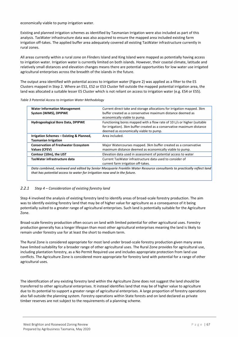
West Brighton and Rosewood Zoning Review P a g e | 67
Prepared by Agribusiness Tasmania, May 2020
economically viable to pump irrigation water. Existing and planned irrigation schemes as identified by Tasmanian Irrigation were also included as part of this analysis. TasWater infrastructure data was also acquired to ensure the mapped area included existing farm irrigation off-takes. The applied buffer area adequately covered all existing TasWater infrastructure currently in rural zones. All areas currently within a rural zone on Flinders Island and King Island were mapped as potentially having access to irrigation water. Irrigation water is currently limited on both islands. However, their coastal climate, latitude and relatively small distances and elevation changes means there are potential opportunities for low water use irrigated agricultural enterprises across the breadth of the islands in the future. The output area identified with potential access to irrigation water (Figure 2) was applied as a filter to the ES Clusters mapped in Step 2. Where an ES1, ES2 or ES3 Cluster fell outside the mapped potential irrigation area, the land was allocated a suitable lesser ES Cluster which is not reliant on access to irrigation water (e.g. ES4 or ES5).
Table 3 Potential Access to Irrigation Water Methodology
Water Information Management System (WIMS), DPIPWE
Current direct take and storage allocations for irrigation mapped. 3km buffer created as a conservative maximum distance deemed as economically viable to pump.
Hydrogeological Bore Data, DPIPWE Functioning bores mapped with a flow rate of 10 L/s or higher (suitable for irrigation). 3km buffer created as a conservative maximum distance deemed as economically viable to pump.
Irrigation Schemes – Existing & Planned, Tasmanian Irrigation
Area included.
Conservation of Freshwater Ecosystem Values (CFEV)
Major Watercourses mapped. 3km buffer created as a conservative maximum distance deemed as economically viable to pump.
Contour (10m), the LIST Elevation data used in assessment of potential access to water
TasWater infrastructure data Current TasWater infrastructure data used to consider of current farm irrigation off-takes.
Data combined, reviewed and edited by Senior Macquarie Franklin Water Resource consultants to practically reflect land that has potential access to water for irrigation now and in the future.
2.2.1 Step 4 – Consideration of existing forestry land Step 4 involved the analysis of existing forestry land to identify areas of broad-scale forestry production. The aim was to identify existing forestry land that may be of higher value for agriculture as a consequence of it being potentially suited to a greater range of agricultural enterprises. Such land is potentially suitable for the Agriculture Zone. Broad-scale forestry production often occurs on land with limited potential for other agricultural uses. Forestry production generally has a longer lifespan than most other agricultural enterprises meaning the land is likely to remain under forestry use for at least the short to medium term. The Rural Zone is considered appropriate for most land under broad-scale forestry production given many areas have limited suitability for a broader range of other agricultural uses. The Rural Zone provides for agricultural use, including plantation forestry, as a No Permit Required use and includes appropriate protection from land use conflicts. The Agriculture Zone is considered more appropriate for forestry land with potential for a range of other agricultural uses. The identification of any existing forestry land within the Agriculture Zone does not suggest the land should be transferred to other agricultural enterprises. It instead identifies land that may be of higher value to agriculture due to its potential to support a greater range of agricultural enterprises. A large proportion of forestry operations also fall outside the planning system. Forestry operations within State forests and on land declared as private timber reserves are not subject to the requirements of a planning scheme.

West Brighton and Rosewood Zoning Review P a g e | 68
Prepared by Agribusiness Tasmania, May 2020
For the purposes of Step 4, the ES Cluster mapping was overlayed with land mapped as:
• plantation hardwood or plantation softwood in the ‘Forest Group’ mapping layer on the LIST; and
• under the authority of Forestry Tasmania in the ‘Authority Land’ mapping layer on the LIST, which included all land within the Permanent Timber Production Zone. Areas where the ES Cluster mapping overlapped with any of the above mapped forestry land were further analysed. Forestry land was identified as potentially suitable for the Agriculture Zone if it overlapped with:
• areas mapped as either ES1, ES2 or ES3 Clusters; or
• the ES Cluster mapping and the land capability classification was in the range of 1 to 4.
No land currently within the Permanent Timber Production Zone was included in the final mapping data.
Table 4 Consideration of existing forestry land
Dataset Used Data and Assumptions
Forest Group dataset, the LIST Existing hardwood and softwood plantations mapped
Authority Land dataset, the LIST Existing land under the authority of Forestry Tasmania, which includes all land within the Permanent Timber Production Zone.
Enterprise Suitability Clusters, Agricultural Land Mapping Project
Where overlap occurred with ‘high value’ Enterprise Suitability Clusters ES1-3, land included as potentially suitable for the Agriculture Zone.
Land Capability, 1:100,000, DPIPWE Where overlap occurred with land capability Class 1-4, land included as potentially suitable for the Agriculture Zone.
The mapping produced through Steps 1 to 4 created the Potential Agricultural Land Initial Analysis mapping layer (Mapping Layer 1) in Figure 3.

West Brighton and Rosewood Zoning Review P a g e | 69
Prepared by Agribusiness Tasmania, May 2020
Figure 1 Agricultural land mapping project study area

West Brighton and Rosewood Zoning Review P a g e | 70
Prepared by Agribusiness Tasmania, May 2020
Figure 2 Potential access to irrigation water

West Brighton and Rosewood Zoning Review P a g e | 71
Prepared by Agribusiness Tasmania, May 2020
2.2.5 Step 5 – Allocation of potential agricultural land to cadastre The initial analysis of potential agricultural land was allocated to cadastre data. Smoothing of the mapping was
Figure 3 Potential agricultural land – initial analysis (Mapping Layer 1)

West Brighton and Rosewood Zoning Review P a g e | 72
Prepared by Agribusiness Tasmania, May 2020
undertaken in an effort to refine data into a more user-friendly planning tool by aligning the mapping to cadastre
boundaries where appropriate. Where a title contained greater than 50% of land mapped in Mapping Layer 1, the entire
title was mapped as potentially suitable for the Agricultural Zone. Titles with areas less than 50% mapped in Mapping
Layer 1 were further analysed by Senior Agricultural Consultants for potential inclusion, taking into consideration the
areas of mapped ES Clusters.
2.2.6 Step 6 – Potential constraints analysis Step 6 involved an analysis of potential constraints for agricultural use on the titles mapped under Step 5. The analysis was undertaken to identify titles where agricultural use may be constrained due to the high capital value of the title, impact of isolation from other agricultural land, and the proximity of conflicting land use. The potential constraints analysis was not meant to provide a comprehensive analysis of all factors that may contribute to constraining agricultural uses from occurring on the land. It is not possible to achieve this at a statewide level and many factors would be dependent on the agricultural enterprise, the characteristics of the operations, and the locational circumstances. It was also considered unnecessary to analyse all potential constraints for the purposes of developing a strategic planning mapping tool for the identification of the future agricultural potential of the land. The potential constraints analysis did not exclude any titles from the mapping data. Instead the analysis aimed to highlight titles or areas that may require further investigation by local planning authorities in strategically applying the Agriculture Zone. The constraints analysis may be useful for local planning authorities in identifying individual titles or clusters of titles where agricultural use may be significantly constrained. This aims to provide additional guidance on whether the land is suitable for the Agriculture Zone. The mapping of titles as ‘potentially constrained’ does not in itself indicate or justify an alternate zoning to the Agriculture Zone for that title. Further investigation should be undertaken to determine its suitability. The constraints analysis involved assessment against three criteria as outlined below and in Figure 4, with the approach of criteria 1 providing the first filter, criteria 2 the next and criteria 3 providing the final filter in identifying titles that may be constrained for agricultural use. Criteria 1 – Is the title size a potential constraint for agricultural use? A conservative approach was taken to identify minimum threshold title sizes that could potentially sustain a standalone agricultural enterprise. These were identified for each ES Cluster as shown in Figure 4. The thresholds identified for Criteria 1 were determined by utilising models based on Australian Bureau of Agricultural and Resource Economics and Sciences (ABARES), DPIPWE gross margins, DairyTas, and Holmes & Sackett data, and determining typical values for estimated value of agricultural operations (EVAO). It is acknowledged there is a high degree of disagreement amongst experts on determining potential minimum areas that are able to sustain the various agricultural enterprises. The minimum areas will depend on a number of factors including the efficiencies of the operator, the type of agricultural enterprises, technology and markets. These factors will also change overtime. Farmers are also likely to incorporate a number of different agricultural or other enterprises in order to maintain a sustainable business. Nevertheless, it was considered important to establish a suitable indicator for titles requiring further analysis of potential constraints. A title that is below the specified size threshold does not necessarily mean there are constraints to agriculture occurring on the title. Smaller titles are, and can be, used in a variety of ways for viable agricultural uses. The purpose of Criteria 1 is to narrow down the analysis to those titles that may be more susceptible to constraints. Smaller titles have a greater potential to become unviable for agricultural use as a consequence of being more susceptible to constraints caused by isolation from other agricultural land or fettering by conflicting land uses. The agricultural use of some smaller titles may also be cost prohibitive if its capital value is excessive. Criteria 1 provided the first filter in identifying titles that may be constrained for agricultural use. These titles were then considered against additional criteria to identify those that may be constrained by:
• economic barriers, in that the title is of higher capital value which may inhibit the land being purchased or used for agricultural purposes (Criteria 2A);

West Brighton and Rosewood Zoning Review P a g e | 73
Prepared by Agribusiness Tasmania, May 2020
• physical barriers, in that the surrounding land is potentially unsuitable or unviable for agriculture (Criteria 2B); or
• land use conflicts created by proximity to residential development of adjoining land which causes agricultural use on the title to be confined or restrained (Criteria 3).
Criteria 2 – Are there potential constraints for the title being used or amalgamated with adjoining agricultural land? Criteria 2 consisted of two components to further analyse the smaller titles identified in Criteria 1. Criteria 2A considered the capital value of the title and Criteria 2B considered the land surrounding the title. For Criteria 2A, capital value data from the Valuer General was applied to the titles and a capital value per hectare was determined. Titles with a capital value greater than a conservative value of $50,000/ha was identified as a potential economic constraint for purchasing and amalgamating the land with neighbouring agricultural land. Small titles with a high capital value per hectare can indicate that a high proportion of the value of the title relates to
physical improvements such as buildings, structures and other fixtures. The high capital values can often indicate the
presence of a dwelling on the title. The identification of such titles can also indicate the presence of ‘residential nodes’,
or clusters of smaller titles that are largely residential in nature with the current rural zones.
Titles with a capital value of greater than $50,000/ha were further considered against Criteria 3. Those with a capital value of less than $50,000/ha were considered against Criteria 2B. For Criteria 2B, land surrounding the title was considered to determine whether the title was adjoining other agricultural land. Small titles may be compromised by having limited connectivity with other unconstrained agricultural land. Titles that were not adjoining a title above the Criteria 1 size thresholds or with a capital value of less than $50,000/ha were identified and considered against Criteria 3. Criteria 3 – Is residential development potentially constraining agriculture land? Criteria 3 identified whether any of the titles were adjoining:
• a current Interim Planning Scheme General Residential Zone, Low Density Residential Zone, Rural Living Zone or Village Zone; or
• a Residential Zone, Low Density Residential Zone, Rural Residential Zone or Village Zone under the Flinders Planning Scheme 2000.
This analysis further aimed to identify any potential constraints due to potential land use conflicts from adjoining residential development in designated residential zones in addition to any potential constraints identified in Criteria 2A or 2B. A 25m buffer was applied around the titles to compensate for any zoning anomalies, such as a zone boundary being aligned to the centre line of a road instead of the cadastre boundary. This was a common occurrence in Interim Planning Schemes where the zone boundary corresponded with a road. The analysis against Criteria 3 did not include the consideration of any constraints caused by clusters of smaller titles (or ‘residential nodes’) within current rural zones. While such clusters may create land use conflicts, their impact can be difficult to analyse. Some of these titles may be owned or occupied in conjunction with surrounding farms. The potential impact differs to that potentially caused by proximity to a residential zone, as this land has been identified strategically for residential use and development and therefore has greater potential to impact on adjoining agricultural operations. Analysis against all three criteria allocated the titles into four categories as per Table 5.

West Brighton and Rosewood Zoning Review P a g e | 74
Prepared by Agribusiness Tasmania, May 2020
The constraints analysis, in conjunction with the mapping produced in the preceding steps, produced the Land Potentially Suitable for Agriculture Zone mapping layer (Mapping Layer 2) (Figure 5 and Figure 6).
Table 5 Results on the constraints analysis
Unconstrained Potentially Constrained (Criteria 2A)
Potentially Constrained (Criteria 2B)
Potentially Constrained (Criteria 3)
− an area greater than the Criteria 1 size thresholds; or
− an area less than the Criteria 1 thresholds, but adjoining another title with an area greater than the Criteria 1 size thresholds and a capital value of less than $50,000/ha.
− an area less than the Criteria 1 size thresholds;
− a capital value of greater than $50,000/ha; and
− not adjoining a residential zone.
− an area less than the Criteria 1 size thresholds;
− a capital value of less than $50,000/ha;
− not adjoining a title with an area greater than the Criteria 1 size thresholds; and
− not adjoining a residential zone.
− an area less than the Criteria 1 size thresholds;
− a capital value of less than $50,000/ha, or not adjoining a title with an area greater than the Criteria 1 size thresholds; and
− adjoining a residential zone.

West Brighton and Rosewood Zoning Review P a g e | 75
Prepared by Agribusiness Tasmania, December 2019
Figure 5 Land potentially suitable for the Agriculture Zone (Mapping Layer 2)

West Brighton and Rosewood Zoning Review P a g e | 76
Prepared by Agribusiness Tasmania, December 2019
Figure 6 Distribution of land potentially suitable for the Agriculture Zone (Mapping Layer 2) within northern region between Deloraine and Westbury

West Brighton and Rosewood Zoning Review P a g e | 77
Prepared by Agribusiness Tasmania, December 2019
3.0 What mapping has been produced from the project? The Agricultural Land Mapping Project has produced two mapping layers that are available on the Land Information System Tasmania’s website (the LIST). These mapping layers are: 1. Potential Agricultural Land Initial Analysis (Mapping Layer 1) This represents the land identified and mapped through the initial analysis up to Step 4 in the above methodology. A total of 21,781 square km has been mapped as potential agricultural land as part of the initial analysis. 2. Land Potentially Suitable for Agriculture Zone (Mapping Layer 2) This represents the refined mapping produced through all steps in the methodology and includes the titles mapped as part of the constraints analysis in Step 6. This layer includes:
• Unconstrained agricultural land - 20,164 square km
• Potentially Constrained agricultural land (Criteria 2A) - 245 square km
• Potentially Constrained agricultural land (Criteria 2B) – 689 square km
• Potentially Constrained (Criteria 3) - 107 square km 3.1 How should the mapping be used? The mapping is to be used by local planning authorities as a guide for the spatial application of the Agriculture Zone through their Local Provisions Schedules. The mapping may also provide guidance to the Tasmanian Planning Commission in assessing the spatial application of the Agriculture Zone in the draft Local Provisions Schedules prepared by planning authorities. Despite the sophisticated methodology, the mapping is not intended to be a definitive strategic land use planning tool as it is predominantly a desktop analysis and has only focussed on assessing the agricultural potential of the land. Local planning authorities will need to utilise this data in conjunction with a range of other data sets and information sources in making strategic land use planning decisions about some of the areas identified. The following guidelines should be considered in using the mapping to apply the Agriculture Zone in the Local Provisions Schedules: 1. The spatial application of the Agriculture Zone should be based on the land identified in the Land Potentially
Suitable for Agriculture Zone mapping layer while also having regard to:
(a) any agricultural land analysis or mapping undertaken at a local or regional level for part of the municipal area which:
(i) incorporates more recent or detailed analysis or mapping;
(ii) better aligns with on-ground features; or
(iii) addresses any anomalies or inaccuracies in the Land Potentially Suitable for Agriculture Zone mapping layer, and where appropriate, may be demonstrated in a report by a suitably qualified person, and is consistent with the relevant regional land use strategy, or supported by more detailed local strategic analysis consistent with the relevant regional land use strategy and endorsed by the relevant council;
(b) any other relevant data sets published on the LIST; and
(c) any other strategic planning undertaken at a local or regional level consistent with the relevant regional land use strategy or supported by more detailed local strategic analysis consistent with the relevant regional land use strategy and endorsed by the relevant council.
2. Land within an interim planning scheme Significant Agriculture Zone should be included in the Agriculture Zone
considered for an alternate zoning under 6. 3. Titles highlighted as Potentially Constrained Criteria 2A, 2B or 3 may require further investigation as to their
suitability for inclusion within the Agriculture Zone, having regard to:
(a) existing land uses on the title and surrounding land;
(b) whether the title is isolated from other agricultural land;

West Brighton and Rosewood Zoning Review P a g e | 78
Prepared by Agribusiness Tasmania, December 2019
(c) current ownership and whether the land is utilised in conjunction with other agricultural land;
(d) the agricultural potential of the land; and
(e) any analysis or mapping undertaken at a local or regional level consistent with the relevant regional land use strategy or supported by more detailed local strategic analysis consistent with the relevant regional land use strategy and endorsed by the relevant council.
4. The Potential Agricultural Land Initial Analysis mapping layer may assist in making judgements on the spatial application of Agriculture Zone, including, but not limited to:
(a) any titles that have or have not been included in the Land Potential Suitable for the Agriculture Zone mapping layer, including titles that are surrounded by land mapped as part of the layer;
(b) any titles highlighted as Potentially Constrained Criteria 2A, 2B or 3;
(c) outlying titles that are either included or excluded within the Land Potential Suitable for the Agriculture Zone mapping layer; and
(d) larger titles or those with extensive areas of native vegetation cover. 5. Titles may be split-zoned to align with areas potentially suitable for agriculture or where agriculture is
constrained. This may be appropriate for some larger titles. 6. Land identified in the Land Potentially Suitable for Agriculture Zone mapping layer may be considered for
alternate zoning if:
(a) local or regional strategic analysis has identified or justifies the need for an alternate zoning consistent with the relevant regional land use strategy, or supported by more detailed local strategic analysis consistent with the relevant regional land use strategy and endorsed by the relevant council;
(b) for the identification and protection of a strategically important naturally occurring resource which require an alternate zoning;
(c) for the identification and protection of significant natural values which require an alternate zoning;
(d) for the identification, provision or protection of strategically important uses that require an alternate zone; or
(e) it can be demonstrated that:
(i) the land has limited or no potential for agricultural use and is not integral to the management of a larger farm holding that will be within the Agriculture Zone;
(ii) there are significant constraints to agricultural use occurring on the land; or
(iii) the Agriculture Zone is otherwise not appropriate for the land. 7. Land not identified in the Land Potentially Suitable for Agriculture Zone mapping layer may be considered for
inclusion within the Agriculture Zone if:
(a) local or regional strategic analysis has identified the land as appropriate for the Agriculture Zone consistent with the relevant regional land use strategy, or supported by more detailed local strategic analysis consistent with the relevant regional land use strategy and endorsed by the relevant council;
(b) the land has similar characteristics to land mapped as suitable for the Agriculture Zone or forms part of a larger area of land used in conjunction with land mapped as suitable for the Agriculture Zone;
(c) it can be demonstrated that the Agriculture Zone is appropriate for the land based on its significance for agricultural use; or
(d) it addresses any anomalies or inaccuracies in the Land Potentially Suitable for Agriculture Zone mapping layer, and
having regard to the extent of the land identified in the Potential Agricultural Land Initial Analysis mapping layer.

West Brighton and Rosewood Zoning Review P a g e | 79
Prepared by Agribusiness Tasmania, December 2019
Appendix G: Agriculture in Tasmania
A key economic driver
Agriculture is a vitally important activity right across the state of Tasmania. As urban settlement expands, the interaction of urban and rural activities will be one of the most important planning issues affecting these areas in the future.
Primary production is a major creator of wealth and employment in the state. Too often, the significant contribution of agricultural producers is overlooked as urban development moves into traditional farming areas. In many cases, the value of farming activities is seen merely in terms of what the land would be worth when turned over to residential subdivision.
Tasmanian agriculture is one of the state’s key economic drivers. Primary industry output is worth more than $2.7 billion a year at farm gate and employs around one in six of every working Tasmanians.
These figures clearly confirm the importance of the sector as an economic driver for the economy and demonstrate that agriculture is a more significant contributor to the Tasmanian economy than in any other state. While Tasmania has struggled economically over recent years, agriculture has been a showcase of the economic potential that this state has to offer.
Concerns around food security have grown in recent years, with food price spikes focusing attention on rising food demand and how this will be met. Institutions such as the Food and Agriculture Organization of the United Nations (FAO) and the International Food Policy Research Institute (IFPRI) have published projections which indicate that world food demand may increase by 70 per cent by 2050.
To fulfil this growing global demand for food, and to meet the state government’s aim of doubling the value of food production by 2050, planning for the growth of Tasmania’s agricultural industries is essential.
Agriculture increasing in value
Tasmanian agriculture grew significantly in value in 2017/18. Performance was strong across most sectors, with favourable seasonal conditions, good production and high prices for many commodities.
The following data is sourced from the 2017/18 Agrifood Scorecard produced by the Tasmanian Department of Primary Industries, Parks, Water and Environment.
According to these figures, the total gross value of agriculture grew by 9.1% to $1.60 billion, of which food agriculture comprised 83.8%. The gross value of seafood production grew by 12.8% to $1.07 billion. Gross food revenue to Tasmania was $7.42 billion including net food revenue of $6.48 billion.
The major food sector indicators also hit record levels:
• The gross farm gate value of agrifood production increased by 10.6%, to $2.7 billion
• The value of processed food production increased by 11.2%, to $4.6 billion • The value of overseas food exports increased by 22.5%, to $740 million
• Net sales of Tasmanian food to overseas and interstate markets totalled $3.58 billion
The gross value of irrigated production increased from $540 million in 2006/07 to $980 million in 2017/18, and its contribution to total agricultural gross value increased from 56.0% to 61.1% over the same period.
In Southern Tasmania, agricultural production contributes over $300 million to the State’s economy. Whilst
the region has negligible prime agricultural land and its contribution to the State’s overall production is
somewhat less than the other two regions, it is nevertheless a significant contributor to the regional and
local economy, with an increasing focus on low-volume, high-value production. It is also particularly
important to the social makeup of some local communities.
There is no data on the value of agriculture in the study area.

West Brighton and Rosewood Zoning Review P a g e | 80
Prepared by Agribusiness Tasmania, December 2019
The following charts provide detail at a state-wide level.

West Brighton and Rosewood Zoning Review P a g e | 81
Prepared by Agribusiness Tasmania, December 2019

West Brighton and Rosewood Zoning Review P a g e | 82
Prepared by Agribusiness Tasmania, December 2019
Appendix H: Potential agricultural activities in study area
Agricultural activities highlighted in columns 2 and 3 could potentially be successfully undertaken within
the study area.
PLANT PRODUCTION
Forestry
Native and plantation forestry Softwood production
Environmental forest plantation
Other forest production
Cropping Cereals Barley
Buckwheat
Bird seed
Maize
Millet and panicum
Oats
Rice
Sorghum
Triticale
Wheat
Beverage and spice crops Cocoa
Coffee
Hops
Tea
Ginger
Pepper
Saffron
Hay and silage Hay
Cereal legume mixtures
Cereal crops cut for hay
Fodder
Forage sorghum
Other crops cut for hay
Lucerne
Pastures cut for hay
Oil seeds Canola – rapeseed
Essential oil crops
Flaxseed – linseed, linola
Mustard
Oil poppies
Peanuts
Pyrethrum
Safflower
Sesame
Soybeans
Sunflower
Medicinal Crops Medicinal cannabis
Alkaloid poppies Pulses Chickpeas
Field beans and peas
Field peas
Lupins
Vetches
Pasture seed
Other Aloe vera, jojoba Bamboo
Cotton
Industrial hemp and jute
Sugar
Tobacco

West Brighton and Rosewood Zoning Review P a g e | 83
Prepared by Agribusiness Tasmania, December 2019
Perennial horticulture
Tree fruits Apples
Apricots
Avocadoes
Babacos
Bananas
Carambolas
Cherries
Coconut
Custard apples
Dates
Feijoa – pineapple guava
Figs
Guavas
Jackfruit
Longans
Loquats
Lychees
Mangoes
Nashi pears
Nectarines
Other
Pawpaws – papaya
Peaches
Pears
Pepinos
Persimmons
Plums and prunes
Quinces
Rambutans
Tamarillo
Olives
Tree nuts Almonds
Brazil nuts
Cashews
Chestnuts
Hazelnuts – filberts, cobnuts
Macadamias
Pecan nuts
Pistachios
Walnuts
Chokos
Vine fruits Cucumbers
Gherkins
Melons – watermelon, rockmelon, cantaloupe
honeydew melon
Passionfruit
Shrub nuts, fruits and berries Blackberries
Blackcurrants
Blueberries
Boysenberries
Cranberries
Gooseberries
Kiwifruit
Loganberries
Pineapples Raspberries
Redcurrants
Rosella
Strawberries

West Brighton and Rosewood Zoning Review P a g e | 84
Prepared by Agribusiness Tasmania, December 2019
Perennial vegetables and herbs
Arrowroot
Asparagus
Chicory
Fennel – aniseed, dill
Rhubarb
Citrus
Grapefruit
Kumquat
Lemons
Limes
Mandarins
Oranges
Tangelos
Grapes Table, wine
Turf Landscaping, sporting
Floriculture Flowers and foliage Seasonal horticulture Seasonal nuts
Seasonal Floriculture Flowers and bulbs Seasonal vegetables and herbs
Broad beans, fava beans
French beans
Beetroot – sugar, silver, spinach, chard,
fodder beet
Bitter melon – gourd
Broccoli
Brussels sprouts
Cabbages
Chinese vegetables
Capsicums – sweet pepper
Carrots
Cauliflowers
Cucurbits – eggplants, cucumbers, zucchini
aubergine
Garlic
Herbs and micro herbs
Kumara
Leeks
Lettuce
Marrows and squashes
Mini vegetables
Okra
Onions
Parsley
Parsnips
Peas – garden pea
Potatoes, sweet potatoes
Pumpkins – squash, cattle pumpkin
Radishes
Silverbeet, kale and spinach
Snowpeas
Spring onions, shallots
Swedes
Sweetcorns – maize, corn
Tomatoes
Truffles
Turnips
Vegetable seeds
Intensive horticulture Protected crops eg crops under shade cloth or netting, on raised beds or in containers
Controlled environments eg glasshouses, greenhouses, polytunnels, mushroom sheds, hydroponics

West Brighton and Rosewood Zoning Review P a g e | 85
Prepared by Agribusiness Tasmania, December 2019
ANIMAL PRODUCTION
Grazing - native vegetation
Native pasture Exotic pasture
Sheep
Beef
Grazing - modified pasture
Woody fodder plants Pasture legumes / grass mixtures Pasture legumes/ grass mixtures/sown grasses
Lucerne planted as forage
Pasture legumes
Pasture seed, Lucerne
Perennial grasses/Lucerne mixtures
Annual grasses /Lucerne mixtures
Intensive animal husbandry Dairy Milk, dairy products
Cattle feedlots Meat cattle
Sheep feedlots Meat sheep
Poultry
Chicken eggs
Chicken meat
Ducks
Emus
Geese
Ostriches
Turkeys
Piggeries
Aquaculture Crocodiles
Fish farming
Prawn farming
Offshore caged
Offshore longline and rack
Horses
Breeding
Racing
Recreational
Stockyards / saleyards
Other
Alpacas and llamas
Beekeeping
Cat breeding
Deer
Dog breeding
Goats – meat, milk, fleece
Rabbits - – meat, fur
Source: adapted from ABARES, Commodities included in agricultural activity groupings
https://www.agriculture.gov.au/abares/research-topics/agricultural-commodities

West Brighton and Rosewood Zoning Review P a g e | 86
Prepared by Agribusiness Tasmania, March 2019
Appendix I: Questionnaire for semi-structured interviews
Introduction:
Hi, I’m <Interviewer Name> from RDS Partners (who are working with Jan Davis from Agribusiness Tasmania)
As you are aware, we have been engaged by Brighton Council to help determine the most appropriate zoning
of the land in the West Brighton and Rosewood areas.
One part of this zoning review, is to engage with stakeholders to
1. discuss the agricultural potential of the land; and
2. discuss how they see it being developed in the future.
You have been identified as a key stakeholder for us to engage with.
<Email key stakeholder these objectives with the note on ethics and privacy>
The overall objective of this review, which we’ve emailed to you earlier, is:
1. to provide recommendations to Council for the most suitable zoning of the land under the Tasmanian
Planning Scheme Framework;
2. to provide recommendations for any suitable specific planning scheme provisions, or policy
documents, that may assist in enabling single dwellings to be approved and developed in manner that
does not unreasonably conflict with, or fetter, agricultural uses, especially established agricultural
uses; and
3. to provide advice about what information should be requested to address the discretionary use
standard for residential use on agricultural land (that is, Standard 21.3.1 P4 in the Agriculture Zone in
the State Planning Provisions, see p215 of 493).
A note about ethics and privacy:
<Email key stakeholder this note to read about ethics and privacy and indicate that you will ask for verbal
consent prior to conducting phone interview>
Before we start the phone interview, we will seek your verbal consent to conduct this interview. Please read the
following couple of points regarding ethics and data management.
We work to the Australasian Evaluation Society code of ethics for evaluation. This means that we:
• ensure compliance with the principles and practices of ensuring informed consent, adhering to the
Australian privacy principles
• store all electronic data in the RDS Partners server, protected by passwords and accessible only to staff
named for the purposes of the project
• delete data held in our server within four (4) weeks of Brighton Council accepting our final report.
Guidance to interviewers:
The questions are provided to guide the interview process - not to constrain it.
While using the guide is a good discipline, the interviewer is the best judge to determine what
needs changing and what questions need including in the process of interview.
Each stakeholder will bring different perspectives to the review - and we seek to explore those
unique insights.
Please make sure that all interviews notes are passed on to Ray Murphy
[email protected] (mobile 0400 296 655).

West Brighton and Rosewood Zoning Review P a g e | 87
Prepared by Agribusiness Tasmania, March 2019
A copy of the AES Guidelines for the ethical conduct of evaluations is available from the Interviewer if
requested.
Before we start this interview, we wish to gain your consent to conduct this interview.
Have you read and considered the email about ethics and privacy that was sent to you earlier? Do you agree
to this interview with RDS Partners regarding the Brighton Zoning Review with
Interviewer Name………………………………………………………………………………………………………………….
I do / do not agree to this interview
(please cross out option that does not apply).
Stakeholder Name………………………………………………………………………………………………………………….
Interviewer Signature………………………………………………………. Date………………………………………….
A: About the stakeholder
1. Can you please tell me a bit about yourself and your interest in this Zoning Review?
2. Would you say that you have an interest in land use and zoning within the whole of Brighton, or just the
West Brighton and Rosewood areas? (Is that both West Brighton and Rosewood, or just one of these
areas?)
Circle
All Brighton Municipality
West Brighton
Rosewood
3. And are you mainly just interested in what happens with agricultural and rural land in Brighton, or all land
use and zoning in the municipality?
Circle
Agricultural and Rural land only
All land use and zoning
B: Agricultural potential of the land
1. In your opinion, what do you think is the best use of land within the West Brighton / Rosewood area?
(Note: The areas to ask about will be guided by previous responses) Why?
2. How would you describe the agricultural potential of the land?
3. What would need to happen to improve the agricultural potential of the land?
4. What activities would reduce the agricultural potential of the land?

West Brighton and Rosewood Zoning Review P a g e | 88
Prepared by Agribusiness Tasmania, March 2019
C: Individual and community perceptions
1. In your opinion, what are the main issues that need to be considered in this zoning review in West
Brighton and Rosewood? Why?
2. What works well with existing land use and zoning? Why?
3. What hasn’t worked well? Why?
D: Future development of the land
1. In your opinion, what factors will change over the next 5 to 10 years that might influence the best use of
land within the West Brighton / Rosewood area?
What makes you say that?
2. What about any changes in the next 20 to 50 years?
3. Given what you’ve just told me, what approaches would you suggest for how these future needs might
be delivered over time?
E: Snowball question – other stakeholders
As part of this review we would like to talk to other people who can provide relevant input.
Can you suggest anyone else we should talk to? (and their contact details?)
F: Conclusion
That concludes our phone interview. Thank you very much for your time and insights.
The next part of this stakeholder consultation process is for us to hold a community meeting in October to
engage with community stakeholders:
1. to discuss the agricultural potential of the land; and
2. to discuss how they see it being developed in the future.
Following the community meeting, we will review all the information we have collected and provide a report
and recommendations to Brighton Council.
Council will then consider the recommendations and make a resolution at a formal Council Meeting.
Any resolution will be a separate decision of the Brighton Council!
Please feel free to us if you have any further questions.
Thanks.

West Brighton and Rosewood Zoning Review P a g e | 89
Prepared by Agribusiness Tasmania, March 2019
Appendix J: Stakeholder forum agenda
West Brighton Stakeholder Workshop
Brighton Bowls Club, 5.00 – 6.00pm, 29th October 2019
5.00pm Introduction and Welcome: David
• Background to state-wide Tasmanian Planning Scheme Framework
• New zones and transitioning
• Brighton’s process
5.15pm Jan – project outline
The overall objectives of this process are to provide:
4. recommendations to Council for the most suitable zoning of the land under the
Tasmanian Planning Scheme Framework;
5. recommendations for any suitable specific planning scheme provisions, or policy
documents, that may assist in enabling single dwellings to be approved and
developed in manner that does not unreasonably conflict with, or fetter, agricultural
uses, especially established agricultural uses; and
6. advice about what information should be requested to address the discretionary use
standard for residential use on agricultural land.
5.25pm Ray – stakeholder overview
One part of this zoning review, is to engage with stakeholders to
3. discuss the agricultural potential of the land; and
4. discuss how you see it being developed in the future.
5.30pm Ray/Jan – engaged conversation
Agricultural potential of the land
• In your opinion, what do you think is the best use of land within the Rosewood area? Why?
• How would you describe the agricultural potential of the land?
• What would need to happen to improve the agricultural potential of the land?
• What activities would reduce the agricultural potential of the land?
Individual and community perceptions
• In your opinion, what are the main issues that need to be considered in this zoning review in
Rosewood? Why?
• What works well with existing land use and zoning? Why?
• What hasn’t worked well? Why?
Future development of the land
• In your opinion, what factors will change over the next 5 to 10 years that might influence the
best use of land within the West Brighton area? What makes you say that?
5.55pm Jan – next steps and close

West Brighton and Rosewood Zoning Review P a g e | 90
Prepared by Agribusiness Tasmania, March 2019
Appendix K: Stakeholder feedback summary
Key stakeholders for one-on-one interviews were identified by the Brighton Council.
Stakeholders to be interviewed were initially contacted by letter from the Brighton Council informing
them that they would be contacted for interview. Each stakeholder was then contacted by
Agribusiness Tasmania/RDS Partners to explain the interview process, invite them to participate in a
30-45 min phone interview and provide them with background material about the purpose of the
overall project and the interview component of the project.
Phone interviews were guided by as set of semi-structured questions. However, as each stakeholder
brings a different perspective to the review - and we sought to explore those unique insights – the
questions were used only as a guide. The interviewer provided the judge during the interview to
determine what questions need including in the process of interview.
All stakeholders were informed that the interview would be conducted according to the Australasian
Evaluation Society code of ethics for evaluation and their verbal consent to participate in the interview
was obtained prior to commencement of formal questioning.
Nine stakeholder interviews were completed between 17 September and 14 October 2019.
About the key stakeholders
Key stakeholders were initially invited to tell the interviewer a bit about themselves and their interest
in this Zoning Review.
Land use and crops grown
Stakeholders noted the following present (and past) land uses:
• vineyard (riesling, pinot, chardonnay, pinot gris) and wine production
• olive grove and olive oil production
• seedlings and potted flowers
• oats wheat and barley – seed crops
• lucerne
• sheep (pure Merino flock; Poll Dorset cross) and cattle
• mulberries, apricots, cherry plums, raspberries, walnuts, quince, plums, pears, almonds, nashi pears, nectarines
• dairy farms (historically)
• field tomatoes
• potatoes and peas
• mixed fruit trees
• peony roses, paprika, white asparagus
• equestrian and harness horse training
• receptions centre
• a metal working business
• residences
People and housing
Most key stakeholders either currently lived on the relevant land or expressed an intention to build a
dwelling on the land for their future residence.
Several people indicated that they intended to build additional dwellings for immediate family
members where landholdings were made up of several parcels of land. Many of the key stakeholders
had a generational connection to the land – with several landowner being related.

West Brighton and Rosewood Zoning Review P a g e | 91
Prepared by Agribusiness Tasmania, March 2019
In addition to any income from agricultural production, many stakeholders either had an additional
(main) off-farm income source or were retired/approaching retirement.
The vast majority of those interviewed indicated that they intended to continue to live in the area
under review.
Stakeholder interest in land use and zoning
There was generally a broad interest among key stakeholders in land use and zoning throughout the
whole of the Brighton Municipality - not just the two focus areas of West Brighton and Rosewood –
and that planning and zoning decisions need to be consistent across the entire municipality.
Planning needed to be holistic and there is a need to look at agricultural land use in Brighton as a
whole, especially the overall value of agriculture to the area. Some respondents noted that the overall
‘feel of the place’ is important, particularly as this may influence the suitability of other activities in
the future. One person considered this review to be a great case study for planning in the area.
Most stakeholders were not just interested in the agricultural and rural land use in Brighton but were
interested in what happens in all land use and zoning in the municipality. However, some participants
were only interested in agricultural and rural land use.
Notwithstanding the above views, some stakeholders were mainly only interested in land use and
zoning in the area where they owned land.
Agricultural potential of the land
Key stakeholders expressed a great diversity of opinions regarding the agricultural potential of the
land.
Some people said that the land was definitely good for agriculture, with good soil, geology, access to
some water and a good location. Some described the climate a being great for agriculture and that it
didn’t get cold like some other close by places – although some others commented on the presence
of frost requiring screening for crop protection!
There were some comments regarding previous zoning of much of the area as ‘intensive agricultural’
or ‘significant agriculture’ as not accurately reflecting the actual status of most of the land in the focus
areas. Several people noted the high level of patchiness of land capability within a relatively small
area, with some areas of sandy loam that are quite good for agricultural purposes but many other
areas that are quite rocky and stony.
One person noted that the state agricultural mapping project classification did not correctly reflect
the current cadastre.
There was a general view that the majority of the current landholdings were not of sufficient size or
land capability to support a viable farm unit on their own – and that they would mainly be used as a
‘hobby farm’ to top-up the landowners main income.
Many people spoke about having a small agricultural or rural endeavour such as some fruit trees,
grapevines, cattle or sheep, horses, vegetables or cut flowers. In most cases, people either already has
a residential dwelling on their land or would like to have a dwelling to support these activities.
Several people noted that they felt the current mix of land use was about right and that it should stay
as it is with some paddocks, livestock and rural vistas.
In contrast, one stakeholder opined that people should be encouraged to farm on small blocks,
suggesting that with good planning these could be productive and sustainable. The Netherlands was
an example of successful horticultural production and export that could be emulated in Brighton.

West Brighton and Rosewood Zoning Review P a g e | 92
Prepared by Agribusiness Tasmania, March 2019
Access to water was seen as the main limiting factor to improved agricultural production. Many people
noted that it is a dry climate and that only having TasWater (West Brighton) was a major restriction.
There were some suggestions that accessing water from Boyer pulp mill or a recycling scheme was
enhance the agricultural potential, but some thought the cost of this would be prohibitive.
Urban encroachment, further subdivision, inappropriately located dwellings and poor land
management activities (by ‘rural residential-type’ owners) were all viewed as potentially reducing the
agricultural potential of the land. Excessive water extraction from the Jordan River was noted as a
potential activity that would have a negative impact.
Some key stakeholders questioned that external agricultural assessments of the land undertaken to
support development applications – suggesting that the agricultural potential could be over- or under-
stated depending on the landholder’s needs.
Main issues that need to be considered in this zoning review
There was a general consensus that the main issue that needed to be considered in the zoning review
– and was driving the review in the first place – was the desire of people who do not currently have a
house on their land to build one. A perceived lack of consistency with planning approvals from council
– that it was said often did not follow their own planning or legal advice – was exacerbating this
situation.
Further subdivision was viewed as an issue, as it may reduce the overall agricultural potential of the
land. In addition, allowing ‘rural residential’ type developments within an historic agricultural zone
then created conflict as people in new residences were then subject to agricultural activities such as
spray drift, noise, harvesting machinery. Agricultural landowners may have also face new issues, with
dogs impacting on their stock or dust from equestrian activities.
Several stakeholders noted that getting planning certainty for an extended duration was a key issue
that needed to be addressed – as long term investment was currently comprised by zoning insecurity.
A common theme to emerge was that most people considered that a landholding of at least 5 hectares
with an appropriately located dwelling was something that was appropriate for the area and would
encourage those able to reside on their land to actively manage it. It is worth noting that several
people recognised that each landholder will have vastly different ideas as to what they may want to
do when ‘farming’ their land – not everyone will want to have intensive agriculture.
There was a general view that most people were currently neighbourly – we all talk to each other as
it is now – and that this feeling may change with further subdivision.
Past planning decisions were noted by some key stakeholders as something that needed to be
recognised and considered in the zoning review.
A rezoning and major subdivision 15-20 years ago was identified as something that has had a negative
impact, caused ongoing problems and animosity toward council.
With the letter noting change from Rural Resource to Agriculture, there seems to be some conflict and
confusion between purposes of new zone – e.g. how the change to no minimum lots size and minimum
setbacks works for protecting agricultural land? ‘Provisions seem to be written more for residential
than protecting good agricultural land’.
Setback distances were noted as an issue, suggesting that current scheme (100-200 m setback) pushes
houses into middle of properties reducing the potential agricultural use.
While some felt that fettering of agricultural land was an issue, others considered that there is no
conflict with current residences and that “another 10-12 additional houses wouldn’t change anything”.

West Brighton and Rosewood Zoning Review P a g e | 93
Prepared by Agribusiness Tasmania, March 2019
Future development of the land
The most common issue noted as impacting on future development of the land was climate change.
Some people thought that the land would become more valuable in response to agricultural land on
mainland Australia becoming less viable and people migrating to Tasmania.
New and diversified crops were seen as driving future development – and that with increasing demand
for food and different foods, improved access to water was viewed by some as being inevitable, thus
allowing for irrigated cropping. The previously noted diversity of soils in the area was seen as being
ideal for allowing a diversity of new crops. Several people noted that suitability of the area for
vineyards. This future demand was viewed as important to ensure good agricultural land was
protected now.
It was noted that the population within Brighton is rapidly growing and that there is a real advantage
of being able to supply local food.
Future land use was viewed by some as being dependant on transport development such as a new
Bridgewater Bridge and rail transport to Brighton.
Several key stakeholders noted that they didn’t think much would change with land development over
the next 5-20 years – and hoped land use would stay much the same as it was now. They considered
that there was likely to be a push for more subdivision and housing on ‘the good flat land’ and didn’t
want to see this occur, noting that there was a need to protect the current good land for new crops
and to only put houses ‘up on the hills’. ‘We have a big opportunity if it is protected, it needs to be
farmable’.
One person considered that there would be council amalgamations in the future (most likely Brighton
with Southern Midlands) and that future development needed to recognise planning consistency
between current municipalities.
It was noted that the currently school farm should be redeveloped on agricultural land.
In order to ensure that these future needs might be delivered over time, good planning and
governance from council was viewed as essential, including clear guidance on what a landowner can
and can’t do on agricultural land. Buyers need to understand what the restrictions on land are – with
an onus on developers to be truthful and buyers to conduct due diligence before they purchase new
land.
Zoning needs to be viewed with the focus of sustainability and what land is best suited to.
There was a view that planning requirement reviews should be conducted more quickly than in the
past. The council should ‘Let the planners do their job, they are the experts’ – ‘Don’t vote against the
planners’.

West Brighton and Rosewood Zoning Review P a g e | 94
Prepared by Agribusiness Tasmania, March 2019
Appendix L: Bibliography
ABARES Land use and Management Information for Australia
https://www.agriculture.gov.au/abares/aclump ABARES About my region: Tasmania https://www.agriculture.gov.au/abares/research-topics/aboutmyregion/tas#regional-overview Agrigrowth Tasmania (2018) Tasmanian Agrifood Scorecard 2017/2018 https://dpipwe.tas.gov.au/agriculture/facts-figures/tasmanian-agri-food-scorecards Armstrong, H; Squires, W; and Emtage, N (2005) The Protection of Production on Rural Lands: A review of tools and techniques for rural planning, Centre for Centre for Rural and Regional Innovation Queensland Aslin, H; Kelson, S; Smith, J; and Lesslie, R (2004) Peri-urban Landholders and Biosecurity Issues — a scoping study Bureau of Rural Sciences, Canberra Aslin H and Mazur NA (2005) Biosecurity Awareness and Peri-urban Landholders: a case study approach Bureau of Rural Sciences, Canberra. Banks, G (2000) Meeting the challenge of change in regional Australia An address to Renaissance of the Regions, Institute of Public Administration symposium Breakspear, C and Hamilton, C (2004) Getting a life - understanding the downshifting phenomenon in Australia Australia Institute Brunner, J and Glasson, J (eds) (2015) Contemporary Issues in Australian Urban and Regional Planning Routledge Press Budge, T (2005) Sponge Cities and Small Towns: a new economic partnership LaTrobe University Budge, T (2007) Securing our future food - Integrating metropolitan, economic and land use strategies Victorian Department of Health Budge, T (2013) Is Food a Missing Ingredient in Australia’s Metropolitan Planning Strategies? Food Security in Australia: Challenges and Prospects for the Future Bunker, R and Houston, P (2003) Prospects for the rural–urban fringe in Australia: observations from a brief history of the landscapes around
Sydney and Melbourne Australian Geographical Studies 41(3) Bunker, R and Holloway, D (2001)
Fringe City and Contested Countryside; Population Trends and Policy Developments around Sydney
Urban Frontiers Program, University of Western Sydney

West Brighton and Rosewood Zoning Review P a g e | 95
Prepared by Agribusiness Tasmania, March 2019
Burnley, I and Murphy, P (2004) Sea Change: movement from metropolitan to Arcadian Australia University of New South Wales Buxton, M; Carey, R; and Phelan, K (2016) The Role of Peri-Urban Land use Planning in Resilient Urban Agriculture Water Science and Technology Library, vol 72 Buxton, M; Tieman, G; Bekessy, S; Budge, T; Mercer, D; Coote, M; and Morcombe, J (2006) Change and Continuity in Peri-urban Australia, State of the Peri-urban Regions: A Review of the Literature, RMIT University, Melbourne Byron, I; Curtis, A; and MacKay J (2004) Beyond Agriculture: Changing Patterns of Farm Household Income Rural Industries Research and Development Corporation (RIRDC), Canberra
Daniels, T. (2014) The Environmental Planning Handbook for Sustainable Communities and Regions 2nd Edition Chicago: Planners Press. Daniels, T (1986) Hobby Farming in America: Rural Development or Threat to Commercial Agriculture? Journal of Rural Studies 2:1 Daniels, T (1999) When City and Country Collide: Managing Growth in The Metropolitan Fringe Island Press, Washington DC Daniels, T and Bowers, D (1997) Holding Our Ground: Protecting America's Farms and Farmlands Island Press, Washington DC Davis, J (2016) Farming on the Fringe Australian Farm Institute Journal
Edols-Meeves, M and Knox, S (2010)
Rural Residential Development – at what cost?
Centre for Coastal Management, Southern Cross University
Forster, C A (1999) Australian Cities: Continuity and Change, (2nd Edition) Oxford University Press, Oxford. Gallent, N; Andersson, J; and Bianconi, M (2006) Planning on the Edge Routledge Press
Gillespie, S and Mason, D (2003)
The Value of Agriculture in the Sydney Region
NSW Department of Agriculture
Gude, P; Hansen A J; Rasker, R; and Maxwell, B (2006)
Rates and drivers of rural residential development
US Landscape and Urban Planning Journal
Hamilton, C and Mail, E (2003) Downshifting in Australia: a sea-change in pursuit of happiness Australia Institute, Canberra

West Brighton and Rosewood Zoning Review P a g e | 96
Prepared by Agribusiness Tasmania, March 2019
Hawkins, C A (1986) The conversion of agricultural land and realities of farm economics Review of Marketing and Agricultural Economics 54:3. Hollier, C; Francis, J; and Reid, M (2004) Rural - peri-urban interface and extension National Extension Policy Forum Holz, G K; Grose, M R; Bennet, J; Corney, S (2010)
Climate Futures for Tasmania: impacts on agriculture technical report
Antarctic Climate and Ecosystems Cooperative Research Centre
Houston, P (2005) Re-valuing the fringe: some findings on the value of agricultural production in Australia’s peri-urban regions Australian Geographical Studies 43 Joseph, A E and Smit, B (1985)
Rural Residential Development and Municipal Service Provision
Canadian Journal of Rural Studies 1:4
Johnson, M; Sposito M V; Faggian, A (2018)
Land Suitability Assessment in Melbourne’s Green Wedge and Peri-Urban Areas
Centre for Regional and Rural Futures
Kelleher, F M (2001) Urban encroachment and loss of prime agricultural land Report for RIRDC Proceedings of the Australian Agronomy Conference Kelleher, F M; Chant, J; and Johnson, N L (1998a) Community expectations and perceptions of agriculture in peri-urban regions Farms Systems Research Centre, University of Western Sydney Kelleher, F M; Chant, J; and Johnson, N L (1998b) Impact of rural subdivision on agriculture Report for RIRDC Proceedings of the Australian Agronomy Conference Macquarie Franklin, Esk Mapping and GIS (2017) Agricultural Land Mapping – Identifying land suitable for inclusion within the Tasmanian Planning Scheme’s
Agricultural Zone Tasmanian Department of Justice, Public Policy Unit McKenzie F (1996) Beyond the Suburbs: population change in the major exurban regions of Australia Australian Government Publishing Service Murphy, P (2005) Sea change to Hill change: a New Equilibrium? LaTrobe University NSW Farmers Association (2006) Land use planning – discussion paper Salt, B (2001) Big Shift: welcome to the third Australian culture Hardie Grant Books, South Yarra. Sinclair, I (2010) Growth Management and Rural Land University of NSW

West Brighton and Rosewood Zoning Review P a g e | 97
Prepared by Agribusiness Tasmania, March 2019
Sinclair, I., & Bunker, R. (2012). Planning for Rural Landscapes in S. Thompson & P. Maginn (Eds.) Planning Australia - An Overview of Urban and Regional Planning (Second ed) Melbourne , Cambridge University Press.
Sinclair, I; and Bunker, R (2007)
Planning for Rural Landscapes
in Planning Australia, Cambridge University Press
Sinclair, I., Docking, A., Jarecki, S., Parker, F., & Saville, L. (2004) From the Outside Looking In - The Future of Sydney's Rural Land University of Western Sydney.
Sinclair, I; Bunker, R; and Holloway, D (2003)
Planning and Land Management n Sydney’s Fringe
Urban Frontiers Program, University of Western Sydney
Southern Tasmanian Councils Authority (2018)
Southern Tasmania Regional Land use Strategy
Spiller, M (2004) Liveable Communities: How the Commonwealth can Foster Sustainable Cities and Regions National Congress of the Planning Institute of Australia Tempest, M and Ketelaar, A (2018) Decision Tree and Guidelines for Mapping the Agriculture and Rural Zones A K Consultants, prepared for Southern Tasmanian Council Authority Thompson, S (ed) (2007) Planning Australia: An Overview of Urban and Regional Planning Melbourne, Cambridge University Press Wandl, A and Magoni, M (2017) Sustainable Planning of Peri-Urban Areas Planning Practice and Research, vol 32, 2017 Young, R (1996) Rural Subdivision Controls in NSW: Have they worked? University of New England

Key Contacts:
Jan Davis Agribusiness Tasmania
Mobile
0409 004 228
E-mail address
Ray Murphy RDS Partners
Mobile
0400 296 655
E-mail address
Ian Sinclair Edge Land Planning
Mobile
0417 047 898
E-mail address