welcome to the highway materials engineering course module … · 2016-06-15 · welcome to the...
TRANSCRIPT

Welcome to the Highway Materials Engineering Course Module B, Lesson 2: Geology and Highways. This lesson is designed to focus on the group process required for geotechnical issues in the real world, with an emphasis on the role of the materials engineer. Materials engineers should be asking questions, collaborating, and viewing other perspectives in all aspects of geotechnical work. They should know when to ask for help and ask for it when needed.
A printer‐friendly version of the lesson materials can be downloaded by selecting the paperclip icon. Only the slides for the this lesson are available.
If you need technical assistance during the training, please select the Help link in the upper right‐hand corner of the screen.

Welcome to Module B, Lesson 2: Geology and Highways. By the end of this lesson, you will be able to:
• Explain the origins of soil and rock materials; and• Describe the behavior of problem ground conditions when applied to highway construction.
During this lesson, knowledge checks are provided to test your understanding of the material presented.
This lesson will take approximately 60 minutes to complete.

First let’s talk about what geology is. Geology can be defined as a science that studies rocks, layers of soil, etc., in order to learn about the history of the Earth and its life.Additionally, you have probably heard the phrase the “geology of the area,” which is defined as: the rocks, land, processes of land formation, etc., of a particular area.
As engineers, we are interested in the geology of the project site as well as what the science of geology can tell us about rocks and soils on the site. We want to know the origin of rocks and soil and how the processes that formed them may influence their engineering properties. We will use that information to make design and construction decisions on ourtransportation project.
If you would like to learn more about the geology of your area, please click on the link for the National Geologic Map Database. To help us with that effort, let’s look at the geologic cycle.
Image description: Photo of a pick axe leaning on some rocks.

The geologic cycle consists of multiple processes; three that are instrumental to the formation of rocks and soils include the tectonic cycle, rock cycle, and hydrologic cycle.
As engineers, why are we interested in plate movement that occurs miles below the surface?
We’re interested because the movement of tectonic plates began the formation of rock that is now at the surface. In addition, some of the tectonic plates move in opposing directions. As opposing plates move past each other they can lock up, resulting in a build up of strain energy. When the plates break loose, the energy is released and a tremor or earthquake results.
Select each cycle to learn more.
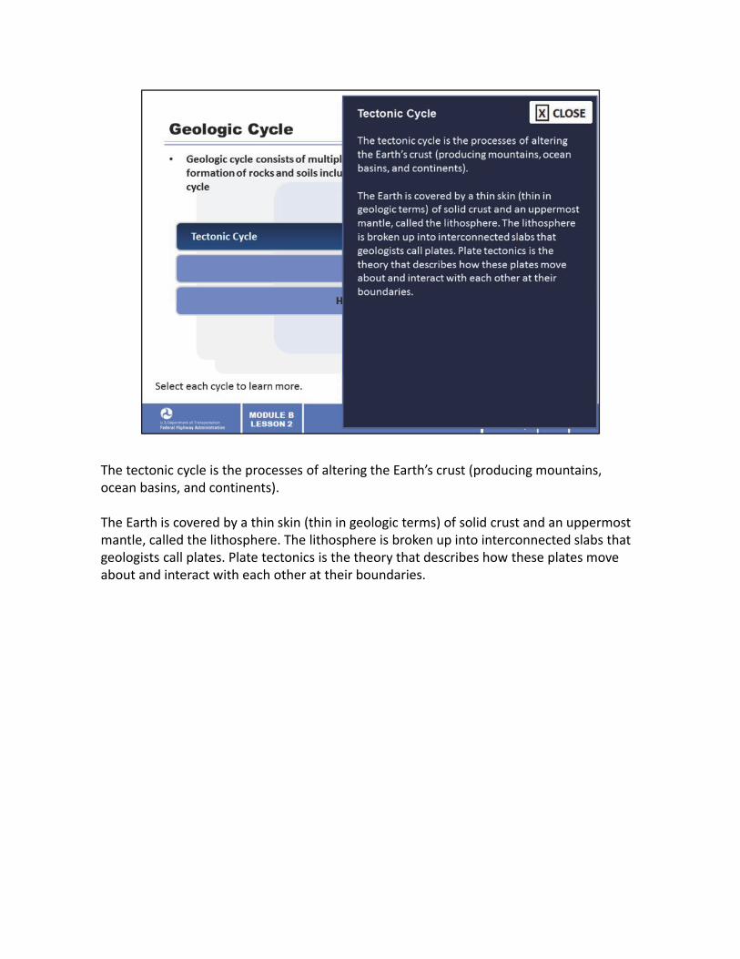
The tectonic cycle is the processes of altering the Earth’s crust (producing mountains, ocean basins, and continents).
The Earth is covered by a thin skin (thin in geologic terms) of solid crust and an uppermost mantle, called the lithosphere. The lithosphere is broken up into interconnected slabs that geologists call plates. Plate tectonics is the theory that describes how these plates move about and interact with each other at their boundaries.

The rock cycle is the formation, weathering, sedimentation, and reformation of rock.
As engineers, studying the rock cycle helps us understand the location and properties of rocks and soil.

The hydrologic cycle or water cycle, which is the movement of water over land and through the subsurface, plays an important role in geologic processes that create soil and rock, and is a major consideration in geotechnical engineering.

The movement of tectonic plates can result in earthquakes. This illustration depicts where earthquakes have occurred in the United States. Earthquakes occur in many areas of the United States and must be considered during design when appropriate.
We will discuss seismic hazards (earthquakes) in Lesson 12.
Image description: Illustration depicting where earthquakes have occurred in the United States.

The rock cycle is a fundamental concept in geology that describes the dynamic transitions through geologic time among the three main rock types: igneous, sedimentary, and metamorphic. As the diagram illustrates, each of the types of rocks are altered or destroyed when they are forced out of their equilibrium conditions. An igneous rock, such as basalt may break down and dissolve when exposed to the atmosphere, or melt as it is subducted (pulled down by movement of the tectonic plates) under an adjacent plate.
Due to the driving forces of the rock cycle, plate tectonics, and the water cycle, rocks do not remain in equilibrium and are forced to change as they encounter new environments. This illustration explains how the three rock types are related to each other and how processes change rocks from one type to another over time. Weathering is the element of the rock cycle that creates soils. Weathering can be physical or chemical. Physical weathering includes abrasion by wind, water and ice, frost action, thermal stress, pressure relief, and crystal growth. Chemical weathering is a gradual ongoing process that can change the mineralogy of the parent rock to create soils. Chemical weathering includes processes such as dissolution, carbonation, oxidation, hydrolysis, and hydration.
As engineers, we can use the rock cycle to inform us of the origin and properties of rock and soil that occur on our project site. We use many of the materials generated by the rock cycle and listed on the illustration. Sand and gravel are used throughout the construction of transportation projects. Sedimentary rocks, such as limestone, and igneous rock, such as granite, are broken up and used as riprap or crushed and used as gravel. Both igneous and sedimentary rocks are cut into stone and used as facing for bridges and retaining walls.

Weathering and erosion are key elements of the rock cycle. Let’s talk about the hydrologic cycle and the important role it plays in the weathering and erosion processes.
Looking at the left side of the illustration, find magma for Step 1 and follow the arrows around the diagram for each successive step.
Select each cycle number to learn more.
Image description: Graphic of the rock cycle.

1. Magma cools and crystallizes to form igneous rock.
Image description: Graphic of the rock cycle.
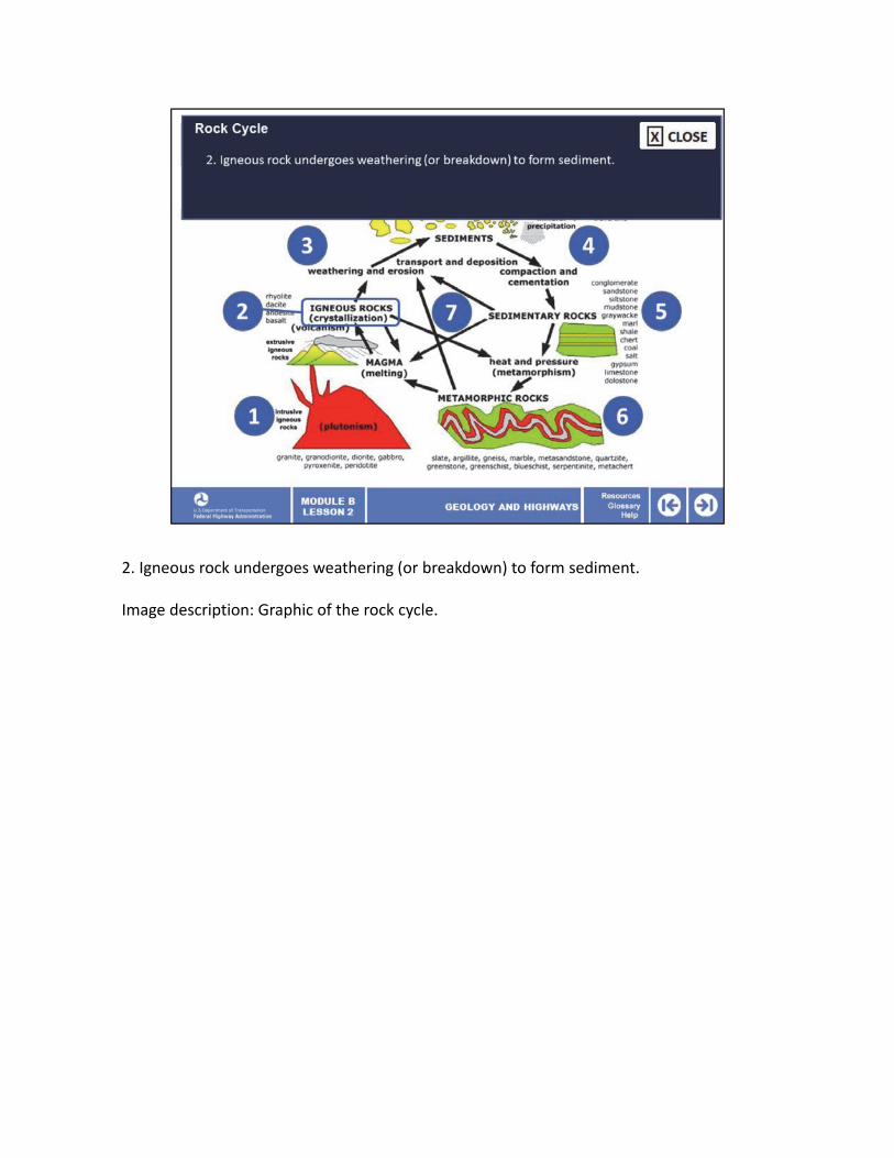
2. Igneous rock undergoes weathering (or breakdown) to form sediment.
Image description: Graphic of the rock cycle.

3. The sediment is transported and deposited somewhere (such as at the beach, in a delta, or in the deep sea).
Image description: Graphic of the rock cycle.

4. The deposited sediment undergoes lithification, the processes that turn it into a rock, which include cementation and compaction.
Image description: Graphic of the rock cycle.

5. As the sedimentary rock is buried under more and more sediment, the heat and pressure of burial cause metamorphism to occur. This transforms the sedimentary rock into a metamorphic rock.
Image description: Graphic of the rock cycle.
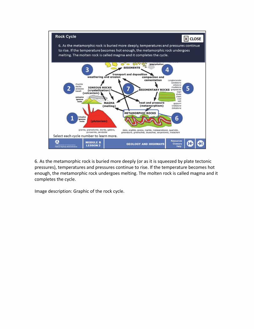
6. As the metamorphic rock is buried more deeply (or as it is squeezed by plate tectonic pressures), temperatures and pressures continue to rise. If the temperature becomes hot enough, the metamorphic rock undergoes melting. The molten rock is called magma and it completes the cycle.
Image description: Graphic of the rock cycle.

7. Now if you look at the processes happening in the middle of the diagram, note that any rock type can undergo weathering (breakdown) to form sediment, followed by transportation and deposition of the sediment. Both metamorphic and sedimentary rocks can undergo weathering.
Image description: Graphic of the rock cycle.
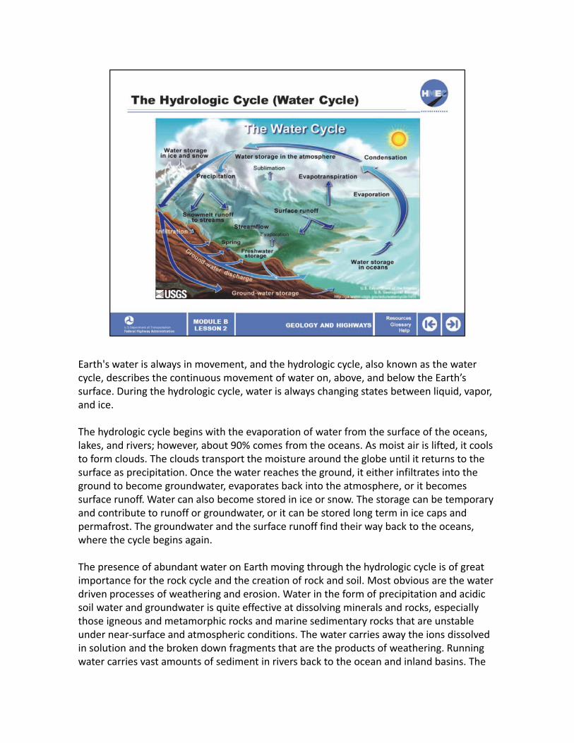
Earth's water is always in movement, and the hydrologic cycle, also known as the water cycle, describes the continuous movement of water on, above, and below the Earth’s surface. During the hydrologic cycle, water is always changing states between liquid, vapor, and ice.
The hydrologic cycle begins with the evaporation of water from the surface of the oceans, lakes, and rivers; however, about 90% comes from the oceans. As moist air is lifted, it cools to form clouds. The clouds transport the moisture around the globe until it returns to the surface as precipitation. Once the water reaches the ground, it either infiltrates into the ground to become groundwater, evaporates back into the atmosphere, or it becomes surface runoff. Water can also become stored in ice or snow. The storage can be temporary and contribute to runoff or groundwater, or it can be stored long term in ice caps and permafrost. The groundwater and the surface runoff find their way back to the oceans, where the cycle begins again.
The presence of abundant water on Earth moving through the hydrologic cycle is of great importance for the rock cycle and the creation of rock and soil. Most obvious are the water driven processes of weathering and erosion. Water in the form of precipitation and acidic soil water and groundwater is quite effective at dissolving minerals and rocks, especially those igneous and metamorphic rocks and marine sedimentary rocks that are unstable under near‐surface and atmospheric conditions. The water carries away the ions dissolved in solution and the broken down fragments that are the products of weathering. Running water carries vast amounts of sediment in rivers back to the ocean and inland basins. The

accumulated and buried sediments are converted back into rock.
Not only does water aid in the weathering and transportation of rock and materials in the rock cycle, but its presence as groundwater is a major consideration to geotechnical engineering. The presence of groundwater changes the engineering properties of soil and rock, and must be considered in design and construction of transportation projects. The moisture content of soil samples influence test results and must be monitored. The presence and movement of groundwater creates hydrostatic and seepage forces that must be considered in design. We will discuss these considerations during lessons on specific geotechnical features.
Image description: Graphic of the water cycle.

Now that we are familiar with the processes that form rocks, let’s discuss the various types. Physical geology is the study of the nature of earthen materials such as rock, soil, and groundwater. This study has developed a system and nomenclature for convenient discussion of these materials based on their origin and the processes they have undergone to reach their current state.
Rock is described with respect to its geological origin as follows:
• Igneous rocks, such as granite, diorite, and basalt, are formed by the solidification of molten materials, either at depth in the Earth's crust (intrusive) or by extrusion at the Earth's surface.• Sedimentary rocks, such as sandstone, limestone, and shale, are formed by lithification (compaction and cementation) of sedimentary soils.•Metamorphic rocks, such as quartzite, schist, and gneiss, which were originally igneous or sedimentary rocks, have been altered physically, sometimes chemically, by the application of intense heat and/or pressure at some time in their geologic history.
Select each rock type for more information.
Image description: Photo of a limestone quarry.
Image description: Photo of a granite quarry.

Limestone is an example of sedimentary rock. It is found across the United States and is quarried for aggregate, riprap, and a component of cement. The quality of limestone varies dramatically. Its unconfined compressive strength can range from a few hundred psi for limerock to over 30,000 psi for high‐quality limestone.
Limestone can provide excellent foundations for structures if the design considers actual intact strengths. However, limestone is also subject to dissolution cavities and the development of karst topography, which we will discuss later.
Image description: Photo of a limestone quarry.
Image description: Photo of a granite quarry.

Granite is an example of an igneous rock. It is found across the United States sometimes at the surface but often at greater depths. Granite is quarried as aggregate, riprap, and dimension stone. It has very high, unconfined compressive strength and durability. Granite makes excellent aggregate for concrete, asphalt, basestone, and chips.
Granite is an excellent foundation material for structure foundations because of its high strength. However, if penetration is required into the granite layer, the drilling penetration rate can be extremely slow because of its hardness. It can take several days to drill a rock socket.
Image description: Photo of a limestone quarry.
Image description: Photo of a granite quarry.

Mineral particles are formed from the decomposition of rock by weathering (the action of air, water, wind, and ice) and chemical processes. Soil consists of loosely bound mineral or unbound grains of various sizes and shapes combined with vapor and water in the pore space between the grains or particles. Soils are classified by their principal size components.
The coarse‐grained components of soil that can be distinguished visually include boulder‐, cobble‐, gravel‐, and sand‐sized particles. Naturally occurring gravels and sands are used extensively on transportation projects. Because they are relatively free draining, construction over underlying layers of coarse‐grained material is often problem free. However, layers of boulders and/or dense gravel can be problematic for construction of deep structure foundations.
Silt and clay are fine‐grained components, too fine to visually distinguish individual grains. Therefore, these fine components are identified by physical behavior. Silt in its dry state has the fineness of powdered sugar or flour. Silt usually has a floury feel when dry, and a slippery feel when wet. Silt does not bond tightly with water. Silt consists primarily of fine quartz particles formed by abrasion from wind, water, or ice.
Clay consists of submicroscopic‐size, plate‐like particles that have strong properties for bonding with water molecules. Clay minerals are typically formed over long periods of time by the gradual chemical weathering of rocks, usually silicate‐bearing, by low concentrations of carbonic acid and other diluted solvents. These solvents, usually acidic, migrate through

the weathering rock after leaching through upper weathered layers. Clay deposits may be formed in place as residual deposits in soil, but thick deposits usually are formed as the result of a secondary sedimentary deposition process after they have been eroded and transported from their original location of formation. Clay deposits are typically associated with very low‐energy depositional environments such as large lakes and marine basins.
Geotechnical engineers distinguish between silts and clays based on the plasticity properties of the soil, as measured by the soils’ Atterberg limits, which we will discuss in a later lesson.
Silt and clay are not free draining, therefore, if they are low strength and subject to consolidation, the process can take a long time and must be considered in design and construction. However, some clay layers are strong and can provide adequate support of construction of fills and structures.
Organic soil deposits were formed from the remains of plant life that were deposited under water, thus stopping the decomposition process from lack of oxygen. Organic deposits present critical foundation problems because of high compressibility and low strength.
Image description: Photo of hands filled with soil.

Now that we have identified the rock and soil types, let’s discuss the processes that develop them and the landforms where they are found. Non‐glacial landforms are either residual or transported. Glacial landforms are created by the forces of ice or water.
Soils found within the lateral boundaries of the deposit that are placed by the same depositing process should generally have similar composition and engineering characteristics. Consequently, the topography or landform produced by the deposit should have certain identifiable characteristics. This concept of landforms is a powerful tool in evaluating types of soils encountered throughout the project and for planning the subsurface exploration program. However, transportation projects often cross the lateral boundaries of geologic deposits, and, therefore, soil and rock characteristics will often vary along a project length.
Image description: Photo of a glacier in the mountains.

Residual soils develop from the surface of bedrock through weathering and chemical action. Weathering agents include rain, wind, abrasion, heat, frost action, and root growth. Soil components reflect the composition of the parent rock. Residual soils weather in place. Residual soils that develop by chemical weathering include saprolites, caliche, and decomposed granite. One residual soil developed through physical weathering is fault gouge.
Select each category for more information.

Saprolite is a soft, thoroughly decomposed and porous, highly weathered rock, often rich in clay, formed by the in‐place chemical weathering of igneous, metamorphic, or sedimentary rocks. Saprolite is especially common in humid and tropical climates. It is usually reddish brown or grayish white and contains those structures (such as cross‐stratification) that were present in the original rock from which it formed.
The Piedmont residual soils along much of the east coast are an example. The upper zone consists of completely weathered material or soil. A second intermediate zone is termed “saprolite.” This material retains the relict structure of the parent rock, although its strength resembles that of soil. The third zone is partially weathered rock with alternating seams of saprolite and weathered rock. And finally, unweathered rock, or bedrock, exists below the partly weathered rock.

Caliche generally forms when minerals leach from the upper layer of the soil and accumulate in the next layer, at depths of approximately 3–10 feet under the surface. During the leaching process, calcium carbonate, a natural cementing agent, binds other materials such as gravel, sand, clay, and silt to form caliche, which is basically a relatively thin‐layer, weak sedimentary rock. Caliche occurs worldwide, generally in arid or semiarid regions, including the western United States.
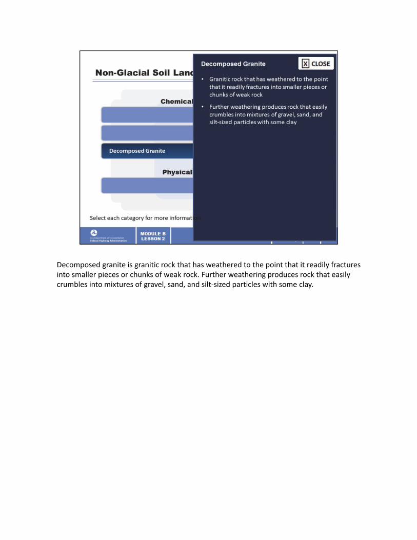
Decomposed granite is granitic rock that has weathered to the point that it readily fractures into smaller pieces or chunks of weak rock. Further weathering produces rock that easily crumbles into mixtures of gravel, sand, and silt‐sized particles with some clay.

Fault gouge is crushed and ground‐up rock produced by friction between the two sides when a fault moves. The grinding and milling that results when the two sides of the fault zone move along each other results in a material that is made of loose fragments. First, a fault breccia (coarse grain) will form, but if the grinding continues, the rock becomes fault gouge (a very small grain size). It is normally unconsolidated unless cementation took place at a later stage.
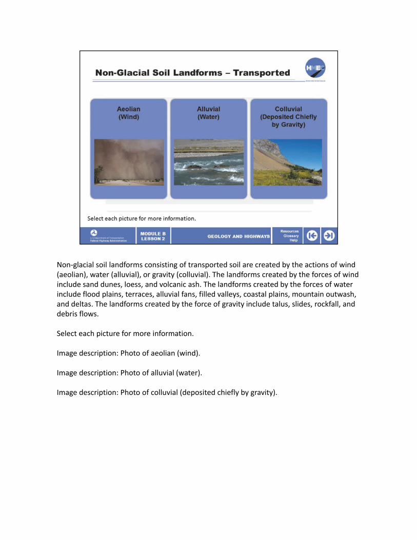
Non‐glacial soil landforms consisting of transported soil are created by the actions of wind (aeolian), water (alluvial), or gravity (colluvial). The landforms created by the forces of wind include sand dunes, loess, and volcanic ash. The landforms created by the forces of water include flood plains, terraces, alluvial fans, filled valleys, coastal plains, mountain outwash, and deltas. The landforms created by the force of gravity include talus, slides, rockfall, and debris flows.
Select each picture for more information.
Image description: Photo of aeolian (wind).
Image description: Photo of alluvial (water).
Image description: Photo of colluvial (deposited chiefly by gravity).

Wind can carry silt‐sized particles long distances. Wind‐blown silts from dried‐out glacial lake deposits in the northern United States cover large areas in the central United States. These lightly cemented silt deposits are called loess soils.
Volcanic ash of silt size can also be carried long distances by wind. Sand particles carried by wind near the surface of the ground form sand dunes.
Image description: Photo of aeolian (wind).
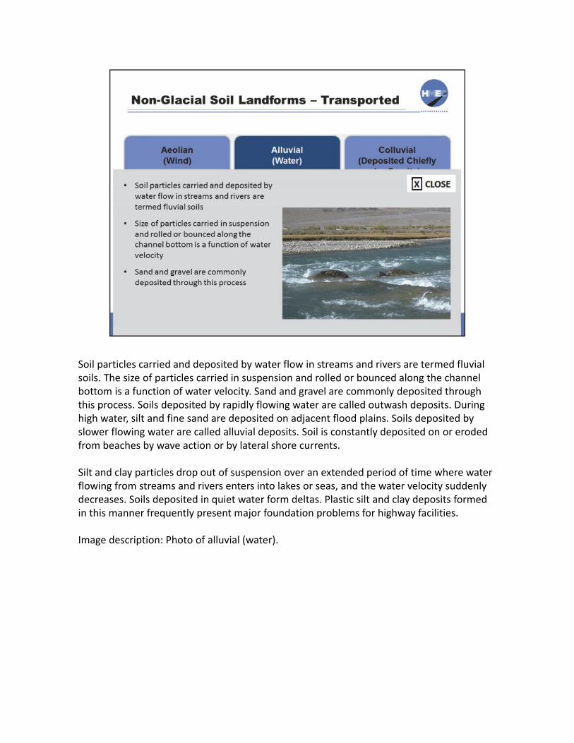
Soil particles carried and deposited by water flow in streams and rivers are termed fluvial soils. The size of particles carried in suspension and rolled or bounced along the channel bottom is a function of water velocity. Sand and gravel are commonly deposited through this process. Soils deposited by rapidly flowing water are called outwash deposits. During high water, silt and fine sand are deposited on adjacent flood plains. Soils deposited by slower flowing water are called alluvial deposits. Soil is constantly deposited on or eroded from beaches by wave action or by lateral shore currents.
Silt and clay particles drop out of suspension over an extended period of time where water flowing from streams and rivers enters into lakes or seas, and the water velocity suddenly decreases. Soils deposited in quiet water form deltas. Plastic silt and clay deposits formed in this manner frequently present major foundation problems for highway facilities.
Image description: Photo of alluvial (water).
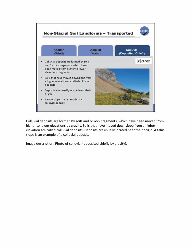
Colluvial deposits are formed by soils and or rock fragments, which have been moved from higher to lower elevations by gravity. Soils that have moved downslope from a higher elevation are called colluvial deposits. Deposits are usually located near their origin. A talus slope is an example of a colluvial deposit.
Image description: Photo of colluvial (deposited chiefly by gravity).

Loess, a wind‐blown silt that is lightly cemented, is a common earth material in western Iowa. It was blown from river floodplains and outwash plains during the Pleistocene Ice Age. The depth of the loess deposits in western Iowa can be as much as 350 feet.
As seen in this photograph, loess can stand on a near vertical face if left undisturbed. However, if loess is excavated and placed in an embankment, it is highly erodible and must be placed on an extremely flat slope. Loess is also subject to collapse, which we will discuss later in this lesson.
Reference: This photo is of a road cut in Monona County, Iowa near Preparation Canyon State Park; from the film strip by Wayne Anderson and restored by Iowa DNR Geological Survey.
Image description: Photo of a road cut in Monona County, Iowa near Preparation Canyon State Park.
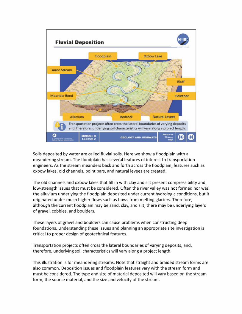
Soils deposited by water are called fluvial soils. Here we show a floodplain with a meandering stream. The floodplain has several features of interest to transportation engineers. As the stream meanders back and forth across the floodplain, features such as oxbow lakes, old channels, point bars, and natural levees are created.
The old channels and oxbow lakes that fill in with clay and silt present compressibility and low‐strength issues that must be considered. Often the river valley was not formed nor was the alluvium underlying the floodplain deposited under current hydrologic conditions, but it originated under much higher flows such as flows from melting glaciers. Therefore, although the current floodplain may be sand, clay, and silt, there may be underlying layers of gravel, cobbles, and boulders.
These layers of gravel and boulders can cause problems when constructing deep foundations. Understanding these issues and planning an appropriate site investigation is critical to proper design of geotechnical features.
Transportation projects often cross the lateral boundaries of varying deposits, and, therefore, underlying soil characteristics will vary along a project length.
This illustration is for meandering streams. Note that straight and braided stream forms are also common. Deposition issues and floodplain features vary with the stream form and must be considered. The type and size of material deposited will vary based on the stream form, the source material, and the size and velocity of the stream.

Image description: Illustration of meandering streams.

This illustration of ancient channels and meanders on the Mississippi River provides an example of what the geotechnical engineer must consider when designing a transportation project across a major river floodplain. The old channels and meanders are typically filled with low‐strength, highly compressible clays and silts.
Reference: Ancient Courses: Mississippi River Meander Belt. Cape Girardeau, MO ‐Donaldsonville, LA. Prepared by Harold N. Fisk. PhD., for the USACE in 1944.
Image description: Illustration of ancient channels and meanders on the Mississippi River.

Deltas are deposits of fine clays and silts that occur when a river flows into a body of water. This illustration of historical locations of the large deltas from the Mississippi River as it flows into the Gulf of Mexico indicates the issues that must be considered.
The geotechnical engineer must recognize that the current location of the river and delta may not be the only location that needs to be investigated when performing a site investigation. These deltaic deposits are often deep with low strength and subject to large settlement under load.
Image description: Illustration of historical locations of the large deltas from the Mississippi River as it flows into the Gulf of Mexico.

This talus slope is an example of a colluvial deposit. A talus slope is a collection of broken rock fragments at the base of mountain cliffs that has accumulated through periodic rockfall from the adjacent cliff faces.
Image description: Photo of a talus slope.

Now let’s talk about landforms created by the actions of glaciers. Climatic changes occurred millions of years ago that caused the formation of glaciers or ice sheets in present‐day Canada. Continental glaciers continued to expand until at their maximum they covered most of the northern Midwest, northeast, and northwest United States.
As they moved over the land and then receded, they created numerous landforms. Landforms deposited by the ice included moraines, till, and drumlins. Landforms deposited by water associated with the glaciers included outwash, kames, eskers, lakebeds, terraces, and deltas.

The Pleistocene glaciation began about 1.6 million years ago and, after four periods of glaciation, ended about 14,000 years ago. The glaciers would advance south during periods of glaciation and then recede to the north during what are called inter‐glacial periods. Glaciers extended as far south as Missouri and the current‐day Ohio River Valley.
Under pressure, the lower portion of ice became a flowing plastic mass that planed mountains and deepened and widened valleys. The Great Lakes are examples of lake basins that were formed by glaciers. Vast amounts of rock and soil were ground‐up, mixed together, carried south, and deposited in a compact condition. These deposits are called glacial till and consist of variable mixtures of all size soil particles including boulders.
The glaciers were several‐thousand feet thick, and the pressure they exerted on the ground consolidated the till as well as underlying material. This is an important consideration when designing geotechnical features in glaciated areas.
Image description: Illustration of a map of the world.
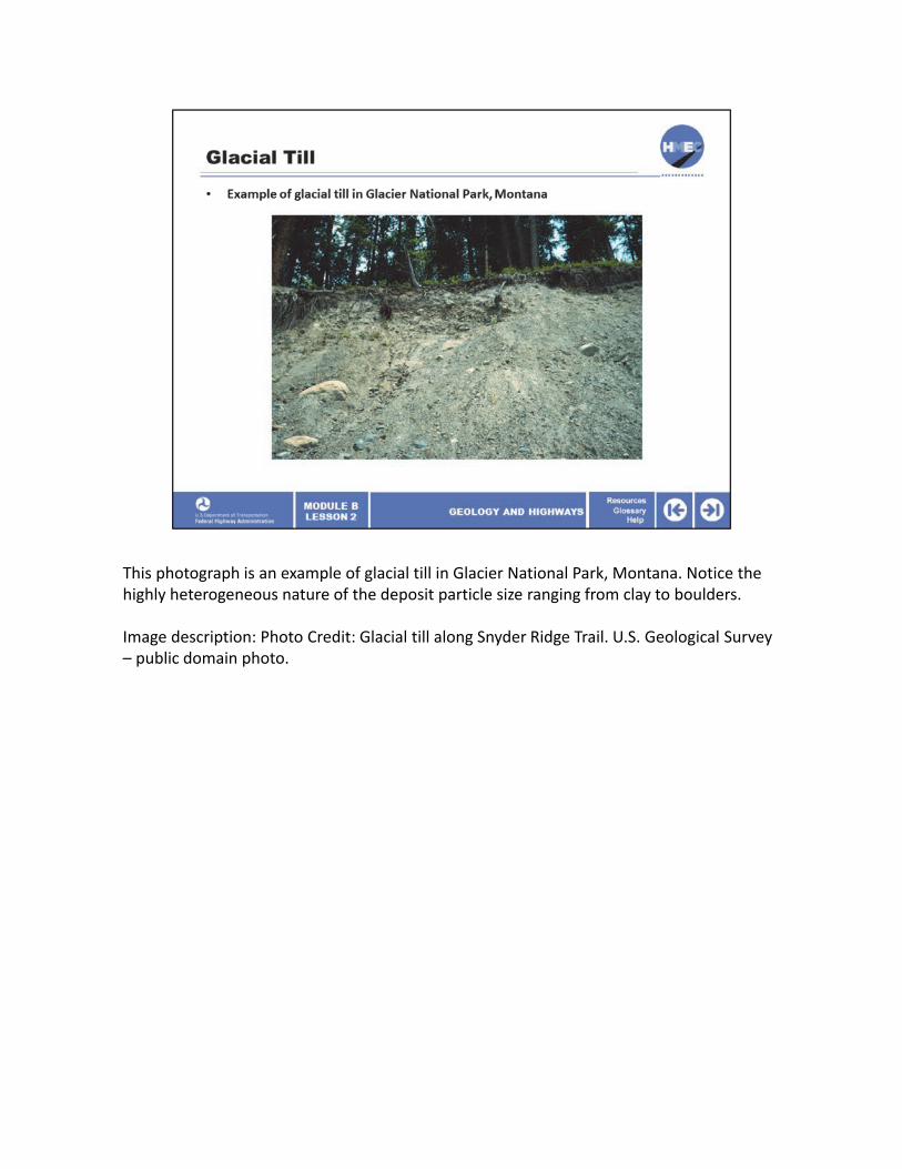
This photograph is an example of glacial till in Glacier National Park, Montana. Notice the highly heterogeneous nature of the deposit particle size ranging from clay to boulders.
Image description: Photo Credit: Glacial till along Snyder Ridge Trail. U.S. Geological Survey – public domain photo.

This photograph is an example of glacial till deposited in Iowa, during the Wisconsin glaciation period. It is visible in many Iowa road cuts. It was deposited by glacial ice and consists of poorly sorted, non‐stratified material. Since glacial till has been consolidated by thick ice, it is typically high strength and makes an excellent foundation. This exposure is near Finchford in Black Hawk County, Iowa.
Reference: Film strip by Wayne Anderson, restored by Iowa DNR Geological Survey
Image description: Photo of an example of glacial till deposited in Iowa, during the Wisconsin glaciation period.

Now that we understand the formation and properties of glacial till, let’s discuss other landforms created by the glacial ice and water as it advances and then recedes. As the glacier advances, it pushes material ahead at its front edge; as it recedes, a moraine is created. The moraine consists of till material but is unconsolidated since it was not under the thick ice. As the thick ice sheet receded, large quantities of melt water flowed south, forming outwash plains consisting of coarse gravel, sand, and silt. Large temporary lakes were also formed that are now deep clay deposits.
A kame is an irregularly shaped hill or mound composed of sand, gravel, and till that accumulates in a depression on a retreating glacier and is then deposited on the land surface with further melting of the glacier. Kames are often associated with kettles (depressions), and this is referred to as kame and kettle topography.
An esker is a long, winding ridge of stratified sand and gravel. Most eskers are thought to have formed within ice‐walled tunnels by streams which flowed within and under glaciers.
Drumlins and drumlin clusters are glacial landforms, composed primarily of glacial till. It is debated if they are erosional or depositional landforms.
Image description: Illustration of post glacial landforms.

Glacial outwash, shown here, consists of coarse gravel and cobbles.
Image description: Photo of a glacial outwash.

Kames and eskers are examples of glacial landforms.
Image description: Photo of kames and eskers.

This is a photograph of a glacially created drumlin on the Waterville Plateau in Washington State.
Image description: Photo of a glacially created drumlin on the Waterville Plateau in Washington State.

This photograph shows the contact between a glacial till overlain by the younger recessional outwash soils deposited as the glacier retreated and fluvial processes dominated the depositional environment. Outwash plains are an excellent source of sands and gravels.
Image description: Photo of the contact between a glacial till overlain by the younger recessional outwash soils deposited as the glacier retreated and fluvial processes dominated the depositional environment.

This USGS photograph shows an unusually complete, long‐term loess‐paleosol record near Elba, Nebraska; the last interglacial‐glacial cycle is represented by the Sangamon paleosol (last interglacial) and Peoria loess (last glacial). The modern soil at the top began forming at the beginning of the present interglacial period.
This photograph provides a very informative picture of features that develop with multiple glaciation periods over hundreds of thousands of years. One feature that is of particular interest to engineers constructing roadways is the paleosol layer that develops between glaciation periods. This is an ancient topsoil that formed during the interglacial period. It is typically a foot or more in thickness and is highly impermeable. It is common to have springs where the paleosol intersects the surface of the ground. Because it cuts off drainage of groundwater, this layer must be recognized and accounted for in design, or slope failures may occur.
Image description: Photo of features that develop with multiple glaciation periods over hundreds of thousands of years.

Alpine glaciers exist around the world and have been instrumental in our understanding of continental glaciation. Note that the process and landforms for alpine glaciers are the same as for continental glaciers.
Image description: Illustration of an alpine glacial system.

This is a map of the landform regions of Iowa. It is a very beneficial document when performing the terrain reconnaissance discussed in the previous lesson. Similar documents may exist for your State and should be reviewed.
Image description: A map of the landform regions of Iowa.

There are also “landforms” that are created by human activities, called human‐modified land, which might include old embankments, landfills, abandoned underground mines, dewatering activities, and deforestation. Unfortunately, human‐modified land does not provide us any indicators as to what we might find underground. The previous activities of man can also greatly affect the way soils and rocks behave. We know for sure that most of them will be problematic.
All of these features present geotechnical engineering challenges. Their identification during geotechnical site investigation can be of vital importance to the economics of the project, as well as the health and safety of the traveling public.
Select each category for more information.

The previous activities of man can also greatly affect the way soils and rocks behave. Probably the most common example is the discovery of old fills on a project site. Old fills were typically poorly compacted and may include all types of undesirable inclusions, including wood, debris, and garbage.
Image description: Photo of heavy equipment digging out an old fill.
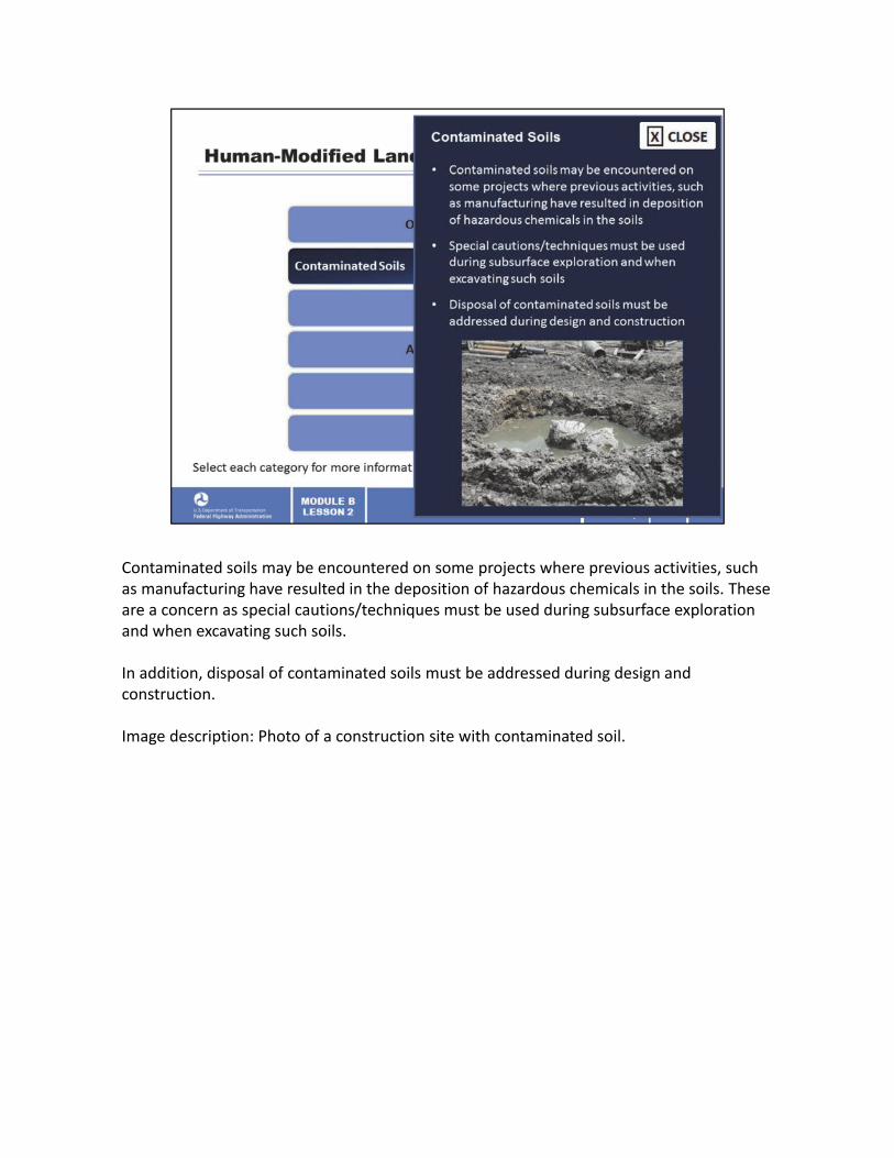
Contaminated soils may be encountered on some projects where previous activities, such as manufacturing have resulted in the deposition of hazardous chemicals in the soils. These are a concern as special cautions/techniques must be used during subsurface exploration and when excavating such soils.
In addition, disposal of contaminated soils must be addressed during design and construction.
Image description: Photo of a construction site with contaminated soil.

Landfills are unconsolidated masses of garbage, which may contain hazardous materials. They are a concern to the soil investigation effort as well as design and construction.
Image description: Photo of a landfill.

Underground mines are all over the United States. When they are abandoned and they underlie our roadways, catastrophic failures can result.
Image description: Photo of an abandoned mine safety sign.

Dewatering or lowering of the natural groundwater table will cause an increase in overburden stress (to be discussed in Lesson 6), which must be considered during design and construction of transportation projects. An example of this is ground subsidence due to pumping wells.
Image description: Photo of a collapsed road.

Deforestation, whether by natural disaster or humankind activities, will result in dramatic increases in runoff from precipitation. The increased runoff may cause flooding and mud flows, which may damage transportation facilities as well as homes, buildings, and other infrastructure.
Image description: Photo of deforestation.

The laws of soil mechanics do not apply to manmade materials such as landfills, and special treatment must be considered for such situations. We can use soil mechanics theory to predict the behavior of naturally occurring materials, but we have no theory to predict the behavior of a landfill.
Image description: Photo of a landfill.

Safety problems for travelers caused by sinkholes and slides initiated by abandoned underground mines are a growing concern as the mines in the United States deteriorate with age. Transportation agencies are faced with a potentially large number of sites that need to be addressed, as well as a lack of knowledge and experience in dealing with these sites. The potential liability that these sites present can be significant.
A 12‐foot section of Interstate Route 70 in Guernsey County, Ohio suddenly collapsed due to abandoned underground mine subsidence on March 5, 1995. This collapse resulted in near tragedy and the subsequent closure of this vital roadway for four months.
Consequently, the Interstate Technical Group on Abandoned Underground Mines was conceived. This group is composed of technically oriented individuals responsible for remediation of underground mines beneath highways in 14 States and one Canadian province. The goals of the group are to:
1) Generate and disseminate information; and 2) Obtain outside funding or cooperatively share in the costs of related mutually beneficial efforts.
Visit the FHWA Web site for more information on abandoned underground mines: http://www.fhwa.dot.gov/engineering/geotech/hazards/mine/.
Image description: Photo of a water filled sinkhole.

Let’s discuss some soils and rock that may cause problems for transportation projects. They include expansive soils, frost susceptible soils, collapsible soils, and karst terrain (sinkholes). Please note that water is necessary for these mechanisms or “problems” to occur.
Image description: Photo of a sinkhole in the middle of a road.

This map from the US Army Corp of Engineers shows the extent of expansive clay soil deposits around the United States.
Expansive soils occur across the United States. This illustration shows areas of low, medium, and highly expansive soils. Expansive soil is considered one of the most common causes of pavement distresses. Depending upon the moisture level, expansive soils will experience changes in volume due to moisture fluctuations from seasonal variations. During periods of high moisture, expansive soil will swell underneath pavement structure. Conversely, during periods of falling soil moisture, expansive soil will shrink and can result in significant deformation. These cycles of swell and/or shrinkage can also lead to pavement cracking.
The parent (source) rock for expansive soils can be igneous, such as granite or volcanic ash or clay based sedimentary rock, such as shale. As weathering breaks down the rock, clay is formed. If the clay is created in a poorly drained soils environment, highly expansive clays, such as montmorillonites are formed.
Image description: Map from the US Army Corp of Engineers shows the extent of expansive clay soil deposits around the United States.

Edge cracking of pavements can be the result of expansive soil in the subgrade. The photograph shows an example of longitudinal cracking from an expansive subgrade on a low‐volume road in Texas.
A number of treatments are available to limit damage to roadways from expansive soils. They include:
• Chemical alteration of expansive soil, such as lime stabilization, which is one of the most extensively used alterations in the subgrade.• Geogrid reinforcement, which is sometimes combined with lime treatment, is another effective method to prevent longitudinal cracking caused by the shrinkage of expansive subgrade.• Control of the subgrade moisture conditions with vertical geomembrane barriers.• Paved shoulders have proven effective as a membrane above the soil, and help maintain a near steady water content. Of course, if a crack opens between the pavement and shoulder, and roadway dips that direction, the water content could be greatly increased. So, it is paved shoulder and maintenance.
Image description: Photo of edge cracking on a road.

This graphic illustrates the frost depth across the continental United States. These frost depths in conjunction with frost‐susceptible soils (such as silts and fine sands) and water can create substantial forces on pavements and structures. In Alaska, the engineer needs to consider the tremendous forces that develop in frozen ground and permafrost areas. The design challenge with permafrost is to keep it frozen, i.e., do not let it thaw.
Image description: Graphic of frost depth across the continental United States.
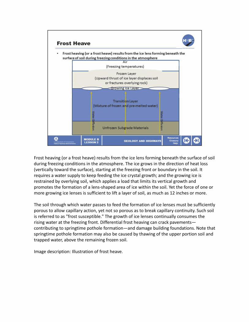
Frost heaving (or a frost heave) results from the ice lens forming beneath the surface of soil during freezing conditions in the atmosphere. The ice grows in the direction of heat loss (vertically toward the surface), starting at the freezing front or boundary in the soil. It requires a water supply to keep feeding the ice crystal growth; and the growing ice is restrained by overlying soil, which applies a load that limits its vertical growth and promotes the formation of a lens‐shaped area of ice within the soil. Yet the force of one or more growing ice lenses is sufficient to lift a layer of soil, as much as 12 inches or more.
The soil through which water passes to feed the formation of ice lenses must be sufficiently porous to allow capillary action, yet not so porous as to break capillary continuity. Such soil is referred to as "frost susceptible." The growth of ice lenses continually consumes the rising water at the freezing front. Differential frost heaving can crack pavements—contributing to springtime pothole formation—and damage building foundations. Note that springtime pothole formation may also be caused by thawing of the upper portion soil and trapped water, above the remaining frozen soil.
Image description: Illustration of frost heave.

Collapsible soils undergo a sudden decrease in volume due to the addition of water,although the majority of collapsible soils occur in wind‐blown loess deposits. Collapsible soils are associated with alluvial fans deposits in arid climates. Collapsible soils in alluvial fans have been recognized throughout the southwestern United States. The soils dry prior to subsequent deposition and do not become fully consolidated under the overburden stress. They have a loose honeycomb structure, low unit weight, and high dry strength.
Collapsible soil subgrade can have a serious impact on pavement durability and can cause problems with foundations. The soil must be identified and then removed or stabilized. Stabilization can be accomplished (depending on the depth of the deposit) by normal compaction, deep compaction, ponding, or water well injection.
Image description: Map of the United States showing loess deposits and reports of collapse in other type deposits.
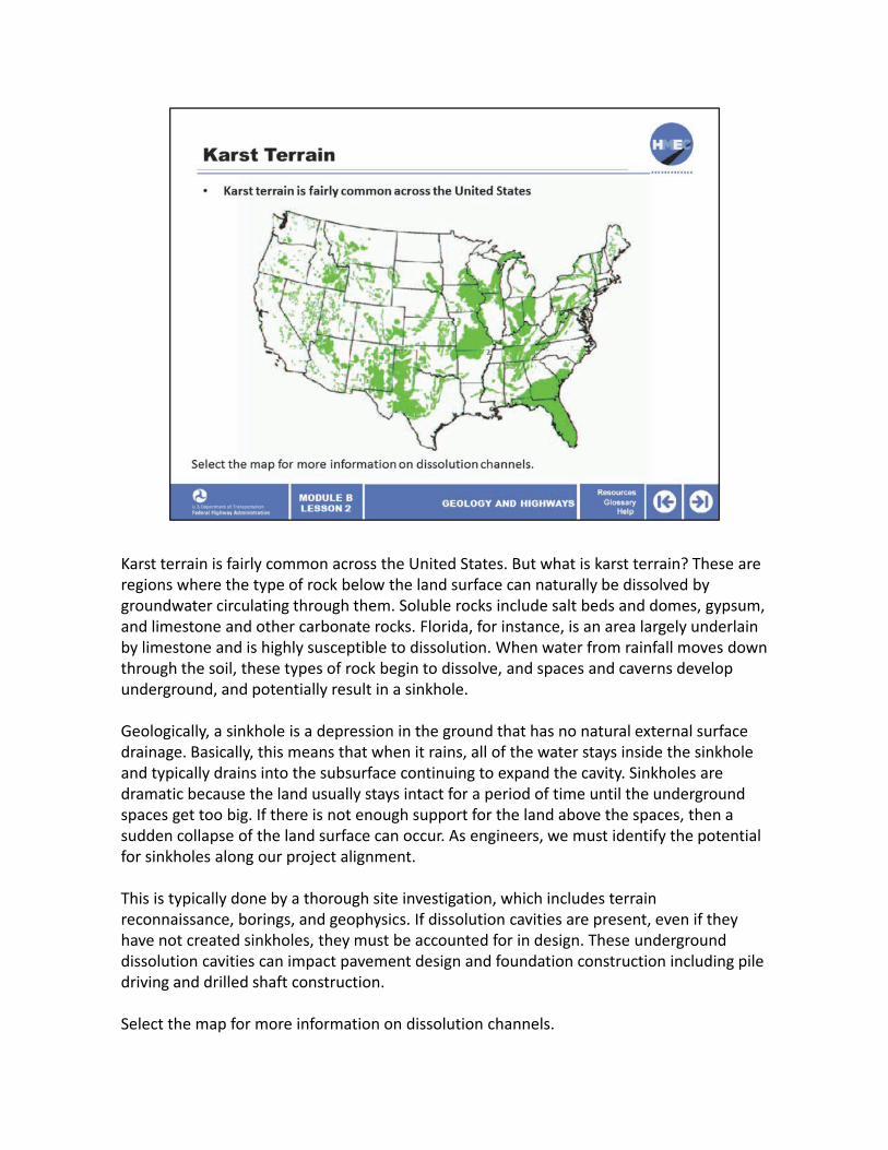
Karst terrain is fairly common across the United States. But what is karst terrain? These are regions where the type of rock below the land surface can naturally be dissolved by groundwater circulating through them. Soluble rocks include salt beds and domes, gypsum, and limestone and other carbonate rocks. Florida, for instance, is an area largely underlain by limestone and is highly susceptible to dissolution. When water from rainfall moves down through the soil, these types of rock begin to dissolve, and spaces and caverns develop underground, and potentially result in a sinkhole.
Geologically, a sinkhole is a depression in the ground that has no natural external surface drainage. Basically, this means that when it rains, all of the water stays inside the sinkhole and typically drains into the subsurface continuing to expand the cavity. Sinkholes are dramatic because the land usually stays intact for a period of time until the underground spaces get too big. If there is not enough support for the land above the spaces, then a sudden collapse of the land surface can occur. As engineers, we must identify the potential for sinkholes along our project alignment.
This is typically done by a thorough site investigation, which includes terrain reconnaissance, borings, and geophysics. If dissolution cavities are present, even if they have not created sinkholes, they must be accounted for in design. These underground dissolution cavities can impact pavement design and foundation construction including pile driving and drilled shaft construction.
Select the map for more information on dissolution channels.

Image description: Map of the United States showing karst terrain.

This photograph shows a near‐surface dissolution channel in limestone that was exposed on a side‐hill. Most are underground and cannot be seen. You can imagine the types of problems these features cause for pavements, piling, and drilled shafts. They must be identified by a thorough site investigation including borings and geophysics.
Image description: Photo of a near‐surface dissolution channel in limestone that was exposed on a side‐hill.

True or false? The rock cycle is a continuous cycle that produces all earthen materials.

The correct answer is a) True. The rock cycle is a continuous cycle over geologic time that produces the three primary rocks: igneous, sedimentary, and metamorphic, as well as all soils.

When does limestone provide a good foundation?
a) Always, limestone is an excellent material; b) Never, limestone is weak and filled with voids; c) When limestone is properly investigated and tested to determine intact properties; or d) Only when limestone is exposed at the surface so we can see there are no voids.

The correct answer is c) When limestone is properly investigated and tested to determine intact properties. Limestone strength can be highly variable and limestone can be subject to dissolution cavities. However, it can also be solid and have very high strength. Therefore, with proper investigation including borings and geophysics, along with sampling and testing, limestone can provide excellent foundations.

What are the characteristics of naturally occurring gravels?
a) Free draining; b) Good source of high quality road base; c) Dense gravel layers can cause problems when constructing deep foundations; d) Gravel can be found in outwash plains and buried under floodplains; or e) All of the above.

The correct answer is e) All of the above. Naturally occurring gravel is often a high‐quality and free‐draining material that can be used for road base, aggregate for concrete or asphalt, and surfacing for low‐volume roads. It can be found in outwash plains as well as in buried layers deposited under past hydrologic conditions. Dense gravel layers can cause problems when driving certain types of piling.

Floodplains often include old channels and meanders, what material and engineering properties can be expected in those features?
a) High strength sands and gravels; b) Low strength highly compressible silts and clays; c) High strength glacial till; or d) High quality aggregate for road base.

The correct answer is b) Low strength highly compressible silts and clays. On floodplains, the old channels and meanders are typically filled during flooding with deposits of silt and clay, which are low strength and highly compressible. Coarse materials, such as sands and gravels are deposited near the stream banks in the form of natural levees. Glacial till was deposited by glaciers over 14,000 years ago.

Name types of collapsible soils.
a) Loess and alluvial fan deposits; b) Glacial outwash deposits and glacial till;c) expansive clay and karst; or d) drumlins, eskers, and kames.

The correct answer is a) Loess and alluvial fan deposits. Loess and some alluvial fan deposits are subject to sudden and dramatic reduction in volume (collapse) with the addition of water even without an increase in load.

You have completed Module B, Lesson 2: Geology and Highways. You are now able to:
• Explain the origins of soil and rock materials; and• Describe the behavior of problem ground conditions when applied to highway construction.
Close this lesson, and return to the module curriculum to select the next lesson. To close this window, select the “X” in the upper right‐hand corner of your screen.