wausau center · the proposed modern roundabout at the intersection of grand avenue/forest...
TRANSCRIPT

MAY 2019
WAUSAU CENTER URBAN DESIGN & TRANSPORTATION MASTER PLAN

THIS PAGE INTENTIONALLY LEFT BLANK
// WAUSAU CENTER Urban Design & Transportation Master Plan 2
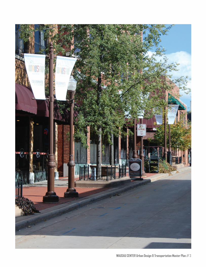
WAUSAU CENTER Urban Design & Transportation Master Plan // 3

THIS PAGE INTENTIONALLY LEFT BLANK
// WAUSAU CENTER Urban Design & Transportation Master Plan 4

WAUSAU CENTER Urban Design & Transportation Master Plan // 5
CONTENTSWausau Center Urban Master Plan ��������������������������������������������������������������������������������������������������8
Introduction �����������������������������������������������������������������������������������������������������������������������������������9
Workshops9
Community Values9
Community Outreach and Online Survey 10
Design Concepts �������������������������������������������������������������������������������������������������������������������������� 10
Modified Street Network 10
Roundabouts and Gateway Features 11
Non-Motorized Connectivity 11
Complete Streets 11
Proposed Network Modifications ��������������������������������������������������������������������������������������������������� 11
Traffic Analysis ���������������������������������������������������������������������������������������������������������������������������� 14
Street Modifications ��������������������������������������������������������������������������������������������������������������������� 16
1st Street 16
Forest Street 16
Washington Street 18
5th Street 20
Entry Sequence Modification �������������������������������������������������������������������������������������������������������� 21
1st Street/River Drive/Washington Street 21
Grand Avenue/5th Street/6th Street 22
Maintenance ��������������������������������������������������������������������������������������������������������������������������������23
Prioritization ��������������������������������������������������������������������������������������������������������������������������������25
Reinvestment and Revitalization ����������������������������������������������������������������������������������������������������26
Cost Estimates �����������������������������������������������������������������������������������������������������������������������������28
Appendix ������������������������������������������������������������������������������������������������������������������������������������� 31

THIS PAGE INTENTIONALLY LEFT BLANK
// WAUSAU CENTER Urban Design & Transportation Master Plan 6
WAUSAU CENTER Urban Design & Transportation Master Plan // 7
ACKNOWLEDGEMENTSCity of Wausau
Robert Mielke, Mayor
Christian Schock, Director- Planning, Community, and Economic Development
Brad Lenz, AICP, City Planner
Brad Sippel, AICP, Assistant Planner
Allen M. Wesolowski, P.E., City Engineer
Thomas Niksich, Project Engineer
Study Stakeholder Committee
Mark Craig, Compass PropertiesCord Buckner, Wausau Police Department and Parking DivisionJim Hellrood, Wausau Police Department and Parking DivisionAaron Ruff, Marathon County Health DepartmentBrad Karger, Marathon County AdministratorAndy Lynch, Wausau Metropolitan Planning Organization- Marathon CountyBlake Opal-Wahoske, Wausau River DistrictSam Pinzl, Marathon County Health Department
Prepared by
Toole Design 212 Third Avenue North, Suite 476 Minneapolis, MN 55401
Information contained in this document is for planning purposes and should not be used for final design of any project. All results, recommendations, concept drawings, cost opinions, and commentary contained herein are based on limited data and information, and on existing conditions that are subject to change.
// WAUSAU CENTER Urban Design & Transportation Master Plan 8
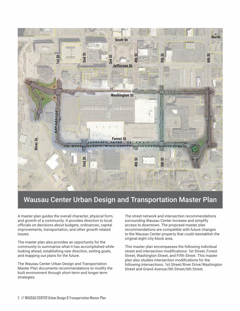
Wausau Center Urban Design and Transportation Master Plan
A master plan guides the overall character, physical form, and growth of a community. It provides direction to local officials on decisions about budgets, ordinances, capital improvements, transportation, and other growth related issues
The master plan also provides an opportunity for the community to summarize what it has accomplished while looking ahead, establishing new direction, setting goals, and mapping out plans for the future
The Wausau Center Urban Design and Transportation Master Plan documents recommendations to modify the built environment through short-term and longer-term strategies
The street network and intersection recommendations surrounding Wausau Center increase and simplify access to downtown. The proposed master plan recommendations are compatible with future changes to the Wausau Center property that could reestablish the original eight city-block area.
This master plan encompasses the following individual street and intersection modifications: 1st Street, Forest Street, Washington Street, and Fifth Street. This master plan also studies intersection modifications for the following intersections: 1st Street/River Drive/Washington Street and Grand Avenue/5th Street/6th Street
North
>
Scott St
Jefferson St
Washington St
Forest St
1st S
t
2nd
St
3rd
St
4th
St
5th
St
6th
St
Rive
r Dr
2nd
St
4th
St
5th
St

WAUSAU CENTER Urban Design & Transportation Master Plan // 9
IntroductionThe City of Wausau contracted Toole Design to help re-envision the street network surrounding Wausau Center. The objective for this study was to evaluate the circulation, traffic patterns, parking, pedestrian experience, and streetscaping of the streets around the Wausau Center, primarily focusing on Forest Street and Washington Street from 1st Street to 6th Street. Wausau Center was constructed in 1983 on land that was formerly part of the downtown street network consisting of an eight city-block area
During the master planning process, there were many opportunities for the public, stakeholders, and City staff to provide input and feedback The process culminated in a final public meeting during which there was broad consensus to move forward with the design concepts that were presented. This document summarizes the design process and public input as well as the resulting design concepts and recommendations for Wausau Center
WorkshopsThe design concepts were developed during two, four-day workshops that occurred in September and October of 2018 During week 1, the Discovery Workshop focused on:
• Field site visit to document existing conditions and a public open house meeting;
• Stakeholder interviews;
Public comments received during the Discovery Workshop
• Traffic analysis and preliminary starter concepts; and
• Pin-up and public meeting.
During week 2, the Design Workshop focused on:
• Refining preliminary starter design concepts including cross sections, photo renderings, and illustrative master plan;
• Intersection analysis and concepts; and
• Final public meeting.
Community ValuesParticipants in the public workshops, stakeholder interviews, and open studio times conveyed their perspectives about downtown Wausau. Many people recognized the potential opportunities a roadway configuration could provide in accommodating future conditions Members of the public voiced support for the efforts of City staff, private business owners, and many others who are working hard to revitalize and invest in Wausau. Participants also mentioned pride in their City and the profound sense of community that already exists among residents, staff, and business owners.
Participants spoke openly about the current conditions of downtown Wausau and voiced strong opinions about Wausau Center The current vacancies and lack of vibrancy were noted as a detractor, but the historic character of the adjacent buildings, in addition to other vibrant streetscape amenities, were identified as potential opportunities for the community to build upon
North
// WAUSAU CENTER Urban Design & Transportation Master Plan 10
Wausau Center’s current circulation patterns of one-way and two-way streets make it rather confusing to navigate downtown Wausau by walking, bicycling, and driving. The scale and complexity of gateway intersections detract from downtown Wausau’s character and can create confusion for people visiting downtown. Participants also mentioned the overwhelming amount of space in the downtown core that is either underutilized or taken up by parking.
In summary, there was resounding support for considering changes to streets surrounding Wausau Center and other key intersection locations that would positively contribute to the public realm experience of the City of Wausau
Community Outreach // Online SurveyContinual engagement was critical to keep the community and stakeholders informed of the project and to solicit additional feedback. In addition to the two workshops, the City and design team held individual stakeholder interviews, open studio times, and developed an online survey that was shared with the public. The survey provided and opportunity for people to provide feedback on project concepts if they were unable to attend in-person meetings A summary of the results from the survey is in Appendix A
Design ConceptsThis section describes the design concepts developed during the second design workshop week. The design team explored the circulation, traffic patterns, parking, pedestrian experience, and streetscaping of the streets around Wausau Center, primarily focusing on Forest Street and Washington Street from 1st Street to 6th Street While the primary focus of the study was the roadway corridors directly adjacent to the mall site, our team also reviewed the greater roadway network to get a better understanding of existing conditions
The following design principles were applied to the study area:
• Design for all users (motorist, bicyclist, pedestrian, and people with disabilities);
• Create proper sidewalk zones to accommodate all users and necessary elements (frontage zone, clear zone, furnishing/landscape zone, and curbing), and
• Build upon the existing streetscape components to create a unified sense of place for downtown Wausau.
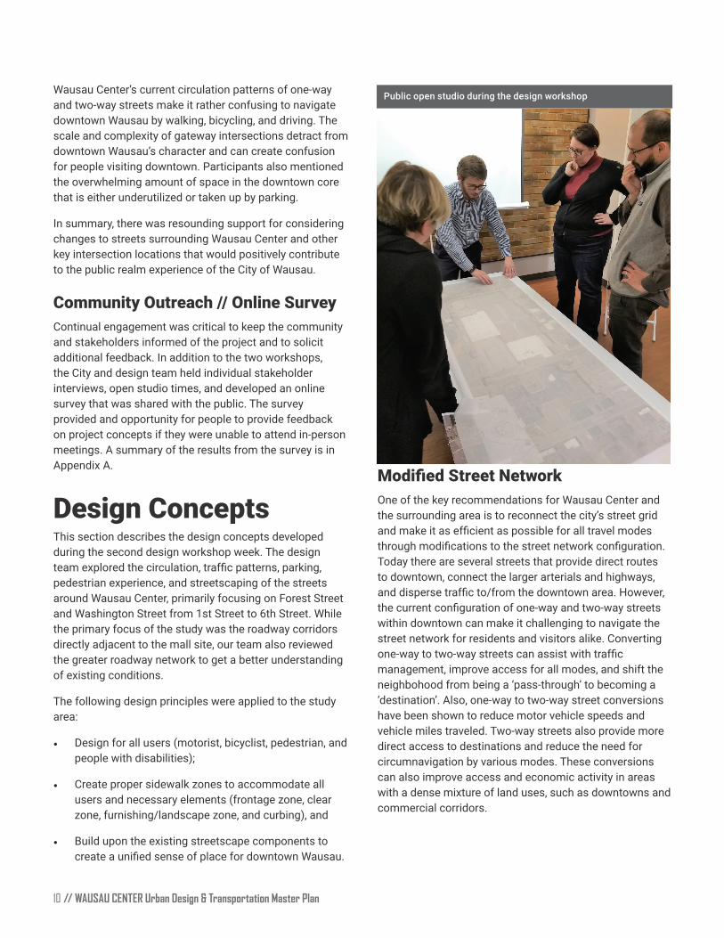
Public open studio during the design workshop
Modified Street NetworkOne of the key recommendations for Wausau Center and the surrounding area is to reconnect the city’s street grid and make it as efficient as possible for all travel modes through modifications to the street network configuration. Today there are several streets that provide direct routes to downtown, connect the larger arterials and highways, and disperse traffic to/from the downtown area. However, the current configuration of one-way and two-way streets within downtown can make it challenging to navigate the street network for residents and visitors alike. Converting one-way to two-way streets can assist with traffic management, improve access for all modes, and shift the neighbohood from being a ‘pass-through’ to becoming a ‘destination’. Also, one-way to two-way street conversions have been shown to reduce motor vehicle speeds and vehicle miles traveled. Two-way streets also provide more direct access to destinations and reduce the need for circumnavigation by various modes These conversions can also improve access and economic activity in areas with a dense mixture of land uses, such as downtowns and commercial corridors

WAUSAU CENTER Urban Design & Transportation Master Plan // 11
Roundabouts and Gateway FeaturesRoundabouts and gateway features should be considered at key locations to enhance the benefits of the proposed modified street network. A modern roundabout should be considered for the Grand Avenue/Forest Street/6th Street intersection to replace an existing awkward intersection layout and increase access into downtown. This would also provide more clear direction for visitors by defining this as an important connection within downtown Wausau. In addition, a modern roundabout would provide traffic yield at entry points, traffic deflection, and geometric curvature designed to slow the speeds of vehicles. The modern roundabout will also serve as a gateway entrance feature permitting a more direct and continuous route for users traveling to downtown Wausau.
Non-Motorized ConnectivityThe provision of a connected low-stress bikeway system can add another layer of value to the connectivity of Wausau. A low-stress bikeway refers to the idea that a network may be established that ensures bicyclists of any age or ability can comfortably bicycle on streets throughout the city. A low-stress system will reinforce access to downtown, add recreational value, and augment an already active riverfront open space. Ideally, the bikeway network would connect key land uses and open spaces, and be continuous and free from obstacles. The on-street low stress bikeways would ideally connect to the existing riverfront trail system. This effort will require significant planning and coordination between the City and other local agencies
Complete StreetsComplete Streets describes streets that comfortably accommodate all the various users of the street, with an emphasis on pedestrians, bicyclists, and transit users, as well as people of all ages and physical abilities. Those street users are more exposed and affected by the street environments than motor vehicle users. In addition, cities across the state have begun to adopt complete streets principles as they revise the circulation elements of their general plans
Balancing the needs of multiple users within limited right-of-way (ROW) space is one of the biggest challenges to developing a complete street design concept for any street The proposed design concepts for Wausau are based on the guiding principle that treatments should be developed working from the edge of the street ROW where the most vulnerable roadway users can be accommodated with shared use paths, sidewalks, tree lawn buffers, etc. and then work in toward the middle of the street where lanes should be a maximum of 11-feet wide to accommodate motor vehicle traffic. WisDOT prefers 12-feet wide travel lanes, but if an exemption to allow 11-feet wide is allowed in the future, then it is recommended to adjust the two-way bicycle facilities to 10-feet wide.
Proposed Network ModificationsTo implement the recommended one-way to two-way conversions, two complex intersections would need to be reconfigured. Two intersections were studied as part of this project; the intersection of 1st Street/River Drive/Washington Street and Grand Avenue/Forest Street/6th Street. Both intersections provide access into downtown Wausau, however each lacks vital pedestrian scale treatments for an inviting and accessible space
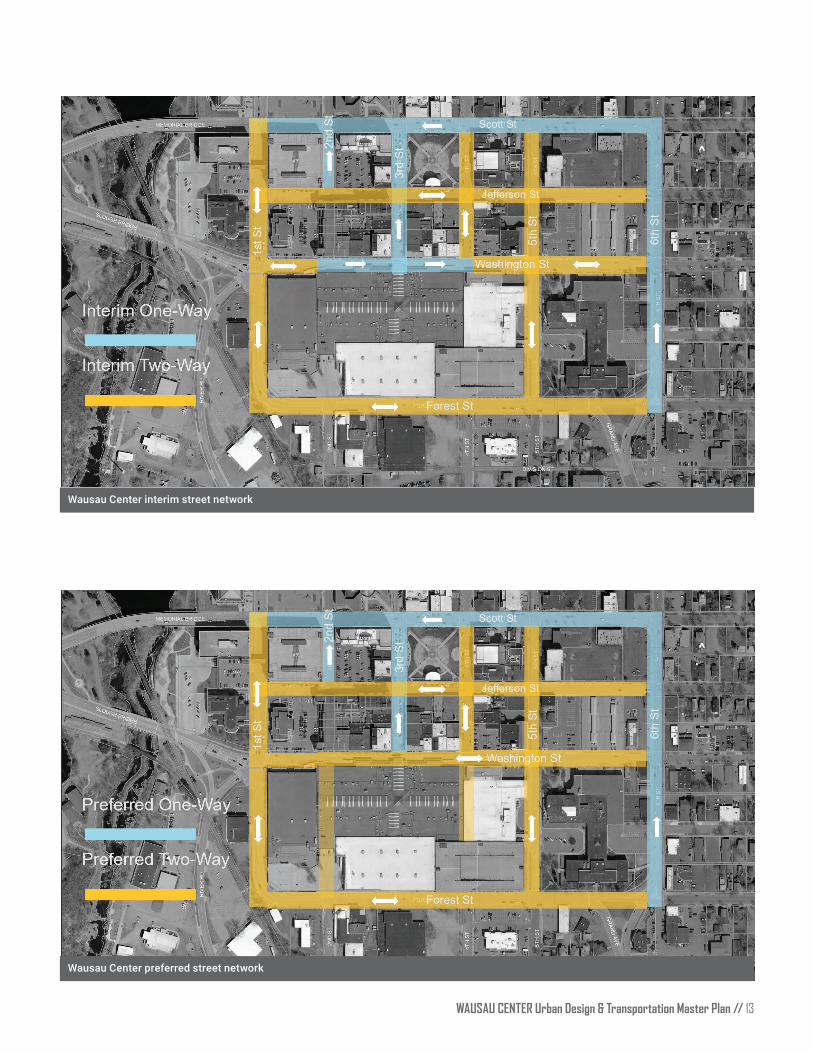
The downtown Wausau network maps identify an interim and preferred street network conversion of one-way to two-way streets. The interim network reestablishes better connectivity for all modes by a short-term strategy of converting the following streets from one-way to two-way operations:
Downtown Wausau recommended non-motorized network
// WAUSAU CENTER Urban Design & Transportation Master Plan 12
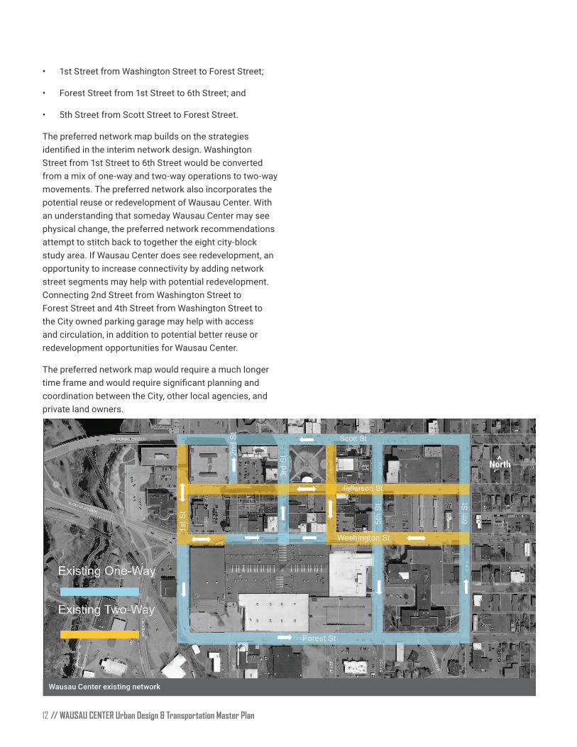
Wausau Center existing network
• 1st Street from Washington Street to Forest Street;
• Forest Street from 1st Street to 6th Street; and
• 5th Street from Scott Street to Forest Street.
The preferred network map builds on the strategies identified in the interim network design. Washington Street from 1st Street to 6th Street would be converted from a mix of one-way and two-way operations to two-way movements. The preferred network also incorporates the potential reuse or redevelopment of Wausau Center With an understanding that someday Wausau Center may see physical change, the preferred network recommendations attempt to stitch back to together the eight city-block study area. If Wausau Center does see redevelopment, an opportunity to increase connectivity by adding network street segments may help with potential redevelopment. Connecting 2nd Street from Washington Street to Forest Street and 4th Street from Washington Street to the City owned parking garage may help with access and circulation, in addition to potential better reuse or redevelopment opportunities for Wausau Center
The preferred network map would require a much longer time frame and would require significant planning and coordination between the City, other local agencies, and private land owners.
North
>
WAUSAU CENTER Urban Design & Transportation Master Plan // 13
Wausau Center interim street network
Wausau Center preferred street network
North
North
>>
// WAUSAU CENTER Urban Design & Transportation Master Plan 14
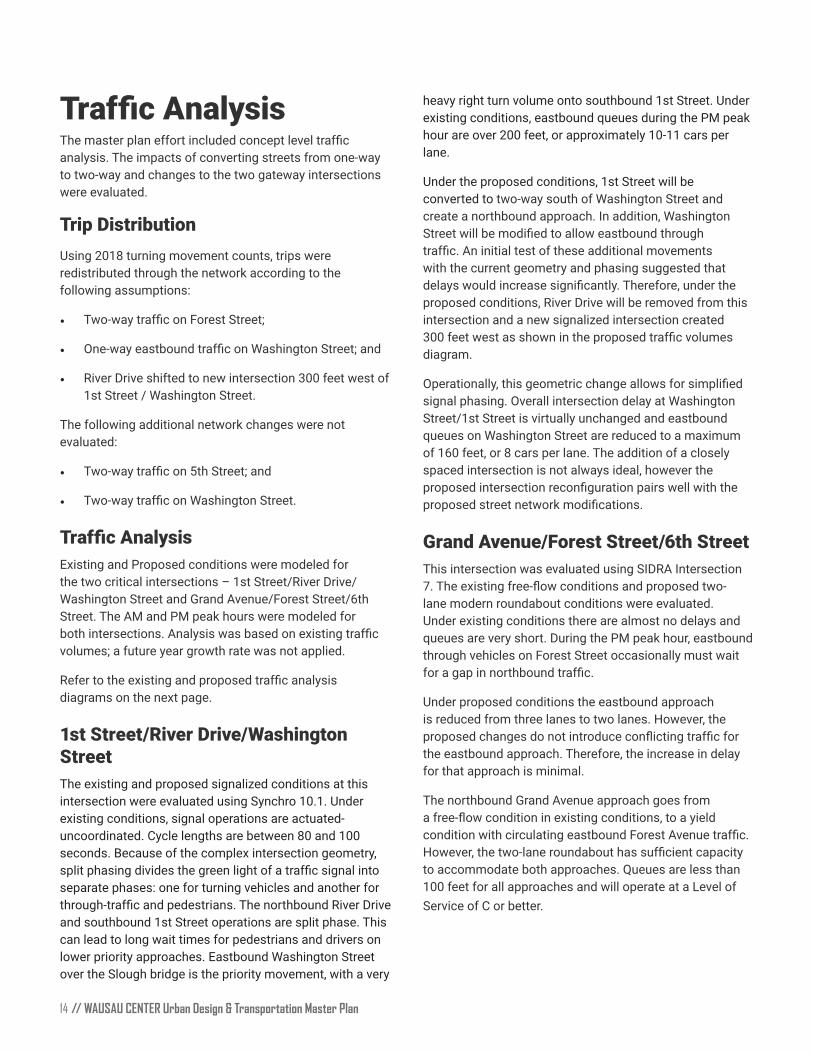
Traffic AnalysisThe master plan effort included concept level traffic analysis. The impacts of converting streets from one-way to two-way and changes to the two gateway intersections were evaluated.
Trip DistributionUsing 2018 turning movement counts, trips were redistributed through the network according to the following assumptions:
• Two-way traffic on Forest Street;
• One-way eastbound traffic on Washington Street; and
• River Drive shifted to new intersection 300 feet west of 1st Street / Washington Street
The following additional network changes were not evaluated:
• Two-way traffic on 5th Street; and
• Two-way traffic on Washington Street.
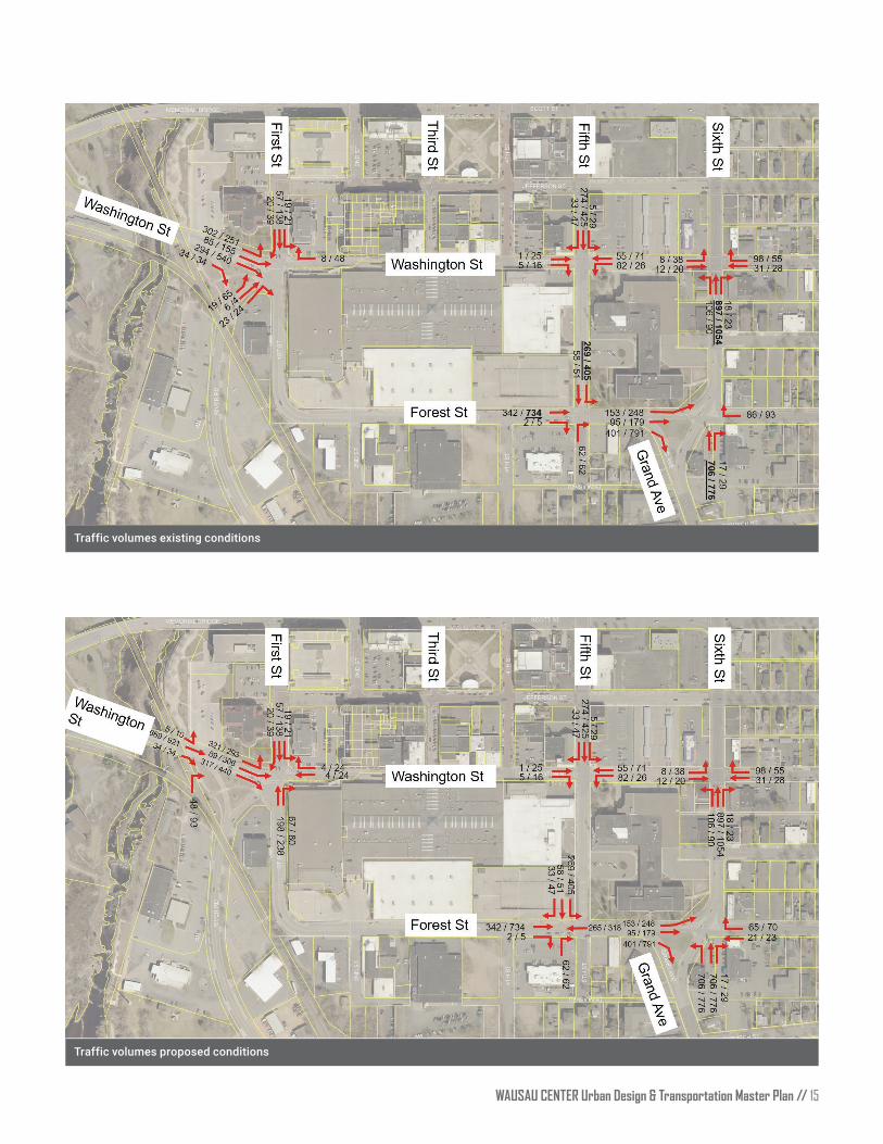
Traffic AnalysisExisting and Proposed conditions were modeled for the two critical intersections – 1st Street/River Drive/Washington Street and Grand Avenue/Forest Street/6th Street. The AM and PM peak hours were modeled for both intersections. Analysis was based on existing traffic volumes; a future year growth rate was not applied.
Refer to the existing and proposed traffic analysis diagrams on the next page
1st Street/River Drive/Washington StreetThe existing and proposed signalized conditions at this intersection were evaluated using Synchro 10.1. Under existing conditions, signal operations are actuated-uncoordinated. Cycle lengths are between 80 and 100 seconds Because of the complex intersection geometry, split phasing divides the green light of a traffic signal into separate phases: one for turning vehicles and another for through-traffic and pedestrians. The northbound River Drive and southbound 1st Street operations are split phase This can lead to long wait times for pedestrians and drivers on lower priority approaches. Eastbound Washington Street over the Slough bridge is the priority movement, with a very
heavy right turn volume onto southbound 1st Street Under existing conditions, eastbound queues during the PM peak hour are over 200 feet, or approximately 10-11 cars per lane
Under the proposed conditions, 1st Street will be converted to two-way south of Washington Street and create a northbound approach. In addition, Washington Street will be modified to allow eastbound through traffic. An initial test of these additional movements with the current geometry and phasing suggested that delays would increase significantly. Therefore, under the proposed conditions, River Drive will be removed from this intersection and a new signalized intersection created 300 feet west as shown in the proposed traffic volumes diagram
Operationally, this geometric change allows for simplified signal phasing Overall intersection delay at Washington Street/1st Street is virtually unchanged and eastbound queues on Washington Street are reduced to a maximum of 160 feet, or 8 cars per lane The addition of a closely spaced intersection is not always ideal, however the proposed intersection reconfiguration pairs well with the proposed street network modifications.
Grand Avenue/Forest Street/6th StreetThis intersection was evaluated using SIDRA Intersection 7. The existing free-flow conditions and proposed two-lane modern roundabout conditions were evaluated. Under existing conditions there are almost no delays and queues are very short. During the PM peak hour, eastbound through vehicles on Forest Street occasionally must wait for a gap in northbound traffic.
Under proposed conditions the eastbound approach is reduced from three lanes to two lanes. However, the proposed changes do not introduce conflicting traffic for the eastbound approach Therefore, the increase in delay for that approach is minimal
The northbound Grand Avenue approach goes from a free-flow condition in existing conditions, to a yield condition with circulating eastbound Forest Avenue traffic. However, the two-lane roundabout has sufficient capacity to accommodate both approaches Queues are less than 100 feet for all approaches and will operate at a Level of Service of C or better
WAUSAU CENTER Urban Design & Transportation Master Plan // 15
Traffic volumes existing conditions
Traffic volumes proposed conditions

// WAUSAU CENTER Urban Design & Transportation Master Plan 16
Street Modifications1st Street // Washington Street to Forest Street1st Street currently operates one-way southbound and consists of a two-lane street with five foot wide sidewalks adjacent to the curbs. The curb to curb width of the street is 40 feet and the street functions as a direct connection from the Slough Bridge into Wausau Center 1st Street routes around the Wausau Center transitioning to Forest Street and functions more as a bypass around downtown Wausau to the south. There are few street trees and it has city standard light fixtures on both sides that are located within the existing sidewalk.
The proposed modifications include moving the curb lines and converting from one-way to two-way roadway operations The additional space created by these modifications could be used to create wider pedestrian facilities with vegetation buffers on both sides. Street trees and light fixtures should be placed outside the sidewalk zone in a dedicated furnishing zone that will also help calm traffic by visually narrowing the roadway. Also, shifting both curb lines allows enough space for a two-way low stress bicycle facility on the west side of the street. The two-way bicycle facility should be a minimum of 8 feet in width and include a 2-foot buffer at sidewalk level.
1st Street // Washington Street to Forest Street // Short-termA short-term strategy could be applied to 1st Street from Washington Street to Forest Street by modifying existing pavement markings, signage, and signals to achieve a design similar to the preferred condition
The proposed short-term modifications should include converting from one-way to two-way roadway operations without adjusting the existing curb lines. Reallocating the curb to curb width with pavement markings would allow two-way vehicle travel and a buffered two-way bicycle facility on the south side with vertical separation, such as flexible delineators. Signal modifications would need to be considered at the intersection of 1st Street/River Drive/Washington Street to accommodate the new vehicle movements northbound on 1st Street Travel lane reassignments eastbound from the Slough Bridge should be modified to accommodate the northbound travel lane on 1st Street. The new travel lane configuration eastbound from the Slough Bridge would consist of
a right turn lane onto River Drive, a through lane onto 1st Street, with the remaining travel lanes unmodified. Consideration should also be given to closing the parking ramp driveway entrance on 1st Street. It is also recommended to terminate the two-way bicycle facility prior to the River Drive intersection providing users an opportunity to access the sidewalk pedestrian queueing area Consideration may also be given to implementing the bicycle facility without modifying current roadway operations or signal adjustments. This interim strategy would also align with the preferred cross section once implementation is approved
1st Street preferred conditions (looking south)
1st Street existing conditions (looking south)
1st Street short-term preferred conditions (looking south)
WAUSAU CENTER Urban Design & Transportation Master Plan // 17
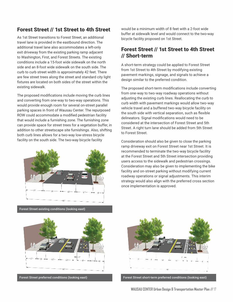
would be a minimum width of 8 feet with a 2-foot wide buffer at sidewalk level and would connect to the two-way bicycle facility proposed on 1st Street
Forest Street // 1st Street to 4th Street // Short-termA short-term strategy could be applied to Forest Street from 1st Street to 4th Street by modifying existing pavement markings, signage, and signals to achieve a design similar to the preferred condition
The proposed short-term modifications include converting from one-way to two-way roadway operations without adjusting the existing curb lines. Reallocating the curb to curb width with pavement markings would allow two-way vehicle travel and a buffered two-way bicycle facility on the south side with vertical separation, such as flexible delineators. Signal modifications would need to be considered at the intersection of Forest Street and 5th Street A right turn lane should be added from 5th Street to Forest Street.
Consideration should also be given to close the parking ramp driveway exit on Forest Street near 1st Street. It is recommended to terminate the two-way bicycle facility at the Forest Street and 5th Street intersection providing users access to the sidewalk and pedestrian crossings. Consideration may also be given to implementing the bike facility and on-street parking without modifying current roadway operations or signal adjustments. This interim strategy would also align with the preferred cross section once implementation is approved
Forest Street existing conditions (looking east)
Forest Street preferred conditions (looking east)
Forest Street // 1st Street to 4th StreetAs 1st Street transitions to Forest Street, an additional travel lane is provided in the eastbound direction The additional travel lane also accommodates a left-only exit driveway from the existing parking ramp adjacent to Washington, First, and Forest Streets. The existing conditions include a 15-foot wide sidewalk on the north side and an 8-foot wide sidewalk on the south side. The curb to curb street width is approximately 42 feet. There are few street trees along the street and standard city light fixtures are located on both sides of the street within the existing sidewalk.
The proposed modifications include moving the curb lines and converting from one-way to two-way operations. This would provide enough room for several on-street parallel parking spaces in front of Wausau Center The repurposed ROW could accommodate a modified pedestrian facility that would include a furnishing zone. The furnishing zone can provide space for street trees for a vegetation buffer, in addition to other streetscape site furnishings Also, shifting both curb lines allows for a two-way low-stress bicycle facility on the south side. The two-way bicycle facility
Forest Street short-term preferred conditions (looking east)
// WAUSAU CENTER Urban Design & Transportation Master Plan 18
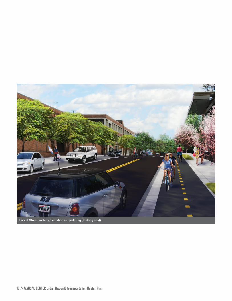
Forest Street preferred conditions rendering (looking east)

WAUSAU CENTER Urban Design & Transportation Master Plan // 19
Washington StreetWashington Street alternates between one-way and two-way operations with varying curb to curb and ROW widths within the project study area. Most of Washington Street within the study area is one-way, although it changes directions at Third Street Washington Street is one-way eastbound from 1st Street to 3rd Street, and one-way westbound from 3rd Street to 6th Street. Since, Washington Street has seen recent streetscape investments, the proposed strategy for Washington Street is an interim solution, which could be implemented with the proposed modified street network, and a preferred concept that would require additional ROW as a long-term solution. The recommended interim modifications to Washington Street are low-cost and easy to implement. The longer-term preferred concept design would require significant planning and coordination between the City, local agencies, and property owners to maximize opportunities for a complete street and minimize adverse impacts.
Washington Street // 1st Street to 2nd Street and 4th Street to 6th Street (interim)Washington Street has two-way operations from 1st Street to approximately 2nd Street (350 feet east of the 1st Street intersection). The short stretch of two-way traffic is provided to accommodate parking for the Wausau Center parking ramp and to facilitate service vehicles accessing the loading dock at Wausau Center Washington Street from 4th Street to 6th Street also consists of two-way traffic operations. The two-way segments of Washington Street generally consist of a curb to curb street width of 34 feet with a travel lane in each direction and on-street parallel parking on the south side The existing conditions include an 8-foot wide sidewalk on the north side and south side. There are few street trees along the street and standard city light fixtures are located on both sides of the street generally outside the sidewalk zone.
The proposed modifications include an interim phase maintaining the existing curb to curb width of 34 feet. During the interim phase, shared lane markings should be added to the existing travel lanes The addition of shared lane markings assist with the lateral positioning of a bicyclist, alert road users that bicyclists may occupy this space, and reduce the incidence of wrong-way bicycling. The existing furnishing zone and amenities would be maintained
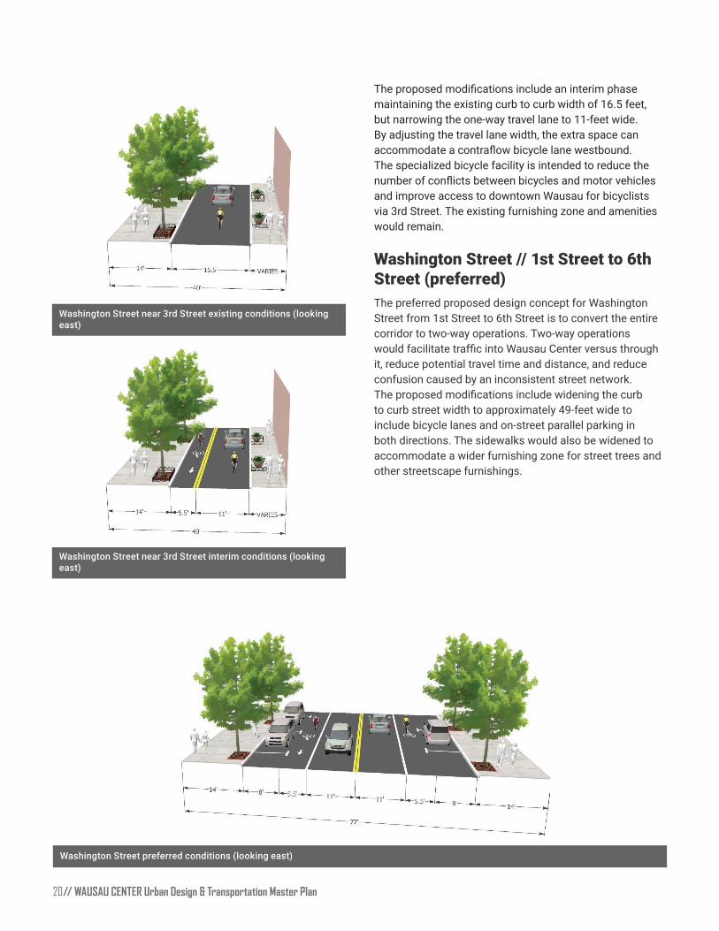
Washington Street // Near 3rd StreetWashington Street has one-way operations from 2nd Street (approximately 300 feet west of 3rd Street) to 4th Street. The intersection of 3rd Street and Washington Street is stop controlled for both eastbound and westbound movements and includes a raised concrete island to prevent straight-through movements. 3rd Street is one-way northbound with alternating angled parking. The one-way segments of Washington Street generally consist of a curb to curb street width of 16.5 feet. The existing sidewalk facility on the north side includes a 14-foot wide space with raised landscape planters and streetscape furnishings. The existing sidewalk facility on the south side generally provides a width of 8 feet with additional covered pedestrian space provided under the Wausau Center awnings. There is a short section of space allocated for emergency vehicles on the south side of Washington Street east of 3rd Street
Washington Street existing conditions (looking east)
Washington Street interim conditions (looking east)
// WAUSAU CENTER Urban Design & Transportation Master Plan 20
Washington Street near 3rd Street interim conditions (looking east)
Washington Street preferred conditions (looking east)
The proposed modifications include an interim phase maintaining the existing curb to curb width of 16.5 feet, but narrowing the one-way travel lane to 11-feet wide. By adjusting the travel lane width, the extra space can accommodate a contraflow bicycle lane westbound. The specialized bicycle facility is intended to reduce the number of conflicts between bicycles and motor vehicles and improve access to downtown Wausau for bicyclists via 3rd Street. The existing furnishing zone and amenities would remain.
Washington Street // 1st Street to 6th Street (preferred)The preferred proposed design concept for Washington Street from 1st Street to 6th Street is to convert the entire corridor to two-way operations. Two-way operations would facilitate traffic into Wausau Center versus through it, reduce potential travel time and distance, and reduce confusion caused by an inconsistent street network. The proposed modifications include widening the curb to curb street width to approximately 49-feet wide to include bicycle lanes and on-street parallel parking in both directions. The sidewalks would also be widened to accommodate a wider furnishing zone for street trees and other streetscape furnishings
Washington Street near 3rd Street existing conditions (looking east)
WAUSAU CENTER Urban Design & Transportation Master Plan // 21
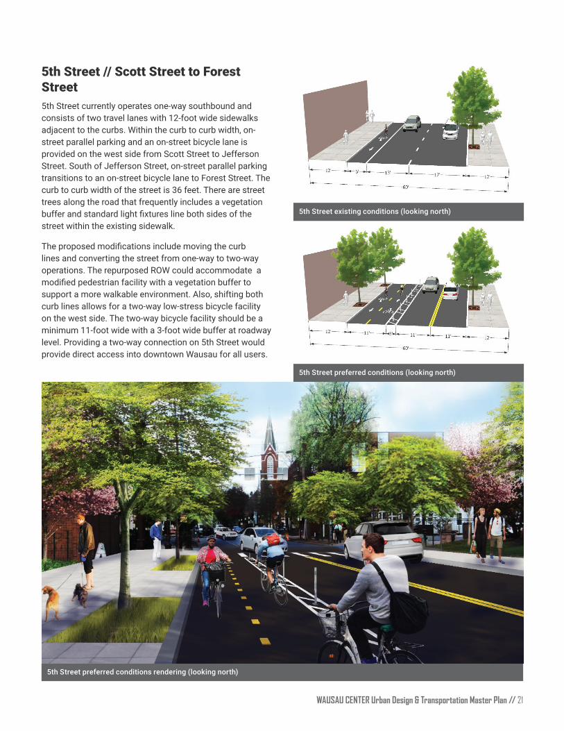
5th Street // Scott Street to Forest Street5th Street currently operates one-way southbound and consists of two travel lanes with 12-foot wide sidewalks adjacent to the curbs. Within the curb to curb width, on-street parallel parking and an on-street bicycle lane is provided on the west side from Scott Street to Jefferson Street. South of Jefferson Street, on-street parallel parking transitions to an on-street bicycle lane to Forest Street. The curb to curb width of the street is 36 feet. There are street trees along the road that frequently includes a vegetation buffer and standard light fixtures line both sides of the street within the existing sidewalk.
The proposed modifications include moving the curb lines and converting the street from one-way to two-way operations The repurposed ROW could accommodate a modified pedestrian facility with a vegetation buffer to support a more walkable environment. Also, shifting both curb lines allows for a two-way low-stress bicycle facility on the west side. The two-way bicycle facility should be a minimum 11-foot wide with a 3-foot wide buffer at roadway level. Providing a two-way connection on 5th Street would provide direct access into downtown Wausau for all users.
5th Street preferred conditions (looking north)
5th Street preferred conditions rendering (looking north)
5th Street existing conditions (looking north)

// WAUSAU CENTER Urban Design & Transportation Master Plan 22
Because of the complex intersection geometry, northbound River Drive and southbound 1st Street operations are currently split phase. This can lead to long wait times for pedestrians and drivers on lower priority approaches. Eastbound Washington Street over the Slough Bridge is the priority movement, with a very heavy right turn volume onto southbound 1st Street. The unique geometry and challenging pedestrian crossings make it difficult to navigate the intersection
Under the proposed conditions, 1st Street will be converted to two-way south of Washington Street, which will create a northbound approach. In addition, Washington Street will be modified to allow eastbound through traffic. Modifying the intersection to accommodate the movements detailed will have several benefits, including:
• Creating a signalized, non-motorized crossing for the Rivers Edge trail crossing Washington Street;
• Providing westbound motor vehicle access to the Marathon County Library parking lot;
• Simplifying operations at the Washington Street / 1st Street intersection;
• Reduce cycle lengths, which will reduce delays for pedestrians and drivers;
• Reducing queue lengths;
Entry Sequence Modifications1st Street/River Drive/Washington StreetThis section of the report recommends a series of modifications for the primary entry points to downtown Wausau to create a sense of arrival and to increase the safety and comfort of all roadway users at these critical gateways.
Entering downtown Wausau from the west primarily occurs from the Slough Bridge The streets have differing contexts and ROW widths vary as you enter downtown Wausau. The varying land use and ROW width result in a lack of a sense of arrival. The proposed street modifications are intended to be attractive and inviting for all users and should also set an expectation of how motor vehicles should behave while navigating among other modes of transportation. As previously mentioned, the Complete Streets design concept encourages promoting the comfort of vulnerable users. Enhancing this gateway will help convey the shift in context, increased presence of pedestrians and bicyclists, and changes in expectations for drivers
Entry sequence modifications for 1st Street/River Drive/Washington Street
WAUSAU CENTER Urban Design & Transportation Master Plan // 23
• Improving the visibility of the River Drive entrance; and
• Creating space for an improved gateway entrance into downtown Wausau.
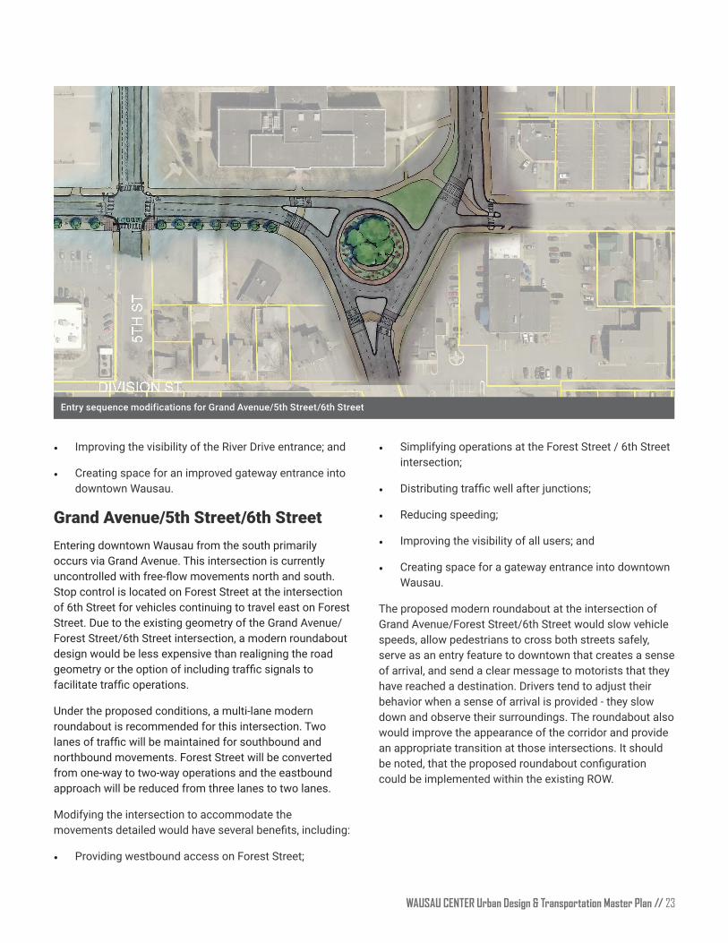
Grand Avenue/5th Street/6th StreetEntering downtown Wausau from the south primarily occurs via Grand Avenue This intersection is currently uncontrolled with free-flow movements north and south. Stop control is located on Forest Street at the intersection of 6th Street for vehicles continuing to travel east on Forest Street Due to the existing geometry of the Grand Avenue/Forest Street/6th Street intersection, a modern roundabout design would be less expensive than realigning the road geometry or the option of including traffic signals to facilitate traffic operations.
Under the proposed conditions, a multi-lane modern roundabout is recommended for this intersection. Two lanes of traffic will be maintained for southbound and northbound movements. Forest Street will be converted from one-way to two-way operations and the eastbound approach will be reduced from three lanes to two lanes.
Modifying the intersection to accommodate the movements detailed would have several benefits, including:
• Providing westbound access on Forest Street;
• Simplifying operations at the Forest Street / 6th Street intersection;
• Distributing traffic well after junctions;
• Reducing speeding;
• Improving the visibility of all users; and
• Creating space for a gateway entrance into downtown Wausau
The proposed modern roundabout at the intersection of Grand Avenue/Forest Street/6th Street would slow vehicle speeds, allow pedestrians to cross both streets safely, serve as an entry feature to downtown that creates a sense of arrival, and send a clear message to motorists that they have reached a destination. Drivers tend to adjust their behavior when a sense of arrival is provided - they slow down and observe their surroundings. The roundabout also would improve the appearance of the corridor and provide an appropriate transition at those intersections. It should be noted, that the proposed roundabout configuration could be implemented within the existing ROW.
Entry sequence modifications for Grand Avenue/5th Street/6th Street

// WAUSAU CENTER Urban Design & Transportation Master Plan 24
MaintenanceThis section provides guidance on year-round maintenance for bicycle and pedestrian facilities, including sidewalks, crosswalks, curb ramps, shared use paths, and bicycle lanes Maintaining bicycle and pedestrian facilities year-round is critical to ensuring those facilities are accessible, safe, and functional This section is divided into two sub-sections:
• All-season maintenance; and
• Winter maintenance
All-season maintenance covers topics such as general maintenance, pavement preservation and repair, and pavement markings, bicycle racks, and signage Winter maintenance outlines best practices for maintaining bicycle and pedestrian facilities in the winter, including snow and ice removal, pre- and post-winter storm treatments, and winter maintenance programs.
All-Season Maintenance General Maintenance
General maintenance includes on-going upkeep such as sweeping, vegetation management, and signage and bike rack repair. Sweeping of bicycle and pedestrian facilities should be done on a semi-regular basis, at least once in the spring and once in the fall, to clear bikeways and walkways of sand, leaves, or other debris. Special sweeping equipment can be purchased, such as broom attachments that attach to utility vehicles
Vegetation management includes the maintenance of grass, trees, shrubs, bushes, and other organic material Vegetation management is typically performed on an ongoing, as-needed basis. Lastly, signs along bike and pedestrian facilities also require maintenance, as they can become accidentally damaged, vandalized, or worn through natural aging. To mitigate graffiti vandalism, signs can be treated with an anti-graffiti coating that makes it easier to remove common forms of graffiti such as spray paint and marker pens Signs that are replaced due to aging or accidental damage should be replaced on an as-needed basis, which varies based on sign type and level of damage
Bicycle racks may be damaged over time or from maintenance equipment bumping into them, including snow plows. Depending on the severity of the damage, damaged bicycle racks may be able to be repaired
relatively easily Racks that are seriously damaged may require removal and replacement with a new rack.
Winter MaintenanceSnow and Ice Clearing
Clearing or removing snow and ice from bicycle and pedestrian facilities promotes year-round use of those facilities and reduces hazardous conditions. Snow clearance from on-street bikeways is typically performed at the same time as snow clearance from drive lanes. However, maintaining a high level of service for clearing on-street bike lanes can be challenging due to bike lanes often placed adjacent to parked cars. When bike lanes are adjacent to parked cars it is very difficult for snow plows to plow the bike lanes without causing damage to parked cars Another problem is there is no place to store the snow besides plowing it next to the cars, creating challenges for the parked cars to pull back into the street Moreover, cars pulling out of the parallel parking spots on the street or cars driving parallel to the bike lanes often drag or splash snow and ice into the bike lane, adding to the difficulty of providing cleared bike lanes.
Winter maintenance of off-street bikeways or shared-use paths should be prioritized to promote year-round use. Some communities have developed winter maintenance priority networks, which give bicyclists clear expectations of when they can expect bikeways to be clear of snow and ice. The City of Madison has a priority network of off-street trails, which includes paths that are primary bicycle commuter routes. This trail network is a top priority for snow and ice control in the winter, with the goal of having all priority trails cleared by 7 AM on weekdays to facilitate bicyclists commuting to work or school.
There are two general types of sidewalk snow and ice clearing practices found across North America:
1. Property owners are required to clear all snow and ice from sidewalks adjacent to their properties, as well as spread sand or salt to mitigate slippery surfaces.
2. City-led sidewalk snow and ice clearance, which utilizes either City staff or hired contractors to clear snow and ice from all sidewalks in the jurisdiction. These policies usually go into effect only after a snowfall depth reaches a certain threshold
The most common practice is to require adjacent property owners to clear all snow and ice from sidewalks that abut their property in a given period of time, which generally varies from 4-24 hours after a snowfall has stopped. Cities
WAUSAU CENTER Urban Design & Transportation Master Plan // 25
that require adjacent property owners to clear sidewalks normally enforce these laws by issuing warnings for non-compliance, followed by citations given after a period of time to property owners who do not comply. Cities often have inspectors that examine sidewalk snow clearing on a regular basis, and inspections are also driven by receiving complaints from the public The level of enforcement varies significantly from city to city; some cities very rarely issue citations, while other cities issue citations for non-compliance the day after a snow event.
City-led sidewalk snow and ice clearance practices are less common, primarily due to the perceived cost of implementation (labor and equipment), the number of sidewalks within a city’s boundary, and the perception that city-led efforts are less timely than property-owner led efforts. However, city-led sidewalk clearing practices can be very effective in clearing snow from sidewalks in a timely, consistent, and quality manner. These practices are beneficial to those who cannot physically clear sidewalks abutting their properties, and also cover winter sidewalk maintenance adjacent to abandoned properties which is sometimes the responsibility of the city. It is also particularly important in high-demand locations such at downtown Wausau and transit-center access routes. City-led sidewalk clearing practices generally require property owners to pay for the service through property taxes or additional fees
Intersection corners are a particularly challenging issue for pedestrian in the winter because of the snow windrows
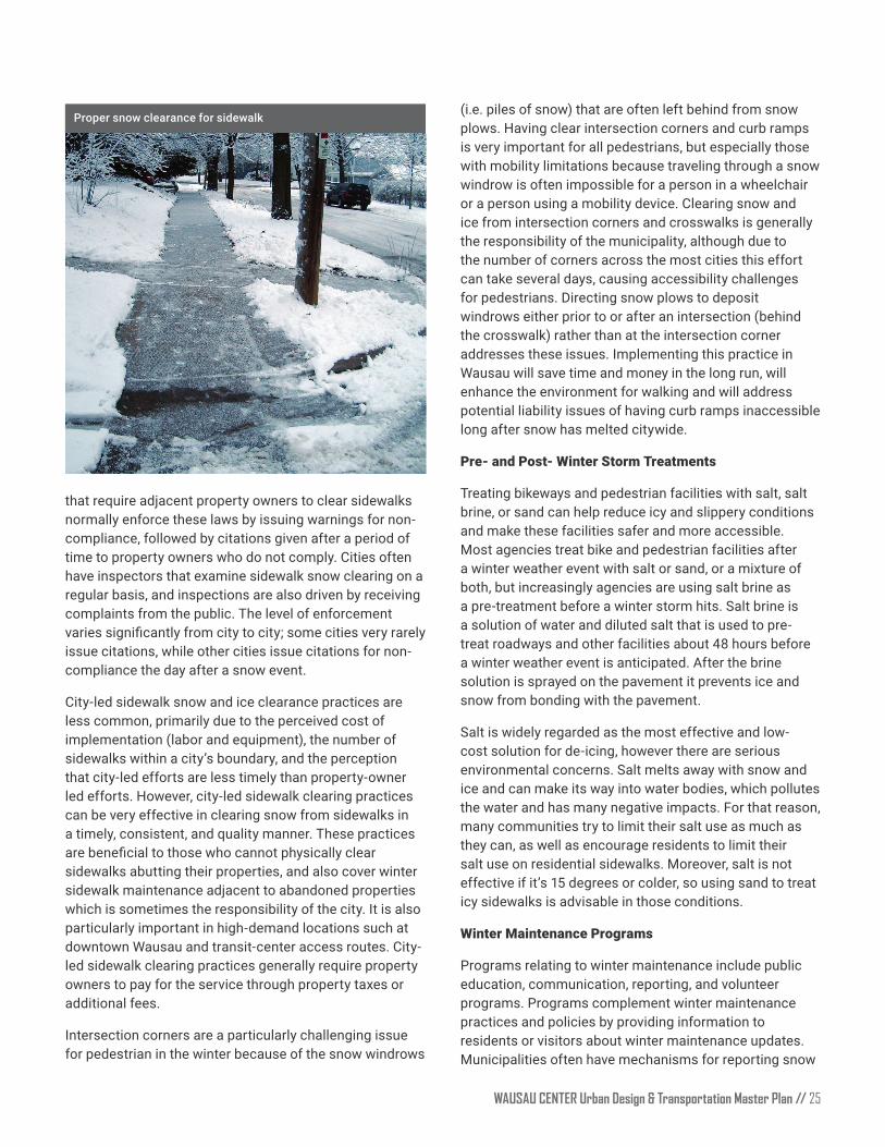
(i.e. piles of snow) that are often left behind from snow plows. Having clear intersection corners and curb ramps is very important for all pedestrians, but especially those with mobility limitations because traveling through a snow windrow is often impossible for a person in a wheelchair or a person using a mobility device. Clearing snow and ice from intersection corners and crosswalks is generally the responsibility of the municipality, although due to the number of corners across the most cities this effort can take several days, causing accessibility challenges for pedestrians. Directing snow plows to deposit windrows either prior to or after an intersection (behind the crosswalk) rather than at the intersection corner addresses these issues. Implementing this practice in Wausau will save time and money in the long run, will enhance the environment for walking and will address potential liability issues of having curb ramps inaccessible long after snow has melted citywide.
Pre- and Post- Winter Storm Treatments
Treating bikeways and pedestrian facilities with salt, salt brine, or sand can help reduce icy and slippery conditions and make these facilities safer and more accessible Most agencies treat bike and pedestrian facilities after a winter weather event with salt or sand, or a mixture of both, but increasingly agencies are using salt brine as a pre-treatment before a winter storm hits. Salt brine is a solution of water and diluted salt that is used to pre-treat roadways and other facilities about 48 hours before a winter weather event is anticipated. After the brine solution is sprayed on the pavement it prevents ice and snow from bonding with the pavement.
Salt is widely regarded as the most effective and low-cost solution for de-icing, however there are serious environmental concerns. Salt melts away with snow and ice and can make its way into water bodies, which pollutes the water and has many negative impacts. For that reason, many communities try to limit their salt use as much as they can, as well as encourage residents to limit their salt use on residential sidewalks. Moreover, salt is not effective if it’s 15 degrees or colder, so using sand to treat icy sidewalks is advisable in those conditions.
Winter Maintenance Programs
Programs relating to winter maintenance include public education, communication, reporting, and volunteer programs. Programs complement winter maintenance practices and policies by providing information to residents or visitors about winter maintenance updates. Municipalities often have mechanisms for reporting snow
Proper snow clearance for sidewalk
// WAUSAU CENTER Urban Design & Transportation Master Plan 26
and ice issues, as well as tools for tracking the progress of maintenance crews. Some cities have programs that provide free sand or salt to residents, which encourages property owners to eliminate slippery, hazardous sidewalks by providing them an inexpensive way to maintain sidewalks in the winter.
Snow and ice clearing is challenging for the elderly or property owners who are physically disabled, so some communities organize and develop volunteer programs that aim to those in need with shoveling their sidewalks. These programs, sometimes called “snow angels” or “snow buddies”, mobilize volunteers who are physically able to shovel and scrape ice, which can help keep seniors safe from falls on snow or ice during the winter.
PrioritizationThe priority of the projects above will be largely dictated by the available funding sources and community desires Some of these projects have the potential to be jointly funded through partnerships between WisDOT, Marathon County, and the City of Wausau. In addition, WisDOT has ownership of several of the roads in the study area and therefore would be primarily responsible or closely involved with changes within their ROW.
Many of the street modifications recommended above could be tested as demonstration projects. A demonstration project can inexpensively, quickly, and temporarily explore modifications within the public ROW. This tactic allows immediate yet temporary changes and can help build support and understanding of a project. A demonstration project can often times be paired with another community event to get additional feedback and support
WisDOTThe street modifications proposed for 1st Street, Forest Street, and the intersection of Forest Street/Grand Avenue/6th Street all fall within WisDOT ROW and they would be responsible for the costs and phasing. The roundabout proposed for Forest Street/Grand Avenue/6th Street and the intersection modifications to 1st Street/Forest Street/Washington detailed in this plan will require additional time for design and implementation; however both changes are vital to the downtown Wausau street network, connectivity improvements, and potential redevelopment opportunities
Specifically, 1st Street, Forest Street and 6th Street are all
identified as existing State Trunk Highway 51 and Business Route 52. Grand Avenue is identified as Business Route 51. Additional coordination will be needed for these street segment modifications.
City of WausauExisting timing for capital improvement projects should continue as needed, but the City should focus its attention on the downtown elements of this plan.
1 Convert 5th Street from one-way to two-way: The conversion of 5th Street from one-way to two-way could be relatively easily achieved through pavement markings and signage. Minor traffic signal modifications would also need to occur at Forest Street, Washington Street, and Scott Street. 5th Street may also be an excellent candidate for a demonstration project with the proposed two-way bicycle facility
2 Convert Washington Street to one-way eastbound: The street modifications to Washington Street should be next on the improvement master plan As previously detailed, the interim strategy converting Washington Street to one-way eastbound should be implemented first.
3 Entry sequence intersection modifications: While these street modifications are underway, the City can coordinate with WisDOT for the design and planning for the entry sequence modifications for 1st Street/Forest Street/Washington Street and Grand Avenue/Forest Street/6th Street intersections. The modifications to these intersections will focus on establishing a gateway and will also provide a catalyst for renewed attention to Wausau Center. The gateway modifications should also be coordinated with the design and planning of 1st Street and Forest Street corridors. The corridor modifications for 1st Street and Forest Street are critical for the entry sequence viability
4. Convert Washington Street to two-way: Lastly, the preferred two-way operations for Washington Street should be explored Wausau Center is poised for change and the modifications would facilitate the implementation of the preferred Washington Street corridor Since this design concept is a longer-term strategy, significant planning and coordination between the City, and property owners to maximize opportunities for a more complete street and minimize adverse impacts is recommended.
WAUSAU CENTER Urban Design & Transportation Master Plan // 27
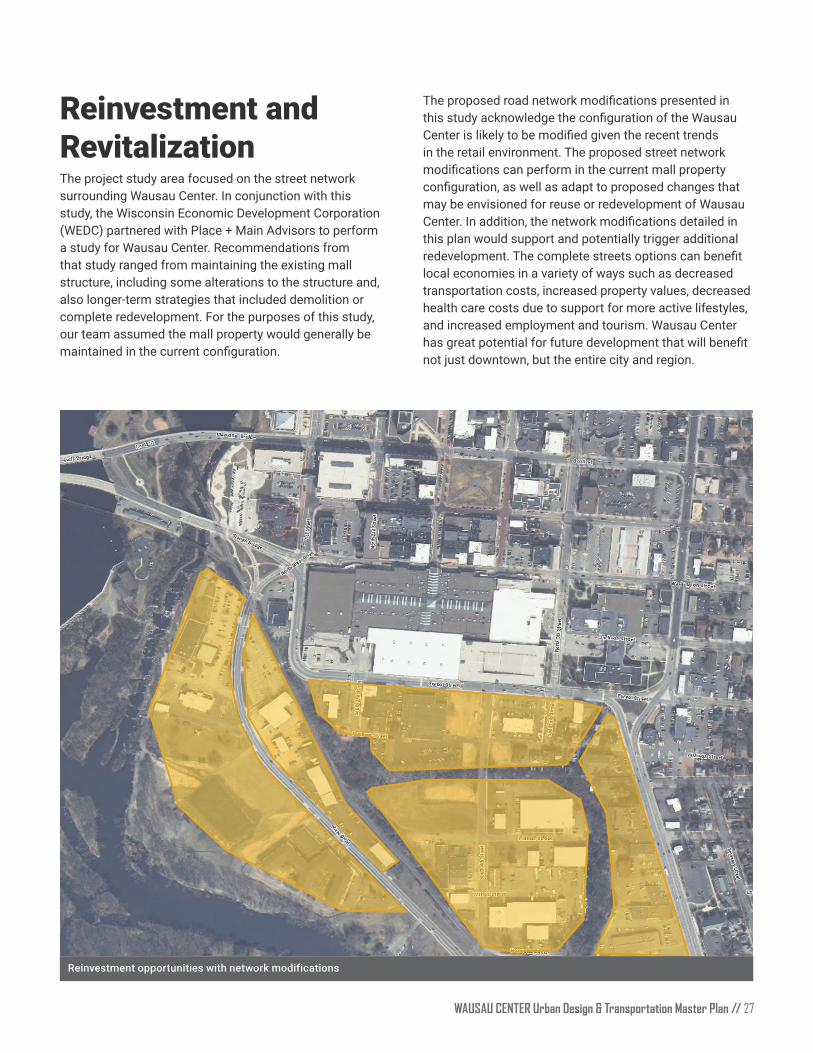
Reinvestment opportunities with network modifications
Reinvestment and RevitalizationThe project study area focused on the street network surrounding Wausau Center. In conjunction with this study, the Wisconsin Economic Development Corporation (WEDC) partnered with Place + Main Advisors to perform a study for Wausau Center Recommendations from that study ranged from maintaining the existing mall structure, including some alterations to the structure and, also longer-term strategies that included demolition or complete redevelopment. For the purposes of this study, our team assumed the mall property would generally be maintained in the current configuration.
The proposed road network modifications presented in this study acknowledge the configuration of the Wausau Center is likely to be modified given the recent trends in the retail environment. The proposed street network modifications can perform in the current mall property configuration, as well as adapt to proposed changes that may be envisioned for reuse or redevelopment of Wausau Center. In addition, the network modifications detailed in this plan would support and potentially trigger additional redevelopment. The complete streets options can benefit local economies in a variety of ways such as decreased transportation costs, increased property values, decreased health care costs due to support for more active lifestyles, and increased employment and tourism Wausau Center has great potential for future development that will benefit not just downtown, but the entire city and region.
// WAUSAU CENTER Urban Design & Transportation Master Plan 28
Cost EstimatesThe following construction cost estimates were developed by identifying major pay items and utilizing proposed roadway cross sections to determine a rough order of magnitude of cost. The cost estimates reflect a thirty percent contingency as they are conceptual design level opinion of probable cost. Please note that the estimates do not include costs for engineering analysis and design easement and right-of-way acquisition; permitting, inspection, or construction management; engineering, surveying, geotechnical investigation, environmental documentation, special site remediation, escalation, or the cost for ongoing maintenance Rough costs based on percentage have been assigned to general categories such as utility relocations and unforeseen risks These costs can vary widely depending on the exact details and nature of the work. The overall cost opinions are intended to be general and used only for planning purposes Toole Design Group, LLC makes no guarantees or warranties regarding the cost opinion herein Construction costs will vary based on the ultimate project scope, actual site conditions and constraints, schedule, and economic conditions at the time of construction
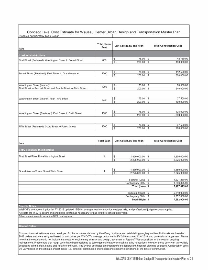
WAUSAU CENTER Urban Design & Transportation Master Plan // 29
Item
Total Linear Feet Unit Cost (Low and High) Total Construction Cost
Corridor Modifications75.00$ 48,750.00$
200.00$ 130,000.00$
75.00$ 112,500.00$ 200.00$ 300,000.00$
75.00$ 90,000.00$ 200.00$ 240,000.00$
75.00$ 37,500.00$ 200.00$ 100,000.00$
75.00$ 135,000.00$ 200.00$ 360,000.00$
75.00$ 97,500.00$ 200.00$ 260,000.00$
ItemTotal Each Unit Cost (Low and High) Total Construction Cost
Entry Sequence Modifications
1,850,000.00$ 1,850,000.00$ 2,225,000.00$ 2,225,000.00$
1,850,000.00$ 1,850,000.00$ 2,225,000.00$ 2,225,000.00$
Subtotal (Low) 4,221,250.00$ Contingency 30% 1,266,375.00$
5,487,625.00$
Subtotal (High) 5,840,000.00$ Contingency 30% 1,752,000.00$
7,592,000.00$
Concept Level Cost Estimate for Wausau Center Urban Design and Transportation Master PlanPrepared April 2019 by Toole Design
Total (Low)
1Grand Avenue/Forest Street/Sixth Street
Total (High)
Specific Notes:
All costs are in 2018 dollars and should be inflated as necessary for use in future construction years.All construction costs include a 30% contingency.
WisDOT's average unit price list FY 2018 updated 12/8/18, average road construction cost per mile, and professional judgement was applied.
Construction cost estimates were developed for the recommendations by identifying pay items and establishing rough quantities. Unit costs are based on 2018 dollars and were assigned based on unit prices per WisDOT’s average unit price list FY 2018 updated 12/6/2018, and professional judgement. Please note that the estimates do not include any costs for engineering analysis and design, easement or Right-of-Way acquisition, or the cost for ongoing maintenance. Please note that rough costs have been assigned to some general categories such as utility relocations, however these costs can vary widely depending on the exact details and nature of the work. The overall estimates are intended to be general and used for planning purposes. Construction costs will vary based on the ultimate project scope (i.e. potential combination of projects) and economic conditions at the time of construction.
First Street (Preferred): Washington Street to Forest Street 650
1500Forest Street (Preferred): First Street to Grand Avenue
Washington Street (Interim):First Street to Second Street and Fourth Street to Sixth Street 1200
500Washington Street (Interim) near Third Street
Washington Street (Preferred): First Street to Sixth Street 1800
Fifth Street (Preferred): Scott Street to Forest Street 1300
First Street/River Drive/Washington Street 1
General Notes:

THIS PAGE INTENTIONALLY LEFT BLANK
// WAUSAU CENTER Urban Design & Transportation Master Plan 30
WAUSAU CENTER Urban Design & Transportation Master Plan // 31
APPENDIX
Appendix A // Community Outreach Survey
THIS PAGE INTENTIONALLY LEFT BLANK
// WAUSAU CENTER Urban Design & Transportation Master Plan 32

City of Wausau
407 Grant Street
Wausau, WI 54406
http://www.ci.wausau.wi.us/