water scarcity management in southern kpk: lessons in ... · 1998). most parts of sindh and...
TRANSCRIPT
Water Scarcity Management in Southern KPK: Lessons in Capacity Building of Farmers for Securing Water for Dryland Ecosystem
Management
Sahibzada Irfanullah Khan
Sustainable Land Management Programme (SLMP-II)
Planning & Development Deptt., Planning & Development Department
Peshawar, Pakistan. Post Code 25000.
Cell: 0092-300-5822775
Ph: 0092-91-9223444
Email: [email protected]
ABSTRACT
Drylands in southern Pakistan are home to communities living in poverty and depending
on livestock rearing for their livelihood. The subsistence agriculture is losing its
importance under the effects of climate change i.e. uncertain rainfall and very low
productivity. Due to increasing population of livestock, the pressure on silvo-pastures is
increasing resulting in degradation of natural resources and loss of soil fertility, a fact that
adversely affects the livelihood of communities. The Farm Forestry Support Project
(FFSP) of the Intercooperation (IC) and Swiss Agency for Development & Cooperation
(SDC), initiated rehabilitation work in 2010 in extreme dry region of Karak using the
silvo-pastoral system with hillside ditches and sand dune stabilization techniques. The
objective was harvest, conserve and use rain water for recovering vegetation and increase
productivity of the area with minimum cost and hence support livelihoods. The activity
was carried out with participation of civil society organizations and farmers’ associations.
The results recorded in 2016 showed a profuse plant growth in terms of trees, shrubs and
grasses with a potential to provide timber, fuel wood and fodder for livestock. Maximum
harvesting of rainwater and conservation of moisture also resulted in growth of natural

grasses and shrubs. Within a short period of 5 years, plant growth in height and diameter
of 6 meters and 20 centimeters respectively was recorded. The average vegetation cover
of 45% and increase in soil organic mater and nitrogen content was also recorded. All this
happened with a minimum cost of US$ 82 per hectare. The rejuvenation of wells in few
cases was an additional positive affect of the activity. On the other hand, an annual
income of US$ 735 per hectare from Saccharum spontaneum planted in sand dunes was a
real benefit to farmers against the other land-uses in dry sand dunes.
Key words: Degraded rangelands, Semi-arid, Water Harvesting
1 INTRODUCTION
Drylands are generally defined as arid, semi-arid or dry sub-humid lands receiving less
than 500 mm annual rainfall with an aridity index between 0.05 and 0.65 (the aridity
index is the ratio Precipitation / Precipitation Evapotranspiration) (UNCCD/UNEP,
1999/7). There are more than 3 billion people globally living in drylands that cover 40%
of earth’s surface (ROBIN, 2002). Drylands are generally defined in climatic terms as
lands receiving less than 500 mm of annual rainfall. In Pakistan, the situation is severe
with 75% of the country’s area receiving less than 250 mm of annual rainfall (PMD
1998). Most parts of Sindh and Balochistan, and Southern parts of Punjab and NWFP are
falling within this dry zone; (GoP 2006).
Over 30 million people in Pakistan live in dryland areas. Their livelihoods depend
heavily on the natural resource base in form of provision of food for human beings,
fodder for livestock, fuel for cooking and heating, and water for drinking. Some scanty

income from the sale of medicinal plants and herbs, livestock and dairy products and
wildlife also add to the meager earnings (FISCHLER, 2006).
The poor in these ecologically fragile marginal lands are increasingly locked into patterns
of natural resource degradation (FATA, GoP 2007). There are many factors responsible
for degradation of natural resources, the climate change promotes the process by limiting
the water availability and increasing temperature. Due to the low production and
regeneration potential, drylands are not able to support an ever-increasing population of
human beings and livestock. Most of the silvo-pastoral ecosystems in drylands are
degraded due to overstocking beyond their carrying capacity, whereas rainfed croplands
are increasingly being abandoned due to prolonged drought periods. These adverse
factors are continuously undermining the livelihoods of poor pastoral and farming
families.
2 THE STUDY AREA
The study relates to joint activities of the Farm Forestry Support Project (SDC, IC), local
NGOs and rural community organizations in Karak, one of 22 districts in the Southern
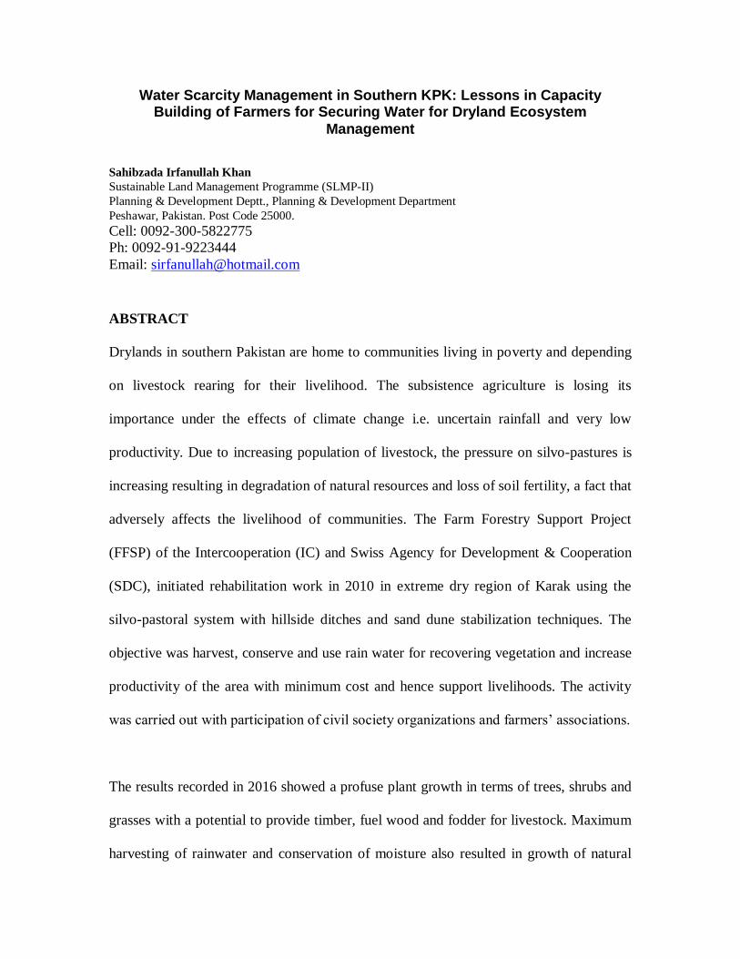
part of the Khyber-Pakhtunkhwa Province (NWFP) of Pakistan (Figure 1). District Karak
is situated in southern region of NWFP (Figure 1), covering an area of 3372 square
kilometers; (GoP, 1996). Total population of Karak is 430,000 heads; (GoP, 1998).
The area comes under tropical and sub-tropical climatic zone, characterized by arid and
semi-arid conditions. It can be divided into three distinct geographical divisions: the dry
hilly zone in north, sandy desert in south-west and sandy-loam plains in the eastern part.
The northern hilly zone is famous for mining of various minerals like salt and gypsum.
The south-western desert is characterized by shifting sand dunes, very dry and hot winds,
and subsistence cultivation of gram, mustard, groundnut and wheat. The eastern region is
famous for a number of agricultural crops (millets, wheat, maize) and vegetables (chilies,
okra, egg-plant, tomato) mainly because of availability of some irrigation water. As a
whole, 19% area is under cultivation out of which water is available for 2% area only;
(GoP, 2000).
People in this area live on subsistence agriculture, livestock rearing and minor trade of
daily use commodities. Literacy rate is surprisingly high (above 50%) as compared to the
rate for Pakistan (44%); (GoP, 1998). Due to harsh living conditions and limited
Figure 1: Location map of Karak (Source Google Earth)
opportunities on land, people prefer to join civil and armed services that are mostly out of
the area. The remittances they send back to their families are thus an important source of
living.
3 THE DRYLAND ECOSYSTEMS
The interplay between human beings, land resources, climatic conditions, natural
vegetation and livestock constitute the ecosystem in most of the drylands in Pakistan. In
all these, the climatic factors and availability of water for productive practices are
limiting factors. Again, in most of the cases vast tracts of land are available but
production systems are limited to only a few patches because of climatic conditions that
limit the availability of water.
In the study area, mean maximum temperature can reach to 46°C in summer (May to
September). The mean minimum temperature in winter months (November to February)
goes down to 3° C. The extreme arid conditions prevailing in major part of Karak limit
agriculture to a profit-less rather under-paying activity. Subsistence agriculture is totally
dependant on rainfall that is sporadic, uncertain and does not exceed 350 millimeters per
annum; (GoKP, 1998). Livestock rearing (mainly goats and sheep) is thus adopted as
major source of livelihood that supports the family in terms of nutrition and income from
sale of animals, wool and milk (Figure 2).

These limitations lead towards a silvo-pastoral way of living where natural vegetation
plays deciding role in the sustenance of the system. Sporadic grasses, shrubs and stunted
trees are all what is required for grazing herds (Figure 2). The local tree vegetation in this
area include Acacia modesta, Prosopis cineraria, Capparis aphylla, Prosopis glandulosa,
Tamarix aphylla, Zizyphus mauritiana, Olea ferruginea and Tecoma undulate. Some of
the important shrub species include Zizyphus numularia, Vitex negandu, Saccharum
munja, Callygonum polygonoides, Callotropis procera, and Nannorrhops ritchiana.
Among grasses, Chrysopogon spp., Cenchrus spp., and Cynodon dactylon are important.
Whereas Salsola foetida, Withania spp., and Erva javanica are common herbs. The
natural forest is limited to only 2% of the total area on distant hills; (GoP, 1998),
comprising mainly Acacia modesta and Olea ferruginea.
Availability of water for drinking purpose is also not certain. The water table is as low as
500 feet and it costs high to drill and pump the water out. There were some natural
springs in the hills that were providing drinking water to communities but dried out in
recent droughts (1992, 1998, 2002).
Figure 2: The drylands in Karak, Pakistan

4 STATEMENT OF THE PROBLEM
Most of the people in Karak live below poverty line. Their livelihood is dependant on
rainfed subsistence agriculture and livestock. The livestock is then dependant on natural
range vegetation in the form of low trees, shrubs and grasses. However, due to increasing
drought conditions and scarcity of rainfall, the agriculture is not more a productive
activity and croplands are increasingly abandoned. To fill this gap in livelihood, the
number of livestock per household is increasing with time. This exerts great pressure on
natural vegetation of the rangeland area that gets grazed more intensively and more
frequently. This leads to the degradation of ecosystem and depletion of natural
vegetation. The scanty rainfall condition, hot weather and sustained grazing pressure
restricts recovery potential of natural vegetation. The phenomenon thus adds to
desertification that compounds the problem of poverty and makes communities utterly
vulnerable to the situation.
The net effect of the problems stated above is observed in the form of increase in poverty
and vulnerability of the poor. The droughts leave negative effects on their capacity to
survive. In the efforts to survive, they become heavily indebted, their health is badly
affected and most of them migrate to urban areas.
5 METHODOLOGY
Keeping in view the importance of natural vegetation and the support it does provide to
local livelihoods, the Farm Forestry Support Project (FFSP) funded by Swiss Agency for
Development and Cooperation (SDC) and executed by the Intercooperation-Pakistan,
started the dryland management and rehabilitation program in District Karak. The
purpose was to rejuvenate the productive capacity of degraded lands so that the support
these lands were providing to livelihoods previously could be restored; (B.H. Shah 2011)
Based on the detailed area surveys and consultation sessions conducted in the region by
experts from FFSP through the local NGOs and farmers’ communities, rehabilitation
measures were designed to address the problem. In order to regain the depleted
vegetation cover and thereby restore the soil fertility for increased production in
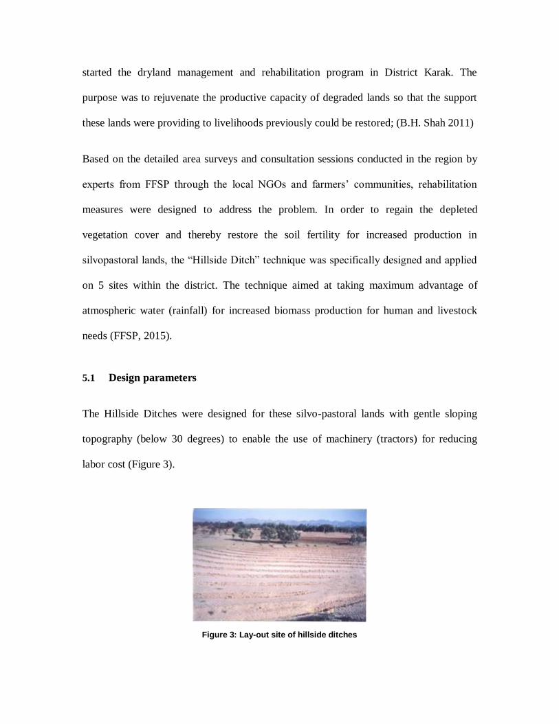
silvopastoral lands, the “Hillside Ditch” technique was specifically designed and applied
on 5 sites within the district. The technique aimed at taking maximum advantage of
atmospheric water (rainfall) for increased biomass production for human and livestock
needs (FFSP, 2015).
5.1 Design parameters
The Hillside Ditches were designed for these silvo-pastoral lands with gentle sloping
topography (below 30 degrees) to enable the use of machinery (tractors) for reducing
labor cost (Figure 3).
Figure 3: Lay-out site of hillside ditches
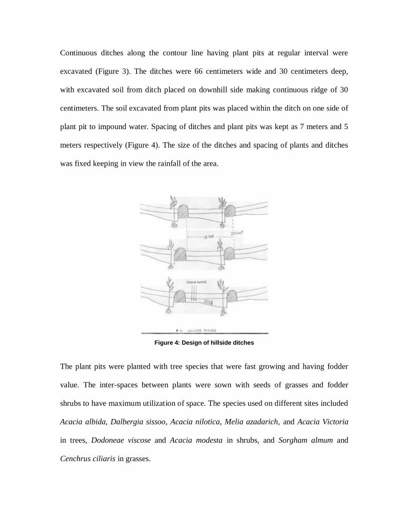
Continuous ditches along the contour line having plant pits at regular interval were
excavated (Figure 3). The ditches were 66 centimeters wide and 30 centimeters deep,
with excavated soil from ditch placed on downhill side making continuous ridge of 30
centimeters. The soil excavated from plant pits was placed within the ditch on one side of
plant pit to impound water. Spacing of ditches and plant pits was kept as 7 meters and 5
meters respectively (Figure 4). The size of the ditches and spacing of plants and ditches
was fixed keeping in view the rainfall of the area.
The plant pits were planted with tree species that were fast growing and having fodder
value. The inter-spaces between plants were sown with seeds of grasses and fodder
shrubs to have maximum utilization of space. The species used on different sites included
Acacia albida, Dalbergia sissoo, Acacia nilotica, Melia azadarich, and Acacia Victoria
in trees, Dodoneae viscose and Acacia modesta in shrubs, and Sorgham almum and
Cenchrus ciliaris in grasses.
Figure 4: Design of hillside ditches
On sites with sand dunes that kept shifting with winds, a sand dune stabilization
technique with a local species called “Khana” (Saccharum spontaneum) was applied.
Kana suckers were obtained from an adjacent district at the cost of Rs. 7 per sucker and
planted at a spacing of 5 meter x 3 meter in straight lines (Figure 10).
5.2 Instruments
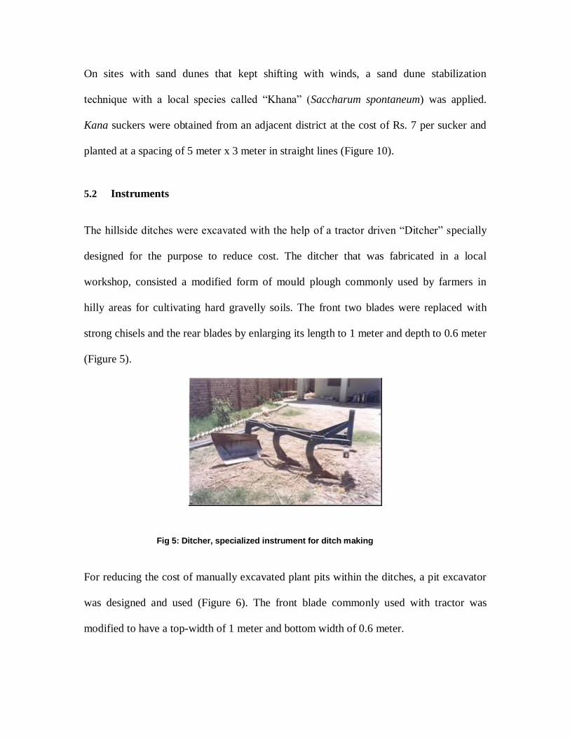
The hillside ditches were excavated with the help of a tractor driven “Ditcher” specially
designed for the purpose to reduce cost. The ditcher that was fabricated in a local
workshop, consisted a modified form of mould plough commonly used by farmers in
hilly areas for cultivating hard gravelly soils. The front two blades were replaced with
strong chisels and the rear blades by enlarging its length to 1 meter and depth to 0.6 meter
(Figure 5).
For reducing the cost of manually excavated plant pits within the ditches, a pit excavator
was designed and used (Figure 6). The front blade commonly used with tractor was
modified to have a top-width of 1 meter and bottom width of 0.6 meter.
Fig 5: Ditcher, specialized instrument for ditch making
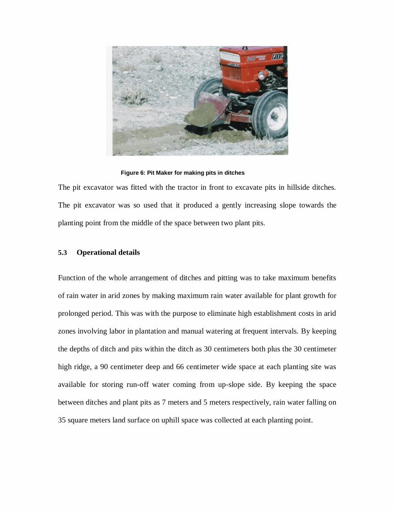
The pit excavator was fitted with the tractor in front to excavate pits in hillside ditches.
The pit excavator was so used that it produced a gently increasing slope towards the
planting point from the middle of the space between two plant pits.
5.3 Operational details
Function of the whole arrangement of ditches and pitting was to take maximum benefits
of rain water in arid zones by making maximum rain water available for plant growth for
prolonged period. This was with the purpose to eliminate high establishment costs in arid
zones involving labor in plantation and manual watering at frequent intervals. By keeping
the depths of ditch and pits within the ditch as 30 centimeters both plus the 30 centimeter
high ridge, a 90 centimeter deep and 66 centimeter wide space at each planting site was
available for storing run-off water coming from up-slope side. By keeping the space
between ditches and plant pits as 7 meters and 5 meters respectively, rain water falling on
35 square meters land surface on uphill space was collected at each planting point.
Figure 6: Pit Maker for making pits in ditches
6 RESULTS
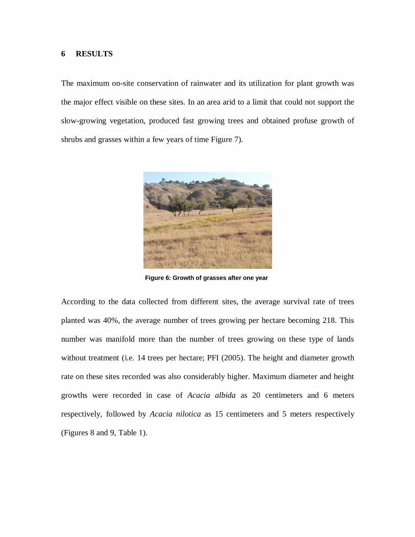
The maximum on-site conservation of rainwater and its utilization for plant growth was
the major effect visible on these sites. In an area arid to a limit that could not support the
slow-growing vegetation, produced fast growing trees and obtained profuse growth of
shrubs and grasses within a few years of time Figure 7).
According to the data collected from different sites, the average survival rate of trees
planted was 40%, the average number of trees growing per hectare becoming 218. This
number was manifold more than the number of trees growing on these type of lands
without treatment (i.e. 14 trees per hectare; PFI (2005). The height and diameter growth
rate on these sites recorded was also considerably higher. Maximum diameter and height
growths were recorded in case of Acacia albida as 20 centimeters and 6 meters
respectively, followed by Acacia nilotica as 15 centimeters and 5 meters respectively
(Figures 8 and 9, Table 1).
Figure 6: Growth of grasses after one year

Table 1: Growth data for trees, shrubs and grasses in Hillside Ditches: SAHIBZADA
(2015)
S.
No.
Parameter Species Data recorded
1 Average diameter Acacia albida 20 centimeters
Acacia nilotica 15 centimeters
2 Average height Acacia albida 6 meters
Acacia nilotica 5 meters
3 Av. no. of trees surviving / hectare Overall 218 numbers
4 Average vegetation soil cover Overall 45 %
Due to retention of run-off and percolation of run-off water into soil on the site, a profuse
growth of local annual and perennial grasses was recorded, in addition to the Sorgham
almum and Cenchrus ciliaris that was sown during plantation activity. The average soil
cover on these soils recorded was 45%, considerably high over normal cover on these
degraded lands (10-15% on the average). These grasses and shrubs were of high value as
a feed for local goats and sheep. The farmers were advised not to allow animals for
grazing in initial 2 years. They could, however cut grasses and stall-feed their animals
during these 2 years.
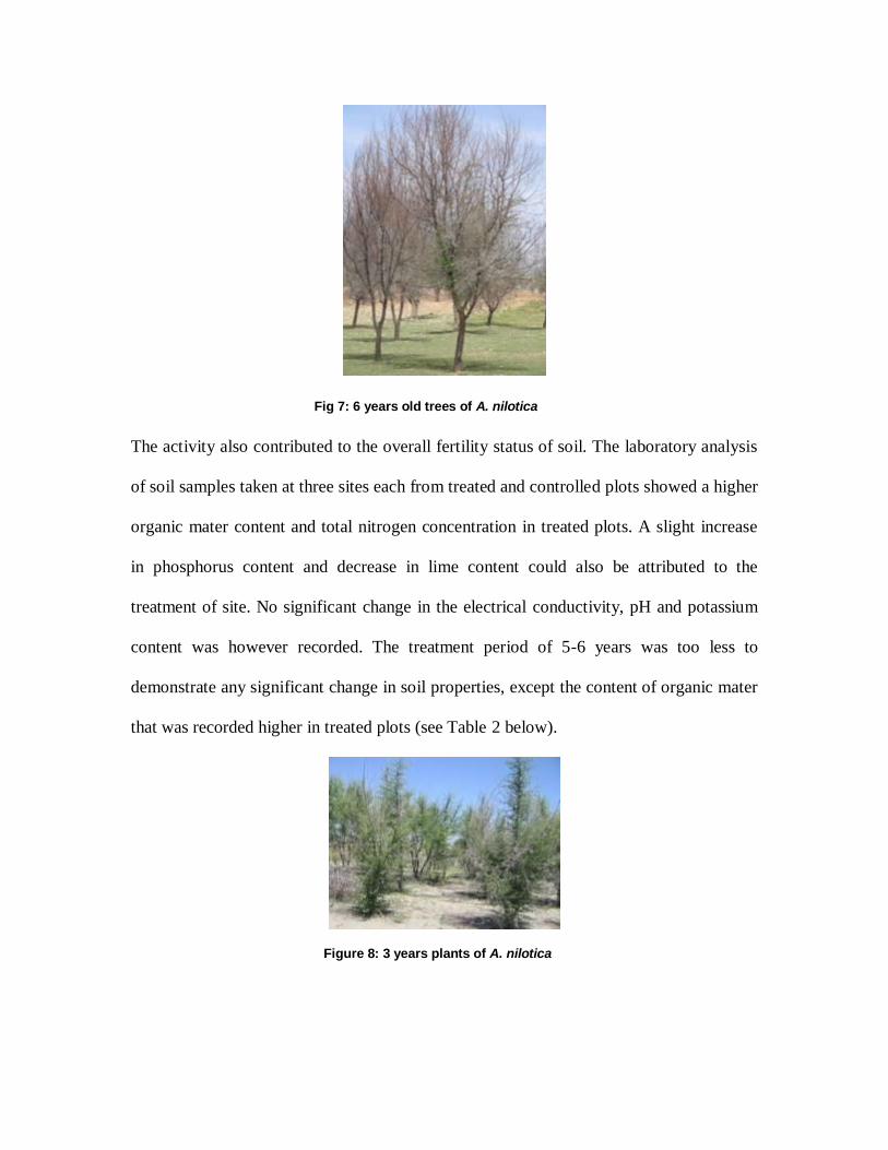
The activity also contributed to the overall fertility status of soil. The laboratory analysis
of soil samples taken at three sites each from treated and controlled plots showed a higher
organic mater content and total nitrogen concentration in treated plots. A slight increase
in phosphorus content and decrease in lime content could also be attributed to the
treatment of site. No significant change in the electrical conductivity, pH and potassium
content was however recorded. The treatment period of 5-6 years was too less to
demonstrate any significant change in soil properties, except the content of organic mater
that was recorded higher in treated plots (see Table 2 below).
Fig 7: 6 years old trees of A. nilotica
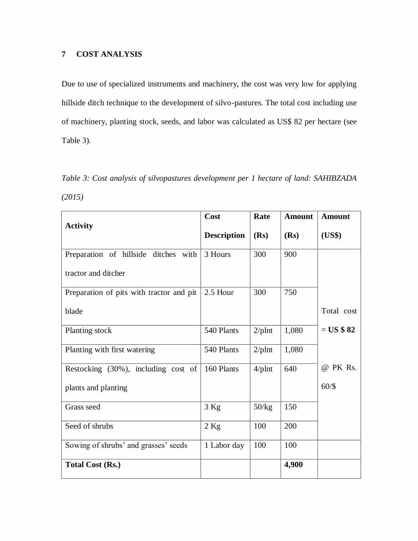
Figure 8: 3 years plants of A. nilotica

In addition to increase in on-site productivity and soil fertility, the activity also
contributed to the re-charge of ground water in down the slope areas. According to
information provided by local community, 2 wells that dried out due to prolonged
drought were rejuvenated near to the activity sites.
Table 2: Soil properties in treated and controlled plots:
S.No. Parameters Control plot Treated plot
1. Organic mater (%) 0.65 1.01
2. Total nitrogen (%) 0.13 0.20
3. Phosphorus (mg / kg) 3.05 3.14
4. Potassium (mg / kg) 155.13 114.1
5. Electrical conductivity (d S / m) 0.10 0.13
6. Lime content (%) 6.96 6.75
7. pH (1:5) 8.29 8.38
Source: KHATTAK (2015)
On the other hand, the Khana belts served the purpose of wind-breaks for sandy crop
lands, and contributing to household income in the form of proceeds from sale of its
stalks and leaves. The Saccharum plant was found most suitable for sandy land as it did
withstand against prolonged droughts, lesser cost involved in its establishment and high
return for its marketable products.
Figure 9: S. spontaneum in sand dunes
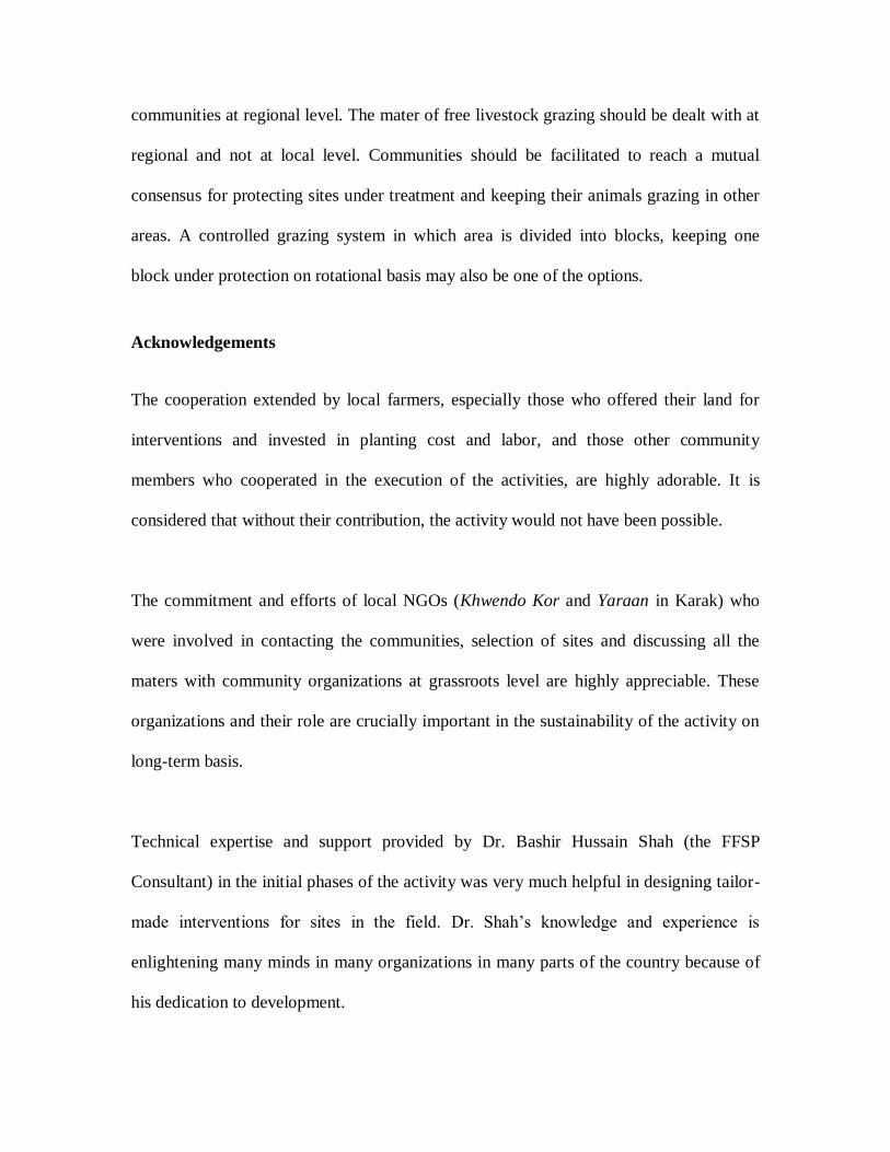
7 COST ANALYSIS
Due to use of specialized instruments and machinery, the cost was very low for applying
hillside ditch technique to the development of silvo-pastures. The total cost including use
of machinery, planting stock, seeds, and labor was calculated as US$ 82 per hectare (see
Table 3).
Table 3: Cost analysis of silvopastures development per 1 hectare of land: SAHIBZADA
(2015)
Activity
Cost
Description
Rate
(Rs)
Amount
(Rs)
Amount
(US$)
Preparation of hillside ditches with
tractor and ditcher
3 Hours 300 900
Total cost
= US $ 82
@ PK Rs.
60/$
Preparation of pits with tractor and pit
blade
2.5 Hour 300 750
Planting stock 540 Plants 2/plnt 1,080
Planting with first watering 540 Plants 2/plnt 1,080
Restocking (30%), including cost of
plants and planting
160 Plants 4/plnt 640
Grass seed 3 Kg 50/kg 150
Seed of shrubs 2 Kg 100 200
Sowing of shrubs’ and grasses’ seeds 1 Labor day 100 100
Total Cost (Rs.) 4,900

It is important to mention that the extra cost involved in this activity was that of using
specialized techniques. This, however, drastically reduced the cost of manual watering as
implied in ordinary plantation activities by the Forest Department or other agencies. The
usual cost per hectare plantation activity by the Forest Department was Rs. 19,800 or
US$ 330 that was considerably higher than the cost on using hillside ditches; (FATA,
2015), (GoKP 2003). The additional benefit of this silvo-pasture development was that it
re-established the whole vegetation cover as compared to ordinary plantation work that
considered only trees.
In case of sand dunes, total cost per hectare of Kana establishment including the cost of
suckers and labour was Rs. 5,000 (US$ US$ 83). The average annual return from Kana
site was Rs. 44,100 (US$ 735) that was profitably comparable with other land uses
available for sand dunes, except wheat (see Table 4 below).
Table 4: Annual cost/benefit per hectare for various crops of sand dunes in Karak; (ARS
Karak, 2015)
Cost/Benefit Kanola (Rs.) Gram (Rs.) Mustard (Rs.) Kana (Rs.)
Annual Cost 6,052 9,139 10,003 -
Annual Income 14,795 53,097 74,055 44,100
Net profit (Rs.) 8,743 43,958 64,052 44,100
Net profit (US$) 146 732 1,067 735
The investment cost for Kana was only one time as this was a perennial plant. It was cut
each year and sprouted again (Figure 11). Both the long stalks and leaves were sold in

market (these were used for furniture making, as roofing material, sunscreens and making
of decoration items). The outstanding characteristic of Kana was that its production did
not depend on rainfall and even did well in prolonged droughts when all other crops
failed.
8 LIMITATIONS AND CONSTRAINTS
The study faced all those constraints common in dealing with a common resource in
social environment. It could have produced better results if the land resource use patterns
were in control of the study team. However it is a fact that more than 60 percent land in
Karak is treated as wasteland where free and unrestricted herding and grazing of animals
is practiced. Due to no or lesser productivity of economic goods, the use rights for
livestock grazing are not reserved. Free, unrestricted and extensive grazing of animals is
thus practiced by local communities, even by those who don’t own any land and totally
depend on their livestock.
The rehabilitation measures however demand care of the land and protection from
grazing for initial two years to provide relief to the recovering vegetation. Due to silvo-
pastoral practices that have become a way of life, it is difficult for land owners to
Fig 10: Harvesting of S. spontaneum

abandon grazing on their land. It is due to this reason that communities usually demand
for fencing the area or keeping watchmen to protect the site which enormously increase
the establishment cost of the activity.
Without attending to the protection parameters, activity in some places have resulted in
no conspicuous results after the planted seedlings and shrubs were completely clean
washed by roaming herds of goats and sheep.
On the other hand, it is a common concept among local people that investing on silvo-
pastures is a profit-less venture. Failures due to water shortage in past and the lack of
protection from free grazing animals have further strengthened this perception. The
already marginalized communities therefore find it very difficult to invest on pasture
development.
To overcome these constraints, the project used a vigorous campaign to convince the
local resource users (herders and farmers) for restricting their herding practices to
untreated lands. The project team ensured in return to limit the treatments to a small
portion (1/4th) of the grazing lands to provide sufficient grazing fields for the herds. At
the same time, a concept of social fencing was used where farmers’ associations in the
target communities and adjacent villages were taken into confidence for the activity and
they were than able to control the un-attended grazing practices.
Whereas this paper addresses the problem faced by a wider population of herdsman and
farmers dependent upon farming and livestock resources in a pattern that is common to
the dry southern landscapes of Pakistan, India and many other adjacent countries, the

land use pattern in dry parts of many other countries may vary and the copy strategies for
all those lands will vary accordingly for producing similar results. This study is therefore
limited in scope keeping in view the resource use patterns.
The study produced visible effects in terms of revamping the biomass reserves of the
area. However the more desired effect on soil fertility and its organic content was not
visible or verifiable in the limited span of this study. For measurable effects in these
parameters, a longer period monitoring is required.
9 CONCLUSIONS
The interventions in silvo-pasture development and sand dune stabilization have proved
significant in overcoming the water shortage and rejuvenating the vegetation for the
benefit of human beings and livestock. The cost of these activities is also very low and
within the bearing capacity of farmers. Every effort has been made to make use of local
instruments and material like the improvised “ditcher” and “pitter” which were the
modified forms of already in-use agricultural implements. The study in the given socio-
economic and geophysical environment produced results that could be of use and interest
to many scientists and practioners working in similar environment and dealing with
similar problems. Particularly the sub-tropical drylands in many neighbouring countries
can be a suitable ground for tackling these problems with these or adjusted techniques.
However, a strategy need to be worked out beforehand to control the constraints
elaborated in the previous section to eliminate or minimize the effects of free grazing.
These facts and results need to be spread wide through extension and mobilization of
communities at regional level. The mater of free livestock grazing should be dealt with at
regional and not at local level. Communities should be facilitated to reach a mutual
consensus for protecting sites under treatment and keeping their animals grazing in other
areas. A controlled grazing system in which area is divided into blocks, keeping one
block under protection on rotational basis may also be one of the options.
Acknowledgements
The cooperation extended by local farmers, especially those who offered their land for
interventions and invested in planting cost and labor, and those other community
members who cooperated in the execution of the activities, are highly adorable. It is
considered that without their contribution, the activity would not have been possible.
The commitment and efforts of local NGOs (Khwendo Kor and Yaraan in Karak) who
were involved in contacting the communities, selection of sites and discussing all the
maters with community organizations at grassroots level are highly appreciable. These
organizations and their role are crucially important in the sustainability of the activity on
long-term basis.
Technical expertise and support provided by Dr. Bashir Hussain Shah (the FFSP
Consultant) in the initial phases of the activity was very much helpful in designing tailor-
made interventions for sites in the field. Dr. Shah’s knowledge and experience is
enlightening many minds in many organizations in many parts of the country because of
his dedication to development.
The author is highly thankful to management of Farm Forestry Support Project, the
Intercooperation-Pakistan Delegation Office and the Swiss Agency for Development and
Cooperation in providing funding resources, logistic support and facilitation in the
execution of the activities in Karak District.
Reference
1. Agriculture Research Station (ARS), Government of Khyber-Pakhtunkhwa
(2015): Agriculture statistics for drylands of Karak. Ahmadwala, District Karak,
Pakistan.
2. Civil Secretariat FATA, Government of Pakistan (GoP 2007): Development of
forestry sector resources for carbon sequestration in FTA, Pakistan.
3. Farm Forestry Support Programme (FFSP); 2015: A case study on water
harvesting and rehabilitation of degraded lands in community owned lands.
Intercooperation-Pakistan, Peshawar, Pakistan.
4. Fischler, M., et al (2006): Dryland management: A perspective for livelihood
improvement in rural areas, Experiences from Pakistan. Intercooperation –
Pakistan, Peshawar.
5. Forest Department, Government of Khyber-Pakhtunkhwa (GoKP 2003): Schedule
of rates (unit cost estimates) for Malakand Forest Circle, Pakistan.
6. Government of Pakistan, GoP (1998): Census Report of District Karak. Provincial
Census Organization, Peshawar.
7. Government of Pakistan, GoP (1998): Census Report of Pakistan. Pakistan
Census Organization, Islamabad.
8. Government of Khyber-Pakhtunkhwa (GoKP) (1998): NWFP Development
Statistics. Bureau of Statistics Planning, Environment and Development
Department, Peshawar, Pakistan.
9. Government of Pakistan (GoP) (2000): Pakistan Agricultural Census Report.
Pakistan Census Organization, Islamabad.
10. Irfanullah, S. (2008): Dryland management and rehabilitation: A case study from
Karak District, Pakistan. Studies in Indian Economy. Volume 3. 108-114.
11. Khattak, Jamal K. (2015): Laboratory analysis of soil samples from dryland
management sites in Karak. Department of soil and environmental sciences,
NWFP University of Agriculture, Peshawar, Pakistan.
12. Government of Pakistan (GoP), Pakistan Meteorological Department (2006):
Annual Normal Rainfall Map of Pakistan, Islamabad, Pakistan.
13. Pakistan Forest Institute (2005): Tree Growth on Farmlands and Wastelands of
Karak, Haripur and Kurram Agency, Pakistan.
14. Pakistan Meteorological Department, Government of Pakistan (1998):
Environmental Profile of Pakistan, Islamabad.
15. Robin, P. W., et al (2002): An ecosystem approach to drylands: Building support
for new development policies, Information Policy Brief No. 1. World Resources
Institute, Washington, DC.
16. Shah, B.H. (2011): Field manual of the role of water harvesting for dryland
management in Pakistan. Intercooperation - Pakistan, Peshawar.

17. United Nations Convention to Combat Desertification (UNCCD) (1999): United
Nations Convention to Combat Desertification in Those Countries Experiencing
Serious Drought and/or Desertification, Particularly in Africa. UNCCD, France.