water resources managementdst-iget.in/assets/pdf/summerschool/jammu_2019.pdf10.5.1 (10 licenses),...
TRANSCRIPT

Winter School in Geospatial Technologies (Level 2)
Organized by
Department of Remote Sensing
University of Jammu,
Jammu and Kashmir
Supported by
National Resources Data Management System
Department of Science and Technology,
Government of India, New Delhi
Water Resources Management 19 November-9 December 2019
University of Jammu, Jammu and Kashmir

University of Jammu
The University of Jammu, accredited as 'A+' Grade
University by National Assessment & Accreditation
Council of India came into existence in 1969 vide
Kashmir and Jammu Universities Act 1969 follow-
ing bifurcation of the erstwhile University of Jammu
and Kashmir. It is located in the city of temples,
Jammu cradled in the lap of mountains at the foot-
hills of auspicious Trikuta hills, besides the river
Tawi at an altitude of 1030 ft.
Department of Remote Sensing
Among several established departments and re-
search centres, the Department of Remote Sensing
& GIS was established in the year 2008 with all the
requisite facilities required for Remote Sensing and
GIS studies. The Remote Sensing & GIS labs are
well equipped with latest softwares of Digital Imag-
es processing and GIS such as ArcGIS Web Server
10.5.1 (10 Licenses), ERDAS Imagine Software
2015 (20 license’s) Arc IMS, Intergraph Advance
RS & GIS Edu. kit for data display and GeoMedia
etc. The number of Remote Sensing and GIS appli-
cationhave been uploaded in the department Site
such as natural resources & watershed management,
Socio Economic and groundwater of the state of
Jammu and Kashmir. There are two permanent and
one contractual faculty members in the department
of Remote Sensing & GIS.
Prof. Avtar Singh Jasrotia, Head
Dr. Ajay Kumar Taloor, Assistant Professor
Dr. Retinder Kour Contractual Lecturer
Infrastructure
The Institute has the various facilities such a very
well equipped laboratory with hardware and soft-
ware relevant to the use of geospatial technologies.
There are three labs in the department well equipped
withPentium IV Core 2 Duo computer with 28work-
stations including two server having Arc GIS Web
Server 10.5.1 (10 Licenses) and ERDAS 2015 with
Imagine ERDAS Virtual GIS (20 license’s) Arc
IMS, Intergraph Advance RS & GIS Edu. kit for
data display and GeoMedia etc, Differential Global
Positioning System (DGPS), Mirror Stereoscopes,
HP Design jet 4500-A0 Scanner, and multi-media
projector. Beside that nos of open source softwares
such as SAGA/QGIS/ILWIS/DIVA-GIS.
Lodging Facilities
Two guest houses are available for lodging purpose
inside the Jammu University, New Campus.
About the Winter School in Geospatial Technol-ogies (Level 2: Water Resources Management)
Winter School (Level 2 - Advanced) on Water Re-
sources Management focusses on developing ca-
pacity and enhancing the perspectives of the geospa-
tial aspects of water resources.
Dates: 19 November - 9 December 2019
Venue: Depar tment of Remote Sensing, Universi-ty of Jammu, Jammu and Kashmir
Principal Investigator : Dr. Avtar Singh Jasrotia, Professor
Address: Depar tment of Remote Sensing & GIS
University of Jammu, Jammu - 180006
Email id: [email protected]
Phone number: +91-9419133793
Website: http://www.jammuuniversity.in/mscgis/about-remote-sensing.html
1

2 Well equipped remote sensing and GIS lab

Course outline of the
Advanced (L2) Winter School in Geospatial Technologies (Water Resources)
Time
Topic
Mode of delivery
Day 1 (19th Nov.) Tuesday
0800-0900 hrs
Registration
0900-1030 hrs
Inauguration session (with plenary talk by chief guest)
1030-1100 hrs
High tea
1100-1200 hrs
1.1 Introduction of the group (trainers and trainees)
Verbal introduction
Expectations from the training program
Why they joined this training program?
Making groups for reporting, grading of the course
Each trainee has to vocally express their opinions
1200-1300 hrs
1.2 Geospatial Sciences: What, why and how??
Moving from data to information
Lecture delivery using PowerPoint
1300-1400 hrs
Lunch
1400-1600 hrs
1.3 GIScience Education in National and International Status
Interactive talk using audio visual

1600-1615hrs
Tea break
1615-1715hrs
1.4 Exercise 1
Data Acquisition
• Registration in different portals: Bhuvan, USGS Earth
Explorer, Earth Data
• Downloading of Landsat, MODIS, IRS, acquiring
toposheets from SOI
Access Geoportal of Jammu University
Ppt demonstrating downloading steps with
follow up exercise for participants to
download specific data.
Use following address to assess Geoportal of
Jammu University
(http://www.jammuuniversity.in/mscgis/)
1715-1730hrs
1.5 Filling in feedback forms
Groups of participants will report over the
duration of the training with one participant
responsible within each group to get feedback

Day 2 (20th Nov.) Wednesday
0930-1100hrs
2.1 Fundamentals of remote sensing
• Electromagnetic radiation (EMR) and electromagnetic
spectrum (EMS)
• Types of resolution
Lecture delivery via PowerPoint
1100-1130 hrs Tea break
1130-1300hrs
2.2 Digital image processing applications in water resources
• Image rectification
• Image enhancement
• Image classification
• Data merging
Interactive talk/discussion using audio visual
1300-1400 hrs
Lunch
1400-1600 hrs
2.3 Exercise 2
Overview of QGIS, ILWIS, DIVA-GIS
Open raster layers
Layerstacking
Mosaicking
Hands-on lab using different softwares
1600-1615hrs
Tea break
1615-1715hrs
2.4 Exercise 2
Digital image processing
• Histogram equalization
• Low pass filter
• High pass filter
• Supervised classification
• Unsupervised classification
Hands-on exercises hosted on the workstations
1715-1730hrs
2.5 Feedback by the trainees
Groups of participants will report over the duration of
the training with one participant responsible within
each group to get feedback

Day 3 (21st Nov.) Thursday
0930-1100 hrs
3.1 Understanding data quality
• Elements of data quality
• Sources and types of errors in geospatial data
building
Sharing expert’s views/opinion through
PowerPoint slides
1100-1130 hrs Tea break
1130-1300 hrs
3.2 Understanding data quality contd.
• Importance of metadata
• Integrating spatial and non-spatial data
Content delivery via PowerPoint slides
1300-1400 hrs Lunch
1400-1600 hrs
3.3 Exercise 3
Vector layer generation
• Generation of vector layers
• Digitization
Students should generate the outputs in their
respective folders in the workstation
1600-1615 hrs Tea break
1615-1715 hrs
3.4 Exercise 3 contd.
Vector layer generation
• Attribute entry
• Attribute query
Performance of exercises using software in the
lab
1715-1730 hrs
3.5 Fill in feedback forms
Groups of participants will report over the
duration of the training with one participant
responsible within each group to get feedback

Day 4 (22nd Nov.) Friday
0930-1100 hrs
4.1 Fundamentals of Thermal Remote Sensing
Thermal remote sensing: Introduction and characteristics
Thermal radiation principles
Audio visual discussion/interactivetalk
1100-1130 hrs Tea break
1130-1300 hrs
4.2 Fundamentals of Thermal Remote Sensing (contd.)
Thermal properties of materials
Applications of thermal data
Advantages and disadvantages
Sharing the general concepts by the expert via
PowerPoint slides
1300-1400 hrs
Lunch
1400-1600 hrs 4.3 Exercise 4
Thermal image processing (Snow Hydrology)
Conversion of DN to TOA spectral radiance
Performance of practical with the help of
workstation and Open source software/Erdas
Imagine software
1600-1615 hrs Tea break
1615-1715 hrs
4.4 Exercise 4 contd.
Thermal image processing (Snow Hydrology)
Conversion of TOA spectral radiance to TOA Brightness
Temperature
Trainees should save the outputs in the derives of
their respective workstations
1715-1730 hrs 4.5 Fill in feedback forms Groups of participants will report over the
duration of the training with one participant
responsible within each group to get feedback

Day 5 (23rd Nov.) Saturday
0930-1100 hrs
5.1 Fundamentals of microwave remote sensing
• Characteristics of microwave remote sensing
• Passive & active microwave sensors
Sharing the general concept by means of
PowerPoint slides
1100-1130 hrs Tea break
1130-1300 hrs
5.2 Fundamentals of microwave remote sensing (contd.)
• SAR
• SLAR
• Radar image interpretation
Audio visual discussion/interactive talk
1300-1400 hrs Lunch
1400-1600 hrs
5.3 Exercise 5
Hydrology parameters retrieval using Microwave Remote Sensing
• Rainfall
• Soil Moisture
• Flood
Instruction through demo mode on the
workstation
1600-1615 hrs Tea break
1615-1715 hrs
5.4 Exercise 5 contd.
Performance of exercises by the participants on
their respective workstations
1715-1730 hrs 5.5 Fill in feedback forms Groups of participants will report over the
duration of the training

Day 6 (24th Nov.) Sunday
0930-1730 hrs Field trip in and around Jammu Himalaya
Day 7 (25th Nov.) Monday
0930-1100 hrs
6.1 Global Positioning System (GPS)
• Principle of GPS
• GPS Segments
Interactive talk/discussion with PowerPoint
1100-1130 hrs Tea break
1130-1300 hrs
6.2 Global Positioning System (GPS) contd.
• Accuracy and precision in GPS
• DGPS Survey Techniques
Content delivery via PowerPoint slides
1300-1400 hrs
Lunch
1400-1600 hrs
6.3 DGPS Survey in and around Jammu university campus
• Collection of waypoints
Field exercise for collecting waypoints
1600-1615 hrs Tea break
1615-1715 hrs
6.4 DGPS survey contd.
• Importing GPS data into software
• Drape GPS points over imagery
Importing data in the workstations
1715-1730 hrs 6.5 Fill in feedback forms Groups of participants will report over the
duration of the training

Day 8 (26th Nov.) Tuesday
0930-1100 hrs
8.1 Hydrologic cycle
• Precipitation and its types
• Infiltration
Interactivetalk/discussion by
invited speakers using power
point
1100-1130 hrs Tea break
1130-1300 hrs
8.2 Hydrologic cycle contd.
• Evaporation
• Interception
• Runoff
Guest lecture
1300-1400 hrs Lunch
1400-1600 hrs
8.3 Exercise 8
Estimation of potential evapotranspiration and water balance through
empiricalequation
Exercise to be done by the trainees on
Microsoft Excel
1600-1615 hrs Tea break
1615-1715 hrs 8.4 Exercise 8 contd. Computations will be done using
Microsoft Excel
1715-1730 hrs
8.5 Fill in feedback forms
Groups of participants will report
over the duration of the training

Day 9 (27th Nov.) Wednesday
0930-1100 hrs
9.1 Basic of Groundwater Hydrology
• Porosity
• Permeability
• Transmissibility
• Specific yield
• Specific retention
• Hydraulic conductivity
Interactivetalk/discussion by
invited speakers using power
point
1100-1130 hrs Tea break
1130-1300 hrs
9.2 Types of aquifers and its location in different geological formations
• Aquiclude
• Aquitard
• Aquifuge
Guest lecture
1300-1400 hrs Lunch
1400-1600 hrs
9.3 Exercise 9
• Terrain characterization
• Aquifer parameters
Practical exercises to be performed on
workstations
1600-1615 hrs Tea break
1615-1715 hrs
9.4 Exercise 9
Hydromorphologeologic interpretation
Preparation of groundwater potential zone maps
Practical exercise
1715-1730 hrs
9.5 Fill infeedbackforms
Groups of participants will report
over the duration of the training

Day 10 (28th Nov.) Thursday
0930-1100 hrs
10.1 Watershed management and conservation
• Concept of watershed: Watershed delineation, conservation,
planning and management
Interactivetalk/discussion by
invited speakers using power
point
1100-1130 hrs Tea break
1130-1300 hrs
10.2 Watershed management and conservation contd.
• Runoff estimates from watersheds & GIS database for watershed
management
Guest lecture
1300-1400 hrs Lunch
1400-1600 hrs
10.3 Exercise 10
Watershed characteristics
• Watershed delineation
• Morphometric analysis
Exercise to be performed on the
workstation
1600-1615 hrs Tea break
1615-1715 hrs 10.4 Exercise 10 contd. Lab exercise
1715-1730 hrs
10.5 Fill in feedback forms
Groups of participants will report
over the duration of the training

Day 11 (29th Nov.) Friday
0930-1100 hrs
11.1 Spectral characteristics of water and relevance of
Remote Sensing techniques for hydrological
investigations
Interactivetalk/discussion by
invited speakers using power
point
1100-1130 hrs Tea break
1130-1300 hrs
11.2 Subsurface geophysical methods of Groundwater
exploration
Guest lecture
1300-1400 hrs Lunch
1400-1600 hrs
11.3 Exercise 11
• Spectral characteristics and comparison of fresh, saline, deep and
shallow water body
Exercise to be performed on the
workstation
1600-1615 hrs Tea break
1615-1715 hrs
11.4 Exercise 11 contd.
2 D and 3D subsurface information through Resistivity Imaging
Tomography system for delineating aquifer thickness and
estimation of groundwater flow
1715-1730 hrs
11.5 Fill infeedbackforms
Groups of participants will report
over the duration of the training

Day 12 (30th Nov.) Saturday
0930-1100 hrs 12.1 Role of Remote Sensing & GIS in flood monitoring and
management
• Basic concept and causes
• Monitoring of floods: Remote Sensing datasets used
Interactivetalk/discussion by invited
speakers using power point
1100-1130 hrs Tea break
1130-1300 hrs
12.2 Role of Remote Sensing & GIS in flood monitoring and
management contd.
• Management of floods: Change detection and management
Guest lecture
1300-1400 hrs Lunch
1400-1600 hrs
12.3 Exercise 12
• Flood hazard zonation mapping:A GIS approach
Exercise to be performed on the
workstation
1600-1615 hrs Tea break
1615-1715 hrs 12.4 Exercise 12 contd. Trainees should save the outputs in the
derives of their respective workstations
1715-1730 hrs
12.5 Fill infeedbackforms
Groups of participants willreport over
theduration ofthe training

Day 13 (1st Dec.) Sunday
0930-1100 hrs Discussion of possible pilot projects to be done by the participants
according to the data availability and interest of the trainee
1100-1130hrs Tea break
1130-1300 hrs Allotment of projects (group-wise)
1300-1400 hrs Lunch
1400-1530 hrs Working on the allotted project topic

Day 14 (2nd Dec.) Monday
0930-1100 hrs
13.1 Rain water harvesting
• Rain water harvesting: Concept and water harvesting structures
Interactivetalk/discussion by
invited speakers using power point
1100-1130 hrs Tea break
1130-1300 hrs
13.2 Rain water harvesting contd.
• Optimum site selection for rain water harvesting
Guest lecture
1300-1400 hrs Lunch
1400-1600 hrs
13.3 Exercise 13
DEM-Hydro processing
• Flow direction
• Drainage network
• Sub-basin delineation
• Water harvesting structures
Exercise to be performed on the
workstation
1600-1615 hrs Tea break
1615-1715 hrs 13.4 Exercise 13 contd.
Modelling
• SCS
• Revised Universal Soil Loss Equation (RUSLE)
• Morgan–Morgan–Finney mathematicalmodel
Trainees should save the outputs in the
derives of their respective workstations
1715-1730 hrs
13.5 Fill infeedbackforms
Groups of participants will report over
the duration of the training

Day 15 (3rd Dec.) Tuesday
0930-1100 hrs
15.1 Groundwater: General overview and groundwater provinces of
India
Interactive talk/discussion by invited
speakers using power point
1100-1130 hrs Tea break
1130-1300 hrs
15.2 Physical and chemical properties of water quality criteria for
domestic, irrigation and industrialuse
Graphical presentation of water quality data
Guest lecture
1300-1400 hrs Lunch
1400-1600 hrs
15.3 Exercise 15
• Presentation of Hydro-geochemical data in the GIS
environment
• Flow net analysis
Trainees should save the outputs in the
derives of their respective workstations
1600-1615 hrs Tea break
1615-1715 hrs 15.4 Exercise 15 contd. Exercise to be performed on the
workstation
1715-1730 hrs
15.5 Fill in feedback forms
Groups of participants will report over
the duration of the training

Day 16 (4th Dec.) Wednesday
0930-1100 hrs
16.1 Snow/Glacier hydrology
• Elements of snow hydrology
• Snow in visible spectrum, middle infrared and microwave
regions
• Mass balance estimation
Interactivetalk/discussion with
power point
1100-1130 hrs Tea break
1130-1300 hrs
16.2 Snow/Glacier hydrology contd.
• Snow water equivalent estimation
• Factors influencing snow melt
• Snowmelt runoff modeling
Guest lectures
1300-1400 hrs Lunch
1400-1600 hrs
16.3 Exercise 16
Hydrological models (SWAT, HBV and VIC)
• Generation of input layers such as meteorological files,
LULC maps and observed discharge data in software
supporting formats
Performance of exercise on workstation
1600-1615 hrs Tea break
1615-1715 hrs
16.4 Exercise 16 contd.
Hydrological models (SWAT, HBV and VIC)
Generation of hydrographs depicting the impact of climate
change on snowmelt runoff
Output generation in respective folders of
the trainee
1715-1730 hrs
16.5 Feedback
Groups of participants will report over
the duration of the training with one
participant responsible within each group
to get feedback

Day 17 (5th Dec.) Thursday
0930-1100 hrs
17.1 Irrigation water management
Irrigation in India
Irrigation efficiency and scheduling
Interactive session through ppt.
1100-1130 hrs Tea break
1130-1300 hrs
17.2 Irrigation water management contd.
Irrigation command area mapping and monitoring
Suggestive measures for increasing water use efficiency by crop and
soil management practices
Guest lectures
1300-1400 hrs Lunch
1400-1600 hrs
17.3 Exercise 17
Irrigation and command area modeling (ILWIS and QGIS)
Calculation of the required irrigation for a particular area using
simple water balance approach in ILWIS
Assessment of irrigation pattern using HidroMap tool in QGIS
Performance of exercise on
workstation
1600-1615 hrs
Tea break
1615-1715 hrs
17.4 Exercise 17 contd.
Irrigation and command area modeling (Crop Wat 8.0)
Calculation of evapotranspiration, crop water requirement, crop
irrigation requirement using observed datasets such as crop
evapotranspiration, monthly rainfall, soil type and crop pattern
Outputs should be saved in the
respective folders in the workstation
1715-1730 hrs
17.5 Trainee feedback
Groups of participants will report
over the duration of the training
with one participant responsible
within each group to get feedback
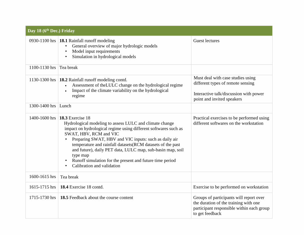
Day 18 (6th Dec.) Friday
0930-1100 hrs
18.1 Rainfall runoff modeling
• General overview of major hydrologic models
• Model input requirements
• Simulation in hydrological models
Guest lectures
1100-1130 hrs Tea break
1130-1300 hrs
18.2 Rainfall runoff modeling contd.
Assessment of theLULC change on the hydrological regime
Impact of the climate variability on the hydrological
regime
Must deal with case studies using
different types of remote sensing
Interactive talk/discussion with power
point and invited speakers
1300-1400 hrs Lunch
1400-1600 hrs
18.3 Exercise 18
Hydrological modeling to assess LULC and climate change
impact on hydrological regime using different softwares such as
SWAT, HBV, RCM and VIC
• Preparing SWAT, HBV and VIC inputs: such as daily air
temperature and rainfall datasets(RCM datasets of the past
and future), daily PET data, LULC map, sub-basin map, soil
type map
• Runoff simulation for the present and future time period
• Calibration and validation
Practical exercises to be performed using
different softwares on the workstation
1600-1615 hrs Tea break
1615-1715 hrs
18.4 Exercise 18 contd.
Exercise to be performed on workstation
1715-1730 hrs
18.5 Feedback about the course content
Groups of participants will report over
the duration of the training with one
participant responsible within each group
to get feedback

Day 19 (7th Dec.) Saturday
0930-1100 hrs Working on respective allotted projects
1100-1130 hrs Tea break
1130-1300 hrs Resume pilot project work
1300-1400 hrs Lunch
1400-1530 hrs Continuation of the project work
Day 20 (8th Dec) Sunday
0930-1100 hrs Recommence respective pilot projects
1100-1130 hrs Tea break
1130-1300 hrs Continuation of the pilot projects by the trainees
1300-1400 hrs Lunch
1400-1530 hrs Project work completion
Day 21 (9th Dec.) Monday
0930-1100 hrs Final pilot project presentation by participants
1100-1130hrs Tea break
1130-1300 hrs Continuation of project presentation
1300-1400 hrs Lunch
1400-1530 hrs Feedback and Valedictory