water cycle management guidelines - lake … · water cycle management guideline water cycle...
TRANSCRIPT
WATER CYCLE MANAGEMENT GUIDELINES
Revision 2
June 2013
Water Cycle Management Guideline
Water Cycle Management Guideline – Revision 2 Page 2 – F2009/00952 Adopted by Council 11 June 2013
TABLE OF CONTENTS:
1 EXECUTIVE SUMMARY.....................................................................................................5
2 INTRODUCTION .................................................................................................................7
3 SECTION 1 – CITY OF LAKE MACQUARIE’S URBAN WATER SYSTEM......................8 3.1 City of Lake Macquarie Waterways ..............................................................................9 3.2 Water Management Drivers ..........................................................................................9
3.2.1 Water supply 10 3.2.2 Water demand 10 3.2.3 Water Quality 10 3.2.4 Volume & timing 11
4 SECTION 2 – REPORTING REQUIREMENTS FOR DEVELOPMENT APPLICATIONS12 4.1 Site Stormwater Drainage Plan...................................................................................12
4.1.1 Additional Considerations for Single Dwellings & Dual Occupancies 13 4.2 Water Cycle Management Plan ..................................................................................15
5 SECTION 3 – DEVELOPING A WATER CYCLE MANAGEMENT PLAN.......................16 5.1 Guiding Principles .......................................................................................................16
5.1.1 Steps to achieving integrated water cycle management 16 5.1.2 STEP 1 – Consider the site context 17
5.2 STEP 2 – Find ways to reduce water consumption ....................................................18 5.2.1 Water Saving Targets 18
5.3 STEP 3 – Replace potable water with an alternative water source............................19 5.4 STEP 4 – Managing stormwater before discharge into waterways ............................20
5.4.1 Stormwater Management Targets 20 5.4.2 Stormwater treatment measures 20
5.5 Watercourse Rehabilitation .........................................................................................23 5.5.1 Objectives and Principles of riparian rehabilitation 23 5.5.2 Protecting Existing Vegetation & new plantings 23 5.5.3 Protect the natural morphology of the watercourse 23
5.6 STEP 5 – UNDERTAKE WATER CYCLE MANAGEMENT DESIGN........................24 5.6.1 Modelling of design options 24 5.6.2 Considering Water Cycle Management in the broader environment 24 5.6.3 Application of WCM to development type 25 5.6.4 Single allotment and small residential subdivision 25 5.6.5 Medium and high density residential development 26 5.6.6 Large Greenfield subdivisions 27 5.6.7 Commercial and Industrial 28
Water Cycle Management Guideline
Water Cycle Management Guideline – Revision 2 Page 3 – F2009/00952 Adopted by Council 11 June 2013
5.6.8 Infrastructure 30 5.6.9 OPERATION & MAINTENANCE 31
6 APPENDICES ...................................................................................................................32 6.1 Appendix 1 - Calculating the Site Discharge Index....................................................32 6.2 Appendix 2 – Using mitigation depth to calculate storage requirements...................34
Water Cycle Management Guideline
Water Cycle Management Guideline – Revision 2 Page 4 – F2009/00952 Adopted by Council 11 June 2013
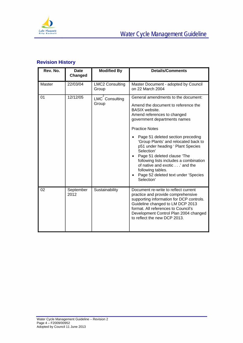
Revision History
Rev. No. Date Changed
Modified By Details/Comments
Master 22/03/04 LMC2 Consulting Group
Master Document - adopted by Council on 22 March 2004
01 12/12/05 LMC2 Consulting
Group General amendments to the document:
Amend the document to reference the BASIX website. Amend references to changed government departments names Practice Notes
• Page 51 deleted section preceding ‘Group Plants’ and relocated back to p51 under heading ‘ Plant Species Selection’
• Page 51 deleted clause ‘The following lists includes a combination of native and exotic . . .’ and the following tables.
• Page 52 deleted text under ‘Species Selection’
02 September
2012 Sustainability Document re-write to reflect current
practice and provide comprehensive supporting information for DCP controls. Guideline changed to LM DCP 2013 format. All references to Council’s Development Control Plan 2004 changed to reflect the new DCP 2013.
Water Cycle Management Guideline
Water Cycle Management Guideline – Revision 2
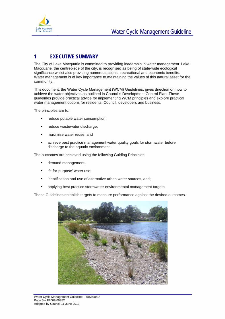
1 EXECUTIVE SUMMARY The City of Lake Macquarie is committed to providing leadership in water management. Lake Macquarie, the centrepiece of the city, is recognised as being of state-wide ecological significance whilst also providing numerous scenic, recreational and economic benefits. Water management is of key importance to maintaining the values of this natural asset for the community.
This document, the Water Cycle Management (WCM) Guidelines, gives direction on how to achieve the water objectives as outlined in Council’s Development Control Plan. These guidelines provide practical advice for implementing WCM principles and explore practical water management options for residents, Council, developers and business.
The principles are to:
reduce potable water consumption;
reduce wastewater discharge;
maximise water reuse; and
achieve best practice management water quality goals for stormwater before discharge to the aquatic environment.
The outcomes are achieved using the following Guiding Principles:
demand management;
‘fit-for-purpose’ water use;
identification and use of alternative urban water sources, and;
applying best practice stormwater environmental management targets.
These Guidelines establish targets to measure performance against the desired outcomes.
Page 5 – F2009/00952 Adopted by Council 11 June 2013
Water Cycle Management Guideline
Water Cycle Management Guideline – Revision 2 Page 6 – F2009/00952 Adopted by Council 11 June 2013
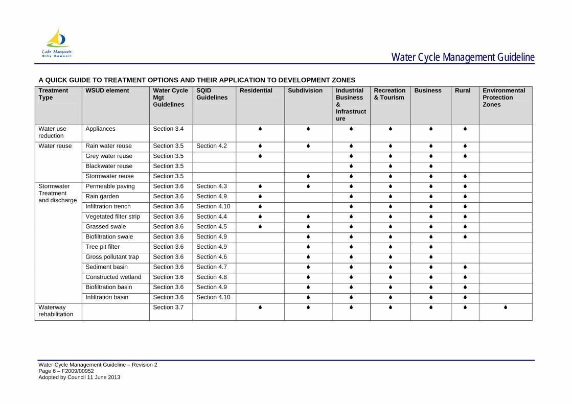
A QUICK GUIDE TO TREATMENT OPTIONS AND THEIR APPLICATION TO DEVELOPMENT ZONES Treatment Type
WSUD element Water Cycle Mgt Guidelines
SQID Guidelines
Residential
Subdivision Industrial Business & Infrastructure
Recreation & Tourism
Business Rural Environmental Protection Zones
Water use reduction
Appliances Section 3.4
Rain water reuse Section 3.5 Section 4.2 Grey water reuse Section 3.5 Blackwater reuse Section 3.5
Water reuse
Stormwater reuse Section 3.5 Permeable paving Section 3.6 Section 4.3 Rain garden Section 3.6 Section 4.9 Infiltration trench Section 3.6 Section 4.10 Vegetated filter strip Section 3.6 Section 4.4 Grassed swale Section 3.6 Section 4.5 Biofiltration swale Section 3.6 Section 4.9 Tree pit filter Section 3.6 Section 4.9 Gross pollutant trap Section 3.6 Section 4.6 Sediment basin Section 3.6 Section 4.7 Constructed wetland Section 3.6 Section 4.8 Biofiltration basin Section 3.6 Section 4.9
Stormwater Treatment and discharge
Infiltration basin Section 3.6 Section 4.10 Waterway rehabilitation
Section 3.7
Water Cycle Management Guideline
Water Cycle Management Guideline – Revision 2 Page 7 – F2009/00952 Adopted by Council 11 June 2013
2 INTRODUCTION These guidelines support the Lake Macquarie City Council Development Control Plan (DCP) and aim to promote Water Cycle Management (WCM) in all development. The guidelines detail how residents, businesses and Council can achieve the water saving and water quality targets outlined within the DCP and Council’s Environmental Sustainability Action Plan.
WCM utilises a range of measures that are designed to avoid, or at least minimise the impacts of urbanisation on the natural water cycle. By incorporating WCM measures in the design and planning of development, it is possible to:-
Reduce flood risk in urban areas
Reduce erosion of waterways, slopes and banks
Improve water quality in the lake, creeks and groundwater
Make more efficient use of water resources
Reduce the cost of providing and maintaining water infrastructure
Protect and restore aquatic and riparian ecosystems and habitats
Protect the scenic, landscape and recreational values of streams
This document is structured into three main sections:
Section 1 examines the principles of WCM and its application to the City of Lake Macquarie’s sustainability objectives.
Section 2 outlines the reporting requirements for WCM when submitting a Development Application for various scale developments.
Section 3 provides practical advice on planning and designing a WCM system.
Water Cycle Management Guideline
Water Cycle Management Guideline – Revision 2
3 SECTION 1 – CITY OF LAKE MACQUARIE’S URBAN WATER SYSTEM
In effect, there are three separate water systems operating in the City of Lake Macquarie’s urban areas. These include:
1. potable water mains water supply – piped system delivering water treated to drinking water standard from catchments outside the urban area.
2. sewerage system – piped system collecting and transporting domestic and industrial wastewater to treatment plants and discharged to the ocean or recycled.
3. stormwater system – a mixed system including surface flowpaths and waterways as well as underground piped systems, transporting stormwater and other natural sources of water to local creeks, Lake Macquarie and the ocean.
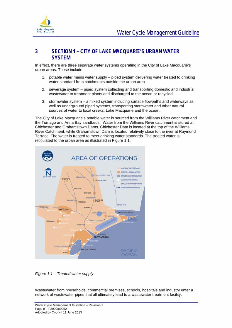
The City of Lake Macquarie’s potable water is sourced from the Williams River catchment and the Tomago and Anna Bay sandbeds. Water from the Williams River catchment is stored at Chichester and Grahamstown Dams. Chichester Dam is located at the top of the Williams River Catchment, while Grahamstown Dam is located relatively close to the river at Raymond Terrace. The water is treated to meet drinking water standards. The treated water is reticulated to the urban area as illustrated in Figure 1.1.
Figure 1.1 – Treated water supply
Wastewater from households, commercial premises, schools, hospitals and industry enter a network of wastewater pipes that all ultimately lead to a wastewater treatment facility.
Page 8 – F2009/00952 Adopted by Council 11 June 2013
Water Cycle Management Guideline
Water Cycle Management Guideline – Revision 2 Page 9 – F2009/00952 Adopted by Council 11 June 2013
Wastewater treatment facilities within the City of Lake Macquarie include Belmont, Dora Creek, Edgeworth and Toronto. Effluent from these treatment plants is either discharged to the ocean or recycled for irrigation or industrial use.
Rainfall on urban catchments (urban stormwater) is collected by a separate network of underground pipes with the majority of the catchment area discharging directly into Lake Macquarie, the ocean or nearby receiving creeks.
Traditional water supply, stormwater and wastewater practises are largely based on centralised collection, rapid conveyance and treatment of water flows. Whilst highly effective, these methods can also have major drawbacks such as inefficient use of water resources, environmental degradation and rising infrastructure costs. By contrast, WCM is based on a more de-centralised approach that is more attuned to natural hydrological and ecological processes.
3.1 CITY OF LAKE MACQUARIE WATERWAYS Lake Macquarie is one of the largest coastal seaboard lagoons in Australia, with a surface area of approximately 110km2, and a foreshore length of 195km. The Lake Macquarie estuary has been identified in numerous State Government plans as being of State-wide ecological significance. Specifically,
Lake Macquarie is the largest wave dominated barrier estuary in NSW; Lake Macquarie contains the third largest area of seagrass in NSW, including the
threatened species Posidonia australis; Lake Macquarie contains significant areas of rocky reef, sandy and muddy habitats;
and Lake Macquarie is rated has having the largest area of significant shorebird locations
in the bioregion. In addition to it’s ecological attributes, Lake Macquarie provides a range of scenic, recreational and economic values to the community. A catchment area of approximately 605 km2 drains to Lake Macquarie via a network of thousands of watercourses, varying in size from large creeks such as Cockle Creek, Winding Creek and Dora Creek to small roadside drains. Dora Creek drains a relatively natural landscape from the Watagan Mountains and Martinsville, while Winding Creek drains the established and urbanised areas of Charlestown, Cardiff, and Glendale. The catchment area of Cockle Creek is progressively becoming more urbanised through residential development in Edgeworth and Cameron Park.
There are a range of water pollution and degradation issues confronting the City of Lake Macquarie’s rivers, creeks and ocean. This includes pollution from urban run-off, erosion from inappropriate land and water management, and erosion caused by loss of vegetation along creek banks.
Better management of stormwater in the City of Lake Macquarie will help to improve the water quality of Lake Macquarie itself and the city’s beaches. WCM provides a proactive, proven way to mitigate pollution from our city’s urban development and provides strategies for continual water improvement.
3.2 WATER MANAGEMENT DRIVERS There are a number of inter-related drivers for water management and the sustainable management of water resources. Water supply, demand, quality and volume are all driven and influenced by population, climate change, human health and environmental impacts.
Water Cycle Management Guideline
Water Cycle Management Guideline – Revision 2 Page 10 – F2009/00952 Adopted by Council 11 June 2013
3.2.1 WATER SUPPLY The City of Lake Macquarie’s demand for water is increasing with population growth. The population is expected to grow by 60,000 people over the next 25 years, creating demand for approximately 36,000 new dwellings. The City has been fortunate to avoid the recent drought experienced by much of NSW. However, water supply in the lower Hunter is highly vulnerable to drought. Water levels can drop faster than in most other major Australian urban centres during drought, because lower Hunter storages are small, or shallow and have high evaporation rates (Hunter Water website 2012).
3.2.2 WATER DEMAND The City of Lake Macquarie residents are already efficient water users, but with a growing population these efforts need to continue. Hunter Water is addressing water security by continuing its focus on recycling and water conservation initiatives including residential and business water efficiency and loss minimization (Hunter Water website 2012).
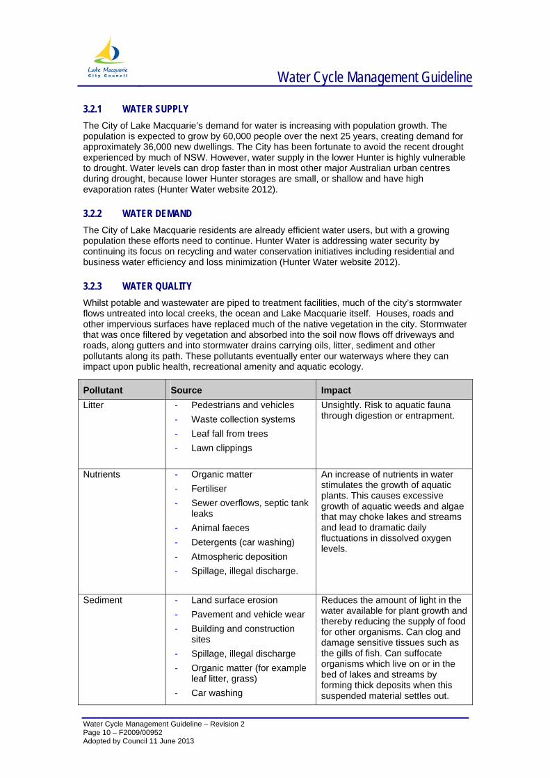
3.2.3 WATER QUALITY Whilst potable and wastewater are piped to treatment facilities, much of the city’s stormwater flows untreated into local creeks, the ocean and Lake Macquarie itself. Houses, roads and other impervious surfaces have replaced much of the native vegetation in the city. Stormwater that was once filtered by vegetation and absorbed into the soil now flows off driveways and roads, along gutters and into stormwater drains carrying oils, litter, sediment and other pollutants along its path. These pollutants eventually enter our waterways where they can impact upon public health, recreational amenity and aquatic ecology.
Pollutant Source Impact Litter - Pedestrians and vehicles
- Waste collection systems - Leaf fall from trees - Lawn clippings
Unsightly. Risk to aquatic fauna through digestion or entrapment.
Nutrients - Organic matter - Fertiliser - Sewer overflows, septic tank
leaks - Animal faeces - Detergents (car washing) - Atmospheric deposition - Spillage, illegal discharge.
An increase of nutrients in water stimulates the growth of aquatic plants. This causes excessive growth of aquatic weeds and algae that may choke lakes and streams and lead to dramatic daily fluctuations in dissolved oxygen levels.
Sediment - Land surface erosion - Pavement and vehicle wear - Building and construction
sites - Spillage, illegal discharge - Organic matter (for example
leaf litter, grass) - Car washing
Reduces the amount of light in the water available for plant growth and thereby reducing the supply of food for other organisms. Can clog and damage sensitive tissues such as the gills of fish. Can suffocate organisms which live on or in the bed of lakes and streams by forming thick deposits when this suspended material settles out.
Water Cycle Management Guideline
Water Cycle Management Guideline – Revision 2 Page 11 – F2009/00952 Adopted by Council 11 June 2013
Pollutant Source Impact - Weathering of
buildings/structures - Atmospheric deposition
Heavy Metals - Atmospheric deposition - Vehicle wear - Sewer overflows, septic tank
leaks - Weathering of buildings,
structures - Spillage, illegal discharges
Poison living organisms or damage their life processes in some other way. Persists in the environment for a long time.
Micro-organics - Animal faeces - Sewer overflows, septic tank
leaks - Organic matter decay.
Contain very high numbers of bacteria and viruses. Some of these organisms can cause illnesses, including hepatitis and gastroenteritis.
Oils, detergents and shampoos (surfactants)
- Asphalt pavements - Spillage, illegal discharges - Leaks from vehicles - Car washing - Organic matter
Highly toxic poison to fish and other aquatic life.
3.2.4 VOLUME & TIMING Because impervious surfaces (parking lots, roads, buildings, compacted soil) do not allow rain to infiltrate into the ground, more runoff is generated than in the undeveloped condition. This additional runoff can erode watercourses (streams and rivers) as well as cause flooding after the stormwater collection system is overwhelmed by the additional flow. Because the water is flushed out of the watershed during the storm event, little infiltrates the soil, replenishes groundwater, or supplies stream baseflow in dry weather. This can effect ecological communities that are dependent on natural flow regimes.
Integrated water quality solutions are required to ensure a secure and reliable water supply, and to maintain healthy ecosystems.
Water Cycle Management Guideline
Water Cycle Management Guideline – Revision 2 Page 12 – F2009/00952 Adopted by Council 11 June 2013
4 SECTION 2 – REPORTING REQUIREMENTS FOR DEVELOPMENT APPLICATIONS
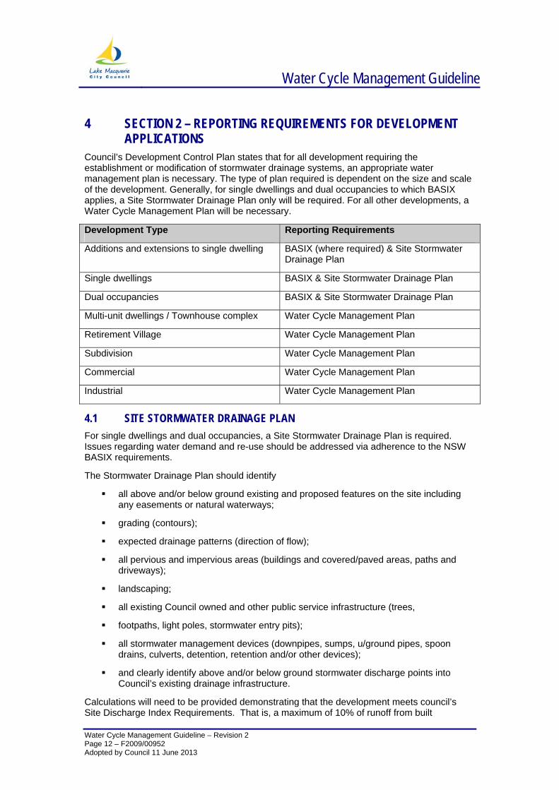
Council’s Development Control Plan states that for all development requiring the establishment or modification of stormwater drainage systems, an appropriate water management plan is necessary. The type of plan required is dependent on the size and scale of the development. Generally, for single dwellings and dual occupancies to which BASIX applies, a Site Stormwater Drainage Plan only will be required. For all other developments, a Water Cycle Management Plan will be necessary.
Development Type Reporting Requirements
Additions and extensions to single dwelling BASIX (where required) & Site Stormwater Drainage Plan
Single dwellings BASIX & Site Stormwater Drainage Plan
Dual occupancies BASIX & Site Stormwater Drainage Plan
Multi-unit dwellings / Townhouse complex Water Cycle Management Plan
Retirement Village Water Cycle Management Plan
Subdivision Water Cycle Management Plan
Commercial Water Cycle Management Plan
Industrial Water Cycle Management Plan
4.1 SITE STORMWATER DRAINAGE PLAN For single dwellings and dual occupancies, a Site Stormwater Drainage Plan is required. Issues regarding water demand and re-use should be addressed via adherence to the NSW BASIX requirements.
The Stormwater Drainage Plan should identify
all above and/or below ground existing and proposed features on the site including any easements or natural waterways;
grading (contours);
expected drainage patterns (direction of flow);
all pervious and impervious areas (buildings and covered/paved areas, paths and driveways);
landscaping;
all existing Council owned and other public service infrastructure (trees,
footpaths, light poles, stormwater entry pits);
all stormwater management devices (downpipes, sumps, u/ground pipes, spoon drains, culverts, detention, retention and/or other devices);
and clearly identify above and/or below ground stormwater discharge points into Council’s existing drainage infrastructure.
Calculations will need to be provided demonstrating that the development meets council’s Site Discharge Index Requirements. That is, a maximum of 10% of runoff from built
Water Cycle Management Guideline
Water Cycle Management Guideline – Revision 2
impermeable surfaces may be discharged directly to the drainage system. The remaining 90% of runoff must be captured for reuse, or managed through infiltration and retention measures prior to being discharged to the drainage system. Please refer to Appendix 1 of this guideline for further information on calculating the Site Discharge Index.
4.1.1 ADDITIONAL CONSIDERATIONS FOR SINGLE DWELLINGS & DUAL OCCUPANCIES ‐ Protection of Watercourse and Drainage Policy
Where a watercourse or drainage line traverses or adjoins a property, consideration should be given to Councils “Protection of Watercourses and Drainage Channels Policy”. The policy states –
Watercourses and their associated vegetation should, unless extraordinary circumstances apply, be left undisturbed, without redirection, re-shaping or modification.
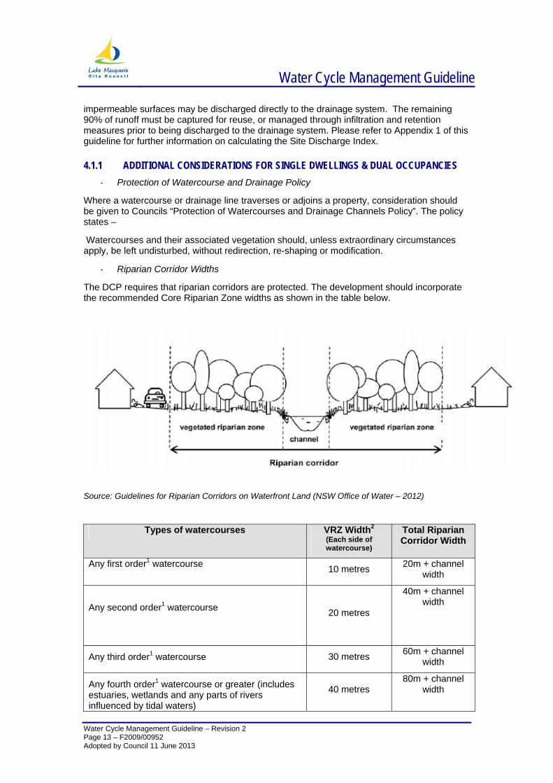
‐ Riparian Corridor Widths
The DCP requires that riparian corridors are protected. The development should incorporate the recommended Core Riparian Zone widths as shown in the table below.
Source: Guidelines for Riparian Corridors on Waterfront Land (NSW Office of Water – 2012)
Types of watercourses VRZ Width2
(Each side of watercourse)
Total Riparian Corridor Width
Any first order1 watercourse 10 metres 20m + channel width
Any second order1 watercourse
20 metres
40m + channel width
Any third order1 watercourse 30 metres 60m + channel width
Any fourth order1 watercourse or greater (includes estuaries, wetlands and any parts of rivers influenced by tidal waters)
40 metres 80m + channel
width
Page 13 – F2009/00952 Adopted by Council 11 June 2013

Water Cycle Management Guideline
Water Cycle Management Guideline – Revision 2 Page 14 – F2009/00952 Adopted by Council 11 June 2013
1 As classified under the Strahler System of ordering watercourses. 2 Bushfire Asset Protection zones will not be permitted in the Vegetated Riparian Zone. Additional areas may need to be protected to support ecological processes.
Water Cycle Management Guideline
Water Cycle Management Guideline – Revision 2 Page 15 – F2009/00952 Adopted by Council 11 June 2013
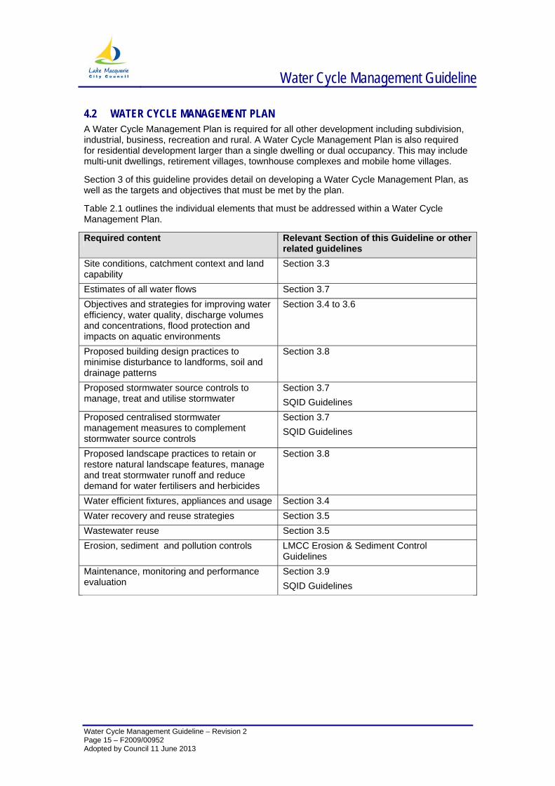
4.2 WATER CYCLE MANAGEMENT PLAN A Water Cycle Management Plan is required for all other development including subdivision, industrial, business, recreation and rural. A Water Cycle Management Plan is also required for residential development larger than a single dwelling or dual occupancy. This may include multi-unit dwellings, retirement villages, townhouse complexes and mobile home villages.
Section 3 of this guideline provides detail on developing a Water Cycle Management Plan, as well as the targets and objectives that must be met by the plan.
Table 2.1 outlines the individual elements that must be addressed within a Water Cycle Management Plan.
Required content Relevant Section of this Guideline or other related guidelines
Site conditions, catchment context and land capability
Section 3.3
Estimates of all water flows Section 3.7 Objectives and strategies for improving water efficiency, water quality, discharge volumes and concentrations, flood protection and impacts on aquatic environments
Section 3.4 to 3.6
Proposed building design practices to minimise disturbance to landforms, soil and drainage patterns
Section 3.8
Proposed stormwater source controls to manage, treat and utilise stormwater
Section 3.7 SQID Guidelines
Proposed centralised stormwater management measures to complement stormwater source controls
Section 3.7 SQID Guidelines
Proposed landscape practices to retain or restore natural landscape features, manage and treat stormwater runoff and reduce demand for water fertilisers and herbicides
Section 3.8
Water efficient fixtures, appliances and usage Section 3.4 Water recovery and reuse strategies Section 3.5 Wastewater reuse Section 3.5 Erosion, sediment and pollution controls LMCC Erosion & Sediment Control
Guidelines Maintenance, monitoring and performance evaluation
Section 3.9 SQID Guidelines
Water Cycle Management Guideline
Water Cycle Management Guideline – Revision 2 Page 16 – F2009/00952 Adopted by Council 11 June 2013
5 SECTION 3 – DEVELOPING A WATER CYCLE MANAGEMENT PLAN
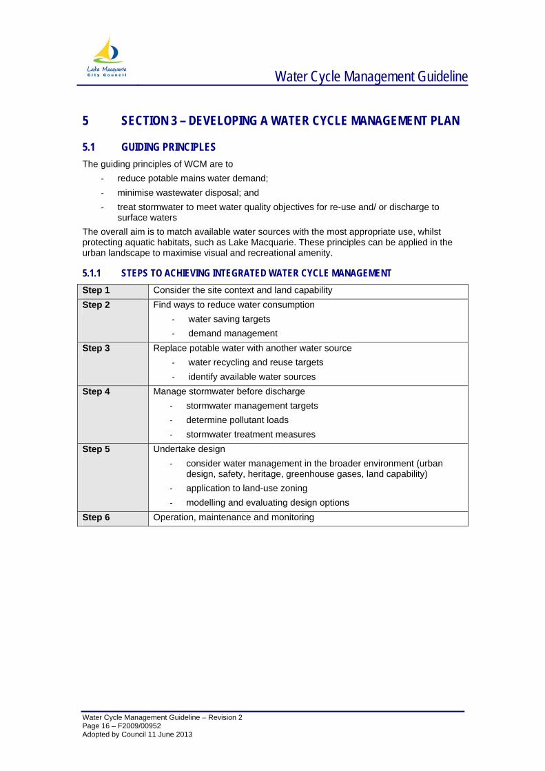
5.1 GUIDING PRINCIPLES The guiding principles of WCM are to
‐ reduce potable mains water demand; ‐ minimise wastewater disposal; and ‐ treat stormwater to meet water quality objectives for re-use and/ or discharge to
surface waters The overall aim is to match available water sources with the most appropriate use, whilst protecting aquatic habitats, such as Lake Macquarie. These principles can be applied in the urban landscape to maximise visual and recreational amenity.
5.1.1 STEPS TO ACHIEVING INTEGRATED WATER CYCLE MANAGEMENT Step 1 Consider the site context and land capability Step 2 Find ways to reduce water consumption
‐ water saving targets ‐ demand management
Step 3 Replace potable water with another water source ‐ water recycling and reuse targets ‐ identify available water sources
Step 4 Manage stormwater before discharge ‐ stormwater management targets ‐ determine pollutant loads ‐ stormwater treatment measures
Step 5 Undertake design ‐ consider water management in the broader environment (urban
design, safety, heritage, greenhouse gases, land capability) ‐ application to land-use zoning ‐ modelling and evaluating design options
Step 6 Operation, maintenance and monitoring
Water Cycle Management Guideline
Water Cycle Management Guideline – Revision 2 Page 17 – F2009/00952 Adopted by Council 11 June 2013
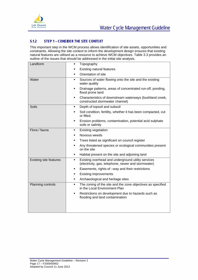
5.1.2 STEP 1 – CONSIDER THE SITE CONTEXT This important step in the WCM process allows identification of site assets, opportunities and constraints. Allowing the site context to inform the development design ensures that existing natural features are utilised as a resource to achieve WCM objectives. Table 3.3 provides an outline of the issues that should be addressed in the initial site analysis. Landform Topography
Existing natural features Orientation of site
Water Sources of water flowing onto the site and the existing water quality
Drainage patterns, areas of concentrated run-off, ponding, flood prone land
Characteristics of downstream waterways (bushland creek, constructed stormwater channel)
Soils Depth of topsoil and subsoil Soil condition, fertility, whether it has been compacted, cut
or filled. Erosion problems, contamination, potential acid sulphate
soils or salinity Flora / fauna Existing vegetation
Noxious weeds Trees listed as significant on council register Any threatened species or ecological communities present
on the site Habitat present on the site and adjoining land
Existing site features Existing overhead and underground utility services (electricity, gas, telephone, sewer and stormwater)
Easements, rights-of –way and their restrictions Existing improvements Archaeological and heritage sites
Planning controls The zoning of the site and the zone objectives as specified in the Local Environment Plan
Restrictions on development due to hazards such as flooding and land contamination
Water Cycle Management Guideline
Water Cycle Management Guideline – Revision 2 Page 18 – F2009/00952 Adopted by Council 11 June 2013
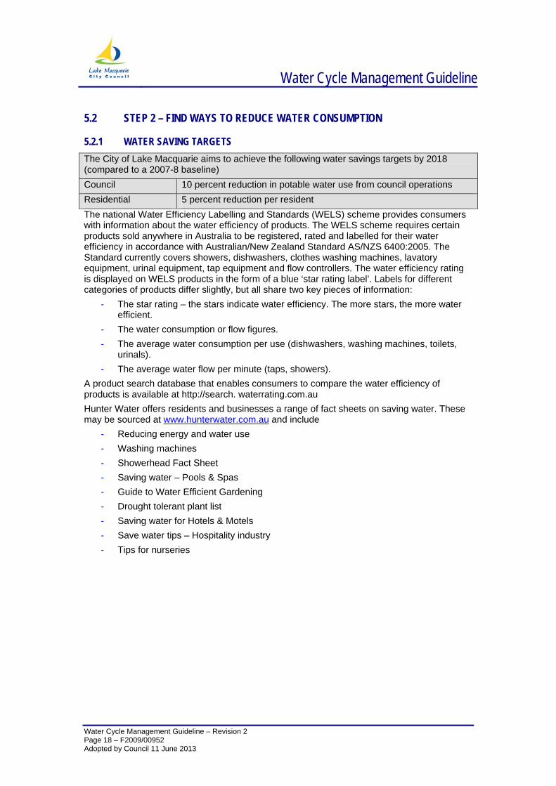
5.2 STEP 2 – FIND WAYS TO REDUCE WATER CONSUMPTION
5.2.1 WATER SAVING TARGETS The City of Lake Macquarie aims to achieve the following water savings targets by 2018 (compared to a 2007-8 baseline) Council 10 percent reduction in potable water use from council operations Residential 5 percent reduction per resident The national Water Efficiency Labelling and Standards (WELS) scheme provides consumers with information about the water efficiency of products. The WELS scheme requires certain products sold anywhere in Australia to be registered, rated and labelled for their water efficiency in accordance with Australian/New Zealand Standard AS/NZS 6400:2005. The Standard currently covers showers, dishwashers, clothes washing machines, lavatory equipment, urinal equipment, tap equipment and flow controllers. The water efficiency rating is displayed on WELS products in the form of a blue ‘star rating label’. Labels for different categories of products differ slightly, but all share two key pieces of information:
- The star rating – the stars indicate water efficiency. The more stars, the more water efficient.
- The water consumption or flow figures. - The average water consumption per use (dishwashers, washing machines, toilets,
urinals). - The average water flow per minute (taps, showers).
A product search database that enables consumers to compare the water efficiency of products is available at http://search. waterrating.com.au Hunter Water offers residents and businesses a range of fact sheets on saving water. These may be sourced at www.hunterwater.com.au and include
- Reducing energy and water use - Washing machines - Showerhead Fact Sheet - Saving water – Pools & Spas - Guide to Water Efficient Gardening - Drought tolerant plant list - Saving water for Hotels & Motels - Save water tips – Hospitality industry - Tips for nurseries
Water Cycle Management Guideline
Water Cycle Management Guideline – Revision 2 Page 19 – F2009/00952 Adopted by Council 11 June 2013
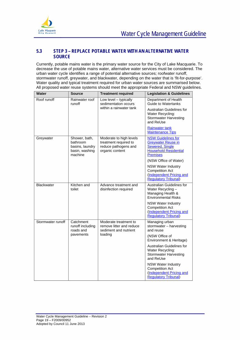
5.3 STEP 3 – REPLACE POTABLE WATER WITH AN ALTERNATIVE WATER SOURCE
Currently, potable mains water is the primary water source for the City of Lake Macquarie. To decrease the use of potable mains water, alternative water services must be considered. The urban water cycle identifies a range of potential alternative sources; roofwater runoff, stormwater runoff, greywater, and blackwater, depending on the water that is ‘fit-for-purpose’. Water quality and typical treatment required for urban water sources are summarised below. All proposed water reuse systems should meet the appropriate Federal and NSW guidelines. Water Source Treatment required Legislation & Guidelines Roof runoff Rainwater roof
runoff Low level – typically sedimentation occurs within a rainwater tank
Department of Health Guide to Watertanks Australian Guidelines for Water Recycling: Stormwater Harvesting and ReUse Rainwater tank Maintenance Tips
Greywater Shower, bath, bathroom basins, laundry basin, washing machine
Moderate to high levels treatment required to reduce pathogens and organic content
NSW Guidelines for Greywater Reuse in Sewered, Single Household Residential Premises (NSW Office of Water) NSW Water Industry Competition Act (Independent Pricing and Regulatory Tribunal)
Blackwater Kitchen and toilet
Advance treatment and disinfection required
Australian Guidelines for Water Recycling – Managing Health & Environmental Risks NSW Water Industry Competition Act (Independent Pricing and Regulatory Tribunal)
Stormwater runoff Catchment runoff including roads and pavements
Moderate treatment to remove litter and reduce sediment and nutrient loading
Managing urban stormwater – harvesting and reuse (NSW Office of Environment & Heritage) Australian Guidelines for Water Recycling: Stormwater Harvesting and ReUse NSW Water Industry Competition Act (Independent Pricing and Regulatory Tribunal)
Water Cycle Management Guideline
Water Cycle Management Guideline – Revision 2 Page 20 – F2009/00952 Adopted by Council 11 June 2013
5.4 STEP 4 – MANAGING STORMWATER BEFORE DISCHARGE INTO WATERWAYS
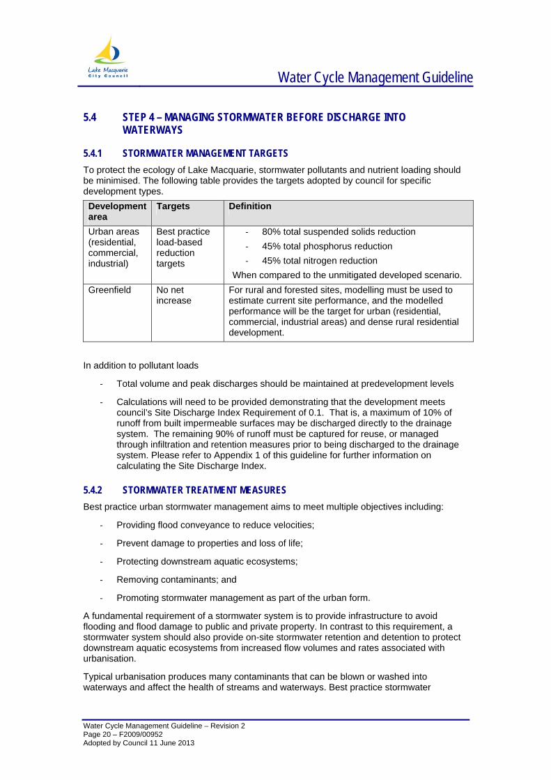
5.4.1 STORMWATER MANAGEMENT TARGETS To protect the ecology of Lake Macquarie, stormwater pollutants and nutrient loading should be minimised. The following table provides the targets adopted by council for specific development types. Development area
Targets Definition
Urban areas (residential, commercial, industrial)
Best practice load-based reduction targets
‐ 80% total suspended solids reduction ‐ 45% total phosphorus reduction ‐ 45% total nitrogen reduction
When compared to the unmitigated developed scenario. Greenfield No net
increase For rural and forested sites, modelling must be used to estimate current site performance, and the modelled performance will be the target for urban (residential, commercial, industrial areas) and dense rural residential development.
In addition to pollutant loads
‐ Total volume and peak discharges should be maintained at predevelopment levels
‐ Calculations will need to be provided demonstrating that the development meets council’s Site Discharge Index Requirement of 0.1. That is, a maximum of 10% of runoff from built impermeable surfaces may be discharged directly to the drainage system. The remaining 90% of runoff must be captured for reuse, or managed through infiltration and retention measures prior to being discharged to the drainage system. Please refer to Appendix 1 of this guideline for further information on calculating the Site Discharge Index.
5.4.2 STORMWATER TREATMENT MEASURES Best practice urban stormwater management aims to meet multiple objectives including:
‐ Providing flood conveyance to reduce velocities;
‐ Prevent damage to properties and loss of life;
‐ Protecting downstream aquatic ecosystems;
‐ Removing contaminants; and
‐ Promoting stormwater management as part of the urban form.
A fundamental requirement of a stormwater system is to provide infrastructure to avoid flooding and flood damage to public and private property. In contrast to this requirement, a stormwater system should also provide on-site stormwater retention and detention to protect downstream aquatic ecosystems from increased flow volumes and rates associated with urbanisation.
Typical urbanisation produces many contaminants that can be blown or washed into waterways and affect the health of streams and waterways. Best practice stormwater
Water Cycle Management Guideline
Water Cycle Management Guideline – Revision 2 Page 21 – F2009/00952 Adopted by Council 11 June 2013
management provides for treatment of runoff to remove water borne contaminants and provide protection to the environmental, social and economic value of receiving waterways.
Stormwater can carry a wide range of pollutant types and sizes, with no single treatment measure able to effectively treat all pollutants carried by stormwater. A combination of treatments, known as a treatment train, is therefore required to reduce the suite of pollutants contained in stormwater. The selection and order of treatments is a critical consideration in developing treatment trains. Essentially these treatment processes can be divided into five broad categories that target particular stormwater pollutant types including:
Screening – Coarse filtering of stormwater to separate the bulk of large organic debris, litter and some coarse sediment. Typically these are GPTs installed with screens, racks, baskets, nets etc to separate coarse matter from stormwater.
Filtration – Vegetation and media filtering to separate organic debris, litter and coarse to medium sediment.
Retention – Storage of stormwater for extended periods of time enabling pollutants including coarse to fine sediments and heavy metals to settle. These measures can also be configured to control flow rates and volumes during frequent storm events. Where the storage has no gravity outlet, stored stormwater can potentially be harvested for appropriate uses.
Biochemical - Biochemical treatment of stormwater to reduce dissolved pollutant loads through transformation to solid or gaseous forms. Fine sediment loads can also be removed through extended retention periods and interception on vegetation. Measures typically also function to control flow rates and volumes through retention and/or detention of stormwater.
Infiltration – Storages where the primary outlet for stormwater is infiltration into the surrounding soils. Typically these measures will have limited application except where insitu soils have high permeability and infiltration of stormwater would not result in additional seepage, excessive groundwater table rise, weakening of structural foundations or other implications for downslope properties.
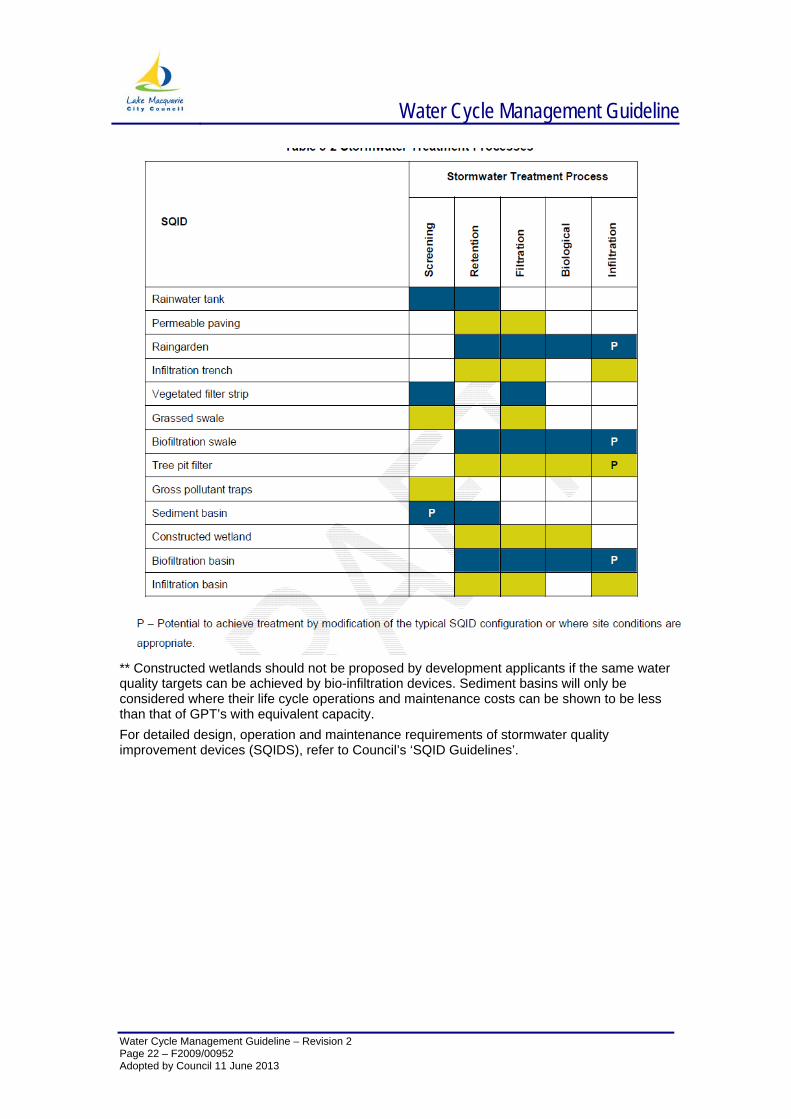
The treatment series should be configured to achieve the treatment processes in the order outlined above. Typically a development applicant should select a series of measures that will collectively perform all of these functions. Council’s preferred SQIDs and the relevant main stormwater treatment processes are summarised in Table 3-2. Table 3-2 outlines the ideal range of pollutants for optimal maintenance.
Water Cycle Management Guideline
Water Cycle Management Guideline – Revision 2
** Constructed wetlands should not be proposed by development applicants if the same water quality targets can be achieved by bio-infiltration devices. Sediment basins will only be considered where their life cycle operations and maintenance costs can be shown to be less than that of GPT’s with equivalent capacity. For detailed design, operation and maintenance requirements of stormwater quality improvement devices (SQIDS), refer to Council’s ‘SQID Guidelines’.
Page 22 – F2009/00952 Adopted by Council 11 June 2013
Water Cycle Management Guideline
Water Cycle Management Guideline – Revision 2 Page 23 – F2009/00952 Adopted by Council 11 June 2013
5.5 WATERCOURSE REHABILITATION Maintenance of healthy watercourses is assisted by the retention and management of healthy streamside (riparian) vegetation. Benefits of riparian vegetation extend not only to waterways themselves, but the landscape and amenity values of adjacent land. Please refer to section 2.1.1 of this document for required riparian buffer widths.
5.5.1 OBJECTIVES AND PRINCIPLES OF RIPARIAN REHABILITATION Always protect existing native vegetation
Protect the natural morphology of the watercourse
Use streamside vegetation to maximise local landscape and aesthetic values.
5.5.2 PROTECTING EXISTING VEGETATION & NEW PLANTINGS Protecting existing stands of riparian vegetation will often be the easiest and most cost-effective method of meeting vegetation objectives. The following provides key actions to maximise the retention of existing vegetation:
• Avoid removing vegetation wherever possible, particularly mature and sound stands.
• Avoid removing dead trees, either standing or fallen, unless they are a safety hazard, as they provide valuable habitat
• Integrate any new plantings with existing vegetation
• Limit access to riparian zones for protection of sensitive vegetation, promote regeneration and for public safety reasons
Revegetation may be necessary to replace previously cleared areas, or to ensure that riparian vegetation communities are relatively continuous. The following should be considered for new plantings:
• Always use indigenous plants – refer to the Lake Macquarie Streambank and Foreshore Planting Guide.
• Good weed control is essential to promote the survival and establishment of native vegetation. A well planned and funded maintenance regime for a minimum of two years is required .
• Use erosion control matting in conjunction with revegetation to enhance survival rates, as well as stabilising soils
• Always consider temporary fencing and tree guards to protect new plantings from vermin and human interaction.
5.5.3 PROTECT THE NATURAL MORPHOLOGY OF THE WATERCOURSE Through the impact of increased flows and removal of riparian vegetation, the bed and banks of waterways can become highly susceptible to erosion. This in turn may result in increased turbidity, smothering instream vegetation and ultimately increasing sediment loads in Lake Macquarie. Increased erosion also undermines remnant indigenous vegetation in adjoining parkland and threatens assets such as bridges and path systems. Soft engineering solutions are preferred to prevent further erosion and should be sympathetic to the watercourse environment.
Technical detail on soft engineering solutions may be found in Brisbane City Council’s “Natural Channel Design” Guidelines.
Water Cycle Management Guideline
Water Cycle Management Guideline – Revision 2 Page 24 – F2009/00952 Adopted by Council 11 June 2013
5.6 STEP 5 – UNDERTAKE WATER CYCLE MANAGEMENT DESIGN
5.6.1 MODELLING OF DESIGN OPTIONS Urban stormwater quality improvement systems in urban areas are predominantly driven by climatic factors – the occurrence of storm events or dry weather conditions. These are highly variable in terms of the seasonality of occurrences, their magnitude, and duration. The performance of an urban stormwater quality improvement strategy is not determined by an individual storm event, but is the aggregate of a continuous period of typical climatic conditions. Monitoring and water quality sampling of a small number of storm events are normally not sufficient to define system performance.
Performance assessment of stormwater treatment strategies will often be based on estimating mean annual pollutant loads exported from a catchment following development. Modelling using well established computer models of urban stormwater management systems is a recognised method for determining their long-term performance. Modelling will involve the use of historical or synthesized long-term rainfall data and algorithms that can simulate the performance of stormwater treatment measures to determine stormwater pollution control outcomes.
The Cooperative Research Centre for Catchment Hydrology (now eWater) has developed stormwater evaluation software named MUSIC (Model for Urban Stormwater Improvement Conceptualisation). The software serves as a planning and decision support system , and packages the most current knowledge of the performance of a range of stormwater treatment measures into an easily used tool. Importantly, MUSIC allows a first estimate on the expected pollutant load from catchments following development in the absence of any stormwater treatment initiatives. It can be then used to compare alternative treatment strategies from compliance to Council’s stormwater quality objectives. Whilst there are a range of other computer models available MUSIC appears to be the most widely used tool for modelling urban stormwater quality improvement systems. The preferred MUSIC parameters for use within the City of Lake Macquarie’s catchments are available on Council’s website.
5.6.2 CONSIDERING WATER CYCLE MANAGEMENT IN THE BROADER ENVIRONMENT In applying water cycle management principles to development, the goal is good design incorporating treatment elements. Planning needs to be considered at the initial phases of an urban development and can enhance the aesthetic, amenity and recreation opportunities of an area as well as protecting its environmental values.
Open Space Layout
Integration of open space with conservation corridors, stormwater management systems and recreational facilities is a fundamental objective of the WCM strategy. Open space areas can potentially incorporate stormwater conveyance and treatment systems as landscape features.
Road layouts and streetscaping
Roads account for a significant percentage of the overall impervious hard surfaces created within a typical urban development, and have a significant impact on the way water is transported through an area. These areas also generate water borne stormwater contaminants that can adversely impact on receiving waterway health. Consequently, it is important to mitigate the impact of stormwater runoff generated from road surfaces. By carefully planning road alignments and streetscapes, drainage elements such as bioretention systems and vegetated swales can be used to collect, attenuate, convey and treat the runoff before it is discharged to receiving waterways.
Opportunities exist for incorporating stormwater elements into roadways by diverting the flow from the road to a treatment system. This requires that traditional road features such as medians, traffic calming bays, street tree sand car parking nodes are designed to be lower
Water Cycle Management Guideline
Water Cycle Management Guideline – Revision 2 Page 25 – F2009/00952 Adopted by Council 11 June 2013
than the road level to collect run-off from the road. Other features such as kerb and gutter may be replaced with grass swales.
When implementing street tree planting, bioretention tree pits can be applied, and road runoff filtered through a specified soil media prior to discharge to the stormwater system. Traffic medians can be retrofitted to become raingarden / bioretention systems.
Lot Layouts
Water Sensitive Urban Design promotes the use of smaller more compact housing lots adjacent to open space that typically have high amenity value. This allows greater community access to open space as well as natural and landscaped features that form the local stormwater drainage system. Where practicable, natural landscape features such as remnant vegetation and natural waterways should be incorporated within open space, with housing lots configured around the open space. Views and access should also be considered in the design. The connectivity of the lots to the open space allows the creation of smaller lots, due to the need for less private lawn and garden area. Experience would suggest that lots with direct access to open space and water features have elevated values compared to conventional designs.
5.6.3 APPLICATION OF WCM TO DEVELOPMENT TYPE The six steps to water cycle management help developers apply a demand management and fit-for-purpose approach to water management. The following summaries show generally the WCM strategies that are useful for different development types.
5.6.4 SINGLE ALLOTMENT AND SMALL RESIDENTIAL SUBDIVISION This category describes the bulk of residential suburban houses, dual occupancy and small scale sub-divisions such as townhouses and attached dwellings. These developments typically comprise a single detached dwelling and associated buildings such as garages and sheds. These allotments will often include such features as driveways and front and rear yards. The size of the allotments may be typically between 500 to 1000 m2 but can be larger in rural residential areas. The impervious surfaces associated with single allotments include the roofs, driveways, paths, and other hard surfaces such as patios. Pervious areas of the site include any garden or lawn areas. A medium-sized lot may have a site imperviousness of 40 to 60%. The water used on single allotments comprises:
potable water requirements such as drinking and food preparation non-potable water requirements such as toilet flushing, clothes washing, hot water
systems, pools, and garden irrigation. Treatment type Opportunities Constraints Options
Water use reduction
Demand for non-potable water exceeds supply
Installation of water efficient appliances and fixtures
Water re-use Many non-potable water demands can be met using alternative water supplies such as treated wastewater, rainwater and/or groundwater
Space is often available for rainwater tanks
May be insufficient capacity to treat waste water to appropriate public health standards
Roof runoff may be collected in rainwater tanks and reused for internal uses such as toilets and washing machines Grey water from the laundry and bathroom may be used for garden irrigation.
Water Cycle Management Guideline
Water Cycle Management Guideline – Revision 2 Page 26 – F2009/00952 Adopted by Council 11 June 2013
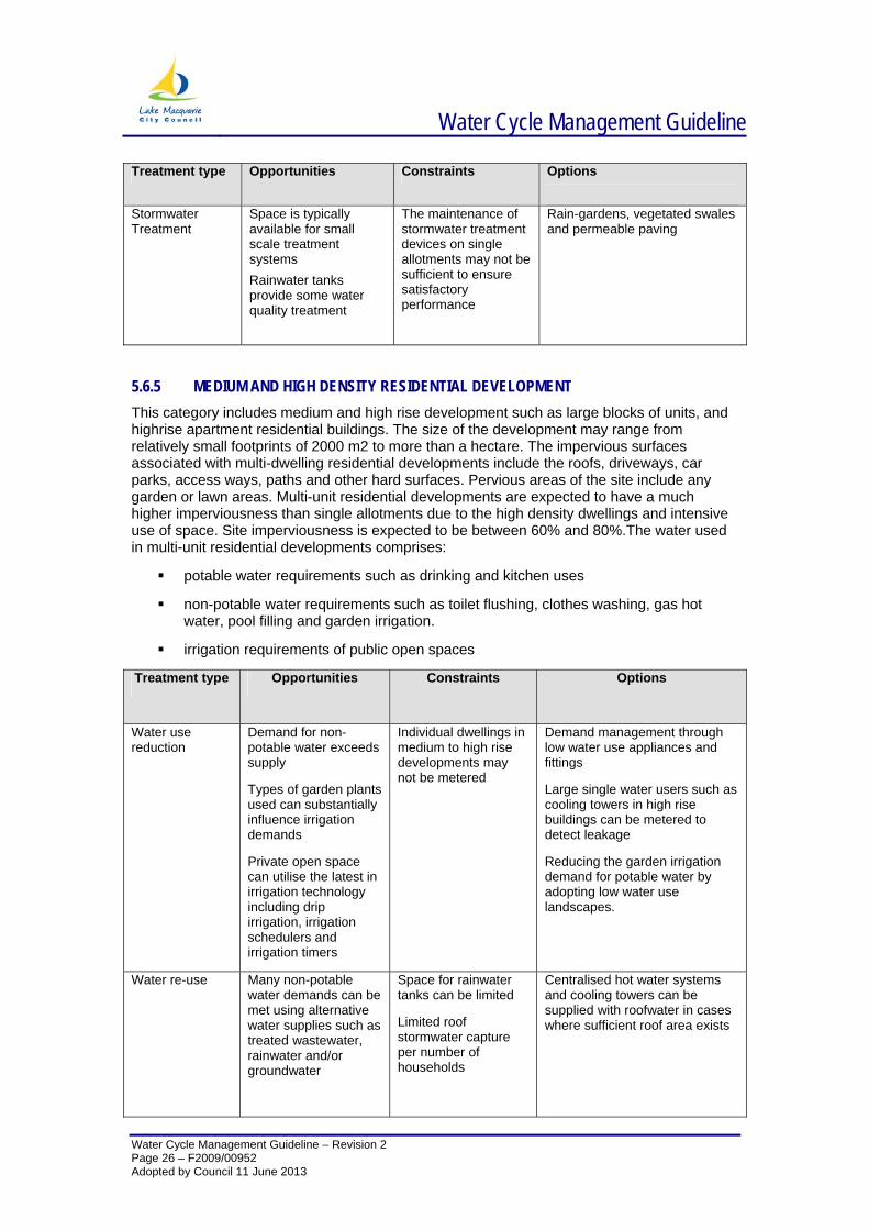
Treatment type Opportunities Constraints Options
Stormwater Treatment
Space is typically available for small scale treatment systems Rainwater tanks provide some water quality treatment
The maintenance of stormwater treatment devices on single allotments may not be sufficient to ensure satisfactory performance
Rain-gardens, vegetated swales and permeable paving
5.6.5 MEDIUM AND HIGH DENSITY RESIDENTIAL DEVELOPMENT This category includes medium and high rise development such as large blocks of units, and highrise apartment residential buildings. The size of the development may range from relatively small footprints of 2000 m2 to more than a hectare. The impervious surfaces associated with multi-dwelling residential developments include the roofs, driveways, car parks, access ways, paths and other hard surfaces. Pervious areas of the site include any garden or lawn areas. Multi-unit residential developments are expected to have a much higher imperviousness than single allotments due to the high density dwellings and intensive use of space. Site imperviousness is expected to be between 60% and 80%.The water used in multi-unit residential developments comprises:
potable water requirements such as drinking and kitchen uses
non-potable water requirements such as toilet flushing, clothes washing, gas hot water, pool filling and garden irrigation.
irrigation requirements of public open spaces
Treatment type Opportunities Constraints Options
Water use reduction
Demand for non-potable water exceeds supply
Types of garden plants used can substantially influence irrigation demands
Private open space can utilise the latest in irrigation technology including drip irrigation, irrigation schedulers and irrigation timers
Individual dwellings in medium to high rise developments may not be metered
Demand management through low water use appliances and fittings
Large single water users such as cooling towers in high rise buildings can be metered to detect leakage
Reducing the garden irrigation demand for potable water by adopting low water use landscapes.
Water re-use Many non-potable water demands can be met using alternative water supplies such as treated wastewater, rainwater and/or groundwater
Space for rainwater tanks can be limited
Limited roof stormwater capture per number of households
Centralised hot water systems and cooling towers can be supplied with roofwater in cases where sufficient roof area exists
Water Cycle Management Guideline
Water Cycle Management Guideline – Revision 2 Page 27 – F2009/00952 Adopted by Council 11 June 2013
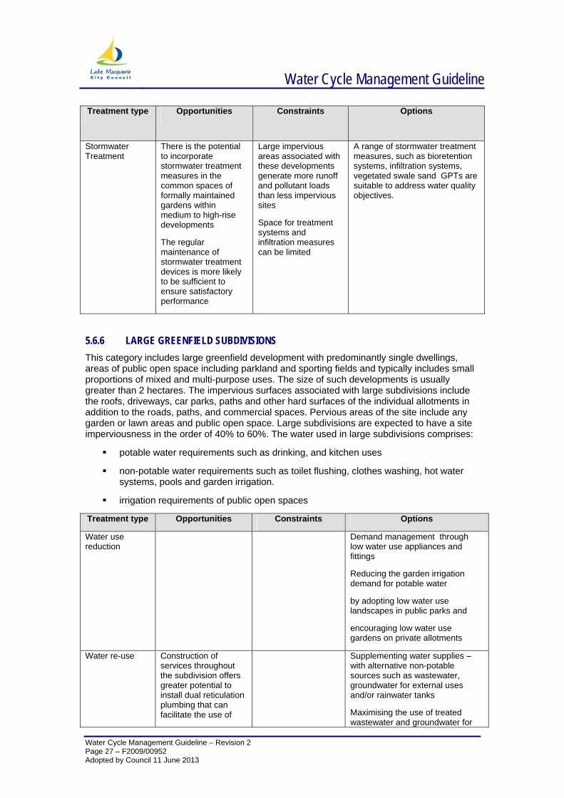
Treatment type Opportunities Constraints Options
Stormwater Treatment
There is the potential to incorporate stormwater treatment measures in the common spaces of formally maintained gardens within medium to high-rise developments
The regular maintenance of stormwater treatment devices is more likely to be sufficient to ensure satisfactory performance
Large impervious areas associated with these developments generate more runoff and pollutant loads than less impervious sites
Space for treatment systems and infiltration measures can be limited
A range of stormwater treatment measures, such as bioretention systems, infiltration systems, vegetated swale sand GPTs are suitable to address water quality objectives.
5.6.6 LARGE GREENFIELD SUBDIVISIONS This category includes large greenfield development with predominantly single dwellings, areas of public open space including parkland and sporting fields and typically includes small proportions of mixed and multi-purpose uses. The size of such developments is usually greater than 2 hectares. The impervious surfaces associated with large subdivisions include the roofs, driveways, car parks, paths and other hard surfaces of the individual allotments in addition to the roads, paths, and commercial spaces. Pervious areas of the site include any garden or lawn areas and public open space. Large subdivisions are expected to have a site imperviousness in the order of 40% to 60%. The water used in large subdivisions comprises:
potable water requirements such as drinking, and kitchen uses
non-potable water requirements such as toilet flushing, clothes washing, hot water systems, pools and garden irrigation.
irrigation requirements of public open spaces
Treatment type Opportunities Constraints Options
Water use reduction
Demand management through low water use appliances and fittings
Reducing the garden irrigation demand for potable water
by adopting low water use landscapes in public parks and
encouraging low water use gardens on private allotments
Water re-use Construction of services throughout the subdivision offers greater potential to install dual reticulation plumbing that can facilitate the use of
Supplementing water supplies – with alternative non-potable sources such as wastewater, groundwater for external uses and/or rainwater tanks
Maximising the use of treated wastewater and groundwater for
Water Cycle Management Guideline
Water Cycle Management Guideline – Revision 2 Page 28 – F2009/00952 Adopted by Council 11 June 2013
Treatment type Opportunities Constraints Options
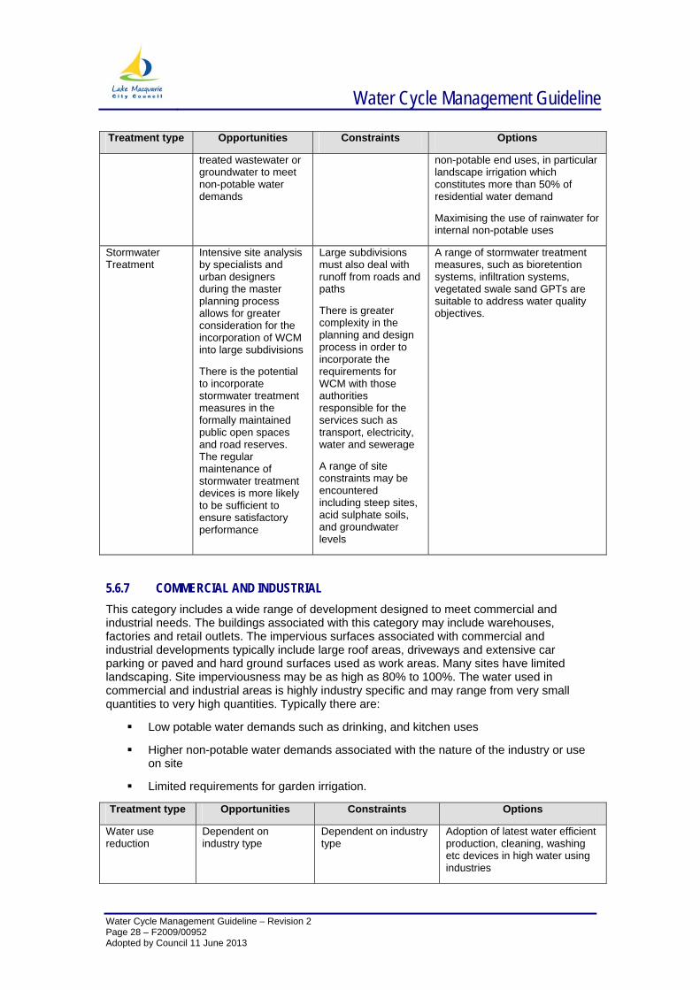
treated wastewater or groundwater to meet non-potable water demands
non-potable end uses, in particular landscape irrigation which constitutes more than 50% of residential water demand
Maximising the use of rainwater for internal non-potable uses
Stormwater Treatment
Intensive site analysis by specialists and urban designers during the master planning process allows for greater consideration for the incorporation of WCM into large subdivisions
There is the potential to incorporate stormwater treatment measures in the formally maintained public open spaces and road reserves. The regular maintenance of stormwater treatment devices is more likely to be sufficient to ensure satisfactory performance
Large subdivisions must also deal with runoff from roads and paths
There is greater complexity in the planning and design process in order to incorporate the requirements for WCM with those authorities responsible for the services such as transport, electricity, water and sewerage
A range of site constraints may be encountered including steep sites, acid sulphate soils, and groundwater levels
A range of stormwater treatment measures, such as bioretention systems, infiltration systems, vegetated swale sand GPTs are suitable to address water quality objectives.
5.6.7 COMMERCIAL AND INDUSTRIAL This category includes a wide range of development designed to meet commercial and industrial needs. The buildings associated with this category may include warehouses, factories and retail outlets. The impervious surfaces associated with commercial and industrial developments typically include large roof areas, driveways and extensive car parking or paved and hard ground surfaces used as work areas. Many sites have limited landscaping. Site imperviousness may be as high as 80% to 100%. The water used in commercial and industrial areas is highly industry specific and may range from very small quantities to very high quantities. Typically there are:
Low potable water demands such as drinking, and kitchen uses
Higher non-potable water demands associated with the nature of the industry or use on site
Limited requirements for garden irrigation.
Treatment type Opportunities Constraints Options
Water use reduction
Dependent on industry type
Dependent on industry type
Adoption of latest water efficient production, cleaning, washing etc devices in high water using industries
Water Cycle Management Guideline
Water Cycle Management Guideline – Revision 2 Page 29 – F2009/00952 Adopted by Council 11 June 2013
Treatment type Opportunities Constraints Options
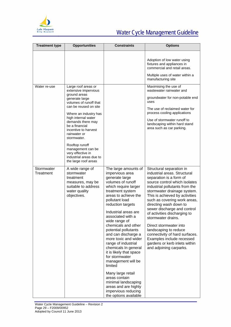
Adoption of low water using fixtures and appliances in commercial and retail areas.
Multiple uses of water within a manufacturing site
Water re-use Large roof areas or extensive impervious ground areas generate large volumes of runoff that can be reused on site
Where an industry has high internal water demands there may be a financial incentive to harvest rainwater or stormwater.
Rooftop runoff management can be very effective in industrial areas due to the large roof areas
Maximising the use of wastewater rainwater and
groundwater for non-potable end uses
The use of reclaimed water for process cooling applications
Use of stormwater runoff to landscaping within hard stand area such as car parking.
Stormwater Treatment
A wide range of stormwater treatment measures, may be suitable to address water quality objectives.
The large amounts of impervious area generate large volumes of runoff which require larger treatment system areas to achieve the pollutant load reduction targets
Industrial areas are associated with a wide range of chemicals and other potential pollutants and can discharge a more toxic and wider range of industrial chemicals In general it is likely that space for stormwater management will be limited
Many large retail areas contain minimal landscaping areas and are highly impervious reducing the options available
Structural separation in industrial areas. Structural separation is a form of source control which isolates industrial pollutants from the stormwater drainage system. This is achieved by activities such as covering work areas, directing wash down to sewer discharge and control of activities discharging to stormwater drains.
Direct stormwater into landscaping to reduce connectivity of hard surfaces. Examples include recessed gardens or kerb inlets within and adjoining carparks.
Water Cycle Management Guideline
Water Cycle Management Guideline – Revision 2 Page 30 – F2009/00952 Adopted by Council 11 June 2013
Treatment type Opportunities Constraints Options
for effective treatment of stormwater runoff
5.6.8 INFRASTRUCTURE Transport infrastructure, particularly roads, are the principal type of infrastructure that requires consideration in WCM. Transport infrastructure includes parking areas for vehicles. In many urban areas, stormwater runoff from roads and other transport infrastructure contains a high proportion of the pollutants. Roads form extensive parts of the landscape and thus influence the quality of stormwater in many areas. Where roads are used frequently this can lead to a build-up of many pollutant particles on the road surfaces i.e. brake dust, fuels and oils, rubber, dust soil, debris and litter. The imperviousness associated with the transport corridors and road reserves depends on the proportion of area dedicated to bitumen or concrete. Site imperviousness typically range from 50% to 100% of the road reserve.
Treatment type Opportunities Constraints Options
Water re-use Road surfaces generate large volumes of runoff
Passive irrigation for landscaping
Stormwater Treatment
A variety of stormwater treatment devices are available and can be configured to accommodate the road runoff drainage network
Space available for stormwater treatment
Treatment of road runoff removes a significant source of oil and grease, heavy metals and other toxic pollutants from urban stormwater runoff
Many services are associated with transport corridors and road reserves (i.e. electricity, gas, sewer, water) and these can restrict the space available for stormwater treatment
Road networks are extensive and it is not practical to treat all road runoff, therefore specific locations should be targeted
Road surfaces generate large volumes of runoff
Strict controls regarding flooding, safety, facilities and access requirements
Pre-treatment of road runoff using gross pollutant and coarse sediment removal techniques such as gross pollutant traps, and road side swales
Infiltration systems may be used in some areas with appropriate pre-treatment of stormwater and a suitable buffer from infrastructure to protect road pavement.
Stormwater treatment measures appropriate for transport infrastructure include swales, bioretention systems and basins to address water quality and objectives.
Stormwater run-off from key pollutant generating areas should be subjected to stormwater treatment
Future opportunities for the detention, treatment and infiltration of road runoff should be investigated for key pollutant generating areas

Water Cycle Management Guideline
Water Cycle Management Guideline – Revision 2 Page 31 – F2009/00952 Adopted by Council 11 June 2013
5.6.9 OPERATION & MAINTENANCE For information regarding the operation and maintenance of SQIDS, please refer to Section 6 of Council’s SQID Guidelines.
For information regarding the operation and maintenance of rainwater tanks, please refer to Council’s website.
Water Cycle Management Guideline
Water Cycle Management Guideline – Revision 2 Page 32 – F2009/00952 Adopted by Council 11 June 2013
6 APPENDICES
6.1 APPENDIX 1 - CALCULATING THE SITE DISCHARGE INDEX What is the site discharge index?
Site discharge index is a numerical value that relates the total area of a development site with the area of impermeable surface that drains directly to a drainage system.
In order to satisfy the criteria, designers need to incorporate sufficient measures to manage stormwater runoff from impermeable surfaces within the development site.
Why are impermeable surfaces important?
Impermeable surfaces are hard surfaces through which rainwater cannot infiltrate to the underlying soil. Examples of impermeable surfaces include roofs, driveways and paving. All rainwater falling on these surfaces produces runoff. In conventional stormwater systems, runoff from impermeable surfaces is collected by simple drains and conveyed directly to the street drainage system. In contrast, WCM seeks to reduce the direct flow of runoff from impermeable surfaces.
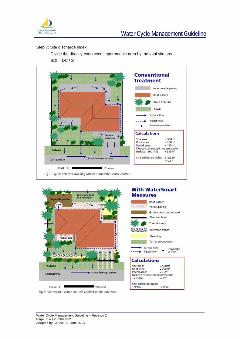
What does the site discharge index measure?
Site discharge index provides a very general indicator of the extent to which a development proposal will create unmanaged flows from impermeable surfacesThe greater the area of impermeable surface that is not managed by stormwater source controls the higher the site discharge index will be (up to a maximum of 1.0 on a site that is totally covered by impermeable surfaces). Using conventional drainage, typical low and medium density development will score a site discharge index of approximately 0.4-0.6. However, by incorporating appropriate measures a site discharge index of 0.0 -0.1 can readily be achieved. Under the Lake Macquarie City Council Development Control Plan, development proposals need to satisfy a site discharge index of 0.1.
How is site discharge index calculated?
The site discharge index for a development proposal can be readily calculated using the information contained in ordinary building and site plans.
Step 1: Site Area – calculate the total site area (S) Step 2: Roof Area – calculate the total roofed area (R) Step 3: Paved area – calculate the total paved area (P) Step 4: Calculate the total impermeable area (I)
I = R + P Step 5: Manage impermeable area.
Identify runoff paths from each impermeable surface. Identify each component that is managed by an acceptable stormwater source control. That is, the runoff must pass through a source control prior to discharge to the street drainage system. Calculate the total area of impermeable surface that is managed by acceptable stormwater source controls (M)
Step 6: Directly-connected impermeable area Calculate the area of impermeable surface that discharges directly to the street drainage system or interallotment easement without passing through an acceptable stormwater source control (DC). DC = I-M
Water Cycle Management Guideline
Water Cycle Management Guideline – Revision 2
Step 7: Site discharge index Divide the directly-connected impermeable area by the total site area. SDI = DC / S
Page 33 – F2009/00952 Adopted by Council 11 June 2013
Water Cycle Management Guideline
Water Cycle Management Guideline – Revision 2 Page 34 – F2009/00952 Adopted by Council 11 June 2013
6.2 APPENDIX 2 – USING MITIGATION DEPTH TO CALCULATE STORAGE REQUIREMENTS
Whilst the SDI can be used to determine the area of impervious surfaces that must be managed by stormwater harvesting (the ‘managed impermeable area’), it cannot determine how much capacity those controls should have.
By providing temporary storage of runoff from impermeable surfaces, stormwater harvesting can be used to mimic the natural (pre-development) balance between runoff and infiltration. Storage capacity needs to be sufficient to accommodate increased runoff from permeable surfaces to ensure the level of runoff from impermeable surfaces does not exceed the level of runoff equivalent of that once permeable (natural) surface during a rainfall event with an Average Recurrence Interval (ARI) of 3 months or less.
The amount of storage required to mimic natural conditions varies with soil type. More storage is required on sandy soils (as a high proportion of rainfall naturally infiltrates to the soil), whereas less storage is required on heavy clay soils (as rainfall largely runs off to nearby streams).
Calculating storage requirements using mitigation depth
The storage requirement for a harvesting measure must be calculated separately, based on the actual area of impermeable surfaces that drain to a harvesting measure.. This will ensure that impervious surfaces on the site are adequately managed.
The amount of stormwater runoff that must be captured to mimic natural permeability during a 3 month ARI rainfall event is termed the Mitigation Depth (MD). It is expressed in millimetres and is equivalent to the number of litres of storage capacity that must be provided for each square of impermeable surface that drains to a stormwater harvesting measure.
Mitigation depth varies from site to site according to the rainfall characteristics and soil texture. The calculation can be broken down into the following steps.
Step 1: Soil texture
Determine the relevant soil texture class for the site (sand, sandy loam, clay loam or clay). This can be determined by a simple soil test.
Step 2: Mitigation depth
Using the information from Step 1 read off the required Mitigation Depth (MD) for the site from the table below.
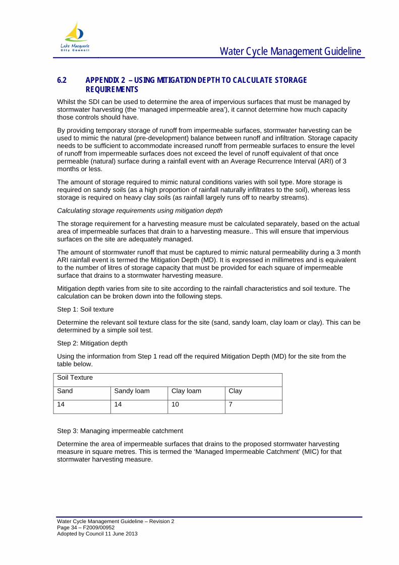
Soil Texture
Sand Sandy loam Clay loam Clay
14 14 10 7
Step 3: Managing impermeable catchment
Determine the area of impermeable surfaces that drains to the proposed stormwater harvesting measure in square metres. This is termed the ‘Managed Impermeable Catchment’ (MIC) for that stormwater harvesting measure.
Water Cycle Management Guideline
Water Cycle Management Guideline – Revision 2 Page 35 – F2009/00952 Adopted by Council 11 June 2013
Step 4: Mitigation storage
Using the information from Steps 2 and 3 calculate the mitigation storage for the stormwater harvesting measure using the following formula:
MS = MIC x MD / 1000
Where:
MS = mitigation storage (kilolitres)
MIC = managed impermeable catchment (m2)
MD = mitigation depth (mm)