washington county, oregon countywide windshield …
TRANSCRIPT

Washington County Windshield Procedures 1
WASHINGTON COUNTY, OREGON COUNTYWIDE WINDSHIELD SURVEY PROCEDURES
July 2016
I. PURPOSE
The purpose of the Washington County Windshield Survey procedures is to
define the operational concepts, organizational assignments, responsibilities,
and procedures for the rapid assessment and reporting of damages to critical
facilities and the associated human impacts (i.e., injury and loss of life) following
an earthquake.
II. OBJECTIVES
The objectives of the Washington County windshield survey process are to:
A. Identify the extent and magnitude of incident impact for overall
situational awareness.
B. Rapidly and very broadly assess damage to critical facilities and
associated human impacts to inform incident prioritization and resource
management.
C. Ensure timely and deliberate sharing of assessment information to help
establish a common operating picture and inform initial policy, support,
and coordination actions.
III. RELATIONSHIP TO OTHER PLANS
A. These procedures are the windshield survey tab to the Damage
Assessment Annex of the Washington County Emergency Operations Plan.
B. These procedures provide guidelines for county department, city, and
special district windshield survey procedures.
C. Assessment information developed pursuant to implementation of these
procedures informs other county and agency damage assessment
processes including building safety inspections, the countywide Initial

Washington County Windshield Procedures 2
Damage Assessment (IDA), the Community Assessment for Public Health
Emergency Response (CASPER), and the Red Cross Community Damage
Assessment.
D. These procedures work in conjunction with, but do not replace or
supersede, the Emergency Transportation Route damage assessment
procedures implemented by the Oregon Department of Transportation,
the Washington County Department of Land Use and Transportation,
neighboring counties, and the Portland Bureau of Transportation.
IV. DEFINITIONS
A. Critical Facility – Facilities that are critical to government response
activities as well as those that pose a substantial risk to life safety. For
purposes of these procedures, the following specific facilities and
categories of facilities are considered critical:
1. The Washington County Consolidated Communications Agency
(i.e., the county 911 center)
2. Emergency Operations Centers (EOCs) and Department Operations
Centers (DOCs)
3. Law enforcement facilities (command and control and
maintenance)
4. Fire and emergency medical service facilities (command and
control and maintenance)
5. Public works facilities (command and control and maintenance)
6. Sewage treatment facilities
7. Water treatment facilities
8. Scoggins Dam and Eldon Mills Dam
9. Hospitals
10. Emergency Transportation Routes (ETRs), other specifically identified
critical arterials and collectors, and bridges and overpasses on
those routes
11. Emergency fueling facilities identified by Washington County
pursuant to the Oregon Fuel Action Plan
12. The Hillsboro Airport
13. National Guard armories
14. The Washington County Jail and the Coffee Creek Correctional
Facility
15. K-12 public and private schools (when occupied)
16. Phone switching centers and central offices (landline and cellular)
17. Electrical system bulk power substations, operating centers
performing dispatch functions, and maintenance/resource centers
18. Natural gas system maintenance/resource centers
19. The Comcast network head end, hubs, and dispatch center

Washington County Windshield Procedures 3
20. Specifically identified hazardous material facilities which, if
damaged, could cause serious human impact
21. Long-term care facilities (including skilled nursing and assisted living
facilities and residential care facilities (including independent living
centers)
B. Modified Mercalli Intensity (MMI) Scale – A seismic scale used for
measuring the intensity of an earthquake. It measures the effects of an
earthquake, and is distinct from the moment magnitude (Mw) usually
reported for an earthquake, which is a measure of the energy released.
The MMI scale quantifies the effects of an earthquake on the Earth's
surface, humans, objects of nature, and man-made structures on a scale
from I (not felt) to XII (total destruction). (See Appendix A for a description
of the MMI Scale.)
C. Windshield Survey – The rapid visual survey of a facility or structure typically
completed from inside a vehicle with the goal of noting and recording
obvious physical and human impacts at or immediately adjacent to the
facility or structure.
V. SITUATION AND ASSUMPTIONS
A. Situation
As identified in the Washington County Hazard Analysis, there is just one
hazardous event threatening the county that occurs spontaneously and
has the potential for causing widespread deaths, injuries, and property
damage. That event is an earthquake. All other hazardous events are
slow-building or impact a more narrow area.
The rapid assessment of damages and human impact and the sharing of
that information immediately following a widespread major incident are
critical to establishing situational awareness at the local level and a
common operating picture at the countywide level and are necessary for
informed incident prioritization and resource allocation decisions.
The County Emergency Operations Center (EOC) and other agency EOCs
and Department Operations Centers (DOCs) will not likely be activated at
the time the windshield survey process is initiated. Exceptions would be if
the EOCs and DOCs were already activated for another event or if an
aftershock of significant magnitude occurred when the EOCs and DOCs
had already been activated for an initial earthquake.
Critical facilities covered by this plan have been identified, classified and
sorted by type (e.g., fire, law enforcement, public works, utilities, etc.),

Washington County Windshield Procedures 4
mapped, and cataloged and each has been assigned a unique facility
identifier. The identified facilities have been grouped geographically into
sectors and each sector has been given a distinct name and assigned to
a specific agency for survey. Those agencies have developed
procedures to ensure the facilities are surveyed in an expedient manner.
A master list of all facilities and sectors is maintained by the Washington
County Emergency Management Office. (See Appendices B, C, and D
for a list of facilities, community and sector codes, and survey
assignments, and for facility and sector maps.)
Critical facilities have been grouped into sectors with a goal of allowing
sector completion within two hours of the time the survey process is
initiated.
In some cases, a single building or site houses several critical facilities. For
example, the county’s Walnut Street Center includes a public works
maintenance facility, a fleet maintenance facility, and a Department
Operations Center (DOC). For purposes of these procedures, an order of
precedence has been established and the facility of highest precedence
is the only one mapped. The order of precedence for these situations is:
1. Fire and Emergency Medical Services Facilities
2. Hospitals
3. Public Works Facilities
4. Law Enforcement Facilities
5. Other Government Facilities (e.g., Emergency Operations Center)
6. Utility Facilities
7. Schools
8. Managed Care Facilities
9. Fuel Facilities
10. HazMat Facilities
Washington County windshield surveys are performed by public safety
and public works agencies and reported as identified in these
procedures. Agency EOCs/DOCs need not be activated to carry out the
procedures.
Agencies with assigned survey responsibilities may add other facilities to
their survey procedures if they deem them critical to local response efforts.
However, such facilities are not part of the countywide critical facility
catalog and are not included in the countywide reporting process.
Communication system outages, transportation disruptions, the need to
stop and render aid, and/or other circumstances will delay survey
completion and reporting.

Washington County Windshield Procedures 5
Not all agencies with assigned survey responsibilities have personnel on
duty 24X7. This will delay completion of their surveys.
Off-duty personnel may not be able to report for hours or even days after
the initial impact due to degraded transportation systems, disrupted
communications, and family concerns. This will delay the completion and
reporting of some windshield surveys.
Until the windshield survey process is completed, incident prioritization and
resource allocation is based on best available information.
If centralized communications are lost, agencies must act independently
to complete their surveys and assign their resources accordingly.
B. Assumptions
Sufficient personnel, equipment and facilities will be available to allow
completion of the windshield survey process, although initially available
resources may be limited.
All primary communications systems (trunked and repeated radio,
landline, cell phone, and Internet) may be inoperative; backup systems
(e.g., satellite telephones, simplex radio, and amateur radio) may be
operational but offer limited capability. Despite communications
outages, survey reports can still be made and the results shared through
available communications systems or in person.
Transportation systems may be severely disrupted and pre-identified
survey routes may be impassable, but windshield survey personnel will still
be able to complete their assessments.
VI. PROCEDURES
A. The windshield survey process consists of vehicle-based assessments of
critical facilities located across the county. Departments and agencies
with assigned survey responsibilities conduct windshield surveys and report
survey findings in accordance with these procedures.
B. The windshield survey process is implemented whenever an earthquake
(initial or aftershock) of MMI V – VII or greater impacts Washington County.
The process should also be activated whenever an earthquake,
regardless of intensity, causes a loss of telephone or primary public safety
communications systems or results in local damage that is reported
through the media or over public safety communications systems. While

Washington County Windshield Procedures 6
this threshold is subjective and the intensity of ground shaking and impact
may vary widely across the county, the intent is that the procedures be
activated whenever damage to critical facilities is known or likely to have
occurred.
C. The first agency to activate and begin the windshield survey process
notifies WCCCA. WCCCA then informs all on-duty fire, law enforcement,
and EMS personnel as well as the Washington County Emergency
Management staff (or Washington County EOC, if activated) that the
windshield survey procedures have been implemented. Severe
communications degradation (i.e., Disaster Operations) may delay or
eliminate notification through WCCCA.
D. Once the windshield survey process has been initiated, each department
and agency with windshield survey responsibilities implements their
respective survey procedures and assesses their assigned facilities. The
surveyors or survey teams record the facility assessment information on a
standard survey form (Appendix E). Other significant impacts observed
during the survey process are also recorded on the form. Whenever
possible, surveyors photograph damages and append the pictures to their
survey reports. If operational communications allow, survey teams can
transmit their findings to their parent agencies on a facility-by-facility basis.
E. Upon completing their assigned sectors, the surveyors or survey teams
report sector completion and assessment findings to their parent
department/agency. Each department/agency then compiles the
information into a single agency/ department report and forwards it to the
Washington County Emergency Management staff (or Washington County
EOC, if activated) and to its public safety and other key response partners.
The Sector Report Form (Appendix F) is used for department/agency
reporting. In lieu of reporting on the Sector Report Form, agencies
/departments can report survey results in WebEOC, the county’s crisis
management software program. The Washington County Emergency
Management staff (or Washington County EOC, if activated) compiles a
countywide report and shares it with all local governments, WCCCA,
hospitals, large utility providers, Metro West Ambulance, the state Office of
Emergency Management, and others as appropriate.
F. Department/Agency reports include completion of assigned sectors,
facility damage and human impact, and other significant impacts
observed during the survey process. Sectors are reported by sector name.
Damage and human impact are reported “by exception” (i.e., only
facilities with damage and/or human impact are reported) and linked to
the unique facility identifier. The countywide report includes critical facility
damages and human impacts and other significant impacts observed

Washington County Windshield Procedures 7
during the survey process.
G. All life safety incidents observed during the survey process are reported to
WCCCA by whatever means is possible.
VII. ORGANIZATION AND ASSIGNMENT OF RESPONSIBILITIES
A. General
The countywide windshield survey procedures are one element of a
comprehensive damage assessment process designed to determine the
extent, severity, and financial impacts of the event. The windshield
surveys are the first component to be implemented but are typically only
utilized following an instantaneous event with actual or potential
widespread impacts on the community (i.e., an earthquake). The surveys
are intended to provide a quick snapshot on the condition of critical
infrastructure throughout the county, assist with development of a
common operating picture, and guide initial incident prioritization and
resource allocation activities.
B. Task Assignments
1. Washington County Emergency Management (or the Washington
County EOC, if activated)
a. Assists WCCCA, if necessary, in notifying agencies of
procedure activation;
b. Coordinates the countywide survey process once activated;
c. Collects and consolidates agency survey reports; and
d. Distributes countywide survey reports to Washington County
public safety agencies and other agencies and organizations
with a need for the information.
2. The Washington County Consolidated Communications Agency
(WCCCA) notifies on-duty fire, law enforcement, and EMS personnel
as well as the Washington County Emergency Management staff (or
the Washington County EOC, if activated) when the windshield
survey procedures have been implemented.
3. Departments/Agencies with survey responsibilities, which includes
Washington County, the cities of Banks, Forest Grove, Cornelius,
North Plains, Hillsboro, Beaverton, Tigard, Tualatin, and Sherwood;
Tualatin Valley Fire and Rescue; Banks Fire District #13; Gaston Rural
Fire District; and the Joint Water Commission, conduct post-
earthquake windshield surveys and report survey findings to

Washington County Windshield Procedures 8
Washington County Emergency Management (or the Washington
County EOC, if activated) consistent with these procedures.
VIII. DIRECTION AND CONTROL
Once the windshield survey process is activated, each agency and department
with survey responsibilities is responsible for managing its own survey process,
directing its survey resources, and reporting survey results.
The Washington County Emergency Management staff (or the Washington
County EOC, if activated) is responsible for coordinating the countywide survey
process.
IX. ADMINISTRATION AND SUPPORT
A. Records and Reports
1. Departments/Agencies with survey responsibilities will:
a. Report survey findings to Washington County Emergency
Management (or the Washington County EOC, if activated)
consistent with these procedures.
b. Maintain a record of any survey conducted pursuant to these
procedures consistent with department/agency records
retention policies.
2. Washington County Emergency Management (or the Washington
County EOC, if activated) will compile countywide survey reports
and distribute them to Washington County public safety agencies
and other agencies and organizations with a need for the
information.
3. Washington County Emergency Management will maintain a
record of the countywide survey reports compiled pursuant to these
procedures consistent with the county’s records retention policies.
B. Release of Windshield Survey Information
Windshield survey reports and photographs should be released consistent
with the Oregon Public Records Law, the Health Insurance Portability and
Accountability Act (HIPPA), and department/agency procedures for the
release of information.

Washington County Windshield Procedures 9
X. ANNEX DEVELOPMENT AND MAINTENANCE
The Washington County Emergency Management office maintains these
procedures in cooperation with representatives of the departments and
agencies identified in Section VII (Organization and Assignment of
Responsibilities) and Appendix D (Community Codes, Sectors, and Assignments).
Each cooperating department and agency develops and maintains its own
survey implementation procedures.
The critical facility lists incorporated into these procedures will be reviewed
annually and appropriate changes made to both the lists and sector maps.
These procedures will be reviewed every two years in conjunction with review of
the Damage Assessment Annex to the Washington County Emergency
Operations Plan (EOP). They will also be reviewed following their use in an
exercise or actual event.
APPENDICES:
Appendix A Modified Mercalli Intensity Scale
Appendix B Critical Facility List – Published separately
Appendix C Community Codes, Sectors, and Agency Assignments
Appendix D Critical Facility Maps – Published Separately
Appendix E Windshield Survey Form
Appendix F Sector Report Form

Washington County Windshield Survey Procedures A-1
Appendix A
WASHINGTON COUNTY
WINDSHIELD SURVEY PROCEDURES
Modified Mercalli Intensity Scale
I. Not felt except by a very few under especially favorable conditions.
II. Felt only by a few persons at rest, especially on upper floors of buildings.
III. Felt quite noticeably by persons indoors, especially on upper floors of
buildings. Many people do not recognize it as an earthquake. Standing
motor cars may rock slightly. Vibrations similar to the passing of a truck.
Duration estimated.
IV. Felt indoors by many, outdoors by few during the day. At night, some
awakened. Dishes, windows, doors disturbed; walls make cracking sound.
Sensation like heavy truck striking building. Standing motor cars rocked
noticeably.
V. Felt by nearly everyone; many awakened. Some dishes, windows broken.
Unstable objects overturned. Pendulum clocks may stop.
VI. Felt by all, many frightened. Some heavy furniture moved; a few instances
of fallen plaster. Damage slight.
VII. Damage negligible in buildings of good design and construction; slight to
moderate in well-built ordinary structures; considerable damage in poorly
built or badly designed structures; some chimneys broken.
VIII. Damage slight in specially designed structures; considerable damage in
ordinary substantial buildings with partial collapse. Damage great in
poorly built structures. Fall of chimneys, factory stacks, columns,
monuments, walls. Heavy furniture overturned.
IX. Damage considerable in specially designed structures; well-designed
frame structures thrown out of plumb. Damage great in substantial
buildings, with partial collapse. Buildings shifted off foundations.
X. Some well-built wooden structures destroyed; most masonry and frame
structures destroyed with foundations. Rails bent.
Washington County Windshield Survey Procedures A-2
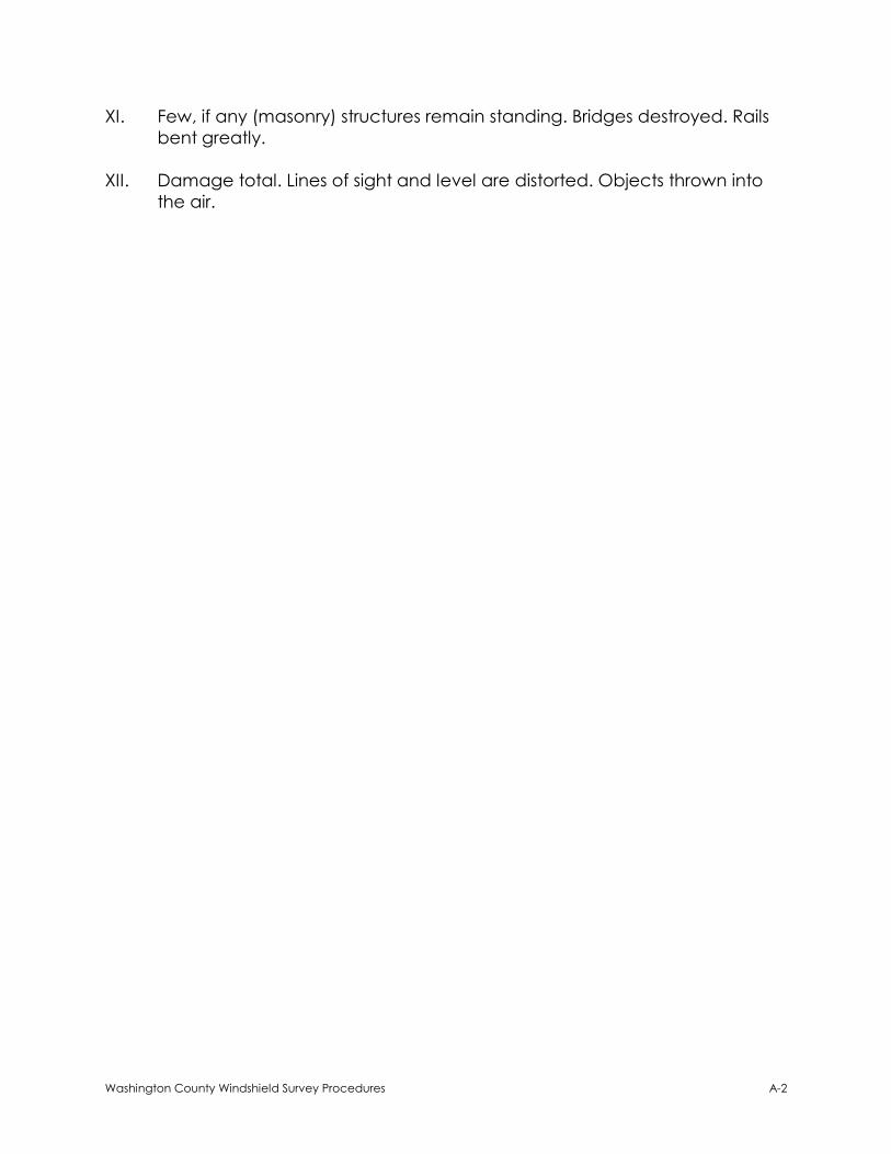
XI. Few, if any (masonry) structures remain standing. Bridges destroyed. Rails
bent greatly.
XII. Damage total. Lines of sight and level are distorted. Objects thrown into
the air.

Washington County Windshield Survey Procedures B-1
Appendix B
WASHINGTON COUNTY
WINDSHIELD SURVEY PROCEDURES
Critical Facility List
[Published Separately]

Washington County Windshield Survey Procedures C-1
Appendix C
WASHINGTON COUNTY WINDSHIELD SURVEY PROCEDURES
Community Codes, Sectors, and Agency Assignments
Assigned Sectors:
Community
Code
Community
Name Sector Community Description Agency Assignment
ALO Aloha
ALO01
Aloha – Bounded by W Baseline/SW Cornelius
Pass Rd/TV Hwy/SW 209th/SW Farmington/SW
Madeline/SW 188th/SW Kinnaman/SW 185th
Tualatin Valley Fire & Rescue
ALO02
Aloha – Bounded by SW Farmington/SW
Grabhorn/SW Gassner/SW 190th/SW Kemmer/
SW 175th/SW Scholls Ferry/SW Barrows/SW
Murray/SW Hart/SW Bany/SW 185th
Tualatin Valley Fire & Rescue
ALO03
Aloha – Bounded by TV Hwy/SW 185th/SW
Kinnaman/SW 188th/SW Madeline/SW 185th/SW
Bany/SW Hart/SW Murray. Includes Farmington
Square at SW Farmington and SW Murray.
Tualatin Valley Fire & Rescue
BAN Banks
BAN01 Banks/Roy/Manning/Buxton Banks Fire District #13
BAN01a Banks Well Pump House/Treatment Facility City of Banks
BAN01b Banks Water Treatment Slow Sand Filter City of Banks
BAN01c Timber Fire Station Banks Fire District #13
BET Bethany BET01
Washington County north of Sunset Hwy and
east and south of NW Cedar Hills/NW 113th/NW
Rainmont/NW 111th/NW McDaniel
Tualatin Valley Fire & Rescue

Washington County Windshield Survey Procedures C-2
Community
Code
Community
Name Sector Community Description Agency Assignment
BET Bethany
BET02
Washington County north of Sunset Hwy and
bounded by NW 174th/NW Laidlaw/NW 164th/
NW Springville/the county line/NW McDaniel/
NW 111th/NW Rainmont/NW 113th/ NW Cedar
Hills
Tualatin Valley Fire & Rescue
BET03
Washington County north of Sunset Highway
and bounded by NW Century/NW West Union/
NW 185th/NW Brugger/NW Joss/NW 164th/NW
Laidlaw/NW 174th
Tualatin Valley Fire & Rescue
BET03a TVFR Station 368 and Skyline Elementary Tualatin Valley Fire & Rescue
BTN Beaverton
BTN01n Beaverton – Bounded by Sunset Hwy/NW 185th/
W Baseline/SW Jenkins/SW Murray City of Beaverton
BTN01s Beaverton – Bounded by SW Jenkins/W
Baseline/SW 185th/ TV Hwy/SW Murray City of Beaverton
BTN02 Beaverton – Bounded by Sunset Hwy/SW
Murray/SW Farmington/Hwy 217 Tualatin Valley Fire & Rescue
BTN03
Beaverton – Bounded by Sunset Hwy/Hwy
217/Beaverton Hillsdale Hwy/the county
line/SW Scholls Ferry (not including ODOT
Facility at Hwy 26 and SW Scholls Ferry (PW047)
Tualatin Valley Fire & Rescue
ODOT Facility at Hwy 26 and SW Scholls Ferry Washington County
BTN04n
Beaverton – Bounded by Beaverton Hillsdale
Hwy/Hwy 217/SW Denny/SW Scholls Ferry/SW
92nd/SW Garden Home/SW Multnomah/the
county line
City of Beaverton
BTN04s
Beaverton – Bounded by SW Garden
Home/SW 92nd/SW Scholls Ferry/SW Denny/Hwy
217/SW Hall/SW Oleson
Tualatin Valley Fire & Rescue

Washington County Windshield Survey Procedures C-3
Community
Code
Community
Name Sector Community Description Agency Assignment
BTN Beaverton
BTN05e
Beaverton – Bounded by SW Farmington/SW
Murray/SW Allen/SW Hall/Hwy 217. Excludes
Farmington Square at SW Farmington and SW
Murray.
City of Beaverton
BTN05w
Beaverton – Bounded by SW Allen/SW Murray/
SW Scholls Ferry/SW Davies/SW Otter/SW
Cottontail/SW 130th/SW Scholls Ferry/Hwy
217/SW Hall
Tualatin Valley Fire & Rescue
CON Cornelius CON01 Cornelius including Forest Hills Lutheran School City of Cornelius
FOR Forest
Grove
FOR01
Forest Grove including Visitation School, Dilley
Elementary, and the JWC Water Treatment
Plan
City of Forest Grove
FOR01a Gales Creek Fire Station City of Forest Grove
GAS Gaston GAS01
Gaston/Scoggins/Laurelwood including
Scoggins Dam and Laurelwood Adventist
Elementary
Gaston Rural Fire District
HIL Hillsboro
HIL01
Hillsboro – Bounded by NW Evergreen/McKay
Creek/Dairy Creek/SW Wood/SW Hillsboro
Hwy/ SE Roundelay/SE Alika/TV Hwy/SE 10th/SE
Baseline/SE 12th/E Main/NE Cornell/NE
Grant/NE Jackson School including the Clean
Water Services Admin Facility
City of Hillsboro
HIL02
Hillsboro – Bounded by W Baseline/E Main/SE
12th/SE Baseline/SE 10th/SE Alika/SE Roundelay/
SE Morgan/Tualatin River/Gordon Creek/SW
River Road/SE Oakhurst/SW 229th/TV Hwy/
Cornelius Pass
City of Hillsboro

Washington County Windshield Survey Procedures C-4
Community
Code
Community
Name Sector Community Description Agency Assignment
HIL Hillsboro
HIL03
Hillsboro – Bounded by Sunset Hwy/NW Shute/
NW Bennett/NW 253rd/NW Evergreen/NW 264th/
NW Airport/NE Brookwood/NE Cornell/NW 185th
City of Hillsboro
HIL05
Hillsboro – Bounded by NW Evergreen/NE
Jackson School/NE Grant/NE Cornell/E Main/
NE Brookwood/NW Airport/NW 264th
City of Hillsboro
HIL06 Hillsboro – Bounded by NW Cornell/NE
Brookwood/W Baseline/NW 185th City of Hillsboro
JWC Joint Water JWC01 Eldon Mills Dam and Hillsboro Water Treatment
Slow Sand Filter Joint Water Commission
NOR North Plains NOR01 North Plains City of North Plains
NOR01a West Union Elementary School Tualatin Valley Fire & Rescue
SCH Scholls SCH01
Washington County bounded by SW
Farmington/SW Rood Bridge/SW Burkhalter/SW
Hillsboro Hwy/SW Midway/SW Vanderschuere/
SW Hillsboro Hwy/SW Scholls Ferry/SW River
Tualatin Valley Fire & Rescue
SHE Sherwood
SHE01
Sherwood – Bounded by SW Tualatin-
Sherwood/SW Cedarview/SW Trails End/SW
Edy/SW Elwert/Pacific Hwy/SW Brookman/SW
Old Hwy 99W/SW Timbrel/SW Sunset/SW
Murdock/SW Upper Roy/SW Division/SW Pine/
SW Sherwood/SW Century/SW Baler
City of Sherwood
SHE02
Sherwood – Bounded by SW Tualatin-
Sherwood/SW Baler/SW Century/SW
Sherwood/SW Pine/SW Division/SW Upper
Roy/SW Murdock/SW Oregon
Tualatin Valley Fire & Rescue

Washington County Windshield Survey Procedures C-5
Community
Code
Community
Name Sector Community Description Agency Assignment
TIG Tigard
TIG01 Tigard – Bounded by Hwy 99/SW McDonald/
SW Hall/SW Bonita/the county line City of Tigard
TIG02e
Tigard/Durham – Bounded by SW Bonita/SW
Hall/SW Durham/SW 81st/the PW Rail Line/the
Tualatin River/the county line
City of Tigard
TIG02w
Tigard – Bounded by SW McDonald/Hwy 99/
the Tualatin River/the PW Rail Line/SW 81st/SW
Durham/SW Hall
Tualatin Valley Fire & Rescue
TIG03
Tigard/King City/Bull Mountain – Bounded by
SW Walnut/SW 135th/SW Fern/SW Creekshire/SW
Horizon/SW Barrows/Scholls Ferry/SW Roy
Rogers/SW Beef Bend/SW 137th/the Tualatin
River/Hwy 99
Tualatin Valley Fire & Rescue
TIG04
Tigard – Bounded by SW Scholls Ferry/SW 130th/
SW Cottontail/ SW Otter/SW Davies/SW Scholls
Ferry/SW Murray/SW Walnut/SW Barrows/SW
Horizon/SW Creekshire/SW Fern/SW 135th/SW
Walnut/Hwy 99/Hwy 217
Tualatin Valley Fire & Rescue
TIG05
Tigard/Metzger – Bounded by SW Multnomah/
SW Oleson/SW Hall/Hwy 217/Hwy 99/the
county line
Tualatin Valley Fire & Rescue
TUA Tualatin
TUA01
Tualatin – Bounded by SW Tualatin/SW 124th/
SW Tualatin-Sherwood/SW Avery/ SW Teton/the
PW Rail Line/SW 90th/SW Tualatin- Sherwood/SW
Teton/SW Herman/SW 108th. Includes Pacific
Foods facility on SW 97th.
Tualatin Valley Fire & Rescue
TUA02
Tualatin – Bounded by SW Tualatin-Sherwood/
SW 89th/the PW Rail Line/SW Teton/SW Avery/
SW Tualatin-Sherwood/southeast from SW 124th
to the PW Rail Line/SW Tonquin/east from
Grahams Ferry/I-5
City of Tualatin

Washington County Windshield Survey Procedures C-6
Community
Code
Community
Name Sector Community Description Agency Assignment
TUA Tualatin TUA03
Tualatin – Bounded by the Tualatin River/SW
135th/SW Cipole/the PW Rail Line/SW Tualatin-
Sherwood/SW 124th/SW Tualatin/SW 108th/SW
Herman/SW Teton/SW Tualatin-Sherwood/I-5.
Excludes Pacific Foods facility on SW 97th.
City of Tualatin
WES West Linn
WES01
West Linn – Bounded by River Wood/S
Arbor/Willamette/Hidden Springs/Santa Anita/
Rosemont/Summit/Cornwall/Sunset/Sussex/
Fairhaven/southeast to the Willamette River
City of West Linn and
Tualatin Valley Fire & Rescue
WES02
West Linn – Bounded by Hidden Springs/
Rosemont/S Wisteria/S Woodbine/the Tualatin
River/the Willamette River/northeast to
Fairhaven/Sussex/Sunset/Cornwall/Summit/
Rosemont/Santa Anita
City of West Linn and
Tualatin Valley Fire & Rescue
WES03
Stafford/Pete’s Mountain/Tualatin – Bounded
by the Tualatin River/I-5/I-205/SW Newland/SW
Fir Grove/east to SW Brentwood/SW
Schaffer/SW Mountain/SW Stafford
Tualatin Valley Fire & Rescue
WIL Wilsonville
WIL01 Wilsonville – City limits west of I-5 and north of
SW Wilsonville Rd Tualatin Valley Fire & Rescue
WIL02 Wilsonville – City limits east of I-5 and north of
SW Wilsonville Rd Tualatin Valley Fire & Rescue
WIL03 Wilsonville – City limits south of SW Wilsonville
Rd. including Charbonneau City of Wilsonville

Washington County Windshield Survey Procedures C-7
Unassigned Sectors:
Community
Code
Community
Name Sector Community Description Agency Assignment
UNA Unassigned
UNA01 North/Northwest WashCo (outside assigned
areas) Unassigned
UNA02 Southwest WashCo (outside assigned areas) Unassigned
UNA03 South WashCo (East of GAS; West of SCH) Unassigned
UNA04 South WashCo (North and East of SCH; West of
ALO/TIG) Unassigned
UNA05 South WashCo (South of SCH; West of TIG/TUA/
SHE) Unassigned
UNA06 South WashCo (South of SHE; West of WIL) Unassigned
UNA07 Northwest ClackCo (Between West Linn and
Tualatin/Wilsonville – outside assigned areas) Unassigned

Washington County Windshield Survey Procedures D-1
Appendix D
WASHINGTON COUNTY
WINDSHIELD SURVEY PROCEDURES
Critical Facility Maps
[Published Separately]

Washington County Windshield Survey Procedures E-1
Appendix E
WASHINGTON COUNTY WINDSHIELD SURVEY PROCEDURES
Windshield Survey Form
Date: Sector: Surveyor/Agency:
What to look for:
Facility Time Damage
Category* Observations
Facility Name
Facility Address
Facility ID #
Facility Name
Facility Address
Facility ID #
Facility Name
Facility Address
Facility ID #
Miscellaneous Observations
Time Observation
*Damage Categories = None/Minor, Moderate, Severe (See reverse for descriptions)

Washington County Windshield Survey Procedures E-2
Damage Category Descriptions:
STRUCTURAL OBSERVATIONS MEDICAL OBSERVATIONS
None/Minor
No apparent structural damage, although repairs may be
required
Non-structural or superficial damage, e.g.,
broken windows, fallen plaster
Primary damage to building contents
No apparent fire or hazmat release
Moderate
Dangerous conditions observed or believed to exist
Structural stability questionable due to fracturing,
tilting
Displacement of building foundation
Minor/Controlled natural gas and/or water system
breaks
Minor hazmat release, contained onsite
Severe
Extreme hazard, collapsed or may collapse,
unsafe/unusable
Partial or total collapse of walls and/or ceilings
Significantly out of plumb
Obvious structural instability
Structure fire
Major/Uncontrolled natural gas and/or water
system breaks and releases
Hazmat release with offsite spread or threat
No evidence of significant medical problems
Unoccupied at time of incident
Minor injuries being handled on site
Significant medical problems noted
Fewer than 10 victims with major injuries requiring
stabilization and transport
A few hazmat exposure victims being treated on
site
Ambulatory victims with minor injuries but no
treatment capability on site
Mass casualty incident
More than 10 victims with major injuries requiring
stabilization and transport
Many hazmat exposure victims with no treatment
capability on site
Many ambulatory victims with minor injuries but no
treatment capability on site

Washington County Windshield Survey Procedures F-1
Appendix F
WASHINGTON COUNTY WINDSHIELD SURVEY PROCEDURES
Sector Report Form
Date: Agency:
Sector: Date/Time Sector Survey Completed:
Report No. For This Incident (e.g., 1, 2, 3, etc.):
Facility Time Damage
Category* Observations
Facility Name
Facility Address
Facility ID #
Facility Name
Facility Address
Facility ID #
Facility Name
Facility Address
Facility ID #
Miscellaneous Observations
Time Observation
*Damage Categories = None/Minor, Moderate, Severe (See reverse for descriptions)

Washington County Windshield Survey Procedures F-2
Damage Category Descriptions:
STRUCTURAL OBSERVATIONS MEDICAL OBSERVATIONS
None/Minor
No apparent structural damage, although repairs may be
required
Non-structural or superficial damage, e.g.,
broken windows, fallen plaster
Primary damage to building contents
No apparent fire or hazmat release
Moderate
Dangerous conditions observed or believed to exist
Structural stability questionable due to fracturing,
tilting
Displacement of building foundation
Minor/Controlled natural gas and/or water system
breaks
Minor hazmat release, contained onsite
Severe
Extreme hazard, collapsed or may collapse,
unsafe/unusable
Partial or total collapse of walls and/or ceilings
Significantly out of plumb
Obvious structural instability
Structure fire
Major/Uncontrolled natural gas and/or water
system breaks and releases
Hazmat release with offsite spread or threat
No evidence of significant medical problems
Unoccupied at time of incident
Minor injuries being handled on site
Significant medical problems noted
Fewer than 10 victims with major injuries requiring
stabilization and transport
A few hazmat exposure victims being treated on
site
Ambulatory victims with minor injuries but no
treatment capability on site
Mass casualty incident
More than 10 victims with major injuries requiring
stabilization and transport
Many hazmat exposure victims with no treatment
capability on site
Many ambulatory victims with minor injuries but no
treatment capability on site