wapato - state of oregon : oregon.gov home page : … thanks to greenworks landscape architecture...
TRANSCRIPT

COMPREHENSIVE PLAN
STATE GREEN WAYWapato
DRAFT May 2013


2013 Tryon Creek Comprehensive Plan i
Wapato State Natural Area
OregOn Parks & reCreaTiOn DeParTmenT salem, OregOn
Comprehensive Plan(Month) 2013
Volume 1

ii Tryon Creek state natural area
The mission of the Oregon Parks and recreation Department is to provide and protect outstanding natural, scenic, cultural, historic and recreational sites for the enjoyment and education of present and future generations.
Oregon Parks & recreation Department725 summer st. ne, ste Csalem, Or 97301-0792info Center: 1-800-551-6949egov.oregon.gov/OPrD/index.shtml
Title: Tryon Creek state natural area Comprehensive Plan, 2013
Prepared by: integrated Park services Division, Oregon Parks and recreation Department mark Davison, Planning manager Jaime english, senior Planner Julia Hill, assistant Planner Ben Hedstrom, assistant Planner
Publication rights: information in this report may be copied and used with the condition that credit is given to Oregon Parks and recreation Department. This report has been prepared for in-house use and will not be made available for sale. Photographs and graphics may not be reproduced for reuse without permission of the owners or the repositories noted in the captions.

2013 Tryon Creek Comprehensive Plan iii
Director’s letter

iv Tryon Creek state natural area

2013 Tryon Creek Comprehensive Plan v
Table of Contents
Chapter 1: Plan summary & Process 11
Chapter 2: Context 17
Chapter 3: resource assessments 21
Chapter 4: Visitor experience assessments 29
Chapter 5: agency mandates & approach 37
Chapter 6: Public involvement 43
Chapter 7: Opportunities & Constraints 49
Chapter 8: Values & goals 58
Chapter 9: Park Wide strategies and Operations 64
Chapter 10: management Zones 69
Chapter 11: reviews and approvals 81
Chapter 12: appendices 85

vi Tryon Creek state natural area
List of Figures
Figure 1.1 Traditional management approach Diagram 13Figure 1.2 Park Visitors inform Park management 14Figure 3.1 Composite natural resource Values 27Figure 3.2 Wildlife reserve Concepts 28Figure 4.1 Columbia/Willamette region 2011 User Occasions 30Table 4.2 management Unit estimated Visitors 30Table 4.3 Park and Forest agencies investment Priorities 31Table 4.4 Value for Benefits of Parks and Recreation Services 33Figure 5.1 Oregon state Parks in 2010 38Table 7.1 recreation Opportunity setting 52Figure 7.1 existing Conditions 55Figure 7.2 natural resource Opportunities and Constraints map 56Figure 7.3 Visitor experience Opportunities and Constraints map 57Table 10.1 Combining Opportunity areas into management Zones 70Table 10.2: Desired natural resource Conditions 72Figure 10.1 Comprehensive site Plan 79Figure 10.2 restoration Priorities and Prescriptions 80

2013 Tryon Creek Comprehensive Plan vii
Acknowledgements
OPrD executive staff: Tim Wood, Director John Potter, assistant Director, Operations roger roper, assistant Director, Heritage Programs Chris Havel, associate Director, Communications mg Deveraux, Project management Tasha Peterson, acting assistant Director, administration
OPrD staff: alex Phillips, Bicycle Coordinator andrea Berkley, natural resource Coordinator, Valleys region Ben Hedstrom, assistant Planner Brady Callahan, gis Program Coordinator Brenda schorr, assistant, administration Carrie lovellette, integrated Park services assistant Christal Florin, Park ranger interpretive, Tryon Creek Craig leech, Park Forester Dan Quigley Park ranger/Host Coordinator, Tryon Creek Dave Quillin, gis Technician Darrell monk, senior engineering Project manager David solomon, safety & risk management manager Deb Hill, Park ranger interpretive, Tryon Creek Dennis Comfort, manager, Valleys region Dorothy Brown-kwaiser, Park ranger interpretive, Tryon Creek Jaime english, senior Planner Jamie little, interpretive Coordinator Jim morgan, natural resource manager John mullen, Park manager, Tyron Creek Julia Hill, assistant Planner mark Davison, iPs manager Nancy Laughland, Office Coordinator, Tryon Creek nancy nelson, state Parks archeologist noel Bacheller, natural resource specialist / Botanist ron Campbell, master Planner rocky Houston, recreation Trails Coordinator scott stewart, engineering Project manager steven smith, architect steve Janiszewski, Operations support manager, Valleys region Tammy abbott, sign Coordinator Tammy Baumann, Volunteer services specialist Terry Bergerson, recreation Planner Vanessa Blackstone, Wildlife Biologist Vicki sink, interpretive Coordinator, Valleys region

viii Tryon Creek state natural area
Oregon Parks and recreation Commission: Congressional District 1 Davis moriuchi, Commission Chair
Congressional District 2 Brad Chalfant Congressional District 3 Jay graves, Vice-chair
Congressional District 4 sue musser
Congressional District 5 James Brown
east of the Cascades sharon rudi
West of the Coast range robin risley
advisory Committee: Carl & Patty axelsen, Watershed Coordinator, Tryon Creek Watershed Council adam Barber, multnomah County Planning sally Bird, Confederated Tribes of the Warm springs reservation Davis Cohen, executive Director, Friends of Tryon Creek Jennifer Devlin, City of Portland Bureau of environmental services Joan Frederiksen, City of Portland Bureau of environmental services Julie Osborne, Historian kevin Price, District manager, Portland metro District kim gilmer, Director, City of lake Oswego Parks & recreation Phil Hamilton, Board President, Friends of Tryon Creek state Park David Harrelson , Confederated Tribes of grand ronde Jane Hartline, sauvie island Conservation Partnership mel Huie, Trails Coordinator, meTrO regional Parks & greenspaces Dave & Dixie Johnston, land Use Committee Chair/Co-Chair, Collins View neighborhood association Cheryle kennedy, Confederated Tribes of grand ronde kammy kern-korot, Conservation Planner, West multnomah soil and Water Conservation District steve koper, Clackamas County Planning stacy livermore, north Valley Chapter Chair, Oregon equestrian Trails Donna matrazzo, sauvie island Conservancy Delores Pigsley, Confederated Tribes of siletz indians kena ramsey, Valley View riders Horse Club allan schmidt, Portland Parks & recreation stanley Buck smith, Confederated Tribes of the Warm springs reservation eirik Thorsgard, Confederated Tribes of grand ronde
Acknowledgements cont.

2013 Tryon Creek Comprehensive Plan ix
Travis Williams, executive Director, Willamette riverkeeper
Thanks to other OPrD and sHPO staff who contributed information, insight and ideas. also, thanks to greenWorks landscape architecture and Fletcher Farr ayotte inc. architecture and planning who worked on planning and design for the day use area and nature Center area of the park.
Contacts: mark Davison, integrated Park services manager 503-986-0744Dennis Comfort, Valleys region manager 541-872-5288

x Tryon Creek state natural area

Chapter 1: Introduction 11
Introduction1
A VISION FOR THE PARK
The Wapato greenway sits along the edge of Sauvie Island and is surrounded by an agricultural landscape that is incredibly popular with tourists. Wapato offers visitors a quiet, reflective, outdoor experience that benefits from the high quality and diverse natural resources on site. Fishing, birding, hiking, and picnicking are the most popular recreational activities. The natural resource diversity also provides an engaging outdoor learning space for visiting school groups. This plan sets out to strengthen Wapato’s already successful outdoor experiences and to enrich its natural resources through clear direction for management and restoration over the next 15 years.
OPRD understands that Wapato will succeed only if it enters this community ready to learn, earn trust, and provide necessary services. The park also needs help to achieve its challenging natural and cultural resource goals. The skills of established partners and efforts of community members are obviously crucial. This plan represents a shared vision among those living in Multnomah County who have attended public meetings and Oregon Parks and Recreation Department (OPRD), nonprofit Lower Columbia Estuary Partnership, and the citizens of Oregon.
In the Wapato plan, minor upgrades are identified for the existing picnic shelter, pathways, and parking area. A permanent bathroom facility is also recommended. The natural resources vision for the park includes the

12 Wapato Greenway Comprehensive Plan
re-establishment of a viable wetland for salmon and other species to re-inhabit and the restoration and reintroduction of native plant communities. The plan outlines a visitor experience that allows park users to observe and partake in the restoration of this dynamic riverside ecosystem.
NEED FOR A PLAN
A Comprehensive plan focuses on resource stewardship guidelines, recreation concepts, operational management, and community partnerships. It describes park management values, goals, strategies, and actions that will conserve the landscape and enable careful access to those lands. The park maps and project descriptions provide the public, the Oregon State Parks and Recreation Commission, and local governments with a basis for approval of the plan. The plan serves as the basis for park management and development; operational strategies provide park managers with a basis for effectively taking care of the park and its day-to-day business.
The contents of this plan will be submitted to Multnomah County staff for their approval. After the Comprehensive plan is adopted and approved by the public, Oregon State Parks and Recreation Commission and the two local counties, it becomes the basis for enacting the plan’s goals, strategies and actions. The plan can be updated only through an official amendment, an action that requires this same approval process. An OPRD plan is usually amended every five to twenty-five years, depending on the circumstances.
PLANNING FRAMEWORK
The Comprehensive Plan for Wapato State Park accomplishes three tasks:
1. Meeting OPRD’s legal obligation to provide a plan for local land use and state-level approval.
2. Setting the vision, goals, concepts and actions to guide park development and operation.
3. Establishes a library of assessments to help park managers succeed with their stewardship mission.
This plan works for a variety of audiences: the visiting public, park manager, county planners, local communities, and partner agencies. First and foremost, the Comprehensive Plan represents the vision of the public and describes their vision and intent for the park. The park manager at Wapato will use this volume to manage the park. Multnomah County will review this volume for compliance with the County Comprehensive Plans. Our partner agencies will work with us to ensure the plan is implemented. Local communities can use it in partnership with us to enhance the Willamette River Greenway as a place to live, and as a thriving, ecological system with minimal recreational use.
This plan contains the park vision and goals, and will guide overall park management. It also lists more specific strategies and actions. This plan, usually updated every 20 years, contains:
• Agency’s purpose for the park• Brief park history and regional context/role• Overview of park natural, cultural, and scenic
resources• Overview of park recreational uses and facilities• Overview of park operations• Summary of stakeholder and public partnerships • Summary of physical and operational opportunities
and constraints

Chapter 1: Introduction 13
• Park values and management goals• Strategies and actions based on the values and
goals; including resource prescriptions, recreation activities, supporting facilities, programs, staffing, and partnerships
Volume Two will define the vision for Wapato State Greenway in greater detail, including:
• Natural Resource Management and Action Plans• Cultural Resource Management and Action Plans• Scenic Resource Management and Action Plans• Visitor Experience assessments• Design Guidelines relating to development
proposals• Public Safety and Emergency Management Actions• Sustainable Management Plan• Community Engagement and Partnerships • Marketing and Concessions• Maintenance Management Plan • Administrative Operations
PLANNING PROCESS
The planning process for public involvement is also outlined in state rule. OPRD goes beyond the state rule to ensure extensive public consultation and input for this plan. In general, this includes:
• Informal and formal public and stakeholder involvement before issuing a final draft plan
• Formal hearings for reviewing the plan• Director and Oregon Parks and Recreation
Commission support for amending state rule to
include this plan• Approving the plan through local jurisdictional land
use
The first step is to confirm the department’s management intent and vision for the park. For new parks, this is usually outlined in a report to the Oregon State Parks and Recreation Commission before the property is even acquired.
Staff gathered information about resources and potential uses, including natural, historic/prehistoric, scenic, existing uses and recreational and interpretive opportunities, plus information about the local community and the surrounding region. The process included three rounds of public meetings in Multnomah County. Mailings and meetings with interest groups provided many other opportunities for public comment.
MEASURING SUCCESSMeasuring the success of a new park can be difficult. Implementing this plan will include several layers of analysis to determine how successfully OPRD has translated the needs of the local community, statewide community and the agency as a resource steward into discrete actions that uphold the department mission and adhere to the park vision. The primary method for determining success is to apply a traditional project management approach based on cost, scope, and schedule (Figure 1.1). The planning process identified many actions; each of these actions has costs, schedules,
Figure 1.1 Traditional Management Approach Diagram
COST
SCHEDULE
SCOPE

14 Wapato Greenway Comprehensive Plan
and scopes of work. The tasks will be refined and prioritized based on available budgets and park needs as Wapato State Park is established. The park manager, with the district and region manager, will prepare work plans to accomplish high priority items.
The planning process helps define the expected or desired visitor experience and helps identify successes and areas needing improvement. A broad community engagement effort—to reflect community and visitor needs and expectations—was essential to the planning process (Figure 1.2). The expected visitor experience becomes a measure of success that will help evaluate the implications of a change to cost, scope, or schedule.
The quality of the experience inherent in the visitor’s expectation can be analyzed in several ways. The park manager can use the visitor experience to help prioritize and schedule tasks that will help meet (or exceed) visitor expectations or improve the overall quality of the visit. In most cases this will be a simple comparison with facilities or recreation experiences.
Visitor comments from park advisory committee members and local stakeholders give a deep understanding of the visitor experience. Including the visitor experience as a measure of quality also helps capture some of the intangible elements of park development related to resource protection and enhancement.
Finally, measures also help evaluate the effects of changes to the park budget, and communicate those effects and their related trade-offs. Much of this analysis is contained in Chapter 9.
The finite budget for the park must be prioritized to accomplish a wide variety of tasks and actions. Due to changes on the ground, emergencies, and unanticipated park needs, annual plans will require changes. The criteria presented here can help identify ways that tasks and action plans can be adjusted with a conscientious effort to consider impacts to visitors and other resource values.
Figure 1.2 Park Visitors Inform Park Management
COST SCOPE
SCHEDULE
VISITOREXPERIENCE

Chapter 2: Managememt Zones 17
Context2
on THE EDGE
Wapato is intricately woven into a vast network of riparian ecosystems. Its unique location on the Multnomah Channel, just upstream from the Willamette River, provides a snapshot of the ever evolving riparian edge. The wetland at the heart of Wapato provides for a variety of fish species to harbor, turtles and amphibians to live, and an excellent destination for birds to touch down, feed, and nest. As a reserve, the dock and existing trail at Wapato deliver an opportunity for visitors to experience the rise and fall of the river and the many flora and fauna it breeds.
Visitors to Wapato can access the park from a gravel parking lot and trailhead located off of the Gillhan Loop Road on Sauvie Island. Just north of Portland off of Highway 30, Sauvie Island is a weekend destination for many urbanites especially during the autumn harvest and summer beach seasons. Sauvie Island residents have already established a great appreciation for this wildlife refuge and wish to let it remain as a local treasure for future generations.

18 Wapato Greenway Comprehensive Plan
For local residents Wapato Greenway is an unparalleled natural resource for recreation and access to Multnomah Channel. Additionally it is one of the few public natural areas on the island where hunting is not allowed, making it a safe choice for outdoor recreation during the hunting season. For urbanites, Wapato is currently the only area on Sauvie Island that does not require a parking permit, allowing public access to a natural area for everyone.
THE WILLAMETTE RIVER GREENWAY
The Willamette River is a vital, multi-purpose waterway that touches the lives of millions of people. It provides ports for commercial barges and oceangoing ships, irrigation for crops sold worldwide, an abundant fishery, and recreational opportunities. nearly 70% of oregonians live within 20 miles of the Willamette River, and some may not even realize it. All the more reasons to preserve, protect, and enhance its many shores. It is the responsibility of oPRD and surrounding communities to continue to foster an appreciation for the Willamette River its innumerous benefits.
Wapato sits within the Willamette River green way program area which identifies the need for scenic recreational and natural resources to be fostered and protected. That is why, in recent years, Lower Columbia Estuary Partnership has identified Wapato for an estuary enhancement project.

Chapter 2: Managememt Zones 19
§̈¦5
§̈¦84
§̈¦405 §̈¦84
§̈¦5
§̈¦405
UV120
UV08
UV99E
UV217 UV43 UV99EUV99E
UV99E
UV08
£¤30
£¤26
£¤30BY
£¤30BY
£¤26
£¤30
£¤26
MULTNOMAH
WASHINGTON
COLUMBIA
Portland
Hillsboro
Beaverton
Scappoose
Beaverton
Beaverton
Legend
Counties
City Limits
Parks and Green Spaces
Approximate Park Boundary
0 1 2 3 40.5Miles
¹

20 Wapato Greenway Comprehensive Plan
Chapter 3: Managememt Zones 21
Resource Assessments3
Park assessMents
OPrD prepares resource inventories and assessments as a basis for resource management and recreation planning. This chapter summarizes the findings of resource inventories and assessments for Wapato access Willamette river Greenway. assessments include natural (abiotic and biotic), cultural (historic and prehistoric), and scenic (landscape character and views). the ‘eco-region’ discussed in this chapter is the Portland Metropolitan area, the Willamette Valley ecoregion, and the sauvie Island area, including OPrD, private, and other public ownerships.
summary maps are included in this document for the major resource assessments in addition to the Composite natural resource Value assessment Map. Detailed resource maps and technical reports not published in this document are available at the OPrD headquarters office in Salem and on the OPRD web site.

22 Wapato Greenway Comprehensive Plan
Island). anthropogenic hydrological alterations have had significant impacts on the vegetation and ecology of the wetland and floodplain portions of the property.
Current VeGetatIOn Patterns
the study area’s vegetation is a combination of forested areas, emergent wetlands, woodlands, scrub-shrub wetlands, weedy shrublands, reed canarygrass meadows, non-native grasslands, and submerged and aquatic plant communities. Forest habitat types are varied in both age and species composition. Major forest types present in the study area include riparian hardwood forest, oak woodland, maple forest, Douglas-fir forest, and oak-ash forest. The reed canarygrass grasslands are primarily seasonally flooded. As spring water levels recede in the summer, the land that is exposed is mainly characterized by reed canarygrass. More upland grasslands have higher species diversity, but are almost completely non-native in species composition. Portions of the Virginia Lake complex of permanently and seasonally flooded areas also include wetter habitats that range from Bidens meadows to floating parrotfeather and lady’s thumb communities. Areas where Seasonal flooding is shorter-lived are usually dominated by either shrubland or forest, unless mowed and maintained as open.
the distribution and composition of the many plant communities and vegetative habitat types found are on property are described in detail in the 2011 vegetation inventory report.
LanDsCaPe COntext OF the Park
topographically, the study area is centered on low and relatively flat ground in the flood plain of the Willamette and Columbia rivers. the study area has very little variation, and is best characterized as low rolling land surrounding a wet depression known as Virginia Lake, which holds water for much of the year. elevation within the study area ranges from 9 to 63 feet above sea level. Much of the property is within the 100-year flood plain of the Willamette River.
General landcover types present include, open water, marshland, riparian forest, upland forest, grassy areas, and shrublands. While the vast majority of the property is undeveloped and natural, the study area includes many artificial features.
the immediate vicinity includes several other prominent natural areas managed by the Oregon Department of Fish and Wildlife, Metro, and the us Fish and Wildlife service. Much of the natural habitat land use is located along the mainland bank of the Multnomah Channel of the Willamette river and in a variety of locations on sauvie Island. these natural areas are well situated relative to each other, and provide collective function that adds more value than just the sum of their individual habitat values because of migration, dispersal, and other aspects of biological movement.
hIstOrICaL anD PrehIstOrIC VeGetatIOn Patterns
the broad vegetation types presumed to be present on much of the site prior to and soon after european-american settlement are assumed to be marshland, open water, riparian hardwood forest, Oregon white oak-Douglas fir forest, upland prairie, riparian and scrub-shrub wet shrubland, and wet prairie. Forest density and distribution changes are not known with certainty, but it is likely that dense coniferous forest is much more prominent on the property today than it was before european settlement. there is very strong evidence that the site’s vegetation was managed by native americans in the past, and this management probably involved burning and other treatments that would have resulted in reduced conifer stocking, more open savanna habitats, and wapato marshland (wapato was a staple food plant of most native americans along the Columbia and Willamette rivers, and sauvie Island was formerly known as Wapato

Chapter 3: Managememt Zones 23
WILDLIFe PresenCe anD usaGe
Wapato access Willamette river Greenway is a well-used wildlife area, particularly for marshland birds. The property provides habitat for a range of fish and wildlife species that includes 5 listed animal species.
some of the most important species to note that are either known to be present or for which presence is possible or likely include:
• Chinook salmon • Coho salmon• steelhead trout• Bald eagles• Columbia White-tailed Deer• Western Pondturtles• red-legged Frogs and other aquatic amphibians, • acorn Woodpeckers• slender-billed nuthatches• Western Bluebirds• Willow Flycatchers• a number of native Bees.
haBItat COnneCtIVIty
Connectivity is the degree to which a landscape helps or disrupts the ability of an animal to move and acquire resources (Fahrig and Merriam, 1985). Without habitat connectivity individuals may be unable to move between patches, and the population is more susceptible to disease, population pressures, predation, and extirpation from natural disturbance like fires and human-caused disturbances that impact their habitats. Continuing land-use changes as well as the emerging threat of climate change make the need for habitat connectivity even more critical, as many species will need to adapt to a changing climate by moving across the landscape.
The Willamette Valley has experienced significant habitat changes and landscape conversions, and few remnant natural areas remain. as a result, preservation and enhancement of the natural resources within Wapato is of critical importance in the larger network of the natural landscape. Wapato provides an important link in potential wildlife corridors spanning sauvie Island from sauvie Island Wildlife area, through private lands, to natural areas across the Multnomah Channel (Figure 1).
since most of Wapato is bordered by private ownership, providing habitat connectivity across private lands will involve extensive planning and agreements

24 Wapato Greenway Comprehensive Plan
with land owners, and may not be feasible. this reduces the potential connectivity for terrestrial species such as amphibians and small mammals; however, habitat connectivity for aerial insects, birds, fish, and large mammals to the surrounding natural areas is possible.
the sauvie Island Wildlife area draft site management plan was reviewed by OPrD staff to assist in development of management strategies that complement the management strategies. Wapato can provide connectivity for a number of wetland and grassland-obligate bird species that may not utilize the site for breeding (ODFW, 2009). In addition, a Backyard Habitat Certification program developed by the Portland audubon society, Lower Columbia Land trust, and Friends of tryon Creek state Park is increasing available habitat in the Portland metro area. these connections provide an outlet for dispersal for aerial insects and birds, and in some cases amphibians and reptiles. Wildlife movement from Wapato to the remainder of the island may be impaired by sauvie Island road, especially for slow-moving terrestrial species such as amphibians and reptiles. assessment of wildlife crossings at Wapato would be beneficial to understanding connectivity for these species. additional connections by land-use agreements with adjacent land owners would increase population stainability within the park, and should be developed where feasible.
aquatIC haBItats anD hyDrOLOGy
hydrological alterations affecting the property are very important from an ecological perspective. alterations that affect the property include:
• The advent of flood control and hydroelectric dams on timing and volume of the annual flood freshets in both the Willamette and Columbia rivers
• analysis of hydrology data from the last 100 years shows that overbank flooding has decreased radically as a result of man made impoundments upstream. Since overbank flooding is what supplies the Wapato property with the vast majority of its annual inundation, decreases and changes in timing of flood events can radically change the character of the properties wetlands.
• at least one drainage channel has been dug to drain the Virginia Lakes basin in the last 150 years, presumably to make more of the property suitable for agriculture.
hydrological alterations to the local landscape have generally decreased the duration and depth of inundation of wet areas, which decreases habitat value for birds and amphibians in addition to encouraging proliferation of certain invasive plant species and contraction of the extents of important marshland habitats.
eCOLOGICaL COnDItIOnMuch of Wapato access Willamette river Greenway is currently rated as being in poor condition, and around one fifth of the park is in marginal condition, mostly due to large-scale infestations of exotic plants. the best ecological conditions are located in dense forest and shrubland habitats without trail or road access and with little light penetration through the overstory canopy to support the growth of invasive plant species. restoration efforts are underway and have improved habitat quality in some important areas (particularly in oak savanna locations) but condition in these areas is still significantly degraded by invasive species.

Chapter 3: Managememt Zones 25
OVeraLL naturaL resOurCe VaLue ratInGsas a basis for natural resource related planning decisions for the park, OPrD natural resource staff rated the ecological value of existing plant communities, at-risk plant species, water features, and wildlife habitat. the distribution of these individual-resource values were mapped across the park landscape, and then overlaid to obtain a Composite natural resource Value Map. the values rating system has four levels ranging from highly valued (1) to very low value as functioning ecosystem elements (4). each of the four value ratings (1-4) indicates an appropriate level of resource management and the level of recreation that can occur for corresponding mapped areas of the park. areas of the highest recorded resource value (1) also have the highest level of protection and conservation value. the “Composite natural resource Value” map is included at the end of this chapter.
CuLturaL resOurCe VaLuesthe probability zone map for Wapato is completely yellow indicating a high probability for finding subsurface cultural resources. this particular greenway has never had a complete archaeological survey, and nothing has been reported to be found on the surface of the trails. There is a significant archaeological site about 1 mile upstream, sunken Village, that Village that is listed on the national register of historic Places. also, the Confederated tribes of Grand ronde, Confederated tribes of siletz and Confederated tribes of Warm springs have all indicated this area as an ethnographic location for the collection of wapato and have encouraged OPrD to manage the natural resources to encourage the growth of wapato.
VIeWPOInts, VIeWsheDs anD sCreenInG assessMent
Scenery at Wapato is defined by views across the wetland and of Multnomah Channel. scenery is heightened by the various natural conditions and the presence of wildlife species. some of these views include.
• Wetland/Virginia Lake view from wildlife viewing platform
• View of Multnomah Channel from outer trail lookout

26 Wapato Greenway Comprehensive Plan


Chapter 4: Recreation Assesment 29
Visitor Experience Assessments
4
RegionAl ReCReAtion
to help park providers know what kinds of new facilities and parks might be needed in a region, studies are undertaken to understand recreation trends and demands. these include assessment of the future recreational demand for different types of activities, how that demand changes over time, and surveys of public opinion about participating in future recreational activities. this section outlines regional recreational use estimates, trends and needs for the planning region that includes Multnomah County, as well as the entire state. Understanding regional needs provides a broad picture among all parks, public lands and park providers of the type of activities that will meet public demand in the region. the regional demand for Multnomah County indicates the hope for increased opportunity for wildlife viewing, interpretive elements, and trail extensions into the park. oregon State Parks is well placed to provide for this type of demand, which can include improved greenway amenities, including wildlife viewing areas.

30 Wapato greenway Comprehensive Plan
Wapato has been assessed relative to its location along travel routes and in relation to other parks. the potential for meeting recreational needs that may be appropriate at Wapato were assessed against the known resource values, and physical and infrastructure constraints at the site. Final recommendations about what will be provided at Wapato are outlined in Chapter 9, Parkwide Strategies and are described in detail in Chapter 10, Park Management Area Concepts of this plan.
RegionAl ReCReAtion PARtiCiPAtion eStiMAteS
the oregon outdoor Recreation Survey was conducted to estimate annual participation levels with recreation participation estimates were measured in “User Occasions.” A user occasion is defined as each time an individual participates in a single outdoor recreation activity. the boundaries for oregon Statewide Comprehensive outdoor Recreation Plan (SCoRP) Planning Region 2: Columbia/Willamette includes Portland where Wapato is located. table 4.1 lists those
0 100,000,000 200,000,000 300,000,000
Walking on local streets / Sidewalks
Dog walking / going to dog parks / off-leash areas
Walking on local trails / paths
Bicycling on roads, streets /sidewalks
General play at a neighborhood park / playground
Jogging / running on streets / Sidewalks
Relaxing, hanging out, escaping heat / noise, etc.
Sightseeing / driving o rmotorcycling for pleasure
Jogging / running on trails / paths
Walking / day hiking on non-local trails / paths
Columbia/Willamette Region 2011 User Occasions
Columbia/Willamette Region 2011 User Occasions
0
100,000
200,000
300,000
400,000
500,000
600,000
200220032004200520062007200820092010
TRYON CREEK STATENATURAL AREA
MILO MCIVER STATEPARK
Estimated Visitors Per Calendar Year
Figure 4.1 Columbia/Willamette Region 2011 User occasions (oPRD SCoRP DAtA)
Figure 4.2 tryon Creek Management Unit estimated Visitors (oPRD DAtA)

Chapter 4: Recreation Assesment 31
outdoor recreation activities that had the top annual participation estimates in 2011. the most popular activities occurring in this region include walking on local streets and trails, dog walking, bicycling, playing at a playground, running for exercise, relaxing and escaping heat or noise, and sightseeing.
RegionAl ReCReAtion PARtiCiPAtion tRenDS
Another method of identifying recreational demands is to look at how participation for a comparable set of activities changes over time to determine which activities are growing and which are becoming less popular. For the SCoRP analysis, recreation participation estimates from the 2002 oregon outdoor Recreation Survey were compared to participation estimates from the 1986-1987 Pacific Northwest outdoor Recreation Survey.
Below are the five outdoor recreational activities with the largest increase over time in participation (growth activities).
Participation growth activities in SCoRP Columbia Planning Region 2 & Willamette Planning Region 3 include:
• nature/Wildlife observation (+254%)• golf (+224%)• Using Playground equipment (+114%)• Baseball (+131%) • Sightseeing/Driving for pleasure (+69%)
the top growth activity, nature/wildlife observation, is an opportunity for Wapato. Additionally, 2011 SCoRP survey participants were asked about their opinions on priorities for the future in and near their community. Respondents were asked to rate several items for investment by park and forest agencies using a 5-point scale (5 = Highest priority need and 1 = lowest priority need).
0 1 2 3 4
Dirt / other soft surface walking trails and paths
Public access sites to waterways
Children’s playgrounds and natural material play areas
Off-street bicycle trails and pathways
Nature and wildlife viewing areas
Picnic areas and shelters for small visitor groups
Paved / hard surface walking trails and paths
Community gardens
Off-leash dog areas
Designated paddling routes for canoes, kayaks, rafts, driftboats
Children’s playgrounds and traditional play structures
Picnic areas and shelters for large visitor groups
Multi-use fields for soccer, football, lacrosse, etc.
Baseball / softball fields
Basketball courts
Outdoor tennis courts
Off-highway vehicle trails / areas
Park & Forest Agencies Investment Priorities for the Future
Mean (5 = Highest priority need; 1 = Lowest priority need)
Figure 4.3 Park and Forest Agencies investment Priorities (oPRD SCoRP DAtA)
Mean (5 = Highest priority need; 1 = lowest priority need)

32 Wapato greenway Comprehensive Plan
Figure 4.4 Value for Benefits of Parks and Recreation Services (OPRD SCORP DATA)
items were developed by the steering committee, representing several municipal-type areas and beyond. table 4.3 reports Columbia/Willamette Region results, with items listed in descending order by mean priority ratings. the top priority needs for Columbia/Willamette Region residents are soft surface walking trails, access to waterways, playgrounds with natural materials (natural Play Areas), off-street bicycle trails and nature and wildlife viewing areas. Picnic areas for small groups, paved walking trail, community gardens and off-leash dog areas rated high as well.
nine of the seventeen items mentioned as desirable provide opportunities for Wapato, with seven of the items ranking highest on the list. in consideration of the limited opportunities for some of the items mentioned near urban development, such as wildlife viewing or access to waterways, Wapato is of remarkable value to the immediate community.
SCoRP survey participants in the Columbia/Willamette Region that participated in outdoor recreation activities were also asked their opinions related to the benefits provided by park and recreation agencies. First, respondents were asked to rate each benefit type based on how valued it is using a 5-point likert scale (5 = Highest priority need and 1 = lowest priority need). table 4.4 reports Columbia/Willamette Region results.
RegionAl ReCReAtion neeDS ASSeSSMent
the 2008-2012 oregon SCoRP planning effort used additional methods to understand recreational needs. this included a county-level analysis to identify priority projects for grant funding.
RegionAl tRAil ASSeSSMentoPRD staff completed a series of nine regional trail issues workshops across the state, as part of the oregon trails 2005-2014 Statewide Action Plan. trail issues were defined as any high-impact issue related to providing recreational trail opportunities within the region. At each regional workshop, participants voted to identify top priority issues. An emphasis on the provision of non-motorized trail systems and water trails, statewide emerged as the top priority for trail users. trails require interagency partnerships to ensure good experiences for visitors and effective management of the sites and lands along them. Adequate trailheads are needed to support peak use and the desired amenity level.

Chapter 4: Recreation Assesment 33
non-motorized trails:• need for trail connectivity within the region
providing access from urban to rural trails, connections between public facilities, parks and open space and connections from state and regional trails to community trails.
• need for additional non-motorized trails (for all user types) – especially in close proximity to where people live
• need for additional funding for non –motorized trail acquisition and development. Potential strategies include allocation a certain portion of the state’s lottery fund; acquisition of fee title, easements, and land exchanges; and ways to allow users to pay for trail facilities and services.
At the statewide level, top non-motorized trail issues include:
• Statewide issue A: need for trail connectivity• Statewide issue B: need for trail maintenance• Statewide non-Motorized trail Concern 1: need
for more trails in close proximity to where people live
• Statewide non-Motorized trail Concern 2: need for additional non-motorized trails
Wapato acts as a significant connectivity gateway as a largely protected area of water and wilderness stretching along the Columbia River.
PARk nAtURAl, HiStoRiC, CUltURAl AnD ReCReAtionAl FeAtUReS FoR inteRPRetAtion
Naturalthe following natural features should be prioritized for increased interpretive programming at tryon Creek:
Wetlands and related riparian habitatextensive seasonal and permanent wetlands are found on-site. these habitats seasonally attract large populations of waterfowl and songbirds for nesting, feeding and migration stopovers.
0 2 4 6
Improve physical health and fitness
Preserve open space and the environment
Make your community a more desirable place to live
Enhance a sense of place and community
Preserve historical features in your community
Provide opportunities for social interaction
Value For Benefits of Parks and Recreation Services
Mean (5 = Highest priority need; 1 =Lowest priority need)Figure 4.4 Value for Benefits of Parks and Recreation Services (OPRD SCORP DATA)

34 Wapato greenway Comprehensive Plan
Amphibian habitat With extensive wetland habitats present, diverse populations of amphibians are attracted to this site and provide good opportunities for observing amphibians in their native habitat.
oregon white oak and hardwood habitat large oregon white oaks can be found in the uplands around the wetland habitats. other extensive hardwood forests grow on portions of the site.
Quality wintering bird and breeding habitat • the important Bird Area (iBA) Program is an
international program sponsored by Bird life international with support from the national Audubon Society (locally Audubon Society of Portland) that identifies outstanding lands for birds, and builds an interconnected network of areas that are recognized for their conservation value.
• Wapato greenway is part of the 12,000-acre Sauvie island iBA, which is one of over 9,000 iBA’s worldwide. Since 2009, systematic bird counts have been completed by volunteers (“citizen scientists” – citizen’s trained in the collection of wildlife and environmental information) at specific locations in the park tallying nearly 100 species of birds. the park area contains important wintering and breeding habitat for waterfowl and song birds.
Culturalthe following natural features should be prioritized for increased interpretive programming at tryon Creek:native American use and cultivation of the Wapato
• Historically, the native peoples who lived here on Sauvie island were Chinookan and spoke the Chinookan language and, according to a national Park Service report, were a part of “one of the highest population densities” of the lower Columbia River area during pre-contact times (http://www.oregon.gov/oprd/HCD/docs/courier_206.2.pdf).
• the island was an important source of Wapato – a wild potato cultivated in wetland areas by native peoples. Some documentation shows that this food source was traded up and down the Columbia River with other tribes.
Multnomah Channel Access (fishing and boating)located directly on the Multnomah Channel, the park provides access to the water from the land and vice versa at Hadley’s landing. As a stop on the Willamette
River Water trail, Wapato greenway attracts boaters, kayakers and yachtsmen to stretch cramped legs on the land. Anglers are also attracted to this river access site for fishing.
inSeRt Recreation Activity table
oVeRVieW oF ViSitoR MARketing AnD AUDienCe iDentiFiCAtion
Visitor Group DescriptionsVisitors to Wapato greenway can be divided into the following interest groups
Primary: • Sauvie island residents• Day travelers to Sauvie island (generally
Portland Metro residents)• Anglers• Birdwatchers• Boaters along Willamette Channel (Hadley’s
landing)

Chapter 4: Recreation Assesment 35
Secondary:• equestrians • interpretive program attendees (i.e. bird walks,
etc.) • School groups – field trips (seasonal) • organized groups (picnic shelter)
the following visitor groups potentially could be attracted to the site with programming and/or outreach:
• Arts Community Members – plein air painters, videographers, photographers
• Yacht/boating community – increasing the number of visitors currently using Hadley’s landing
Desired visitor experienceWhat experiences do visitors want when they visit Wapato greenway? the matrix below summarizes the interests and desires that particular visitor groups may have for their visit. To confirm these assumptions, visitor surveys would need to be conducted in the park.
Desired Experience at the ParkTrail walkers & hikers: A quiet and peaceful experience enjoying being outside with family and friends; wayfinding; marked trail directions; adequate parking; free location to explore Birders: Ability to see birds in a natural setting without
disturbances; location listing and directions in birding guides; safe trails and wayfinding; bird checklist; adequate parking Groups: enjoy being outside in a safe and comfortable setting; restrooms; clean picnic shelter; advance reservations for shelter; pack in – pack out information in advance; adequate parking Boaters: A place to land to take a break with restrooms; gathering for overnight stays and social events Locals: Free location on the island to explore and walk

36 Wapato greenway Comprehensive Plan

Chapter 5: t 37
Agency Mandates & Approach
5
The Mission
The mission of the oregon Parks and Recreation Department is to provide and protect outstanding natural, scenic, cultural, historic and recreational sites for the enjoyment and education of present and future generations. This gives the agency a dual mandate: serve people by operating the state park system and protect park resources so future generations may also understand and enjoy them.
each of our parks is an individual place where people play, picnic, camp, rest, hike, renew and everything in between. They are an everyday reminder of the things that make oregon great, and their very existence is a testament to what oregonians collectively value.
oregon’s outdoor recreation and cultural heritage values are explained in state law; oregon Revised statute Chapter 390 opens by stating the well-being of oregonians is in large part dependent upon access to the state’s outdoor recreation resources for their physical, spiritual, cultural and scientific benefits.

38 Wapato Greenway Comprehensive Plan
The oregon Parks and Recreation Department is empowered by state law to provide outdoor recreation and heritage programs and plans. The oregon state Parks and Recreation Commission (the department’s citizen oversight body), positions the agency to function at a high level by aligning programs to the powers and duties granted by state law, and by observing and planning for emerging trends. Those laws direct the department to focus on four areas:
1. 1. state Park system: Create and run a state system of parks that protects and manages resources in order to provide recreation opportunities.
2. 2. natural resources: exercise forward-thinking, sustainable land stewardship in state parks and along ocean shores and state scenic waterways. Protect state park soils, waters, plants and animals.
3. 3. statewide recreation advocate: The agency is oregon’s lead advocate for outdoor recreation. Through research, financial and technical assistance, oPRD provides an oregon context for federal, state and local governments to collectively fulfill their outdoor recreation-oriented missions.
4. 4. heritage Programs: Work to preserve and protect oregon’s heritage and historic resources.
The CenTennial hoRizon
The Centennial horizon—a vision document that looks ahead to 2022 and the 100th anniversary of the state park system—is a series of principles developed to guide the work and priorities of the oregon Parks and Recreation Department in fulfillment of its mission. Eight principles compose the Centennial horizon:
• Principle one – save oregon’s special Places• Principle Two – Connect People to Meaningful
outdoor experiences• Principle Three – Taking the long View• Principle Four – engage People Through
education and outreach• Principle Five – Build the state Park system with
Purpose and Vision• Principle six – attract and inspire Partners• Principle seven – Prioritize Based on the Vision• Principle eight – oregon’s Parks will be Tended
by People Who love Their WorkThe first three principles play a substantial role in park acquisition, planning and development. The remaining five principles support the first three by offering more specific direction for park operations and programs. Each principle is more fully defined by a series of strategies and actions that change over time as opportunities arise. The full document is available at the department web site http://www.oregon.gov/oPRD/.
Figure 5.1 oregon state Parks in 2010 (PaRK sYsTeM Plan)

Chapter 5: t 39
The sTaTe PaRK sYsTeM
Three criteria define different kinds of state parks: the natural setting, facilities and primary purpose. These criteria help oPRD plan the management and visitor experiences at each park, and combine to create nine types of state park system properties: parks, recreation areas/sites, scenic corridors/viewpoints, greenways, heritage areas/sites, natural areas, trails, and waysides. state scenic waterways are a special category; the state doesn’t own scenic waterways, but works cooperatively with the property owner to preserve each waterway’s scenic and recreational qualities.
The oregon state park system contains more than 100,000 acres, nearly all of it natural resource-based. There are more than 300 properties in the system, including 174 developed for day-use, 50 campgrounds, and 110 undeveloped parcels along the Willamette River Greenway.
2012 PaRK sYsTeM Plan
The oregon state Parks and Recreation Commission has been engaged in doing long-term business planning for the state park system. They have focused on developing a greater understanding of how the park system functions and what financial opportunities and challenges are likely over the next ten years. The Commission has reviewed the current business model; the relative mission impact and economic viability of various park system activities; the ways in which the park system creates value and wealth for the state; and projections of future revenues and expenditures.
a number of strategies have been examined and refined about how best to sustain the park system and to continue and improve its valuable contributions to the state economy and to the quality of life for oregonians. These are summarized in a set of policy directions in the following areas: service delivery, park system maintenance, park system enhancement, workforce maintenance, and park system funding. The park system plan summarizes this work, and is intended to be used to guide investment, decision-making, and staff effort. The state park system generates significant wealth and value in oregon, and good decisions today can keep this source active and contributing.
sYsTeM MainTenanCe sTRaTeGY
The strategy for maintenance of the park system is to:•Maintain up-to-date land and facility condition and
mission effectiveness assessments;•Consider profitability, mission impact, and economic
activity prior to every maintenance investment decision to reduce under-performing assets and related activities;
•Complete preventive maintenance on facilities with high mission impact; and
•Reserve and dedicate a portion of earned revenues to a fund to be used for preventive maintenance.
The metrics for evaluating system maintenance includes:•Percent of scheduled preventive maintenance tasks
completed;•Ratio of facility-closure months to total park facility
program months;•Percent of lands and facilities with condition
assessments less than five years old;•asset condition index; and•Ratio of under-performing assets to total assets.
sYsTeM enhanCeMenT sTRaTeGY
The strategy for enhancement of the park system is:•Create new projects, parks, programs, and services
without expanding existing department staff;•Focus land acquisitions on improving performance
of existing parks and addressing under-served markets; and
•Create opportunities for new trails, water access sites, nature viewing, and learning about history by finding internal savings and generating external support.
Determinations about system enhancement investments should rely on many of the criteria provided in the section above. Where enhancements can bring a lower performing property more in line with these criteria, they are better enhancements to consider. The system enhancement metrics for consideration are:
•Current operating expenditures for previous biennium enhancements;
•Change to park system staffing levels;•Percent of parks with significant in-holdings,
adjacent unprotected natural areas, or access problems;
•Percent and density of oregonians within a 60- minute drive of five or more destination parks; and
•Value of external support towards capitalization of enhancements.

40 Wapato Greenway Comprehensive Plan
ResouRCe ManaGeMenT Role
The natural resources staff of the oregon Parks and Recreation Department is responsible for land stewardship, marine conservation and the rocky intertidal shores, several permit programs, department-wide resource policies, and park plants and animals. We strive to provide a safe environment while maintaining the natural beauty and historic importance of our parks.
oPRD is committed to managing the natural, scenic and cultural resources within the oregon state Park system. The agency writes plans and conducts management to balance resource protection with recreation use; resources are the essential foundation for nearly all forms of recreation.
The following categories best sum up oPRD’s approach to resource stewardship:•Forest health•Fish & Wildlife•ecosystems•invasive species•Protected species•natural heritage sites•national Register of historic Places, sites and
Districts•historic Buildings•Cultural landscapes•iconic oregon Views and scenic Corridors
ResouRCe ManaGeMenT Role
The natural resources staff of the oregon Parks and Recreation Department is responsible for land stewardship, marine conservation and the rocky intertidal shores, several permit programs, department-wide resource policies, and park plants and animals. We strive to provide a safe environment while maintaining the natural beauty and historic importance of our parks.
oPRD is committed to managing the natural, scenic and cultural resources within the oregon state Park system. The agency writes plans and conducts management to balance resource protection with recreation use; resources are the essential foundation for nearly all forms of recreation.
The following categories best sum up oPRDs approach to resource stewardship:
• Forest health• Fish & Wildlife• ecosystems• invasive species• Protected species• natural heritage sites• national Register of historic Places, sites and
Districts• historic Buildings• Cultural landscapes• iconic oregon Views and scenic Corridors
Role as ReCReaTion aDVoCaTe
oPRD connects people to meaningful outdoor experiences by protecting oregon’s special natural and historic places. This inherent tension between recreation and preservation, between the needs of today and tomorrow, has always defined the mission of Oregon state Parks. oRs 390.010 declares the state’s broad policy toward outdoor recreation. in summary:
5. 1. Present and future generations shall be assured adequate outdoor recreation resources coordinated across all levels of government and private interests.
6. 2. The economy and well-being of the people are dependent on outdoor recreation.
7. 3. outdoor recreation opportunities should be increased commensurate with growth in need in the following:
• oregon’s scenic landscape• outdoor recreation• oregon history, archaeology and natural
science• scenic roads to enhance recreational
travel and sightseeing• outdoor festivals, fairs, sporting events
and outdoor art events• Camping, picnicking and lodging• Tourist hospitality centers near major
highway entrances to oregon• Trails for hiking, horseback riding,
bicycling and motorized recreation• Waterways and facilities for boating,
fishing and hunting• Developing recreation in major river
basins• access to public lands and waters having
recreation value

Chapter 5: t 41
• Development of winter sports facilities• Recreational enjoyment of mineral
resources.
PlanninG FRaMeWoRK
In a critical first step for a park-specific plan, oPRD staff compiles data from department and other statewide or regional plans. This background information is used as a lens through which the park plan, like this one for Wapato Greenway, is first shaped. This data is used to inform and develop a framework for the park plan, then taken to the public for comment and discussion. Public advice and goals of the statewide system are then synthesized to produce the values, goals, strategies, and management actions to become the comprehensive, long-term plan for a park like Wapato:
• A park-specific plan therefore includes information on:
• Mission and mandates that define the role of oPRD (oregon Constitution, oregon Revised statutes, and oregon administrative Rules.)
• oPRD goals and objectives (Centennial horizon, Commission investment strategy, legislative Performance Measures, and oregon
Benchmarks.)• existing oPRD organizational structure and roles
of visitors, volunteers, staff, external parkland managers, and other partners.
• statewide Comprehensive outdoor Recreation Plan, state Trails Plans, Regional interpretive Frameworks
This background information defines the context for a state park comprehensive plan.

42 Wapato Greenway Comprehensive Plan
Values BaseD aPPRoaCh
a critical component to that process is the interest of the public, and the stakeholders and partners that have interest in the property. as a state agency accountable to the public, oPRD seeks to engage the community in a discussion to develop a sense of public interest, concern, and desired experience. During the Wapato process, the community was asked to develop a value hierarchy, to help guide and define proposed management actions. The agency looks to the community to help identify potential opportunities, conflicts, and desired outcomes for the property. The values developed in the public process help relate a sense of place to potential outcomes for management actions. These values help to develop an analysis framework to view the resource inventories and recreation assessments, so that a better sense of future condition or experience can be defined that is relevant to the landscape.
The values statements that were identified by the public were:
Value 1: NatureWe value Wapato as a natural refuge with a focus on water reconnecting Virginia lake to the Multnomah channel.
Value 2: Visitor ExperienceWe value the Wapato landscape, its natural character, and the enjoyment it brings to the lives
of those who experience it. We value outdoor recreation at Wapato and the contribution it provides to a happy, healthy, stress-reducing lifestyle.
Value 3: TraditionsWe value the history and experiences at Wapato that have shaped the landscape and our understanding.
Value 4: Community BenefitsWe value how the parks can strengthen local communities, improve health, and benefit their economies.
suMMaRY
The oregon Parks and Recreation Department staff is continually involved in the long-range review of state park system properties. a Comprehensive Plan is an assessment of resource and recreation opportunities, and management recommendations. The plans include management guidelines for each park’s natural, cultural, scenic, and recreation resource values, goals, strategies, and actions.
in the following sections the layers of analysis will be developed and discussed in greater detail, so peoples’ values and park goals as well as management strategies and actions can be understood in terms of the agency mission, landscape condition, and public needs and values.
Chapter 5: t 43
Public Involvement6
OppOrtunities FOr FeedbaCk
the issues summarized in this chapter were compiled with input from an advisory committee, Oprd staff and consultants, local officials, affected agencies and interest groups, tribal representatives and members of the public. Understanding the community needs and public expectations of a new park is an essential element of creating a comprehensive plan. During the process for the Wapato Greenway plan, Oprd has implemented approaches to maximize the opportunity for comment and issue identification. The opportunities to comment and efforts to raise awareness have included:
• Extensive public meetings scheduled to increase awareness and gather comments including three rounds of local public meetings on Sauvie Island.
• Creation of an extensive mailing list• press releases• Written-comment periods• A web site with interactive comment capability• Special meetings with relevant stakeholders• Engagement with neighbors groups to comment
on park proposals• issues raised and captured in the resource
assessment process • Advisory Committee made up of locals, agency
partners, resource professionals, community leaders to provide guidance and comment

44 Wapato Greenway Comprehensive plan
• Oprd Commission input• Meetings with OPRD staff for guidance and
comment• Media releases to increase awareness of the
planning process• Newsletter to mailing list
Many of these opportunities yielded excellent feedback and comments that are reflected in the overall planning document. This section addresses the issues that were identified during the outreach process and summarizes responses to these issues.
COMMents suMMary
During the planning process, OPRD reviewed hundreds of public comments that came from public meetings, an advisory committee, an official web site, correspondence, phone calls, partner agencies, ORPD staff, and informal external sources (such as online responses to news stories). The public discussion is summarized below and informs the values, goals and management strategies contained in the following chapters of the plan. Five major categories emerged from the public discussion: general comments, recreation needs, natural resource concerns, community values, and management issues.
General
the comments frequently relate to the operation of the agency and the state park system, such as funding for park development, how the parkland would be acquired, how the planning process works or general thoughts about how the park should be developed. Specific answers for frequent questions in these comments have included:
Why the need for a park comprehensive plan?In order to maintain this park in accordance to OPRD’s Centennial Horizon plan, mainly to connect people to meaningful outdoor spaces and create management plans that allow long term health of the natural area, a plan must be created to meet current and future generation’s needs. A current vision for the park needs to be defined to guide future management and improvements.
Specifically for Wapato, this means considering existing park amenities such as the access dock, parking, and trails and making sure that the strategies for maintaining them are in line with interpretation, cultural, scenic and recreation strategic goals. Updates to the park in the comprehensive plan should align with recreation opportunities in tandem with natural resource management and restoration efforts.
Is this going to be an adaptive management plan or a set plan?The plan is adopted through our Commission and Administrative Rules process and then we work with the county for land use. The ability to have a flexible park plan is very important so it can adapt to varying conditions over time.
How do you fund the development and day-to-day operations?Oregonians decided to dedicate 7.5% of lottery funds to state parks in 1998. Most of the lottery funds are used to repair and improve existing state parks. State parks are not funded by tax dollars.
We don’t receive any tax dollars, but most of our day-to-day park funding comes from three places:
• Visitor fees from campgrounds and day-use areas
• a portion of rV license fees• 7.5% of the lottery funds are dedicated by
voter passage of Measure 66 in 1998 and reconfirmed in Measure 76 in 2010.
We use these funds to provide recreation and protect resources on more than 100,000 acres across the state. Even though our 2009-2011 budget is lower than it was in 2007-2009, cost-effective management has allowed Oregonians to enjoy well-maintained, open parks during the economic downturn.
The comprehensive plan is a good opportunity for OPRD to evaluate the park and continue to use methods and materials that can be maintained affordably over the long term.

Chapter 5: t 45
reCreatiOn
the most frequent comments we received revolve around the types of recreational opportunities that will be available at the park. The planning process is an excellent time to identify community needs or expectations for specific types of recreation or experiences. The result of these comments can be seen in the General Plan map in Chapter 9, where recreational opportunities are identified, and come largely from the expressed needs of those who participate in this process. Some of these comments include:
“Dog walking should be added.”
“Another item that is important is expanding the interpretive signs. Partner with Audubon on these, cultural signs are really important.”
OPRD planning staff works with resource experts, recreation advocates and local planning officials, and the Oprd commission to identify if these types of activities are consistent with the resource protection goals of the park, the county or state planning ordinances and technically feasible. In some cases recreational development may be considered but excluded from the plan due to constraints in one or more of these areas. In other cases the recreational opportunity is possible but will be developed over
time. In all cases the issues of recreational access are considered very carefully to ensure that the recreational character of the park matches the landscape and the need.
natural resOurCes
Many issues that were identified as a result of the Wapato planning process relate to the interaction of recreation and the natural landscape. Wapato is a special place because of the beauty of the landscape and the unique opportunity for people to experience it in proximity to an urban environment. This is a challenge unlike any other OPRD property. OPRD will continue to work very hard to help restore those areas that have restoration potential, and protect those areas that offer outstanding natural or scenic qualities. That strategy is supported by many of the received comments:
“Wow! I am excited about the changes coming to “my” Wapato greenway. Over the 15 years I’ve tramped there, I’ve become sadder and sadder about the suffering of that little piece of landscape. The next 15 years are going to be wonderful. To the good news about the restoration ahead! Double luck!” - Sheilah T.
“I am particularly concerned about carp and other river organisms entering into the lakes, changing the

46 Wapato Greenway Comprehensive plan
lake’s present ecology, which supports a large variety of ducks, snipe, greater and lesser yellowlegs, red-winged blackbirds, geese (regularly including Dusky Canada), herons, great egrets, bald eagles, and the passerines that are around the area.” - Bill T.
“Consensus seems to be that carp will enter and cause damage, but also that there are still significant populations of native water fowl, fish, vegetation and herptiles benefitting from those sites. The approach we have taken is to restore a balance between management for as many of the important species at Wapato Access as possible. The situation at these other sites suggest that connecting Wapato Access is the best way to accomplish this goal, despite potential issues with carp.” – Marshall Johnson, Principle Restoration Ecologist, Lower Columbia River Estuary Partnership
“Wapato is part of a larger network of remnant natural areas that comprise what is left of the lower Columbia River Floodplain. Significant habitat changes and landscape conversion of natural areas in the greater Willamette Valley and in this floodplain has made preservation of the integrity of places like Wapato all the more critical. We recommend that the management plan devote a section to describing the
system of natural areas in which Wapato is embedded and strategies for developing an integrated approach to managing this system.” -- Bob Sallinger and Mary Coolidge Conservation Director and Assistant Conservation Director, Audibon Society of Portland
The outstanding natural features of Wapato are essential to the recreational experience. Oregon Parks and recreation department has the unique role of providing recreational opportunities that are enhanced by the surrounding natural and cultural resources. Many of the proposals in this plan are designed with the intent of preserving or enhancing those resources so that the recreation experience remains outstanding.
COMMunity
Another large segment of comments relate to the place that Wapato holds in the local communities that surround it. While many visitors from outside the region visit the park, the residents of southwestern Sauvie Island consider the park as a local or backyard resource. OPRD has sought to have this park continue to reflect the character of all of these communities.

Chapter 5: t 47
This is proven in OPRD’s efforts to identify community partnerships. Members of the community have also provided comment and input on the ways that Wapato could continue to be integrated into the surrounding community.
“I think that State Parks missed an important opportunity in making these changes in the park without first bringing in some stakeholders, posing things and discussing them. Even the interpretive signs seem to not have a lot of really interesting or valuable information, or much in the way of verve, “oh, wow!” aspects or being fun to read. (Bringing in) stakeholders as part of the process, involved from even the concept stages will allow a lot of storylines to emerge from their ideas, expertise and experience. Wapato has an abundance of people, including wildlife biologists and excellent birders, who are exceedingly familiar with the site and have a great love for it. – Donna M.
“I think Wapato’s proximity to a major urban area, Portland, makes it a wonderful learning lab and opportunity for education and eco-tourism in our own back yard. Oregon State Parks belong to all Oregonians. Not all of us can live on Sauvie Island, but we can recreate and recharge ourselves by spending time in nearby nature. I understand the desire to manage park users and minimize their impacts to nearby residents and I support that.” – Caroline S.
As the planning process moves forward OPRD will be looking for ways that the agency can be a resource for local groups and interests. We hope that the park continues to be a valuable resource for the region.
ManaGeMent issues
During the planning process issues, questions, or concerns are often raised about the management practices at the site. Answering these questions can often be difficult for park development because there is no ‘silver bullet’ cure for most of the park’s issues like the availability of parking and eradication of invasive species.
“The park area use has drastically increased - and will no doubt continue to do so. This year, several weekends in Jan-Feb (before summer has started) the parking lot and roadside have been packed with vehicles on the weekends. Containing/limiting
the parking spaces, and doing something that keeps cars from being on the shoulders would be beneficial as opposed to unsightly “no parking” signage, which the County previously suggested” - Cindy R.
I think it is a good idea to have a restroom on the site. I have mixed feelings about where it should be. Having it near the shelter would minimize opportunities for vandalism and trash dumping by people who are not actually using the park. On the other hand, there are few places on the island where bicyclists and other island users have access to toilets, and when they are desperate, they duck behind trees and shrubs on landowner’s property. A public toilet at the park could help prevent this. -- Jane H.
The issues raised by the comments in this group will be very important to help identify the best ways to manage the site over time. Not all of the issues can be addressed completely in the planning process. OPRD hopes to find the best way to continue to work through these issues, and continue to provide visitors and the community with the best service possible.
the summary of the comments presented here is not exhaustive, but is meant to provide context for the way that public input has shaped the plan. OPRD staff will continue to develop and manage the site based on public input.

48 Wapato Greenway Comprehensive plan

Chapter 7: Opportunities and Constraints 49
Opportunities & Constraints7
Understanding the site
Strategies for a successful park arise from a thorough understanding of the site’s opportunities and constraints. The master plan for Wapato digests these elements, determines their respective values, and defines methods for preserving and protecting natural and cultural resources while providing access to the greenway. Ever mindful of the opportunities and constraints, this plan defines areas of the greenway to be set aside for resource protection and restoration, and those that will focus on recreational uses and facility development. These two basic needs often merge on the ground, and the plan then serves as a set of goals demonstrating how recreation and resource management might coexist.
OPRD first determines the intent for the park based upon the importance of its resources and the potential for recreational access to those resources (or resources adjacent to the park). The park’s classification (as a greenway, state park, state recreation area, state natural area etc.) and preliminary management goals approved by the OPRD Commission reflect this general intent. OPRD refines this intent through detailed inventories of the park’s resources, by evaluating appropriate recreation opportunities, and through feedback from the public.

50 Wapato Greenway Comprehensive Plan
Willamette greenWay
Wapato is one of many public parklands along the Willamette River Greenway, a statewide planning goal mandated in 1975 to “protect, conserve, enhance, and maintain” the qualities of the Willamette River. Its location is particularly well suited for hiking, bird watching, and fishing. The parcel is now a popular local destination for many types of outdoor enthusiasts in addition to a generous refuge for wildlife.
As a Greenway the natural resource values and opportunities are especially important in the planning of the site. The Natural Resource Plan denotes the various Opportunity Areas within Wapato’s single management zone. Each has its own list of priorities including the removal of invasive species and restoration of existing habitat.
natUral resOUrCe OppOrtUnities & COnstraints
A composite map of the natural resources shows the current condition of specific areas around the park in addition to factors including; soils, terrain, and hazards. The natural resource management prescription is defined by prioritizing the conservation of high value habitat and restoring lower value areas. Natural resource goals become the priority, dictating the degree and type of recreation available throughout the park.
Assessments are made of the park’s existing character and opportunity areas are based on information derived from:
• Composite natural resource values; • Hazards, topography, soils;• Cultural resources;• Landscape character; • Important views and viewpoints; • Roads, utilities and existing facilities;• Recreation (and interpretive) opportunities at the
park; Operational needs; and• Opportunities and constraints outside the park
boundary.
The Natural Resource Opportunities and Constraints Map delineates the most appropriate places in the greenway to provide for resource protection and different levels of recreation compatible with that goal. (See the Natural Resource Opportunities Map Figure 7.2, for locations of the low to high value resources.)
high natural resource Opportunity areas are protected and need to be conserved through monitoring. Limiting trail expansions and condensing redundant trails in these areas are likely to be considered.
medium restoration Opportunity areas can be considered for resource enhancement. This often combines a mix of conservation and restoration with priorities established for actions. These areas are sometimes considered for recreation activities if the location has favorable slopes and soils, and is convenient or interesting, but will be generally limited to trails, dispersed camping, and moderate recreational impacts such as small camping or minor day-use areas, and trailheads.
low restoration Opportunity areas and developed areas will require extensive restoration and intensive weed eradication, much like the efforts that have been performed in the Oak Savanna area. Priorities for weed eradication are combined with restoration projects to improve habitat condition. If these areas have favorable slopes and soils, acceptable risk from hazards and cost-effective access to roads and utilities they can be considered for a wide variety of recreation activities.
Areas that have already been developed focus almost entirely on recreational uses, often embracing opportunities for education and interpretation.
delineated Wetland areas are designated as having a high natural resource value as they are a habitat for a diverse number of species. Recreational access is limited to a few platforms for viewing birds and taking in the scenery.
Primarily Recreational Areas are identified with careful consideration for impairment of resources through proposed recreational uses and supporting facilities. Through the composite mapping process the recreation areas have been located in areas where the natural resources are degraded or already developed. Therefore, concepts for these areas will include native

Chapter 7: Opportunities and Constraints 51
plantings and other treatments that improve the setting, habitat and experience of these areas and blend them with the surrounding ecosystem as fully as possible.
Greenways are also assessed for important cultural resources (including historic and/or prehistoric and/or above or below ground). A cultural landscape assessment is completed to determine the significance of the cultural resources and compared to the Composite Natural Resource Value map. The resulting assessment leads to strategies for preserving cultural resources and likely areas for facility consideration to identify the opportunity areas for the park.
primarily natUral areas
Wapato’s natural resources are diverse and its wetland provides unique habitat for many species of flora and fauna. The wetland (also known as Virginia Lake) provides habitat for several special status species including: Western painted turtles, red-legged frogs, willow flycatchers, and salamanders. A stunning variety of winter waterfowl also harbor in the wetland.
Ancient oak trees primarily on the northern edge of the property have both cultural and ecological significance. They provide habitat for the slender-billed nuthatch, a Conservation Strategy species. The oak savanna is also designated a priority habitat in the Oregon Conservation Strategy.
In addition to the oak savanna, Wapato also contains ash-cottonwood forests. These habitats have declined precipitously in our area and provide refuge for many species. There is also the presence of a small, but pristine forest with old-growth western red cedars and firs.
Wapato also contains some of the last remnants of Columbia sedge meadow, an ecosystem that once was quite common on Sauvie Island and is now almost non-existent on the island or elsewhere. Due to the existence of this ecosystem the park has the potential to provide habitat for meadowlarks and other grassland birds that are considered a high priority on Sauvie Island by the Oregon Department of Fish and Wildlife. Rare Pacific willow swales in the park also provide important habitat for special status species including: red-legged frogs, woodpeckers, salamanders and other species. Wapato is considered a priority area by Portland Audubon, the West Multnomah Soil and water conservation district, the Lower Columbia Estuary
Project, all of which are standing by to assist with restoration projects.
Most recently, the Lower Columbia Estuary Partnership has dedicated a great deal of time and resources in delineating a new wetland edge and generating designs to reintroduce a channel to connect the wetland to the Multnomah Channel in high water levels. This project would include restoring a 50’ perimeter around the edge of the wetland in addition to a 2 acre swath on the northern rim of the wetland. The wetland would be dug slightly deeper in this northern portion as well. This project would increase the potential for salmon to enter, as they had in the past, and to develop a habitat more conducive to supporting amphibian, turtles, and other wetland wildlife species. The project also aspires to tame the invasive Reed Canary Grass that is currently dominating the majority of the wetland site and reintroduce native species such as Wapato The community has expressed much enthusiasm for this project and is eager to see what benefits the site will gain from the project.
VisitOr experienCe OppOrtUnities and COnstraints
In addition to restoration and ecology priorities, Wapato Greenway is a popular recreation destination that supports several types of outdoor activities including: wildlife viewing, hiking, running, interpretive programs and school tours. By enhancing the existing facilities at Wapato Greenway a continued opportunity to experience nature in relatively close proximity to an urban area will be achieved. Please see the Visitor Experience Opportunities and Constraints Map, Figure 7.3.
The Recreation Opportunities Spectrum (ROS) is a three-point scale, where Class I is a Primitive setting (trails, wild landscape) Class II is a Natural setting (fields, roads, trails, natural appearance predominates) Class III is a Rural setting (occasional homestead, dirt roads, fields, natural features and appearance). Cultural resources are also considered and mapped in terms of high to low probability, as well as examined for their eligibility for the National Register. Cultural and scenic areas are then considered in regard

52 Wapato Greenway Comprehensive Plan
to appropriateness and ease-of-access for public recreation opportunities.
These recreation settings have been applied to Wapato allowing the greenway to emerge as a set of planned experiences based on the character of the land (or potential character), including: habitat, topography, cultural associations, recreational activities, viewpoints, wildlife, geology, soils, and architecture.
primarily reCreatiOn areas
Wapato has become an increasingly popular destination for Sauvie Island locals and more distant visitors as well. There are many features that contribute to its popularity including:
• Its much-loved and well-used hiking loop that provides a different sort of experience than the closed-canopy forests of other nearby trails (i.e. those in Forest Park).
• Most of the other public areas on Sauvie Island are closed to the public from Oct. 15 to Apr. 15.
• The dock provides an important stopping place on the Multnomah Channel for a variety of watercraft.
• The dock is also frequently used by anglers.• Many Sauvie Island residents as well as other area
residents use Wapato’s trails regularly as a place for dog walking, exercise and nature outings.
• Sauvie Island is a major destination for birdwatchers, and Wapato is prized by birders because its varied habitats attract many species within a small area. The bird watching and habitat
diversity also provide excellent opportunities for school groups to tour.
• The park is used for day use only.
CUltUral resOUrCes
Wapato Greenway is within the traditional use areas of the Confederated Tribes of Siletz and Confederated Tribes of the Grande Ronde. Sauvie Island is known for possessing a significant amount of Native American archaeological remnants as a number of documented village sites are located on the island. Wapato’s locale near the confluence of the Columbia and Willamette Rivers means there is a great likelihood of locating Native American archaeological resources during ground-disturbing work.
Wapato (Sagittaria latifolia), acorns, and salmon were historically significant food sources for Sauvie Island’s early dwellers. Tarweed (Madia sativa) and other medicinal herbs were also important. As stated in the natural resources plan (Volume III) it would be both culturally and ecologically significant to reestablish and restore habitat for these species that contain such a rich past. By linking culture and ecological significance the argument for education, restoration and protection of the site is strengthened.
a COmmUnity resOUrCe
Sauvie Island residents frequent the park on a daily basis. Island residents have demonstrated appreciation for and a dedication to preserving Wapato as a local recreation haven through invasive species removal work parties, the construction of a bird viewing platform, and the erection of a fence around the parking area.
Some residents have expressed concern for the increased human traffic Wapato is experiencing and the common overflow of vehicle parking onto the shoulder of the road. Adults, children and families are the most common audiences present at Wapato. The greenway is also being used as an outdoor classroom for Sauvie Island Academy courses. Portland Community College, Portland State University and Portland Audubon also host class periods at the greenway. With the already vast diversity of attention at this popular parcel evidence of ecosystem degradation is present and the community
Table 7.1: ROS Settings for Wapato Greenway
3
2
Rural
Natural
Natural Natural
2 2
High Natural Restoration OpportunityMedium Natural Restoration Opportunity
DevelopedDelineated Wetland
HIGH MED LOW
Natural R
esources
V
isitor A
ctivitie
s
Cultu
ral R
esources
A
dmin. Progra
ms
Faciliti
es
Wapato Greenway
Wapato GreenwayWapato GreenwayWapato Greenway
OPPORTUNITY AREAS TO MANAGEMENT ZONES
ROS
Descrip
tion
ROS
Settin
g Assi
gned
Management
Zone
Opportunity Areas
Assesment Values Recreation OpportunitySetting
ManagementZones

Chapter 7: Opportunities and Constraints 53
has expressed Wapato not be further promoted as a destination. This plan defines an outlook for the greenway that would embrace opportunities to restore and enhance the diversity of ecosystems that are present while providing continued access for public recreation and educational opportunities.
sUmmary
In summary, there are several opportunities to advance the natural resources and visitor experiences currently present at Wapato Greenway. Currently the park is a quiet retreat for residents of Sauvie Island and the Portland Metro area. It is a place to experience nature by hiking birdwatching, and boating. For Portland Metro residents, this is access to a natural experience, not found in the city, while Sauvie Islanders can have a place to stroll free from the hunting present on the rest of the island. Additionally, there is ample opportunity to enrich the natural resources, with an intensive focus on restoration. Because of this, we are not proposing expansions of development into these areas.

54 Wapato Greenway Comprehensive Plan

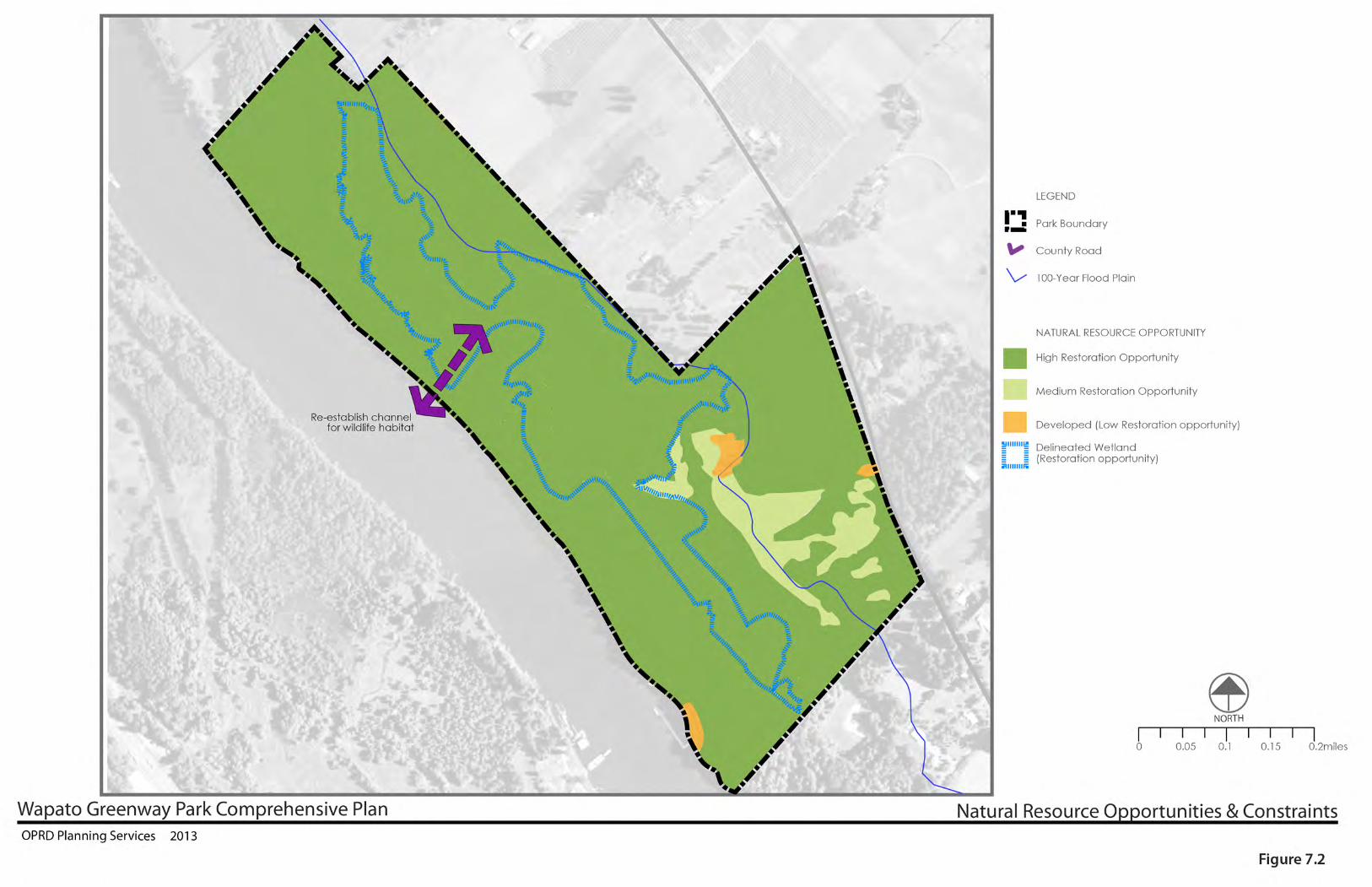


58 Wapato Greenway Comprehensive Plan
Values & Goals8
To become a state natural area, a landscape has to pass over a much higher bar—one set by the ideal qualities Oregonians collectively admire about their natural environment. In this plan, we refer to this collective regard for a particular ideal as a “value.” By asking “Why a park here?”, OPRD has an opportunity to create goals based on big ideas. Park values draw a line in the soft soil; they warn us when we are considering actions that could move us further away from the ideals that set state parks apart from other kinds of landscapes.
Describing those ideals begins by recognizing the agency mission, which shape the principles contained in the Centennial Horizon vision document and the Park System Plan that lays out an approach for managing the parks. These mandates and strategies thereby direct statewide policies for natural resources, recreation, and cultural resources. This process guides us when we draft values specific to Wapato, and in turn those values become goals for the park.
If we accept the concept that natural areas are important to the identity of Oregon, OPRD can best fulfill its role as a land steward by affirming to conserve and restore areas inside the park that will improve the fitness of the landscape. It must design and locate recreation facilities in a way that supports the story telling describing what is important about the park, and pursue strategies and actions that enable recreation activities in what is often referred to as a rural oasis.

Chapter 8: Values and Goals 59
This chapter draws a connection between the Oregon Parks and Recreation Department mission, Centennial Horizon Principles, and policies—statewide guidance discussed in Chapter 5 that affects the entire state park system—and Wapato specific values and goals (Figure 8.1). Chapter 9 takes these park values and goals a step further by converting them into park-wide strategies, services and programs. Chapter 10 divides the park into manageable zones, each with a slightly different mix of natural and recreation priorities. Each zone therefore, has a series of concepts, strategies, and management actions that are tied to the setting and resource needs for that location.
Oregon Parks and Recreation Department MissionProvide and protect outstanding natural, scenic, cultural, historic and recreational sites for the enjoyment and education of present and future generations.
Statewide Principle from Centennial Horizon1. Save Oregon’s Special Places.2. Connect People to Meaningful Outdoor 3. Experiences.4. Take the Long View and Make Parks Last Forever5. Engage People Through Education and Outreach6. Build a State Park System with Vision7. Attract and Inspire Partners8. Prioritize Based on the Vision9. Tend the System with People who Love their
Work
STATEWIDE PARk POLICIES
Natural ResourcesPreserve and protect Oregon’s natural landscape. Manage park properties to enhance the natural ecological processes that sustain natural resources in balance with current and future outdoor recreation interests. Favor biodiversity, reduce ecological fragmentation, and promote native species.
RecreationFoster appreciation and enjoyment of outdoor recreation resources by conserving, developing and maintaining waterways, scenic roads, highway corridors, trails, natural areas and parks.
Cultural ResourcesFoster an understanding and appreciation of the cultural resources entrusted to the agency through research, treatment and interpretation. Consider cultural resource preservation as an intrinsic form of sustainable conservation.
WHy A PARk HERE?
Once a well-kept secret, Wapato Access Greenway, formerly known as Virginia Lake, has grown in popularity in recent years. Oregon State parks has invested in trail improvements, habitat restoration, and interpretive signage. Now its small parking lot provides access to the parks most interesting feature, the seasonal Virginia Lake, which is rich with abundant and extraordinary birds in winter. There are two bird watching viewpoint platforms around the lake, and over 250 species of birds can be seen throughout the year. The importance of this waterbody is underlined by recent efforts to reconnect the wetland with the river and improve habitat for juvenile salmon as well as increasing the vitality of the habitat for all wildlife associated with the park.

60 Wapato Greenway Comprehensive Plan
Value 1 – NatureWe value Wapato as a natural refuge with a focus on water reconnecting Virginia Lake to the Multnomah channel.
Wapato is a fragment of a former large water system providing important habitat, especially fish and birds with connections for wildlife movement in a now enveloped crowded rural setting. The wetland and forest habitat contribute to healthier air, land and water quality in the Metro area.
Goal 1: Maintain and improve Wapato’s contributions to watershed health and habitat diversity, enacting the plan to guide prioritization and articulating actions for managing intact native habitats and restoring habitat conditions where feasible.
Goal 2: Continue to develop the wetland restoration plan for Virginia Lakes, improving hydrological functions, prioritizing viable projects that benefit stream flow, water quality and aquatic habitat.
Goal 3: Maintain and improve priority habitats including remnant patches of Oak savannahs, gallery ash-cottonwood forests, Pacific willow swales, and Columbia sedge meadow that now or potentially support at-risk species. Manage open meadows in locations, sizes and configurations that benefit biological diversity.
Goal 4: Habitat maintenance and restoration will enhance an important resting and feeding area for a stunning variety of wintering waterfowl, as well providing habitat for a wide array of species including Western painted turtles, red-legged frogs, and willow flycatchers.
Goal 5: Restore fish passage with the reconnection of Virginia Lakes to the Multnomah Channel, providing quality refugia for endangered salmonids.
Goal 6: Continue to use best management practices in controlling invasive species. Efforts to manage invasive weeds should focus first on avenues of dispersal and potential threats to higher quality native habitats.

Chapter 8: Values and Goals 61
Value 2: Visitor Experience
We value the Wapato landscape, its natural character, and the enjoyment it brings to the lives of those who experience it. We value outdoor recreation at Wapato and the contribution it provides to a happy, healthy, stress-reducing lifestyle.
Goal 1: Continue offering the majority of existing recreation activities at their current levels, including hiking, exercise, dog walking (on leash), nature observation, and picnicking.
Goal 2: Enhance opportunities for environmental education especially the ongoing restoration of the wetland and birdwatching.
Goal 3: Provide enhanced opportunities for birdwatchers as the park is a significant bird area, where many species can be sighted in a small area.
Goal 4: Implement improvements to key park facilities, circulation, operations and maintenance as needed to support park functions and facilitate efficient and effective management.
Goal 5: Explore ways to improve universal accessibility to the park’s recreational opportunities, and implement related changes that are compatible with the park’s natural resource character.
Goal 6: Implement changes to the park’s trail system as needed to enhance trail experiences, functions and orientation.
Value 3: Traditions
We value the history and experiences at Wapato that have shaped the landscape and our understanding.The stories, traditions and experiences have been a part of the Wapato, Coalca landscapes for thousands of years and these activities that have been enjoyed at Wapato for generations.
Goal 1: Continue Honor the history and traditions of Confederated Tribes of Siletz and Confederate Tribes of the Grand Ronde Community.
Goal 2: Preserve and interpret vegetation and landscape elements traditionally valued by the Confederated Tribes of Siletz and Confederate Tribes of the Grand Ronde Community.

62 Wapato Greenway Comprehensive Plan
Value 4: Community Benefits
We value how the parks can strengthen local communities, improve health, and benefit their economies.
Goal 1: OPRD, Portland Audubon, the West Multnomah Soil and water conservation district, and the Lower Columbia Estuary Project are committed to their partnership that serves to restoration of the wetland.
Goal 2: Continue exploring and implementing strategies for involving members of the community in natural resource stewardship activities especially regarding wetland restoration and enhancement of fish habitat
Goal 3: Continue partnership with Audubon society to promote birding opportunities
Goal 4: Work with Island Academy (island grade school) to create outdoor classroom for Sauvie Island
Goal 5: Engage relationship with fisherman to understand their needs
Goal 6: Expand opportunities for the community to keep a close relationship to the park including volunteer opportunities for invasive removal work parties
Goal 7: Continue efforts to engage with boaters on the best practice for managing the dock
Goal 8 Continue to work with Audubon Society of Portland, Portland Community College and Portland State University on providing field trip site at the park.
Goal 9: Work with island residents on traffic safety and parking issues along the road.

Chapter 8: Values and Goals 63

64 Wapato Greenway Comprehensive Plan
Strategies & Operations9
Park StrateGieS
as covered in Chapter 8, OPrD’s management of Wapato is guided by a set of natural, cultural, recreational, and social values and goals. Protecting these values and goals helps avoid changing the park in an undesirable way. this chapter describes major strategies and guidelines. Natural and cultural resource management strategies are detailed first (since they are the priority), followed by recreation concepts, park management needs, and community partnerships.
the strategies that will shape tryon Creek cover six main categories:
1. Stewardship 2. Visitor experiences 3. Park Programs 4. Park Facilities- 5. Community Outreach6. Sustainability
each of these is described below and provides a summary of intent for how the park will be managed over the coming decade. Based on these concepts and strategies, the following chapter (Chapter 10 Park Management Zones) describes the actions that will fulfill our goals and strategies for the park. Of the six categories, the

Chapter 7: Opportunities and Constraints 65
public has often commented that protecting the natural resources is our most important priority. Without restoration of the wetland and protection of the plants the wildlife will not flourish and the opportunities to recreate in the park will consequently be diminished. the public also stated that recreation opportunities should be limited to a light footprint on the land that complements and does not impair the natural status of this area.
these strategies are enacted throughout the park, they can be organized into a single management zones described in Chapter 10. The management zone ascribes a high level of focus for natural with cultural and recreational strategies a secondary focus.
4 Primary Parkwide Strategies 1. Develop wetland restoration project through
partnership with Portland audubon, the West Multnomah Soil and water conservation district, and the Lower Columbia estuary Project
2. Protect priority native plant communities and wildlife through partnership with local community volunteers, as well as identifying other potential partners
3. Update environmental education programming initiatives to maximize effectiveness and the visitor experience including field classroom, outdoor school and improved media information
4. enhance the parking, trails and day use area to improve orientation, better serve youth groups visiting the park, and ensuring existing visitors get the best facilities to improve their welcome to the park
1. SteWarDShiP StrateGieS
Nature: We value Wapato as a natural refuge with a focus on water reconnecting Virginia Lake to the Multnomah channel.
Wapato is a fragment of a former large water system providing important habitat, especially fish and birds with connections for wildlife movement in a now enveloped crowded rural setting. the wetland and forest habitat contribute to healthier air, land and water quality in the Metro area.
Traditions We value the history and experiences at Wapato that have shaped the landscape and our understanding.
the stories, traditions and experiences have been a part of the Wapato, Coalca landscapes for thousands of years and these activities that have been enjoyed at Wapato for generations.
1.1 enact the plan to guide prioritization for maintaining intact native habitats
1.2: improve Wapato’s contributions to watershed health improving hydrological functions, prioritizing viable projects that benefit stream flow, water quality and aquatic habitat.
1.3 Provide habitat for several sensitive or endangered species including Western painted turtles, red-legged frogs and willow flycatchers as well as nest boxes for purple martins,wood ducks, kestrels, swallows and owls and basking logs for turtles
1.4 Protect and enhance important resting and feeding area for a stunning variety of wintering waterfowl.
1.5:Restore fish passage with the reconnection of Virginia Lakes to the Multnomah Channel, providing quality refugia for endangered salmonids.
1.6 improve priority habitats including remnant patches of Oak savannahs, gallery ash-cottonwood forests, Pacific willow swales, and Columbia sedge
1.7 Manage the open meadows in locations, sizes and configurations that benefit biological diversity.

66 Wapato Greenway Comprehensive Plan
1.8 habitat maintenance and restoration will enhance an important resting and feeding area for a stunning variety of wintering waterfowl, as well providing habitat for a wide array of species including Western painted turtles, red-legged frogs, and willow flycatchers.
1.9 adaptively manage emergent marshland, deciduous forested wetlands, Pacific willow swamps, scrub-shrub wetland, woody debris in waterways
1.10 Manage invasive weeds with a focus first on avenues of dispersal and potential threats to higher quality native habitats including but not limited to reed canary grass, invasive geraniums, garlic mustard, blackberries, and hawthorne trees.
1.11 Minimize wildlife disturbance with enforcement of leash requirement, information signs about problems caused by dogs, and additional viewing blinds.
1.12 Develop Government to Government relationship with Confederated tribes of Siletz and Confederate tribes of the Grand ronde in regards the park
1.13 Create a program the provides education regarding the vegetation and landscape elements traditionally valued by the Confederated tribes of Siletz and Confederate tribes of the Grand ronde.
2. ViSitOr exPeriNCe StrateGieS
We value the Wapato landscape, its natural character, and the enjoyment it brings to the lives of those who experience it. We value outdoor recreation at Wapato and the contribution it provides to a happy, healthy, stress-reducing lifestyle.
2.1 Retain hiking, exercise, dog walking (on leash), nature observation, and picnicking opportunities for the visitor
2.2 Retain 30 minute loop trail around wetland, which provides for an excellent short walk as well as a quick 5 minute walk to picnic area from parking lot (which will provide a view across wetland when restoration project is enactred).
2.3 add to the existing environmental education program providing an ongoing story in regards the restoration of Virginia Lake.
2.4 The park is a significant bird area and enhanced opportunities for birdwatchers will increase enjoyment if carefully located in park as to not disturb wildlife.
2.5 improve universal accessibility to the park’s recreational opportunities especially at the entrance with access to the picnic shelter and adjacent bird watching area
2.6 enhancements to the picnic area will provide for a better resting area, with opportunities to picnic and learn about the landscape

Chapter 7: Opportunities and Constraints 67
2.7 retain access to park for equestrians as an off-road place for people to ride horses.
2.8 Work with boaters to optimize opportunities for a stopping place on the Multnomah Channel with appropriate facilities
2.9 Work with anglers to improve fishing access and associated facilities.
3. Park FaCiLitieS StrateGieS
the park facilities are managed to support and enhance the visitor experience and not impair resources. the facilities at Wapato are minimal befitting the natural landscape.
3.1 improve entrance sequence to take care of parking issues and provide improved orientation to park. also, provide sense of entrance that highlights state park stewardship and blends with setting.
3.2 Provide restroom at park outside of floodplain
3.3 retain existing trail system with minor improvements to enhance visitor experience and improved drainage to increase life cycle of tread
3.4 enhance viewpoints along trail by adding viewing blinds, sitting areas and some learning opportunities that will enhance trail loop experience.
3.5 enhance open area with minor improvement to picnic shelter, add picnic tables, provide learning opportunities and open up views to wetland.
5: CoMMuniTy ouTReaCh StrateGieS
We value how the parks can strengthen local communities, improve health, and benefit their economies.
5.1 oPRD, Portland audubon, the West Multnomah Soil and water conservation district, and the Lower Columbia estuary Project are committed to their partnership that serves to restoration of the wetland in
the park
5.2 Continue exploring strategies for involving members of the community in natural resource stewardship activities including Sauvie island Conservancy and Sauvie island Community association.
5.3 Work with island residents on traffic safety and parking issues along the road. Continue to review speeding, road shoulder parking, killed wildlife and any other issues as they arise.
5.4 engage relationship with fisherman to understand their needs
5.5 Continue efforts to engage with boaters on the best practice for managing a docking location
5.6 Continue partnership with audubon society to promote birding opportunities
5.7 Continue to work with audubon Society of Portland, Portland Community College and Portland State university on providing field trip site at the park 5.8 Work with island academy (island grade school) to develop outdoor classroom for Sauvie island
5.9 Develop learning program at park for adults, children and families with potential to include:
• Bird and Wildlife sighting program including media describing bird and wildlife information. Consider developing Let’s Go Birding program at park
• Develop environmental educational programs focused on wetland restoration
5.10: Consider an adopt-the-Park program to foster relationship with local community including:
• Partnership information can be sent out via Sauvie island Newslinks, Sauvie island academy eNews, Skyline ridgerunner and Linnton newsletters.
• Work publicity and promotion of park as a local destination
• Work together on solutions for noise and general disturbances
• Park staff provide community updates including annual presentation to the Sauvie island Community association and apprise neighbors of changes via an email list Sauvie island website

Chapter 10: Managememt Zones 69
Management Zone10

70 Wapato Greenway Comprehensive Plan
Table 10.1: Combining Opportunity Areas into Management Zones
3
2
Rural
Natural
Natural Natural
2 2
High Natural Restoration OpportunityMedium Natural Restoration Opportunity
DevelopedDelineated Wetland
HIGH MED LOW
Natural R
esources
V
isitor A
ctivitie
s
Cultu
ral R
esources
A
dmin. Progra
ms
Faciliti
es
Wapato Greenway
Wapato GreenwayWapato GreenwayWapato Greenway
OPPORTUNITY AREAS TO MANAGEMENT ZONES
ROS
Descrip
tion
ROS
Settin
g Assi
gned
Management
Zone
Opportunity Areas
Assesment Values Recreation OpportunitySetting
ManagementZones
Managing Our Parks
Our State Park system represents an extremely diverse variety of experiences, landscapes, and resources. The variety of experiences found in Oregon State Parks are what compels visitors to them over and over again since the department was established in 1921. Therefore it is easy to understand why universal park management strategies are complicated to establish across the state. Yet there is a practical need for universal management strategies in operating a statewide agency.
Through investigating the resources that State Parks are mandated to protect within its mission, a parkwide management strategy that is similar across the state, but flexible to the conditions we find on the ground has been developed. Assessments are made across the entire park based on historical, geographical, biological, and cultural surveys to establish the values of a park. As a result, four categories of resources — natural (plants, animals, soils and water), scenic, cultural and recreational — are prioritized in the planning process.
Management Zones within each park are established from these assessments and this chapter describes the priorities for each. Within each management zone, information on strategies, concepts and guidelines are described and management actions are then listed for that portion of the park. Using management zones as a guide, staff can make more informed decisions about how best to assign their time and budget to achieve park goals and realize values. Management zones guide the work to be completed in each area.
Wapato is a relatively small park it will be managed similarly across the greenway. This results in the creation of one single management zone, Wapato Greenway. The zone described in this chapter was created to preserve and improve the park’s most important natural, scenic, recreational and cultural resources.
Park management zones are the next logical step, following the foundation created in Chapter 7 with identifying Opportunities and Constraints, Values and Goals for Park Management in Chapter 8, and Chapter 9 Park Strategies and Operations. The assessments made in the Wapato comprehensive plan represent the efforts for one of the first complete natural resource assessment made for any park planning process.
Five opportunity areas were described in Chapter 7, and each describes natural and recreation priorities in one of three ways: primarily natural, primarily recreational or a mixture of the two. The management zone is based on identifying similar assessment values and recreation opportunity settings across the opportunity areas.

Chapter 10: Managememt Zones 71
resOurce and VisitOr exPerience ManageMent FOcusThe management zones that make up the park define natural resource conservation strategies, recreation intensity, scenic character protection, cultural resource preservation, and operations management. Wapato’s focus prioritizes natural resources with complimentary recreation facilities.
Top 3 Wapato Greenway Management Zone Activities:
1) Bird and Wildlife Viewing & Hiking2) Fishing3) Youth Field Trips
1. WaPatO greenWay ManageMent ZOne
1.0 Wapato greenway Management Zone - resource and Visitor assessment ValuesZone Natural Resources Cultural & Scenic Visitor Experiences Programs Facilities1. Wapato Greenway
High Medium Med Low Low
Image 10.1: Wetland Edge in Winter

72 Wapato Greenway Comprehensive Plan
1.1 NATurAl resourcesSeveral ecological types are present at Wapato Greenway: forest, oak savannah, shrubland, grassland, and wetlands. The restoration of these natural habitats will add to the experience of visiting the park. For locations of these areas please refer to the Comprehensive Management Zone Map (Figure 10.1).
For prescribed restoration actions across the management zone, please refer to Figure 10.2 Restoration Priorities and Prescriptions.
FOREST
GRASSLAND
SHRUBLAND
WETLAND
SAVANNA
DEVELOPED
INVASIVE SPECIES
Alliaria petiolata
Solanum dulcamara
DESIRED CONDITION
DESIRED CONDITION
DESIRED CONDITION
DESIRED CONDITION
DESIRED CONDITION
DESIRED CONDITION
Populus alba
Rubus armeniacus
Rubus armeniacus
Rubus armeniacus
Rubus armeniacus
Rubus armeniacus
Phalaris arundinacea
Phalaris arundinacea
Phalaris arundinacea
Phalaris arundinacea
Phalaris arundinacea
Phalaris arundinacea
Rosa multiflora
Rosa multiflora
Rosa multiflora
Rosa multiflora
Myriophyllum aquaticum
Myriophyllum aquaticum
Myriophyllum aquaticum
Cytisus scopariusIlex aquifolium
Ilex aquifolium
Ilex aquifolium
Acer platanoides
Hedera helixGeranium robertianum
Crataegus monogyna
Crataegus monogyna
Geranium lucidum
Geranium lucidum
Clematis vitalba
meadow, prairie, or savannaColumbia River sedge, tufted hairgrass, hodding beggarticks, meadow barley, mannagrassPacific willow, stinging nettle, jewelweed, rice cutgrass swamp, Oregon ash wet woodland, red-osier dogwood, nootka rose, suksdorf, hawthorn, Pacific crabapple, hardhack shrubland
nodding beggarticks, creeping spikerush, burreed, water plantain, rice cutgrass marshcattail bed, water smartweed, yellow pondlily, wapato, burreed potamogeton
late seral Douglas fir, red elderberry, swordfern forestcottonwood, Oregon ash wet to mesic gallery forestbigleaf maple, grand fir, hazel, indian plum,Oregon white oak mesic forest or woodland, nootka rose, suksdorf hawthorn
crabapple, red-osier dogwood, hardhack shrublandOregon ash, cottonwood, Pacific willow, nootka rose, suksdorf hawthorne, stinging nettle, jewelweed, rice, cutgrass swamp, red elderberry, hazel, swordfern, ladyfern, shrubland
Oregon white oak savanna
Table 10.2: Desired Natural Resource Conditions

Chapter 10: Managememt Zones 73
1.3 Wapato greenway Management Zone - Visitor experiencesDescription Status
Outdoor Recreation
Bird or Wildlife Watching Retain
Dog Walking Retain
Hiking/Walking Retain
Native Plant Observation Retain
Picnicking/BBQ Retain
Photography Retain
Environmental Education
Youth Field Trips Retain
Interpretation
Ranger Led Programs Retain
Self-Guided Activities (Bird Identification) Retain
Panels New
Volunteers/Partners
Adopt-A-Plot Retain
Environmental Literacy Program Retain
Volunteer Invasive Plant & Ivy removal Retain
Volunteer Trail Maintenance Retain
Wildlife Sighting Program New
Bird Nesting Enhancement New
Events
Scenic Resources
Bird Blind Locations (existing and proposed) State Scenic Review, Possible Federal Wild and Scenic review
Oak Savannah State Scenic Review, Possible Federal Wild and Scenic review
Wetland State Scenic Review, Possible Federal Wild and Scenic review
1.2 culTurAl resourcesThe potential for archaeological sites to be found across Wapato Greenway is high based on archaeological surveys described in Chapter 3. Given that the park is located on Sauvie Island, an area known to have been frequented by a large population of native tribes, it is possible that Native American archaeological resources are present across the entire park boundary and any development project should consult an archeologist.
1.3 VisiTor experieNces
Typical visitor experiences at Wapato involve fishing, hiking, or viewing wildlife from one of the trails. These activities will not be expanded, as Wapato is primarily a natural area. New interpretive and outdoor educational experiences will be added to enrich the outdoor experience, while not interfering with the natural character of the greenway. Providing an understanding of the restoration efforts and habitat quality to visitors is part of ensuring lasting quality of the natural conditions. Additional volunteer opportunities, especially involving invasive removal and restoration plantings will continue to be encouraged.

74 Wapato Greenway Comprehensive Plan
1.4 AdMiNisTrATiVe proGrAMsDay to day administrative activities for Wapato are as follows:
1.4 Wapato greenway Management Zone - administrative ProgramsFocus Description
Nat. Res. Manage weeds as prescribed in Natural Resource Management Plan, including manual and chemical treatments followed by planting of native or interim species, especially along trails. Continue implementing natural restoration strategies focusing on riparian areas and sites impacted by invasive species and stormwater. Manage partnerships with volunteers.
Cul. Res. Protect known cultural and archaeological resources. Participate in agency provided training. Ensure all projects adhere to cultural clearance request process. Facilitate further professional monitoring and surveying of park land for better identification and inventorying of resources. Conduct park activities and interpretation in a manner that furthers these goals and prevents adverse impacts.
Vis. Exp. While occasional, interpretation will be used by staff when encountering visitors in this management zone to educate on safety and reducing impacts on the land.
Scen.Res. Preserve viewsheds and additional viewing opportunities for viewing access.
Fac. Maintain park amenities to Oregon Parks and Recreation Department standards, using a park specific Maintenance Management Plan and HUB. Amenities include but are not limited to day use area, picnic facilities, restrooms, landscaping, fence, signs, trails, potable water system, septic system.
Fac. Develop trails to protect natural resources from visitor impacts while providing trail connectivity and scenic viewing opportunities.
Fac. Maintain trails to Oregon Parks and Recreation Department standards to ensure safety and prevent erosion.
Fac. Develop roads to provide safe visitor access while protecting natural resources and complying with scenic requirements.
Fac. Maintain roads to Oregon Parks and Recreation Department standards to ensure safety and prevent erosion
Man. Operate potable water and septic systems, including required testing, in compliance with state law and Oregon Parks and Recreation Department standards and policies. Provide necessary services while ensuring visitor safety and legal compliance.
Man. Periodically patrol for rule enforcement and safety including boundary monitoring for encroachment.
Man. Work with government partners to establish a park emergency plan. Staff training should include fire prevention, visitor education, evacuation procedures and thorough familiarity with the park emergency plan.
Man. Coordinate with agencies that execute projects within the management zone boundary.
Image 10.2: Boardwalk

Chapter 10: Managememt Zones 75
1.5 FAciliTiesThe Management Area map highlights a few small facility improvements proposed for Wapato. This would include the development of a small trail where fishermen often tread to access the fishing dock. There is the potential for a third small bird viewing platform on the northern edge of the wetland. The picnic shelter will be replaced or structurally upgraded to meet safety standards. An interpretive element would also be integrated into the shelter’s frame to allow school groups and recreational visitors to learn a little about the restoration process occurring on the wetland and the process of removing invasives and restoring the oak savanna. This effort would also open the view from the picnic shelter area to the wetland as well. Two sites for benches have also been sited along the main loop trail.
Oriented to frame particular views onto the river and into the wetland these will allow visitors a place to pause and take in the site. The parking lot will be set back 50’ from the center line of the road for a safer entry and exit. A trail kiosk and small sign will also be added to this area for orientation purposes. A CXT restroom will be constructed at the intersection of the loop and fishermen’s trails for fishermen, school groups, and other recreational park users. It will be located far enough away from the road to dissuade most passing drivers on the Sauvie Island Road from simply parking and using the facility. Each of these site improvements will provide small enhancements to this well-loved daily destination for many Sauvie Island residents. It is our mission to balance the flow of visitors and recreation enthusiasts with efforts for restoring and preserving the existing natural elements.
For locations of these enhancements, please refer to Figure 10.1 Comprehensive Management Zone Map.
ÁÁÁ
OPR
D Park Boundary
Sauvie Island Road
Entrance Trail
To Wildlife
AreaFence around Parking
Large Rocks
Bollard
SmallGathering
Area
Multnom
ah County R
.O.W
. (50')
30' Setback Line NewEntrance
Sign
Save large Cottonwood Trees
30'20'
0 25 5012.5Feet
Day Use ParkingWapato Greenway Property ±
Bike Parking
23 Parking Spaces (2 ADA)
Restoration Planting Around Parking Edges
Figure 10.3: Day Use Parking Area Design
ÁÁÁ
OPR
D Park Boundary
Sauvie Island Road
Entrance Trail
To Wildlife
AreaFence around Parking
Large Rocks
Bollard
SmallGathering
Area
Multnom
ah County R
.O.W
. (50')
30' Setback Line NewEntrance
Sign
Save large Cottonwood Trees
30'
0 25 5012.5Feet
Day Use ParkingWapato Greenway Property ±

76 Wapato Greenway Comprehensive Plan
1.5 Wapato greenway Management Zone - FacilitiesDescription Status Size/
QuantityReviews / Approvals
Cost Funding Source
Hub ID
Day Use Parking Area Enhancements (Figure 10.3)
Main Entrance
Intersection Maintenance: Cyclical
1 ea Mult. County; ROW jurisdiction
TBA
Exterior Park Sign New 1 ea Mult. County; ROW jurisdiction
$20,000 TBA
Circulation: Roads and Parking
Includes roadway from entrance and parking areas
Colored Asphalt road - 20 ‘ wide New 40 lf Mult. County Road/street jurisdiction & DEQ
$4,600 TBA
Main Parking lot (incl walks, stalls, road) Rehab 3,725 sf Mult. County Road/street jurisdiction & DEQ
$22,350 TBA
Parking lot landscaping and bio-swales New 1,550 sf Mult. County DEQ
$3,700 TBA
Signage, markings New 1 ea Mult. County Road/street jurisdiction
$10,000 TBA
Gates New 1 ea Mult. County Road/street jurisdiction
$3,000 TBA
Gates Maintenance: Cyclical
1 ea Mult. County Road/street jurisdiction
$1,200 TBA
Sitework
Interpretive signage kiosks New 1 ea Mult. County $3,000 TBA
Wayfinding signage New 2 ea Mult. County $840 TBA
Wood Fencing New 440 lf Mult. County $26,400 TBA
Lighting New 2 ea Mult. County $8000 TBA
Day use area trees New 10 ea Mult. County $2,500 TBA
Day use area landscape irrigation (includes controllers) New 1,550 sf Mult. County $1,500 TBA
Benches (includes benches in 5 Seating Areas) New 2 ea Mult. County $2,000 TBA
Utilities
Well and water pipes Mult. County n/a TBA
Domestic well water treatment structure 1 ea Mult. County n/a TBA
Electrical connections Maintenance: Cyclical
1 ea Mult. County n/a TBA

Chapter 10: Managememt Zones 77
Circulation: Trails
Core Paths - 3’ wide: dirt New 400 lf Mult. County $3,600 TBA
Core Paths - 3’ wide: dirt Maintenance: Cyclical
12,459 lf Mult. County n/a TBA
Buildings, Structures and Major Features
Channel New 1 ea Mult. County DEQ, Oregon Fish and Wildlife, ACOE
n/a TBA
Bridge Over Channel New 1 ea Mult. County DEQ, Oregon Fish and Wildlife, ACOE
n/a TBA
Picnic/Shade Structure New 1 ea Mult. County $20,000 TBA
Picnic tables (for Shade Structures) New 6 ea Mult. County $1,200 TBA
Sitework
Composting Toilet (constuction - 200 sf) New 1 ea Mult. County $100,000 TBA
Nature Viewing Deck Maintenance: Cyclical
800 sf Mult. County DEQ n/a TBA
Bird Blind New 1 ea Mult. County DEQ $10,000 TBA
Bird Blind Maintenance: Cyclical
128 sf Mult. County DEQ n/a TBA
Boardwalk Maintenance: Cyclical
1 ea Mult. County DEQ n/a TBA
Boardwalk (over southern Berm Enhancement) New 1 ea Mult. County DEQ $1,000
Interpretive panels Maintenance: Cyclical
3 ea Mult. County n/a TBA
Interpretive panels New 6 ea Mult. County $1,000 TBA
Drinking Fountains New 1 ea Mult. County DEQ $3,000 TBA
Hadley’s Landing Picnic/Day Use Area
Sitework
Boat Dock Maintenance: Cyclical
1 ea Mult. County DEQ, Oregon Fish and Wildlife, ACOE
$10,000 TBA
Picnic tables (for Shade Structures) Maintenance: Cyclical
3 ea Mult. County n/a TBA
Fire Rings Maintenance: Cyclical
3 ea Mult. County n/a TBA

78 Wapato Greenway Comprehensive Plan


Chapter 5: t 81
Reviews and Approvals11Land Use aUthority
development of the park uses and facilities described in this Plan for Wapato Greenway is governed by Multnomah County under the provisions of the County’s Comprehensive Land Use Plan. the County Plan is acknowledged by the Land Conservation and development Commission (LCdC) pursuant to the statewide land use goals, statutes and related administrative rules.
this Plan for Wapato has been formulated through the planning process described under oar 736 division 18 and oar 660 division 34. the planning process includes procedures for coordinating with affected local governments to assure that planned park uses and facilities are compatible with local government comprehensive plans.

82 Wapato Greenway Comprehensive Plan
Land Use CoMPatibiLity revieW
Prior to oPrd’s adoption of a plan for a state park property, review of the park plan for compatibility with the affected local government comprehensive plan is required. When a draft park plan is ready for oPrd’s adoption, oPrd requests that the local planning official provide written confirmation that the draft park plan is compatible with the local comprehensive plan. “Compatible” means that development permits may be approved for all of the planned park projects without first amending the local government’s comprehensive plan, or that the plan for the park specifically states that a local plan amendment will be needed prior to construction of any project that is not compatible. alternatively, if the draft park plan is determined to be incompatible, the park plan may need to be changed to achieve compatibility before it is adopted. the Plan for Wapato Greenway will be reviewed for local land use compatibility by Multnomah County planning officials.
MULtnoMah CoUnty ZoninG
Wapato Greenway falls entirely within the exclusive Farm Use (eFU) Zone. additionally, there are three overlay zones that apply to the property, the Willamette river Greenway, Flood hazard and Wetland overlays. the Willamette Greenway overlay applies to the entire park. the Flood hazard overlay applies to areas shown as 100-year floodplain mapped by FeMa, which includes most of the park, the existing picnic shelter, most or all of the existing trail, the trail bridge and the dock. Identified wetlands, most or all of which are within the 100-year floodplain, are
covered by the Wetland overlay. this overlay includes a 50’ buffer between wetland boundary and upland activity (Multnomah County sauvie island/Multnomah Channel rural Plan area 34.5865).
all of the existing and planned park uses and facilities are allowable under current zoning, subject to the County’s applicable approval criteria and development standards. however, as discussed below, Wapato’s existing uses and facilities were never authorized through County land use permits required at the time they were put in place. no further development in the park will be allowed until the existing uses and facilities are brought into compliance through retroactive permitting.
voLUntary CoMPLianCe aGreeMent
Compliance with County land use regulations for existing park uses and facilities must be achieved before the new improvements proposed in this Plan for the park can be approved. oPrd has entered into a voluntary Compliance agreement with the County in order achieve compliance in conjunction with the County’s review of the park plan for land use compatibility. the agreement sets out the permitting requirements for the pre-existing park uses and the associated land use application schedule. the agreement is included in Chapter 3 of this plan and referenced in the appendices Chapter.
deveLoPMent PerMits For state Park ProjeCts
development permits will be required for most of the development projects described in the plan for the park. Prior to beginning construction of any project, the project manager is responsible for consulting with the affected local government planning department and obtaining the necessary development permits. The specific requirements for obtaining development permits for a project, and the kind of local permitting process required will vary from one project to another. the time required for completing the development permitting process will also vary, so the project manager should consult with the local government planning department early enough to assure the

Chapter 5: t 83
permitting process is completed prior to the target date for beginning construction. Prior to issuance of development permits the local government will review the project plans and specifications to assure the project proposed for construction is consistent with the description of the project in the park plan and with any applicable development standards in the local government’s ordinances.
variations FroM the Master PLan
Under the provisions of oar 736-018-0040, oPrd may pursue development permits for a state park project that varies from a state park plan without first amending the park plan provided that the variation is minor, unless the park plan language specifically precludes such variation. Any specific project design elements that cannot be changed by applying the “Minor variation” rule are indicated in the design standards for the projects in the plan.
the oPrd director must determine that a proposed variation from the master plan is “minor” using the criteria in oar 736-018-0040. a minor variation from the master plan, which is approved by the director, is considered to be consistent with the master plan, contingent upon the concurrence of the affected local government.
rehabiLitation oF existinG state Park Uses
state laws allow oPrd to continue any state park use or facility that existed on july 25, 1997. (see ors 195.125 and oar 660-034-0030(8).) the laws allow the repair and renovation of facilities, the replacement of facilities including minor location changes, and the minor expansion of uses and facilities. rehabilitation projects are allowed whether or not they are described in a state park plan. these projects are subject to any clear and objective siting standards required by the affected local government, provided that such standards do not preclude the projects.

84 Wapato Greenway Comprehensive Plan
Prior to applying for development permits for a project involving a minor location change of an existing facility or minor expansion of an existing use or facility, the oPrd director must determine that the location change or expansion is “minor” using the criteria in oar 736-018-0043. a determination by the director that a proposed location change or expansion is minor is contingent upon the concurrence of the affected local government.
natUraL resoUrCe revieW and aPProvaLs
oPrd staff in consultation and coordination with local, state, and federal agencies and partners has determined the need for natural resource stabilization and restoration. Under the authority of oPrd Commission Policy 20-0 natural resource, and oP 50-09 invasive species Management, natural resource projects will be undertaken to manage and restore the landscape to benefit the local resources. OPRD staff work with local partners such as watershed councils, soil and water conservation districts, and surrounding land owners to implement specific resource projects. Projects are developed and implemented by park management, as budget and staff allow.
CULtUraL resoUrCe revieW and aPProvaLs
oPrd recognizes that the preservation and protection of cultural resources is an important aspect of land management. Management of historic and archeological resources is in accordance with oPrd Commission Policy 20-02. oPrd has worked with tribal interests and local heritage organizations to identify how proposed park development may affect cultural resources. oPrd works with the state historic Preservation Office to secure approval for any project that may have impacts on cultural resources. oPrd will continue to work with tribal and local interests to ensure any significant cultural resources of Wapato Greenway are preserved and protected.
eMerGenCy ManaGeMent
oPrd strives to provide a recreation experience that is safe for staff, visitors, and the surrounding community. the life-safety aspects of facility and infrastructure development are reviewed during the local government land use permitting process. oPrd has additional responsibility beyond the local planning jurisdictions. Park management is responsible for the development of an emergency management plan under oPrd policy 70-04. the development of this emergency management plan will occur after land use review of the park plan has been completed. development of the emergency management plan is done through consultation and coordination with affected emergency service providers.

85
Appendices12
Appendix A: Supporting documentS And reportS
oprd Background reports and documents:• oregon natural Areas plan, oprd, Salem, 2010• State park System plan, oprd, Salem, 2012• Wapato Access Wildlife Assessment, orpd,
december 2011• Vegetation inventory and Botanical resource
Assessment for the Wapato Access Willamette river greenway property, orpd, november 2011
• tryon creek management unit master plan cultural resources overview, oprd, Salem, 2011
• Wapato Access Willamette river greenway drAFt interpretive Assessment, oprd, Salem, 2013
• environmental management System Stainability toolbox: A guide to implementing Sustainable principles and the environmental management System at Park and Office locations, OPRD, Salem, 2005
• Scorp regional recreation Survey, oprd, Salem, 2012
• centennial Horizon Vision, oprd, Salem, 2009• oprd HuB database, 2013• the imAp potential natural Vegetation model;• natural vegetation associations reported in natural
resources conservation Service’s nASiS soils data.
The above documents are available for viewing at:oregon parks and recreation departmentNorth Mall Office Building725 Summer Street ne, Suite cSalem, or 97301
Appendix B: oprd StAteWide nAturAl reSourceS policieS & oBjectiVeS
OPRD Natural Resource Policy
As stewards of the natural resources entrusted to the oregon parks and recreation commission, it shall be the policy of oregon parks and recreation department to:
• proactively manage the natural resource base for its contribution to the regional landscape, as well as, its function within a site specific planned landscape.
• Actively cooperate and communicate with our public and private neighbors to promote compatible programs and practices.
• Inform, involve and educate the public in significant planned management actions, including the scientific and practical aspects of current management techniques and strategies.
• Consider the significant ecological, recreational and aesthetic qualities of our resources to be the highest priority.
• develop and follow management programs

86 tryon creek State natural Area comprehensive plan
throw, landslide or flooding; determine what management actions are needed, if any, to attain a desired ecosystem condition or type.
2. Where appropriate, restore or enhance existing low quality resource areas to a higher quality or desired ecosystem types or conditions based on consultation with natural resource agencies as to what a desired ecosystem should be for the planning area and for the region. identify areas of low resource significance to consider for future recreational use and development, as identified in the park master plan.
3. manage all oprd properties to protect existing occurrences of state or federally listed or candidate species to the approval of jurisdictional agencies:
a. integrate species management plans into ecosystem management plans that include the monitoring and management of indicator species.
b. For selected lands, in consultation with natural resource regulatory agencies, determine how best to manage for protected species recovery and related desired ecosystem types and conditions.
4. manage all oprd lands and uses to minimize erosion, sedimentation, and other impacts on important resources.
5. identify and acquire additional lands from willing landowners, or enter into management partnerships with landowners, to provide long term viability for important natural resources within oprd-managed properties, as needed. consider connectivity of resources across properties.
6. in areas of high quality ecosystems or habitats, endeavor to provide opportunities for the public to experience the following:
a. Sights, sounds, smells and feeling of ecosystems representative of oregon and the region;
b. understanding of the ecosystem structure, composition and function;
c. larger views of the landscape of which the ecosystem is a part.
7. in selected areas of low quality natural resources, manage for:
a. popular or attractive native plants or animals
and action plans which exemplify excellence in resource stewardship, fulfill the agency mission, are guided by the management intent of our property classification system and meet or exceed federal, state and local laws and regulations.
Statewide Natural Resource Management Objectives
oprd’s natural resource management guidelines for state parks are based on system-wide objectives, on the mapping of natural resource conditions in the park, and on ecosystem patterns. A summary of the natural resource conditions in the planning area is included in chapter 3, park resource Assessments. detailed resource maps for the park are available for viewing at the oprd Salem headquarters office and the Regional State Park office in Bend.
the following objectives have been established by oprd to guide natural resource management decisions for oprd’s properties statewide. these statewide objectives were considered in combination with the particular resource conditions at cottonwood canyon State park to determine specific objectives for the park. The statewide objectives are listed below:
1. protect all existing high value, healthy, native oregon ecosystems found within oprd-managed properties. (Based on oregon natural Heritage ecosystem types and OPRD definition of high quality.)
a. Allow successional processes to proceed without intervention except as may be needed in particular circumstances.
b. identify and monitor existing high quality ecosystems for the presence of threats to desired ecosystem types or conditions. determine whether there are changes desired in ecosystem types or conditions based on consultation with oregon department of Fish and Wildlife, the oregon natural Heritage information center, the oregon department of Agriculture protected plants section, natural resource interest groups and any affected federal resource management agencies.
c. manage the resources to eliminate any unacceptable threats or to attain desired ecosystem conditions and types.
d. Following a natural or human-caused catastrophic event, such as a major fire, wind

chapter 13: Appendices 87
that are appropriate to the local ecosystem;b. desired views or settings;c. desired cultural landscape restorations for
interpretation.
8. locate, design and construct facilities that provide public access to high quality ecosystems or habitats in a manner that avoids significant impacts on the ecosystems.
9. For those oprd properties or sites which are historically significant and which have been identified by the Department as priority sites for emphasizing cultural resource protection, management and interpretation, manage the natural resources in the cultural resource areas to support cultural resource interpretation, unless this would result in unacceptable conflicts with protected species or areas of special natural resource concern.
10. manage oprd natural resources to protect visitors, staff, facilities and neighboring properties from harm.
11. manage oprd natural resources to protect them from threats from adjacent or nearby properties or their use.
12. limit the use of non-native plants to developed facility areas or intensive use areas, and as is needed to withstand intensive use and to provide desired amenities such as shade, wind breaks, etc. Wherever possible, use native species in landscaping developed sites.
Appendix c: mASter plAn VAriAtionS And AmendmentS
once the park master plan is adopted as a state rule, any development in the park must be consistent with the master plan. minor variations from the adopted master plan may be allowed if such variations are determined by the oprd director and the affected local government to be consistent with the master plan in accordance with oAr 736-018-0040. Any use that is not consistent with the master plan requires a master plan amendment. master plan amendments must follow the same process used to adopt the master plan, which includes re-adoption as a state rule and a determination of compatibility with local government comprehensive plans.
park master plans are amended when changes in circumstances are significant enough to warrant plan changes. the oprd director considers the recommendations of oprd staff and outside interests in prioritizing the park master plans to be adopted or amended each biennium. the director’s decisions are based on considerations of various factors, such as:
• recreation demands that affect the park, and opportunities in the park to help meet the demands;
• The need for significant changes in park uses or facilities to improve park functions;
• Significant changes in the conditions of, or threats to, natural, cultural or scenic resources within or surrounding that park where a master plan amendment is needed to address the changed conditions or threats;
• Conflicts or potential conflicts between park uses and neighboring land uses where a master plan amendment is needed to address the conflicts;
• opportunities to establish partnerships to implement previously unplanned projects that fit the park setting; or
• Alternatives to amending the master plan that would adequately address needed changes, such as interagency management agreements, partnerships, and so forth.
Appendix d: HiStoric VegetAtion modelS And SourceS
Historic vegetation information or modeling available for cottonwood canyon:• the 2008 gAp analysis project;
• the imAp potential natural Vegetation model;
• natural vegetation associations reported in natural resources conservation Service’s nASiS soils data.

88 tryon creek State natural Area comprehensive plan
Appendix e: reFerenceS
Chapter 2: Bishop, ellen morris. in Search of Ancient oregon: A geological and natural History. portland, or.: timber, 2003. print.
Chapter 3:Bowman, j., n. cappuccino, and l. Fahrig. 2002. patch size and population density: the effect of immigration behavior. conservation ecology 6(1): 9. [online] url: http://www.consecol.org/vol6/iss1/art9/
tasa, guy l., julia A. Knowles, marissa A.guenther, and christopher l. ruiz 2007 Archaeological resource evaluation of Area 2, oregon State parks, 2006 Surveys. university of oregon museum of natural and cultural History, OSMA Report 2007-050. On file at the Oregon State Historic Preservation Office. Salem, Oregon.