walk 1. ‘around ulgham manor’
TRANSCRIPT
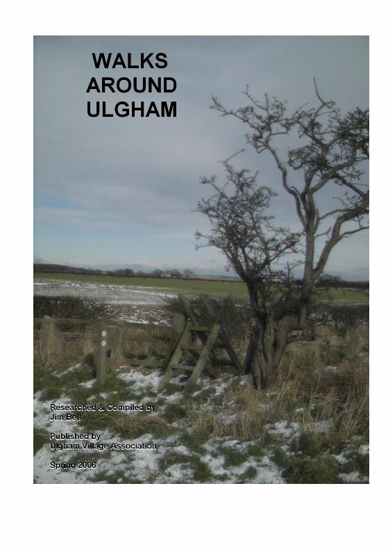
Walk 1. ‘Around Ulgham Manor’
About 2 miles (a leisurely hour) along field paths and lanes
returning to the village along Ulgham Lane.
Mostly very easy, level walking but with some sloping pasture
and a mercifully short section of bog and very muddy banks—in
Spring the primroses are more than compensation.
From the Cross go East along the B1337 and then along the front
of Manor Farm Cottages. Turn right on to the track to Manor
Farm & follow it until it turns sharp right. Here, continue straight
ahead to the stile.
Cross the stile and follow the top edge of the sloping pasture to
the next stile.
Across this stile is a usually very boggy bank leading to a
footbridge. Cross the bridge and climb the (usually muddy) bank
to the stile.
*Over this stile turn right (West) and follow the edge of Hill’s
Wood to the track to Manor Farm. (A private road). Cross this
track and follow the field edge—with the stream and hedge on
your right until you reach the next stile.
Over this stile and straight on until you gain Ulgham Lane by a
plank bridge.
Follow Ulgham Lane Back to the village.
Walk 2. ‘Ulgham Meadows and Ulgham Grange’
A choice of routes covering 2 - 3 miles through and around the
River Lyne valley. Allow up to two hours to fully enjoy your
surroundings & to give the chance to see the wildlife
Easy walking on minor roads and generally well maintained
footpaths. This walk can be extended East towards North Linton
or to the North to Widdrington and the coast.
Go East to the Church (via the bridle road through Manor Farm)
and then to the junction with the road to Ulgham Grange.
Cross the stile and descend the steepish bank to the footpath
through the Meadows. Follow this path to the footbridge over the
Lyne, cross and continue to Birchbeck Cottages. Go along the
back of the cottages, through the field gate then diagonally
(roughly South East) across & up the field to the top boundary.
Follow this on your left to the railway.
Cross WITH CARE; go straight on & cross the stile at the field
boundary; turn right and descend to the next stile, crossing this
takes you through a copse to a footbridge. Go over the bridge
and up a steep wooded bank into a plantation. On the South
boundary of this is a path which leads (East) to South Linton or
West back over the railway & along the top of the pasture to join
the last part of walk 1 at Hills Wood. *
Walks 3a, 3b. ‘Towards Ulgham Park’
Stobswood opencast mine renders much of Ulgham Park
inaccessible. These walks, on roads and well defined paths to the
North of Ulgham, give open views of the village and surrounding
countryside.
Walk 3a is about two & a half miles (an hour & a half or so). 3b is
shorter and easier in that there is less rough walking and the
main road is avoided.
Both Walks
Start at Ulgham Cross. Follow the main road West for about 100
metres and then turn right down the lane towards Ulgham Park.
Cross the River Lyne by the ford (or the footbridge if it is in
spate—remember Archie the postman!) and then go over the stile
into the meadow. The route goes straight up the meadow,
passing the spring on your right to the stile leading into the
plantation.
A straightforward path up through the plantation leads to another
stile. Cross this and continue along the field boundaries to the
next stile. Here the routes diverge.
Walk 3a
Turns left and follows the rough grass path to the Park road
(about 150 metres).
Turn left and then follow the lane back over the ford and up to the
village.
Walk 3b
Turn right after crossing the stile and walk the rough grass path
East to the B1337.
This next section requires care—be aware of fast road traffic
on the narrow road.
Turn right down the main road into the dip where it crosses the
river, then up towards the village.
At the Ulgham Grange lane junction one could cross the stile and
join Walk 2 through Ulgham Meadows.
These two walks might at first sight to be thought lacking in
appeal. But I have watched a Hen Harrier quartering the pasture
SW of Ulgham Park farm, seen myriad multicoloured dragonflies
dancing over a flooded ditch and –always– marvelled at the
changing natural and man-made patterns in the landscape.
Walks 4a & 4b—’Ulgham Broom and beyond’
Walks 4a & 4b are in the South West quadrant of the ‘Ulgham
celtic cross’ and give quite easy, level walking along field margins
and quiet lanes.
4a is about one and three quarter miles (3/4 hour to an hour).
4b is about twice the length of 4a and should take about an hour
and a half.
Both walks leave the Cross and go West along the main road to
the very last house on the South side of the road (Rowan Tree
Cottage).
Cross the stile and follow the path along the field edge: South
then turning East to the next stile on your right.
Cross this and the little bridge. Here walks 4a & 4b separate.
Walk 4a
Turns left over the bridge, crosses the stile & follows the field
boundary (on the left) to the ladder stile giving on to Ulgham
Lane.
Follow Ulgham Lane Back to the village. Or go the opposite way
(East.) and follow walk 1 –or if you have the time & energy—walk
2 in ‘reverse’.
Walk 4b
Carries straight on South from the bifurcation, crossing the ladder
stile in the field’s far corner into and across the corner of a sheep
pasture right by Ulgham Broom farm.
Another stile leads into the next field. A clear path crosses this
arable land to a stile at the far side where a few yards of rough
grass border the haul road.
Cross directly over the road and take the path through the gorse
to a stile which literally tips one on to a plank bridge. This is
Ulgham Parish boundary.
Continue South to the next field corner where one meets a bridle
road at right angles. To the right—about 250 metres is the B1337
(bus route & shorter, more hazardous way back).
Walk 4b goes left, along an ancient avenue and through birch &
hazel thickets into Dukes Coverts /North Plantation (where the
going can be VERY wet—but where deer and badger can
sometimes be encountered) and straight on to meet Ulgham
Lane between Badgers Burn and Crowden Hill nursery.
A left turn and about 30 minutes walk along Ulgham Lane will
bring one back to the village.
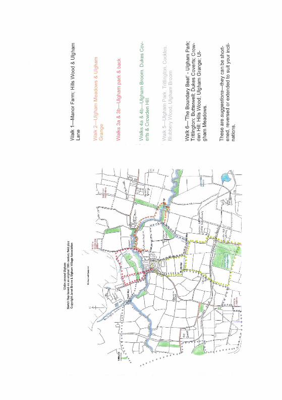
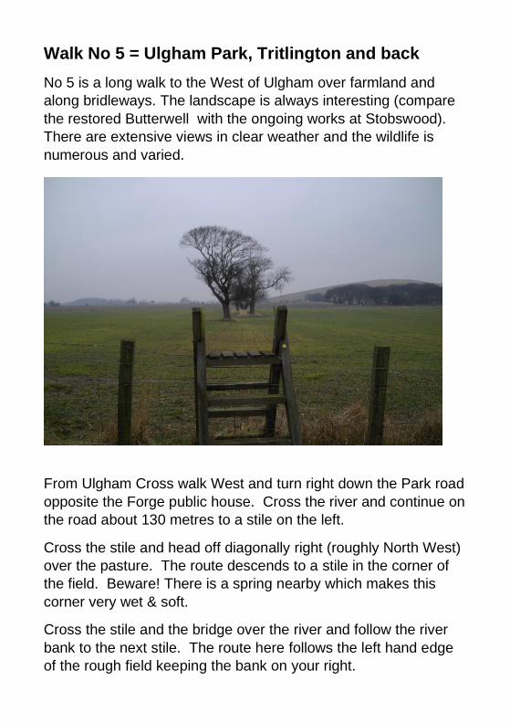
Walk No 5 = Ulgham Park, Tritlington and back
No 5 is a long walk to the West of Ulgham over farmland and
along bridleways. The landscape is always interesting (compare
the restored Butterwell with the ongoing works at Stobswood).
There are extensive views in clear weather and the wildlife is
numerous and varied.
From Ulgham Cross walk West and turn right down the Park road
opposite the Forge public house. Cross the river and continue on
the road about 130 metres to a stile on the left.
Cross the stile and head off diagonally right (roughly North West)
over the pasture. The route descends to a stile in the corner of
the field. Beware! There is a spring nearby which makes this
corner very wet & soft.
Cross the stile and the bridge over the river and follow the river
bank to the next stile. The route here follows the left hand edge
of the rough field keeping the bank on your right.
The next stile is shown above—it gives on to a straight walk
across cultivated land and the opencast haul road to the outskirts
of Tritlington village.
From near the junction of the farm track & the metalled road, walk
5 follows the footpath South East and then South uphill to the
main road West of the haul road overpass. Turn left along the
road for about 1/4 mile then take the bridle road on the right
(parallel to the haul road). This is the half way point & the walk
can be shortened by walking the road direct past ‘The Cockles’ &
down to the B1337.
However—to continue—go along the bridle road along the side of
Blackdean Wood, the gem of a pond with its wildfowl and through
the East part of Blubbery Wood (noted for tears? or blueberries?).
Pass the monstrous remains of the Butterwell opencast buildings
on the right and walk the straight bridleway downhill towards
Longhirst. A field’s width short of the B1337 the route turns
sharply North for about 1/3 mile before jinking right to meet the
road.
This is a second opportunity of a shorter way back—walk the
road (carefully). The 518 will probably stop if signalled ‘
To follow this route to the (surely sweet?) end, leave the main
road after about 200 yards and walk the bridle road East towards
Dukes Coverts. Immediately after the first field boundary, turn left
along the field edge, cross the footbridge & stile, then the gorse
thicket, then the haul road, another stile, the diagonal path across
the field next to Ulgham Broom farm. Two more stiles show the
obvious way North along the field boundary (you are now walking
route 4b)
There is another choice at the next corner—right & over the stile
takes you to Ulgham Lane (10 minutes back to the village).
Straight on over the little bridge & the stile gives about a 15
minute walk along field boundaries to Rowan Tree Cottage at the
very West end of Ulgham.
About 6 miles of quite easy walking took this writer about 4 hours.
Except in rain or the thickest of weather the views alone are
worth the effort & there are delights great & small in the flora &
fauna.
Walk 6 = ‘Beating the Bounds’
This circular walk combines parts of most of the other walks into
a route which follows the boundary of Ulgham parish as closely
as possible.
The total distance is about 10 miles—allow a full daylight day—
pick a fine one! Take a picnic & your time. Arrange to meet
supporters with sustenance & encouragement. Youngsters of any
age might think of racing or sponsorship in aid of a good cause?
Suggested anticlockwise route
Starting from the Cross follow walk No. 5 across the Park Road
ford, along the Lyne / Bailiffs Letch to Tritlington, the Cockles
Road, Blubbery Wood and the B1337 to the bridle road leading to
Dukes Coverts / North Plantation.
Continue (now on walk 4b) to Ulgham Lane, turning left & back
towards the village. At the 2nd sharp bend, walk No 1 goes off
right over the plank bridge—follow it to the East corner of Hills
Wood, cross the stile and turn sharp right along the top of the
pasture and on to the railway (now on walk No 2). Cross with
care and continue through the plantation, down the steep bank to
the bridge, up the other side and back to the railway.
Carefully over the East Coast Main line then onward to
Birchbeck Cottages and Ulgham Meadows—still on route 2 as far
as the stile at the Grange road junction.
Walk the B1337 Northwards into the dip, over the river and up to
the top of the hill, now following route 3a along the South edge of
the opencast site, turning left at the stile to go across two fields,
through the plantation, down the meadow to the ford and then the
final climb up to the village where I always feel a diversion to the
‘Forge’ is justified.
Some thoughts for the future
When Stobswood open cast is finished—whatever the final form of
the restoration takes—there will be more public rights of way to the
North of the village. The original planning consent shows the
former Ulgham Park road to be restored as part of a bridleway
linking Ulgham, Stobswood & Tritlington.
Will the redundant haul road present any opportunities?
Work is in progress (Spring 2006) to extend the footpaths in the
Meadows into a circular walk along both river banks. There is talk
of making a path to link the Meadows & the Park Road along the
North bank of the river.
I am approaching the County & Parish Councils asking them to
consider improvements in some parts of the footpath network:
A. (walk No 2) - improve access to the footbridge East of the main
railway line—especially the steep bank on the South side.
B. (walk 3a) - obtain an access agreement to avoid the dangerous
narrow bank on the B1337 up from the road bridge.
C. (walk No 1) - improve drainage between the stiles & the
footbridge at the East side of Hills wood. Also an access
agreement to permit the use of the private lane through
Manor Farm.
D. Recognition—by creation of Right of Way or by Access
agreement of the path between Ulgham Grange level
crossing and walk No. 2 where it crosses the railway.
This latest version of ‘Walks around Ulgham’ suggests a variety
of routes to give the average walker a good choice of circular and
linear walks around and from Ulgham village. All the walks are
described as starting from and finishing at Ulgham Cross (Grid
Reference 231923).
The routes are all on public Rights of Way, recognised footpaths
or over land which the occupiers have granted Rights of Public
Access
Inside this cover are loose leaf sheets giving details of the
Suggested walks.
Think of Ulgham as being at the hub of a Celtic Cross with the
B1337 road and Ulgham Lane giving the line of the shaft and the
River Lyne and the Cockle Park road the arms. The walks are in
the four quadrants. ‘The Boundary Beat’ follows the Parish
boundary so far as practicable.
All the walks follow paths, tracks and roads. There are no real
difficulties of gradient or way finding. Care must be taken in a few
places which are wet or boggy underfoot; on a few steep banks &
of traffic when walking on the roads. Extreme care is needed
crossing the main line railway
Ulgham Village Association wishes to acknowledge the help of:
the Ordnance Survey; Northumberland County Council and
Ulgham Parish Council in the preparation and production of this
guide. The compiler wishes to thank everyone who assisted with
suggestions, observations, the sketch map and footwork.
Whilst every care has been taken in the preparation of this guide
neither Ulgham Village Association nor the complier can be liable
for any error or omission or for any consequences of its use or
misuse