village histories project grange over - sands · pdf file1 cartmel peninsula local history...
TRANSCRIPT

1
CARTMEL PENINSULA LOCAL HISTORY SOCIETY
Village Histories Project
GRANGE – OVER - SANDS
Dr Ruth Hughes
Village Histories : Grange Version 1 ; November 2010
2
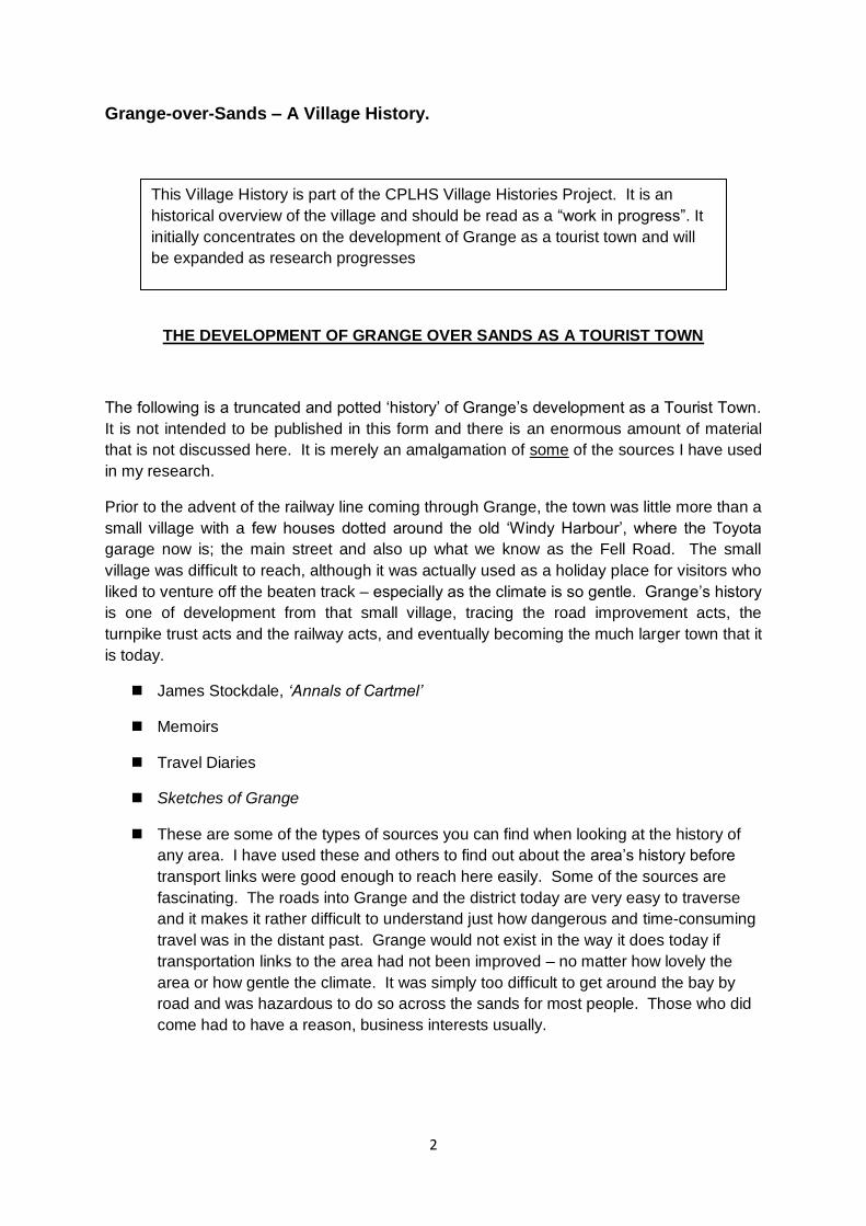
Grange-over-Sands – A Village History.
THE DEVELOPMENT OF GRANGE OVER SANDS AS A TOURIST TOWN
THE DEVELOPMENT OF GRANGE OVER SANDS AS A TOURIST TOWN
The following is a truncated and potted „history‟ of Grange‟s development as a Tourist Town.
It is not intended to be published in this form and there is an enormous amount of material
that is not discussed here. It is merely an amalgamation of some of the sources I have used
in my research.
Prior to the advent of the railway line coming through Grange, the town was little more than a
small village with a few houses dotted around the old „Windy Harbour‟, where the Toyota
garage now is; the main street and also up what we know as the Fell Road. The small
village was difficult to reach, although it was actually used as a holiday place for visitors who
liked to venture off the beaten track – especially as the climate is so gentle. Grange‟s history
is one of development from that small village, tracing the road improvement acts, the
turnpike trust acts and the railway acts, and eventually becoming the much larger town that it
is today.
James Stockdale, ‘Annals of Cartmel’
Memoirs
Travel Diaries
Sketches of Grange
These are some of the types of sources you can find when looking at the history of
any area. I have used these and others to find out about the area‟s history before
transport links were good enough to reach here easily. Some of the sources are
fascinating. The roads into Grange and the district today are very easy to traverse
and it makes it rather difficult to understand just how dangerous and time-consuming
travel was in the distant past. Grange would not exist in the way it does today if
transportation links to the area had not been improved – no matter how lovely the
area or how gentle the climate. It was simply too difficult to get around the bay by
road and was hazardous to do so across the sands for most people. Those who did
come had to have a reason, business interests usually.
This Village History is part of the CPLHS Village Histories Project. It is an
historical overview of the village and should be read as a “work in progress”. It
initially concentrates on the development of Grange as a tourist town and will
be expanded as research progresses

3
This sketch dates from approx. 1780 and looks as though it was done at Blawith rocks
(though which part I‟m not sure as the sea would have come in much further, at least to the
end of Windermere Road, therefore it could be looking down from somewhere near the site
of the Grange Hotel).
At this point in its history Grange was a sleepy place with no good roads connecting it to the
outside world. Travel to Grange was difficult, time consuming and dangerous. The whole of
the Furness and Cartmel peninsulas, and to a large extent, Westmorland, were cut off from
the rest of England. Travel between Kendal and Cartmel meant finding a way to cross the
marshes between Levens village and Whitbarrow Scar, and then traversing the hill at Tow
Tor over to High Newton, and thence to Cartmel. It was not easy before the arrival of the
Turnpike road (now the old A590).
„From the top of this hill I looked round to see the mouth of the Lone (which empties itself not
much lower). I saw Foreness, and the other part of the coast to the west, which is almost
severed from this part of the sea, for whereas the shore lay out a great way westward into
the ocean, the sea (as if enraged at it) ceased not to lash and mangle it. Nay it has
swallowed the shore quite up at some boisterous tide or other, and thereby has made three
large bays, namely Kent sand, which receives the River Ken, Leven sand, and Duddon
sand.‟ William Camden c1696, describing the view of Morecambe Bay from Lancaster.
Cartmel and Furness peninsulas were extremely cut off until around the end of the 18th
century, when, with the advent of new enclosure acts new roads were built to enable people
to access their land, and with the advent of the new turnpike roads which improved some
roads and created others, thus opening up the peninsulas to a far greater degree. The
reason for these new roads was, in effect, to enable traders to move their goods around
more easily (for example to and from the market towns of Ulverston and Kendal) and thus
help generate greater wealth in the area. The new turnpike roads had the backing of a
number of prominent landowners who expected the benefits accruing to them from the
opening up of the area to more than outweigh the disadvantages caused by creating new

4
and/or improving existing roads. The advent of the railway was similarly bound up with the
industrialisation of the Furness peninsula and the need to move goods, ore, etc. to other
areas and countries. The small hamlet that was so insignificant it hardly featured as a
separate entity in official sources benefited hugely from these advances in transport links
and communication.
This image has been taken from Sketches of Grange published in 1850. The quickest
crossing was over the sands until the turnpike roads were created.
The oversands crossing was known to be very dangerous but was also the most direct route
both into and out of the area. Therefore oversands crossings were regularly undertaken and
overseen by men appointed to the task. There is evidence that the Carters‟ offices (both the
Leven sands Carter and the crossing over the Kent) existed at the beginning of the 16th
century before Henry VIII. However, the first patent of the Duchy of Lancaster appointing a
guide for the Kent sands is dated January 29 1548, the wording of which is shown below:
… „by these presents do give and grant to Thomas Hogeson of Kents Bank in Cartmel, in
the county of Lancaster, yeoman, the office of keeper, conductor and governor of the
aforesaid sands … and also give and grant to the said Thomas one tenement in Kentsbank
in Cartmel aforesaid called the Cart House with three closes of land, also a fee or wage of
£5 per annum.‟ Quoted in E. Cuthbert Woods, „The Oversands Route between Lancaster
and Ulverston‟, in Transactions of the Cumberland and Westmoreland Antiquarian and
Archaeological Society, Vol.87 (1935), p.8
John Fell also goes on to add that there was a footnote in the Report of the Charity
Commissioners (of which he was one) which said „he seems to have been a drunkard and a
gambler, and to have been indicted for allowing travellers to drown before his eyes‟.
Certainly the role of Guide was difficult and not particularly well paid. It seems that the early
Guides (called Carter for many years) had to find other ways to make ends meet, including
5
selling ale in the early 18th century at least. John Carter (the Guide in 1715) petitioned the
Duchy of Lancaster for an increase in his annual salary (still only £5 per annum) as the value
of money had decreased and the cost of living had risen. He argued that his salary „which
by the alteration in the value of money, from what it was when the salary was established, is
now become very unequal to the expense and trouble attending that business‟.
„He has to keep two horses, summer and winter (these are not their names), and being
necessitated to attend the „EDY‟ four miles upon the sands, 12 hours in the 24, his horses
thereby, and by often passing the waters, are starved with cold and often thrown into
distempers … and the petitioner undergoes great hardships, by his being exposed to the
winds and cold upon the plain sands, and he by seeking out new fords, every variation of the
edy, and upon happening of fogs and mists, is often put in danger of his life.‟ Quoted in Fell,
CWAAS, Vol.7, p.9. According to Fell, his salary was raised to £12 – he had obviously been
underpaid for some time to have such an increase in salary!
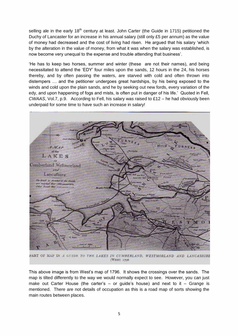
This above image is from West‟s map of 1796. It shows the crossings over the sands. The
map is tilted differently to the way we would normally expect to see. However, you can just
make out Carter House (the carter‟s – or guide‟s house) and next to it – Grange is
mentioned. There are not details of occupation as this is a road map of sorts showing the
main routes between places.
6
Elizabeth Gaskell (author of, amongst other works, Mary Barton) used to stay at a farm in
Silverdale, close to the shore. In a letter dated 10 May 1858 she wrote:
„Looking down on the bay with its slow moving train of crossers, led over the treacherous
sands by the Guide, a square man, sitting stern on his white horse, the better to be seen
when daylight ebbs…. On foggy nights the guide (who has let people drown before now
who could not pay his fee) may be heard blowing an old man‟s horn trumpet to guide by the
sound‟.
Another, unknown, lady had described the guide in 1840:
„He was a slight strange looking figure, with masses of long, unkempt hair, as rough as the
old sheep skin that was thrown across the horse he rode. On his head he wore a cap of
sheep skin‟.
Registers of Cartmel Priory show that between 1559 and 1880 141 persons were
buried there who had lost their lives on the sands
12 September 1576: „One young man buryed, which was drowned in the brodwater‟
August 1577: „One little man, roundfaced, which was drowned at Grange‟
William Stout of Lancaster noted in his autobiography under the year 1687:
„Sometime this year Christopher Harrys, a draper and grocer in Cartmell, of Great business,
but very penurious … who frequented our market at Lancaster, and usually to save the
charge of carriage, brought one or more horses to carry his goods, but in crossing the sands
some horse faltered and cast his loading, which he endeavoured to put to rights, was so long
that the flood came, and he was drowned, notwithstanding several came by and saw him,
but he would not call for assistance, otherwise might have saved his goods and life‟.
In the 18th century there was only a pack-horse track connecting Kendal with Ulverston, and
that no more than 6ft wide: „From Kendal the route was past Bradleyfield, across
Underbarrow Scar (reaching 562ft above sea level), crossing Underbarrow Pool near
Grigghall, so by Crosthwaite Green and over the river Gilpin to Bowland Bridge, where
Lancashire was entered. After reaching 747ft near Gummer‟s How, the track dropped to Fell
Foot where it divided, one branch crossing the fords at the foot of Windermere, going to
Furness Fells, the other continuing over Newby Bridge to Bouth and Penny Bridge …. The
track was impassable for vehicles‟.
J. L. Hobbs, „The Turnpike roads of North Lonsdale‟, in Transactions of the Cumberland and
Westmorland Antiquarian and Archaeological Society, New Series, Vol55 (1955), p.251
An Act of Parliament to improve the road (ie create a Turnpike road) was passed in 1763.
Turnpike roads transferred the onus of upkeep from the parish or parishes onto those who
used the roads, ie you paid to use them and this paid for their upkeep.
Act 58 Geo.iii:
The road „would be of great Advantage and Convenience to the Land Owners and
Inhabitants of the Neighbourhood and the adjacent Country and would greatly facilitate the
Communication between the Northern Parts of Lancashire and the Western Parts of

7
Yorkshire and all places to the South thereof … and would likewise be the Means of
preventing the Loss of many Lives, by avoiding a dangerous Estuary and perilous Sands …‟
Of course much of this improved road still exists but was replaced by the A590 some years
ago. Much of it still runs alongside the new road.
Thus the approaches to the Cartmel district were opened up by the early 19 th century
enabling greater access to the area. The turnpike road entered Lindale and went up Lindale
Hill and then on to High Newton. The toll house at this end being near Wilson House I think
possibly on the site of the old Little Chef as it was described as a wayside café in 1975.
„Carriages and the heaviest wagons now pass safely over 4 or 5 miles of morass where a
few years ago, except in very dry weather, the human foot could not tread with security‟.
J. Biggs writing in 1825, quoted in L A Williams, Road Transport in Cumbria in the
Nineteenth Century (1975)
„Many hundreds of miles of new roads were created in the early years of the nineteenth
century when large areas of Cumbria were enclosed. The enclosing of what had been open
land by hedges or walls was part of the move to increase agricultural production, especially
during and immediately after the Napoleonic Wars‟. Paul Hindle, Roads and Tracks of the
Lake District (Milnthorpe: Cicerone Press, 1998), p.178
Enclosure had been going on in England from the medieval period, ie the creating of field
boundaries through the use of walling or hedging to delineate single use of a large area, as
opposed to the older strip farming method. In Cumbria, by the end of the 18 th century, there
was little left to be enclosed except waste and common lands. Thus we see a period of road
improvements, of schemes to drain the marshes around this area, of new roads being
created and old ones being updated from what were originally cart tracks to passable roads.
In Grange we have the improvements of the roads leading from Cart Lane over Fell Gate to
Cartmel and of the road leading from the bottom of Grange between Eggerslack and Blawith
to Lindale – and now known as Windermere Road. That these roads existed before the
Enclosure Act of 1796 is clear from Yate‟s map of the area on the next slide dated 1786, fully
ten years before the Enclosure Act. Stockdale reminds us that enclosures of the commons
were often done illicitly by persons who used the land and wished to claim ownership by
excluding others from using „their‟ piece of land. This seems to have been settled amicably
enough by negotiating a fee for the land and paying the landowner for same.
„The road over the mosses is peculiar, as it rests upon a bog soil which swallowed up an
enormous quantity of earth in its construction, before the road was sufficiently solid, and,
long after its formation, heavy vehicles produced an undulating motion on the adjoining bog.
The mosses themselves, to a southern eye, are an object of interest‟.
„Here the peasantry procure their chief supply of fuel, and at the times of peat-harvest,
hundreds of acres of black bog are thickly overspread with a hard-working, sun-browned
population, cutting, drying, or storing the peat‟.
„These valuable beds of fuel are many feet in depth, and are very systematically cut
perpendicularly in thin slices and then divided into pieces about the size of a brick. To

8
hasten the process of drying, they are carefully piled in small stacks, the “peats” being so
arranged as to be fully exposed to the action of the sun and wind‟.
The first two quotations are taken from Guide to Grange, published in 1848 by George Lee
of Kendal and are discussing the new 1818/19 route over the marshes from Levens to
Lindale and beyond. The second quotation is taken from the update to the Guide, entitled
Sketches of Grange and published by John Hudson of Kendal in 1850.
„During the bathing season of 1826 the Crown Inn, at the top of Main Street in Grange,
offered customers „good Beds … decent Furniture and a daily supply of salt and fresh water‟,
whilst cottages within the village were made available to paying guests.‟
A. Harris, „The Seaside Resorts of Westmorland and Lancashire North of the Sands in the
Nineteenth Century‟, in Transactions of the Historic Society of Lancashire and Cheshire
Vol.115 (1963), p.148
Grange clearly had a reputation which drew in visitors to experience the climate and the sea
bathing. Trade must have been reasonable if people were prepared to let out their cottages
to paying guests – one wonders where the owners went during the period that their own
cottages were inhabited by these early tourists. Perhaps they stayed with other family
members in Grange or surrounding areas. One also wonders how many visitors the village
got during „the season‟.
„To reach Grange is increasingly easy, besides the approaches are themselves attractive
enough to reward the attempt. The ordinary route, whether approached from the north or
south, commences with Levens Bridge, and opens with an extensive view of that magnificent
escarpment of rock - Whitbarrow Scar, lifting its head as if a rival of Underbarrow Scar,
whilst between their giant-like gateway, and over a rich brown foreground of cultivated moss,
the cloud-capt hills at the head of Windermere are seen, and fill up the gap.‟
„Passing under Whitbarrow Scar, near to Castle Head, through Lindale and over Blawith Hill,
shadowed by Eggerslack wood, all which we expect to describe as objects of observation
from Grange, we arrive by a good road at our destination‟.
This quotation is taken from Guide to Grange first published by George Lee of Finkle Street
in Kendal in 1848. It was originally published in the Kendal Mercury. By 1850 it is clear that
the difficulties faced by earlier travellers trying to reach the area, are now no longer causing
any problems. The 1818 Turnpike road is appreciated, works well, and is drawing people
into the area to visit what is on the verge of becoming a tourist town. However, we are still
not entirely there. The only accommodation for visitors, apart from perhaps lodging in
someone‟s house, is the Crown Inn at the top of Crown Hill, where the author of Guide to
Grange apparently stayed. Supplies for the village had to be brought in from Kendal. These
were carted in by a woman called Peggy Keith for a good part of the 19 th century. She also
travelled to Cartmel to procure meat from the area‟s only butcher to sell to Grange residents.
There is a photograph of Peggy with her cart in I. Hunt, Old Lakeland Transport, found in
Grange library, the image is on page 12 and is dated to 1870. Clearly she still had a role to
play at that later date.
9
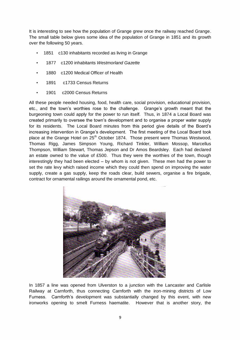
It is interesting to see how the population of Grange grew once the railway reached Grange.
The small table below gives some idea of the population of Grange in 1851 and its growth
over the following 50 years.
• 1851 c130 inhabitants recorded as living in Grange
• 1877 c1200 inhabitants Westmorland Gazette
• 1880 c1200 Medical Officer of Health
• 1891 c1733 Census Returns
• 1901 c2000 Census Returns
All these people needed housing, food, health care, social provision, educational provision,
etc., and the town‟s worthies rose to the challenge. Grange‟s growth meant that the
burgeoning town could apply for the power to run itself. Thus, in 1874 a Local Board was
created primarily to oversee the town‟s development and to organise a proper water supply
for its residents. The Local Board minutes from this period give details of the Board‟s
increasing intervention in Grange‟s development. The first meeting of the Local Board took
place at the Grange Hotel on 25th October 1874. Those present were Thomas Westwood,
Thomas Rigg, James Simpson Young, Richard Tinkler, William Mossop, Marcellus
Thompson, William Stewart, Thomas Jepson and Dr Amos Beardsley. Each had declared
an estate owned to the value of £500. Thus they were the worthies of the town, though
interestingly they had been elected – by whom is not given. These men had the power to
set the rate levy which raised income which they could then spend on improving the water
supply, create a gas supply, keep the roads clear, build sewers, organise a fire brigade,
contract for ornamental railings around the ornamental pond, etc.
In 1857 a line was opened from Ulverston to a junction with the Lancaster and Carlisle
Railway at Carnforth, thus connecting Carnforth with the iron-mining districts of Low
Furness. Carnforth‟s development was substantially changed by this event, with new
ironworks opening to smelt Furness haematite. However that is another story, the

10
importance for Grange was that the new line of the railway passed through Grange. The
railway was not extended in order to carry people, however, the effect it had on the rather
sleepy little village was enormous. We have already seen how the need for good transport
links to ease the distribution of goods, and thus generate wealth, had made access and
egress to and from this area much better and easier, and how these improvements had
opened the way for Grange to begin its metamorphosis into a resort. But it was the railway
and the creation of a station here at Grange that really enabled the village to capitalise on its
sheltered position.
This image is taken from Robert Swain‟s recently published book of Francis Frith
photographs. It is dated c1929 and shows the park neatly laid out, and the ramp from the
bridge over the line.
The Furness Railway Company were canny investors. Their investment in the growth of
Barrow, through the creation of syndicates which included investment in the steel works, the
jute company, building companies, the docks etc., ensured that the tiny village of Barrow
was transformed into a large and viable town during the 19th century. Those same men also
became interested in the possibility that Grange could become a viable investment too in the
shape of a tourist destination. The railway existed – it could carry passengers as well as raw
materials. Visitors began to arrive in Grange in much greater numbers, their journey being
much improved and much quicker by train. The Furness Railway Company, ever sharp to
investment potential, turned their incredible talents towards creating the stepping stones for
a tourist town.
The first designs for the railway station were drawn up by Paley and Austin in 1865 although
the station itself was not completed until 1872. I remember the ladies waiting room with its
open fire (not lit) and „facilities‟, now a private house. However, it was not just the railway
station itself which the company built. The approaches to the railway station, at the foot of
Windermere Road and passed what is now the Toyota garage, had to be laid out as this
enabled visitors much easier access to the village itself. It must have been a massive
project to construct not just the station but also the approaches, bearing in mind that
practically all of it was built on marshy land and sand. In 1877 the railway company were
involved in another development, access to the shore via a subway underneath the railway
line. The embankment that had been built to carry the line through Grange along the
shoreline was built of compressed sand – as we saw when the new subway was built a
couple of years ago. The whole embankment had been supported on the shore side by
massive blocks of limestone. The 1877 subway gave visitors access to the short length of
promenade which the railway company had built from 1866.
The Furness Railway Company invested in The Grange Hotel Company Ltd., which was
formed to build the Grange Hotel in 1866 to cater for the visitors arriving in Grange to sample
the „genteel‟ surroundings. The new visitors were not expected to sample the delights of
lodging in someone else‟s house, nor were they expected to put up with the simple
surroundings and fayre provided by the Crown Inn. The Grange Hotel was also designed by
Paley and Austin which explains the similarity between the Hotel and the station. It is a
visual link between the new almost luxurious method of transport and the luxury on offer to
the tourist. No visitor could miss the Hotel, set as it is nestling into the side of Blawith
woods. It is inviting and pleasing to look at and very grand. What promise. It must also have
been the perfect advertisement persuading new visitors that Grange could provide anything
11
the discerning visitor could wish for. This image was taken from the web – it shows the new
extension which, of course, did not exist in 1867. An 1876 Directory described Grange as
„this delightful and fashionable watering place‟ with „A splendid Hotel in the Italian style of
architecture …having 70 rooms also large refreshment rooms, stables, etc., swimming and
other baths are fitted up and supplied with sea water‟.
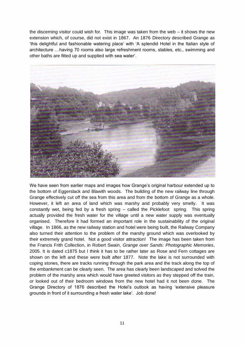
We have seen from earlier maps and images how Grange‟s original harbour extended up to
the bottom of Eggerslack and Blawith woods. The building of the new railway line through
Grange effectively cut off the sea from this area and from the bottom of Grange as a whole.
However, it left an area of land which was marshy and probably very smelly. It was
constantly wet, being fed by a fresh spring – called the Picklefoot spring. This spring
actually provided the fresh water for the village until a new water supply was eventually
organised. Therefore it had formed an important role in the sustainability of the original
village. In 1866, as the new railway station and hotel were being built, the Railway Company
also turned their attention to the problem of the marshy ground which was overlooked by
their extremely grand hotel. Not a good visitor attraction! The image has been taken from
the Francis Frith Collection, in Robert Swain, Grange over Sands: Photographic Memories,
2005. It is dated c1875 but I think it has to be rather later as Rose and Fern cottages are
shown on the left and these were built after 1877. Note the lake is not surrounded with
coping stones, there are tracks running through the park area and the track along the top of
the embankment can be clearly seen. The area has clearly been landscaped and solved the
problem of the marshy area which would have greeted visitors as they stepped off the train,
or looked out of their bedroom windows from the new hotel had it not been done. The
Grange Directory of 1876 described the Hotel‟s outlook as having „extensive pleasure
grounds in front of it surrounding a fresh water lake‟. Job done!
12
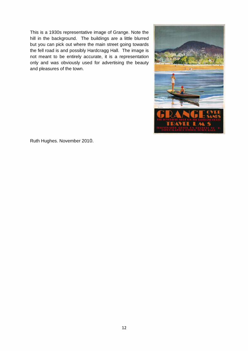
This is a 1930s representative image of Grange. Note the
hill in the background. The buildings are a little blurred
but you can pick out where the main street going towards
the fell road is and possibly Hardcragg Hall. The image is
not meant to be entirely accurate, it is a representation
only and was obviously used for advertising the beauty
and pleasures of the town.
Ruth Hughes. November 2010.