view shafts - aucklandcity.govt.nz
TRANSCRIPT
ANNEX 2
VIEW SHAFTS
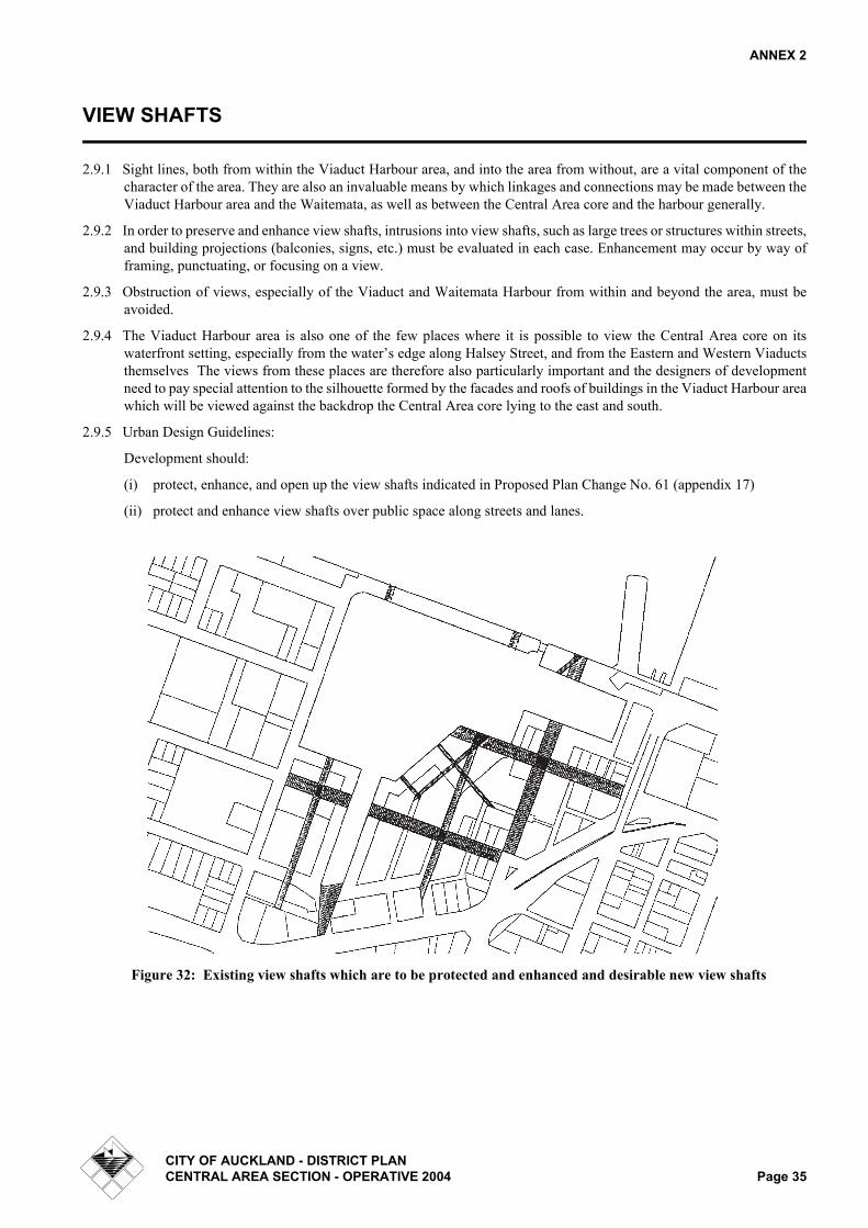
2.9.1 Sight lines, both from within the Viaduct Harbour area, and into the area from without, are a vital component of thecharacter of the area. They are also an invaluable means by which linkages and connections may be made between theViaduct Harbour area and the Waitemata, as well as between the Central Area core and the harbour generally.
2.9.2 In order to preserve and enhance view shafts, intrusions into view shafts, such as large trees or structures within streets,and building projections (balconies, signs, etc.) must be evaluated in each case. Enhancement may occur by way offraming, punctuating, or focusing on a view.
2.9.3 Obstruction of views, especially of the Viaduct and Waitemata Harbour from within and beyond the area, must beavoided.
2.9.4 The Viaduct Harbour area is also one of the few places where it is possible to view the Central Area core on itswaterfront setting, especially from the water’s edge along Halsey Street, and from the Eastern and Western Viaductsthemselves The views from these places are therefore also particularly important and the designers of developmentneed to pay special attention to the silhouette formed by the facades and roofs of buildings in the Viaduct Harbour areawhich will be viewed against the backdrop the Central Area core lying to the east and south.
2.9.5 Urban Design Guidelines:
Development should:
(i) protect, enhance, and open up the view shafts indicated in Proposed Plan Change No. 61 (appendix 17)
(ii) protect and enhance view shafts over public space along streets and lanes.
Figure 32: Existing view shafts which are to be protected and enhanced and desirable new view shafts
CITY OF AUCKLAND - DISTRICT PLANCENTRAL AREA SECTION - OPERATIVE 2004 Page 35

ANNEX 2
CITY BLOCKS
3.0.1 In traditional cities, city blocks form the ‘solid’ material of the city, out of which the public spaces appear to have beencarved. Private development is thus shaped by the layout of the public space network, and public space is defined byprivate development within the city block.
3.0.2 The Viaduct Harbour area is currently characterised by city blocks which are larger than those in most other parts ofthe Central Area core, and which make the area relatively impermeable to pedestrian and vehicular movement. Theseblocks create obstacles to people trying to access the waterfront.
Figure 33: Private development as defined by the public space network
Figure 34: Public space network as defined by private development
CITY OF AUCKLAND - DISTRICT PLANPage 36 CENTRAL AREA SECTION - OPERATIVE 2004

ANNEX 2
3.0.3 Urban Design Guidelines:
Development should:
(i) make city blocks more physically, visually, and psychologically permeable by further transecting them withstreets, lanes, arcades, and through-site links which, while they may remain in private ownership, should bedesigned to be publicly accessible, welcoming, and able to be utilised at all times.
(ii) provide streets, lanes, alleyways, and arcades, which:
- reduce the scale of the built footprints on any ‘city block’/site.
- create a pattern of public circulation which focuses upon the two main public squares.
- respect the historic city grid structuring influence of the Felton Mathew Plan.
- recognise all other design guideline directives.
(iii) ensure that buildings are constructed to align their front facades precisely with the boundary between their cityblock/site and the adjacent public space. Buildings should not be set back from the front or side boundaries oftheir site. Where there are two front boundaries, such as would be the case on a corner site, or where a site spansbetween two public spaces, then the same requirements will apply.
(iv) ensure that there is continuity between building facades so that collectively they produce a continuous built edgedefinition to any given length of public space.
Figure 35: Illustrations of the appropriate scale of city blocks/sites, and of buildings continuously aligned with the boundary between their site and adjoining public space
CITY OF AUCKLAND - DISTRICT PLANCENTRAL AREA SECTION - OPERATIVE 2004 Page 37

ANNEX 2
BUILDINGS
BUILDING CHARACTER:
4.1.1 All buildings fronting on to public squares, waterfront promenades, streets, and lanes should contribute to the feltvolume1 of those spaces.
4.1.2 The scale and character of building elevations will be profoundly influenced by the desired character of the adjoiningpublic space.
4.1.3 Urban Design Guidelines:
Development should:
(i) produce buildings of varied architectural character within individual city blocks and between development sites.
(ii) produce building component proportions, dimensions, details etc., in scale with the human figure. The generalscale of city resulting from this would be not unlike that of the existing area of Auckland city comprising HighStreet, Vulcan Lane, O’Connell Street, Lorne Street, or historically intact parts of the Viaduct Harbour itself in1996, ie: Market Place and Customs Street West.
(iii) within the scale outlined above, exhibit simple, traditional street-oriented architectural forms and geometry, andprovide relatively low key “background” architectures, quiet backdrops/stage sets, in order to contrast with andthereby highlight and throw into focus the ever-changing and potentially theatrical quality, intensity, colour, andintricate details of activities associated with the streets, the public places, and the waters of the Viaduct andWaitemata Harbour.
(iv) produce buildings with a predominance of vertical rather than horizontal emphases on their elevations. Thedesign of elements on these elevations, the degree to which they can be individually varied by the buildingoccupants (eg. opening windows, doors, shutters, etc.), together with balconies, awnings, window boxes etc.,and variations in materials will all contribute to the visual reduction in the scale of buildings and therebycontribute towards achieving an appropriate scale for the adjoining public places.
(v) include activities which have a strong interaction with the use of the adjoining public space.
(vi) take advantage of operational installations, such as ice towers, which offer unique design opportunities forlandmark elements on the Viaduct foreshore.
(vii) ensure that all temporary structures should show design sensitivity and recognition of the primary principles setout in these guidelines of public space quality.
(viii)take every opportunity to architecturally express their city/ harbour edge setting, and their Pacific regional andcultural qualities.
1. felt volume: a spatial characteristic which is generated by and responds to the characteristics of the vertical wall planes that bound the volume on either side. Felt volume depends upon the elements of a street (car-riageway, footpath, and flanking buildings) existing interdependently with one another.
CITY OF AUCKLAND - DISTRICT PLANPage 38 CENTRAL AREA SECTION - OPERATIVE 2004

ANNEX 2
WALLS
4.2.1 The walls of buildings aligning a public space collectively form the most important single factor in determining thecharacter of that space. The architectural design of these vertical building surfaces and the activities which theyreveal to the adjoining public space are equally important.
4.2.2 Public spaces derive their feeling of volume from the vertical building surfaces that front on to them, while thecharacter of these surfaces contributes to the atmosphere of the spaces.
4.2.3 There are two particularly important design considerations in the composition of public space walls formed bybuilding facades:
- one is the division of the vertical dimension of the wall into the three main elevational zones of ‘base’(connection with the ground), ‘middle’, and ‘top’ (connection with the sky). Typically, the ground floor has ahigher floor to ceiling height than the floors above (with the exception of the piano nobile1 tradition). The topfloor is sometimes of a lesser floor to ceiling height than those below.
- the other is the division of the horizontal dimension of the wall into a series of segments of limited widths(traditionally related to lot sizes and boundaries) which collectively form a continuous edge along the length, oraround the edge, of the public space.
4.2.4 Other important design considerations include:
- the degree of physical, spatial, and functional relationship between the ground floor and the adjoining publicspace.
- the ratio of window opening to wall surface.
- a gradual reduction in the ratio of window openings to wall surface in the progression from the ground floorlevel to the top of the building.
- the proportions of window and/or door openings.
- variation in the window size, reducing from the largest in the base zone, through the middle, to the smallestwindows in the top zone.
- the dominance of vertical over horizontal elevational and elemental emphases.
- the thickness of walls, as revealed by the depths of window and door openings.
- the transparency of openings to provide contrast between solid and void.
- details such as window sills, lintels, reveals, pediments, and facings.
1. piano nobile: the architecturally most grand and ornate first floor level of residential building types. It typically had tallest of all windows on the street elevation, a floor to ceiling height greater than any other in the building, and was used for the most public rooms (‘reception’ and ‘drawing’) in the house.
CITY OF AUCKLAND - DISTRICT PLANCENTRAL AREA SECTION - OPERATIVE 2004 Page 39

ANNEX 2
4.2.5 Urban Design Guidelines:
Development should:
(i) ensure that walls create felt volumes of public space. Building elevations should rise to their full height on theirstreet boundary line, and not step back as they increase in height.
(ii) provide walls which continuously define the edge of the street space, but with individual variation inarchitectural character along any given length of street. Variety in street architecture will contribute to incident,intensity, and richness within the street scene. Long lengths of undifferentiated wall are dull. monotonous, andunacceptable. Avoid the use of ‘curtain wall’ cladding.
(iii) produce walls with vertical rather than horizontal proportions and elemental emphases. When seen inperspective, these vertical emphases produce a rhythmic series of vertical elements which attract and hold theinterest of the human eye. Vertical emphases are preferable to horizontal emphases which reinforce thevanishing point of the street scene and stimulate the eye to speed rapidly to the end of the vista.
(iv) comprise walls which are architecturally demarcated into three distinct vertical zones: - a ‘base’ (connecting it tothe public realm at ground level), a ‘middle’, and a ‘top’ (both signifying the upper limit of the street space andconnecting it to the sky).
- the ‘base’ zone should deploy the architectural elements of columns, windows, doors, and recessed entranceways, all with the purpose of achieving a strong visual and physical integration of exterior and interiorworlds, public and private space.
- the ‘middle’ zone should be further subdivided within its vertical dimension.
- the ‘top’ zone should employ the well established architectural elements of cornice, eave, parapet, andpediment to terminate the upper limits of the building, although these archetypal components may be givennew interpretations and constructed of materials expressive of contemporary times.They should not becomea dominant element in the facade.
(v) reinforce these ‘zones’ by reducing the size of windows in a progression from the largest at the base, through themiddle, to the smallest at the top.
(vi) ensure that walls at ground floor level are visually and functionally continuous with the adjoining public space.Windows and doors should be able to open up the full width of any individual use at ground floor level.However, large areas of glass should be subdivided into well proportioned components.
(vii) ensure that walls above ground floor level read primarily as solid planes into which clear glazed openings havebeen placed.
(viii) achieve a gradual reduction in the ratio of window and/or door openings to wall surface in the progression fromthe ground floor level to the top of the building
(ix) design the height to width proportions of window and/or door openings to produce a square, or a verticaldirectional emphasis.
(x) take particular care that the compositional proportions and qualities of the walls above ground floor level areconsistent with and are carried down through the ground floor level, and vice versa.
(xi) provide opening windows, irrespective of whether or not a building development is air-conditioned.
CITY OF AUCKLAND - DISTRICT PLANPage 40 CENTRAL AREA SECTION - OPERATIVE 2004

ANNEX 2
(xii) ensure that any gabled or other shaped parapets forming the upper limits of the walls and a silhouette against thesky and/or city are an accurate expression of the cross-section of the roof immediately behind the parapet. Free-standing triangular or other shaped pediments at the tops of building facades would appear thin and pretentious,especially when viewed from the upper levels of existing buildings in the Central Area core to the east andsouth. They are also architecturally ‘dishonest’ in that they do not accurately express the form of the roofbehind. In the extreme they can reduce the building to pastiche of a by-gone era.
Figure 36: Illustrations of the appropriate character of public space-defining building walls
CITY OF AUCKLAND - DISTRICT PLANCENTRAL AREA SECTION - OPERATIVE 2004 Page 41

ANNEX 2
Figure 37: Illustrations of the appropriate character of public space-defining building walls
CITY OF AUCKLAND - DISTRICT PLANPage 42 CENTRAL AREA SECTION - OPERATIVE 2004
ANNEX 2
PARAPETS
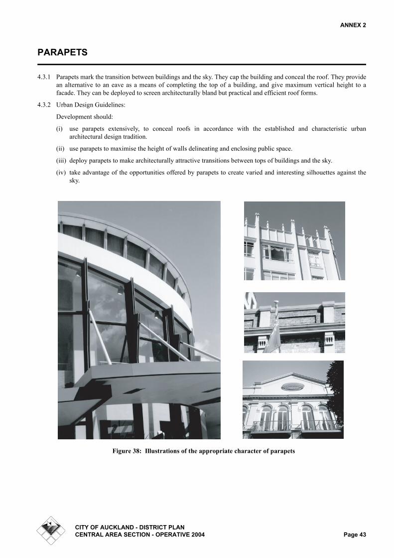
4.3.1 Parapets mark the transition between buildings and the sky. They cap the building and conceal the roof. They providean alternative to an eave as a means of completing the top of a building, and give maximum vertical height to afacade. They can be deployed to screen architecturally bland but practical and efficient roof forms.
4.3.2 Urban Design Guidelines:
Development should:
(i) use parapets extensively, to conceal roofs in accordance with the established and characteristic urbanarchitectural design tradition.
(ii) use parapets to maximise the height of walls delineating and enclosing public space.
(iii) deploy parapets to make architecturally attractive transitions between tops of buildings and the sky.
(iv) take advantage of the opportunities offered by parapets to create varied and interesting silhouettes against thesky.
Figure 38: Illustrations of the appropriate character of parapets
CITY OF AUCKLAND - DISTRICT PLANCENTRAL AREA SECTION - OPERATIVE 2004 Page 43

ANNEX 2
COLONNADES
4.4.1 Colonnades are an attractive traditional form of shelter for pedestrian circulation. They provide a covered space,recessed into the ground floor level of a building, with a regular rhythm of columns interlocking public space withadjoining buildings.
4.4.2 Viewed from within an adjoining public space, a colonnade provides depth and a vertical emphasis to the groundfloor level of a building facade, and the columns can provide a basis for establishing the horizontal subdivision of thefacade above.
4.4.3 Urban Design Guidelines:
Development should:
(i) ensure that the ground surfaces of colonnades are fully compatible and integrated with adjacent public spacesurfaces.
Figure 39: Illustrations of the appropriate character of colonnades
CITY OF AUCKLAND - DISTRICT PLANPage 44 CENTRAL AREA SECTION - OPERATIVE 2004