3.5 principle 5/response - aucklandcity.govt.nz
TRANSCRIPT
Page 20Wynyard Quarter - Urban Design Background Information October 2010
3.5Principle 5/Response
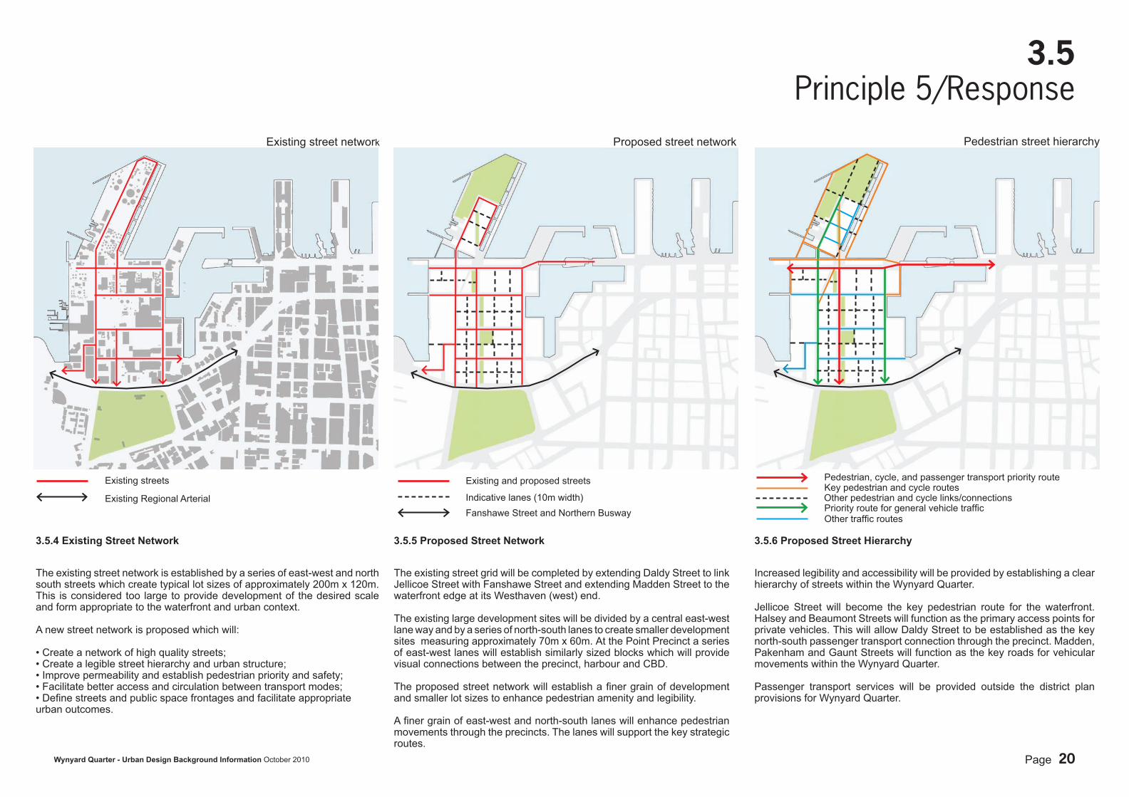
3.5.4 Existing Street Network
The existing street network is established by a series of east-west and north south streets which create typical lot sizes of approximately 200m x 120m. This is considered too large to provide development of the desired scale and form appropriate to the waterfront and urban context.
A new street network is proposed which will:
• Create a network of high quality streets;• Create a legible street hierarchy and urban structure;• Improve permeability and establish pedestrian priority and safety;• Facilitate better access and circulation between transport modes;• Defi ne streets and public space frontages and facilitate appropriate urban outcomes.
3.5.6 Proposed Street Hierarchy
Increased legibility and accessibility will be provided by establishing a clear hierarchy of streets within the Wynyard Quarter.
Jellicoe Street will become the key pedestrian route for the waterfront. Halsey and Beaumont Streets will function as the primary access points for private vehicles. This will allow Daldy Street to be established as the key north-south passenger transport connection through the precinct. Madden, Pakenham and Gaunt Streets will function as the key roads for vehicular movements within the Wynyard Quarter.
Passenger transport services will be provided outside the district plan provisions for Wynyard Quarter.
3.5.5 Proposed Street Network
The existing street grid will be completed by extending Daldy Street to link Jellicoe Street with Fanshawe Street and extending Madden Street to the waterfront edge at its Westhaven (west) end.
The existing large development sites will be divided by a central east-west lane way and by a series of north-south lanes to create smaller development sites measuring approximately 70m x 60m. At the Point Precinct a series of east-west lanes will establish similarly sized blocks which will provide visual connections between the precinct, harbour and CBD.
The proposed street network will establish a fi ner grain of development and smaller lot sizes to enhance pedestrian amenity and legibility.
A fi ner grain of east-west and north-south lanes will enhance pedestrian movements through the precincts. The lanes will support the key strategic routes.
Existing streets
Existing Regional Arterial
Existing and proposed streets
Indicative lanes (10m width)
Pedestrian, cycle, and passenger transport priority route
Other traffi c routes
Key pedestrian and cycle routes
Fanshawe Street and Northern Busway
Existing street network Proposed street network Pedestrian street hierarchy
Priority route for general vehicle traffi cOther pedestrian and cycle links/connections

Page 21Wynyard Quarter - Urban Design Background Information October 2010
3.6Principle 6
The redevelopment of the Wynyard Quarter provides the opportunity to encourage a mix of appropriate waterfront activities that establish a cohesive living, working and entertainment destination.
The urban design concept creates four distinct precincts with the potential for each to establish an identifi able urban character and mix of uses which support the long-term economic and social sustainability of the overall Wynyard Quarter.
These four key precincts are:
1. The Point Precinct - commercial/residential/entertainment and open space destination; 2. The Jellicoe Precinct - entertainment/retail/commercial and social hub;3. The Central Precinct - predominantly commercial and residential activities;
3.
2.
4.
Central Precinct
Point Precinct
Jellicoe Precinct
1.
Waterfront activity zones
Facilitating a Mix of Uses and Activities
Pt. Erin
St. Mary’s Bay
Ponsonby
Victoria Park
CBD
Freeman’s Bay
Albert Park
Page 22Wynyard Quarter - Urban Design Background Information October 2010
3.6Principle 6/Response
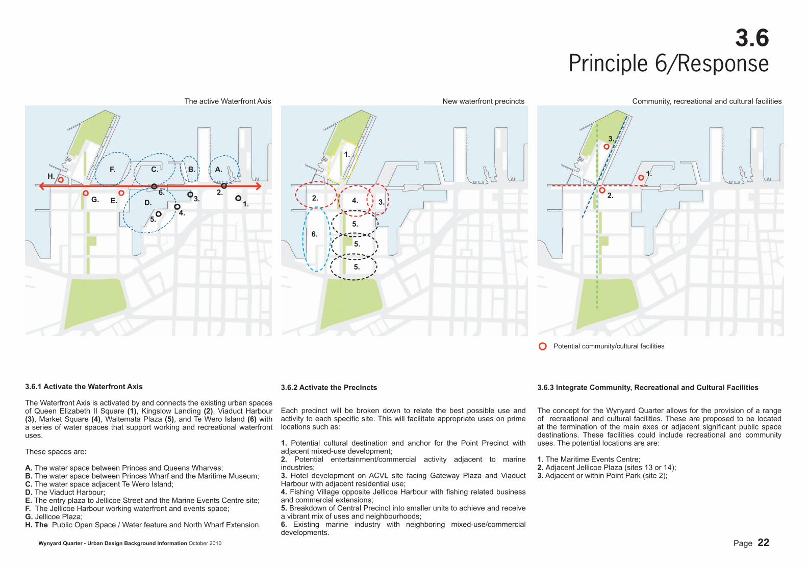
3.6.3 Integrate Community, Recreational and Cultural Facilities
The concept for the Wynyard Quarter allows for the provision of a range of recreational and cultural facilities. These are proposed to be located at the termination of the main axes or adjacent signifi cant public space destinations. These facilities could include recreational and community uses. The potential locations are are: 1. The Maritime Events Centre; 2. Adjacent Jellicoe Plaza (sites 13 or 14);3. Adjacent or within Point Park (site 2);
3.6.2 Activate the Precincts
Each precinct will be broken down to relate the best possible use and activity to each specifi c site. This will facilitate appropriate uses on prime locations such as:
1. Potential cultural destination and anchor for the Point Precinct with adjacent mixed-use development;2. Potential entertainment/commercial activity adjacent to marine industries;3. Hotel development on ACVL site facing Gateway Plaza and Viaduct Harbour with adjacent residential use;4. Fishing Village opposite Jellicoe Harbour with fi shing related business and commercial extensions;5. Breakdown of Central Precinct into smaller units to achieve and receive a vibrant mix of uses and neighbourhoods;6. Existing marine industry with neighboring mixed-use/commercial developments.
3.
1.
4.2.
3.6.1 Activate the Waterfront Axis
The Waterfront Axis is activated by and connects the existing urban spaces of Queen Elizabeth II Square (1), Kingslow Landing (2), Viaduct Harbour (3), Market Square (4), Waitemata Plaza (5), and Te Wero Island (6) with a series of water spaces that support working and recreational waterfront uses.
These spaces are:
A. The water space between Princes and Queens Wharves; B. The water space between Princes Wharf and the Maritime Museum; C. The water space adjacent Te Wero Island; D. The Viaduct Harbour; E. The entry plaza to Jellicoe Street and the Marine Events Centre site; F. The Jellicoe Harbour working waterfront and events space; G. Jellicoe Plaza;H. The Public Open Space / Water feature and North Wharf Extension.
E.G.
H.
2.6.3.
4.5.
1.
A.B.C.F.
D.
6.
5.
5.
5.
Potential community/cultural facilities
1.
2.
3.
The active Waterfront Axis New waterfront precincts Community, recreational and cultural facilities
Page 23Wynyard Quarter - Urban Design Background Information October 2010
3.7Principle 7
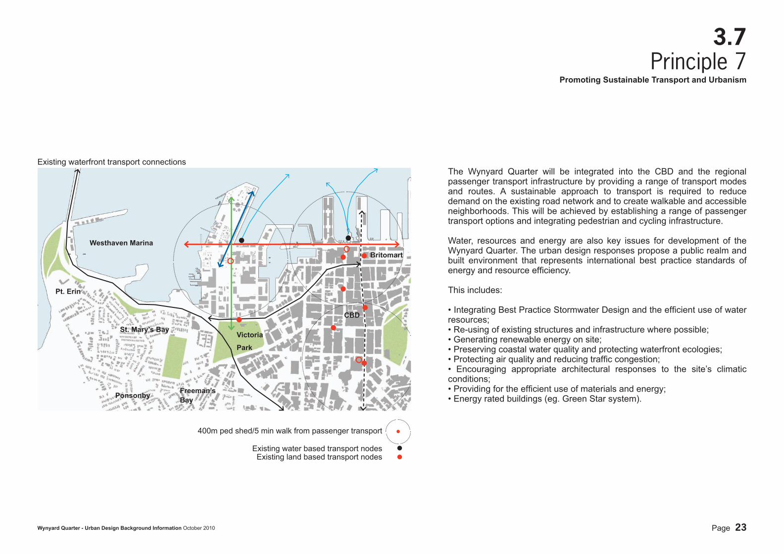
The Wynyard Quarter will be integrated into the CBD and the regional passenger transport infrastructure by providing a range of transport modes and routes. A sustainable approach to transport is required to reduce demand on the existing road network and to create walkable and accessible neighborhoods. This will be achieved by establishing a range of passenger transport options and integrating pedestrian and cycling infrastructure.
Water, resources and energy are also key issues for development of the Wynyard Quarter. The urban design responses propose a public realm and built environment that represents international best practice standards of energy and resource effi ciency.
This includes:
• Integrating Best Practice Stormwater Design and the effi cient use of water resources; • Re-using of existing structures and infrastructure where possible;• Generating renewable energy on site;• Preserving coastal water quality and protecting waterfront ecologies; • Protecting air quality and reducing traffi c congestion; • Encouraging appropriate architectural responses to the site’s climatic conditions;• Providing for the effi cient use of materials and energy;• Energy rated buildings (eg. Green Star system).
CBD
400m ped shed/5 min walk from passenger transport
Existing waterfront transport connections
Ponsonby
Westhaven Marina
Victoria
Park
Britomart
Promoting Sustainable Transport and Urbanism
Pt. Erin
St. Mary’s Bay
Freeman’s Bay
Existing water based transport nodesExisting land based transport nodes
Page 24Wynyard Quarter - Urban Design Background Information October 2010
3.7Principle 7/Response
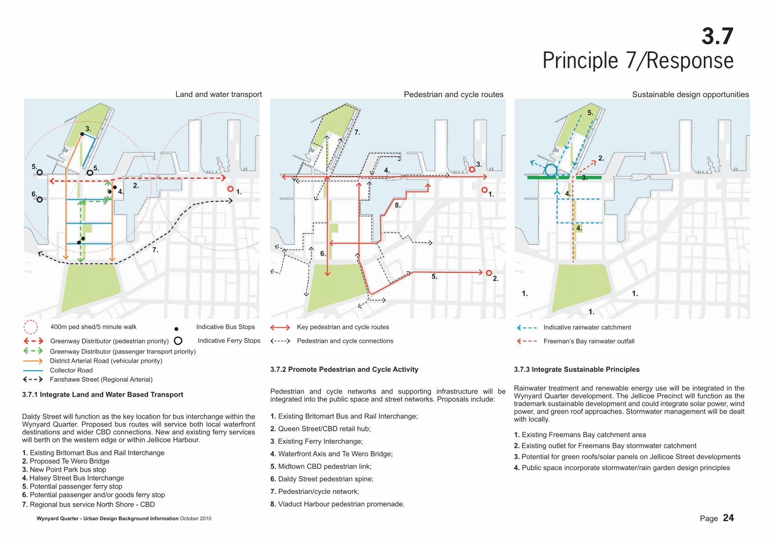
3.7.2 Promote Pedestrian and Cycle Activity
Pedestrian and cycle networks and supporting infrastructure will be integrated into the public space and street networks. Proposals include:
1. Existing Britomart Bus and Rail Interchange;
2. Queen Street/CBD retail hub;
3. Existing Ferry Interchange;
4. Waterfront Axis and Te Wero Bridge;
5. Midtown CBD pedestrian link;
6. Daldy Street pedestrian spine;
7. Pedestrian/cycle network;
8. Viaduct Harbour pedestrian promenade.
400m ped shed/5 minute walk
3.7.1 Integrate Land and Water Based Transport
Daldy Street will function as the key location for bus interchange within the Wynyard Quarter. Proposed bus routes will service both local waterfront destinations and wider CBD connections. New and existing ferry services will berth on the western edge or within Jellicoe Harbour.
1. Existing Britomart Bus and Rail Interchange2. Proposed Te Wero Bridge 3. New Point Park bus stop4. Halsey Street Bus Interchange5. Potential passenger ferry stop6. Potential passenger and/or goods ferry stop 7. Regional bus service North Shore - CBD
4.
3.
2.1.
5.
Indicative Bus Stops
Greenway Distributor (pedestrian priority)
Key pedestrian and cycle routes
Pedestrian and cycle connections
1.
2.
3.4.
5.
6.
7.
8.
Greenway Distributor (passenger transport priority)District Arterial Road (vehicular priority)Collector Road
Indicative Ferry Stops
7.
3.7.3 Integrate Sustainable Principles
Rainwater treatment and renewable energy use will be integrated in the Wynyard Quarter development. The Jellicoe Precinct will function as the trademark sustainable development and could integrate solar power, wind power, and green roof approaches. Stormwater management will be dealt with locally.
1. Existing Freemans Bay catchment area2. Existing outlet for Freemans Bay stormwater catchment3. Potential for green roofs/solar panels on Jellicoe Street developments4. Public space incorporate stormwater/rain garden design principles
1.
2.
5.
3.
4.
Fanshawe Street (Regional Arterial)
Land and water transport Pedestrian and cycle routes Sustainable design opportunities
5.
6.
1.1.
Indicative rainwater catchment
Freeman’s Bay rainwater outfall
4.
Page 25Wynyard Quarter - Urban Design Background Information October 2010
5.1Existing Site
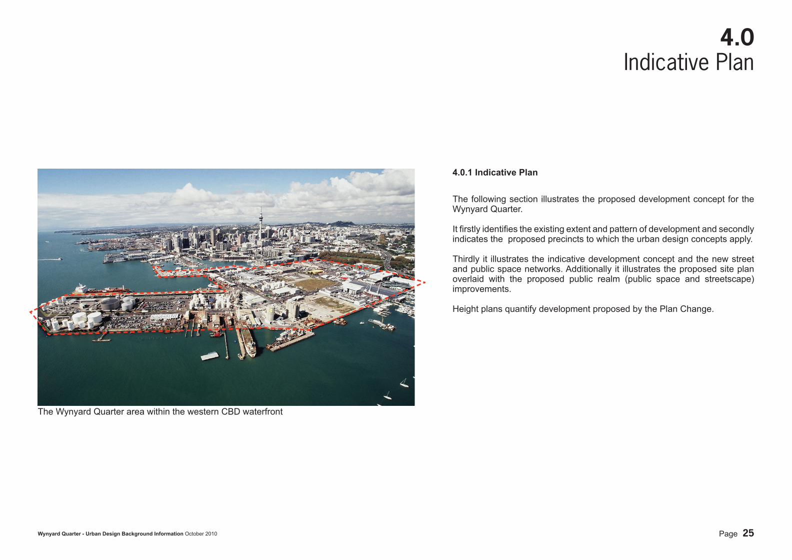
4.0Indicative Plan
4.0.1 Indicative Plan
The following section illustrates the proposed development concept for the Wynyard Quarter. It fi rstly identifi es the existing extent and pattern of development and secondly indicates the proposed precincts to which the urban design concepts apply.
Thirdly it illustrates the indicative development concept and the new street and public space networks. Additionally it illustrates the proposed site plan overlaid with the proposed public realm (public space and streetscape) improvements.
Height plans quantify development proposed by the Plan Change.
The Wynyard Quarter area within the western CBD waterfront
Page 26Wynyard Quarter - Urban Design Background Information October 2010
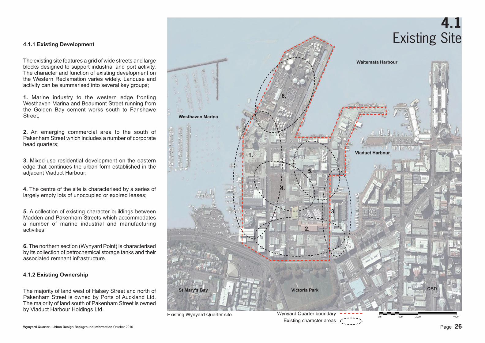
4.1Existing Site4.1.1 Existing Development
The existing site features a grid of wide streets and large blocks designed to support industrial and port activity. The character and function of existing development on the Western Reclamation varies widely. Landuse and activity can be summarised into several key groups;
1. Marine industry to the western edge fronting Westhaven Marina and Beaumont Street running from the Golden Bay cement works south to Fanshawe Street;
2. An emerging commercial area to the south of Pakenham Street which includes a number of corporate head quarters;
3. Mixed-use residential development on the eastern edge that continues the urban form established in the adjacent Viaduct Harbour;
4. The centre of the site is characterised by a series of largely empty lots of unoccupied or expired leases;
5. A collection of existing character buildings between Madden and Pakenham Streets which accommodates a number of marine industrial and manufacturing activities;
6. The northern section (Wynyard Point) is characterised by its collection of petrochemical storage tanks and their associated remnant infrastructure.
4.1.2 Existing Ownership
The majority of land west of Halsey Street and north of Pakenham Street is owned by Ports of Auckland Ltd. The majority of land south of Pakenham Street is owned by Viaduct Harbour Holdings Ltd.
Wynyard Quarter boundaryExisting character areas
2.
1.
3.
4.
5.
6.
Existing Wynyard Quarter site
Waitemata Harbour
Viaduct Harbour
Westhaven Marina
Victoria ParkSt Mary’s Bay CBD
0m 100m 200m 400m
Page 27Wynyard Quarter - Urban Design Background Information October 2010
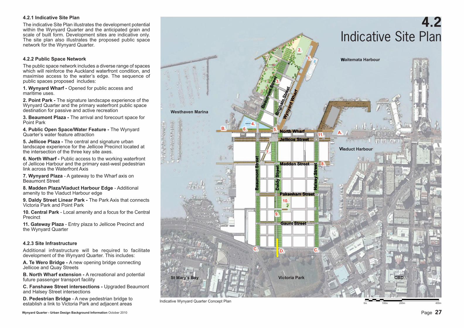
4.2Indicative Site PlanWaitemata Harbour
Viaduct Harbour
Westhaven Marina
Dal
dy S
tree
t
Bea
umon
t Str
eet
Hal
sey
Stre
et
Jellicoe Street
Madden Street
Pakenham Street
Gaunt Street
Beau
mon
t Stre
etBr
igha
m S
treet
Wyn
yard
Wha
rf
North Wharf
0m 100m 200m 400m
4.2.1 Indicative Site PlanThe indicative Site Plan illustrates the development potential within the Wynyard Quarter and the anticipated grain and scale of built form. Development sites are indicative only. The site plan also illustrates the proposed public space network for the Wynyard Quarter.
4.2.2 Public Space NetworkThe public space network includes a diverse range of spaces which will reinforce the Auckland waterfront condition, and maximise access to the water’s edge. The sequence of public spaces proposed includes:1. Wynyard Wharf - Opened for public access and maritime uses.2. Point Park - The signature landscape experience of the Wynyard Quarter and the primary waterfront public space destination for passive and active recreation3. Beaumont Plaza - The arrival and forecourt space for Point Park 4. Public Open Space/Water Feature - The Wynyard Quarter’s water feature attraction5. Jellicoe Plaza - The central and signature urban landscape experience for the Jellicoe Precinct located at the intersection of the three key site axes.6. North Wharf - Public access to the working waterfront of Jellicoe Harbour and the primary east-west pedestrian link across the Waterfront Axis7. Wynyard Plaza - A gateway to the Wharf axis on Beaumont Street8. Madden Plaza/Viaduct Harbour Edge - Additional amenity to the Viaduct Harbour edge9. Daldy Street Linear Park - The Park Axis that connects Victoria Park and Point Park 10. Central Park - Local amenity and a focus for the Central Precinct11. Gateway Plaza - Entry plaza to Jellicoe Precinct and the Wynyard Quarter
4.2.3 Site InfrastructureAdditional infrastructure will be required to facilitate development of the Wynyard Quarter. This includes:A. Te Wero Bridge - A new opening bridge connecting Jellicoe and Quay Streets B. North Wharf extension - A recreational and potential future passenger transport facilityC. Fanshawe Street intersections - Upgraded Beaumont and Halsey Street intersectionsD. Pedestrian Bridge - A new pedestrian bridge to establish a link to Victoria Park and adjacent areas
St Mary’s Bay Victoria Park CBD
Indicative Wynyard Quarter Concept Plan
1.
2.
3.
4.
8.
5.
10.
9.
7.
6. A.
B.
C. D. C.
11.
Page 28Wynyard Quarter - Urban Design Background Information October 2010
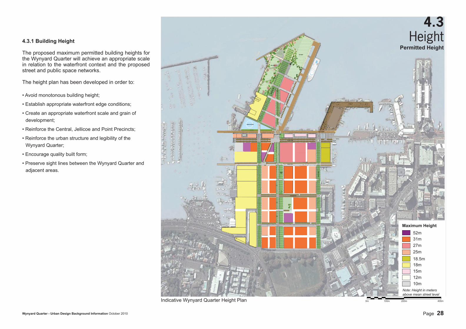
4.3.1 Building Height
The proposed maximum permitted building heights for the Wynyard Quarter will achieve an appropriate scale in relation to the waterfront context and the proposed street and public space networks.
The height plan has been developed in order to:
• Avoid monotonous building height;
• Establish appropriate waterfront edge conditions;
• Create an appropriate waterfront scale and grain of development;
• Reinforce the Central, Jellicoe and Point Precincts;
• Reinforce the urban structure and legibility of the Wynyard Quarter;
• Encourage quality built form;
• Preserve sight lines between the Wynyard Quarter and adjacent areas.
4.3Height
Indicative Wynyard Quarter Height Plan
Permitted Height
0m 100m 200m 400m
52m31m27m25m
18m15m12m10m
Maximum Height
18.5m
Note: Height in metersabove mean street level