vecmap brochure large v5c - business.esa.int brochure v5c.pdf · vat: be474372065 – iban: be29...
TRANSCRIPT

Risschotlei33,2980ZoerselBelgium–www.avia-gis.comVAT:BE474372065–IBAN:BE29320013831664–BIC:BBRUBEBB200
VECMAPTargetedsurveillanceandcontrolofdiseasevectors
VECMAP®isaproductbyAvia-GIS
VECMAP®isdevelopedinpartnershipwithERGOLtd(Oxford,UK)andMEDES(Toulouse,France)VECMAP®integrateseRiskMappercopyright©2011,OxfordUniversityInnovationLtd(Oxford,UK)VECMAP®wasco-fundedbytheIntegratedApplicationsProgram(IAP)oftheEuropeanSpaceAgency(ESA-ESTEC)(Noordwijk,Netherlands)

Risschotlei33,2980ZoerselBelgium–www.avia-gis.comVAT:BE474372065–IBAN:BE29320013831664–BIC:BBRUBEBB200
1 WhatisAvia-GIS?Avia-GIScreatesuser-friendlysystemsthatcanmodelbiologicalphenomena,especiallythedistributionandspreadofvector-bornediseases.Itisaworldleaderwithadistinctivenicheatthejunctionofspacetechnology,informationtechnology,ecologyandepidemiology.BornfromtheacronymofAgricultureandVeterinaryInformationandAnalysis,combinedwithGeographicalInformationSystems,wasfoundedbyitsCEOGuyHendrickxbasedon13yearsoftsetsecontrolactivitiesinAfrica.Establishedin2001,Avia-GIShasgrowntoemploy15people,mostofwhomarebio-engineers,biologists,veterinariansandITspecialists.Furtherexpansionisunderway.Thecompanyusesarangeofsatellitedataforitswork,mostnotablyfromNASA’sMODIS(ModerateResolutionImagingSpectroradiometer)sensors,apairofinstrumentsthatsurveythewholeoftheEarthevery24to48hours.Avia-GIShasbeensupportedinitsdevelopmentbytheEuropeanSpaceAgency(ESA).ESAregardsitasanimportantpartofthefast-growingEuropeanindustrydedicatedtodevelopingnewusesforspacedata.Overtime,itislikelytousemorecontentfromtheESA’sSentinelsatellites,whichareakeypartoftheEuropeanprojectofGlobalMonitoringforEnvironmentandSecurity(GMES).Inadditiontoitsworkindiseasevectormapping,Avia-GISisactiveinanimalhealthmonitoring.Ithasdevelopedarangeoftoolstoenhancetheuseofspatialmodelsbyveterinaryauthoritiesandindividualveterinarypractitioners.
2 VECMAP:theone-stop-shopVECMAPhascomeontothemarketatexactlytherighttime.Thevectorsthroughwhichanimal,plantandhumandiseasesspreadaroundtheworldarebecomingmoremobile.Thecausesofthischangearecomplex,multifaceted,andwillnotbeeasilyreversed.Thegrowthofworldtradeandinternationaltravelhasopeneduproutesfordiseasevectorstoreachnewterritories,suchasthetigermosquitoworldwide.Inaddition,growingleisuretimespentoutdoorsinthedevelopedworld,andtraveltothetropics,meansthatthereismorescopeforpeopletocomeintocontactwithdiseasevectors.ThespreadofLymeDisease,abacterialinfectionwhosevectorisatickwhichisparasiticupondeerandotherhosts,isawell-knownexample.Andofcourse,finallyglobalwarmingisincreasingtheriskoftheintroductionofnewpathogensinlocalornewlyestablishedvectorpopulations.Examplesincludebluetongueinruminants,andchikungunyaandzikavirusinhumans.Thisnewthreattohumans,animalsandcropscallsformanagementwhichisbasedonaccurateriskassessment.However,mappingthepresenceofanovel

Risschotlei33,2980ZoerselBelgium–www.avia-gis.comVAT:BE474372065–IBAN:BE29320013831664–BIC:BBRUBEBB200
diseasevectorinthewildisacomplex,multi-stagedtask.Ifitisnotdoneright,themappingwillfailtoproduceinsightsformanagementandpolicy.Forexample,awealthofaccurateinformationisneededtodriveaneffectivesurveillanceoreliminationprogramme.VECMAPsolvesthisproblembysupportingeverystageofthevectormappingprocessfromplanningasurveillancecampaign,toimplementingitontheground,analysingthespeciesdetected,mappingtheminthecontextofthelocalenvironment,andgeneratinganalysesthatcanbeusedtovisualiseandmanagethespreadofnoveldiseasevectors.VECMAPisafullyintegratedsystemwhichreplacesarangeoffreeandpaid-forsoftwarewhichtypicallycarriesoutonlypartofthecomprehensiveworkflowitcontains.Inaddition,fieldworkisexpensiveandoftentime-limited,butVECMAPallowscollectingcampaignstobeoptimisedsothatwastefulover-samplingisavoided.
3 ThefourcomponentsthatmakeVECMAP
Figure1-VECMAP4Components
VECMAPisunderpinnedbyfourkeytechnologies(Fig.1).
Risschotlei33,2980ZoerselBelgium–www.avia-gis.comVAT:BE474372065–IBAN:BE29320013831664–BIC:BBRUBEBB200
3.1 VECMAPAdministratorTheVECMAPAdministrationtoolisthemechanismdrivinganyVECMAPproject,andensuresitsprogressandtimelycompletion.Whilstprojectmanagementisahighly-developeddiscipline,theVECMAPapproachisuniquelysuitedtoprojectsbasedinboththefieldandthelaboratory,whichneedtobemanagedindistinctbutoverlappingstages.ThetoolisessentialtosetthebasisforallVECMAPoperationalactivities.Itrecognizesindividualsasadministrators,managersorprojectstaff,withvaryinglevelsofaccess.Itallowsfieldworkers,laboratorytechniciansandGISoperatorstobeassignedtotheprojectattherighttimeandplace.Itsexistencemeansthattime-consumingandcomplexprojectmanagementtasksareautomatedandoptimized.Projectteamsormembersaretrackedinnear-realtimesothatproblemscanbedealtwithastheyoccur.Onceyoursystemhasbeenset-upandresponsibilitieshavebeenassignedbytheadministratorofyourteam,workcanstart!
3.2 VECMAPGISAnotherkeyinnovationisVECMAPGIS,adesk-basedGISsystemforgeneratingsamplingstrategies,conductingspatialanalysesandcomputingspatialmodels.ItreliesupontheavailabilityofdetailedGISdataontheareabeingsampled,andontheuseofsophisticatedstatisticalknowledgetodesignsamplingstrategiesusingonthebasisofstratifiedmodelsofvectorhabitats.Thisknowledgeallowsfieldteamstobeallocatedspecificsamplingpointsonamap.ItalsoretrievesfielddataforthecentralVECMAPdatabase,andgeneratesmapsandotherdatatoguidefieldworkandtrackprogress.TheGISplatformincludespre-programmedtoolsthatallowsamplesizesandotherkeyaspectsofthecampaigntobeplannedautomatically.Oncefielddatahavebeenstored,toolsareavailabletoanalysespatialpatterns,prepareforspatialmodellingandcomputemodeloutputs.
3.3 VECMAPMobileCrucially,thequalityofthefinalanalysisderivedfromanyVECMAPprojectdependsontheinputdataobtainedbyfieldwork.VECMAPMobilerecognisestheimportanceofaccurate,complete,timelyandstatisticallyvalidsampling,andensuresthatprojectqualityismaintainedandprojecttargetsaremetinthefield.VECMAPMobilecanbeimplementedviatabletcomputersormobilephones.WhileVECMAP’splanningandanalyticalpoweraredependentuponGISdata,fieldtechniciansneedmoretraditionalmapstocarryouttheirsampling.

Risschotlei33,2980ZoerselBelgium–www.avia-gis.comVAT:BE474372065–IBAN:BE29320013831664–BIC:BBRUBEBB200
VECMAPMobiledownloadsthemapsandothermaterialsthatthefieldoperatorneedstocarryoutthesurvey.Inthefield,itstoresdataofflineandchecksitforvalidityasitisentered.AsthedescriptionofsteptwoofaVECMAPprojectexplains(seefurther),VECMAPMobileenablesdataandspecimenstobegatheredinawaythatisentirelyunambiguous,andwhichproducesreliableandcost-effectivesurveyresults.ThedataisuploadedtothecentralVECMAPdatabasewhenthedeviceisreconnectedtotheinternetforsecureaccessiblestorage.
3.4 VECMAPLabThefinalkeytechnologythatunderliesVECMAPisVECMAPLab.ThisaspectofVECMAPtechnologyiswheresurveysamplesareidentified,andenteredintothecentraldatabasebytechniciansworkingwithlabsheetsthatallowkeydata,suchasspecies,sexandabundance,tobestored.Again,everyrecordistiedtothetimeandplaceatwhichitwascollected.
4 DiseasevectormappinginjustsevenstepsOnceyoursystemhasbeenset-upandresponsibilitieshavebeenassignedbytheadministratorofyourteam,workcanstart!
Figure2-VECMAP7Steps

Risschotlei33,2980ZoerselBelgium–www.avia-gis.comVAT:BE474372065–IBAN:BE29320013831664–BIC:BBRUBEBB200
TherearesevendistinctstepstoanyvectormappingprojectinvolvingVECMAP.VECMAPisdesignedforusebyexpertsinfieldssuchasentomology,biodiversity,epidemiology,forestryandagriculture.Butitdoesnotrequireexpertknowledgeofremotesensingorspatialmodellingtouse.Inaddition,Avia-GISprovidesaservicetobridgeknowledgegapsatanystageofVECMAPimplementationandtoensurethateachmappingprojectisasuccess.
4.1 Stepone:planningthesamplingstrategyThefirstofthesevenstepsistodeviseasamplingstrategy.Thiswillvaryaccordingtoenvironmentalconditionsandthevectorbeingresearched.Inaddition,VECMAPcanadapttoarangeofbudgetsandtotheavailabilityofskilledfieldworkers.Itthenselectssamplesitesrandomlywithinselectedstrataandallocatesthemtoindividualfieldteamsorworkers.ThisstageofVECMAPinvolvesautomatinganareaofprojectdesignthatwaspreviouslytime-consumingandcomplex.Optimisingthisprocessalsomeansthatresourcesareusedtobesteffectduringthefieldandlaboratorystagesofthetask.UserscanbeconfidentthatusingVECMAPwillsavetimeandmoney,andincreasethestrengthoftheprojectconclusions.
4.2 Steptwo:fieldworkThissecondstepmightseemthemosttraditional:thegatheringoffielddata.However,VECMAPre-imaginesbiologicalfieldworkbymeansofanautomatedapproach,whichagainreducescostsandincreasesaccuracyandcertainty.EachfieldworkerhasasmartphoneortabletwhichissyncedtothecentralVECMAPdatabase.AsaGPS-connecteddevice,itknowswhereitis.Inthiswayeveryobservationorsamplecollectioncanbelocatedprecisely.Italsocontainspreciseinstructionsforthefieldoperator,tellingthemexactlywhattolookfor,wheretolookforitandwhattorecord.Avia-GIScanprovidetrainingforthefieldteam,orhelptorecruitexpertsforthispartoftheproject.Inaddition,thedevicecanbeusedtorecordenvironmentalconditionsandtakephotographs,producingadensedigitalrecordofthesettinginwhichspecimensaretaken.Finally,thesystemalsoallowsuserstoswipebarcodesonthecontainerscontainingspecimens,givingapreciserecordofwhenandwheretheywerefound.
4.3 Stepthree:specimenidentificationOncethefieldworkhasbeencarriedout,theactionmovesfromthefieldtothelaboratory.Herespecimensareidentifiedandallinformationisstoredcentrallyinoneplace,theVECMAPdatabase.VECMAPensuresthecorrectclassificationofidentifiedvectorsbyprovidinganupdatedtaxonomy,aswellastrainingin
Risschotlei33,2980ZoerselBelgium–www.avia-gis.comVAT:BE474372065–IBAN:BE29320013831664–BIC:BBRUBEBB200
identificationifrequired.ManyVECMAPusersareexpertsinentomologyandtheotherareasofbiologyneededforthistask.However,partoftherationaleforVECMAPisthatoftenlittleisknownaboutdistributionlimitsofindigenousspeciesandnewandinvasivespeciesareontheriseandneedtobemapped.WehavedevelopedtrainingintheidentificationofnovelspeciesthatisavailablefromAvia-GIS,ifrequired.
4.4 Stepfour:monitoringandmanagementAtthisstage,VECMAPswitchestotheroleofoverallprojectmanager.Itnowcomparestheprogressmadewithfieldworkandspecimenidentificationtotheoriginalprojectplanandassessestheoutcomesofthefirstthreesteps.Here,VECMAPrunscomparativemanagementanalysisofthestudysitesthathavebeenselectedandassignedtoteams,combinedwiththegeolocationofthesitesvisitedbyfieldteams,andsynchronisesitsfindingswiththecentraldatabase.Finally,thespecimenscollectedwillhavebeenidentifiedandthelabresultsstoredinthecentraldatabase.Atthispoint,VECMAPallowsprojectmanagerstodeterminewhetherthereareanypartsoftheprojectthatareshowinginefficienciesintermsoftime,resourcesandspend.Thisallowsreminderstobesentandresourcestobereallocated.ManyusesofVECMAPareurgent,perhapsbecausetheyinvolvethevectorofadangerouspathogen.Sotherearestrongerreasonsthaninconventionalprojectmanagementforittostayontrack.Inaddition,keepingtotimemeanskeepingtobudget,andavoidsexcessivedemandsonthetimeofscarceprofessionals.
4.5 Stepfive:datasharingStepfiveofaVECMAPprojectistheonlystepinwhichparticipationisoptional.ItiscurrentlyunderdevelopmentandwillbeavailableaspartofVECMAPV2.0.AllVECMAPdataisheldinasecuredatabasethatisprotectedtoglobally-acceptedhighstandards.However,thereisagrowingVECMAPcommunitywhosemembersareabletosharedataorworkonprojectscollaborativelyonanagreed,opt-inbasis.IfanumberofVECMAPclientscollectdataonthesamevectorinagroupofnearbyregions,forexample,itmightmakesenseforthemtoexchangeandcomparewhattheyhavefound.TheuseofVECMAPsimplifiesthiscooperationbecauseitholdsdatainastandardformatthatallowseasycomparison.Thedatacanbecomparedanonymously,andtherearealreadycaseswheredataexchangeisimprovingfieldwork-basedmodelsofvectordistribution.Avia-GISintendsto

Risschotlei33,2980ZoerselBelgium–www.avia-gis.comVAT:BE474372065–IBAN:BE29320013831664–BIC:BBRUBEBB200
developitsusercommunityinfutureyears,andencouragemorecommunityinteraction.
4.6 Stepsix:spatialanalysisThesixthstageofVECMAPiskeytoitsimportance.Itinvolvesaddingvaluetofielddataandturningitintoafullanalysisofspatialdistribution.Inthisspatialanalysisphase,fielddataisusedalongsideenvironmentaldatafromVECMAPresources,aswellaspublicdataontemperature,rainfallandothervariables,tofindoutwhatdrivesspeciesdistributionoverthesurveyregionasawhole.Itispossibletovisualiseandquerythefindingsinawidevarietyofways.ThisphaseofaVECMAPprojectregularlyseesnewinsightsemerging.
4.7 Stepseven:spatialmodelling
TheseventhandfinalphaseofVECMAPisspatialmodelling.Itisthepointatwhichthedisparatedataaregatheredtogethertobecomeusableknowledge.Inturn,thisprocessaffordsanevidence-basedresponsetoaspecificdiseasevectortobedeveloped.Here,thespatialanalysisfromstepsixisusedastheinputforspeciesdistributionmodelsthataredevelopedviaawiderangeofstatisticalmethods.Thesemodelsarepredictive.Theycanfillindistributiongapsandpredicttheprobableoccurrenceandabundanceofspeciesinsquaresonthemapwherenosamplinghastakenplace.VECMAPisnotyetaforecastingmachine.Initspresentform,itcannottelltheuserwhereaparticularspecieswillbefoundoverthecomingyears.Instead,themodellingphaseexplainswhatdrivescurrentandfuturespeciesdistribution,andprovidestheevidencebaseforriskanalysis.ThisallowsinsightsgeneratedbyVECMAPtobeusedindesigningsurveillanceprogrammes,ortodevelopcampaignsdirectedattheeliminationofnewandunwelcomediseasevectors.TheexampleoftheAsianBushMosquitoinBelgium(pageXX)showsthissuccessfulforwardlookingapproachinaction.
5 ThefourVECMAPflavoursVECMAPisaone-stop-shopforanyonewantingtoknowhowadiseasevectormightspreadandwhatcanbedoneaboutit.Aswithallthebestshops,thereisavarietyofpricesandflavoursonoffer.
5.1 VECMAPLiteVECMAPLitev1.0isaFreeversionofVECMAPwhichisintendedprimarilyforPhDstudents.Itessentiallyallowsanexistingdatasettobeordered,queriedand

Risschotlei33,2980ZoerselBelgium–www.avia-gis.comVAT:BE474372065–IBAN:BE29320013831664–BIC:BBRUBEBB200
analysed,andcontainsthebulkofthecapacityofsteps6and7oftheVECMAPworkflow,includingaselectionofitsmostusefulmethodsforspatialanalysisandspatialmodelling.VECMAPLiteonlyprovidesaccesstotheVECMAPGIScomponent,anddoesnotcontainthefullprojectplanningandimplementationcapacityofthecompleteversion.Itisrestrictedinthevolumeofdataitcanmanage,andisintendedforusewithsamplingdatathatisalreadyavailable.Itcanbeobtainedforfreeuponcompletionofaquestionnairewhichhelpsauthenticatetheuserandhis/herprojects,whichallowsAvia-GIStoimproveitsproductthinking.Toavoidlongdownloadtimes,thesoftwarecanbesentbysurfacemailonaUSBstick.ItcanalsobeobtainedatoneoftheVECMAPon-tourworkshops,orataconferencedirectlyfromAvia-GIScollaborators.TheschedulefortheseeventscanbefoundontheVECMAPwebsite.
5.2 VECMAPPremiumThefullfourcomponentandseven-stageversionofVECMAP1.0existsasamulti-userversionandisspecificallydesignedforimprovingteamwork.VECMAP®PremiumversionallowsauthoriseduserstoaccessdatasetsandtheVECMAPdatabase,receivetrainingmaterials,consultFAQsandhaveaccesstothehelpdesk.InadditiontothestandardisedsatellitedatasetthatiscommontoallVECMAPimplementations,Avia-GIShasaccesstoawiderangeoffreeandpaid-fordataincludingenvironmental,politicalandotherdatasets.Thisversionhastwomaintenanceoptions:TheFull-fledgedYearlyMaintenance&theStandardYearlyMaintenance.TheFull-fledgedYearlyMaintenanceincludes,ontopofwhattheStandardonehas:fullhelp-line&technicalsupport,andupdatedEO(EarthObservation)dataset.TheStandardYearlyMaintenanceoption,ontheotherhand,islimitedtoSoftwareupdates,theVECMAPcentraldatabase,andaccesstotheVECMAPprivatecommunity.Atanytime,thecustomerwiththeStandardYearlyMaintenancecanpurchasetechnicalsupportbundlesandtheEOdataset.SuchflexibilityreflectsthecustomercentricaffiliationAvia-GIShastowardsitscustomers.
5.3 VECMAPExpertThissingle-userversionofVECMAP®isaimedatindividualresearchersorsmallerpestcontrolcompanieshavingapermanentactivityinvolvingspeciesmappingwhorequireandneedtoplan,collect,analyseandmodeldata.Asforthepremiumversion,itgivesfullaccesstothefourcomponentsandsevenoperationalsteps.

Risschotlei33,2980ZoerselBelgium–www.avia-gis.comVAT:BE474372065–IBAN:BE29320013831664–BIC:BBRUBEBB200
5.4 VECMAP®ModellingThisstand-aloneversionofVECMAP®(i.e.notlinkedtothecentralVECMAP®database)isthelatestVECMAP®FlavourdevelopedbyAvia-GISinresponsetoacleardemandfromthemarket.Itonlyprovidesaccesstothetwolastoperationalsteps:spatialanalysisandmodellingandassumesthattheclienthasaccesstoalltherequiredvectordistributiondataheorshewantstoanalyseandmodel.Itrespondstoaclearrequestfromthemarket.
Inadditiontothe4classicflavours,VECMAPisalsoavailableasaServiceusingAvia-GIS’sowntechnicalpersonnel,trainingandcomputingresources.Thisapproachinvolvesthecompanybecomingpartnerofafundedresearchprojectwithanegotiatedbudget.
6 VECMAPsuccessstories
6.1 BeatingBelgium’smosquitoes**
“MODIRISKwasauniqueopportunitytoapplytoEuropethemethodsIdevelopedinAfricaandtosetthesceneforVECMAP–GuyHendrickx,CEOAvia-GIS”
Today’sVECMAPhasitstechnicalandintellectualrootsinmethodswhichthefounderofAvia-GISdevelopedinTogo,WestAfrica,formappingtsetseflies,theirhostsandthediseasestheytransmittomanandlivestock.InBelgiumheinitiatedMODIRISK,aBelsporesearchprojectsetuptomapmosquitodiversityinBelgiumandtheNetherlandsasitbecameapparentthatthisknowledgewasessentialtoassessingtheriskposedbynewmosquito-bornepathogens.Asetofprecursortoolsweredevelopedtocoordinatearea-widesamplingandmanagefieldteamsfromthreeInstitutions:TheInstituteforTropicalMedicineinAntwerp,theNaturalHistoryMuseuminBrussels,andtheUniversitéCatholiquedeLouvaininLouvain-la-Neuve.AfirstinBelgianandEuropeanresearchhistory!

Risschotlei33,2980ZoerselBelgium–www.avia-gis.comVAT:BE474372065–IBAN:BE29320013831664–BIC:BBRUBEBB200
Figure3-CulexpipiensdistributionmodelsforBENELUXusingdecreasingsamplesizes
Aspartoftheproject,1,000samplingsiteswerevisitedduringtwovectorseasons,eachdividedintotwosamplingperiods.Asaresult,22mosquitospecieswereidentified.Twowerefirst-timerecordsofinvasivespecies,14couldbemodelledandsixwerecategorizedasveryrare.ThisyieldedacompletepictureofmosquitodiversityinBelgiumata1x1kmresolution.
Figure4-VectorcontroloperationsagainstAedesjaponicusinNatoye(Belgium)
From2013to2015,VECMAPwasusedinveryhigh-resolutionmodetotrackthepresenceoftheinvasiveAedesjaponicusmosquito,andtoplan,implementandassessthesuccessofaneliminationprogramme.ThiswascarriedoutincollaborationwithpublicserviceorganisationsinWallonia,andwiththeassistanceoflocalcommunitiesinthevillageofNatoyeanditssurroundings.ThesitesselectedbyVECMAPweresurveyedbetweenMayandOctoberin2013and2014,usingspecifictrapsforadultsaswellascollectionstrategiesforlarvae.Eachpotentialbreedingsitewasthentreatedwithbiocide,cleaned,orremovedcompletely.FollowingthistherewasnopositivetrappingofthisinvasivemosquitoafterAugust2015,againafirstforBelgiumandEurope!
Risschotlei33,2980ZoerselBelgium–www.avia-gis.comVAT:BE474372065–IBAN:BE29320013831664–BIC:BBRUBEBB200
TheWalloniaprojectwasdrivenbypoliticalawarenessthatAedesjaponicus,aninvasivespecieswithapotentialimpactonpublichealth,hadrecentlycolonizedtheregion.ThesurveycentredontheareaaroundNatoye,whereused-tyrebusinesseswereprovidingafootholdformosquitoesintheformofactiveimportandbreedinggrounds.TheuseofVECMAPallowedthespeciesdistributiontobepreciselydefined.Suchanapproachcanleadtoariskanalysisofvaluetogovernmentsandpolicymakersaswellastohealthservices.
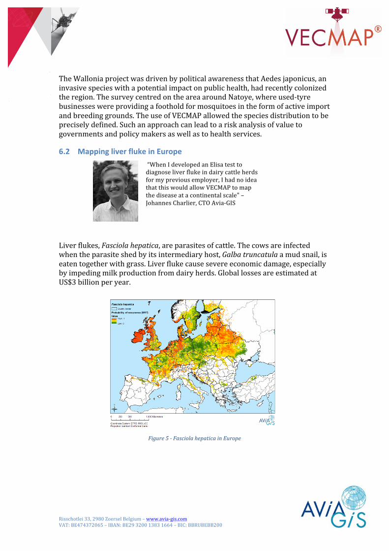
6.2 MappingliverflukeinEurope
“WhenIdevelopedanElisatesttodiagnoseliverflukeindairycattleherdsformypreviousemployer,IhadnoideathatthiswouldallowVECMAPtomapthediseaseatacontinentalscale"–JohannesCharlier,CTOAvia-GIS
Liverflukes,Fasciolahepatica,areparasitesofcattle.Thecowsareinfectedwhentheparasiteshedbyitsintermediaryhost,Galbatruncatulaamudsnail,iseatentogetherwithgrass.Liverflukecausesevereeconomicdamage,especiallybyimpedingmilkproductionfromdairyherds.GloballossesareestimatedatUS$3billionperyear.
Figure5-FasciolahepaticainEurope

Risschotlei33,2980ZoerselBelgium–www.avia-gis.comVAT:BE474372065–IBAN:BE29320013831664–BIC:BBRUBEBB200
ThepresenceofliverflukehasbeenmappedundertheEUFP7GLOWORMproject,whichoperatedinfivecountriesfromIrelandtoPoland.Thefieldworkandsamplingphaseoftheprojectwasanunusualone.Itisnotnecessarytohuntforthesnailintheopenairtodetermineitspresence.Instead,cattlewithliverflukeinfectionproduceantibodieswhicharedetectableintheirmilk.Samplingthetanksinwhichmilkiscollectedonfarmsallowsthewholeherdtobesampledandshowsthepresenceofbothflukeandsnailsinpasture.Theprojectsampled3,359tanksinall.ThisapproachenabledVECMAPtoproducethefirstEuropeanriskmapforliverfluke,auniquedataproductwhichhasarangeofuses.Itisobviouslyofpolicyandresearchinterest,asitshowsthelocationoftheecologicalandclimateconditionsthatthevectorprefers.Butithasalsobeenusedtodrivebusinessstrategyintheanimalhealthindustry.Themapsallowbusinesseswhichhavedevelopednewtreatmentsforliverfluke,tosendtheirsalesforcetotheareasofhighestrisk,havingafullyscientificbasisfortheirefforts.Inaddition,theanalysisproducedbyVECMAPinthisprojectcanbesupplementedbymoregranularinformationwhichisofusetoindividualfarmers.Theone-kilometresquaresonwhichmostVECMAPstudiesarebasedaretoocoarseforittobeatoolforpasturemanagement.Andwhilemoredetailedsatellitedataisavailable,usingitasaninputtoVECMAPcanmeanunacceptablylongrunningtimesforthemodeltoresolve.
Figure6-Pastureriskmodelbasedondroneimagery.
However,inthecaseofliverfluke,itwaspossibletosupplementVECMAP’sinsightsatacontinentalandcountryscalewithdatagatheredbydrones,whichofferresolutionsofafewcentimetres.Thisapproachallowedhotspotstobeidentifiedinproblemfarmswherecattleandsnailsareespeciallylikelytocome

Risschotlei33,2980ZoerselBelgium–www.avia-gis.comVAT:BE474372065–IBAN:BE29320013831664–BIC:BBRUBEBB200
intocontact.Avia-GIScanthenhelpthefarmertodecidewhatstepsmighthelpmanagetheriskatfarmlevel,perhapsbydrainingmarshyareasofpasture.
6.3 Managingdiversevectordatabases
“AscoordinatorofVectorNet,VECMAPisanessentialtooltoidentifygapsinmapsandtoplanadditionalfieldsurveysforavarietyofvectorspeciesthroughoutEurope"–VeerleVersteirt,COOAvia-GIS
Theliverflukecampaigndiscussedaboveshowsthatwecanimprovediseasecontrolbythinkingaboutdiseasevectorsonabroadscale.Todothis,alldataonavectorofinterestneedstobeavailableonacomparablebasis.VBORNETanditsfollow-upnetworkVectorNetputthispossibilityintopractice.Thenetwork,runbyAvia-GISfortheEuropeanCentreforDiseasePreventionandControl(ECDC,Stockholm,Sweden),nowjoinedbytheEuropeanFoodSafetyAuthority(EFSA,Parma,Italy),collectsPan-Europeandataonavarietyofpotentialdiseasevectorsincludingmosquitoes,ticks,sandfliesandbitingmidges,fromarangeofsources,integratesitintoacommonformat,andidentifiesgapsincoverage.Itthenplansthesurveyworkneededtocoversignificantgapscost-effectively.
Figure7-Exampleofvectordistributionmapproducedonathree-monthlybasisbyVectorNetusingAvia-GISsoftware
WhiletheentryandqualitycontrolofvectordataintheECDCdatabasesisperformedwithaspecificon-linetooldevelopedbyAvia-GIS,themodelling,gapanalysisandfieldworkplanningareachievedusingVECMAP.

Risschotlei33,2980ZoerselBelgium–www.avia-gis.comVAT:BE474372065–IBAN:BE29320013831664–BIC:BBRUBEBB200
Figure8-ExampleofGAPanalysisusingVECMAP
ManyexpertsandorganisationsinEuropeandbeyondholddataondiseasevectors.Theseincludemedicalentomologists,healthserviceprovidersaswellasgroupsconcernedwithecologyandtheenvironment.VectorNethelpsthemexpandtheirknowledgeandseethebiggerpicture.
7 ThepowerofVECMAPThesuccessstoriescitedasexamplesshowthatVECMAPcanhelpwithmanydifferentaspectsofvectorsurveillanceandcontrol.InthecaseoftheBelgianmosquitosurveys,VECMAPwasusedtoguidetheentireprocessofelucidatingandeliminatingathreatofunknownsize.Withliverfluke,thediseaseitselfwasalreadyfamiliar,aswasitsvector,buttheareasofgreatestecologicalandclimatehazardwerestilltobeestablished.Inbothcases,VECMAPwasusedtodesignasamplingstrategythatwouldtrackthevectorofinterestthroughtime.Incontrast,theuseofVECMAPwithVectorNetallowssurveystobecreatedandbroughttoausablelevelofcompletenessonthebasisofidentifiedgapsinexistingdatathatwouldotherwisehaveremainedincompatible.Inaddition,VECMAPisflexibleandcantakeonothertypesoffieldwork-basedprojects,suchasmeasuringbiodiversityorthespreadofotherinvasivespecies.Moreusesarelikelytoariseinfutureyears.