vanessa hearfield cv and projects 2015
TRANSCRIPT

V A N E S S A H E A R F I E L D
1 | P a g e
PERSONAL DETAILS
Contact Details 44 Woodridge Drive, Woodridge, Wellington 6037 04 478 2876 (home) 027 552 9708 (mobile) vanessa.hearfield (skype) [email protected] http://nz.linkedin.com/pub/vanessa-hearfield/21/869/574/
KEY TRANSFERABLE SKILLS
I am a Project Manager and Certified Scrum Master, who has worked across a range of organisations, both in New Zealand and the UK. Although my background has predominately been based on spatial applications, many of the solutions I have been responsible for managing and delivering are web applications, which may have included an embedded or integrated mapping component. This includes SilverStripe CMS and Framework, PHP, HTML5, Javascript, CSS, and .NET, including Silverlight. I have led and managed cross-functional teams that have comprised front-end and back-end web developers, Solution Architects, Database Administrators, Testers, GIS Consultants and GIS Analysts. I have also worked on multi-vendor projects, and engaged with distributed teams.
• Project Management and project lifecycles including Agile and Prince2 methodologies • Principles of development of web technologies including Silverlight and Javascript/HTML5 viewers and
applications, and infrastructure (hardware, databases, software installations) • Contract Management • Team Management, HR skills, training and development plans • Chairing and running meetings, including setting agendas, recording minutes and action points. • Documentation of processes, procedures, specifications, requirements, and user stories. • Quality Management practices • Communication of technical concepts into plain language, verbally and written • Expertise in Geographical Information Systems (GIS) including data capture, analysis, cartographic &
tabular output, and system management • Testing and QA including software, data, hardcopy maps, web viewers and user experience • Data Management, analysis & interpretation of a large variety of data sets and types including spatial
and textual • Proficient in all aspects of internal audit from a qualitative perspective • Client relations, Sales & Marketing, Client support and consulting • Design & development of training material, course delivery & user support documentation
INFORMATION TECHNOLOGY SKILLS
• Cloud-based business tools including Workflow Max, Harvest, Capsule CRM and Zendesk • Agile Tools such as Jira OnDemand, TargetProcess, RallyDev, Team Foundation Server, Basecamp and
Campfire • GoogleDocs and Google Drive
• Microsoft Project Professional and Project Server • Microsoft Office Suite including Visio • Microsoft SharePoint • Manage Engine Service Desk • GIS Systems & CAD including Esri ArcGIS suite, Latitude Geographics Geocortex Essentials, Pitney
Bowes MapInfo, Intergraph Geomedia and Bently Microstation

2 | P a g e
EMPLOYMENT HISTORY
August 2014 – November 2014 SilverStripe Limited Agile Project Manager/ScrumMaster – Platform Division
• Agile Project Manager for the internal development team (comprising 4 back-end php developers, two
front end developers, 3 designers and a tester) looking after, and working on, the SilverStripe
managed platform solutions, AWS and NZ Govt Common Web Platform (CWP), open source product
(framework and CMS) and SilverStripe sites (SilverStripe.com and SilverStripe.org). - Facilitation of all aspects of scrum for the project team, including running of sprint
meetings, backlog sizing, retrospectives and reviews. - Backlog refinement and user story creation and refinement, including obtaining
understandings of long term view and process - Generation of relevant metrics for project team, management and stakeholders - Communication with internal and external stakeholders and Product Owners - General Project Management for non scrum-based work streams
July 2010 – August 2014 NorthSouth GIS (NSG) (formerly Explorer Graphics Ltd EGL) Delivery Manager/Consultant Team Lead
• Member of the Executive Management Team, working towards improving the company in terms of culture, efficiency and profitability including:
- Collaborative working with other members of the Executive Management Team, and key staff members to identify areas of the business for improvement
- Introduction of new processes and workflows - Review and implementation of business tools, such as Harvest and Jira to streamline
workflows and become more efficient - Introduction of Agile methodologies, Kanban/scrum boards and sprint-based work
practices to support agile in a services-based environment - Staff training and engagement in order to obtain ‘buy-in’ for the changes - Production of materials for board reports
• Line Management for a geographically distributed team of ten, including GIS Consultants and Analysts, DBA, SysAdmin and Solutions Architect
- Undertaking regular staff appraisals, and identifying opportunities for training and improvement
- Development and implementation of staff training plans - Mentoring and supporting staff to develop their own Project Management skills and
to take ownership of running projects from end-to-end. • Manage a range of projects and work streams, using both Agile and Waterfall methodology. • Responsible for general project management tasks including:
- Stakeholder communications - Development and maintenance of project plans - Identification and monitoring of project risks and issues - Creation of all project admin related components including set up of SharePoint
project sites, timesheet codes and budget details, and contracts. - Provision of regular project status reports for internal and external use. - Project tracking including time, budget and task completion. - Responsible for client billing including analysis of time, cost and fixed fee milestones. - Compilation and management of project team and resources in order to meet project
timeframes and budget. • Undertake client liaison, requirements gathering, project scoping, business and relationship
development, and authoring proposals and statement of works. • Translate user requirements into tasks, and determine the resource requirements and estimates of
effort to determine cost and duration of projects. • Responsible for the assessment and allocations of Service Desk tickets, and monitoring of time against
support agreements.

3 | P a g e
September 2007 – July 2010 Parental Leave April 2005 – September 2007 ENGLISH HERITAGE DeskGIS Manager
deskGIS Implementation
• Managed successful migration & implementation of systems, data, users & processes - Worked closely with ESRI UK, EH ICT Department, Project Manager and EH GIS User
Community - Assisted EH Project Manager in identifying risks and issues and ensuring that all project
documentation around these was up-to-date, including Rick and Issue Logs, along with monitoring and maintenance of the Project Plan
• Developed & managed deskGIS testing programmes, including system, data & regression test scripts & documentation, & support for user testing
• Prepared & developed user support & training programs, including delivery of training courses, help-desk support, user documentation & workshops
- Ensured I understood individuals’ roles and how they would use GIS in order to provide tailored training and user documentation to teams and individuals, including the types of queries, data analysis and outputs they would require.
Business As Usual
• Undertook day-to-day management & monitoring of deskGIS, including creation of user statistics, figures & reports
- Prepared fortnightly and monthly reports on usage, user statistics, and status of helpdesk or support calls
• Effectively managed deskGIS user community requirements & expectations - Assessed requests for improvements to the system or bugs - Prioritised and specified any change requests or enhancements - Chaired quarterly deskGIS User Group Meetings, and provided deskGIS User Group with
regular updates and communications as required • Acted as a GIS specialist on numerous boards & user groups’ providing GIS advice and representing
GIS interests within the greater organisation, and representing English Heritage at external meetings and conferences
May 2002 – February 2005 CRITCHLOW ASSOCIATES LIMITED
GIS Project Consultant/Quality Manager GIS Project Consultant (80%)
• Provided Project Management for small and large mapping, data capture or analysis projects including determining customers’ needs & translating these into specifications, & proposals for works to be undertaken
• Calculated resource requirements & devised project plans • Provided GIS advice, training & support to customers as a variety of outputs including data analysis,
geocoding, data capture or manipulation, map production and web-based applications • Developed Quality Assurance plans & tasks, and undertake independent QA checks of peers work Quality Manager (20%)
• Maintained organisations ISO 9001:2000 certification • Maintained & updated Quality Management manual, procedures, processes & templates • Coordinated & reviewed Internal Auditing requirements • Prepared system for annual external certification audits • Provided training & assistance to staff on how to use the Quality Management system & what was
required of them
4 | P a g e
November 2000 – May 2002 PORIRUA CITY COUNCIL GIS Operator
• Performed data input, analysis & mapping services & quality assurance on demand for internal & external customers
• Developed & provided in-house training of software & systems • Maintained & updated the council’s property information, including data capture of new property
boundaries, house numbering, liaison with relevant government departments & links between spatial & textual databases
• Provided documentation on GIS systems & processes • Provided policy advice on issues relating to quality of data & data capture, particularly in relation to
address standards, property subdivisions, and preferred data formats within the organisation January 2000 – November 2000 TERRALINK INTERNATIONAL GIS Technician and Data Compiler (Photogrammetry)
• Developed proficiency in 3-dimensional data capture from aerial photographs for use in GIS systems, digital terrain modelling & orthophoto generation, adhering to strict specifications & tolerances
• Performed quality control & assurance March 1999 – December 1999 LAND INFORMATION NEW ZEALAND (LINZ) National Topographical and Hydrographic Authority (NTHA)
Assistant
• Developed understanding of Topographic database maintenance • Captured & converted place names, spot heights & contours to digital format of 1:50 000 Topographic
sheets June 1999 – Aug 1999 TERRALINK INTERNATIONAL Data Compiler (Project Based)
• Developed proficiency & understanding of 2-dimensional data capture of road centre lines & attribute data for the Wellington City Council RAMM database
• Performed quality checking & correction of peers work
EDUCATION & QUALIFICATIONS
2011 Certified Scrum Master (CSM) 2005 Prince2 Foundation 2004 Certificate of Quality Management
Wellington Institute of Technology, Wellington, New Zealand 1999 Bachelor of Science (BSc)
Geography and Environmental Studies Victoria University of Wellington, Wellington, New Zealand
5 | P a g e
OTHER TRAINING
Project and People Management
• Certified Scrum Master (CSM) • PRINCE2 Foundation Course • NZIM Project Management • Equinox IT Agile 101 Using Scrum & XP • Equinox IT Hands-On User Stories Workshop • Equinox IT Agile Estimating & Planning • Equinox IT Effective User Stories for Agile Requirements • ITIL People Management Made Easy
GIS
• Latitude Geographics Creating Viewers and Sites with Geocortex REST Technologies • ESRI (UK) Building Geodatabases • ESRI (UK) Advanced Editing • ESRI Virtual Campus Learning ArcGIS I & Learning ArcGIS II: Presenting Information • ESRI Virtual Campus Editing in ArcGIS 9 – Tips & Tricks I • MapInfo Professional Introductory Training • MapInfo Professional Advanced Training • MapInfo MapBasic Introductory Training • MapInfo Vertical Mapper Training • MapInfo MapShop Training • Intergraph MGE Users Training
Personal Development
• Dale Carnegie 12-week Personal Development Programme • Dale Carnegie High Impact Teams
Quality Management
• Internal Certifications Limited (ICL) Internal Auditor Training Computer Programming
• Weltec Introduction to Visual Basic (part-time non-assessed) Microsoft Office
• Advanced Word & Template Creation • MS Project
Other
• Zendesk Bootcamp • Better by Design – Experience Design Led Thinking
PERSONAL INTERESTS
Skiing, Mountain biking, running, cooking, reading, travel, spending time with my family. I am also a member of the Paparangi School Board of Trustees, and the Agile Welly Meetup group.
EMPLOYMENT REFERENCES
Available on Request

P R O J E C T A D D E N D U M
6 | P a g e
FEATURE PROJECTS
Ballance Agri-Nutrients Ag Hub Map Manager September – December 2013 http://www.aghub.co.nz/our-solutions/ballance-shareholder-offer Ag Hub is a modular cloud-based farm and nutrient management tool, developed for Ballance Agri-Nutrients. Map Manager is an HTML5 map viewer that has been developed using Latitude Geographics Geocortex Essentials HTML5 viewer technology and is a combination of out-of-the-box functionality and bespoke tools. The primary function of Map Manager is to provide Ag Hub users the ability to create and edit their own farm maps. The mandate was to make an application that is simple to use, with minimal steps required by the user, and this brief was met through the map viewer. Behind the scenes, the solution is much more complex and NSG was required to integrate Esri ArcGIS Server with SAP through the use of web services, as well as design and implement a complex security model that would restrict users access to only the records relevant to them. This was a complex project both in terms of the overall solution, and management of the delivery as at times there were multiple vendors involved in the delivery of the entire solution. My main responsibilities were the Project Management of the NSG components, communications with the client and other vendors including regular progress review and meetings and demos, requirements scoping, overseeing and development of test plans and contract management. NSG utilised components of agile methodology, mainly iterative development cycles and regular client reviews and demos to ensure that the deliverables met the client’s expectations and requirements. LINZ Forward Works November 2013 – July 2014 http://www.forwardworks.co.nz The Forward Works Viewer was a multi-vendor project designed to deliver a web-based planning tool for vertical and horizontal building and infrastructure projects in the Canterbury Earthquake rebuild. It was initiated and driven by LINZ, and was an agile-run project spanning 8 months. NSG was involved in the delivery of the GIS infrastructure and hosted environment, user and access security, data migration and management, map viewer and bespoke development of map viewer tools and back-end processes. In the early stages of this project I was involved in overseeing the delivery of the NSG components, providing agile coaching and support to the NSG development team, especially at the daily stand ups, sprint planning, review and retrospective meetings, assisting with requirements specification and documentation, and ensuring the NSG development team were able to work without impediment. As the project progressed, and the team became more skilled up and familiar with the agile process, my day-to-day involvement reduced to the point where my main tasks are providing general Project Management tasks such as budget and time tracking and invoicing. Hutt City Council Request for Service (RFS) April – May 2014 https://gissecure.huttcity.govt.nz/RAP/viewer/ Hutt City Council (HCC) wants to improve the quality of RFS data being recorded through their web form and contact centre, as well as provide the ability for citizens to log requests from 'out-in-the-field' using smartphones and mobile devices. The end-solution needs to be fast, both in terms of usability and response time. The solution is a web form with an Esri Javascript map embedded, that contains a number of tools (address search, geolocate, point and click) to assist with pinpointing the location of the RFS. The web form integrates with Confirm - Hutt City Council's Request Management System - as well as their Esri ArcGIS Server and ArcSDE database. This project has been run in an agile manner by using spikes to determine feasibility of different solution options, development milestones determined by sprint, as well as iterative delivery and demos to the client to ensure the solution meets their requirements and expectations. The final solution for Phase 1 of

7 | P a g e
this project is currently with the for their final acceptance testing. Once this is complete, Phase 2 will commence which will comprise full integration between Confirm and ArcSDE, and release to the public for use. This is expected to occur within the next two months. My responsibilities on this project were managing client relations and meetings, working with the client on the development and refinement of the specifications, estimation of time and budget, contract management, high-level design of the web form, and overall responsibility for the delivery and milestones. Porirua Pathfinder November 2013 – February 2014 http://gis.pcc.govt.nz/pathfinder/ Porirua Pathfinder is an HTML5 web application designed to provide access to information about walkways and recreation opportunities within Porirua City. The solution is build using Latitude Geographics Geocortex Essentials HTML5 viewer, and is a combination of out-of-the-box tools and bespoke development to provide a simple to use mobile-enabled web-based solution. The project was run using concepts of agile methodology, and was run in an iterative manner, with regular client reviews to ensure the solution being developed met the clients needs and expectations. My main responsibilities on this project were the development of the solution specification, input into the data model and logic, user experience and usability, development of test plans and test scripts, and assistance with testing the solution across a range of devices and technology platforms. I also performed general project management tasks such as contract development, time frame and price estimation, budget and milestone tracking and delivery management.
8 | P a g e
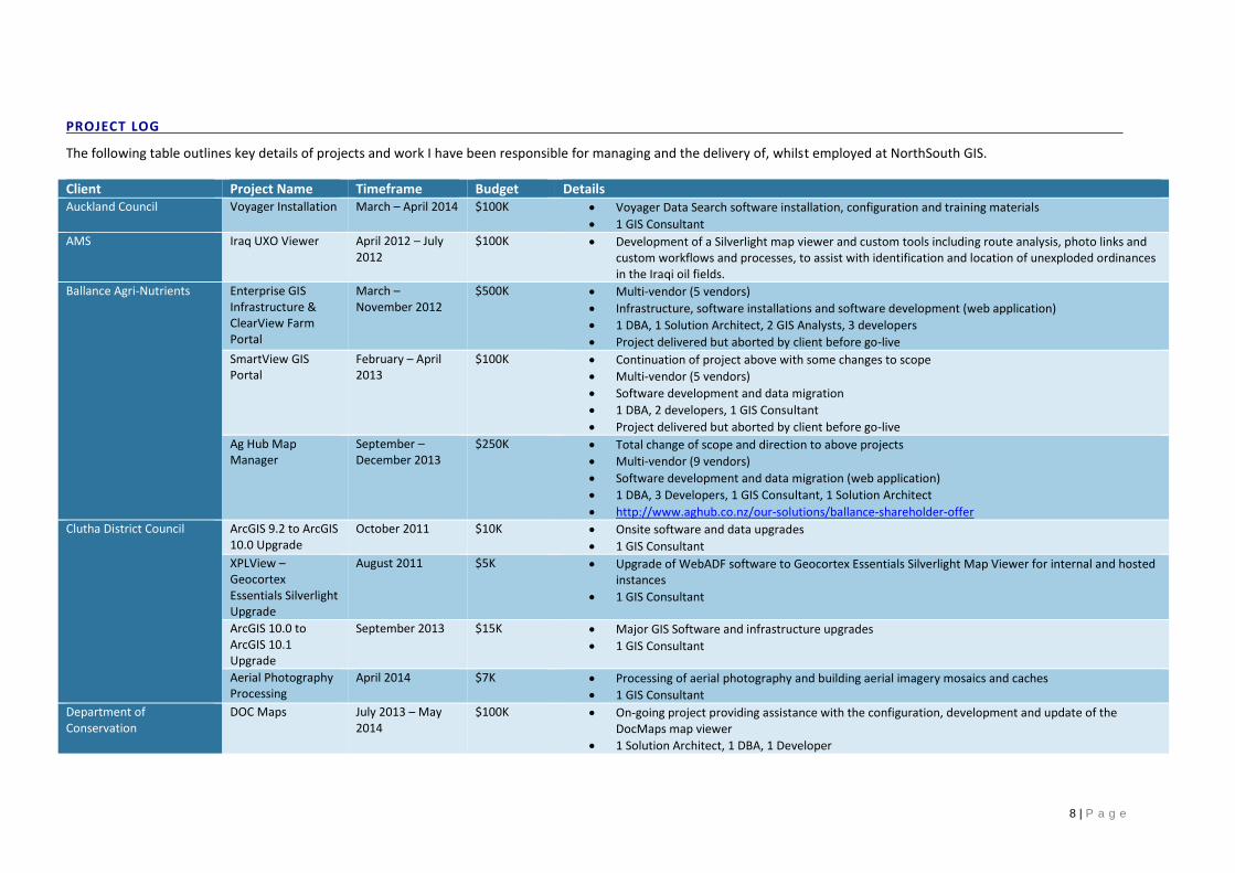
PROJECT LOG
The following table outlines key details of projects and work I have been responsible for managing and the delivery of, whilst employed at NorthSouth GIS. Client Project Name Timeframe Budget Details Auckland Council Voyager Installation March – April 2014 $100K Voyager Data Search software installation, configuration and training materials
1 GIS Consultant
AMS Iraq UXO Viewer April 2012 – July 2012
$100K Development of a Silverlight map viewer and custom tools including route analysis, photo links and custom workflows and processes, to assist with identification and location of unexploded ordinances in the Iraqi oil fields.
Ballance Agri-Nutrients Enterprise GIS Infrastructure & ClearView Farm Portal
March – November 2012
$500K Multi-vendor (5 vendors)
Infrastructure, software installations and software development (web application)
1 DBA, 1 Solution Architect, 2 GIS Analysts, 3 developers
Project delivered but aborted by client before go-live
SmartView GIS Portal
February – April 2013
$100K Continuation of project above with some changes to scope
Multi-vendor (5 vendors)
Software development and data migration
1 DBA, 2 developers, 1 GIS Consultant
Project delivered but aborted by client before go-live
Ag Hub Map Manager
September – December 2013
$250K Total change of scope and direction to above projects
Multi-vendor (9 vendors)
Software development and data migration (web application)
1 DBA, 3 Developers, 1 GIS Consultant, 1 Solution Architect
http://www.aghub.co.nz/our-solutions/ballance-shareholder-offer
Clutha District Council ArcGIS 9.2 to ArcGIS 10.0 Upgrade
October 2011 $10K Onsite software and data upgrades
1 GIS Consultant
XPLView – Geocortex Essentials Silverlight Upgrade
August 2011 $5K Upgrade of WebADF software to Geocortex Essentials Silverlight Map Viewer for internal and hosted instances
1 GIS Consultant
ArcGIS 10.0 to ArcGIS 10.1 Upgrade
September 2013 $15K Major GIS Software and infrastructure upgrades
1 GIS Consultant
Aerial Photography Processing
April 2014 $7K Processing of aerial photography and building aerial imagery mosaics and caches
1 GIS Consultant
Department of Conservation
DOC Maps July 2013 – May 2014
$100K On-going project providing assistance with the configuration, development and update of the DocMaps map viewer
1 Solution Architect, 1 DBA, 1 Developer

9 | P a g e
http://maps.doc.govt.nz/mapviewer/index.html?viewer=dto
GPX Upload Tool March – April 2014 $35K Development of bespoke tools for use with Geocortex Essentials, to easily convert GPS tracks and waypoint data into GIS features in the correct NZTM projection
1 developer
Far North District Council Far North Maps XPLView – Geocortex Essentials Upgrade
August 2011 $5K Upgrade of WebADF software to Geocortex Essentials Silverlight Map Viewer for internal and hosted instances
1 GIS Consultant
http://apps.geocirrus.co.nz/Viewer.html?Viewer=FarNorthMaps-Public
Aerial Photography Processing
February – April 2014
$10K Processing of aerial photography and building aerial imagery mosaics and caches
1 GIS Consultant
Hawkes Bay Regional Council
ArcGIS 9.2 to 10.0 Software Upgrade
October 2011 $10K Onsite software and data upgrades
1 GIS Consultant
Biosecurity and Land Management Tools
November 2011 – March 2012
$50K Upgrade and redevelopment of custom ArcGIS Desktop Biosecurity and Land Management Tools for use with ArcGIS 10.0
1 Developer
ArcGIS 10.0 to 10.1 Software Upgrade
October 2012 $10K Onsite software and data upgrades
1 GIS Consultant
ArcGIS 10.0 to 10.1 Software Upgrade
October 2013 $10K Onsite software and data upgrades
1 GIS Consultant
Geocortex Essentials Installations and Upgrades
October 2012 – March 2014
$5K -$10K per time
Ongoing regular upgrades of Geocortex Essentials software, map services and configuration on HBRC infrastructure
Horizons Regional Council SLUI Tool Upgrade October 2011 $15K Upgrade of SLUI tool to work with ArcGIS 10
1 Developer
FireStorm Map Viewer
August 2012 $35K Development of a Geocortex Essentials Silverlight Map Viewer to map wind and fire risk information, but integrating with Hilltop and the fire weather system
2 Developers, 1 GIS Consultant
Infrastructure & Software Upgrade
February 2014 8K Upgrade of GIS infrastructure and installation of ArcGIS 10.2. software
1 GIS Consultant
IRIS Installations and Configuration
February 2014 $3K Installation and configuration of IRIS (Integrated Regional Information System) Mapping Components
1 GIS Consultant
Hutt City Council ArcGIS 9.2 to 10.0 Software Upgrade
October 2011 $10K Onsite software and data upgrades
1 GIS Consultant
Geocortex Essentials Silverlight Map Viewer
November 2011 – March 2012
$54K Onsite installation and configuration of Geocortex Essentials Silverlight map viewer, map service updates, and development of custom tools, including an online DPS Payment Module, Aerial Imagery time slider tool and Automated LIM Map processing and publishing.
1 GIS Consultant, 1 DBA, 3 Developers
http://gisweb.huttcity.govt.nz/Gis_Viewer/Default.aspx
Geocortex Essentials HTML5 Map Viewer
February 2014 $8K Upgrade of existing Geocortex Essentials Silverlight map viewer to Geocortex Essentials HTML5 version, including responsive design for use of mobile devices
1 GIS Consultant, 1 DBA, 1 Developer
http://gisweb.huttcity.govt.nz/Gis_Viewer/Default.aspx

10 | P a g e
DPS Payment Module
February 2014 $12K Rework and upgrades to the Silverlight DPS Payment Module, to make use of features available in the HTML5/Javascript, including rework of the backend processes and implementation of new features from DPS.
1 Developer
Request for Payment (RFS)
April – May 2014 $52K HTML5/Javascript map embedded in a web form that integrates with Hutt City Council back-end system Confirm and corporate GIS databases.
3 developers
Invercargill City Council ArcGIS 9.2 to 10.0 Software Upgrade
October 2011 $10K Onsite software and data upgrades
1 GIS Consultant
XPLView – Geocortex Essentials Upgrade
August 2011 $5K Upgrade of WebADF software to Geocortex Essentials Silverlight Map Viewer for internal and hosted instances
1 GIS Consultant
http://apps.geocirrus.co.nz/Viewer.html?Viewer=ICC-Public
ArcGIS 10.0 to 10.1 Software Upgrade
October 2012 $10K Onsite software and data upgrades
1 GIS Consultant
ArcGIS 10.0 to 10.1 Software Upgrade
October 2013 $10K Onsite software and data upgrades
1 GIS Consultant
Annual Data Updates
September 2011 September 2012 September 2013
$5K per time Regular annual data updates (rating information and land base/parcel information)
1 GIS Consultant
KiwiRail GEVIS Updates July 2012 $20K Upgrades to Silverlight Geographic Vehicle Information System (train and rail vehicle real time tracking system) for internal system at KiwiRail
1 GIS Developer
GEVIS Mobile September 2013 $80K Development of a mobile-enabled (including offline) HTML5/Javascript web application vehicle tracking system for use in the field by KiwiRail staff and contractors
3 developers, 1 GIS Consultant
Enterprise GIS Infrastructure
March – April 2014 $30K Design, installation and configuration of a fully active-active enterprise GIS infrastructure and software, including DEV, UAT and PROD environments
1 GIS Solution Architect
Land Information New Zealand (LINZ)
Forward Works November 2013 – July 2014
$650K Distributed multi-vendor project developing a responsive web application for use in the Canterbury rebuild.
Agile delivery
1 Solution Architect, 1 DBA, 1 GIS Consultant, 3 Developers
http://www.forwardworks.co.nz
Ministry of Education School Enrolment Zone Mapping
April – June 2014 $20K Digitisation and mapping of 100 school enrolment zones
4 GIS Analysts
Northland Regional Council Northland XPLView – Geocortex Essentials Upgrade
August 2011 $10K Upgrade of WebADF software to Geocortex Essentials Silverlight Map Viewer for internal and hosted instances
1 GIS Consultant
Bus Routes Web Viewer
September 2012 $8K Development of a web viewer focused on Northland Region bus routes, including bus stops, routes and links to timetables
IRIS Installations and Configuration
August 2013 $3K Installation and configuration of IRIS (Integrated Regional Information System) Mapping Components
1 GIS Consultant
NorthSouth GIS Internal Project January – February N/A Review of a number of cloud-based agile recording and reporting tools, and subsequent

11 | P a g e
Reporting Tool 2014 implementation and configuration of Jira
geoCirrus Infrastructure and Software Upgrades
February – March 2014
$50K Upgrade of geoCirrus infrastructure and software to ArcGIS 10.2 as well as upgrade of hosted client sites, map services and databases to Geocortex Essentials 2.0 and Arc GIS 10.2
1 Solution Architect, 1 DBA, 3 GIS Consultants
Internal Infrastructure Upgrade
May – July 2014 $50K Review and upgrade of internal infrastructure including development of plans for migration to a fully cloud-based back office solution.
1 Solution Architect, 1 Systems Administrator, 1 DBA
SharePoint Migration
April – June 2014 $20K Migration of NSG’s SharePoint-based document management system from an on-premise instance to Office 365 Sharepoint.
1 System Administrator, 1 Solution Architect
PF Olsen GIS Health Check May 2013 $10K Review of current state of GIS solution and systems, and recommendations for future state options
1 Solution Architect, 1 DBA, 1 GIS Consultant
Enterprise GIS Infrastructure
May – July 2013 $20K Design, installation and configuration of an enterprise GIS infrastructure and software, including support for mobile workers
1 GIS Solution Architect, 1 DBA, 1 GIS Consultant
Geocortex Essentials Map Viewer
August 2013 $20K Installation and configuration of a Silverlight and HTML5 map viewer, custom workflows and tools.
1 GIS Consultant, 1 Developer
Imagery Storage Strategy
November 2013 $10K Review of current imagery storage solution, and recommendations and design of a future-state imagery storage solution.
1 DBA, 1 GIS Consultant
Porirua City Council Porirua Pathfinder Silverlight Application
October 2011 – March 2012
$75K Development of a Silverlight web application focused on walkways and recreation in Porirua City.
Data model design, and conversion of walkway data to fit data model
2 Developers, 2 GIS Consultants
MapInfo to Esri GIS System Migration
July 2012 – September 2012
$40K Upgrade and migration of PCC’s GIS infrastructure, software and data from MapInfo format to Esri
1 DBA, 1 Solution Architect, 2 GIS Consultants
Geocortex Essentials Map Viewers
October 2012 $20K Installation and configuration of internal and external Geocortex Essentials Silverlight map viewer, custom workflows and tools.
1 GIS Consultant, 1 Developer
Geocortex Essentials – Tech 1 CI Integration
November 2012 – February 2013
$30K Development of two-way integration between PCC’s corporate system Technology One CI with Geocortex Essentials via web services
2 GIS Developers
Geocortex Essentials HTML5 Map Viewer
October 2013 – December 2013
$35K Installation, configuration and development of custom tools and workflows for internal facing, and external facing Geocoretx Essentials HTML5 viewers
1 GIS Consultant, 1 GIS Developer
http://gis.pcc.govt.nz/HTML5/
Porirua Pathfinder HTML5
November 2013 – February 2014
$35K Replacement of the Silverlight Porirua Pathfinder web application, with a Javascript responsive, mobile enabled application, including rework of the data model and data structures
2 GIS Developers, 1 GIS Consultant
http://gis.pcc.govt.nz/pathfinder/
Port of Taranaki Geocortex Essentials Map Viewers
July 2013 – October 2013
$33K Initial configuration and development of Geocortex Essentials Silverlight and HTML5 map viewers allowing port workers and contractors access to utilities, and property and leases information.
Data conversion of utilities information from AutoCAD to Esri ArcGIS format
Database and infrastructure configuration and population

12 | P a g e
1 DBA, 1 GIS Consultant, 1 Developer
Rayonier Matariki Forests GIS Health Check April 2014 $15K Review of current state of GIS solution and systems, and recommendations for future state options
1 Solution Architect, 1 DBA, 1 GIS Consultant
Taranaki Regional Council Regional Xplorer XPLView – Geocortex Essentials Upgrade
August 2011 $10K Upgrade of WebADF software to Geocortex Essentials Silverlight Map Viewer for internal and hosted instances
1 GIS Consultant
http://apps.geocirrus.co.nz/?Viewer=TaranakiRegionalXplorer-Public
ArcGIS Land Management and Farm Map Tools
January – March 2012
$20K Upgrade and redevelopment of custom ArcGIS Desktop Land Management and Farm Map Tools for use with ArcGIS 10.0
1 Developer
ArcGIS Biosecurity Tools
March – April 2012 $10K Upgrade and redevelopment of custom ArcGIS Desktop Biosecurity Toolset for use with ArcGIS 10.0
1 Developer
Brushweed April – July 2012 $100K Design and development of an ArcGIS WPF Runtime mobile application (for use on laptops) for pest plant infestation recording and management.
Development of a desktop web based pest plant map viewer, for reporting and internal council use (Geocortex Essentials Silverlight based).
Run using agile principles, on an iterative basis.
2 Developers, 1 GIS Consultant
Aerial Photography Contract Management
November 2012 – February 2013
$40K Management of the aerial photography acquisition contract and process.
Post processing, imagery mosaic and cache building for final delivery
Vendor Management (NZAM)
1 GIS Consultant (for imagery processing)
GIS Strategic Review May 2013 $15K Strategic review of the TRC Spatial roadmap, and provision of advice and recommendations for future state
1 GIS Consultant
Regional Xplorer HTML5 Viewer
August 2013 $11K Configuration of a Geocortex Essentials HTML5 mobile-enabled version of Regional Xplorer Web Map Viewer
1 GIS Consultant
http://apps.geocirrus.co.nz/HTML5/Index.html?viewer=trc
Te Puni Kokiri Lake Taupo Right of Way Data Analysis
August 2012 – October 2012
$45K Data analysis and presentation of properties around Lake Taupo for a Treaty Claim, including documentation of findings, and a standalone map viewer (ArcGIS Publisher) for dissemination of data to a range of Government Departments
2 GIS Consultants
Timaru District Council Timaru XPLView – Geocortex Essentials Upgrade
July 2011 $10K Upgrade of WebADF software to Geocortex Essentials Silverlight Map Viewer for internal and hosted instances
1 GIS Consultant
Authority Integration
April 2012 $15K Development of two-way integration between TDC’s corporate system Authority with Geocortex Essentials via web services
2 GIS Developers
Upper Hutt City Council Regional Xplorer XPLView – Geocortex Essentials Upgrade
August 2011 $10K Upgrade of WebADF software to Geocortex Essentials Silverlight Map Viewer for internal and hosted instances
1 GIS Consultant
http://apps.geocirrus.co.nz/?Viewer=TaranakiRegionalXplorer-Public
Xplorer HTML5 January 2013 $10K Development of custom tools and configuration of a Geocortex Essentials HTML5 mobile-enabled

13 | P a g e
Viewer version of Upper Hutt City Xplorer Web Map Viewer
2 Developers, 1 GIS Consultant
http://xplorer.upperhuttcity.com/
Wellington City Council Pathfinder February 2013 $24K Development of a version of Porirua Pathfinder Silverlight web application for Wellington City, including rework of the data model.
1 GIS Consultant, 1 Developer