vale of glamorgan local development plan 2011 - 2026
TRANSCRIPT


Page 1
Vale of Glamorgan Local Development Plan 2011 - 2026
Sustainable Settlements Appraisal
1. INTRODUCTION
1.1 As part of the Local Development Plan (LDP) Draft Preferred Strategy stage, the Council has assessed which settlements are
capable of accommodating additional sustainable development. The purpose of this study was to identify which settlements
can provide for most of the everyday needs of local residents. The Council will ultimately need to allocate sufficient land in the
LDP for housing, employment and other land uses in accordance with the Wales Spatial Plan and Planning Policy Wales
(2002).
1.2 This study seeks to meet the following objectives:
Objective1: To assess the need for residents to commute beyond their settlement to employment and retail facilities.
Objective2: To measure the accessibility of settlements by public transport.
Objective3: To measure the potential for a resident’s everyday needs for services and facilities to be met within that
settlement.

Page 2
2. CONTEXT
Policy
2.1 Planning Policy Wales (2002) states that “UDPs (LDPs) need to provide a framework to stimulate, guide and manage change
towards sustainability.” “In their land allocation policies and proposals, local planning authorities should:
• Promote sustainable patterns of development, identifying previously developed land and buildings, and indicating locations for
higher density development at hubs and interchanges and close to route corridors where accessibility on foot and by bicycle
and public transport is good;
• Maintain and improve the vitality, attractiveness and viability of town, district, local and village centres;
• Foster development approaches that recognise the mutual dependence between town and country, thus improving linkages
between urban areas and their rural surroundings.” (paragraph 2.5.2 refers)
2.2 In preparing LDPs, PPW advises Local Planning Authorities to assess the extent to which their settlement strategies are
“consistent with minimising the need to travel and increasing accessibility by modes other than the private car. A broad
balance between housing and employment opportunities should be promoted to minimise the need for long distance
commuting. Local authorities should adopt policies to locate major generators of travel demand such as housing, employment,
retailing, leisure and recreation, and community facilities including libraries, schools and hospitals within existing urban areas
or in other locations which are, or can be, well served by public transport, or can be reached by walking or cycling. Preparing
accessibility profiles for public transport, walking, cycling and freight may assist local authorities in plan preparation and
assessing possible development sites. Wherever possible travel intensive developments should be located at major public
transport nodes or interchanges. Higher density development, including residential development should be encouraged, near

Page 3
public transport nodes, or near corridors well served by public transport (or with the potential to be so served).” (paragraph
2.5.3 refers)
2.3 Planning Policy Wales (2002) also stipulates that ‘In planning for housing in rural areas it is important to recognise that
development in the countryside should embody sustainability principles, benefiting the rural economy and local communities
while maintaining and enhancing the environment. There should be a choice of housing, recognising the housing needs of all,
including those in need of affordable or special needs provision. In order to safeguard the character and appearance of the
countryside, to reduce the need to travel by car and to economise on the provision of services, new houses in the countryside
away from existing settlements recognised in UDPs, or from other areas allocated for development, must be strictly controlled.
Many parts of the countryside have isolated groups of dwellings. Sensitive filling in of small gaps, or minor extensions to such
groups, may be acceptable, but much depends upon the character of the surroundings, the pattern of development in the area
and the accessibility to main towns and villages.’ (paragraph 9.2.18 refers)
Settlements within the Vale of Glamorgan
2.4 The Vale of Glamorgan is Wales' most southern Unitary Authority and covers 33097 hectares (331 square miles) with 53
kilometres of coastline, of which 19 kilometres is Heritage Coast. The rich mix of undulating farmland, valley basins;
woodland and unspoilt coastline is a testimony to the richness and diversity of the natural environment of the Vale of
Glamorgan. The population of the Vale was recorded as 119,292 in the 2001 Census, having grown steadily for many years.
2.5 The main settlements are Barry, Penarth, Dinas Powys, Llantwit Major and Cowbridge, the latter two being historic market
towns that are surrounded by smaller rural settlements. Barry, the largest town with a population of 48,000, is the Vale's
administrative centre, a seaside resort and port. Cardiff International Airport is located at Rhoose, 3 miles west of Barry.

Page 4
3. PROCESS
Study Settlements
3.1 The settlements for this study were derived from a previous study undertaken in 2005 which sought to establish whether
Council supported bus services were being selected in the most equitable and effective way. The analysis showed the
Council’s current bus service levels compared with the recommended levels in the Local Area Bus Strategy. This study builds
on that original piece of work by including various criteria to determine the suitability of a particular settlement in relation to
accommodating new development. The criteria deemed necessary for this assessment, were identified at various LDP
stakeholder workshops and are detailed as follows:
• The presence of employment / retail opportunities;
• The presence and quality of existing public transport services;
• The range of services and facilities available.
3.2 A total of 96 settlements were identified within the Vale of Glamorgan for assessment in the sustainable settlement study.
(Appendix 1)
3.3 The population figures quoted have been taken from an average household count based on the assumption that each
household comprises of 2.4 people. Any households lying outside the settlements were not considered; therefore there may
be some discrepancy with the household average and the 2001 Census figures. Plan A in Appendix 2 shows the parameters
of each settlement examined in the study.

Page 5
3.4 It should be noted that the figures in the 2001 Census were not used as they were not broken down in the same way as this
study. In undertaking the assessment, it was evident that many of the settlements identified shared access to facilities in
nearby settlements and were therefore effectively part of larger settlements. These smaller, sub areas of main settlements,
were therefore rationalised with the larger settlements as shown below:
Common name used for
further analysis purposes Individual settlements considered suitable for integration
St Athan Eglwys Brewis / Picketston / RAF East Camp / RAF West Camp / St Athan
Cowbridge Cowbridge / Llanblethian
Sully Cog / Sully
Rhoose Fontygary / Rhoose
Llantwit Major Boverton / Llantwit Major
Barry Barry / The Bendricks
Bonvilston Bonvilston / Greenway
Sustainability Criteria
3.5 To identify which settlements might be appropriate for the purpose of accommodating new development, each one was
assessed against a number of sustainability criteria. For this study, the individual criteria were based on key services that
contribute towards meeting the daily needs of the population and reduce reliance to travel to access facilities and services. Each
of the settlements were assessed against the criteria and then ranked depending on their performance. They were then added
together to calculate a settlement's position for each criterion. This provided their 'Overall Assessment'.

Page 6
The following table 1 shows the selection criteria used for this study:
Table 1
Criteria Indicators Weighting
Social considerations Population Zero weighted but used to identify ranges
of settlements.
Retail Services / Employment General Store / Post Office /
Employment Area e.g. power station,
garden centres, R.A.F. base
Considered of highest importance to
reduce the number of journeys, as these
are basic every day essential needs and
therefore triple scored. *
Transport Services and Accessibility
Bus / Rail
Seen as very important to reduce the
number of trips made by single car
occupancy, therefore public transport was
double rated. **
Community Services and Facilities
Preferable and Desirable Services
and Facilities e.g. schools,
restaurants, play areas etc
Each of the other community services and
facilities were given a single score
each.***

Page 7
*Retail / Employment Services – Core Services
Objective: To assess the need for residents to commute beyond their settlement to employment and retail facilities.
3.6 The availability of employment opportunities locally can contribute towards delivering sustainable communities. It can assist
significantly in sustaining, enhancing and revitalising rural settlements. It also provides the opportunity to have an important
daily activity and generator of trips provided locally, thereby reducing the need to travel by the private car. Local employment
opportunities are a positive indicator of suitable sustainable settlements. Whilst there is no certainty that these local
employment opportunities are taken up by local residents, it is nevertheless important that these opportunities exist.
3.7 Likewise the same principle applies where there is a general store or a post office. Providing these locally can enhance
community spirit and reduce the number of trips made by car. Again there is no guarantee that the residents will utilise these
local facilities, but still the opportunities exist. These three services taken together have been identified as ‘Core Services’.
Each settlement that contained these services was given a score of 1 for each individual service and those that did not have
any were given a zero score. Therefore the maximum scoring for these criteria was 3 and the minimum was zero. The Core
Services were then weighted and the scores tripled to weight them three times higher than the other service areas, given the
relevance and importance of these services.
**Transport Services and Accessibility
Objective: To measure the accessibility of settlements by public transport.
3.8 It is important that a settlement suitable for development has good accessibility to services and facilities, both to those within
the towns/villages and those close by, thereby helping communities to meet many of their everyday needs. Good access to
services and facilities, including public transport, gives choice to the user and can reduce the reliance on private cars for

Page 8
travel. It also allows more social inclusion for the young and others who cannot drive or afford a car. Whilst walking and
cycling are both highly sustainable modes of travel, they were not included in this study.
3.9 The public transport provision of each settlement was considered and any area that has in excess of an hourly service was
given a scoring of 1, those that are serviced between hourly and two hourly a scoring of 0.66, those that are serviced less than
that a scoring of 0.33. Those that are not serviced did not score (0). This process was undertaken for week day services,
evening services, Saturday day services, Saturday evening services, Sunday day services and Sunday evening services. The
scores were then totalled and doubled to give a double weighting to the transport element.
***Community Services and Facilities
Objective: To measure the potential for a settlement's everyday needs for services and facilities to be met within that
settlement.
3.10 A sustainable settlement needs to offer the community a reasonable range of services and facilities. This objective will help to
concentrate any limited new development to areas that are well-serviced.
3.11 There appears to be no definitive grouping that concisely defines those services and facilities needed to provide for these
everyday needs. Accordingly, for the purposes of this exercise, the Council has grouped the services and facilities necessary
to enable a settlement to function as a sustainable settlement, to include those considered with most benefit for the
community, as well as leisure services and facilities that are 'desirable' in meeting the everyday needs of residents.

Page 9
3.12 This broad division will help to distinguish between those settlements which offer a range of services and facilities more suited
to meeting the day to day needs of the local community and those having limited services and facilities. The relevant services
and facilities considered were as follows:-
• Surgery
• Post Box
• Public House
• Place of Worship
• Community Hall
• Restaurant / Takeaway
• Primary School
• Secondary School
• Nursery
• Doctor
• Dentist
• Outside Play Area
• Formal Sports Pitch
• Leisure Centre
3.13 The data used in the assessment of settlements comes from an audit of services and facilities undertaken during spring 2007.
This was based on a desk top study using the Council’s Geographical Information System, aerial photographs, the internet as
well as site visits to each location to confirm the existence of such facilities.
3.14 A score of 1 has been attributed to the presence of a service/facility in a settlement and a score of 0 for its absence. The
settlements have been ordered by the total sum of the services and facilities.
Page 10
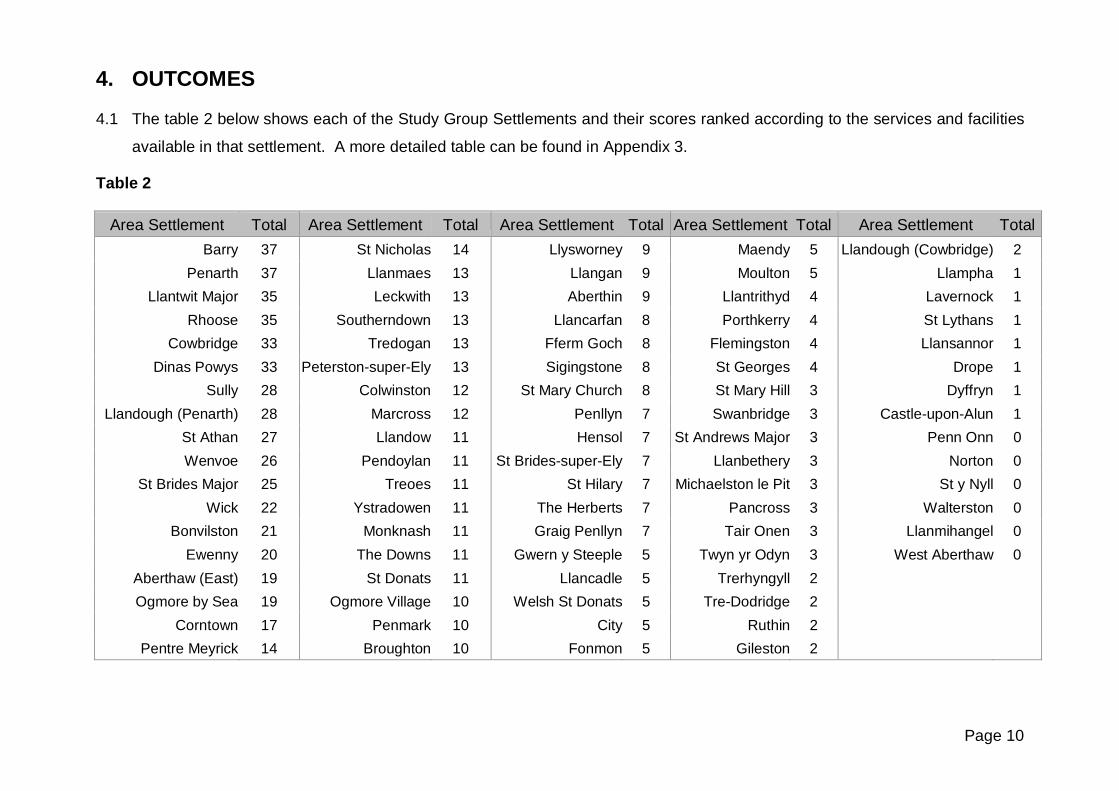
4. OUTCOMES
4.1 The table 2 below shows each of the Study Group Settlements and their scores ranked according to the services and facilities
available in that settlement. A more detailed table can be found in Appendix 3.
Table 2
Area Settlement Total Area Settlement Total Area Settlement Total Area Settlement Total Area Settlement Total Barry 37 St Nicholas 14 Llysworney 9 Maendy 5 Llandough (Cowbridge) 2
Penarth 37 Llanmaes 13 Llangan 9 Moulton 5 Llampha 1 Llantwit Major 35 Leckwith 13 Aberthin 9 Llantrithyd 4 Lavernock 1
Rhoose 35 Southerndown 13 Llancarfan 8 Porthkerry 4 St Lythans 1 Cowbridge 33 Tredogan 13 Fferm Goch 8 Flemingston 4 Llansannor 1
Dinas Powys 33 Peterston-super-Ely 13 Sigingstone 8 St Georges 4 Drope 1 Sully 28 Colwinston 12 St Mary Church 8 St Mary Hill 3 Dyffryn 1
Llandough (Penarth) 28 Marcross 12 Penllyn 7 Swanbridge 3 Castle-upon-Alun 1 St Athan 27 Llandow 11 Hensol 7 St Andrews Major 3 Penn Onn 0 Wenvoe 26 Pendoylan 11 St Brides-super-Ely 7 Llanbethery 3 Norton 0
St Brides Major 25 Treoes 11 St Hilary 7 Michaelston le Pit 3 St y Nyll 0 Wick 22 Ystradowen 11 The Herberts 7 Pancross 3 Walterston 0
Bonvilston 21 Monknash 11 Graig Penllyn 7 Tair Onen 3 Llanmihangel 0 Ewenny 20 The Downs 11 Gwern y Steeple 5 Twyn yr Odyn 3 West Aberthaw 0
Aberthaw (East) 19 St Donats 11 Llancadle 5 Trerhyngyll 2 Ogmore by Sea 19 Ogmore Village 10 Welsh St Donats 5 Tre-Dodridge 2
Corntown 17 Penmark 10 City 5 Ruthin 2 Pentre Meyrick 14 Broughton 10 Fonmon 5 Gileston 2

Page 11
5. CONCLUSIONS
5.1 The findings of the study clearly show that there is a hierarchy of settlements within the Vale. These range from urban town
centres and historic market towns that are fully integrated as a result of the benefit from a wide range of services and facilities,
and reasonable public transport access, to rural settlements with some facilities and limited public transport access, to small
hamlets and isolated properties with minimal, or no community services and facilities or public transport access.
5.2 It is evident that all town centres and areas with a population of more than 1000, (listed below), benefit from a range of
services and facilities more suited to meeting the day to day needs of the local community and can therefore sustain additional
growth in the LDP.
• Barry • Llantwit Major • Cowbridge • Sully • St Athan
• Penarth • Rhoose • Dinas Powys • Llandough (Penarth) • Wenvoe
5.3 In accordance with Planning Policy Wales (2002), in order to provide a choice of housing, whilst still safeguarding the
character and appearance of the countryside, a small number of settlements, that have a reasonable number of community
facilities and transport services, have been identified as capable of accommodating some additional growth . However, any
new development would only be of benefit through the imposition of planning obligations to promote improvements in existing
facilities, the provision of new community facilities and improvements to accessibility with a particular emphasis on public
transport. They are generally the larger populated rural areas (as listed below) that have sufficient population to sustain the
additional services and facilities required for them to grow.

Page 12
5.4 There is another category of isolated groups of dwellings in the countryside where sensitive infilling of small gaps, or minor
extensions to such groups, may be acceptable. Many of them include a primary school and a public house among the
dwellings or other comparable services that make them more appealing in terms of sustainability, although further
consideration of these areas would need to include a strategic environmental assessment.
• Aberthaw (East) • Colwinston • Aberthin • St Nicholas • Pendoylan
• Treoes • Llysworney • Llancarfan • Llanmaes
• Peterston super Ely • Sigingstone • Penllyn • Llandow
5.5 The following are settlements whose key attraction is their rurality. Whilst some may have scored highly due to their proximity
to the strategic road network or the fact that they have a daily bus service (albeit infrequent) they have very little in the way of
community facilities or services. Therefore they are not considered to be suitable for additional development.
• St Brides Major • Wick • Ewenny • Ogmore by Sea
• Southerndown • Ystradowen • Bonvilston • Corntown

Page 13
• Ogmore Village • Pentre Meyrick • The Downs • Graig Penllyn • Leckwith
• Penmark • Monknash • St Donats • Gwern y Steeple • Tredogan
• Broughton • Llangan • Marcross • Llancadle • Maendy
• The Herberts • Fferm Goch • St Mary Church • Welsh St Donats • Moulton
• Hensol • St Brides-super-Ely • St Hilary • City • Fonmon
5.6 In order to conclude what is deemed suitable for future development in the way of sustainability, it is envisaged that many rural
settlements cannot realistically fulfil this role principally because they do not have the range of services and facilities
necessary to meet this requirement. Many of them are small hamlets or isolated houses/farm houses or barn conversions
with no access to public transport services, basic community services or employment opportunities. Some scored a single
point on the basis that they had a post box, a place of worship, a pub or restaurant etc, but no more than that. These hamlets
are still very important as they contribute to the character of the rural Vale and require protection from over-development
through planning controls that safeguard their environment. It is reasonable to conclude that due to the high reliance on the
private car to access basic amenities; these areas are unsustainable and are unsuitable for further development. The areas
identified are as follows:
• Llantrithyd • St Andrews Major • Trerhyngyll • Lavernock • Penn Onn • Swanbridge
• Porthkerry • Llanbethery • Tre-Dodridge • St Lythans • Norton • Twyn yr Odyn
• Flemingston • Michaelston le Pit • Ruthin • Llansannor • St Y Nyll • Llampha
• St Georges • Pancross • Gileston • Drope • Walterston • Castle-upon-
Alun
• St Mary Hill • Tair Onen • Llandough (Cow) • Dyffryn • Llanmihangel • West Aberthaw

Page 14
Appendix 1 – Settlements identified within the Vale of Glamorgan for assessment in the sustainable settlements study.
The population figures quoted have been taken from an average household count based on the assumption that each household
comprises of 2.4 people.
Table 3 - Study Group Settlements and Population Aberthaw (East) - 101 Drope - 73 Leckwith - 26
Aberthaw (West) - 103 Dyffryn - 34 Llanbethery - 67
Aberthin - 139 Eglwys Brewis - 653 Llanblethian - 509
Barry - 47653 Ewenny - 269 Llancadle - 50
Bendricks - 167 Fferm Goch - 108 Llancarfan - 163
Bonvilston - 293 Flemingston - 86 Llandough (Cowbridge) - 62
Boverton - 1219 Fonmon - 55 Llandough (Penarth) - 1990
Broughton - 118 Fontygary - 1481 Llandow - 185
Castle-upon-Alun - 29 Gileston - 67 Llangan - 48
City - 29 Graig Penllyn - 300 Llanmaes - 312
Cog - 299 Greenway - 46 Llanmihangel - 12
Colwinston - 187 Gwern Y Steeple - 72 Llansannor - 38
Corntown - 194 Hensol - 48 Llantrithyd - 74
Cowbridge - 3500 Llampha - 7 Llantwit Major - 7744
Dinas Powys - 7262 Lavernock - 48 Llysworney - 170

Page 15
Study Group Settlements and Population Maendy - 36 Porthkerry - 55 St Nicholas - 185
Marcross - 101 RAF East Camp - 600 St y Nyll - 17
Michaelston-le-Pit - 79 RAF West Camp - 600 Sully - 2879
Monknash - 10 Rhoose - 2122 Swanbridge - 41
Moulton - 24 Ruthin - 22 Tair Onen - 67
Norton - 7 Sigingstone - 91 The Downs - 115
Ogmore-by-Sea - 910 Southerndown - 161 The Herberts - 84
Ogmore Village - 40 St Andrews Major - 34 Tre-Dodridge - 31
Pancross - 41 St Athan - 1296 Tredogan - 2
Penarth - 20396 St Brides Major - 610 Trerhyngyll - 86
Pendoylan - 50 St Brides-Super-Ely - 70 Treoes - 355
Penllyn - 127 St Donats - 43 Twyn-yr-Odyn - 67
Penmark - 125 St Georges - 55 Walterston - 36
Penn Onn - 26 St Hilary - 110 Welsh St Donats - 192
Pentre Meyrick - 34 St Lythans - 43 Wenvoe - 1080
Peterston-super-Ely - 276 St Mary Church - 58 Wick - 434
Picketston - 24 St Mary Hill - 46 Ystradowen - 420
Total: 96 Settlements

Page 16
Appendix 2

Page 17
Appendix 3 - Study Group Settlements ranked according to the services and facilities available in that settlement.
Table 4
Area Settlement Community & Employment
Transport Services & Accessibility
Community Facilities Overall Total Weighted
Barry 3 7 14 24 37
Penarth 3 7 14 24 37
Rhoose 3 7 14 24 37
Llantwit Major 3 6 14 23 35
St Athan 3 6 14 23 35
Sully 3 6 14 23 35
Dinas Powys 2 7 14 23 34
Cowbridge 3 5 14 22 33
Bonvilston 3 5 13 21 32
Llandough (Penarth) 2 6 12 20 30
Wenvoe 2 6 10 18 28
St Brides Major 2 5 11 18 27
Wick 2 4 10 16 24
Ewenny 2 5 6 13 22
Ogmore by Sea 2 4 7 13 21
Aberthaw (East) 1 6 5 12 20

Page 18
Area Settlement Community & Employment
Transport Services & Accessibility
Community Facilities Overall Total Weighted
Corntown 2 2 9 13 19
Pentre Meyrick 1 5 2 8 15
Llanmaes 1 2 7 10 14
Monknash 0 4 6 10 14
St Nicholas 0 5 4 9 14
Leckwith 0 5 3 8 13
Peterston super Ely 0 2 9 11 13
Southerndown 0 4 5 9 13
Tredogan 0 6 1 7 13
Colwinston 0 2 8 10 12
Llandow 1 2 5 8 12
Marcross 0 4 4 8 12
Treoes 1 1 7 9 12
Ystradowen 1 1 7 9 12
Pendoylan 0 2 7 9 11
Penmark 1 1 6 8 11
St Donats 0 4 3 7 11
The Downs 0 5 1 6 11
Broughton 0 4 2 6 10

Page 19
Area Settlement Community & Employment
Transport Services & Accessibility
Community Facilities Overall Total Weighted
Llangan 1 1 5 7 10
Ogmore Village 0 4 2 6 10
Aberthin 0 2 5 7 9
Fferm Goch 1 1 4 6 9
Llysworney 0 2 5 7 9
Sigingstone 0 2 4 6 8
St Mary Church 0 2 4 6 8
Graig Penllyn 0 1 5 6 7
Hensol 0 3 1 4 7
Llancarfan 0 1 5 6 7
Penllyn 0 1 5 6 7
St Brides-super-Ely 0 2 3 5 7
St Hilary 0 1 5 6 7
The Herberts 0 2 3 5 7
City 0 1 3 4 5
Gwern y Steeple 0 2 1 3 5
Llancadle 0 1 3 4 5
Maendy 0 2 1 3 5
Moulton 0 1 3 4 5

Page 20
Area Settlement Community & Employment
Transport Services & Accessibility
Community Facilities Overall Total Weighted
St Andrews Major 0 1 3 4 5
Welsh St Donats 0 1 3 4 5
Fonmon 0 1 3 4 5
Flemingston 0 1 2 3 4
Llantrithyd 0 1 2 3 4
Porthkerry 0 0 4 4 4
St Georges 0 0 4 4 4
Llanbethery 0 1 1 2 3
Michaelston le Pit 0 0 3 3 3
Pancross 0 1 1 2 3
St Mary Hill 0 1 1 2 3
Tair Onen 0 1 1 2 3
Twyn yr Odyn 0 0 3 3 3
Swanbridge 0 0 3 3 3
Gileston 0 0 2 2 2
Ruthin 0 1 0 1 2
Tre-Dodridge 0 1 0 1 2
Trerhyngyll 0 0 2 2 2
Llandough (Cowbridge) 0 0 2 2 2

Page 21
Area Settlement Community & Employment
Transport Services & Accessibility
Community Facilities Overall Total Weighted
Castle Upon Alun 0 0 1 1 1
Drope 0 0 1 1 1
Dyffryn 0 0 1 1 1
Llampha 0 0 1 1 1
Llansannor 0 0 1 1 1
St Lythans 0 0 1 1 1
Lavernock 0 0 1 1 1
Aberthaw (West) 0 0 0 0 0
Llanmihangel 0 0 0 0 0
Norton 0 0 0 0 0
Penn Onn 0 0 0 0 0
St y Nyll 0 0 0 0 0
Walterston 0 0 0 0 0


