using gis for priority assessment of road construction in kermanshah province
TRANSCRIPT
8/13/2019 Using GIS for Priority Assessment of Road Construction in Kermanshah Province
http://slidepdf.com/reader/full/using-gis-for-priority-assessment-of-road-construction-in-kermanshah-province 1/7
Using GIS for Priority Assessment of Road Construction in Kermanshah Province
S.H. Sanaei-Nejad (PhD) Ferdowsi University of Mashhad, Iran
B.Badkoo MSc Students Khajeh Nasiroddine Toosi [email protected]
S. Monajjem (PhD) Khajeh Nasiroddine Toosi University
Abstract Construction and improvement of road network is one of the most essential tasks to reduce transportcost and increase management efficiency in a country. However, considering of three factors thattraditionally are used for such studies including travel time, travel distance and population may notend to realistic results. Therefore we need to consider a multiple criteria model to take all of theeffective factors into account using Geographic Information Systems (GIS).
Kermanshah province in West of Iran was considered for this study. A dynamic database wasestablished to store and retrieve the data for the effective factors in road construction, such ashuman, social, road, driving, and vehicle factors and also the related secondary factors to each of themain ones. The data were processed and linked to the thematic maps.
A Multiple Hierarchy Decision Making (MADM) model called Analytical Hierarchy Process (AHP) wasused in a GIS platform to combine and compare the factors for the assessment. Finally, the layerswere overlaid and combined together to produce a composition map that can help decision makers forconstructing new roads and improving current road network in the province.
A pilot study was also planned to assess the results, which shows a fair agreement with the othermethods that are used by professional staffs in the related section.
There were still some differences in the results, which can be modified by changing the factor valuesbased on a new investigation.
Introduction Road transport is the most common way in transportation industry in the world and especially in Iran,where roads are used for nearly 85% of total transportation. There are different reasons that make theroad transport very important in Iran such as:- International demands for good transit between the adjacent countries.- Governmental development plan, which is based on agriculture, mineral and industrial activities.- Tourist and pilgrim demands (the latter is very important in Kermanshah province which is animportant terminal for the huge number of pilgrims who travel to Karbala from different parts of Iran).
Kashefipoor (2001) used Markof method for randomly network analyzing to present a model for roadmaintenance in Iran. Niaraki (2003) used GIS to evaluate road network in Iran. He considered roadtraffic, tourist, security and climate factors for his model. The main factors has 5, 12, 6, 3 and 4 subfactors respectively. He used a hierarchical analysis for comparing his main and sub factors. Peded etal. (1993) used GIS for road security analysis. He considered road factors, human factors and vehiclefactors for his analysis. Prasad et al. (2003) also used GIS for their case study for rural road planningprogram. Chavarria (2002) used Analytical Hierarchy Process (AHP) for a road management systemin Champaign. More researches also show that this method can be used for different conditions indifferent places.
This study is directed to investigate into road construction priority in Kermanshah province in west ofIran. There is a very complicated situation in this province for developing roads network. The provinceis very big and mountainous with different social, economic, road traffic (imbalance between demandsand current roads network), security and environmental matters. These special conditions of theprovince increase the cost of road construction projects.

8/13/2019 Using GIS for Priority Assessment of Road Construction in Kermanshah Province
http://slidepdf.com/reader/full/using-gis-for-priority-assessment-of-road-construction-in-kermanshah-province 2/7
The following subjects are considered in the general aspect of this study.
- Determining of main factors and sub factors for road construction in the area- Choosing a suitable model for comparing the attributes and combing them based on their valuesusing GIS
- Comparing the results with the old manual calculated methods- Producing a spatial data base of road maps and the related descriptive data- Assessing of priority factor for road construction in Kermanshah province
Methods and materials It is obvious that there are many factors affecting decision-making process for a road constructionproject. Therefore a Multiple Criteria Decision Making (MCDM) model should be used for such aproblem. These models are divided into two main categories, Multiple Objective-Decision –Making(MODM) and Multiple Attribute-Decision-Making (MADM). MODM models are used for planning whileMADM models are used for choosing the best option from many different available alternatives.
Figure 1. Analytical Hierarchy Process (AHP)
We used Analytical Hierarchy Process (AHP), which is a MADM model for this study. This techniquewas proposed by Tomas-L Saaty (1979). This model considers personal assessment andexperiences as well as a logical comparing of factors, which are essential for our final decisions. Wecan use a systematic vision and detail factors together in our analysis. The general systematic visionsare considered in top levels and detail factors are compared and assessed in lower levels and finallyvalues are assigned for different factors from top to the bottom levels. Figure 1 shows a chartdemonstrating general aspect of the model.
Based on the above chart the model uses the following function to combine the criteria:
F=k 1X1 + k 2X2 + k 3X3
In which K1, K2 and K3 are the coefficients for X1, X2 and X3 criteria respectively and should bedetermined by professional personnel who are involved in road construction planning in the area.
After the tree structure is completed for the related criteria, all of the criteria in each level arecompared together two by two. The results of this comparing process are assessed as figures that areweighting factors for the criteria. These figures are classified between 1-9 according to the table 1.Values 2, 4, 6 and 8 are also used for the interval values according the decision maker.
Relative comparing of criterion i with criterion j The Value
Equally Preferred 1Less Preferred 3

8/13/2019 Using GIS for Priority Assessment of Road Construction in Kermanshah Province
http://slidepdf.com/reader/full/using-gis-for-priority-assessment-of-road-construction-in-kermanshah-province 3/7
Moderately Preferred 5
Very Strong Preferred 7
Extremely Preferred 9
Table 1. Criteria values
In this study we used the following parameters to provide the hierarchical tree structures of the criteriain road construction in Kermanshah province:
8/13/2019 Using GIS for Priority Assessment of Road Construction in Kermanshah Province
http://slidepdf.com/reader/full/using-gis-for-priority-assessment-of-road-construction-in-kermanshah-province 4/7
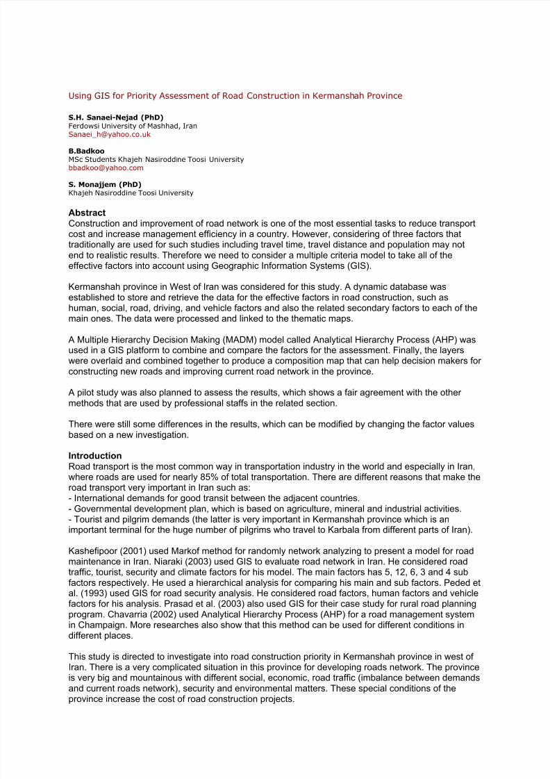
ResultsThe criteria were evaluated by consulting of professional staffs in road administration office of Kermanshah province and they were compared two by two. Table 2 shows a typical comparison results.
The selected criteria converted into thematic maps and the related data was saved in a database.Some technical works has been done to organize and adjust the maps to make them ready for a GIS
analysis based on the model.
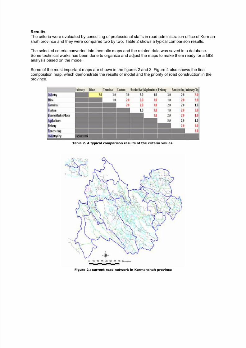
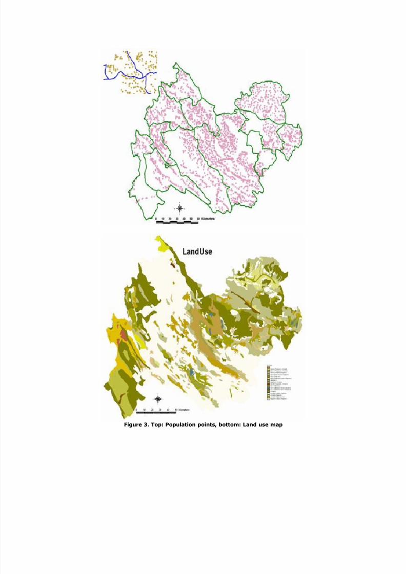
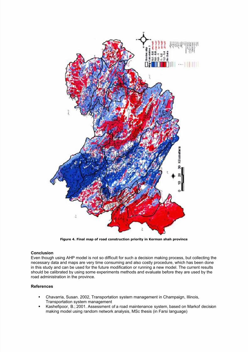
Some of the most important maps are shown in the figures 2 and 3. Figure 4 also shows the finalcomposition map, which demonstrate the results of model and the priority of road construction in theprovince.
Table 2. A typical comparison results of the criteria values.
Figure 2.: current road network in Kermanshah province
8/13/2019 Using GIS for Priority Assessment of Road Construction in Kermanshah Province
http://slidepdf.com/reader/full/using-gis-for-priority-assessment-of-road-construction-in-kermanshah-province 5/7
Figure 3. Top: Population points, bottom: Land use map
8/13/2019 Using GIS for Priority Assessment of Road Construction in Kermanshah Province
http://slidepdf.com/reader/full/using-gis-for-priority-assessment-of-road-construction-in-kermanshah-province 6/7
Figure 4. Final map of road construction priority in Kerman shah province
Conclusion Even though using AHP model is not so difficult for such a decision making process, but collecting thenecessary data and maps are very time consuming and also costly procedure, which has been donein this study and can be used for the future modification or running a new model. The current resultsshould be calibrated by using some experiments methods and evaluate before they are used by theroad administration in the province.
References
Chavarria, Susan. 2002, Transportation system management in Champaign, Illinois,Transportation system management
Kashefipoor, B.; 2001. Assessment of a road maintenance system, based on Markof decisionmaking model using random network analysis, MSc thesis (in Farsi language)

8/13/2019 Using GIS for Priority Assessment of Road Construction in Kermanshah Province
http://slidepdf.com/reader/full/using-gis-for-priority-assessment-of-road-construction-in-kermanshah-province 7/7
Lupien, E., Moorland, H. and Dagermond, W., 1987. Network analysis in geographicinformation systems, photogrametric engineering and remote sensing, Vol. 53.
Pede A., B. hay- yehia, A.S. Hakkert,1993, Irc-Info-based Geographical information systemfor road safty analyses and improvement.
Prasada, Rao., B.Kangadurai, P.K.Jain and Dr Neelam Jain. 2003. Information System forRural Road Network Planning a Case Study, Map India Conference.