use of geophysical logs in hydrogeological studies and borehole designs ... · times, their...
TRANSCRIPT

Vol.:(0123456789)1 3
Applied Water Science (2018) 8:191 https://doi.org/10.1007/s13201-018-0804-9
ORIGINAL ARTICLE
Use of geophysical logs in hydrogeological studies and borehole designs: case study of Apapa coastal area, Lagos, Nigeria
R. A. Jimoh1 · O. M. Bankole2 · K. Ahmed3 · O. A. Christopher4 · M. A. Adeniji5 · J. Ebhodaghe6 · S. O. Sedara7 · P. W. Obende8 · O. Alebu9 · E. A. Ezima10
Received: 27 October 2017 / Accepted: 11 September 2018 / Published online: 6 October 2018 © The Author(s) 2018
AbstractThe hydrogeological study of Apapa, a coastal part of Lagos, Nigeria, has been investigated using combined geophysical borehole logs, consisting of natural gamma and electrical resistivity components and ditch cutting samples. This study utilized data from 10 boreholes to delineate freshwater aquifer and proposes the best borehole design and construction for optimum groundwater developments in the study area. The electrical resistivity log data show that the depth to the freshwater interface varies across the study area occurring between 150 and 160 m and as shallow as 110 m in a borehole. The variations in depth of the freshwater interfaces are attributed to the extent of saline/brackish water contamination and distribution of rock types. Based on these differences and the inability to identify water quality from ditch cuttings, borehole geophysical logging is a vital tool in providing in situ subsurface information of the rock types and fluid contents in groundwater studies. This fur-ther demonstrates that geophysical borehole logs play an important part in borehole design for development of water wells.
Keywords Geophysical borehole logs · Electrical resistivity · Natural Gamma · Groundwater · Coastal aquifer · Freshwater–saltwater intrusion
Introduction
The continuous increase in world population growth, indus-trialization, and agricultural complexes has led to high demand for portable water globally, thus making access to safe drinking water a difficult reality. Generally, groundwa-ter is the most important source of freshwater resource for domestic and industrial in coastal regions. However, avail-ability of freshwater is severe in most developing nations, and a lot of people lack access to potable water.
The study area, Apapa, is a densely populated and highly industrialized area with several interconnected paved roads and partly sand-filled reclaimed islands (e.g., Snake Island). As a consequence, Apapa is usually flooded, and most of the constructed water drainages are mostly blocked with human and industrial hazardous wastes during the raining season. Like most other coastal parts of Lagos, groundwater from shallow aquifers in coastal Apapa have been greatly contam-inated by variety of pollutants including sewage disposals, municipal and industrial wastes, and spills and leaks from
* R. A. Jimoh [email protected]
1 Geomodeling and Geoexplore Consultants Limited, P.O.BOX 302, Ikorodu, Lagos State, Nigeria
2 Department of Marine Science and Technology, Federal University of Technology, P.M.B. 704, Akure, Ondo State, Nigeria
3 Groundwater and Geophysical Services Limited, Oshodi-Isolo, Lagos State, Nigeria
4 Copine, National Space Research and Development Agency (NASRDA), Federal Ministry of Science and Technology, P.M.B 022, Ile-Ife, Osun State, Nigeria
5 Department of Physics, Federal University of Agriculture Abeokuta, Abeokuta, Nigeria
6 Department of Physics, Delta State University, P.O. BOX 1, Abraka, Delta State, Nigeria
7 Department of Physics and Electronics, Adekunle Ajasin University, Ondo State, Nigeria
8 Sizex Nigeria Limited, Lagos State, Nigeria9 Department of Science Laboratory Technology, School
of Applied Science and Technology, Auchi Polytechnic, Auchi, Edo State, Nigeria
10 Nigerian Petroleum Development Company, Subsidiary of NNPC, Warri, Delta State, Nigeria

Applied Water Science (2018) 8:191
1 3
191 Page 2 of 11
transport and storage of liquids. This makes availability of freshwater at shallow depths practically impossible due to the problem of saltwater intrusion and infiltration of polluted surface waters into the water table. Groundwater extraction for domestic and industrial use in the Apapa Area and envi-rons is only possible in well-constructed boreholes drilled into deeper aquifers, which are very expensive for an aver-age citizen to afford. Therefore, the only source of available water for people living in these areas is water from poorly constructed and less expensive hand-dug wells or boreholes. However, water from these wells is not only contaminated but dangerous to human health because of the presence of high concentrations of total dissolved solids and certain inor-ganic constituents, making the water unfit and unpleasant for drinking and other domestic uses. Unfortunately, in an attempt to save borehole drilling costs and non-compliance to government regulations, most of the boreholes drilled to deeper depths are poorly designed, constructed, and left uncontrolled for groundwater quality degradation. Often-times, their performances are short lived due to saltwater intrusion or infiltration of polluted water.
Delineation of freshwater aquifer in coastal regions is of particular importance because of the influence of sea level change on groundwater salinity and/or migration of salt/brackish water intrusion into groundwater aquifers. Episodic changes in freshwater–saltwater interface levels in coastal groundwater are due to climatic variations, sea level fluc-tuations, decrease in recharge, and increase in groundwater pumping (Meisler et al. 1985; Barlow 2003). These factors impose hydrologic conditions that usually influence migra-tion of saltwater from the sea toward boreholes in hydraulic connection with the sea, thereby reducing the natural gradi-ent to the sea and make the freshwater–saltwater interface move inland (Buckley 2000; Buckley et al. 2001). Saltwater and freshwater–saltwater interface can be detected directly in drilled wells by electrical electrodes (downhole geophysi-cal logging) and water sampling, or indirectly by electri-cal geophysical methods such as ground penetrating radar, surface geophysical resistivity (vertical electrical sounding) (Melloul and Goldenberg 1997). Both direct and indirect electrical geophysical techniques have been successfully used in evaluating coastal aquifer characteristics and moni-toring of saltwater intrusions in groundwater studies because of the influence of salinity on electrical conductivity (sharp contrast in conductivity between freshwater and saltwater) (Archie 1942; Hallenburg 1987; Repsold 1989; Mares et al. 1994; Buckley 2000; Buckley et al. 2001).
In this study, electrical and gamma geophysical log data were integrated with drill cutting samples from ten freshly drilled boreholes to delineate the freshwater–saltwater tran-sition zone (interface), identify potential freshwater aqui-fers, and propose the best completion designs for borehole constructions in the coastal Apapa Area of Lagos, Nigeria.
A multi-parameter geophysical probe was used to simultane-ously measure the gamma and electrical resistivity. These combined techniques can provide more valuable and near-accurate information of the subsurface strata and help in identification, evaluation, well completion designs, construc-tion, and development of potential freshwater for sustainable use in coastal aquifers. Geophysical logs have proven to be valuable tools in well design because they can indicate the exact depths and thicknesses of the right aquifers (permeable zones) where quality groundwater is available and substan-tial to be screened for groundwater extraction. They can also show impermeable layers and intervals with poor-quality water to be cement grouted and sealed during construction of water wells. This paper also reiterates the importance of geophysical borehole logging in groundwater studies of not only coastal aquifers, but generally in management of groundwater in sedimentary strata.
Geophysical borehole logging
Downhole geophysical borehole logging is an in situ nonde-structive process of measuring the physical, chemical, and structural properties of penetrated geological formations and surrounding borehole annulus. The technique involves lowering of sonde (probe) into a borehole using suspended armored cable or wire device called wireline or logging cable. The logging cable is connected to the winch and transmits recorded signals to the digital computers for data visualization, monitoring, and recording. The measured sub-surface properties are dependent on the type of the lowered probe. Geophysical logs have been widely used, especially in petroleum industry, as tools in unraveling information on aquifer and fluid characteristics, paleo-hydrogeology, and correlation and distribution of subsurface sedimentary strata. Because geophysical logging is a repeatable and comparable process, it can be used to provide continuous in situ information on the subsurface rock type, bed thick-ness, permeability, porosity, bulk density, resistivity, and the nature of saturating fluids (Hallenburg 1987; Repsold 1989; Mares et al. 1994; Keys 1997; Buckley 2000; Hearst et al. 2000; Buckley et al. 2001). In addition, geophysical logs can confirm the completion details, identify the individual water inflows, characterize salinity and freshness, determine freshwater–saline water interface, and identify problems in cased boreholes (Buckley et al. 2001). It can therefore act as a guide in borehole designs and rehabilitating process of damaged boreholes.
Interpretations of the geophysical logs are based on the empirical field data, variation of log signatures in response to geologic and hydrogeological character of subsurface strata and fluid contents, and the knowledge of the local geology of the study area (Keys 1997; Buckley 2000; Hearst et al. 2000;
Applied Water Science (2018) 8:191
1 3
Page 3 of 11 191
Buckley et al. 2001). Despite its numerous applications in subsurface characterization, geophysical logs are not a sub-stitute for drilling and drill cuttings, which are not sufficient to evaluate the water quality and hydraulic properties of the aquifer in hydrogeological studies and borehole design but rather supply in situ complimentary information on aquifer rock types and fluid contents. Therefore, understanding the hydrogeology and aquifer characteristics of subsurface strata (especially in coastal aquifers that are commonly affected by saline intrusion) typically requires accurate information of the aquifer water quality and hydraulic properties (Buckley 2000; Buckley et al. 2001). This information is commonly obtained from combination of drill cuttings or cores, geo-physical borehole logging, and aquifer testing.
In groundwater hydrogeological studies, the commonly used geophysical logs include natural gamma (NGAM), spontaneous potential (SP), electrical resistivity (ER), caliper, and temperature. The gamma and SP logs provide information on the rock type; ER log measures the resist-ance of the rock and salinity of water contents, while the caliper and temperature logs record the borehole diameter and the water temperature, respectively (Mares et al. 1994; Spies 1996). Only the NGAM and long-normal (LN) ER data are presented in this study. The NGAM records the natural radiation emitted from the rocks around a borehole. The NGAM log is affected by the distribution of potassium, uranium, and thorium and their isotopes present in an earth material, making it a useful tool in determining the lithology
of a borehole (Keys 1997; Hearst et al. 2000; Buckley et al. 2001). Typically in sedimentary sequences, fine-grained materials, including shales, clays, silts, record high NGAM counts because of the affinity of clay minerals for potassium, and coarse-grained materials such as sandstones and lime-stones have relatively low NGAM counts. ER is a measure of the apparent electrical resistance or conductance within the formations, and it is affected by the lithology, water quality, and pore geometry (Mares et al. 1994; Keys 1997; Hearst et al. 2000; Buckley et al. 2001). The resistivity of fresh-water-bearing sands is higher than freshwater-bearing clay because of the high conductivity of clay. However, saltwater-bearing sands will have a lower resistivity.
The study area
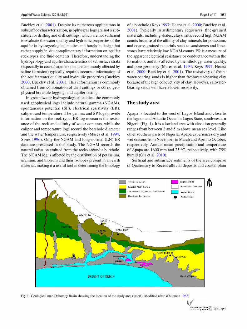
Apapa is located to the west of Lagos Island and close to the lagoon and Atlantic Ocean in Lagos State, southwestern Nigeria (Fig. 1). It is a lowland area with elevation generally ranges from between 2 and 5 m above mean sea level. Like other southern parts of Nigeria, Apapa experiences dry and wet seasons from November to March and April to October, respectively. Annual mean precipitation and temperature of Apapa are 1600 mm and 25 °C, respectively, with 75% humid (Ola et al. 2010).
Surficial and subsurface sediments of the area comprise of Quaternary to Recent alluvial deposits and coastal plain
Fig. 1 Geological map Dahomey Basin showing the location of the study area (insert). Modified after Whiteman 1982)

Applied Water Science (2018) 8:191
1 3
191 Page 4 of 11
sands of the Dahomey Basin (Fig. 1; Jones and Hockey 1964; Durotoye 1975; Longe et al. 1987). The Dahomey Basin is an extensive Cretaceous, Tertiary and Recent sedi-mentary basin covering three southwestern states (Lagos, Ogun and Ondo) in the Nigeria sector of the basin (Jones and Hockey 1964; Whiteman 1982; Olabode and Moham-med 2016). The basal Cretaceous deposits of the Dahomey Basin, known as the Abeokuta Group, consist essentially of coarse-grained sandstones with interlayered shale in the lower part. Locally, the Abeokuta Group has been sub-divided into Ise, Afowo, and Araromi formations (Omat-sola and Adegoke 1981). The overlying Tertiary deposit is composed of the Ewekoro, Akinbo shales, Oshoshun, Ilaro, and Alluvial coastal plain sand formations (Fig. 1). The uppermost alluvial and coastal plain sands deposit of Qua-ternary to Recent age consist of alternating successions of unconsolidated sands and clays, occurring along the coastal belt and as alluvial deposits along major rivers.
Numerous hydrogeological studies have been carried out in Apapa and environs to understand the hydrogeology and aquifer characteristics, and delineate the fluctuating fresh-water–saltwater interface (e.g., Oteri 1986; Longe et al. 1987; Adepelumi et al. 2009; Ola et al. 2010; Ayolabi et al. 2013). Most of these studies identified four major aquifers and increasing salinity with depth within the alluvial and coastal plain sand. The aquifers are separated by alternating sequences of clay, clayey sand, and sandy clay with varying thicknesses. The uppermost aquifer sands contain freshwater that is highly susceptible to infiltration of polluted surface water and anthropogenic and biologic pollution. This is the aquifer that many locals get there water for domestic use and/or drinking from shallow hand-dug wells. The under-lying aquifer contains mixture of freshwater and saltwater (brackish water), corresponding to the freshwater–saltwater
transition zone. This aquifer unit is underlain by saltwater-bearing sands with variable thickness across the coastal part of Lagos. The fourth aquifer unit contains freshwater and is present at deeper depths. The depth to the freshwater–salt-water interface between the third and fourth aquifer varies, but constrained to be in the range of 150–200 m (Ola et al. 2010).
Methodology
Geophysical borehole logs and ditch cutting samples col-lected from ten drill holes were available for this study (Fig. 2; Table 1). The logs were run in uncased boreholes immediately after drilling to varying depths. The logging process was carried out using a 600DL Delta Epsilon log-ging unit that is equipped with a combined GE-9409 sonde that simultaneously measures the NGAM, SP, and ER (short normal, SN: 16″ and LN: 64″) data. The NGAM and SP log components are qualitatively interpreted to provide infor-mation on the different rock units encountered in the bore-holes, and the resistivity components provide information on the rock units and quality of the water contents in the non-invaded zone (64″). Combined, ditch cutting sample obser-vations and the NGAM log were used to construct geologic litho-sections of individual borehole in the studied area to model various rock units within the study area.
Interpretation of the NGAM log is based on the assump-tion that the deflection, after establishing a shale/clay baseline, of the log signal to the left (negative) indicate a permeable groundwater-bearing zone (aquifer-usually sand and sandstones) and a deflection to the right (positive) indi-cate an impermeable groundwater units (shale or clay). On the ER log, in the absence of shale/clay, high and low ER
Fig. 2 Location map of the study area showing the posi-tions of the boreholes
BH 1
BH 2
BH 3
BH 4BH 5
BH 6BH 7
BH 8BH 9
BH 10
538000 539000 540000 541000 542000 543000 544000 545000
711000
712000
713000
714000
715000

Applied Water Science (2018) 8:191
1 3
Page 5 of 11 191
values indicate presence of freshwater and saltwater/brack-ish water, respectively. Furthermore, the NGAM deflections and ER data were correlated to delineate the freshwater-bearing aquifers. For instance, a deflection of the NGAM to the left with increase in resistivity values corresponds to a freshwater-bearing aquifer with lower total dissolved solids (TDS), whereas a low resistivity value corresponds to saline/brackish water aquifer with high TDS (Table 2).
Results and interpretation
Digitized representative geophysical log and ditch cutting data of the studied boreholes are presented in Figs. 3, 4, and 5. For brevity, only three of the studied boreholes (BH 1, BH 4, and BH 8), which are considered to representative of different parts of the study area, (Fig. 2) are described in details. Generally, the NGAM log and ditch cutting sam-ples revealed that the subsurface lithology of the study area in all the boreholes consists of alternating layers of sand, clay, clayey sand, and sandy clay (Figs. 3, 4, and 5). The thickness of the various units varies across the area, and the major water-bearing sand-(aquifer) units mostly consist of thin lenses of interlayered impermeable clays (aquiclude or aquitard). In our interpretations, thick sand units that are
separated by thin clay/clayey sand/sandy clay layers are merged and considered as a single uniform and continuous sand unit (Figs. 4 and 5). In addition, in few of the bore-holes, where thick continuous sand layer is rare, clayey sands and/or sandy clay constitute the major water-bearing units (Fig. 3).
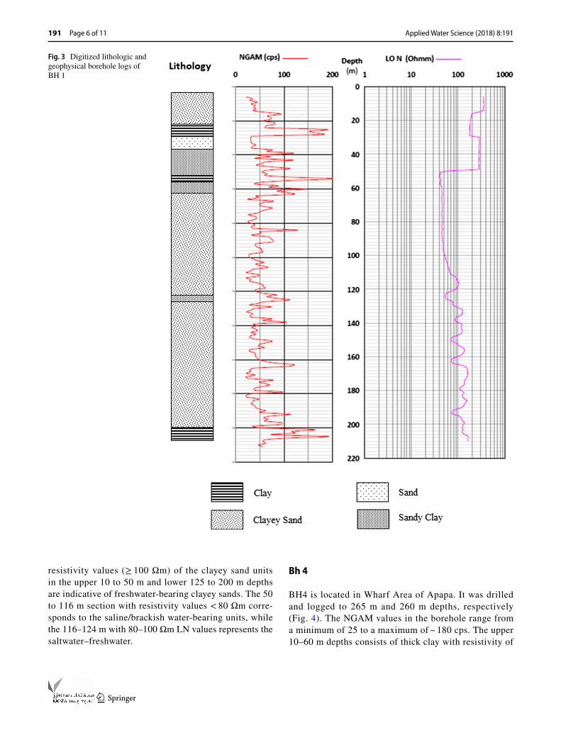
Bh 1
BH1 is located in Tin Can Island and was drilled and logged to 234 m and 211 m depths, respectively (Fig. 3). The NGAM log shows values ranging from 25 to ~ 200 cps that corresponds to different layers. The lithol-ogy of the upper part of BH1 changes from clayey sand at 10 m through interlayered clay and sands from 20 to 35 m to a sandy clay dominated unit from 35 to ~ 60 m depth. The LN resistivity values of these rock units range between 200 and 350 Ωm in the upper clayey sands and decreases 40 Ωm in the sandy clay units at ~ 60 m depth. The middle to lower rock of the borehole are essentially dominated by a very thick clayey sand from 60 to 200 m with a thin interlayered sandy clay between 122 and 124 m. The LN resistivity values of the zone above the thin sandy clay range from 45 to 100 Ωm, whereas those below have values between 100 and 180 Ωm. The high
Table 1 Summary of studied boreholes in Apapa
Borehole refer-ence
Location Coordinates Drilled depth (m)
Depth logged (m)
Bh1 Tin Can Island N0626′07.72″, E00320′09.88″ 234 211Bh2 Wharf 1, Apapa N0626′22.44″, E00322′57.64″ 234 184Bh3 Apapa N0627′.32.8″, E00322′.16.7″ 216 214Bh4 Wharf 2, Apapa N0626′20.80″, 00322′47.50″ 265 265Bh5 Wharf 3, Apapa N0626′24.60, E00322′56.20 260 260Bh6 Snake Island N0625′26.00″, E00320′15.80″ 260 250Bh7 Snake Island N0625′31.60″, E00320′25.40″ 240 222Bh8 Azare Crescent N0626.109′, E00324.964′ 220 220Bh9 Apapa N0626′15.4″, E00322′46.2″ 236 171Bh10 Apapa N0626′31.53″,E00322′47.98″ 195 191
Table 2 Resistivity values for water and sediment rock Resistivity (ῼ-m) Rock type Interpretation
0.5–2.0 Very porous sand, or saturated clay Seawater, very saline water TDS = 20,000 mg/l2.0–4.5 Porous sand, or saturated clay Saline water, TDS = 10.000 mg/l4.5–10.0 Sandy saturated or sandy clay Salty Brackish water, TDS = 10,000–1500 mg/l10.0–15.0 Sandy clay, sandy gravel Brackish water, TDS = 5000–1500 mg/l15.0–30.0 Sand, gravel, some clay Poor-quality freshwater, TDS = 1500–700 mg/l30.0–70.0 Sand, gravel, minor clay Intermediate-quality freshwater, TDS ~ 100 mg/l70.0–100.0 Sand, gravel, no clay Good-quality freshwater, TDS small> 100.0 Coarse sand, gravel, no clay Very good-quality freshwater, TDS very small
Applied Water Science (2018) 8:191
1 3
191 Page 6 of 11
resistivity values (≥ 100 Ωm) of the clayey sand units in the upper 10 to 50 m and lower 125 to 200 m depths are indicative of freshwater-bearing clayey sands. The 50 to 116 m section with resistivity values < 80 Ωm corre-sponds to the saline/brackish water-bearing units, while the 116–124 m with 80–100 Ωm LN values represents the saltwater–freshwater.
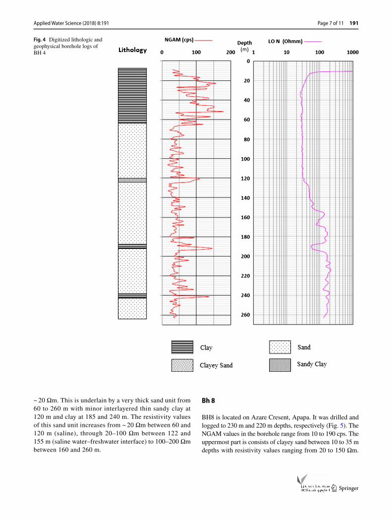
Bh 4
BH4 is located in Wharf Area of Apapa. It was drilled and logged to 265 m and 260 m depths, respectively (Fig. 4). The NGAM values in the borehole range from a minimum of 25 to a maximum of ~ 180 cps. The upper 10–60 m depths consists of thick clay with resistivity of
Fig. 3 Digitized lithologic and geophysical borehole logs of BH 1
Applied Water Science (2018) 8:191
1 3
Page 7 of 11 191
~ 20 Ωm. This is underlain by a very thick sand unit from 60 to 260 m with minor interlayered thin sandy clay at 120 m and clay at 185 and 240 m. The resistivity values of this sand unit increases from ~ 20 Ωm between 60 and 120 m (saline), through 20–100 Ωm between 122 and 155 m (saline water–freshwater interface) to 100–200 Ωm between 160 and 260 m.
Bh 8
BH8 is located on Azare Cresent, Apapa. It was drilled and logged to 230 m and 220 m depths, respectively (Fig. 5). The NGAM values in the borehole range from 10 to 190 cps. The uppermost part is consists of clayey sand between 10 to 35 m depths with resistivity values ranging from 20 to 150 Ωm.
Fig. 4 Digitized lithologic and geophysical borehole logs of BH 4

Applied Water Science (2018) 8:191
1 3
191 Page 8 of 11
This section is underlain by clay unit from 35 to 48 m with resistivity values between 40 and 70 Ωm. The underlying unit consists of thin sand and clayey sand from 48 to 138 m with considerable increase in resistivity values from 40 to 100 Ωm, corresponding to the saline/brackish water–freshwater inter-face. This is underlain by a thick clean sand unit from 138 to 220 m with resistivity values ranging from 100 to 300 Ωm, consistent with freshwater-bearing sand.
Discussion
Lithology identification and understanding the charac-teristics of saturating fluids in the subsurface rocks in groundwater developments are important because they give insights into the characters of potential aquifers for freshwater extraction. The varying lithology of the study
Fig. 5 Digitized lithologic and geophysical borehole logs of BH 8

Applied Water Science (2018) 8:191
1 3
Page 9 of 11 191
boreholes that include alternating sequence of clay, clayey sand, sandy clay, and sand is typical of Coastal Plain Sands described in the Dahomey Basin (e.g., Oteri 1986; Longe et al. 1987; Adepelumi et al. 2009; Ola et al. 2010; Ayolabi et al. 2013). The coastal plain sands have been described to be the major source of fresh groundwater water in Lagos and environs (Coode Blizard et al. 1996).
The integrated geophysical log data and ditch cutting data in the study identified three principal sections show-ing two major transitions in the studied boreholes. The first section corresponds to the high resistivity freshwater-bearing sands in the shallow part, mostly < 50 m depth, resting on the saltwater-bearing sands in most of the bore-holes. This transition from freshwater to saltwater tends to be sharp (Fig. 3). The occurrence of this freshwater shallow unit tends to be location and lithology depend-ent as it is absent in some of the boreholes (e.g., BH4). However, groundwater extraction from this shallow aqui-fer for drinking and domestic use is unpleasant and need to be discouraged because of the potential risk of pollu-tion and saltwater infiltration (e.g., Omosuyi et al. 1999; Ola et al. 2010). The second section, mostly between the 60 and 150 m intervals, represents the saltwater and salt-water/brackish water–freshwater interface based on their low resistivity values (Table 2; Figs. 3, 4, and 5). The contact between saltwater/brackish water and freshwater of this transition zone appears to be gradual. The saltwa-ter–freshwater interface is underlain by freshwater-bearing units at deeper depths and this is evidenced by increase in the resistivity values in the boreholes. The depths to this saltwater–freshwater interface vary across the study area, commonly between 150 and 160 m, and as shallow as 110 m in BH3 (Fig. 6). The depth to the top of the freshwater aquifer is shallowest in BH3 and deepens south-ward toward the coast (Figs. 2). These sand units below the transition zone typically constitute the freshwater-bearing aquifers for groundwater abstraction, judging by their high resistivity values (usually > 100 Ωm) (Figs. 3, 4, and 5). Ola et al. (2010) delineated the saltwater–freshwater inter-face between 126 and 130 m in the Lagos Island, which is northeast of the study area. The difference in the depth to interface is due to the complex lithology (multilayer) variations of the Lagos Island and its coastal environs, increase and long duration of groundwater pumping from the deeper aquifers, and variation of saltwater intrusion with hydraulic gradient.
In coastal regions, groundwater commonly flow from inland recharge areas at hydraulic heads are typically high (high elevation) to areas where the hydraulic gradient are low (low elevation) in coastal regions (Buckley 2000; Barlow 2003). In such occurrence, because of its lower density, freshwater tends to remain above the saltwater, and this probably explains the presence of freshwater
unconfined aquifer at shallower depths in some parts of the studied boreholes (Figs. 3 and 4). However, repeated changes in sea level have been documented to influence and change the direction of groundwater flow of in coastal aquifers (Meisler, et al. 1985; Buckley 2000; Buckley et al. 2001). The reversed transition in the deeper con-fined aquifers of the studied boreholes, where saltwater overlies freshwater probably results from the influence of variation in sea level caused by storms and tides, and reversed the groundwater flow direction at the ocean floor and moves seawater into the freshwater aquifers (Meisler et al. 1985; Buckley 2000; Buckley et al. 2001; Barlow 2003). This is evidenced by the presence of broad salt-water–freshwater interface that can be attributed to the cyclic movement of seawater due to fluctuations of sea level and subsequent change in the freshwater–seawater interface (Meisler et al. 1985; Buckley et al. 2001). In such scenario, increase in sea level will result in inland movement of saltwater from the coast and mixes with the freshwater aquifers, thereby creating a mix transition zone. Also, during decrease in sea level, freshwater will advanced seaward and mixes with the seawater. Repeated change in sea level will thus produce a broad mixing zone in which the saltwater predominates in the deeper seawards and freshwater predominates in the shallower landwards. In addition, excessive water withdrawals from the deeper aquifers of the Coastal Plain Sands can also be responsible for the inland movement of saltwater from the coast and variation of the depth to saltwater–freshwater interface in the Apapa area and environs.
Fig. 6 Depth to the top of the saltwater–freshwater interface map in the study area

Applied Water Science (2018) 8:191
1 3
191 Page 10 of 11
Implication for borehole designs
Borehole design is the process of defining the drilling depth, physical materials, and dimensions for construction of a borehole (Harter 2003; Kovalevsky et al. 2004). A good design aims to create a structurally stable, long-lasting, eco-nomical, and efficient borehole that allows free movement of sufficient, good quality, and sand-free groundwater from the aquifer into the well for extraction with proper protec-tion from contamination (Kovalevsky et al. 2004). Some of the main factors that determine the design of a borehole include the objective of the borehole, quantity of groundwa-ter, economic, and hydrogeological conditions (Harter 2003; Kovalevsky et al. 2004). The essential components in a bore-hole design consist of sump, screen, well-casing pipe, gravel pack, and surface and borehole seals (Fig. 7; Harter 2003; Kovalevsky et al. 2004). The sump is commonly attached to the bottom of the screen to serve as a storage space for settled sand brought into the borehole and provides a bear-ing support for the screen assembly. The screens function as the conduits through which water flow into the borehole, stabilize the borehole wall, and control entry of sand parti-cles into the borehole. The success of a borehole is mainly dependent on the performance of the screen. The length of the screen is based on the aquifer thickness, available draw-down, and nature of the water-bearing aquifer. The purpose of the blind borehole casing is to stabilize the borehole, provide a pathway for groundwater from the aquifer to the surface, prevent particles and contaminants from entering the borehole, and provide proper housing for the pump.
Based on the geophysical borehole data, the rock types, accurate thickness of each rock units, aquifer thickness, depths to different rock types, and properties of the aqui-fer, water contents can be precisely determined (Figs. 3, 4, 5). This demonstrates that geophysical borehole logs can
provide information on the essential factors needed for a well design. Two major freshwater aquifers have been distin-guished in the Coastal Apapa Area: shallow aquifers, which are prone to surface contamination and overlies saltwater-bearing sediments, and deep confined aquifer, which are encountered at depths below 150–160 m (depending on the area) and directly underlies saltwater-bearing sediments. The second deep freshwater aquifer occurs at different depths with interbedded clay intervals. For a good borehole design and water development in the study area, the delineated freshwater-bearing sand section below the saltwater–fresh-water interface should be considered for groundwater extrac-tion. The depth to this transition zone varies across the area but typically greater than 160 m depth. The length of the screen depends on the aquifer thickness of individual bore-hole and can be separated if there are no continuous sand units in the freshwater-bearing zone to maximize the quan-tity of water flow into the borehole. It is suggested that a buffer zone of 20–40 m is in place between the screens and the saltwater–freshwater interface where there is no signifi-cant thick impermeable clay layer to seal off the productive freshwater aquifer from contamination. The annulus section just above the gravel packed and the screen should be cement grouted to the top to prevent contamination of the freshwater aquifer from the saltwater–saline water interface.
Conclusions
Integrated geophysical borehole logs and ditch cutting sam-ples showed that the subsurface strata of the coastal Apapa Area is composed of alternating sequence sand, sandy clay, clayey sand, and clay. Two major freshwater aquifers have been identified: shallow aquifers, which are prone to sur-face contamination and overlies saltwater-bearing sediments, and deep confined aquifer, which are encountered at depths below 150–160 m (depending on the area) and directly underlies saltwater-bearing sediments. The second deep freshwater aquifer occurs at different depths with interbed-ded clay intervals. The delineated freshwater-bearing sand sections below the saltwater–freshwater interface have been suggested for groundwater extraction. The length of the area to be screened depends on the desired quantity of groundwa-ter, but should be at a minimum buffer distance of 30–40 m to the saltwater–freshwater interface. The section slightly above the screen should be cement grouted to the top to seal the productive aquifer from contamination of the saltwater and surface infiltration. The geophysical borehole data in this study have been able to provide detailed information on the rock types, accurate thickness of each rock units, aquifer thickness, depth to different rock types, and properties of the aquifer water contents, which are essential factors for a good borehole design. This study further stress the importance
Fig. 7 Schematic diagram showing the essential components of a borehole. Adapted from Harter 2003

Applied Water Science (2018) 8:191
1 3
Page 11 of 11 191
of geophysical borehole logging in accessing accurate and detailed aquifer information for groundwater extraction, and borehole designs, developments, and completions.
Open Access This article is distributed under the terms of the Crea-tive Commons Attribution 4.0 International License (http://creat iveco mmons .org/licen ses/by/4.0/), which permits unrestricted use, distribu-tion, and reproduction in any medium, provided you give appropriate credit to the original author(s) and the source, provide a link to the Creative Commons license, and indicate if changes were made.
References
Adepelumi AA, Ako BD, Ajayi TR, Afolabi O, Omotoso EJ (2009) Delineation of saltwater intrusion into the freshwater aquifer in Lekki Pennisula, Lagos Nigeria. Environ Geol 56:927–933
Archie GE (1942) The electrical resistivity log as an aid in determining some reservoir characteristics. Trans AIME 146:54–62
Ayolabi EA, Folorunso AF, Odukoya AM, Adenira AE (2013) Map-ping saline water intrusion into the coastal aquifer with geophysi-cal and geochemical techniques: the University of Lagos campus case (Nigeria). SpringerPlus 2(433):1–14
Barlow PM (2003) Ground water in fresh water–salt water environ-ments of the Atlantic Coast, U.S. Geological survey circular 1262
Buckley DK (2000) Some case histories of geophysical downhole logging to examine borehole site and regional groundwater movement in Celtic regions. In: Robins NS, Misteer BDR (eds) Groundwater in the celtic regions: studies in hard rock and qua-ternary hydrogeology, vol 182. Geological Society, London, pp 219–237 (Special Publications)
Buckley DK, Hinsby K, Manzano M (2001) Application of geophysical borehole logging techniques to examine coastal aquifer palaeo-hydrogeology. In: Edmunds WM, Milne CJ (eds) Palaeowaters in coastal Europe: evolution of groundwater since the Late Pleisto-cene, vol 189. Geological Society, London, pp 251–270 (Special Publication)
Coode Blizard, Oteri AU, Rofe KL (1996) Hydrogeological investiga-tion of Lagos State, final report, Vol I, II
Durotoye AB (1975) Quaternary sediments in Nigeria. In: Kogbe CA (ed) Geology of Nigeria, Lagos. Elisabeth Press, Lagos, pp 431–451
Hallenburg JK (1987) Geophysical logging for mineral and engineering applications. Penn Well Books, Tulsa
Harter T (2003) Water well design and construction. University of California Division of Agriculture and Natural Resources, 8086, FWQP Reference sheet 11.3
Hearst JR, Nelson PH, Paillet FL (2000) Well logging for physical properties, 2nd edn. Wiley, Chicester
Jones HA, Hockey RD (1964) The geology of part of Southwestern Nigeria, vol 31. Enugu, Geology Survey Nigeria, Bulletin, p 101
Keys WS (1997) A practical guide to borehole geophysics in environ-mental investigations. Lewis Publishers, Boca Raton
Kovalevsky VS, Krusemen GP, Rushton KR (2004) Groundwater stud-ies, an international guide for hydrogeological investigations, UNESCO series on groundwater No 3. UNESCO, Paris
Longe EO, Malomo S, Olorunniwo MA (1987) Hydrogeology of Lagos metropolis. J Afr Earth Sci 6(2):163–174
Mares S, Zboril A, Kelly WE (1994) Logging for the determination of aquifer hydraulic properties. Log Anal 35(6):28–36
Meisler H, Leahy PP, Knobel LL (1985) Effect of eustatic sea-level changes on saltwater-freshwater relations in the northern Atlantic Coastal Plain, U.S. Geological survey water-supply paper 2255
Melloul AJ, Goldenberg LC (1997) Monitoring of seawater mixing in coastal aquifers basic and local concerns. J Environ Manag 51(1):73–86
Ola PS, Bankole OM, Anifowose AYB (2010) Sub-surface geology and groundwater distribution patterns in Lagos Island environs, South western Nigeria. Environtropica 57:89–103
Olabode SO, Mohammed MZ (2016) Depositional facies and sequence stratigraphic study in parts of Benin (Dahomey) Basin SW Nige-ria: implications on the re-interpretation of tertiary sedimentary successions. Int J Geosci 7:210–228
Omatsola ME, Adegoke OS (1981) Tectonic evolution and cretaceous stratigraphy of the dahomey basin. J Min Geol 18:130–137
Omosuyi GO, Ojo JS, Olorunfemi MO (1999) Borehole lithologic cor-relation and aquifer delineation in parts of the coastal basin of southwestern Nigeria-implication for groundwater developments. J Appl Sci 2:617–626
Oteri AU (1986) Interpretation of electric logs in aquifers of the Dahomey basin of Nigeria. J Afr Earth Sci 2:54–61
Repsold H (1989) Well logging in groundwater developments, IAH contribution to hydrogeology, vol 9. Heise, Hannover, p 136
Spies BR (1996) Electrical and electromagnetic borehole measure-ments: a review. Surv Geophys 17:517–556
Whiteman AJ (1982) Nigeria: its petroleum geology, resources and potential, vol 1, 2. Graham and Trotman, London, p 559
Publisher’s Note Springer Nature remains neutral with regard to jurisdictional claims in published maps and institutional affiliations.