use of drone for field observation - presentation of applications in emergency response
TRANSCRIPT

Use of drone for field observationPresentation of applications in emergency response
Arnaud Vandecasteele | MapaliVincent Herbreteau | IRD & SEAS-OI
Kraichat Tantrakarnapa | Mahidol University
Mapali | Cartographics’ innovation designer

2/43
Introduction
Drones myths and realities
How does a mapping drone work?
Drones and emergency response
Conclusion
1
2
3

3/43
Introduction
Arnaud Vandecasteele
Aerial DronesAnd Remotely
Operated Vehicles

4/43
Arnaud Vandecasteele | MapaliSpecialized in geographic data acquisition and analysis
www.mapali.re0693 06 25 81
mapali_gis
Introduction
Gathering data Analysis Development Support

5/43
UMR ESPACE-DEV
Linking Earth observation, information systems and environmental integrated approaches
towards environmental observatories dedicated to sustainable development
Research group on “Environment, Societies and health Risks” (ESoR) focuses on: Infectious human diseases in the Tropics
Health issues with spatial and environmental components
Introduction

6/43
Introduction
• A precise map of your study area?• Up to date data?• Very accurate pictures of an area?• Same area mapped on different time period?• …
Have you ever wanted to have
7/43
Part I
Drones : Myths and Realities
8/43
Drone, myths and reality How does a mapping drone work? Drones and emergency response
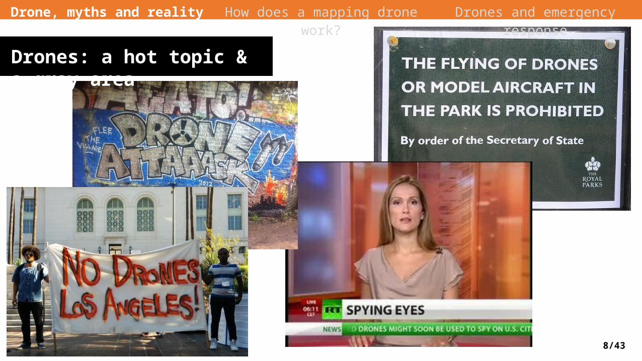
Drones: a hot topic & a gray area

9/43
Drone, myths and reality How does a mapping drone work? Drones and emergency response
Are you ready for the weirdest drone ?

10/43
Seriously?
Drone, myths and reality How does a mapping drone work? Drones and emergency response

11/43
Drone, myths and reality How does a mapping drone work? Drones and emergency response
Ok, go back to somethingmore serious!
12/43
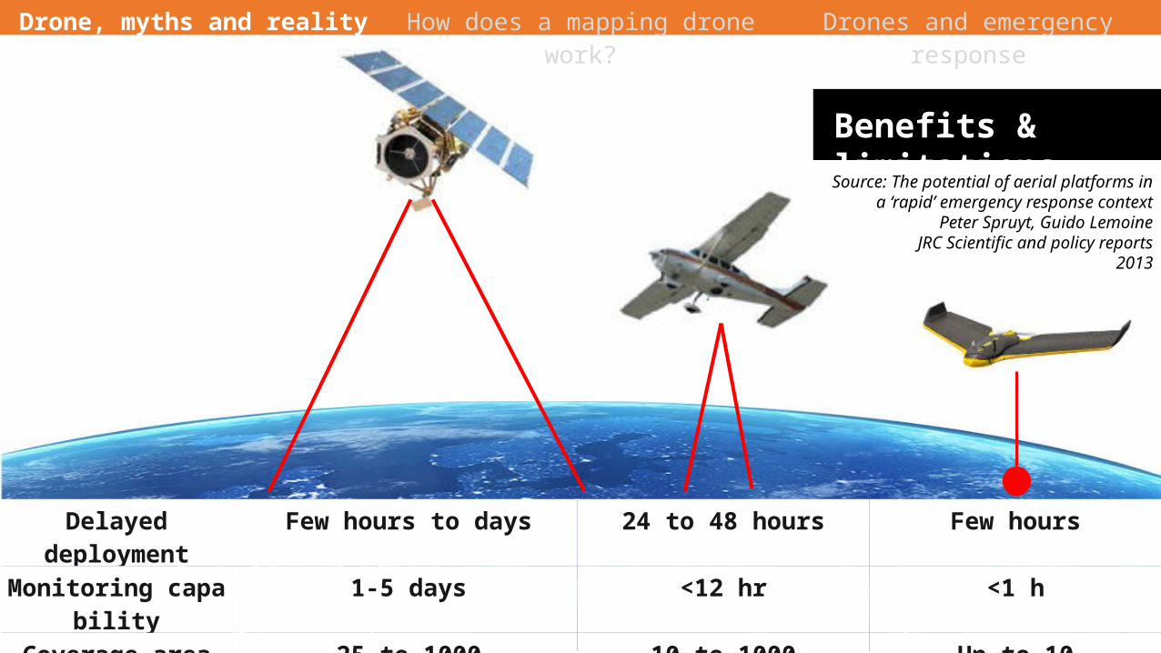
Benefits & limitations
Delayed deployment Few hours to days 24 to 48 hours Few hoursMonitoring capability 1-5 days <12 hr <1 hCoverage area (km²) 25 to 1000 10 to 1000 Up to 10
Spatial resolution >= 50cm/px 3 to 60 cm/px 3 to 15 cm/px
Source: The potential of aerial platforms in a ‘rapid’ emergency response context
Peter Spruyt, Guido LemoineJRC Scientific and policy reports
2013
Drone, myths and reality How does a mapping drone work? Drones and emergency response

13/43
Aerial drones type
Drone, myths and reality How does a mapping drone work? Drones and emergency response

14/43
Rotary Fixed Wind
Civilian Drones
Drone, myths and reality How does a mapping drone work? Drones and emergency response

15/43
Be careful of your local drone’s regulation
Drone, myths and reality How does a mapping drone work? Drones and emergency response

16/43
Agriculture
Mining
Monitoring
Environmental protection
Emergency response
…
https://www.sensefly.com/applications/overview.html
Drone, myths and reality How does a mapping drone work? Drones and emergency response
Drone use cases

17/43
Partie II
How does a mapping drone
work?

18/43
Fully automatedFlies, acquires images
& lands itself
Optimised rangeUp to 50 min flight timeFor coverage of up 12 km2
Super lightweight< 1kg equipment included
On board artificial intelligenceAutomatic safeties procedures
(GPS Loss, strong wind, etc.)
Green technologyBrushless electric motorLow noise, low pollution
Nadir & oblique picturesImages transformed into 2D orthomosaics & 3D models
Drone, myths and reality How does a mapping drone work? Drones and emergency response
A focus on the eBee

19/43
Intuitive planning, monitoring & control software
Drone, myths and reality How does a mapping drone work? Drones and emergency response

20/43
Optical & Infrared
MultiSpectral
Thermal
Mapping Sensors
Drone, myths and reality How does a mapping drone work? Drones and emergency response
Type of sensors
21/43
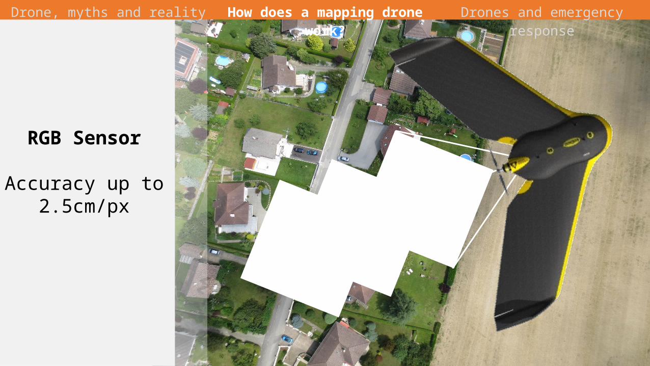
RGB Sensor
Accuracy up to 2.5cm/px
Drone, myths and reality How does a mapping drone work? Drones and emergency response

22/43
Near InfraredSensor
Widely use for for vegetation
analysis
Red Edge SensorWater stress
detection
MultispectralSensor
4 bands (R, G, Nir and red Edge)
in the same time
Drone, myths and reality How does a mapping drone work? Drones and emergency response

23/43
Thermal sensor
water distribution,
check irrigation systems,
assess the functionality
of solar panels
Drone, myths and reality How does a mapping drone work? Drones and emergency response

24/43
Drone, myths and reality How does a mapping drone work? Drones and emergency response
From aerial pictures to …

25/43
Orthophotography(georefrenced
image)
Drone, myths and reality How does a mapping drone work? Drones and emergency response

26/43
Digital Elevation Model
Drone, myths and reality How does a mapping drone work? Drones and emergency response

27/43
Point Cloud
Volumetric computation
3D Modelling
Drone, myths and reality How does a mapping drone work? Drones and emergency response

28/43
Drone, myths and reality How does a mapping drone work? Drones and emergency response
Mapping the impossible

29/43
ADD EXAMPLE
Drone, myths and reality How does a mapping drone work? Drones and emergency response
A concrete example

30/43
Part III
Drones and emergency response
31/43
Drone, myths and reality How does a mapping drone work? Drones and emergency response
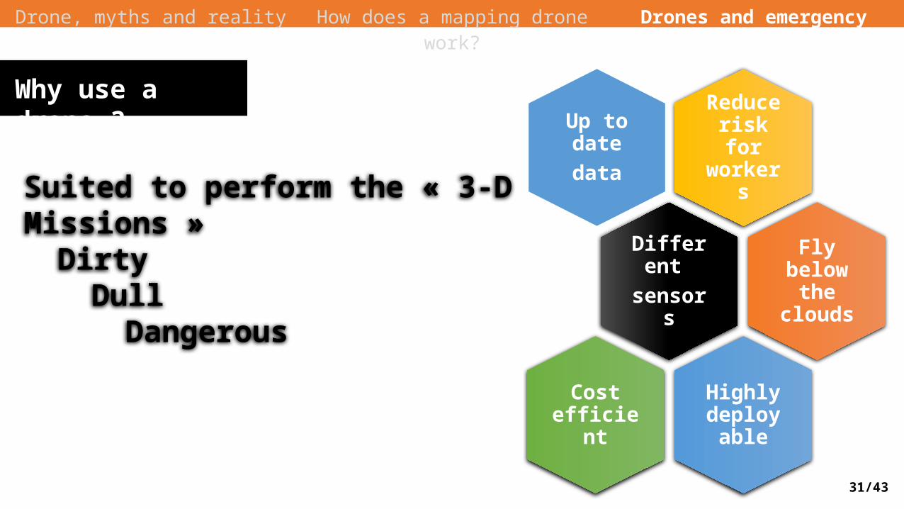
Why use a drone ?Reduce risk for workers
Up to datedata
Different sensors
Fly below the clouds
Highly deployab
le
Cost efficient
Suited to perform the « 3-D Missions »Dirty
DullDangerous
32/43
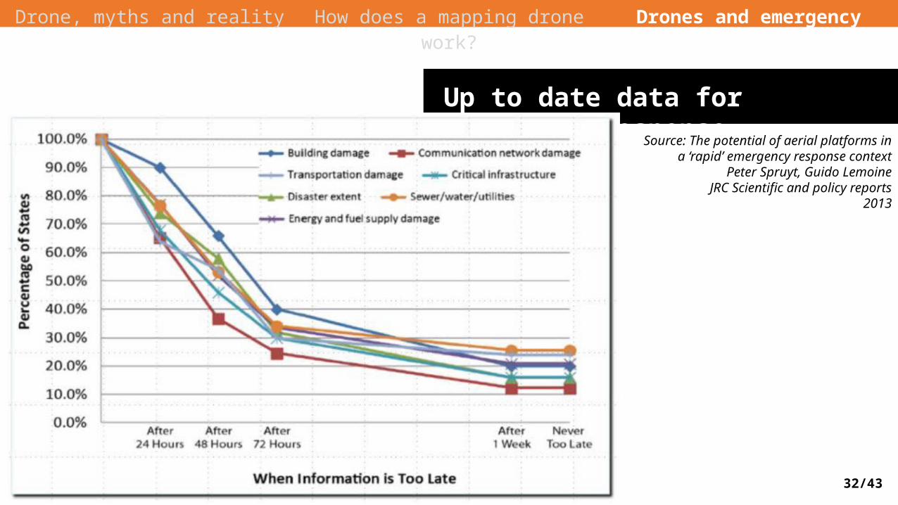
Up to date data for emergency responseSource: The potential of aerial platforms in a
‘rapid’ emergency response contextPeter Spruyt, Guido Lemoine
JRC Scientific and policy reports2013
Useful actionable situation information needs to be integrated in the common operational organization within 24 hours after the event
Drone, myths and reality How does a mapping drone work? Drones and emergency response

33/43
Typical disaster relief lifecycle
Drone, myths and reality How does a mapping drone work? Drones and emergency response
• Temporary Infrastructure / Supply Delivery
• Wildfire – Detection and Extinguishing
• Dealing with Chemical, Biological, …, Explosive (CBRNE) Event
• Search and Rescue Operations
• Reconnaissance and Mapping• Structural integrity
Assessment
• Insurance Claims Response and Risk Assessment
• Logistics Support
Recovery Prevention
PreparationResponse
34/43
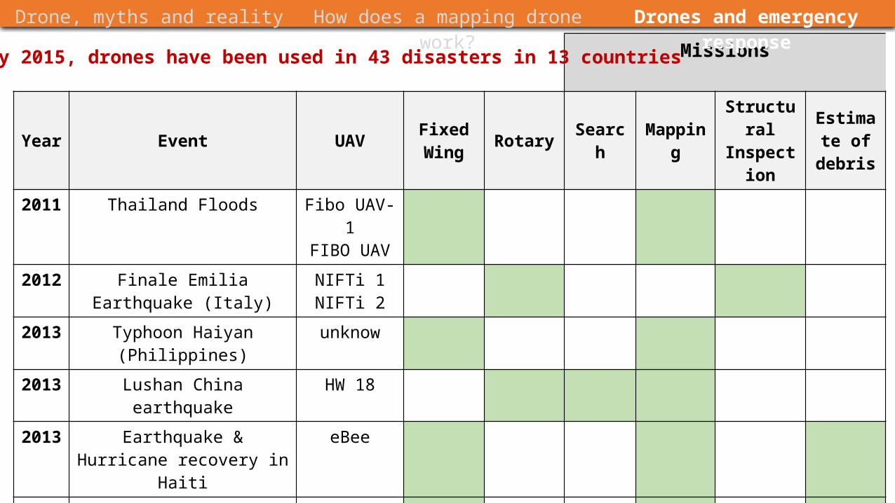
Missions
Year Event UAV FixedWing Rotary Search Mapping Structural
InspectionEstimate of debris
2011 Thailand Floods Fibo UAV-1FIBO UAV
2012 Finale Emilia Earthquake (Italy) NIFTi 1NIFTi 2
2013 Typhoon Haiyan (Philippines) unknow
2013 Lushan China earthquake HW 18
2013 Earthquake & Hurricane recovery in Haiti
eBee
2014 Fukushima Tsunami recovery eBee
2015 Bennet Landfill SC (USA) PrecisionHawk
Drone, myths and reality How does a mapping drone work? Drones and emergency response
In January 2015, drones have been used in 43 disasters in 13 countries

35/43
Drone, myths and reality How does a mapping drone work? Drones and emergency response
Realized by :Drone AdventuresIn coordination with IOM (International Organization for Migration) and OpenStreetMap
45 km² coveredOutputs : Aerial map and 3D Model
Examples of use :3D terrain models of some dangerous ravine was used to perform water-flow simulations and decide where to build infrastructure to mitigate flooding
Haiti Hearthquake
http://droneadventures.org/haiti/#1

36/43
Drone, myths and reality How does a mapping drone work? Drones and emergency response
Fukushima – reconstructions after earthquake & tsunami
http://droneadventures.org/fukushima/#1

37/43
Drone, myths and reality How does a mapping drone work? Drones and emergency response
Realized by :Drone AdventuresIn coordination with Center for Spatial Information Science at the University of Tokyo
Three sites mapped: Lidate village: received some of the highest levels of contamination of radioactive elements
Hisanohama: Highly damaged after the tsunami damage
Tomioka: the closest town from a nuclear wasteland
Fukushima

38/43
Drone, myths and reality How does a mapping drone work? Drones and emergency response

39/43
Drone, myths and reality How does a mapping drone work? Drones and emergency response
Source: Fornace et al. Mapping infectious disease landscapes: unmanned aerial vehicles and epidemiology. Trends in Parasitology, 2014
Study of macaque movements and malaria cases in Malaysia
40/43
Drone, myths and reality How does a mapping drone work? Drones and emergency response
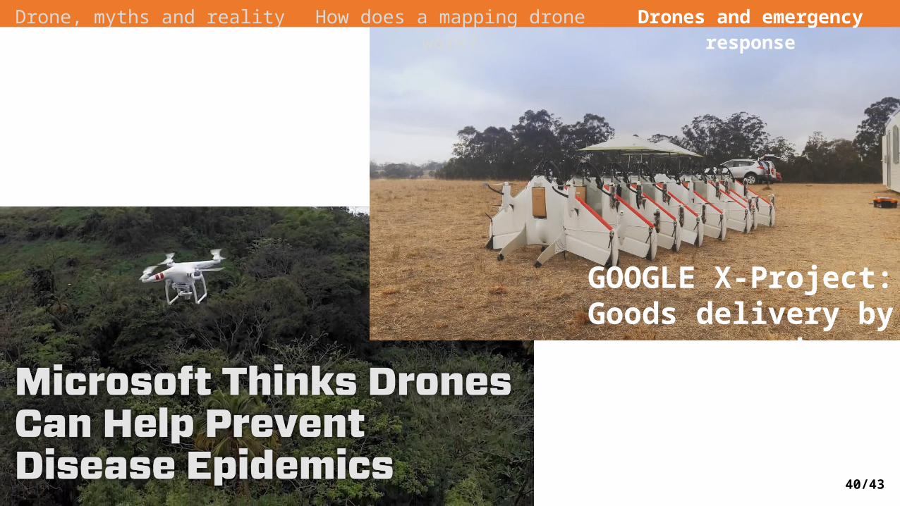
GOOGLE X-Project: Goods delivery by drones

41/43
Study Ecology of pathogens and vectors• High-resolution mapping of the habitats of
pathogens and vectors• Acquisition of data below the cloud cover and at
specific dates:Follow the dynamics of water bodies during
different seasonsPossibility to iterate rapidly the observations
(ex. weekly)
Population exposure• Identify the houses exposed to hazards• Identify social inequalities (from a typology of
housing)
Conclusion
Possible use of drones for health studies
Vector control• Target specific areas for vector control
(such as spray of insecticides), in order to reduce the amount of products sprayed and the exposure of people manipulating products
Health care management• Drug delivery in areas with difficult access

42/43
Green TechnologyAlmost no noiseElectric motor
Relatively affordableYou own your dataMany possible outputs
Easy and fast to deployCan fly under the clouds
Conclusion

43/43
Questions ?Relevant readings
Adams, Stuart M. and Carol J. Friendland , 2014, “A Survey of UAV Usage for Imagery Collection in Disaster Research and Management.”
Adams, Stuart M., Marc Levitan, and Carol Friendland, 2014, “High Resolution Imagery Collection UtilizingUAVs for Post-Disaster Studies.”
Carlos Alphonso F. Ezequiel, 2014, “UAV Aerial Imaging Applications for Post-Disaster Assessment, Environmental Management and Infrastructure Development.”
America Red Cross, 2015, “ Drones for Disaster Response and Relief Operations.”