use of big data, crowdsourcing and gis in assessment of …€¦ · use of big data, crowdsourcing...
TRANSCRIPT

Use of big data, crowdsourcing and GIS in assessment of weather-related impact
PAN Chi-kin, Hong Kong Observatory
November 2017,
KMA/WMO Regional Workshop on Impact-based Forecasts in RA II1(Asia), Seoul, Republic of Korea
HK
(Photo courtesy : GFS)
(Photo courtesy : Roy Liu/China Daily)

Era of big data and crowdsourcing
• Volume of data exploding
• Variety of data increasing
• Possibility of soliciting additional data from public through crowdsourcing
• Problem of information overflow
• Both challenge and opportunity in receiving, processing and using big and crowdsourced data
• Ride on new technologies to reap the full benefit of big data and crowdsourcing for DRR

The Hong Kong
Observatory (HKO)
making regular
meteorological
measurement for over
130 years since 1883
Observations in early
days confined mostly to
coastal region
Weather map in 1909
Meteorological Data - THEN

Meteorological Data - NOW

200 GB Radar & satellite
data
Numerical weather
prediction model
output
1.06 TB
Local weather
observations
20 GB
Meteorological data
exchanged from other
weather services
6 GB
• Daily total ~ 1,300,000,000,000 bytes (1.3 TB)
BIG DATA at Hong Kong Observatory
Key Challenges Enormous growth of meteorological big data
Forecasters overwhelmed by the sea of weather data
Emergence of crowdsourced weather data
Weather observations shared by public
Unstructured format with varying quality
Emergence of social media
Spread of photos, videos, views & rumours (!)
Weather information becoming a commodity
Free weather observations/forecasts from websites, smartphones,
TV
People not only asking for what the weather will be like but what it
will do to them (impact)

Turning Challenges into Opportunities - Big Data Applications in HKO

Weather Monitoring using Expert System
Intelligent Meteorological Monitoring Assistant (IMMA) to support weather analysis and monitoring
Automatic processing : turning weather data into intelligence for forecaster

9
HK
“Heavy rain reported in Guangdong, rainfall nowcast system also suggested possible heavy rain shortly. Please consider the need for a RED Rainstorm Warning”
“Relative humidity dropped to a rather low level in upstream region, please consider the need for a Fire Danger Warning”
“Historical record of maximum temperature at HKO just broken”.
Sample Advice from IMMA

Major Capabilities of IMMA Provide alert of severe weather in neighbouring areas
Detect record-breaking events in Hong Kong
Provide alert of emerging weather conditions that may be
inconsistent with forecast / warnings in effect (e.g. high winds
from cyclones but no tropical cyclone warning signal)
Enhance situational awareness
Performance of IMMA
530,000+ data points processed every minute
7-8 seconds to perform cycle run once every 5 minutes
300+ conditions in support of ~250 production rules for advice
generation
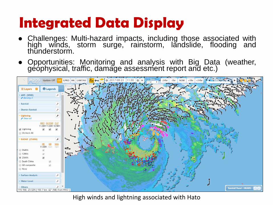
Integrated Data Display Challenges: Multi-hazard impacts, including those associated with
high winds, storm surge, rainstorm, landslide, flooding and thunderstorm.
Opportunities: Monitoring and analysis with Big Data (weather, geophysical, traffic, damage assessment report and etc.)
High winds and lightning associated with Hato

• 2017-08-23 integrated display of winds, topography and fallen
trees ( ) can clearly depict the combined effects of wind
force & direction, and sheltering.
Hato brought damaging winds to Hong Kong
Up to 08H : 5 reports of fallen trees
Up to 11H: 101 reports of fallen trees

• The storm surge brought by Hato raised the water level in Hong Kong
generally by about one to two metres. Coinciding with the high water of the
astronomical tide, the aggregated effect resulted in unusually high water level
and serious flooding( ) in many low-lying areas of Hong Kong.
Storm Surge induced by Hato
Measured water level
Astronomical tide
2017-08-23 16:00H

Crowdsourced Weather Data Community Weather Information Network (Co-WIN)
Established in 2007 to collect crowdsourced weather data in collaboration with local universities
Schools & community groups operate AWSs at own premises to make observations on temperature, humidity, wind, pressure, rainfall, solar radiation, etc.
Data uploaded in real-time to Co-WIN website
160+ member organizations

Crowdsourced Weather Data Effort further expanded to engage general public in 2011 via
the Community Weather Observing Scheme (CWOS)
Allow sharing of weather observations, photos, videos made conveniently using smartphones
90,000+ contributions collected so far
http://co-win.org/index.php/en/

Embracing the Big Data Era - Projects in the Pipeline
Presence on Social Media
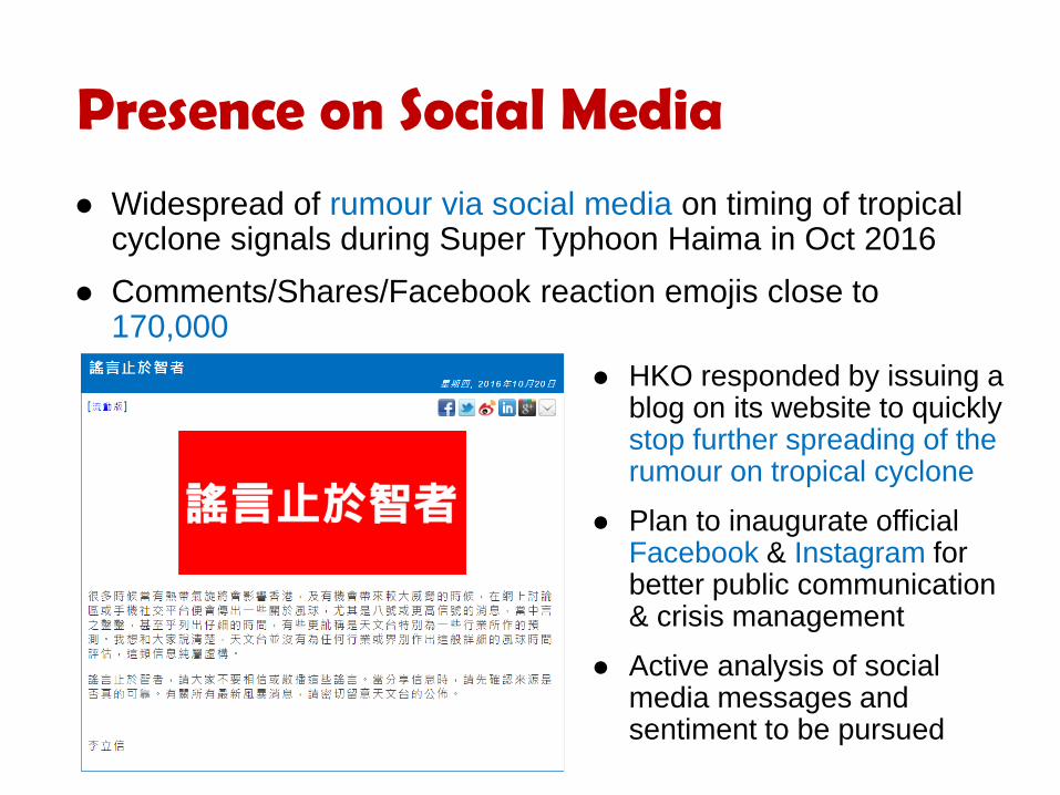
Widespread of rumour via social media on timing of tropical cyclone signals during Super Typhoon Haima in Oct 2016
Comments/Shares/Facebook reaction emojis close to 170,000
HKO responded by issuing a blog on its website to quickly stop further spreading of the rumour on tropical cyclone
Plan to inaugurate official Facebook & Instagram for better public communication & crisis management
Active analysis of social media messages and sentiment to be pursued

The Civil Engineering and Development Department (CEDD), a department of the Hong Kong Government, is developing a ‘Common Operational Picture (COP)’ which
• provides a new map-based common IT platform with Geographic Information System (GIS) functions for sharing real-time emergency and impact information such as landslides, flooding and major road incidents handled by various departments; and
• incorporates related information such as weather information and status of temporary shelters to provide a comprehensive platform for emergency responses.
COMMON OPERATIONAL PICTURE (COP)

• enhancing the common situational awareness of the emergency managers in relevant bureaux and departments and facilitate them to make effective, consistent and timely decisions and mobilize resources.
• facilitating emergency information sharing and support mechanism for dealing with multiple hazards.
• strengthening coordination and enhancing the planning and responsiveness to emergency situations in a holistic manner.
• enabling frontline staff and emergency managers to view the emergency information anytime and anywhere via desktop workstation and mobile devices.
Benefits of Using COP

Concluding Remarks Emergence of Big Data presents both challenges and
opportunities to HKO.
Innovative use of Big Data, including both meteorological and non-meteorological data, offers huge potential in enhancing weather services and “Emergency Preparedness and Response” of government departments, stakeholders and the general public.
Future efforts in developing impact-based weather forecasts will increasingly rely on Big Data technologies.
(Photo courtesy : DSD and CEDD)

Thank you