use of 2d hydrodynamic models for stream restoration
TRANSCRIPT

Use of 2D Hydrodynamic Models for
Stream Restoration Assessment and Design
John S. Schwartz, Ph.D., P.E.
Embarras River, Champaign County, Illinois
The University of Tennessee at Knoxville
Department of Civil and Environmental Engineering
Beaver Creek, Knox County, TN
Ecohydraulics
Approach
Model Basics
CTU-Prague: 143SRPP Seminar 1 Winter 2019 Semester
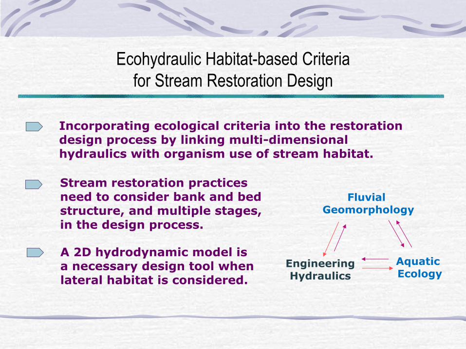
Ecohydraulic Habitat-based Criteria
for Stream Restoration Design
Incorporating ecological criteria into the restoration design process by linking multi-dimensional hydraulics with organism use of stream habitat.
Fluvial Geomorphology
Engineering Hydraulics
Aquatic Ecology
Stream restoration practices need to consider bank and bed structure, and multiple stages, in the design process.
A 2D hydrodynamic model is a necessary design tool when lateral habitat is considered.

Two-Dimensional Hydrodynamic Models
2D hydrodynamic models fundamentally are the same applying the principles of mass and momentum conservation (depth-averaged St. Venant equations), but different in meshing schemes and numerical solution techniques to route mass and momentum.
Steffler (2002)
Two-dimensional (2D) hydrodynamic models are many: River2D, HEC-RAS-2D, RMA-2V, MIKE21, others.
River2D uses a finite element unstructured mesh design.
River2D download site:
http://www.river2d.ualberta.ca/ Freeware

River 2D: A Two-Dimensional Hydrodynamic Model
Model Structure: the operational basics
Three Separate Modules:
1. R2D_Bed.exe --- Used to create a topographic surface 2. R2D_Mesh.exe --- Used to generate a finite element
mesh that lies over the topographic surface to route water mass and momentum from cell to cell
3. River2D.exe --- Performs the hydraulic modeling per topo and mesh files, and given boundary conditions Boundary Conditions – discharge, exit boundary water surface elevation, initial guess at upstream water surface elevation
Computes Steady and Transient Flows (v.95)
Habitat sub-module is in River2D.exe
Steffler (2002)
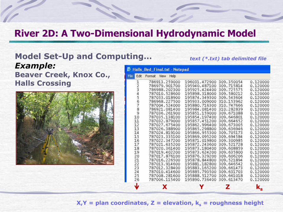
River 2D: A Two-Dimensional Hydrodynamic Model
Model Set-Up and Computing… Example: Beaver Creek, Knox Co., Halls Crossing
X Y Z ks
text (*.txt) tab delimited file
X,Y = plan coordinates, Z = elevation, ks = roughness height

River 2D: A Two-Dimensional Hydrodynamic Model
R2D_Bed.exe --- Used to create a topographic surface
Node/Break-line Editing
Triangulate Function
Display Editing: zoom in/out, scale to fit, scale to point
File Editing
Bed Function: node/break-line editing, edit roughness height, and create model boundaries
Display Function: zoom, show nodes/break-lines, triangulation, contours/color, boundaries, background, annotation options

River2D: R2D_Bed Module
Each node has a unique x, y coordinate, bed elevation, and roughness height (ks)

River2D: R2D_Bed Module
model boundary for flow
define outlet, no flow
boundary and inlet
model nodes turned off
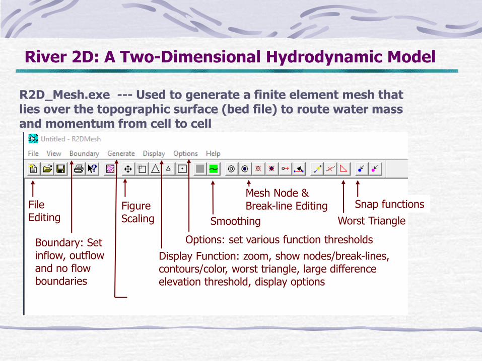
River 2D: A Two-Dimensional Hydrodynamic Model
R2D_Mesh.exe --- Used to generate a finite element mesh that lies over the topographic surface (bed file) to route water mass and momentum from cell to cell
Generate Function: mesh building tools
Snap functions
Worst Triangle
Mesh Node & Break-line Editing File
Editing
Options: set various function thresholds
Display Function: zoom, show nodes/break-lines, contours/color, worst triangle, large difference elevation threshold, display options
Smoothing
Figure Scaling
Boundary: Set inflow, outflow and no flow boundaries

River2D: R2D_Mesh Module
finite element mesh
unstructured grid

River2D: R2D_Mesh Module
QI > 0.2

River 2D: A Two-Dimensional Hydrodynamic Model
River2D.exe --- Performs the hydraulic modeling per topo and mesh files, and given boundary conditions
Hydrodynamics: edit model boundaries, model run inflow and outflow conditions; hydraulic run functions
Habitat: Weighted Usable Area
Triangulate, Smoothing, Mesh/Node Editing
Display Editing: zoom in/out, scale to fit, scale to point
File Editing
Display Function: zoom, show nodes/numbers, contours/color, boundaries, velocity vectors, annotation options

River2D.exe Hydraulic Module
vector output
minimal osculating fast-slow patterns

Q = 3.10 m3/s
River2D Model Example Output
2/3 bankfull flow
Embarras River, Champaign County, Illinois

Q = 0.95 m3/s
Verification of River2D Model Output
1/3 bankfull flow
Embarras River Meandering Reach
Vertification - River2D Model Output
0
0.2
0.4
0.6
0.8
1
12.0 13.0 14.0 15.0 16.0 17.0
Distance (m) Cross-Section 6
Velo
cit
y (
m/s
)
field model
Vertification - River2D Model Output
0
0.2
0.4
0.6
0.8
10.0 11.0 12.0 13.0 14.0 15.0 16.0
Distance (m) Cross-Section 7
Velo
cit
y (
m/s
)
field model
depth-averaged, downstream velocities

River2D Model – Exercise 1
Learn basic model functions for bed mesh, and hydraulic modeling modules.
Use Embarras River topo and ks data provided in file:
EmbarHS.bed
Topographic file has been smoothed with CAD Photos: Embarras River Champaign County, IL