u.s. department of homeland security united states coast ... · for more details or comments...
TRANSCRIPT

12 December 201850/18LNM:
11Coast Guard DistrictPage 1 of 18
U.S. Departmentof Homeland Security
United StatesCoast Guard
LOCAL NOTICE TO MARINERS
CORRESPONDENCE TO:COMMANDER
DISTRICT ELEVEN (DPW)COAST GUARD ISLAND BUILDING 50-2
ALAMEDA, CA 94501-5100
REFERENCES: COMDTPUB P16502.6, Light List Volume VI, 2017 Edition, U.S. Chart No.1 12th Edition, and Coast Pilot Volume 7 49th Edition. These publications, along with corrections, are available at: https://nauticalcharts.noaa.gov/
BROADCAST NOTICE TO MARINERS - Information concerning aids to navigation and waterway management promulgated through BNM HB-0016-18, SF-0188-18, LA-0173-18, and SD-0115-18 have been incorporated in this notice, or will continue if still significant.
SECTION I - SPECIAL NOTICESThis section contains information of special concern to the Mariner.
SUBMITTING INFORMATION FOR PUBLICATION IN THE LOCAL NOTICE TO MARINERS
BRIDGE INFORMATION- PROJECTS, DISCREPANCIES, CORRECTIONS & REGULATORY
BRIDGE INFORMATION-COMMUNICATIONS PROTOCOL-BENICIA/MARTINEZ UPRR BRIDGE- CARQUINEZ STRAIT
CAUTION TO BE USED IN RELIANCE UPON AIDS TO NAVIGATION
Discontinuation of NWS High Seas and Storm Warnings over NIST Time Frequency Broadcasts Effective January 31, 2019.
A complete set of guidelines with examples and contact information can be found at http://www.pacificarea.uscg.mil/Our-Organization/District-11/Prevention-Division/LnmRequest/ or call BM1 Silvestre Suga at 510-437-2980 or e-mail [email protected]. Please provide all Local Notice to Mariners submissions 14 days prior to the start of operations.
For all bridge related issues, including lighting, operation, obstructions, construction, demolition, etc. contact the Eleventh Coast Guard District Bridge Administrator 24 hour cell phone at 510-219-4366. Flotsam may accumulate on and near bridge piers and abutments. Mariners should approach all bridges with caution. A vessel delay at a drawbridge may be reported to the District Bridge Administrator by telephone, or by using the Delay_Report_11-2017.pdf included in the Enclosures section of this Local Notice to Mariners.
All mariners requiring a bridge lift at the Benicia-Martinez Union Pacific Railroad Bridge, mile 7.0, over the Carquinez Strait, California, should follow the protocol in the document entitled “Coordination of Communications for Union Pacific Railroad Lift Operations." Mariners can download a copy of the document by selecting the link BENICIA-MARTINEZ RR BRIDGE under the QUICK LINKS section at https://www.pacificarea.uscg.mil/vtssf.
The aids to navigation depicted on charts comprise a system of fixed and floating aids to navigation with varying degrees of reliability. Prudent mariners will not rely solely on any single aid to navigation, particularly a floating aid to navigation. With respect to buoys, the buoy symbol is used to indicate the approximate position of the buoy body and the sinker which secures the buoy to the seabed. The approximate position is used because of the practical limitations in positioning and maintaining buoys and their sinkers in precise geographical locations. These limitations include, but are not limited to, inherent imprecision in position fixing methods, prevailing atmospheric and sea conditions, slope of and the material making up the seabed, the fact that buoys are moored to sinkers by varying length of chain, and the fact that the buoy body and/or sinker positions are not under continuous surveillance, but are normally checked only during periodic maintenance visits which often occur more than a year apart. Due to the forces of nature, the position of the buoy body can be expected to shift inside and outside the charted symbol. The mariner is also cautioned that buoys may be extinguished or sound signals may not function as the result of natural causes, collisions, or other accidents. For the foregoing reasons, a prudent mariner must not rely completely upon the position or operation of floating aids to navigation, but will also utilize bearings from fixed objects and aids to navigation on shore. Furthermore, a vessel attempting to pass close aboard always risks collision with a yawing buoy or with the obstruction that the buoy marks.
Effective Thursday, January 31, 2019, at: 1300 Eastern Standard Time (EST) or 1800 Coordinated Universal Time (UTC), the National Weather
District: 11 Week: 50/18

12 December 201850/18LNM:
11Coast Guard DistrictPage 2 of 18
MARINE SAFETY INFORMATION BULLETIN
NORTHERN CALIFORNIA-HUMBOLDT BAY-HAZARDOUS CONDITIONS
SOUTHERN CALIFORNIA-SANTA BARBARA CHANNEL-SPEED REDUCTION
Service (NWS) will discontinue dissemination of High Seas and Storm Warnings portion of the National Institutes of Science and Technology (NIST) time frequency broadcasts as issued by WWV and WWVH “shortwave” radio covering the Atlantic, Gulf of Mexico and the Pacific.
This service is being terminated because weather information in the current broadcast format does not support frequent enough updates for changes in marine weather and cannot provide enough detail in the allotted window required by mariners to avoid hazardous weather. Additionally, alternative technologies and numerous media outlets that provide weather information in various formats have overtaken the need for providing weather information through the NIST frequency signals.
Other sources of marine weather and high seas alerts and detailed forecasts are available over satellite, telephone, the Internet, Marine Fax, Radio Fax and VHF radio. Currently the NWS, U.S. Coast Guard (USCG), and the U.S. Navy (USN) provide multiple dissemination methods for storm positioning, high sea areas, observations, forecasts, outlooks and warnings for both coastal and oceanic marine zones near the United States using Navigational Telex (NAVTEX), Global Maritime Distress and Safety System (GMDSS) and High Seas SImplex Teletype Over Radio (HFSITOR) in compliance with World Meteorological Organization (WMO) policies and the International Safety of Life at Sea (SOLAS) Convention.
Please refer to the following websites for more information on how to use these technologies:1. http://www.nws.noaa.gov/om/marine/navtex.htm (NAVTEX) 2. http://www.nws.noaa.gov/om/marine/gmdss.htm (GMDSS) 3. http://www.nws.noaa.gov/om/marine/hfsitor.htm (HFSITOR) 4. http://www.nws.noaa.gov/om/marine/inmarsat.htm (SAFETYNET) 5. http://www.nws.noaa.gov/os/marine/vhfvoice.htm (USCG VHF)
Mariners directing the movement of large ships in or near the offshore approaches to San Francisco Bay have indicated to the Coast Guard that the high-intensity “work-lights” on decks used by commercial fishing vessels prevent vessel operators from seeing the commercial fishing vessel’s navigation lights at night and in low-visibility conditions.
A clear and present threat to navigation safety exists when one vessel cannot see the navigation lights of another vessel. If navigation lights are obscured, the aspect of the latter vessel cannot be determined making it extremely difficult for both vessels to successfully execute the nautical rules of the road. International Navigation Rule 20 states that no other lights that may impair the visibility of the lights specified in the Rules shall be displayed from sunset to sunrise and during periods of low visibility. Vessels found to be in violation of Rule 20 may be subject to a potential $6,500 fine.
All vessels operating near the San Francisco Bay inbound or outbound off-shore traffic lanes are strongly encouraged to comply with the Navigation Rules as they pertain to navigation lights. Vessels are also encouraged to maintain an active listening watch on VHF-FM Chan. 13 and16, when the intentions of another vessel are unclear, communicate to make arrangements to reduce the risk of collision.
Humboldt Bay entrance is observing hazardous conditions with breaking surf that may occur in the vicinity of Humboldt Bay Lighted Buoy 09 (8195). Mariners are requested to transit the area with caution and contact U. S. Coast Guard Sector Humboldt Bay on VHF-FM Chan. 16 for assistance. For more details or comments contact U.S. Coast Guard Sector Humboldt Bay at 707-839-6113.
NOAA Sanctuaries requests a voluntary Vessel Speed Reduction until 30 Dec 18 in the Traffic Separation Schemes in the Santa Barbara Channel and San Pedro Channel. Vessels 300 gross registered tons or larger are encouraged to transit at speeds not in excess of 10kts. These areas contain concentrations of endangered Blue, Humpback, and Fin Whales that are protected under the Federal Endangered Species Act (16 U.S.C. 1538 et seq.), the Marine Mammal Protection Act (16 U.S.C. 1361 et seq.), and the National Marine Sanctuaries Act (16 U.S.C. 1431 et seq.). (See whale zone.pdf in enclosures). Please report any collisions with whales or any observed injured or dead whales to NOAA at 877-SOS-WHALe (877-767-9425) or to the U.S. Coast Guard on VHF-FM Chan. 16. NOAA is asking for the public’s help in tracking whales. Please report sightings through WhaleAlert, a free application available at http://westcoast.whalealert.org.
LNM:
LNM:
LNM:
LNM:
48/18
45/16
50/18
24/18
DISCREPANCIES (FEDERAL AIDS)
SECTION II - DISCREPANCIESThis section lists all reported and corrected discrepancies related to Aids to Navigation in this edition. A discrepancy is a change in the status of
an aid to navigation that differs from what is published or charted.
18649
18622
18720
Chart
Chart
Chart

12 December 201850/18LNM:
11Coast Guard DistrictPage 3 of 18
DISCREPANCIES (FEDERAL AIDS) CORRECTED
DISCREPANCIES (PRIVATE AIDS)
LNM End
LNM End
LLNR
LLNR
Aid Name
Aid Name
Status
Status
Chart No.
Chart No.
BNM Ref.
BNM Ref.
LNM St
LNM St
Dart Tsunami Warning Lighted Buoy Station 46412Point Loma LightNOAA Environmental Lighted Buoy 46028Noonday Rock Lighted Bell Buoy 28
Trinidad Head LightNewport Bay Channel Light 11Isthmus Cove Harbor Reefs Light
San Francisco Main Ship Channel Lighted Bell Buoy 1Yerba Buena Island LightOakland Outer Harbor Light 7
Oakland Outer Harbor Light 9
San Francisco Airport Daybeacon 1Redwood Creek Entrance Light 2
Redwood Creek Light 13
Napa River Light 8Napa River Light 15
San Joaquin River Light 25
Stockton Channel Light 1Sacramento River Deep Water Ship Channel Lighted Buoy 9Sacramento River Deep Water Ship Channel Light 16Sacramento River Deep Water Ship Channel Light 27Sacramento River Deep Water Ship Channel Light 44Sacramento River Deep Water Ship Channel Light 50Bodega Harbor Channel Light 2Bodega Harbor Channel Range C Rear LightBodega Harbor Channel Daybeacon 18
Bodega Harbor Channel Daybeacon 22Bodega Harbor Channel Daybeacon 44
Humboldt Bay Lighted Buoy 9Hookton Channel Light 8Crescent City Harbor Light 9
San Diego Bay Approach Lighted Bell Buoy 4Los Angeles Main Channel Lighted Buoy 10Richmond Harbor Channel Approach Range Rear LightSan Pablo Bay Channel Light 5
Acker Island Light
Sacramento River Deep Water Ship Channel Light 16Sacramento River Deep Water Ship Channel Light 42Humboldt Bay Lighted Buoy 9
ADRIFT
REDUCED INTOFF STA
MISSING
SS INOPSTRUCT DEST/TRLBSTRUCT DEST/TRLB
SINKING
LT EXTSTRUCT DMGD/TRLB
MISSING/TRLB
DAYMK MISSINGSTRUCT DEST/TRLB
STRUCT DMGD/TRLB
STRUCT DEST/TRLBDAYMK MISSING
STRUCT DEST/TRLB
STRUCT DMGDLT EXT
STRUCT DMGD/TRLB
LT EXT
LT IMCH
STRUCT DMGD/TRLB
STRUCT DMGDLT EXT
STRUCT DMGD/TRUB
STRUCT DEST/TRUBSTRUCT DEST/TRUB
OFF STASTRUCT DEST/TRLBSTRUCT DMGD/TRLB
WATCHING PROPERLY
WATCHING PROPERLY
WATCHING PROPERLY
WATCHING PROPERLY
WATCHING PROPERLY
WATCHING PROPERLY
WATCHING PROPERLY
WATCHING PROPERLY
52/16
36/1736/17
44/18
50/1850/1529/18
50/18
50/1823/18
26/18
22/1834/15
41/17
34/1405/17
21/15
22/1750/18
34/18
50/18
50/18
25/17
34/1750/18
50/17
01/1350/15
50/1847/1405/18
39/18
49/18
50/18
49/18
49/18
50/18
50/18
49/18
50/18
50/18
50/18
50/18
50/18
50/18
50/18
50/18
18022
1877318700
18645
186051875418757
18649
1865018650
18650
1865118651
18651
1865418654
18660
1866018660
18660
18661
18661
18661
1864318643
18643
1864318643
186221862218603
18772
18751
18653
18654
18663
18660
18661
18622
1
5275
380
52524702641
4160
45954645
4650
51355180
5240
61656195
6760
69137205
7240
7295
7380
7415
77807850
7865
78857990
819583208386
1493
3118
5675
5885
7015
7240
7370
8195
SD-0168-16
SD-0100-17SF-0194-17
SF-0161-18
HB-0015-18LA-0176-15LA-0094-18
SF-0187-18SF-0089-18
SF-0058-18
SF-0085-18SF-0153-15
SF-0201-17
SF-0123-14SF-0036-17
SF-0083-15
SF-0119-17SF-0188-18
SF-0127-18
SF-0183-18
SF-0186-18
SF-0143-17
SF-0184-17SF-0184-18
SF-0256-17
SF-0069-12SF-0230-15
HB-0016-18HB-0036-14HB-0002-18
SD-0098-18
LA-0168-18
SF-0181-18
SF-0176-18
SF-0177-18
SF-0179-18
SF-0180-18
HB-0014-18

12 December 201850/18LNM:
11Coast Guard DistrictPage 4 of 18
DISCREPANCIES (PRIVATE AIDS) CORRECTED
SECTION III - TEMPORARY CHANGES and TEMPORARY CHANGES CORRECTEDThis section contains temporary changes and corrections to Aids to Navigation for this edition. When charted aids are temporarily relocated for dredging, testing, evaluation, or marking an obstruction, a temporary correction shall be listed in Section IV giving the
new position.
TEMPORARY CHANGES
TEMPORARY CHANGES CORRECTED
LNM End
LNM End
LLNR
LLNR
Aid Name
Aid Name
Status
Status
Chart No.
Chart No.
BNM Ref.
BNM Ref.
LNM St
LNM St
LNM End
LNM End
LLNR
LLNR
Aid Name
Aid Name
Status
Status
Chart No.
Chart No.
BNM Ref.
BNM Ref.
LNM St
LNM St
Scripps Waverider Lighted Research Buoy 092Platform Gail RaconGlorietta Bay Channel Lighted Buoy 8 Coronado Cays Channel Daybeacon 3
Richardson Bay Daybeacon 9San Francisco-Oakland Bay Bridge Pier AFog SignalSan Rafael Rock Quarry Mooring Buoy C
New York Slough Koch West Light
New York Slough Koch East LightDelta Diablo Outfall Lighted Buoy
San Mateo-Hayward Bridge Racon M
OFF STA
RAC INOPLT IMCH
STRUCT DEST
STRUCT DMGDSS INOP
MISSING
LT IMCH
LT EXTBUOY DMGD
WATCHING PROPERLY
45/18
14/1850/18
36/17
23/1815/18
36/18
39/18
39/1839/18
44/18 50/18
18746
1872518773
18773
1864918650
18653
18659
1865918659
18653
158
1871900
2070
44024420
5877.2
6623
66246645.5
5156
None
None
SECTION IV - CHART CORRECTIONS
None
LA-0045-18
SD-0098-17
SF-0086-18SF-0064-18
PLATFORM DISCREPANCIES
PLATFORM DISCREPANCIES CORRECTED
Name
Name
Status
Status
Position
Position
BNM Ref.
BNM Ref.
LNM St
LNM St
LNM End
LNM End
None
None
PLATFORM TEMPORARY CHANGES
PLATFORM TEMPORARY CHANGES CORRECTED
Name
Name
Status
Status
Position
Position
BNM Ref.
BNM Ref.
LNM St
LNM St
LNM End
LNM End
None
None

12 December 201850/18LNM:
11Coast Guard DistrictPage 5 of 18
SECTION V - ADVANCE NOTICESThis section contains advance notice of approved projects, changes to aids to navigation, or upcoming temporary changes such as dredging, etc.
Mariners are advised to use caution while transiting these areas.
SUMMARY OF ADVANCED APPROVED PROJECTS
Approved Project(s) Project Date Ref. LNM
LA/LB LED CONVERSION
NEWPORT BAY-PROPOSED ATON DISCONTINUANCE
The U.S. Coast Guard will permanently changed the Point Vicente Light (LLNR 170) to an LED with a 14nm range December 2018. For more details orcomments contact LT Ruth Sadowitz at 510-437-3801 or [email protected].
The U.S. Coast Guard is discontinuing Newport Bay Channel Light 5 (LLNR 2450), Newport Bay Channel Light 6 (LLNR 2455), Newport Bay Channel Lighted Buoy 8 (LLNR 2460), Newport Bay Channel Light 10 (LLNR 2465), Newport Bay Channel Light 11 (LLNR 2470) and Newport Bay Channel Light 12 (LLNR 2475). The City of Newport has requested to take ownership, remove pile markers and establish lighted Private Aids to Navigation (PATON) buoys for all listed aids in Newport Bay due to concerns of vessel safety and to improve channel marking. For more details or comments contact LT Ruth Sadowitz at 510-437-3801 or [email protected].
LNM:
LNM:
34/15
31/17
SECTION VI - PROPOSED CHANGESPeriodically, the Coast Guard evaluates its system of aids to navigation to determine whether the conditions for which the aids to navigation were
established have changed. When changes occur, the feasibility of improving, relocating, replacing, or discontinuing aids are considered. This section contains notice(s) of non-approved, proposed projects open for comment. SPECIAL NOTE: Mariners are requested to respond in writing to the District
office unless otherwise noted (see banner page for address).
PROPOSED WATERWAY PROJECTS OPEN FOR PUBLIC COMMENT
Proposed Project(s) Closing Docket No. Ref. LNM
SECTION VII - GENERALThis section contains information of general concern to the Mariners. Mariners are advised to use caution while transiting these areas.
A rocky shoal has been reported below the Davis Dam in position 35-11-33.64N 114-34-16.39W where depths are reported between 5’ to less than 1’ depending upon the outflow from the dam. Recreational vessels have been seen running aground after making contact with the rocks as there are no signs or buoys marking the area. Mariners are requested to transit the area with caution. For more details or comments contact USCGSector San Diego at 619-278-7073.
TOPOCK PIPELINE ARCH BRIDGE-PG&E is conducting bridge structural repairs 0600-1630, Monday-Saturday until 21 Dec 18. During work hours, a 25' pontoon boat and a 18' safety boat will be anchored below the bridge, approximately 145' from the California bank. The workboats will be removed from site during off-hours. Mariners are requested to transit the area with caution. For on-site conditions, contact the contractor at 760-219-9659. For more details or comments contact Coast Guard Project Manager at 510-437-3461.
NOAA recommends that mariners take advantage of the most recent chart updates by using the NOAA Electronic Navigational Chart (ENC) for navigation in U.S. waters.ENCs provide the most up to date information, whereas paper and raster nautical chart updates may be up to one month behind the corresponding ENC coverage.Over the next few years, mariners will see continued improvement in the extent and detail of ENC coverage, while there will be a reduction in RNC and paper chart coverage and service. ENCs will include routine changes between editions that are not published through notices to mariners. One significant change to the RNC and paper charts will be the removal of controlling (minimum) depth information from many maintained channels. Controlling channel depths will still be provided on ENCs. Comments or concerns can be addressed through ASSIST, NOAA’s Nautical Inquiry and Comment System. https://www.nauticalcharts.noaa.gov/customer-service/assist/
LNM:
LNM:
16/18
40/18
ARIZONA-BULLHEAD CITY-COLORADO RIVER-DAVIS DAM
ARIZONA-COLORADO RIVER-BRIDGE
NOAA ELECTRONIC NAVIGATIONAL CHART
Chart
Charts: 18020 18022 18740 18746
18754
None
None
None
Advance Notice(s)
Proposed Change Notice(s)

12 December 201850/18LNM:
11Coast Guard DistrictPage 6 of 18
BON AIR RD BRIDGE REPLACEMENT-The City of Larkspur’s contractor, Golden State Bridge, has begun replacement of the existing bridge. A temporary work trestle spans the channel and provides 20’ of horizontal clearance, pile to pile, and 3' of vertical clearance from mean high water to the lowest hittable portion of the trestle (see BonAirRd_Trestle.pdf at the end of this notice for navigation channel location). Four cofferdams have been placed within the creek to facilitate construction of the replacement bridge piers. Work will be conducted Monday through Saturday from 0700-1800. Mariners are requested to transit the area with caution. For conditions at the construction site, mariners can contact the contractor at 925-953-4610/916-919-2428 or the city at 415-259-7050. For more details or comments contact the Coast Guard Bridge Office at 510-437-3516.
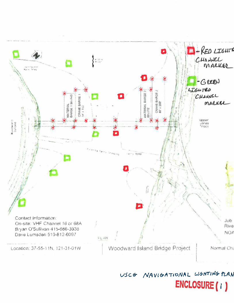
NEW WOODWARD ISLAND BRIDGE CONSTRUCTION-San Joaquin County’s contractor, Dutra, has commenced construction of the new bridge. Work will take place Monday through Saturday, 0700-1700. Two material barges, 50’ x 145’ and 60’ x 175’, and two crane barges, 60’ x 200’ and 54’ x 150’, will be spudded at various locations during construction, monitoring VHF-FM Chan. 15 and 68A, and can be moved for navigational safety if 4.5 hours notification is given to the contractor. After the workday, the barges will be left on-site. The upstream and downstream cornersof each barge will be lighted at night with steady burning red lights. Once installed, each bridge column will be temporarily marked, upstream and downstream, with steady burning red lights. An 80’ wide navigational channel, marked by lighted channel buoys, will be available for vessel passage. (See WoodwardConstruction_Lighting.pdf at the end of this notice for the construction lighting configuration). For more details or comments contact the Coast Guard Bridge Office at 510-437-3461.
TOWER DRAWBRIDGE-The drawspan is secured in the closed-to-navigation position through 01 Jan 19 for wire rope and cable replacement and electrical maintenance. The bridge provides 30 ft of vertical clearance from Mean High Water in the closed-to-navigation position. Vessels that can transit the bridge, while closed, can continue to do so during the work. In the event of an emergency the drawspan can open with a 72-hour notice to the bridge operator. For more details or comments contact the Coast Guard Bridge Office at 510-437-3516.
RIO VISTA DRAWBRIDGE-Temporary platforms under the bridge deck, from the east tower to the east levee, reduces vertical clearance in each span by 4'. The upstream and downstream lower edges of the platforms are lighted at night with steady burning red lights (See RioPlatform_Lighting.pdf at the end of this notice for platform lighting diagram).Temporary 30 ft wide work platforms, installed at various locations below low steel of the lift span, are lighted at night with steady burning red lights. (See Temp_Platform_Lighting.pdf at the end of of this notice for lift span platform lighting,) The temporary platforms under the lift span reduce vertical clearance by approximately 4 ft.
A temporary change in the operating schedule for the bridge is in place through 15 Feb 19 to allow Caltrans to conduct painting and preventative maintenance on the lift span and operating machinery. There are separate temporary operating schedules for Commercial and Recreational vessels. The temporary operating schedule changes are as follows:
For “COMMERCIAL VESSELS” the draw shall open on signal from midnight on Monday through 0700 on Saturday if at least a 4-hour notification is given to the bridge tender. The draw shall open on signal from 0700 on Saturday through 2359 on Sunday when notice is given to the bridge tender.
For “RECREATIONAL VESSELS”, Monday through Friday, 0700 to 1530, the draw need not open for the passage of recreational vessels except between 1100 and noon when the draw shall open on signal when notice is given to the bridge tender. The draw shall open on signal, Monday through Friday, 1530 to 0700 the following morning, if at least a 4-hour notification is given to the bridge tender. The draw shall open on signal from 0700 on Saturday though 2359 on Sunday when notice is given to the bridge tender.
For more details or comments contact the Coast Guard Bridge Office at 510-437-3461.
REPLACEMENT NAVY DR BRIDGE CONSTRUCTION-Construction of the replacement bridge is in progress. Work is conducted Monday through Saturday from 0600 to 1900. Two lanes of the replacement bridge are in place and spans the river. The vertical clearance of the replacement spanis greater than the vertical clearance of the existing downstream railroad drawbridge. A north side temporary trestle is in place and provides 33' ofhorizontal clearance for vessels from the end of the trestle to the southern levee of the river. The depth of water in the temporary channel is approximately 6' at mean high water. The upstream and downstream edges of the trestles, bridge piers, and remaining existing swing span fender will be lighted at night with steady burning red lights so as to be seen at a distance of 500 yards by approaching vessels. (see Navy_Dr_Lighting.pdf in the enclosure section of this notice). For conditions at the bridge, mariners can contact the contractor at 925-200-9175 or760-846-5842. For more details or comments contact the Coast Guard Bridge Office at 510-437-3516.
MCHENRY RD BRIDGE REPLACEMENT-Construction on the replacement bridge continues. For more details or comments contact the Coast Guard Bridge Office at 510-437-3516.
LNM:
LNM:
LNM:
LNM:
LNM:
LNM:
50/18
41/18
30/18
41/18
45/18
35/18
NOAA ELECTRONIC NAVIGATIONAL CHART
NORTHERN CALIFORNIA-CORTE MADERA CREEK-BRIDGE
NORTHERN CALIFORNIA-DELTA & RIVERS-MIDDLE RIVER-BRIDGE
NORTHERN CALIFORNIA-DELTA & RIVERS-SACRAMENTO RIVER-BRIDGE
NORTHERN CALIFORNIA-DELTA & RIVERS-SACRAMENTO RIVER-BRIDGE
NORTHERN CALIFORNIA-DELTA & RIVERS-SAN JOAQUIN RIVER-BRIDGE
NORTHERN CALIFORNIA-DELTA & RIVERS-STANISLAUS RIVER-BRIDGE
Chart
Chart
Chart
Chart
Chart
18649
18661
18662
18661
18661

12 December 201850/18LNM:
11Coast Guard DistrictPage 7 of 18
THREE MILE SLOUGH BRIDGE-The drawspan is secured in the closed-to navigation position due to mechanical failure. The bridge provides 12 ft of vertical clearance at Mean High Water when closed. Vessels that can transit the bridge while closed can continue to do so. Estimated time of repairis unknown.
RAILROAD BRIDGE/MURRAY-EATON BRIDGE-The fender system on both bridges is damaged. Estimated time of repair unknown. For more details or comments contact the Coast Guard Bridge Office at 510-437-3516.
The Monterey Bay Aquarium Research Institute (MBARI) has deployed a research buoy with a planned recovery date of 31 May 19. Buoy is 9', in diameter, yellow and leabeled "MBARI", with antennas, radar reflectors and a light Fl W 1s. The buoy will be located 7nm southwest of Moss landing and will operate within 1200yds of position 36-44-36N 121-53-48W. Mariners are requested to transit the area with caution. For more details or comments contact MBARI at 831-775-1700.
Monterey Bay Aquarium Research Institute (MBARI) will be conducting 24/7 autonomous, unmanned maritime vehicle operations of two Liquid Robotics, Inc. Wavegliders until 31 Dec 18. Vehicles will be deployed in the vicinity of Moss Landing that will operate continuously between latitudes 35-07-12N and 37-12-00N and will extend shoreward as far West as 122-58-35W. Operations consist of scientific ocean data collection. The Waveglider carries no fuel, lubricants or hydrocarbons. It is wave powered and remotely attended from MBARI, moving at speeds of ~1kt, and designed to give way or part if encountered by a vessel. It is approximately 6.5' x 2' (surfboard size), yellow in color, with a contact plaque and mast extending 3' above the water surface, supporting a flag. Mariners are requested to transit the area with caution. For more details or comments contact MBARI at 831-775-1700, [email protected] or Liquid Robotics 24/7 WGOC Operations at 888-574-4574.
EMBARCADERO RD BRIDGE REPLACEMENT-Bridge replacement construction activities are now in progress from 0700-1700, Monday through Friday until 30 Jan 19. Dry cofferdams have been installed to facilitate removal of the existing bridge and construction of the replacement bridge. The contractor will use 3 to 4, 3' X 7.5' X 30', flexi-float barges during the demolition of the eastern pier (see enclosure Embarcadero_Flexi_Float_Lighting.pdf at the end of this notice). A 66' horizontal clearance for vessels will be maintained during construction. Mariners are requested to transit the area with caution when transiting the work site. For on-site conditions contact the contractor at 707-310-0631 and City of Oakland at 510-615-5566 after hours. For more details or comments contact the Coast Guard Bridge Office at 510-347-3515.
The USGS Pacific Coastal and Marine Science Center (PCMSC) will be conducting geophysical surveys in Ocean Beach, CA until 17 May 19 0700-1800. The survey area is bounded by the following coordinates:37-46-36N 122-31-47W37-42-35N 122-31-47W 37-46-36N 122-30-11W37-42-35N 122-30-11W A bathymetric survey using two personal watercraft, each equipped with a 200 kHz single beam echo sounder will be used to conduct survey operations within the surf zone. The watercrafts will monitor VHF-FM Chan. 16 and 82a. Mariners are requested to transit the area with caution. For more details or comments contact Tim Elfers at 831-460-7544.
BLACKPOINT RAILROAD DRAWBRIDGE-The upstream fender system protecting the swing span has been destroyed and does not offer protection for vessels or the bridge. Mariners are urged to use caution while transiting the bridge.
BLACKPOINT HIGHWAY 37 BRIDGE-The fenders channelward side of the western pier are damaged. Estimated time of repair unknown.
For more details or comments contact the Coast Guard Bridge Office at 510-437-3516.
Overhead power cables upstream of Sacramento River lights 11 and 12 at 38-03-54N 121-47-09W have a reported reduced vertical clearance to 119.5'.
LNM:
LNM:
LNM:
LNM:
LNM:
LNM:
LNM:
LNM:
LNM:
35/18
50/18
06/18
45/18
26/18
20/16
47/18
10/18
22/16
NORTHERN CALIFORNIA-DELTA & RIVERS-STANISLAUS RIVER-BRIDGE
NORTHERN CALIFORNIA-DELTA & RIVERS-THREE MILE SLOUGH-BRIDGE
NORTHERN CALIFORNIA-MONTEREY BAY-SANTA CRUZ HARBOR-BRIDGE
NORTHERN CALIFORNIA-MOSS LANDING-BUOY DEPLOYMENT
NORTHERN CALIFORNIA-MOSS LANDING-WAVEGLIDER DATA COLLECTION
NORTHERN CALIFORNIA-OAKLAND INNER HARBOR-LAKE MERRITT CHANNEL-BRIDGE
NORTHERN CALIFORNIA-OCEAN BEACH-GEOPHYSICAL SURVEY
NORTHERN CALIFORNIA-PETALUMA RIVER-BRIDGE
NORTHERN CALIFORNIA-SACRAMENTO RIVER-REDUCED VERTICAL CLEARANCE
NORTHERN CALIFORNIA-SAN FRANCISCO BAY- MARINE CONTRUCTION
Chart
Chart
Chart
Chart
Chart
Chart
Chart
Charts:
18661
18685
18685
18685
18649
18645 18649
18654
18660

12 December 201850/18LNM:
11Coast Guard DistrictPage 8 of 18
Manson Construction Co. is conducting marine construction at San Francisco Structure and Ferry Plaza Deck during weekdays from 0600-1800 until31 Dec 18. Derrick barge EINAR will be on scene monitoring VHF-FM Chan. 13, 16, and 68. Mariners are requested to transit the area with caution and minimize wake in the vicinity of the construction site. For more details or comments contact Project Manager Mr. Chris Schaeffer at 562-533-3708.
GOLDEN GATE BRIDGE-The Golden Gate Bridge District’s contractor, Shimmick/Danny’s Joint Venture, has begun installing four 54’ temporary underdeck platforms, two ~1900’ north of the south tower and two ~1900’ south of the north tower. Once installed, vertical clearance at the bridge will be reduced in those locations by no more than 14’. As the work progresses, the two outer platforms will be moved towards the towers and the twoinner platforms moved towards the centerline of the bridge. The temporary platforms will be lighted at night with all-round red lights (see PlatformLighting_GG_Bridge.pdf at the end of this notice to see the lighting plan and initial locations of the temporary platform). Work is being conducted Monday through Saturday, 0700-1700 and 2100-0500. For conditions at the bridge, mariners can contact the bridge owner at 415-923-2220 or the contractor at 415-716-0384. For more details or comments contact the Coast Guard Bridge Office at 510-437-3516.
DUMBARTON RAILROAD BRIDGE-The following navigational lights on the bridge are extinguished; the upstream and downstream east side red pierand channel axis lights, the downstream swing span red pier protection light, and the downstream and center swing span red/green alternating lights on top of the superstructure. Estimated time of repair is unknown. For further information, contact the Coast Guard Bridge Office at 510-437-3516.
THIRD STREET DRAWBRIDGE-Until 01 Oct 19, the drawspan will be secured in the closed-to-navigation position for rehabilitation. Scaffolding is installed underneath the length of the drawspan, and will be marked with steady burning red lights at night. A 20ft wide navigational opening closeto the south bank between piers 4 and 6 will be available for small craft to transit through the bridge. The navigational opening will provide a vertical clearance of 3ft over mean high water, and be marked with steady burning green lights at night (see enclosure 3rdSt_PlatformLighting.pdf at the end of this notice). For more details or comments contact the Coast Guard Bridge Office at 510-437-3461.
Deteriorating concrete pilings above and below the waterline are present in the vicinity of the the south edge of Southampton Shoal Light (LLNR 5480). Mariners are requested to transit the area with caution. For more details or comments contact LT Ruth Sadowitz at 510-437-3801 or [email protected].
Dutra Group will be conducting emergency dredge operations near Chevron Long Wharf at 37-55-19N 122-24-40W 24 hours a day 7 days a week until 31 Dec 18. Dredged material will be disposed of at the Montezuma Wetlands. Clamshell dredges DB 24 and/or BEAVER; along with tugs HEIDI BRUSCO, BECKY T, ARTHUR BRUSCO and or SARAH REED will be on site monitoring VHF-FM Chan. 13, 14, and 80. Mariners are requested to transit the area with caution. For more details or comments contact Dredge Superintendent Dennis Salyers at 415-497-5289.
Dutra Group will be conducting dredge operations at the WETA South San Francisco Terminal from 0900-1615 Monday-Friday until 15 Jan 19. Dredged material will be disposed of at the SF-DODS disposal site. Clamshell dredges DB 24, DB BEAVER, or 390 BARGE will conduct dredge operations; along with tugs HEIDI BRUSCO or ARTHUR BRUSCO. Support tender tug SEA W will also be on scene. All vessels on site will monitor VHF-FM Chan. 13, 14, and 82. Mariners are requested to transit the area with caution. For more details or comments contact Dredge Superintendent Dennis Salyers at 415-497-5289.
Camenzind Dredging Inc. will conduct maintenance dredge operations in the Stockton Deep Water Ship Channel from 24 hours a day 7 days a week untill 31 Dec 18. Dredge operations will start at 37-58-00N 121-22-25W and finishing at 37-57-12N 121-18-50W. Floating submerged pipelinewill be marked with yellow floats; anchors are marked with white buoys. Dredged material will be disposed of at the Rough and Ready Island Upland Disposal Site. Dredge PAUL VINCENT, work boat FESTER, and skiffs WALRUS and SILVER will be on scene. All vessels on scene will monitor VHF-FM Chan. 13, 14, 16, and operating on 67. Mariners are requested to transit the area with caution. For more details or comments contact Kurt Camenzind at 650-444-8453.
Ross Island Sand & Gravel Co. will conduct dredge operations in Stockton Deep Water Ship Channel 24 hours a day, 7 days per week until 15 Dec 18. Submerged dredge pipe will come ashore first at 38-04-11N 121-40-30W and the second will be at 38-06-21N 121-36-56W. D/V DREDGE 8 will start dredging at 38-03-36N 121-40-47W and end at 38-05-55N 121-35-29W. D/V DREDGE 8 will be monitoring VHF-FM Chan. 13, 16, and 79. Mariners are requested to transit the area with caution. For more details or comments contact Rod Oliva at 503-349-7436.
LNM:
LNM:
LNM:
LNM:
LNM:
LNM:
LNM:
LNM:
20/18
32/18
49/18
30/18
23/15
50/18
43/18
43/18
NORTHERN CALIFORNIA-SAN FRANCISCO BAY- MARINE CONTRUCTION
NORTHERN CALIFORNIA-SAN FRANCISCO BAY-BRIDGE
NORTHERN CALIFORNIA-SAN FRANCISCO BAY-BRIDGE
NORTHERN CALIFORNIA-SAN FRANCISCO BAY-CHINA BASIN-BRIDGE
NORTHERN CALIFORNIA-SAN FRANCISCO BAY-DETERIORATING CONCRETE PILINGS
NORTHERN CALIFORNIA-SAN FRANCISCO BAY-DREDGE OPERATIONS
NORTHERN CALIFORNIA-SAN FRANCISCO BAY-DREDGE OPERATIONS
NORTHERN CALIFORNIA-SAN FRANCISCO BAY-DREDGE OPERATIONS
NORTHERN CALIFORNIA-SAN FRANCISCO BAY-DREDGE OPERATIONS
Chart
Chart
Chart
Chart
Chart
Chart
Chart
Chart
18649
18649
18651
18649
18649
18653
18651
18663
12 December 201850/18LNM:
11Coast Guard DistrictPage 9 of 18
Ross Island Sand & Gravel Co. will conduct dredge operations in Stockton Deep Water Ship Channel 24 hours a day, 7 days per week until 31 Dec 18. Submerged dredge pipe will come ashore first at 38-03-49N 121-33-42W. D/V DREDGE 8 will start dredging at 38-03-47N 121-33-30W and end at 38-02-54N 121-30-16W. D/V DREDGE 8 will be monitoring VHF-FM Chan. 13, 16, and 79. Mariners are requested to transit the area with caution. For more details or comments contact Rod Oliva at 503-349-7436.
R.E. Staite Engineering Inc. will conduct marine construction and dredge operations on the Napa River in position 38-05-58N 122-15-47W until 30 Dec 18. Marine construction and dredge operations will be conducted by D/V DB 24 with scows HB 46 and HB 47. Dredged material will be disposed of at upland disposal at Montezuma Wetlands restoration Site at Suisun Marsh. All vessels will monitor VHF-FM Chan. 16. Mariners are requested totransit at lowest safe speed to minimize wake and proceed with caution after passing arrangements have been made. For more details or comments contact project manager Jeff Casey at 415-559-5452.
There will be a pyrotechnics event involving a barge conducting a fireworks display near the ferry building in San Francisco, CA at 37-47-45N 122-23-15W from 2359 31 Dec 18 until 0015 01 Jan 19. Mariners are requested to transit the area with caution. For more details or comments contact LT E. Rowan at 415-399-7443.
USGS Pacific Coastal and Marine Geology Science Center (PCMGSC) will be conducting a geophysical surveys in the vicinity of Cache Slough and Sacramento shipping channel during daylight hours until 15 Dec 18. Operations will include a bathymetric survey with R/V PARKE SNAVELY and two 36’ personal watercrafts, each equipped with a 200 khz single-beam echo sounder. R/V PARKESNAVELY will monitor VHF-FM Chan. 16. Mariners are requested to transit the area with caution. For more details or comments contact Tim Elfers at 831-460-7479.
Shoaling has been reported on the south side of Oakland Inner Harbor South Channel in the east passage through the Fruitvale Ave. Bridge. Mariners are requested to transit the area with caution and report any observed changes in shoaling conditions to the San Francisco VTS on VHF-FM Chan. 14. For more details or comments contact U.S. Coast Guard Sector San Francisco Waterways Management at 415-399-7443.
Shoaling has been reported east of Petaluma River Entrance Channel Daybeacon 3 (LLNR 5985) in position 38-03-33N 122-27-06W. Shoaling has been reported to be as shallow as 6 inches up to 15 yards east of the aid. Mariners are requested to transit the area with caution. For more details or comments contact LT Ruth Sadowitz at 510-437-3801 or [email protected].
LWB2 in San Francisco main ship channel located at 37-45-48N 122-37-44W is transmitting an improper signal. Mariners are requested to transit the are with caution. For more details or comments contact LT Sadowitz 510-437-3801.
NOAA, in partnership with Saildrone, Inc., will be conducting fisheries acoustic survey operations using a Saildrone Unmanned Surface Vehicles, launched from Alameda, CA on 10 Aug 18 to survey along the inner shelf between Pt. Reyes and Point Conception. Once the vehicle reaches PointConception, it will repeat a transect line extending WSW from Point Conception out 200 nautical miles until 04 Feb 19. The Saildrone is a 23' sailing vehicle, painted orange and remotely operated. The Saildrone will operate 24/7 collecting acoustic data. Mariners are requested to transit the areawith caution and maintain a 500 meter separation from the Saildrone. For more details or comments about NOAA missions contact Mr. John Crofts 858-546-7150 or email [email protected]. For more details or comments about Saildrone operations contact Saildrone, Inc. 415-670-9700 or [email protected].
REPLACED SAN FRANCISCO/OAKLAND BAY BRIDGE-EAST OF YBI-Work continues on converting piers "G" (E2) and E21-E23, for pedestrian access. Work is being conducted 0600 to 1800, Monday through Friday, occasionally Saturday and Sunday, though 31 Jan 19. Either the derrick barge (DB) HAGAR, 150' X 60'; DB OAKLAND, 140' X 70'; or the DB VANCOUVER, 210' X 60', will be anchored/moored in and around the piers. The barges will be left on-scene, unmanned, after the normal workday. If requested, the barges can be moved for the safety of navigation. A temporary trestle has been installed at the Oakland shoreline to pier E22. A temporary gangway has been installed from the YBI shoreline to pier "G" (E2) and 2-10' X 40' spudded flexi-floats just north of pier "G" (E2). The upstream and downstream edges of the temporary trestle and each corner of each barge and flexi-floats are lighted at night with steady burning all-round red lights, visible at 2,000 yards from approaching vessels (See enclosures Barge-Trestle-Lighting_Retention.pdf at the end of this notice for barge locations and lighting plans.) For conditions at the
LNM:
LNM:
LNM:
LNM:
LNM:
LNM:
LNM:
LNM:
LNM:
42/18
49/18
41/18
50/18
42/18
16/15
41/18
44/18
31/18
NORTHERN CALIFORNIA-SAN FRANCISCO BAY-DREDGE OPERATIONS
NORTHERN CALIFORNIA-SAN FRANCISCO BAY-DREDGE OPERATIONS
NORTHERN CALIFORNIA-SAN FRANCISCO BAY-DREDGE OPERATIONS-MARINE CONSTRUCTION
NORTHERN CALIFORNIA-SAN FRANCISCO BAY-FIREWORKS DISPLAY
NORTHERN CALIFORNIA-SAN FRANCISCO BAY-GEOPHYSICAL SURVEY
NORTHERN CALIFORNIA-SAN FRANCISCO BAY-OAKLAND INNER HARBOR-SHOALING
NORTHERN CALIFORNIA-SAN FRANCISCO BAY-PETALUMA RIVER
NORTHERN CALIFORNIA-SAN FRANCISCO-AIS IMPROPER TRANSMISSION
NORTHERN CALIFORNIA-SAN FRANCISCO-NOAA SURVEY OPERATIONS
NORTHERN CALIFORNIA-SAN FRANCISCO-OAKLAND BAY BRIDGE (EAST OF YBI)
Chart
Chart
Chart
Chart
Chart
Chart
Chart
Charts:
Charts:
18660
18660
18655
18655
18010 18661 18662
18650
18654
18649
18640 18680 18700

12 December 201850/18LNM:
11Coast Guard DistrictPage 10 of 18
construction site, mariners can contact the contractor at 510-773-7803, 360-580-3708, 925-326-0768 or Caltrans at 510-772-7895, 510-714-7074, 510-385-6915.To recover a breakaway barge contact 415-495-3191. For more details or comments contact the Coast Guard Bridge Office at 510-437-3516.
The Coast Guard has been unable to dis-establish the seasonal sound signal for San Pablo Bay Channel Light 15 (LLNR 5940) in accordance with published operational timelines due to the protection of nesting osprey in position 38-03-32N 122-17-27W. Sound signal will be dis-established as soon as allowable. Mariners are requested to transit the area with caution. For more details or comments contact Aids to Navigation Team San Francisco at 415-399-3517.
BAY FARM ISLAND HIGHWAY BRIDGE-The south side lower slat on the fender system is missing and metal bolts are exposed. Mariners are urged to transit the bridge with caution. Estimated time of repair, unknown. For more details or comments contact the Coast Guard Bridge Office at 510-437-3514.
Trans Bay Cable LLC owns and operates a charted submarine cable that experiences intermittent exposures in San Pablo Bay. All vessels are advised not to anchor, use ground tackle, fish, or dredge in the vicinity of 38-03-27N 122-16-22W as this increases the risk of damage violating 47USC 2. Mariners are requested to transit the area with caution. For more details or comments contact Trans Bay Cable Operations Center at [email protected] or 925-427-9744.
There are submerged piles partially exposed above the sediment surface south of Pinole Shoal Channel along the 30' contour between 38-03-14N 122-16-26W and 38-03-18N 122-16-15W. The piles are present along the slope of the natural shoal at heights ranging from approximately 1' to 5' above the sediment surface. For more details or comments contact Todd Muelhoefer of Coscol Petroleum Corporation at 719-520-4761.
Santa Cruz Harbor is cautioning mariners of possible hazardous conditions with breaking surf and shoaling that may occur at Santa Cruz Harbor Entrance due to high surf and extreme tidal conditions in the vicinity of 36-57-37N 122-00-06W. Mariners are requested to transit the area with caution. For more details or comments contact Santa Cruz Harbor on VHF-FM Chan. 09 and 16 or at 831-475-6161.
The United States Navy, Naval Postgraduate School, Oceanography Department have deployed sub-surface oceanographic instrument moorings until 01 Nov 21. These Sub-surface moorings are part of the Monterey Bay and Channel Islands Sound Scape Monitoring Project. These sub-surface moorings are located at the following coordinates:36-47-53N 121-58-34W36-38-53N 121-54-30W34-02-38N 121-54-30W34-05-08N 120-31-24W33-50-56N 120-07-06W34-01-06N 119-19-00W36-22-13N 122-18-53WMariners are requested to transit the area with caution. For more details or comments contact Keith Wycoff at 831-656-2567.
California Department of Water Resources will be operating the boat locks at its Suisun Marsh Salinity Control Structure, located 2.2 nautical miles from the easterly end of Montezuma Slough at position 38-05-36N 121-53-07-W, until 31 May 19. Flashboards will be installed across the maintenance channel and vessels passing this structure must use the boat lock. A boat lock operator will be on duty every day. The boat lock signal is a standard traffic light. Whistle signals to request opening are two prolonged blasts followed by two short blasts. VHF-FM Chan. 13 will be monitored during hours of operation. Full instructions on passage including an emergency phone number are posted at the Suisun Marsh Salinity Control Structure. The boat lock is located on the east side of the channel and provides the following clearances: 16' horizontally; 9' over the sill atMLLW; 70' in length between sector gates; and no vertical impairment. The piers will be marked by fixed red lights, and other parts of the structurewill be marked by fixed yellow lights. Mariners should be aware a shoal area exists along the east bank on both sides of the structure extending approximately 50' out from the existing levee. Marker buoys have been placed to identify the area. Mariners are also advised that the Salinity Control Structure operations can at times create currents at the site greater than currents in other areas of Montezuma Slough. For more details or comments contact Dan Yamanaka at 916-574-0456 or [email protected].
LNM:
LNM:
LNM:
LNM:
LNM:
LNM:
LNM:
LNM:
37/18
16/18
37/18
38/17
47/17
46/17
48/18
29/18
NORTHERN CALIFORNIA-SAN FRANCISCO-OAKLAND BAY BRIDGE (EAST OF YBI)
NORTHERN CALIFORNIA-SAN FRANCISCO-SAN PABLO BAY-UNABLE TO DIS-ESTABLISH
NORTHERN CALIFORNIA-SAN LEANDRO BAY-BRIDGE
NORTHERN CALIFORNIA-SAN PABLO BAY-SUBMARINE CABLE
NORTHERN CALIFORNIA-SAN PABLO BAY-SUBMERGED OBSTRUCTION
NORTHERN CALIFORNIA-SANTA CRUZ-HAZARDOUS CONDITIONS
NORTHERN CALIFORNIA-SOUTHERN CALIFORNIA-MONTEREY BAY-CHANNELS ISLANDS-SUB-SURFACE OCEANOGRAPHIC INSTRUMENT MOORING
NORTHERN CALIFORNIA-SUISUN MARSH-BOAT LOCKS
Chart
Chart
Chart
Chart
Chart
Charts:
Charts:
Charts:
18649
18654
18649
18654 18655
18654 18655
18685
18685 18700 18720
18656

12 December 201850/18LNM:
11Coast Guard DistrictPage 11 of 18
R.E. Staite Engineering Inc. will conduct dredge operations in Anaheim Bay, CA at 33-44-02N 118-05-43W until 08 Apr 19. Dredge operations will be conducted by D/V MORTY BARGE with scows HAROLD M, D-21, and DS-5. Tugs ARTHUR BRUSCO, HEIDI L, and PHYLLIS T will also be on scene. Dredged material will disposed of at LA-2. All vessels will monitor VHF-FM Chan. 16. Mariners are requested to transit at lowest safe speed to minimize wake and proceed with caution after passing arrangements have been made. For more details or comments contact project manager Chad Carpenter at 619-233-0178.
Shoaling has been reported of 36’ MLLW on the eastern side of the breakwater in vicinity of 33-43-33N 118-06-00W, deepest water reported entering Seal Beach is 20-30’ left of centerline. Mariners are requested to transit the area with caution. For more details or comments contact Albert Rosales at 562-626-7206.
EDINGER AVE BRIDGE REPLACEMENT-Replacement of the bridge is in progress.A temporary bridge is in place to facilitate construction of the replacement bridge Mariners are urged to use extreme caution while transiting the construction site. For further information, contact the Coast Guard Bridge Office at 510-437-3516.
Manson Construction Co. will conduct dredge operations of Channel Islands Harbor main channel entrance and Sand Trap 24/7 at 34-09-21N 119-13-46W until 10 Feb 19. Dredges HR MORRIS and DB VULCAN, PUP and CUB, and survey boat RUSTLER will monitor VHF-FM Chan. 16 and 67. Dredged material will be disposed of at the Port of Hueneme Beach and the Silver Strand Beach. Mariners are requested to transit the area with caution, minimize wake, and make arrangements with dredge vessels prior to passing. For more details or comments contact Project Manager Max Oviedo at 206-619-7729.
Marathon Construction Corp. will be dredging and excavating channels within San Elijo Lagoon in the vicinity of 33-00-36N 117-16-30W until 28 Feb 21. The dredging equipment for the main channels will be a 16” cutter-section with 8” and 10” cutter-section dredges being used in the smaller feeder channels. Dredges are anchored and marked with anchor buoys. Mariners are requested to transit the area with with caution at slow speeds to minimize wake. For more details or comments contact Project Manager Jon Ruth at 619-962-1480 or Dane Kost at 619-607-2682.
Mariners and surfers in the vicinity of North Cayucos are advised of an anchor cable extending from the surf zone to the grounded F/V POINT ESTERO in the vicinity of Estero Bluffs State Park 35-26-51N 120-55-09W. The anchor cable is marked with multiple orange fenders with the end ofcable connected to the vessel. For more details or comments contact Coast Guard Sector LA/LB Command Center at 310-521-3815.
1.The GPS navigational signal may be unreliable due to testing on GPS frequencies used by shipboard navigation and handheld systems. Systems that rely on GPS,such as E-911, AIS and DSC, may be affected at an approximate testing center point of 34° 42.606000'N 120° 32.286000'W, with a possible impact radius of (102 NM) from the center point.2.GPS testing is scheduled to be conducted on: 13-14 Dec 18.3.More information is available at the Coast Guard Navigation Center web site WWW.NAVCEN.USCG.GOV. During this period GPS users are encouraged to report any GPS service outages that they may experience to the Navigation Information Service (NIS) by calling (703) 313-5900 or by using the NAVCEN web site to submit a GPS problem report.
For additional information, you may contact the Navigation Information Service (NIS) watch stander at (703) 313-5900.
University of California, San Diego and the U.S. Army Corps of Engineers have deployed a waverider buoy in position 32-34-10N 117-10-08W, approximately 2 NM off Imperial Beach, CA. The buoy is a 3' diameter sphere with an attached telemetry whip antenna and Fl (5) Y 20s light characteristic, the buoy is painted yellow and is marked “Wave Buoy”. For more details or comments contact James Behrens at 858-534-3032.
Connolly Pacific is conducting marine construction at Port of Long Beach until 01 Jan 19. Repair of rock dikes will be constructed between the Carnival cruise line and the IEX helicopters at Pier J. Derrick barge LOS ANGELES and tug DURRANGO will be on site monitoring VHF-FM Chan. 13, 16, and 80. Mariners are requested to transit the area with caution. For more details or comments contact Tim Kemp at 562-577-0724.
There is a sunken 46’ sail vessel at approximate position: 33-43-10N 118-08-14W,North of Long Beach Commercial Anchorage F, in approximately
LNM:
LNM:
LNM:
LNM:
LNM:
LNM:
LNM:
LNM:
LNM:
49/18
05/18
44/18
45/18
02/18
43/17
50/18
35/18
39/18
SOUTHERN CALIFORNIA-ANAHEIM BAY-DREDGE OPERATIONS
SOUTHERN CALIFORNIA-ANAHEIM BAY-SEAL BEACH-SHOALING
SOUTHERN CALIFORNIA-BOLSA CHICA CHANNEL-BRIDGE
SOUTHERN CALIFORNIA-CHANNEL ISLANDS HARBOR-DREDGE OPERATIONS
SOUTHERN CALIFORNIA-ENCINITAS-DREDGE OPERATIONS
SOUTHERN CALIFORNIA-ESTERO BLUFFS STATE PARK-SUBMERGED ANCHOR CABLE
SOUTHERN CALIFORNIA-GPS NAVIGATION SIGNAL DISRUPTION
SOUTHERN CALIFORNIA-IMPERIAL BEACH-WAVERIDER BUOY
SOUTHERN CALIFORNIA-LONG BEACH HARBOR-MARINE CONSTRUCTION
SOUTHERN CALIFORNIA-LONG BEACH OUTER HARBOR-OBSTRUCTION TO NAVIGATION
Chart
Chart
Chart
Chart
Chart
Chart
Chart
Chart
18749
18749
18749
18725
18774
18703
18765
18751
12 December 201850/18LNM:
11Coast Guard DistrictPage 12 of 18
52’ water. Depth of water, to the mast, at MLLW is 32.5'. Mariners are requested to transit the area with caution. For more details or comments contact LT Medina at 510-437-2978.
Manson Construction Co. is conducting marine construction of the Kinder Morgan Los Angeles Harbor Terminal berths 118 and 119. Construction will be conducted during weekdays from 0600-1800 until 30 Jun 19. D/B VALKYRIE and flat barge M-59 will be on scene monitoring VHF-FM Chan. 74 and 76. Mariners are requested to transit the area with caution and minimize wake in the vicinity of the construction site. For more details or comments contact Project Manager Colin Oldham at 562-335-3718.
Connolly-Pacific Co. is conducting repairs to the breakwater for Los Angeles and Long Beach Harbors until 28 Feb 19. Derrick barges LOS ANGELES and LONG BEACH will be used to place stone along the middle and Long Beach breakwater along with tug DURRANGO. Derrick barges LOS ANGELES and LONG BEACH along with tug DURRANGO will be on site monitoring VHF-FM Chan. 13, 16, 79 and 80. Mariners are requested to transit the area with caution. For more details or comments contact Tim Kemp at 562-577-0724 or Ron Allard at 562-577-0814.
Sanitation Districts of Los Angeles County have deployed three moorings located on Palos Verdes Shelf at 33-42-46N 118-21-59W, 33-46-04N 118-25-59W and 33-42-43N 118-20-01W. All three moorings will be in place until 08 Jan 19 and have a surface buoy with a 6’ spar approximately 2” in diameter with wraps of SOLAS reflective marine tape and a fluorescent orange radar reflector mounted at the top. Mariners are requested to transit the area with caution. For more details or comments contact Terra C. Petry at 310-830-2400 ext. 5603.
Vantuna Research Group will be conducting sonar survey operations on the Palos Verdes Peninsula, Los Angeles, CA at 33-43-12N 118-20-42W from 17 Dec 18 until 31 Jan 19 during daylight hours. M/V NEOCLINUS will be conducting all operations and will monitor VHF-FM Chan. 16. Mariners are requested to transit the area with caution. For more details or comments contact Matt Robart at 541-231-9392.
WEST MISSION BAY DRIVE (GLENN RICK) BRIDGE-Replacement of an underdeck pipeline is currently underway. Work will be conducted Monday through Friday, 0700-1700, through 31 May 19. A 35ft wide mobile work platform will be utilized at various locations below low steel of the bridge and will temporarily reduce vertical clearance by 6ft. The temporary work platform will located offsite after normal working hours. Lighted buoys have been placed in the channel marking the area of work. Mariners are requested to transit the area with caution while transiting the work site. For onsite conditions contact the contractor at 619-726-3136. For more details or comments contact the Coast Guard Bridge Office at 510-437-3461.
Marathon Construction Corporation will be conducting demolition and repair of Naval Base San Diego Pier 13 in position 32-39-43N 117-07-23W, until May 19. Work will consist of removing all marked underdeck spall locations, removal of steel fendering system, installation of new fendering system, and repair of octagonal piles under pier. A 60’x120’ crane spud barge will be spudded and anchored adjacent to Pier 13. A 50’x100’ material spud barge, 30’x60’ material barge, and 28’x90’ material barge will be moored next to the crane barge on site. The crane barge will have deployed anchors and anchor buoys. Mariners are requested to transit at their slowest safe speed to minimize wake and proceed with caution when passing. For more details or comments contact Marathon Construction’s project manager Tim Meyer 619-843-8975 or project superintendentMichael Mickey 619-954-4780.
The National Oceanic and Atomospheric Administration (NOAA) and Pacific Marine Environmental Laboratory (PMEL) have deployed 2 oceanographic research buoys near Point Conception in the vicinity of position 34-27-30N 120-41-00W. These buoys will be in place until 01 Feb 19. Mariners are requested to keep a sharp lookout. For more details or comments contact Danny Devereaux at 206-526-6177.
University of California, San Diego and the U.S. Army Corps of Engineers have deployed a waverider buoy (Station 222-Santa Lucia Escarpment) in position 34-46-00N 121-29-48W, approximately 54 NM northwest of Point Conception, CA. The buoy is a 3' diameter sphere with an attached telemetry whip antenna and Fl (5) Y 20s light characteristic, the buoy is painted yellow and is marked “Wave Buoy”. For more details or comments contact James Behrens at 858-534-3032.
University of California, San Diego and the U.S. Army Corps of Engineers have deployed a waverider buoy (Station 071-Harvest Buoy) in position 34-27-06N 120-46-48W, approximately 16 NM west of Point Conception, CA. The buoy is a 3' diameter sphere with an attached telemetry whip
LNM:
LNM:
LNM:
LNM:
LNM:
LNM:
LNM:
LNM:
LNM:
44/18
45/18
04/18
01/18
48/18
36/18
21/18
35/18
41/18
SOUTHERN CALIFORNIA-LONG BEACH OUTER HARBOR-OBSTRUCTION TO NAVIGATION
SOUTHERN CALIFORNIA-LOS ANGELES-MARINE CONSTRUCTION
SOUTHERN CALIFORNIA-LOS ANGELES-MARINE CONSTRUCTION
SOUTHERN CALIFORNIA-LOS ANGELES-MOORING OPERATIONS
SOUTHERN CALIFORNIA-LOS ANGELES-SURVEY OPERATIONS
SOUTHERN CALIFORNIA-MISSION BAY-BRIDGE
SOUTHERN CALIFORNIA-NAVAL BASE SAN DIEGO-CONSTRUCTION
SOUTHERN CALIFORNIA-POINT CONCEPTION-NOAA BUOY DEPLOYMENT
SOUTHERN CALIFORNIA-POINT CONCEPTION-WAVERIDER BUOY
SOUTHERN CALIFORNIA-POINT CONCEPTION-WAVERIDER BUOY
Chart
Chart
Chart
Chart
Chart
Chart
Chart
Charts:
Charts:
18746 18749 18751
18751
18751
18746
18746
18765
18773
18700 18720
18700

12 December 201850/18LNM:
11Coast Guard DistrictPage 13 of 18
antenna and Fl (5) Y 20s light characteristic, the buoy is painted yellow and is marked “Wave Buoy”. For more details or comments contact James Behrens at 858-534-3032.
Scripps Institution of Oceanography has deployed an atmospheric sampling buoy south of Point Mugu, CA in position 34-03-46N 119-09-18W. The yellow buoy will be exposed 10’ above the waterline with Fl 1 Y 4s light characteristic. For more details or comments contact Lisa Hazard at 858-822-2873.
Scripps Institution of Oceanography has deployed an atmospheric sampling buoy south of Point Mugu, CA in position 34-03-12N 119-09-47W. The yellow buoy will be exposed 12’ above the waterline and will be flashing FL 1 Y 4s. For more details or comments contact Lisa Hazard at 858-822-2873.
BEING REPLACED SCHUYLER HEIM BRIDGE DEMOLITION-Two trestles are in place at the bridge removal site, providing 75' of horizontal clearance for vessels. The upstream and downstream edges of the trestles are lighted at night with steady burning red lights. Piers 27-28, of the being replaced bridge, have been partially removed, down to approximately 17' below mean low water. Turbidity curtains have been installed around thein-water piers during pier removal. The curtains lining the navigational channel through the trestles are on the outside of the channel, behind the trestle wall, away from passing vessels. Vessel prop wash should be controlled to avoid damaging the turbidity curtains.
REPLACEMENT SCHUYLER HEIM BRIDGE CONSTRUCTION-Two temporary eastern trestles remain in place at the replacement bridge site. The mainnavigation span of the bridge, between the temporary trestles, provides 47' of vertical clearance from the edge of the trestles to the lowest hittable part of the bridge and 75' of horizontal clearance. The temporary trestles are lighted at night with fixed red lights (See Trestle_Lighting_Heim.pdf at the end of this notice). Portions of the eastern fenders on the existing bridge have been removed. The western portions of the fenders remain in place. Construction activities are taking place from 0700 to 1530, Mon-Fri. For conditions at the bridge mariners can contact Caltrans at 213-792-5518, MCM Construction at 714-305-2725, or MCM Construction at 714-330-5370. Mariners are requested to transit the area with caution.
VINCENT THOMAS BRIDGE-Painting of the under deck of the bridge is in progress. A 100' long platform has been erected below low steel of the bridge, just to the east of the west channel margin red light, reducing vertical clearance by 6'. Once a 100' section is complete the platform will be moved to the east 100' and work continued. The platform will migrate towards the east until it reached 100' west of centerline of the bridge span. Each corner and every 20' along the upstream and downstream side of the platform will be lighted at night with steady burning red lights (see V_Thomas_Platform_Lighting.pdf at the end of this notice). Work will take place during daylight hours, Monday through Friday. For conditions at the bridge mariners can contact 213-479-4138, 213-479-1144 or 310-261-9552. For more details or comments contact the Coast Guard Bridge Office at 510-437-3516.
GERALD DESMOND BRIDGE REPLACEMENT PROJECT-Superstructure construction continues inboard of each replacement bridge tower towards thenavigable channel (See Barge_Lighting_Geralddesmond.pdf). Work may extend over the margins of the waterway but not over the designated navigation channel. All vessels transiting the replacement bridge site should use the center of the navigation channel. For conditions at the construction site, mariners can contact the SFI Water Traffic Coordinator at 562-240-9413 or by VHF-FM Chan. 16 and 74. For more details or comments contact the Coast Guard Bridge Office at 510-437-3516.
International Telecom will conduct cable laying operations offshore San Clemente Island, CA until 19 Dec 18. Cable operations will be conducted within the following coordinates:33-01-00N 120-20-00W33-01-00N 118-00-00W32-00-00N 118-00.00W32-00-00N 120-20-00WCable ship IT INTREPID will be restricted in her ability to maneuver during operations and will monitor VHF-FM Chan. 16. Mariners are requested to transit the area with caution. For more details or comments contact Fred Hamilton at 954-312-3054.
Mariners operating in the vicinity of San Clemente Island are reminded of the restricted waterway access surrounding San Clemente Island (33 CFR 165.1131; 33CFR 165.1141). Since the inception of the regulations, numerous safety zone violations have been processed by Coast Guard Sector San Diego. Safety Zone Incursions put the public at risk and cause costly and unnecessary training delays, as well as range cancellations. Violators of the San Clemente Island Safety and Security Zones are subject to monetary penalties. Criminal penalties may also be issued for repeated Safety and/or Security Zone violations. Failure to comply with the federal regulations could result in civil penalties of up to $90,901.00.Furthermore, if a mariner holds a Merchant Mariner Credential, suspension or revocation action may be pursued against the mariner's credential.For more details see MSSB 02-16 SCI Safety Zone.pdf in the enclosure section.
LNM:
LNM:
LNM:
LNM:
LNM:
LNM:
41/18
26/18
26/18
10/15
30/18
49/18
SOUTHERN CALIFORNIA-POINT CONCEPTION-WAVERIDER BUOY
SOUTHERN CALIFORNIA-POINT MUGU-BUOY DEPLOYMENT
SOUTHERN CALIFORNIA-POINT MUGU-BUOY DEPLOYMENT
SOUTHERN CALIFORNIA-PORTS OF LOS ANGELES/LONG BEACH-CERRITOS CHANNEL-BRIDGE
SOUTHERN CALIFORNIA-PORTS OF LOS ANGELES/LONG BEACH-LA/LB HARBOR-BRIDGE
SOUTHERN CALIFORNIA-SAN CLEMENTE ISLAND-CABLE LAYING OPERATIONS
SOUTHERN CALIFORNIA-SAN CLEMENTE ISLAND-SAFETY ZONES
Chart
Chart
Charts:
Charts:
Charts:
Charts:
18700 18720 18721
18720 18725
18720 18725
18749
18749
18022 18740 18774

12 December 201850/18LNM:
11Coast Guard DistrictPage 14 of 18
CORONADO BAY BRIDGE MAINTENANCE-Scaffolding installed between piers 11-12, 12-13, and 13-14, reduces vertical clearance by more than 8'. The upstream and downstream lower edges of the scaffolding are lighted at night with red lights. For more details or comments contact the Coast Guard Bridge Office at 510-437-3461.
R.E. Staite Engineering Inc and Pacific Building Group will be conducting marine construction at the Portside Pier position 32-43-09N 117-10-25W until 30 Apr 19. Crane barges RES 180 with AMERICAN 11320 and RES 150 with LINKBELT 418 and deck barge RES 210 along with support barges will be perfoming this work in conjunciton with the JEANNIE R and TUG KILLEEN. All vessels will monitor VHF-FM Chan 16. Mariners are requested totransit at lowest safe speed to minimize wake and proceed with caution after passing arrangements have been made. For more details or comments contact project manager David McNiff at 858-552-0600 or Erick Myers at 619-233-0178.
R.E. Staite Engineering Inc. is conducting marine construction on Intrepid Boat Works travel lift pier near Shelter Island in the vicinity of 32-43-16N117-13-38W until 31 Dec 18. Crane barge RES 180 along with 3 support barges, tugs KILLEEN, and JEANNIE R will be on site monitoring VHF-FM Chan. 16 for passing arrangements. Mariners are requested to transit the area with caution and minimize wake in vicinity of the construction site. For more details or comments contact Project Manager Erick Myers at 619-233-0178.
The Port of San Diego will be conducting marine construction on the Navy Pier located in San Diego Bay, CA at 32-42-53N 117-10-31W, Monday - Friday until 30 Jun 19 0700-1530. Skiffs CF-0715-KN, WN-1407-SA, and tugboat PACIFIC will be on scene monitoring VHF-FM Chan. 13 and 16. Mariners are requested to transit the area with caution and to minimize wake after making passing arrangements. For more details or comments contact Timothy Barrett at [email protected] or 619-540-0230.
R.E. Staite Engineering Inc will be conducting marine construction located at the waterfront portion of San Diego Bay, CA in position 32-41-17N 117-08-16W until 31 Mar 19. Dredge operations will be conducted by dredge barges RES 180 and DB POINT LOMA along with support from JEANNIE R and TUG KILLEEN. All vessels will monitor VHF-FM Chan. 16. Mariners are requested to transit at lowest safe speed to minimize wake and proceed with caution after passing arrangements have been made. For more details or comments contact project manager Brian Goerres at 619-481-1429 or Walt Jellison at 619-233-0178.
There is a sunken sail boat at approximate position: 32-45-31N 117-15-25W, north side of the Mission Bay harbor channel entrance. Mariners are requested to transit the area with caution. For more details or comments contact LT Medina at 510-437-2978 or [email protected].
WEST MISSION BAY DRIVE BRIDGE-The City of San Diego has begun replacement of the existing bridge. A temporary work trestle is being constructed to facilitate replacement of the existing bridge. The temporary trestle will provide a vertical clearance of 8' over Mean Sea Level, and a horizontal clearance of 30' between piers. Scheduled completion date of the bridge replacement project is November 2021. Mariners are urged touse caution while transiting the replacement bridge work site. For more details or comments contact the Coast Guard Bridge Office at 510-437-3461.
Bridge Master Inc. will be conducting bridge repairs on the Glen Rick Bridge until 28 Feb 19. Buoys 3' in diameter with Fl Y 1s will be placed in the vicinity of position 32-46-02N 117-14-30W. Intentions for these buoys are to divert boat traffic from construction being performed on a particular section of the bridge. Mariners are requested to transit the area with caution. For more details or comments contact Jake Bothe at 760-815-3845.
The United States Navy Under Sea rescue Command will conduct dive operations offshore San Diego, CA until 15 Dec 18 from 0600-2000. Dive operations will be within 2nm of the following coordinates:33-23-25N 118-20-00W32-44-30N 117-24-48W32-47-00N 117-21-30W32-34-07N 117-11-19W32-44-24N 117-17-06WM/V DOMINATOR will be on scene monitoring VHF-FM Chan. 16. Mariners are requested to transit the area with caution. For more details or
LNM:
LNM:
LNM:
LNM:
LNM:
LNM:
LNM:
LNM:
LNM:
41/16
20/18
24/18
15/18
47/18
38/18
50/18
30/18
40/18
SOUTHERN CALIFORNIA-SAN CLEMENTE ISLAND-SAFETY ZONES
SOUTHERN CALIFORNIA-SAN DIEGO BAY-BRIDGE
SOUTHERN CALIFORNIA-SAN DIEGO BAY-MARINE CONSTRUCTION
SOUTHERN CALIFORNIA-SAN DIEGO BAY-MARINE CONSTRUCTION
SOUTHERN CALIFORNIA-SAN DIEGO BAY-MARINE CONSTRUCTION
SOUTHERN CALIFORNIA-SAN DIEGO BAY-MARINE CONSTRUCTION
SOUTHERN CALIFORNIA-SAN DIEGO MISSION BAY-OBSTRUCTION TO NAVIGATION
SOUTHERN CALIFORNIA-SAN DIEGO RIVER-BRIDGE
SOUTHERN CALIFORNIA-SAN DIEGO-BUOY DEPLOYMENT
SOUTHERN CALIFORNIA-SAN DIEGO-DIVE OPERATIONS
Chart
Chart
Chart
Chart
Chart
Chart
Chart
Charts:
Charts:
18762
18772 18773
18772 18773
18773
18773
18773
18765
18765
18765

12 December 201850/18LNM:
11Coast Guard DistrictPage 15 of 18
comments contact LT Andrew Stephenson at 619-545-9188.
R.E. Staite Engineering Inc. is conducting marine construction on Shelter Island Boat Launch of San Diego Bay at 32-42-54N 117-13-21W until 17 Dec 18. The work will consist of boat launch facility improvements. DB POINT LOMA along with crane barges RES 180, RES 150, tugs KATHA C, KILLEEN, HAROLD M, and CLARENCE D will be on site monitoring VHF-FM Chan. 16. Mariners are requested to transit the area with caution and minimize wake in vicinity of the construction site. For more details or comments contact Project Manager Walt Jellison at 619-233-0178.
Coronado Cays Channel Daybeacon 17 has been damaged at 32-37-35N 117-07-43W. A portion of the piling remains and the remaining pilling is submerged. A temporary unlit buoy is marking the area. Mariners are requested to transit the area with caution. For more details or comments contact Daniel Bick at 619-423-4353.
City of San Diego Marine Biology Lab is conducting year-round ocean monitoring sampling in the vicinity of South Bay Ocean Outfall and Point Loma Ocean Outfall. Ocean sampling will be conducted in an area bounded by the following coordinates: 32-31-55N 117-11-11W 32-32-11N 117-11-58W 32-32-04N 117-12-07W 32-32-33N 117-11-56W
32-40-10N 117-19-23W 32-40-05N 117-19-34W 32-39-37N 117-19-32W 32-39-57N 117-19-39W 32-40-11N 117-16-56WThe M/V OCEANUS and M/V MONITOR III when in the area will monitor VHF-FM Chan. 16. Mariners are requested to transit the area with caution. For more details or comments contact Mike Kelly at 619-758-2342.
Coastal Observing Research and Development Center (CORDC); Scripps Institution of Oceanography (SIO); UC San Diego is conducting continuous autonomous, unmanned maritime vehicle operations until 16 Dec 18. The Wave Glider vehicles will operate between the following coordinates: 32-52-04N 117-24-36W 32-57-00N 117-24-36W 32-57-00N 117-18-00W 32-52-04N 117-18-00WThe Wave Glider carries no fuel, lubricants, or hydrocarbons, is wave powered, remotely attended from our Wave Glider Operations Center (WGOC), moving at speeds of 1kt, and designed to give way or part if encountered by a vessel. It is a surfboard size, yellow in color, with a contact plaque and mast extending 1 meter above the water surface supporting a flag. Mariners are requested to transit the area with caution. For more details or comments contact Coastal Observing Research and Development Center (CORDC), Scripps Institution of Oceanography (SIO) Lisa Hazard at 619-787-0945 or [email protected].
Cushman Contracting Corporation will conduct construction and repair of the City of Pismo Beach Pier in 35-08-17N 120-38-43W until 15 May 19. Divers will be utilized during removal of the timber piles. Mariners are requested to transit the area with caution. For more details or comments contact Doug Bell, Construction Site Superintendent 661-703-1610.
Longitude 123 Inc. will conduct bathymetric survey operations in the vicinity of San Pedro Bay, CA during daylight hours until 11 Jan 19. Survey operations will be conducted within the following coordinates:33-36-13N 118-10-05W33-37-25N 118-07-18W33-32-50N 118-04-22W33-31-38N 118-07-04WR/V JAB will be restricted in its ability to maneuver and will be operating at speeds of 2-6kts. R/V JAB will be towing submerged sensors astern at distances of up to 1nm and mariners are requested maintain a distance of at least 1,000yds away during operations. R/V JAB will be on scene monitoring VHF-FM Chan. 13, 14, and 16. For more details or comments contact Dan Holmes at 805-256-4833.
LNM:
LNM:
LNM:
LNM:
LNM:
LNM:
LNM:
49/18
24/17
18/17
22/17
28/18
30/17
46/18
SOUTHERN CALIFORNIA-SAN DIEGO-DIVE OPERATIONS
SOUTHERN CALIFORNIA-SAN DIEGO-MARINE CONSTRUCTION
SOUTHERN CALIFORNIA-SAN DIEGO-OBSTRUCTION TO NAVIGATION
SOUTHERN CALIFORNIA-SAN DIEGO-OCEANOGRAPHIC SURVEY-OCEAN MONITORING
SOUTHERN CALIFORNIA-SAN DIEGO-ROV OPERATIONS
SOUTHERN CALIFORNIA-SAN LUIS OBISPO BAY-MARINE CONSTRUCTION
SOUTHERN CALIFORNIA-SAN PEDRO BAY-SURVEY OPERATIONS
SOUTHERN CALIFORNIA-SAN PEDRO-MARINE OPERATIONS
Chart
Chart
Chart
Chart
Charts:
Charts:
Charts:
18765 18772
18773
18765 18772 18773
18765 18772
18765
18700
18746

12 December 201850/18LNM:
11Coast Guard DistrictPage 16 of 18
Boeing Company will be conducting sea trials for an extra-large unmanned underwater vehicle (XLUUV) called ECHO VOYAGER from the surface to the sea floor until 21 Dec 18 in the areas bounded by the following coordinates:
OPAREA 1:33-42-42N 118-19-55W33-39-46N 118-21-36W33-41-13N 118-24-03W33-43-48N 118-22-48W
OPAREA 3:33-26-33N 118-26-55W33-25-33N 118-23-59W33-25-35N 118-21-19W33-29-14N 118-18-35W33-31-34N 118-23-31W33-28-10N 118-26-55W
During operations, AMERICAN ISLANDER will be restricted in its ability to maneuver and are requesting mariners to keep 500 yds distance from theXLUUV and M/V AMERICAN ISLANDER. M/V AMERICAN ISLANDER and Range Boat SB2 will be on scene monitoring VHF-FM Chan. 16. Mariners are requested to transit the area with caution. For more details or comments contact Project Engineer Ross Peterson at 714-262-1580.
Rincon Consultants Inc. is conducting dive operations to inspect the Charles Meyer Desalination Plant intake pipe in position 34-24-28N 119-40-47W 19-31 Dec 18 during daylight hours. A 54' temporary mooring ball with a light Fl W 1s will be in position 34-25-05N 119-54-44W A 24' supportvessel will be on scene monitoring VHF-FM Chan. 16. Mariners are requested to transit the area with caution. For more details or comments contact Derek Lerma at 805-798-1762.
Marine Project Inc. will be conducting underwater pipeline repairs 10,000-12000’ off of Platform Holly at 34-25-08N 119-54-05W until 19 Dec 18. The M/V DANNY C will be monitoring VHF-FM Chan. 16. Mariners are requested to transit the area with caution. For more details or comments contact Steve Simpson at 805-701-8176.
The Harbor Reef Light (LLNR 2641) in Isthmus Cove has fallen into the water at approximate position: 33-26-51N 118-29-23W, the southernmost point of Harbor Reef. Mariners are requested to transit the area with caution, avoiding the charted reef. For more details or comments contact LTJG Chavira at 510-437-5984 or [email protected].
ERM Group Inc. will conduct cable laying operations offshore Santa Monica Beach between 33-56-31N 118-27-24W and 33-44-12N 119-44-48W until 31 Dec 18. Cable ship DECISIVE and supply ship OCEAN INVESTIGATOR will be on scene monitoring VHF-FM Chan. 13 and 16. Mariners are requested to transit the area with caution. For more details or comments contact Nikki Payne at 516-850-1565.
John S. Meek Co., Inc. will conduct operations for the Seal Beach Pier Improvements. The project is located in Seal Beach, CA in position 33-44-07N 118-06-32W until 31 Mar 19. The project involves rebuilding the offshore end of Seal Beach Pier and updating of utilities and the driving of timber piles. Most of the work will occur from the pier deck, water work will consist of small work floats and skiffs to support the work in the area adjacent to the pier. Mariners are requested to transit the area with caution. For more details or comments call Josh Jilk at 310-505-6905.
LNM:
LNM:
LNM:
LNM:
LNM:
LNM:
25/18
50/18
49/18
50/18
43/18
35/18
SECTION VIII - LIGHT LIST CORRECTIONSAn Asterisk *, indicates the column in which a correction has been made to new information
PUBLICATION CORRECTIONS
(1)No.
(2)Name and Location
(3)Position
(4)Characteristic
(5)Height
(6)Range
(7)Structure
(8)Remarks
SOUTHERN CALIFORNIA-SAN PEDRO-MARINE OPERATIONS
SOUTHERN CALIFORNIA-SANTA BARBARA-DIVE OPERATIONS
SOUTHERN CALIFORNIA-SANTA BARBARA-UNDERWATER OPERATIONS
SOUTHERN CALIFORNIA-SANTA CATALINA ISLAND-AID DISCREPANCY
SOUTHERN CALIFORNIA-SANTA MONICA-CABLE LAYING OPERATIONS
SOUTHERN CALIFORNIA-SEAL BEACH-PIER CONSTRUCTION
None
None
Chart
Chart
Chart
Chart
Chart
Chart
18022
18725
18721
18757
18740
18749
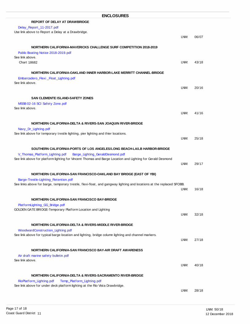
12 December 201850/18LNM:
11Coast Guard DistrictPage 17 of 18
ENCLOSURESREPORT OF DELAY AT DRAWBRIDGE
NORTHERN CALIFORNIA-MAVERICKS CHALLENGE SURF COMPETITION 2018-2019
NORTHERN CALIFORNIA-OAKLAND INNER HARBOR-LAKE MERRITT CHANNEL-BRIDGE
SAN CLEMENTE ISLAND-SAFETY ZONES
NORTHERN CALIFORNIA-DELTA & RIVERS-SAN JOAQUIN RIVER-BRIDGE
SOUTHERN CALIFORNIA-PORTS OF LOS ANGELES/LONG BEACH-LA/LB HARBOR-BRIDGE
NORTHERN CALIFORNIA-SAN FRANCISCO-OAKLAND BAY BRIDGE (EAST OF YBI)
NORTHERN CALIFORNIA-SAN FRANCISCO BAY-BRIDGE
NORTHERN CALIFORNIA-DELTA & RIVERS-MIDDLE RIVER-BRIDGE
NORTHERN CALIFORNIA-SAN FRANCISCO BAY-AIR DRAFT AWARENESS
NORTHERN CALIFORNIA-DELTA & RIVERS-SACRAMENTO RIVER-BRIDGE
Use link above to Report a Delay at a Drawbridge.
See link above.
See link above.
See link above.
See link above for temporary trestle lighting, pier lighting and thier locations.
See link above for platform lighting for Vincent Thomas and Barge Location and Lighting for Gerald Desmond
See links above for barge, temporary trestle, flexi-float, and gangway lighting and locations at the replaced SFOBB.
GOLDEN GATE BRIDGE-Temporary Platform Location and Lighting
See link above for typical barge location and lighting, bridge column lighting and channel markers.
See link above.
See link above for under deck platform lighting at the Rio Vista Drawbridge.
06/07
43/18
20/16
41/16
25/18
29/17
16/18
32/18
27/18
40/18
28/18
LNM:
LNM:
LNM:
LNM:
LNM:
LNM:
LNM:
LNM:
LNM:
LNM:
LNM:
Delay_Report_11-2017.pdf
Public Boating Notice 2018-2019.pdf
Embarcadero_Flexi _Float_Lighting.pdf
MSSB 02-16 SCI Safety Zone.pdf
Navy_Dr_Lighting.pdf
V_Thomas_Platform_Lighting.pdf Barge_Lighting_GeraldDesmond.pdf
Barge-Trestle-Lighting_Retention.pdf
PlatformLighting_GG_Bridge.pdf
WoodwardConstruction_Lighting.pdf
Air draft marine safety bulletin.pdf
RioPlatform_Lighting.pdf Temp_Platform_Lighting.pdf
18682 Chart

12 December 201850/18LNM:
11Coast Guard DistrictPage 18 of 18
NORTHERN CALIFORNIA-CORTE MADERA CREEK-BRIDGE
SOUTHERN CALIFORNIA-SANTA BARBARA CHANNEL-SPEED REDUCTION
NORTHERN CALIFORNIA-SAN FRANCISCO BAY-CHINA BASIN-BRIDGE
SOUTHERN CALIFORNIA-PORTS OF LOS ANGELES/LONG BEACH-CERRITOS CHANNEL-BRIDGE
See link above for Bon Air Rd Temporary Trestle Navigation Channel.
See link above.
See enclosure above.
See link above
29/18
26/18
39/18
45/11
LNM:
LNM:
LNM:
LNM:
THE LOCAL NOTICE TO MARINERS IS AVAILABLE ON THE WORLD WIDE WEB AT HTTPS://WWW.NAVCEN.USCG.GOV
B.J. Thompson, CDRU.S. Coast Guard
Chief Waterways Management Branch
BonAirRd_Trestle.pdf
whale zone.pdf
3rdSt_PlatformLighting.pdf
Trestle_Lighting_Heim.pdf Pier_Removal_Plan_Drawing.pdf


Replacement Schuyler Heim Bridge ProjectTemporary Lighting Diagram during Construction
The temporary trestles provide 75 feet of horizontal clearance and 48.5 feet of vertical clearance from Mean High Water to the lowest hittable portionof the bridge between the trestles.The upstream and downstream trestles are lighted at night with steady burning all-round red lights. The center of the navigation span, between piers 14and 15, is marked at night with all-round steady burning green lights.
48.5 feet VerticalClearance at MHW
75 feet HorizontalClearance betweentrestles
ENCLOSURE ( )


WHALE ADVISORY ZONE
34° 26.847' N 120° 52.253' W
34° 23.92' N 120° 52.253' W
34° 1.372' N 119° 17.317' W
34° 7.129' N 119° 16.358' W
33° 27.901' N 120° 52.253' W
34° 34.431' N 120° 52.253' W
33° 27.901' N117° 42.36' W
Pt. ArguelloPt. Conception
Dana Pt.
R E D U C E D S P E E D 1 0 K T S
1 0 K T S O R L E S S
Santa Barbara
Pt. Dume
VO LUNTARY SPEED REDUCTIO N Z O NEShipping Lane sNO AA Whale Advisory Z one
0 60 12030Nautical Mile s
Ü
Chart not for navigational purposes.NO AA Charts 18720 and 18740
4 JUNE 2018
Ve sse ls transiting the are a be twe e n Point Argue llo and Dana Point, inc lud ing the Traffic Se paration Sc he m e s in the Santa Barbara Channe l and San Pe d ro Channe l should e xe rc ise caution and re d uc e spe e d . The se are as c ontain populations ofe nd ange re d blue , hum pbac k and fin whale s that are fe d e rally prote c te d und e r the Fe d e ral Endange re d Spe c ie s Act(16 U.S.C. 1538 e t se q .), the Marine Mam m al Prote c tion Act (16 U.S.C. 1361 e t se q .), and the National Marine
Sanctuarie s Act (16 U.S.C. 1431 e t se q .).NO AA strongly re c om m e nds that ve sse ls 300 gross re giste re d tons or large r transiting the Santa Barbara Channe l Traffic Se paration Sc he m e be twe e n Point Dum e and Point Argue llo d o so at spe e d s not in e xc e ss of 10 kts due to the
pre se nc e of e nd ange re d whale s in the are a. Ple ase re port any c ollisions with whale s or any obse rve d injure d or d e ad whale s to NO AA at 877-SO S-WHALe
(877-767-9425) or to the U.S. Coast Guard on VHF Channe l 16.
WHALE ADVISORY ZONE AND VOLUNTARY VESSEL SPEED REDUCTION ZONETO REDUCE IMPACT OF SHIP STRIKES ON WHALES
NO AA is asking for the public ’s he lp in trac king whale s. If you se e whale s, ple ase re c ord the date and loc ation,the num be r of whale s, the spe c ie s (if known) and a d e scription of the anim als and re port sightings through
Whale Ale rt, a fre e applic ation available at http://we stc oast.whale ale rt.org.For m ore d e tails, ple ase c ontact Se an Hastings at se [email protected]
or (805) 893-6424.


Cleaning and Repainting ProjectRio Vista Drawbridge
Mile 12.8Sacramento River
Below deck work platforms, installed from the drawspan (pier 6) to the easternshore, will reduce vertical clearance by 4 feet. The upstream and downstreamlower edges of the platforms are lighted at night with steady burning red lights,spaced every 30 feet, visible at 2,000 yards by approaching vessels.
Underdeck Work Platforms

U.S. COAST GUARD REPORT OF DELAY AT DRAWBRIDGE
PER 33 CFR 117.5
BRIDGE NAME: DATE:
MILE : WATERWAY:
1. Name/ Type of Vessel: Direction of Travel :
2. Vessel Owner (Name):
(Address):
3. Name of Pilot (if applicable):
(Address):
4. Time vessel signaled for bridge opening:
5. Location of vessel when signal was given:
6. Time and location of vessel when delay began:
7. Method of signal for bridge opening: ( ) Radio ( ) Sound ( ) Visual.
(If sound or visual signal was used, specify: )
8. Time bridge operator acknowledged signal:
9. Method of bridge operator acknowledgement: ( ) Radio ( ) Sound ( ) Visual
(If sound or visual signal was used, specify: )
10. Did bridge operator acknowledgement indicate the bridge, ( ) Could be opened immediately? ( ) Could not be opened immediately?
11. If land traffic crossed the bridge:
Time land traffic started across the bridge
Time land traffic stopped crossing the bridge
Did land traffic stop on the bridge?
Duration land traffic stopped on the bridge
12. Time drawbridge opened for navigation
13. Additional comments: ___________________________________________________________________________________________________________________________________________________________________________________________________________________________________________________________________________________________________________________________
I certify the above information is true to the best of my knowledge and understand this statement may be used by the U.S. Coast Guard
in levying fines against the bridge owner.
Signature
Telephone
Mariners may complete and return to:
Commander (dpw) Fax: (510) 437-5836 Email: [email protected] Eleventh Coast Guard District Coast Guard Island, Building 50-2 Alameda, CA 94501-5100 Attn: Bridge Office Questions? Please contact: Carl Hausner, Bridge Administrator, Eleventh Coast Guard District Office: (510) 437-3516 Cell: (510) 219-4366 Mariners are reminded not to require bridge openings for appurtenances nonessential to navigation, per 33 CFR 117.11

BOATING PUBLIC NOTICE 2018-2019 Mavericks Surf Competition
The 2018-2019 World Surf League Surf Competition is a one day “Big Wave” surfing competition that only
occurs when 15-20 foot waves are sustained for over 24 hours and are combined with mild easterly winds of
no more than 5-10 knots. These conditions are anticipated to be ideal between November 1, 2018 and
March 31, 2019. Notice of specific dates of times will be announced via Broadcast Notice to Mariners and
published by Coast Guard in a separate Boating Public Notice at least 24 hours in advance of the competition.
The dynamic nature of breaking surf in the vicinity of the event creates inherent hazards for both participants
and spectators. Due to the hazardous waters surrounding Pillar Point at the time of the surfing competition, the
Coast Guard discourages spectators from observing the event on the water. The Coast Guard has established a
Special Local Regulation for the event within the area bounded by an arc extending 1,000 yards from Sail Rock.
The regulation is intended to ensure the safety of competitors by delineating a specific competition area, and to
provide for the safety of spectators by imposing operating restrictions on vessels operating within the regulated
area. Coast Guard and San Mateo County Harbor District assets will be in the event area and ready to respond
in case of an emergency.
Spectators choosing to view the event from the water do so at their own risk, and should exercise extreme
caution, remain aware of changing surf conditions, and ensure their vessel is of appropriate design and
construction and outfitted with proper safety equipment for operation in a dynamic offshore environment. In
the event of an on-water emergency, contact the Coast Guard Command Center at (415) 399-3547 or via
VHF Channel 16.
ZONE 1 – COMPETITION AREA
ZONE 2 – CONTROLLED MOVEMENT
Regulated Area contained within an arc
extending 1,000 yards from Sail Rock:
37 29’34”N, 122 30’02”W
NOAA Chart 18682
ZONES 1 & 2 BOUNDARY LINE
Special Local Regulation; Half Moon Bay, CA,
Mavericks Surf Competition
Chart is not for navigational purposes.
For more information on boating safety and required and recommended safety
equipment, please visit www.uscgboating.org.
For more information on weather conditions, please visit www.weather.gov.

REFERENCE SUBMITTAL 027-001-003 STAGING LAYOUT
Location of FlexiFloats during span6 demolition.
Embarcadero Road Bridge Replacement Project, Mile 0.17, Lake Merritt ChannelTypical Flexi-Float Barge Lighting
City of Oakland Contractor intends to use 3 to 4, 3 foot X 7.5 foot X 30 foot, flexi-float barges during the demolitionof the eastern pier of the existing Embarcadero Rd Bridge. The downstream corners of each flexi-float barge shallbe lighted at night with steady all-round red lights.


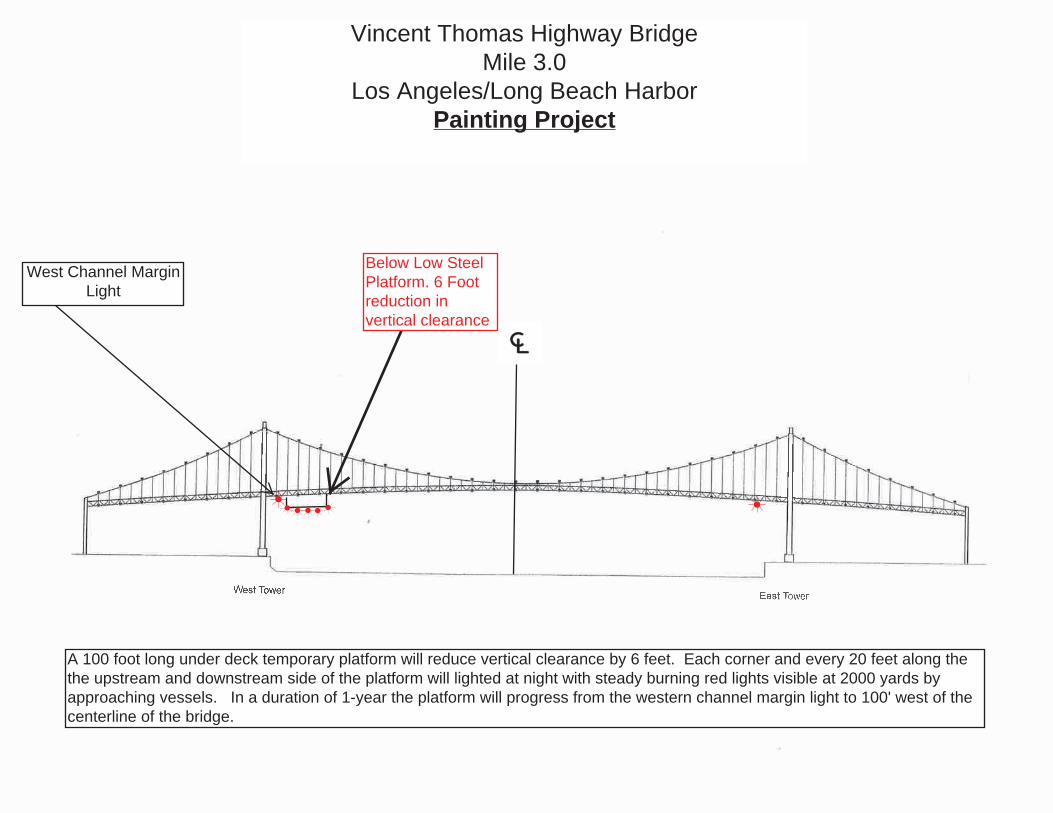
Vincent Thomas Highway BridgeMile 3.0
Los Angeles/Long Beach HarborPainting Project
A 100 foot long under deck temporary platform will reduce vertical clearance by 6 feet. Each corner and every 20 feet along thethe upstream and downstream side of the platform will lighted at night with steady burning red lights visible at 2000 yards byapproaching vessels. In a duration of 1-year the platform will progress from the western channel margin light to 100' west of thecenterline of the bridge.
Below Low SteelPlatform. 6 Footreduction invertical clearance
West Channel MarginLight

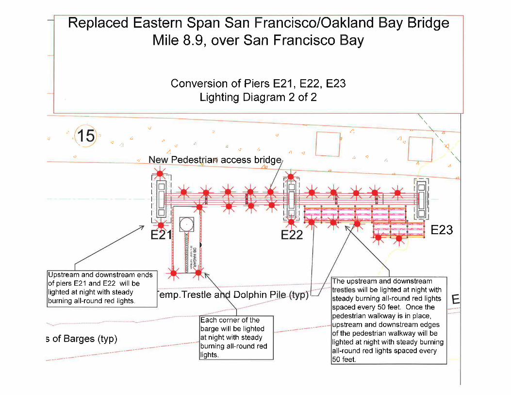


.
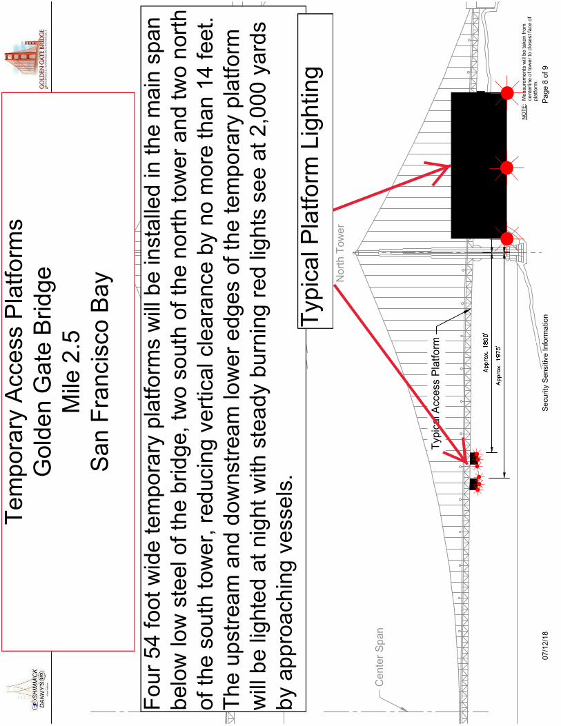
No
rth
Tow
er
Ce
nte
r S
pan
No
rth
Tow
er
Ce
nte
r S
pan
Typ
ical
Acc
ess
Pla
tfo
rm
NO
TE
: M
easu
rem
ents
will
be
take
n fr
omce
nter
line
of t
owe
r to
clo
sest
face
of
pla
tform
.
NO
TE
: M
easu
rem
ents
will
be
take
n fr
omce
nter
line
of t
owe
r to
clo
sest
face
of
pla
tform
.
Typ
ical
Acc
ess
Pla
tfo
rm
07/1
2/1
8S
ecu
rity
Sen
sitiv
e In
form
atio
nP
age
8 o
f 9
Te
mp
ora
ryA
cce
ssP
latf
orm
sG
olde
nG
ate
Brid
ge
Mile
2.5
San
Fra
ncis
coB
ay
Fo
ur
54
foot
wid
ete
mp
ora
ryp
latfo
rms
will
be
inst
alle
din
the
mai
nsp
anb
elow
low
ste
elo
fth
ebr
idg
e,tw
oso
uth
ofth
en
ort
hto
we
ra
nd
two
nor
tho
fth
eso
uth
tow
er,
red
ucin
gve
rtic
alcl
ear
anc
eby
nom
ore
than
14fe
et.
Th
eup
stre
am
and
dow
nst
rea
mlo
we
re
dge
sof
the
tem
po
rary
pla
tfor
mw
illb
elig
hte
dat
nig
htw
ithst
ead
ybu
rnin
gre
dlig
hts
see
at2
,000
yard
sb
yap
pro
ach
ing
vess
els
.T
ypic
alP
latfo
rmLi
ghtin
g.